Hellenic Karst Aquifers Vulnerability Approach Using Factor Analysis: The Example of the Louros Karst Aquifers


Laboratory of Hydrogeology, Department of Geology, University of Patras, 26504 Rio Patras, Greece
Geosciences 2018, 8(11), 417; https://doi.org/10.3390/geosciences8110417
Submission received: 23 July 2018
/
Revised: 30 October 2018
/
Accepted: 5 November 2018
/
Published: 13 November 2018
(This article belongs to the Special Issue Inland and Coastal Karst Aquifers: Functioning, Monitoring and Management)
Abstract
:The karst aquifers of the Hellenic territory display high vulnerability that is related to the existence of the epikarst zone. If present, the epikarst zone regulates the vertical movement of the groundwater, which results in the chemical pollutants staying longer within it, thus facilitating the inactivation of the microbial loads. The Hellenic karst is well developed; it displays high hydraulic conductivity, relatively large storage, and the characteristics of an important water reservoir. Although its porosity was calculated to be between 0.005–8%, the statistical processing of the springs’ discharge time series points to an increased storage. The increased storage was attributed to the presence of the epikarst zone, which regulates the water movement to the underlying formations, and finally to its discharge from the karst system through springs. In these areas, the influence of nitrogen compounds on the water quality is evident. The presence of cyanobacteria and toxic substances at concentrations that are too high for fresh, flowing waters whose temperature does not exceed 17 °C advocates the role of nutrients, even at concentrations that do not exceed the maximum permissible limits of drinking water. In mountainous areas, where agriculture is limited, the presence of these compounds is attributed to heavily polluting land uses. The impact of such uses became apparent from the application of factor analysis, which not only highlighted their contribution to the overall groundwater quality, but also determined their geographical distribution and origin. From the above, it becomes evident that there is a need for protection of the karst aquifers, and investigation of their vulnerability mechanisms. The Hellenic karst, which is expected to cover the drinking water needs in the near future, proves to be very vulnerable to any kind of pollution.
1. Introduction
In previous years, the drinking water and irrigation needs were covered by the easily accessible aquifers of granular geological formations. The relative isolation of carbonated aquifers in mountainous areas has contributed to maintaining the view of their good water quality characteristics. However, the water quality degradation of the granular aquifers, which was mainly due to seawater intrusion caused by over-pumping, has turned the interest to the study of carbonate formations, and highlighted the impact of anthropogenic activities on water pollution. Nowadays, the eutrophic conditions and the certain substances that have been observed in lakes’ water are due to their pollution by human activities.
Although the large water quantities that are commonly circulating through the karst formations help in the dilution of the pollutants, the statistical processing of the chemical analyses reveals the domination of the nitrogen compounds, and thus the presence of eutrophication.
Karst aquifers are characterized by high groundwater velocities and low storativity. These two properties contribute to the immediate restoration of the quality of the polluted aquifers, provided that the pollution sources are eliminated. However, recent research has shown that the presence of the epikarst zone has a positive effect on the function of these aquifers, as it slows down the vertical movement of the water therein, and creates storage conditions. However, precisely due to its presence, the view of rapid restoration needs to be revised.
In the present study, aiming at the qualitative investigation of the vulnerability of karst aquifers: (a) the basic characteristics of the Hellenic karst are given where similarities among the karst formations in relation to their hydraulic properties and the presence of the epikarst zone can be noticed; (b) the role of the epikarstic zone as the regulator of the vertical movement of water is highlighted; and (c) Louros Basin, which is a typical example of one of the most significant and representative karst systems in the country, in terms of both its geological structure and its land uses, is discussed.
In order to investigate the origin of pollution, hydrochemical data has been processed with the use of factor analysis. The proposed methodology can be useful to study other karst aquifers that have similar characteristics.
2. Methodology
Along the Louros watershed, five samplings were carried out between October 2008 and May 2010 from springs, boreholes, and surface waters. In the present study, the data from the 27–28 February 2010 sampling—which was considered to be the most representative—was elaborated using factor analysis. The samples were collected from 65 sampling points according to the United States (US) Environmental Protection Agency (EPA) (1976) procedures [1]. Seawater and rainwater samples were also collected [2,3].
The water temperature, pH, dissolved oxygen, electrical conductivity, and redox potential were measured in situ using a Hana® HI 9828 portable instrument. Additionally, alkalinity was measured at the site using a Hach® Digital Titrator.
Three different water samples in acid-washed, well-rinsed polyethylene bottles for subsequent analyses were collected from each sampling site. The first 1-L volume contained a bulk water sample for the anion analysis. The second 0.1-L volume contained water filtered through a Whatman 0.45-μm cellulose membrane and acidified with 0.5 mL of ultrapure HNO3 for the determination of metals. The third contained bulk sample for the isotopic analyses.
All of the chemical analyses were performed in the Laboratory of Hydrogeology, University of Patras within hours from collection. Anions (NO3−, NO2−, SO42−, and F−), P, NH4+, and SiO2 concentrations were measured with a Hach® DR 4000 spectrophotometer. The Cl− content was determined using AgNO3 0.1 N titration.
Major cation (Ca2+, K+, Mg2+, Na+) concentrations were determined using a GBC® Avanta P flame atomic absorption spectrophotometer. The charge balance error for all of the chemical analyses is within a highly acceptable range (±5%). Chemical calculations such as the saturation indices were performed using PHREEQC version 3.0 [4].
Along the Louros Basin, there is a large number of livestock, poultry farms, and fish farms, as well as inhabited areas. In order to detect the possible pollution of the groundwater resulting from these uses, samplings and microbiological analyses were also carried out in February 2010, which is the month with the highest water levels, on 46 surface and groundwater samples. The samples were stored in sterile glass bottles and analyzed for microorganisms, total coliforms, Escherichia coli, Enterococcus, sulfite-reducing clostridia, and the total number of microorganisms at 22 °C and 37 °C in the Public Health Laboratory at the Department of Medicine of the University of Patras.
3. The Hellenic Karst
A large part of the Greek territory, exceeding 35%, is predominantly covered by Mesozoic carbonate formations. The Hellenic karst systems were developed during the Alpine orogeny that took place between Jurassic and Miocene [5]. Lateral movements in the upper Eocene (e.g., the Pindos napple, the Pelagonian napple), intense tectonism at the end of the upper Miocene, as well as the eustatic movements of the Mediterranean Sea during the glacial and interglacial periods created the necessary conditions for the karstification of the carbonate formations of the different geotectonic zones.
According to [6], in the Hellenic karst, the following types can be distinguished:
- The “paleokarst” that was developed during the upper Cretaceous and upper–lower Miocene under warm–wet climates (Savanna type), which is not currently evolving and is considered as inactive, fossilized.
- The “younger karst” that was developed during Pleistocene–Holocene between the interglacial periods, under climatic conditions that are usually warmer and wetter than today. The main karstification process of the Greek territory took place during the same period, and was also accompanied by the creation of new karst forms, and sometimes the reactivation of older ones that often continue to evolve, even to this day.
- The “recent karst”, which is created under the current climatic conditions, and is characterized by surface karst features, e.g., karrens.
The large karst basins, which were already formed in the Miocene, constitute a well-developed paleokarst contrary to the next generation of smaller-sized basins that began to form during Plio–Pleistocene and lower Pleistocene [7].
The majority of the available data for the Hellenic karst originates from the IGME (Institute of Geology & Mineral Exploration) surveys. The most well-known studies focus on the central Peloponnese and Western Greece, where the carbonate formations of the Ionian, Gavrovo–Tripolis, and Olonos–Pindos zones are mainly developed. Additionally, individual studies provide important information for other areas, for example [8] for the Pre-Apulian zone, [9,10] for the Parnassos-Giona zone, [11] for the Pelagonian and Attico–Cycladic zones, [12] for the Koziakas Mountain, [13] for the crystalline limestones of the Rhodope massif, and others [14].
The main development of the karst, in its holokastric form, is observed in the lithological homogeneous thick bedded limestones of the Cretaceous–Senonian age of the Ionian, Gavrovo–Tripolis, Parnassos–Giona, and Pelagonian zones (Figure 1). The thin-bedded limestones, particularly due to the presence of radiolarian cherts such as those of the Ionian zone (Vigla), Pindos zone, etc., exhibit a lower karstification degree. According to [15], they form karst systems that are classified as merokarst.
In the western and central Greece and in the Peloponnese, where holokarst formations are found in the Ionian, Parnassos–Giona, Pelagonian, and Gavrovo–Tripolis Zones, respectively, all of the exokarst and endokarst features such as dolines, poljes, and caves are present.
In merokarst, the most developed features, due to karst erosion, are small dolines. Holokarstic features are distinguished by increased transmissivity, ranging from 2 × 101 m2/s to 9 × 10⁻⁶ m2/s, and very low storativity, ranging from 0.5 × 10⁻⁴ to 0.08 [16]. In these formations, groundwater is moving through conduits of large, but also smaller diameters.
In merokarst, the movement of water is carried out through cracks and fractures. In the case of the coexistence of two karst structures, the strong differentiation in hydraulic conductivity forces the latter to behave as relatively impervious to the former, e.g., Senonian and Vigla limestones of the Ionian zone [17].
In the central Peloponnese, the lithological variations of these structures, as well as their stratigraphic position—the merokarst limestones of the Pindos zone overlap with the holokarst formations of Gavrovo–Tripolis zone—lead to the development of sinkholes in the thick-bedded, and lithologically homogeneous limestones of the Gavrovo–Tripolis zone [18].
3.1. The Role and Presence of the Epikarstic Zone in General, and in the Hellenic Karst
The importance of the epikarst, as a zone of particular characteristics, has emerged from studies of various researchers since the 1970s. The identification of aquatic fauna at the cave’s ceiling pre-required the existence of a saturated zone in between the ground and the ceiling of the caves.
Mangin [20,21] studied karst springs’ hydrographs, and concluded that there should be some kind of water storage occurring on the upper part of the unsaturated zone. Bakalowicz et al. [22] observed variations in the hydrochemical and isotopic composition of groundwater before it reaches the aquifer, which was attributed to water storage on the upper part of the unsaturated zone. Kiraly and Morel [23], in order to obtain a typical hydrograph form, during simulations of karst aquifers, highlighted the need for water storage on the upper part of the unsaturated zone. The speleologists [24,25], during their investigations in central Asian mountains, concluded that the presence of water in the unsaturated zone after a long period of drought can only be attributed to water storage on the upper part of this zone. This resulted in the presence of a zone near the soil surface that behaves as a recharge zone for the underlying karst system. Mangin [20,21] named this zone as “epikarst”, and pointed to the presence of a perched aquifer within it.
The great significance of epikarst, in relation to the propagation of pollutants in karst aquifers, was highlighted by White and White [26] for its role in the dissemination of NAPLs. The epikarst often acts as a reservoir that delays the karst recharge [21,27,28,29,30,31].
The presence of the epikarst zone was investigated by many researchers through the statistical processing of springs’ discharge data. The correlogram describes the memory of the karst aquifers. “Memory time” is the time needed for the original conditions to no longer affect the functioning of the aquifer, that is, the aquifer may “cease to remember the original conditions”. It gives information on the degree of karstification as well as on the water reserves [32,33,34], since long memory corresponds to high porosity and small development, and vice versa.
The research on the karst formations that is known to have taken place in Greece does not refer to the epikarst zone. The published hydrogeological data mainly concern the determination of hydraulic properties using the standard methodology of pumping tests, wherefrom very low storage values were obtained. On the contrary, the exploration of different karst formations throughout the country (Figure 2), and the statistical analysis of the springs’ discharge data, pointed out that in every case, there seems to be a factor that regulates the groundwater discharge that would correspond to increased porosity. In particular, the following results were derived:
- (a)
- The coastal karst aquifers of Trifylia consist of Eocene carbonate formations, while the corresponding areas of Almyros spring in Heraklion area consist of the Triassic carbonate rocks of the Ionian zone and Cretaceous limestones of the Gavrovo–Tripolis zone.
Panagopoulos and Lambrakis [35] comparatively studied the characteristics of hydrographs of the daily springs’ discharge values of these karst aquifers, and found that they display long memory (lag time >50 days), which corresponds to increased porosity and direct aquifers’ response to the rainfall, as well as instant drainage and high velocity of groundwater, i.e., increased hydraulic conductivity. Similar conclusions were also drawn for the Almyros aquifer by [36], who associated the increased memory to an increased porosity of the formations. However, since the measured porosity is very small, the increased memory could be attributed to the presence of the epikarst zone.
- (b)
- The karst system of the Louros Basin consists of carbonate formations of the Ionian zone. From the springs’ discharge data for the Eocene limestones of the area, a long memory emerged just as in the previous case (lag time between 70–100 days) corresponding to increased porosity, which is explained by the presence of the epikarst zone [2,37]. It was also found that the very good drainage of the aquifers corresponds to a developed karst system.
- (c)
- The karst system hosted in the marbles of Aggitis presented similar results regarding the autocorrelation and cross-correlation functions, and thus similar characteristics with the above-mentioned systems [13]. The lag time of 50 days for the autocorrelation function was attributed to the system’s long memory, corresponding to an increased storage, which could explain the huge water reserves that were calculated by the recharge area of the springs. Given the very low porosity that was measured in the area, the increased memory was attributed to the presence of snow that accumulates on mountain tops and can play a regulatory role in the discharge of the springs’ groundwater. According to [14], the increased memory could also be attributed to the presence of the epikarst zone.
3.2. The Louros Basin: Area of Application
3.2.1. Geological and Hydrogeological Setting of Louros Basin
The study area receives increased precipitation rates throughout most of the year (mean annual precipitation around 1700 mm). The extent of the basin is relatively limited, and its morphology does not display extensive flattened areas and exokarstic forms. However, the occurrence of karst features and the presence of large areas covered by terra rossa are common.
It is hosted in the formations of the Ionian zone [39]. The oldest ones consist of evaporitic layers of early to middle Triassic age (Figure 3), locally overlain by breccias [40].
These formations are overlain by a thick sequence of carbonate and clastic rocks reflecting a continuous sedimentation from late Triassic to upper Eocene [41]. The Pantokrator and Upper Senonian limestones are considered to be permeable, and their storage coefficient values range between 2–3% [42,43]. Clastic limestones of Eocene and Vigla limestones are considered to be of low permeability.
The latter formation [17], when it underlies limestones of high permeability such as the Senonian ones, constitutes the base level of the local aquifer, under which karstification is very limited or absent. Dolomites, shales, Ammonitico Rosso, and flysch formations are considered to be of very low permeability. Finally, the Neocene and Quaternary deposits also display low permeability compared to the carbonate rocks. The major tectonic features of the region are folds with their axes trending SW–NE and NNW–SSE. The broader area is characterized by a continuous succession of synclines and anticlines with a general direction of NNW to SSE. Such synclines, filled with flysch, limit the area to the east and west and control the movement of water.
Strike-slip fault systems display the same directions while younger ones, normal to the previous ones, create a tiered structure and contribute to the formation of individual karst units. Finally, diapirism resulted in the slip surfaces of gypsum, which facilitated the over-thrusting, contributing to the complex tectonic structure, and affecting groundwater quality.
The most important aquifers of the area are hosted in the Pantokrator and Upper Senonian limestones. They display high permeability due to intense karstification and fracture porosity. Individual karst units, which are more or less interconnected, form a karst system that is drained by the Louros River. These units are discharged by a number of karst springs that are distributed at three distinct levels where the three aquifers are developed [45].
3.2.2. The Pollution Sources and Origin of Groundwater in Louros Basin
Groundwater samples of the Louros Basin fall under the category of oligometalic carbonate waters of Ca-HCO3 type. They are freshwaters that are affected by the diapirism of the evaporites in the central part of the basin, while they are affected in the southern part and the lowlands by the presence of hypothermal water [46]. The electrical conductivity (EC) ranges between 147–923 μS/cm. The higher values correspond to the samples from the southern part of the basin, while the average value above that part is 598 μS/cm. Nitrate concentrations range between two and 11 mg/L.
Katsanou et al. [46] using the chemical components and isotopic signatures of groundwater, reported that the Louros karst system is recharged by rainwater, while it is isolated from adjacent ones, including the Ioannina Basin, beyond the northern margins of the Louros Basin. Thus, both nutrient and microbial loads are produced within the basin, and are attributed to human activities.
In the autumn months, when the temperature is higher, there is a thick layer of cyanobacteria on the surface of Lake Ziros. The water surface of the lake is a continuation of the surface of the aquifer hosted in the carbonated rocks of the wider area, and is being discharged through springs along its margins.
According to [47], cyanobacterial blooms is a phenomenon that occurs in Lake Ziros due to the presence of the Planktothrix rubescens species. At the same time, microcystin concentrations were determined to be the highest that were ever identified in Greek ecosystems. The level of the microcystins that were measured in cyanobacterial pellets were also found to be among the highest in the world. According to [48], microcystins are toxic substances that could cause serious damage to human health through drinking water, while studies at the University of Oregon showed that they grow in stagnant fresh waters under high temperature and nutrient supply [49].
Although the density of the sampling points is not considered satisfactory due to objective difficulties, i.e., the lack of sampling points in mountainous karst areas, microbial determinations revealed the presence of microbial load in the majority of samples. From the distribution of microbial parameters (Figure 4), it appears that non-pathogenic microorganisms are found throughout the basin with significant concentrations as a result of point and not diffuse sources.
3.2.3. The Application of R-Mode Factor Analysis in Louros Basin
The application of factor analysis on chemical data can play a key role in hydrochemical research. Several methods such as principal component analysis, cluster analysis, discriminant analysis, and factor analysis are available [50]. The R-mode factor analysis is applied to investigate the relationships between a large number of hydrochemical parameters (15) and samples (65), aiming to create a much smaller number of factors that will express without loss—if possible, or with the least possible loss of statistical information, the groundwater quality [51]. The theoretical part is omitted, while SPSS 24.0 [52] was used to process the data.
In the chemical analyses of the groundwater samples that were collected from the area, both R-mode and Q-mode factor analyses were applied. For the R-mode, the first four factors were selected on the basis of the criterion that the values of the coefficients are greater than or equal to one (Table 1, column 1). The overall variation amounted to 76.8% of the total statistical information (Table 1, column 3).
The first factor, which accounts for about 40% of the total variance, presents high loadings on major ions, HCO3−, K+, Na+, Mg2+, NH3, P, and Cl− (Table 2), which suggests that the chemical composition of water is mainly formed by these ions. This relationship is valid for the majority of natural waters [50]. The presence of phosphorus, which is not only linked to human activities such as NH3, but might also be related to the presence of phosphorites in the area, is highlighted by the first factor. This factor indicates the significant contribution of P to the groundwater’s chemical composition, which increases the nutrients’ content, and leads to the development of eutrophication.
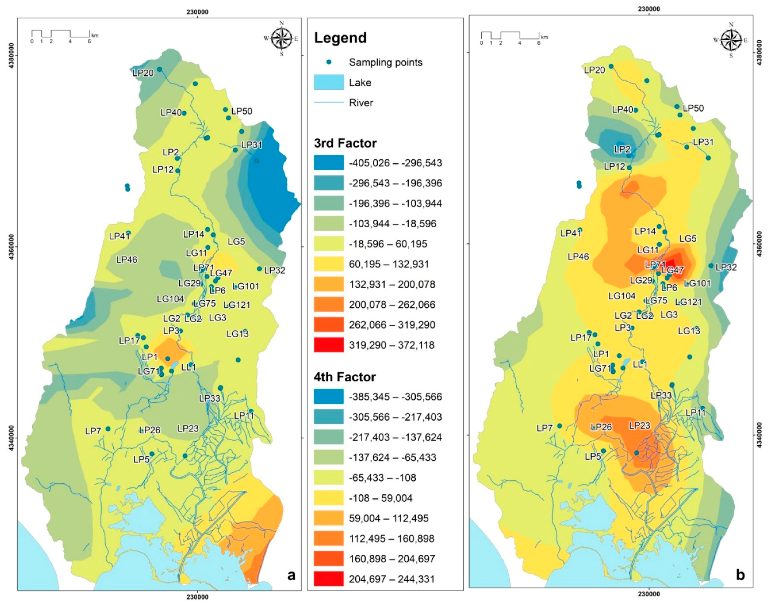
The second factor, with a total variation of 15%, exhibits high loadings for Ca2+ and SO42 ions, clearly indicating the effect of gypsum on the groundwater quality of the area [46]. The third factor highlights the relationship between NO2− concentrations and temperature. The highest NO2− concentrations are abundant in the central part of the area (Figure 5a). In this part, the water level is very close to the ground surface, and the groundwater is influenced by the atmospheric temperature. The fourth factor links the NO3− concentrations to pH. The highest concentrations of nitrates are related to the inhabited areas (Figure 5b). The last two factors, with a cumulative variance of about 20% of the total variance, demonstrate the effect of nitrogen compounds on the chemical composition of groundwater, as well as the presence of pollution.
The application of the Q-mode factor analysis led to the extraction of the factors’ scores that in turn led to the mapping of the sampling positions and the respective contribution of each of them to the presence of these factors.
Figure 5 shows the distribution maps of the third and the fourth factor that are related to pollution processes. Figure 5a presents the distribution of the third factor, which has to do with the presence of nitrites. It appears that the higher factor scores occur in the central and eastern segments of the basin where most agglomerations and human activities are concentrated. Figure 5b is completely analogous to the previous one.
4. Discussion and Conclusions
The inner continental karst basins are promising water reservoirs for the near future. They are mainly known for: (a) their inaccessibility due to their steep relief; (b) their isolation from the effect of the sea, since they are mostly remote from coastal areas; (c) their cold climate and their high precipitation rates; (d) the large springs that they host, and (e) the limited human activities that they accumulate.
The Hellenic karst aquifer systems present both similarities and differences due to their geological structure and karstification degree. The similarities include good drainage conditions, low storage, and long memory, which corresponds to a regulating factor of the groundwater discharge of these formations that could be attributed to the presence of an epikarst zone.
Although the combination of large quantities of water ensures the dilution of pollutants and the inaccessibility of the area limits farming, and hence the use of fertilizers, it appears that land uses such as the inhabited areas and the poultry farms are sufficient to create widespread pressures and the degradation of water quality.
The concentrations of nitrates determined in surface and groundwater samples by [46] did not exceed 25 mg/L, but along with other nutrients, they are considered to be responsible for the presence of cyanobacteria.
Although karst formations are ultimately susceptible to pollution, their susceptibility is very difficult to calculate. Chemical pollutants are favored by the presence of the epikarst zone because during polluting episodes, they accumulate within it, and are gradually released during the first rains of the next wet period to the underlying karst aquifers. Microbial loads propagate directly during wet periods mainly through surface drainage. Therefore, the need to protect these aquifers, and study their pollution susceptibility, becomes imperative.
Funding
This research received no external funding.
Acknowledgments
The author expresses her gratitude to the personnel of the Laboratory of Public Health of the Medical School, University of Patras, Greece and especially Michalis Leotsinidis for the determination of the microbial loads. Moreover, the author gratefully acknowledges the constructive criticism and helpful suggestions provided by the editors and the reviewers of the initial version of this paper, which are reflected in the present version.
Conflicts of Interest
The author declares no conflicts of interest.
References
- USEPA Publications. US EPA Quality Criteria for Water; USEPA Publications: Washington, DC, USA, 1976.
- Katsanou, K. Environmental Hydrogeological Study of Louros watershed, Epirus, Greece. Ph.D. Thesis, Department of Geology, University of Patras, Rio, Greece, 2012. [Google Scholar]
- D’Alessandro, W.; Katsanou, K.; Lambrakis, N.; Bellomo, S.; Brusca, L.; Liotta, M. Chemical and isotopic characterisation of bulk deposition in the Louros Basin (Epirus, Greece). Atmos. Res. 2013, 132–133, 399–410. [Google Scholar] [CrossRef]
- Parkhurst, D.L.; Appelo, C.A.J. Description of Input and Examples for PHREEQC Version 3-A Computer Program for Speciation, Batch-Reaction, One-Dimensional Transport and Inverse Geochemical Calculations: U.S. Geological Survey Techniques and Methods. 2013. Available online: http://pubs.usgs.gov/tm/06/a43/ (accessed on 5 November 2018).
- Kallergis, G. Applied—Environmental Hydrogeology, 2nd ed.; TEE: Athens, Greece, 2001; ISBN 978-960-7018-73-1. [Google Scholar]
- Papadopoulou-Vrinioti, K. Hellenic karst and Environment. In Proceedings of the 3rd Pan-Hellenic Geographical Conference, Athens, Greece, 1–3 April 1993; pp. 290–299. [Google Scholar]
- Riedl, H.; Papadopoulou-Vrinioti, K. Comparative Investigations on Karst Generations Mainly in the Aegean Archipelago. Mitt. Natutwiss Ver. Steiermark 2001, 131, 23–39. Available online: https://www.zobodat.at/pdf/MittNatVerSt_131_0023-0039.pdf (accessed on 1 June 2018).
- Koumantakis, I.E. Research of Kefalonia Aquifers, Geographical and Morphological Data, Geological Conditions and Hydrogeology. Unpublished Technical Report. 1990. [Google Scholar]
- Mastoris, K. Hydrogeological Investigation in the Karstic Limestone Area of South Ghiona. Ph.D. Thesis, NTUA, Athens, Greece, 1968. [Google Scholar]
- Monopolis, D. Hydrogeological Study of the Karst Area of the Mountainous Complex of Parnassos. Ph.D. Thesis, Athens, Greece, 1971. [Google Scholar]
- Morphis, A. Hydrogeological Research of the Karst Aquifer System of Parnitha and the Wider Area of Northern Attica. Ph.D. Thesis, University of Patras, Rio, Greece, 2005. [Google Scholar]
- Papadopoulos, K. Hydrogeological Research of the Wider Area of Koziakas Mountain Range (Western Thessaly). Ph.D. Thesis, University of Patras, Rio, Greece, 2004. [Google Scholar]
- Novel, J.-P.; Dimadi, A.; Zervopoulou, A.; Bakalowicz, M. The Aggitis karst system, Eastern Macedonia, Greece: Hydrologic functioning and development of the karst structure. J. Hydrol. 2006, 334, 477–492. [Google Scholar] [CrossRef]
- Lambrakis, N. The Hellenic karst. Propositions for research methodologies and application examples. In Proceedings of the 11th International Hydrogeological Congress of Greece, Athens, Greece, 4–6 October 2017. [Google Scholar]
- Cvijic, J. Državna štamparija Kraljevine Srba; Hrvata i Slovenaca: Zagreb, Beograd, 1926. [Google Scholar]
- Mandilaras, D.; Voudouris, K.; Soulios, G. Hydraulic parameters in the karstic aquifer system of Greece. In Proceedings of the International Conference “All about karst & water”, Vienna, Austria, 10–11 October 2006; pp. 118–129. [Google Scholar]
- Smyrniotis, C. Preliminary Report of Louros Karst System Hydrogeological Study; Technical Report; Institute of Geological and Mineral Research: Thessaloniki, Greece, 1991; ISBN 960-602-058-4. [Google Scholar]
- Gospodaric, R.; Habic, P. Poljes of hotoussa, levidi and northern tripolis. In Karst Hydrogeology of the Central and Eastern Peloponnesus (Greece); Morfis, A., Zojer, H., Eds.; Steirische Beiträge zur Hydrogeologie: Graz, Austria, 1986; pp. 169–185. [Google Scholar]
- Lambrakis, N.; Katsanou, K.; Siavalas, G. Geothermal fields and thermal waters of Greece: An overview. In Geothermal Systems and Energy Resources: Turkey and Greece, 1st ed.; Baba, A., Bundschuh, J., Chandrasekharam, D., Eds.; CRC Press, Taylor and Francis Group: London, UK, 2014; pp. 25–46. ISBN 9781138001091. [Google Scholar]
- Mangin, A. Sur la dynamique des transferts en aquifére karstique. In Proceedings of the 6th International Congress of Speleology, Olomouc, Czech Republic, 22–28 July 2017. [Google Scholar]
- Mangin, A. Contribution A L’etude Hydrodynamique Des Aquiferes Karstiques. Ph.D. Thèse, Université de Dijon, Dijon, France, 1975. [Google Scholar]
- Kiraly, L.; Morel, C. Remarques sur l’hydrogramme des sources karstiques simule par modeles mathematiques. Bull. Cent. Hydrogeol. 1992, 1, 37–60. [Google Scholar]
- Bakalowicz, M.; Blavoux, B.; Mangin, A. Apports du ravage isotopique naturel a la connaissance du fonctionnement d’un systeme karstique-leneurs en oxygene 18 de trois systemes des Pyrenees, France. J. Hydrol. 1974, 23, 141–158. [Google Scholar] [CrossRef]
- Klimchouk, A.B.; Stotland, V.J.; Lomaev, A.A. Karstological and speleological investigations of the Kyrktau massif (Zeravshansky Ridge, Tjan-Shan). Izvestija VGO 1979, 11, 117–123. Available online: https://www.researchgate.net/publication/273276723 (accessed on 1 June 2018).
- Klimchouk, A.B.; Rogozhnikov, V.; Ja Lomaev, A.A. Karst of the Kyrklau Massif, Zeravshansky Ridge; Institute of Geological science: Kiev, Ukraine, 1981.
- White, W.B.; White, E.L. Karst landforms and drainage basin evolution in the Obey River Basin, north-central Tennessee. J. Hydrol. 1983, 61, 69–82. [Google Scholar] [CrossRef]
- Aquilina, L.; Ladouche, B.; Dorfliger, N. Water storage and transfer in the epikarst of karstic systems during high flow periods. J. Hydrol. 2016, 327, 472–485. [Google Scholar] [CrossRef]
- Bakalowicz, M. La zone d’infiltration des aquifères karstiques. Méthodes d’étude/Structure et fonctionnement. Hydrogéologie 1995, 4, 3–21. [Google Scholar]
- Einsield, F. Flow system dynamics and water storage of a fissured porous karst aquifer characterized by artificial and environmental tracers. J. Hydrol. 2005, 279, 312–321. [Google Scholar] [CrossRef]
- Perrin, J.; Jeannin, P.Y.; Zwahlen, F. Epikarst storage in a karst aquifer, a conceptual model based on isotopic data, Milandre test site, Switzerland. J. Hydrol. 2003, 279, 106–124. [Google Scholar] [CrossRef]
- Fidelibus, M.D.; Balacco, G.; Gioia, A.; Iacobellis, L.; Spilotro, G. Mass transport triggered by heavy rainfall: The role of endorheic basins and epikarst in a regional karst aquifer. Hydrol. Process. 2017, 31, 394–408. [Google Scholar] [CrossRef]
- Mangin, A. Pour une meilleure connaissance des systemes hydrologiques a partir des analyses correlatoires et spectrales. J. Hydrol. 1984, 67, 25–43. [Google Scholar] [CrossRef]
- Padilla, A.; Pulido-Bosch, A. Study of hydrographs of karstic aquifers by means of correlation and cross-spectral analysis. J. Hydrol. 1995, 168, 73–89. [Google Scholar] [CrossRef]
- Bouchaou, L.; Mangin, A.; Chauve, P. Turbidity mechanism of water from a karstic spring: Example of the Ain Asserdoune spring (Beni Mellal Atlas, Marocco). J. Hydrol. 2002, 265, 34–42. [Google Scholar] [CrossRef]
- Panagopoulos, G.; Lambrakis, N. The contribution of time series analysis to the study of the hydrodynamic characteristics of the karst systems: Application on two typical karst aquifers of Greece (Trifilia, Almyros Crete). J. Hydrol. 2006, 329, 368–376. [Google Scholar] [CrossRef]
- Bonacci, O.; Fistanic, I. Contribution to hydrological analysis of the coastal karst spring Almyros (Crete, Greece). In Proceedings of the Conference on Water Observation and Information System for Decision Support, Balwois, Ohrid, Macedonia, 25–29 May 2004. [Google Scholar]
- Katsanou, K.; Lambrakis, N.; Tayfur, G.; Baba, A. Describing the Karst Evolution by the Exploitation of Hydrologic Time-Series Data. Water Resour. Manag. 2015, 29, 3131–3147. [Google Scholar] [CrossRef] [Green Version]
- Soulios, G. General Hydrogeology; Kyriakidis Bros Publishing House: Thessaloniki, Greece, 2004; Volume III. [Google Scholar]
- Katsikatsos, G. Geology of Greece; Patras University Publications: Pátra, Greece, 1992. [Google Scholar]
- Karakitsios, V.; Pomoni-Papaioannou, F. Sedimentological Study of the Triassic Solution-collapse Breccias of the Ionian zone (NW Greece). Carbonate Evaporites 1998, 13, 207–218. [Google Scholar] [CrossRef]
- Skourtsis-Coroneou, V.; Solakius, N. Calpionellid zonation at the Jurassic/Cretaceous boundary within the Vigla Limestone Formation (Ionian Zone, western Greece) and carbon isotope analysis. Cretac. Res. 1999, 20, 583–595. [Google Scholar] [CrossRef]
- Nikolaou, E.; Lagaris, V. Technical Report on the Results of the Drilling Research (May 1987–November 1988) Epirus, Greece; Institute of Geological and Mineral Research: Preveza, Greece, 1990. [Google Scholar]
- Nikolaou, E.; Pavlidou, S.; Katsanou, K. Aquifer systems of Epirus, Greece: An overview. In Advances in the Research of Aquatic Environment, Environmental Earth Sciences; Lambrakis, N., Stournaras, G., Katsanou, K., Eds.; Springer: Berlin/Heidelberg, Germany, 2011; Volume 1, pp. 425–434. ISBN 978-3-642-19901-1. [Google Scholar]
- IGRS-IFP (Institut de Géologie et Recherches du Sous-sol–Institut Français du Pétrole). Etude Géologique de l’Epire (Grèce Nord-Occidentale); Editions Technip: Paris, France, 1966. [Google Scholar]
- Katsanou, K.; Lambrakis, N. Modeling the Hellenic karst catchments with the Sacramento Soil Moisture Accounting model. Hydrogeol. J. 2017, 25, 757–769. [Google Scholar] [CrossRef]
- Katsanou, K.; Lambrakis, N.; D’Alessandro, W.; Siavalas, G. Chemical parameters as natural tracers in hydrogeology: A case study of Louros karst system, Greece. Hydrogeol. J. 2017, 25, 487–499. [Google Scholar] [CrossRef]
- Vareli, K.; Briasoulis, E.; Pilidis, G.; Sainis, I. Molecular confirmation of Planktothrix rubescens as the cause of intense, microcystin-Synthesizing cyanobacterial bloom in Lake Ziros, Greece. Harmful Algae 2009, 8, 447–453. [Google Scholar] [CrossRef]
- Dawson, R.M. The toxicology of microcystins. Toxicon 1998, 36, 953–962. [Google Scholar] [CrossRef]
- Otten, T. Toxic Algal Blooms Behind Klamath River Dams Create Health Risks Far Downstream. Oregon State University. 2016. Available online: http://today.oregonstate.edu/archives/2015/jun/toxic-algal-blooms-behind-klamath-river-dams-create-health-risks-far-downstream (accessed on 5 November 2018).
- Lambrakis, N.; Antonakos, A.; Panagopoulos, G. The use of multicomponent statistical analysis in hydrogeological environmental research. Water Res. 2004, 38, 1862–1872. [Google Scholar] [CrossRef] [PubMed]
- Davis, J.C. Statistics and Data Analysis in Geology; Wiley: New York, NY, USA, 1986; ISBN 0471837431. [Google Scholar]
- IBM Corp. In IBM SPSS Statistics for Windows; Version 24.0; IBM Corp: Armonk, NY, USA, 2016.
Figure 1.
Geographic distribution and lithostratigraphic columns of the “isopic” zones of Greece [19].
Figure 1.
Geographic distribution and lithostratigraphic columns of the “isopic” zones of Greece [19].
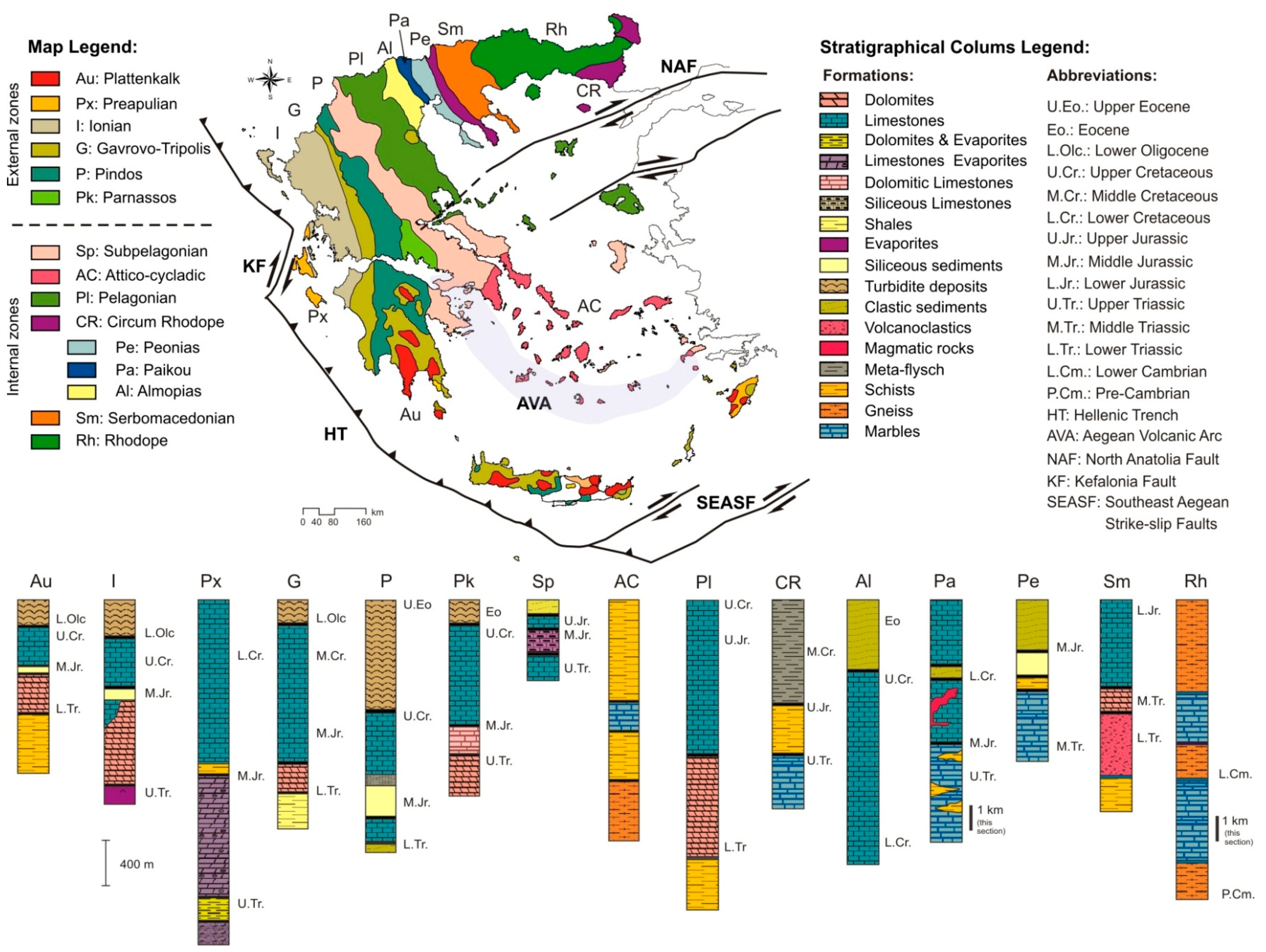
Figure 2.
Map showing the Hellenic karst systems (modified from [38]).
Figure 2.
Map showing the Hellenic karst systems (modified from [38]).
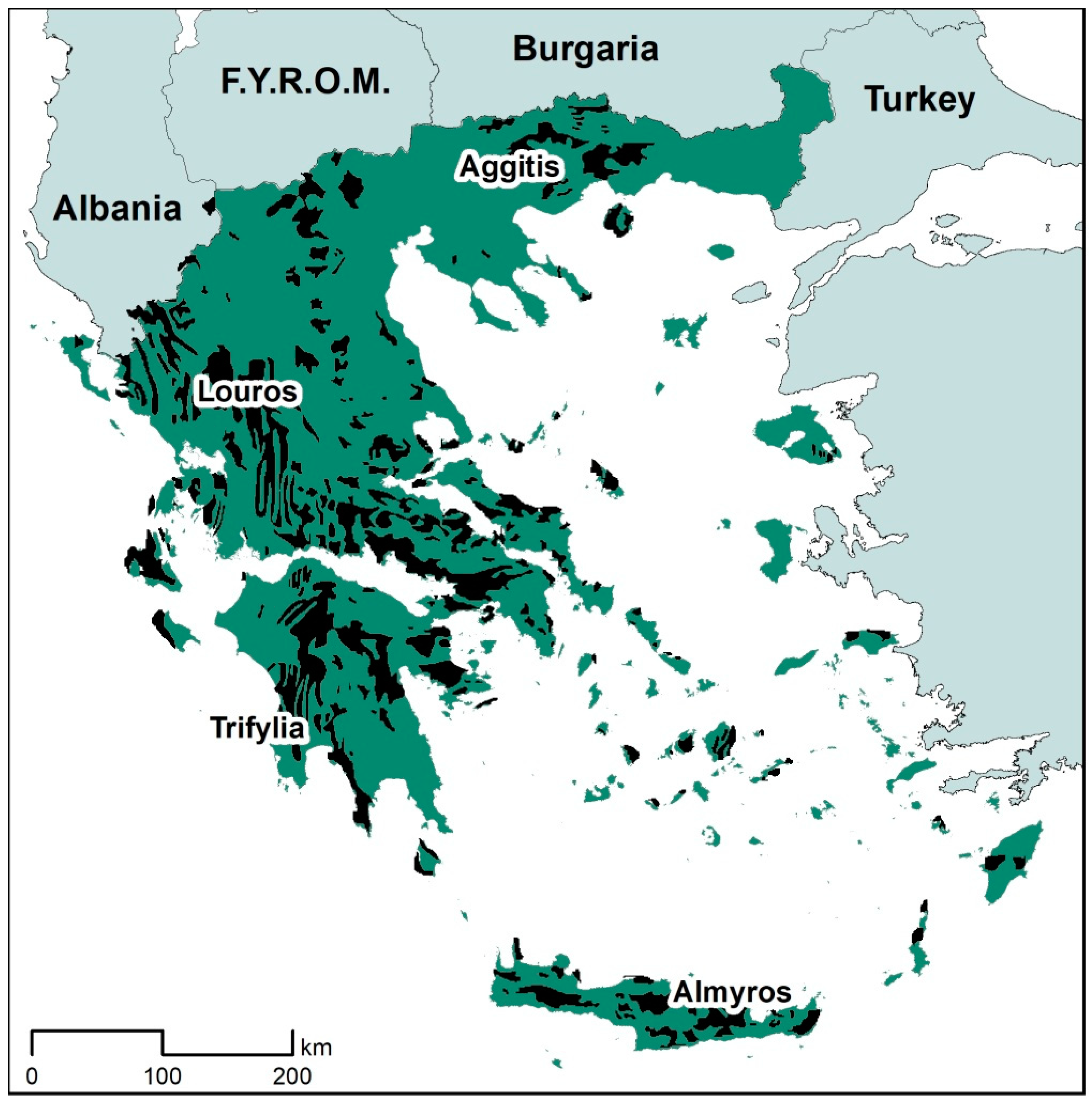
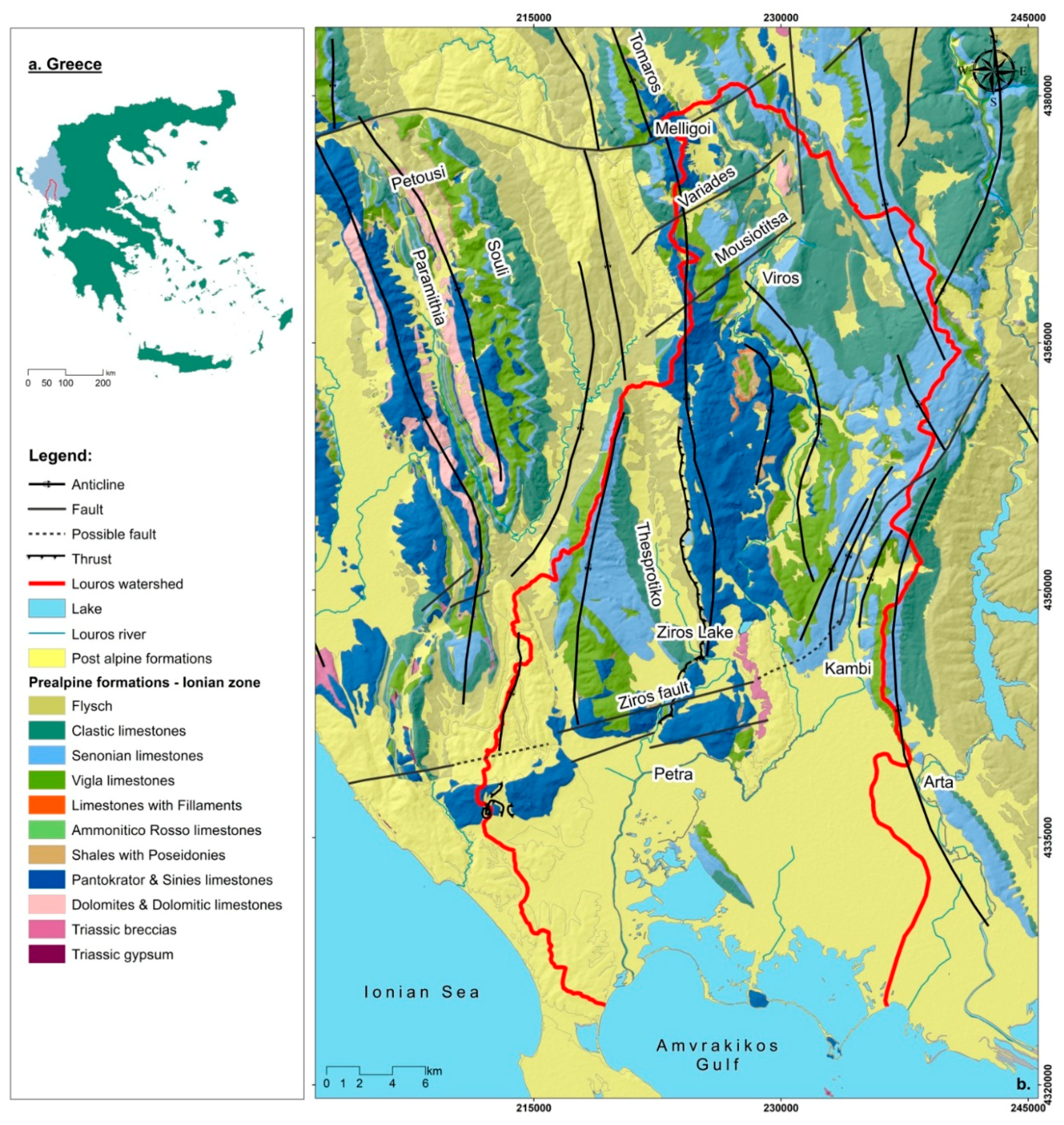
Figure 3.
Geological map of the study area [44].
Figure 3.
Geological map of the study area [44].

Figure 4.
The pie charts of THE microbial load along Louros Basin.
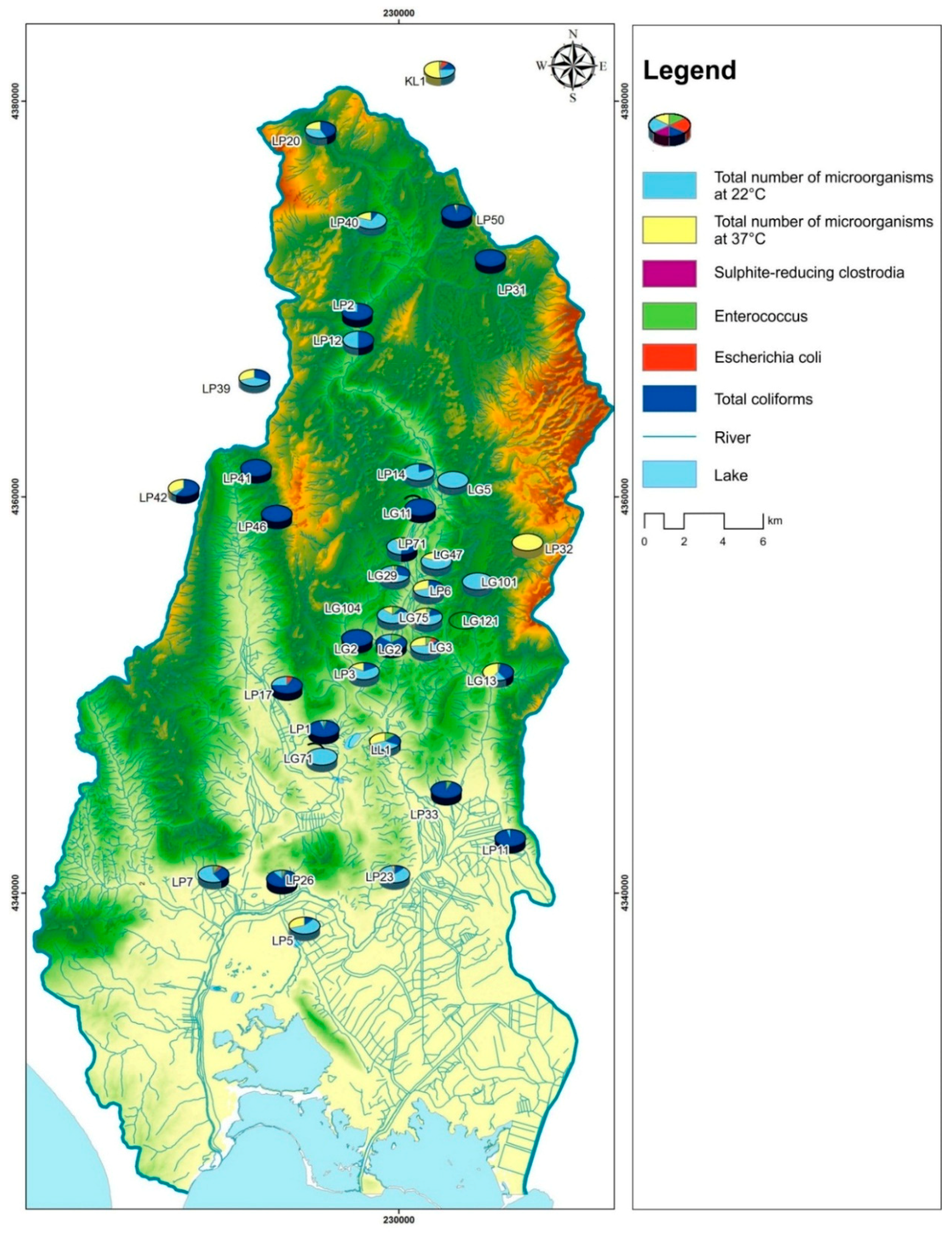
Figure 5.
Geographical distribution of a. the third, and b. the fourth factor in Louros Basin.

Table 1.
Rotation Sums of Squared Loadings.
| Total | % of Variance | Cumulative % |
|---|---|---|
| 1 | 2 | 3 |
| 6.412 | 42.745 | 42.745 |
| 2.299 | 15.328 | 58.073 |
| 1.530 | 10.202 | 68.275 |
| 1.274 | 8.496 | 76.770 |
Table 2.
Rotated Component Matrix.
| First Factor | Second Factor | Third Factor | Fouth Factor | |
|---|---|---|---|---|
| Twa | 0.802 | |||
| Eh | −0.527 | |||
| pH | −0.609 | |||
| HCO3 | 0.927 | |||
| K | 0.884 | |||
| Na | 0.946 | |||
| Mg | 0.952 | |||
| Ca | 0.847 | |||
| NH3 | 0.637 | |||
| NO3 | 0.686 | |||
| NO2 | 0.556 | |||
| SO4 | 0.893 | |||
| P | 0.935 | |||
| SiO2 | 0.559 | |||
| Cl | 0.958 |
© 2018 by the author. Licensee MDPI, Basel, Switzerland. This article is an open access article distributed under the terms and conditions of the Creative Commons Attribution (CC BY) license (http://creativecommons.org/licenses/by/4.0/).
Share and Cite
MDPI and ACS Style
Katsanou, K. Hellenic Karst Aquifers Vulnerability Approach Using Factor Analysis: The Example of the Louros Karst Aquifers. Geosciences 2018, 8, 417. https://doi.org/10.3390/geosciences8110417
AMA Style
Katsanou K. Hellenic Karst Aquifers Vulnerability Approach Using Factor Analysis: The Example of the Louros Karst Aquifers. Geosciences. 2018; 8(11):417. https://doi.org/10.3390/geosciences8110417
Chicago/Turabian StyleKatsanou, Konstantina. 2018. "Hellenic Karst Aquifers Vulnerability Approach Using Factor Analysis: The Example of the Louros Karst Aquifers" Geosciences 8, no. 11: 417. https://doi.org/10.3390/geosciences8110417
Note that from the first issue of 2016, this journal uses article numbers instead of page numbers. See further details here.