

The Ortelius Incident in the Hinlopen Strait—A Case Study on How Satellite-Based AIS Can Support Search and Rescue Operations in Remote Waters


Abstract
1. Introduction
2. Materials and Methods
The Technology
3. Results
4. Discussion
5. Conclusions
Acknowledgments
Conflicts of Interest
References
- Ylvisåker, L.N. Slept til byen. 2016. Available online: http://svalbardposten.no/nyheter/slept-til-byen/19.7240 (accessed on 1 July 2017).
- The Governor of Svalbard. Ekspedisjonsskip Slept til Longyearbyen av Polarsyssel (Press Release). Available online: http://www.sysselmannen.no/Nyheter/Ekspedisjonsskip-slept-til-Longyearbyen-av-Polarsyssel-/ (accessed on 1 July 2017).
- Engås, C. Passasjerskip har motorhavari i Hinlopenstretet. Svalbardposten (Internet). 2016. Available online: http://svalbardposten.no/nyheter/passasjerskip-har-motorhavari-i-hinlopenstretet/19.7238 (accessed on 1 July 2017).
- International Maritime Organization. AIS transponders. Available online: http://www.imo.org/en/OurWork/Safety/Navigation/Pages/AIS.aspx (accessed on 1 July 2017).
- Arctic Council. Agreement on cooperation on aeronautical and maritime search and rescue in the Arctic. In Proceedings of the Ministerial Meeting, Nuuk, Greenland, 12 May 2011. [Google Scholar]
- Aase, J.G.; Jabour, J. Can monitoring maritime activities in the European High Arctic by satellite-based Automatic Identification System enhance polar search and rescue? Polar J. 2015, 5, 1–17. [Google Scholar] [CrossRef] [Scilit]
- Norwegian Space Centre. Norway’s Satellites. Available online: http://www.romsenter.no/eng/Norway-in-Space/Norway-s-Satellites (accessed on 24 April 2017).
- AISSat-1 Satellite Details. Available online: http://www.n2yo.com/satellite/?s=36797 (accessed on 24 April 2017).
- ITU. Technical Characteristics for an Automatic Identification System Using Time Division Multiple Access in the VHF Maritime Mobile Frequency Band; ITU: Geneva, Switzerland, 2014. [Google Scholar]
- Clazzer, A.M.; Berioli, M.; Lazaro Blasco, F. On the Characterization of AIS Traffic at the Satellite 2014:(1 p.). Available online: https://login.ezproxy.utas.edu.au/login?url=http://search.ebscohost.com/login.aspx?direct=true&db=edseee&AN=edseee.6964425&site=eds-live (accessed on 2 July 2017).
- Shelmerdine, R.L. Teasing out the detail: How our understanding of marine AIS data can better inform industries, developments, and planning. Mar Policy 2015, 54, 17–25. [Google Scholar] [CrossRef] [Scilit]
- Security NC-USDoH. Types of AIS Updated 10/21/2015. Available online: http://www.navcen.uscg.gov/?pageName=typesAIS (accessed on 1 July 2017).
- Security NC-USDoH. Class A AIS Position Reports (Messages 1, 2 and 3) Updated 09/12/2014. Available online: http://www.navcen.uscg.gov/?pageName=AISMessagesA (accessed on 1 July 2017).
- International Maritime Organization. International Code for Ships Operating in Polar Waters (Polar Code); International Maritime Organization: London, UK, 2014. [Google Scholar]
- English, J.; Hewitt, R.; Power, D.; Tunaley, J. (Eds.) ICE-SAIS—Space-based AIS and SAR for improved Ship and Iceberg Monitoring. In Proceedings of the 2013 IEEE Radar Conference (RadarCon13), Ottawa, ON, Canada, 29 April–3 May 2013. [Google Scholar]
- SINTEF. Analysis of Maritime Safety Management in the High North (MARSAFE); SINTEF: Trondheim, Norway, 2010. [Google Scholar]
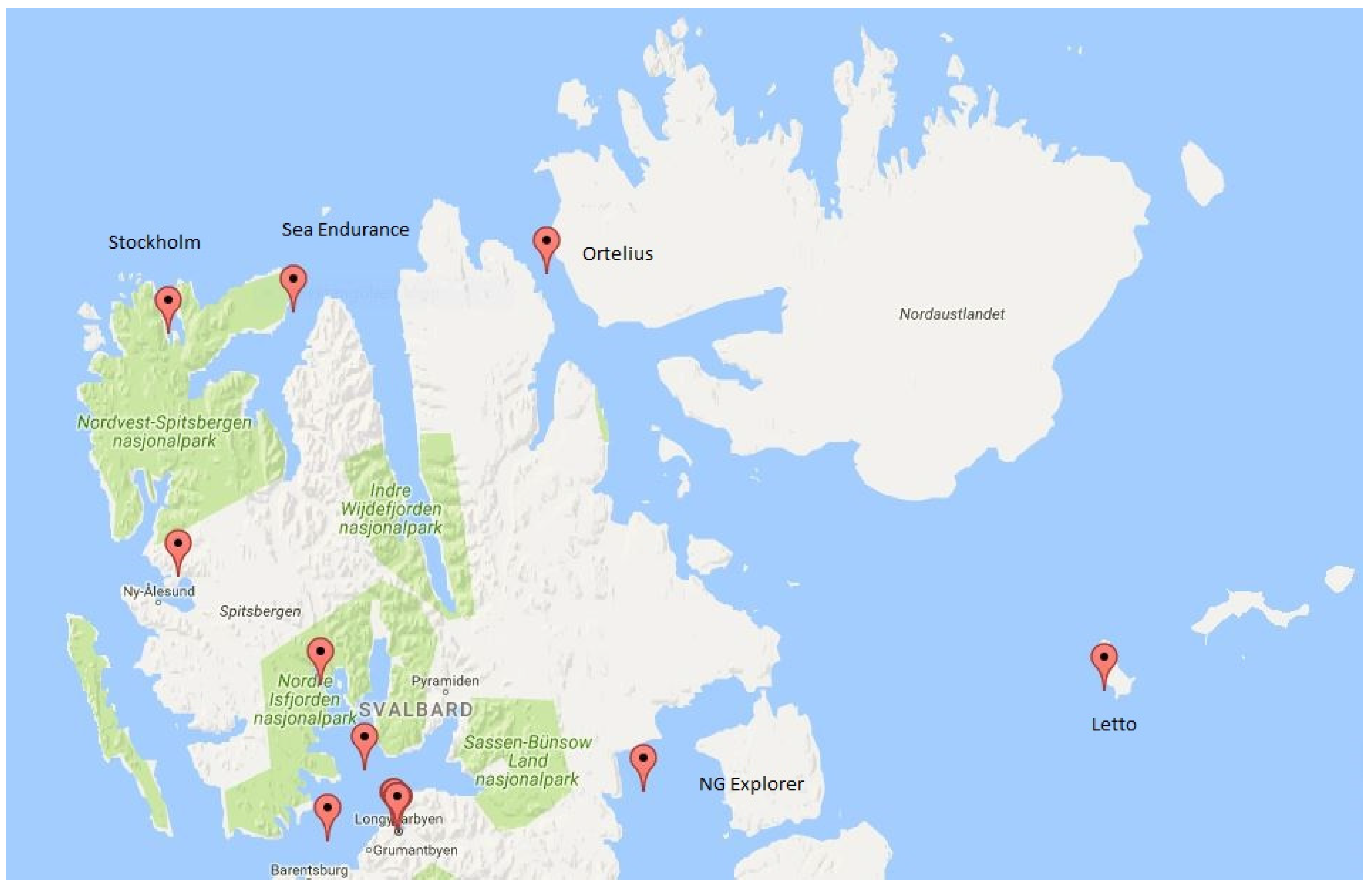
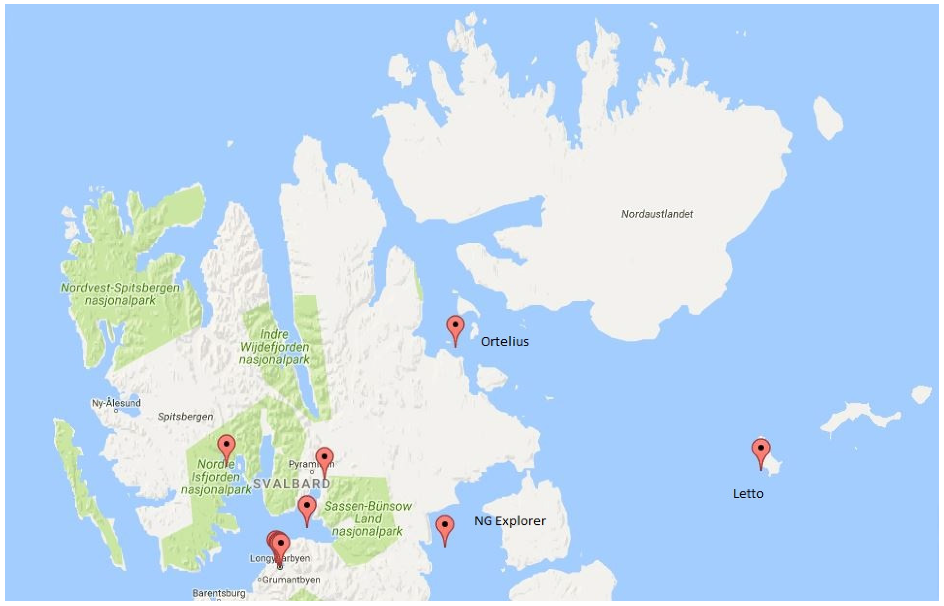
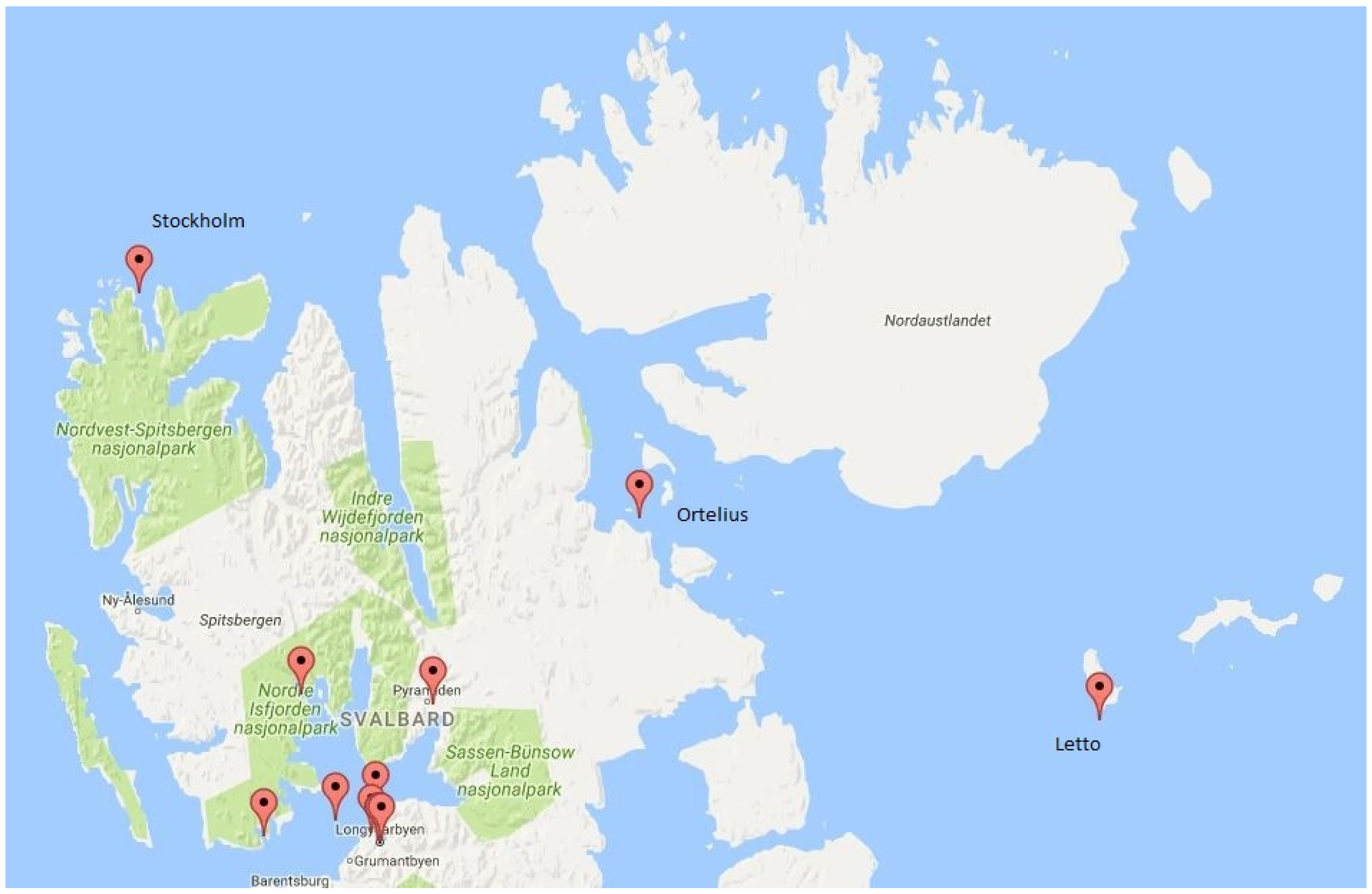

| Ground Time (J2000-Format) | Ground Time (UTC) | Number of Class A Transponders | Number of Class B Transponders |
|---|---|---|---|
| 518210407 | 07:19:03 | 17 | 0 |
| 518216384 | 08:58:40 | 19 | 0 |
| 518222190 | 10:35:26 | 17 | 0 |
| 518227993 | 12:12:11 | 15 | 0 |
| 518233702 | 13:47:20 | 14 | 3 |
| 518239380 | 15:21:57 | 15 | 0 |
| 518245043 | 16:56:19 | 15 | 2 |
| 518250739 | 18:31:15 | 15 | 0 |
| 518256482 | 20:06:58 | 10 | 0 |
| 518262252 | 21:43:08 | 16 | 0 |
| 518268049 | 23:19:45 | 15 | 1 |
| 518273856 | 00:56:32 | 13 | 0 |
| J2000 Time | Ground Time | MMSI | Ship Name | Latitude (° N) | Longitude (° E) |
|---|---|---|---|---|---|
| 518197774 | 518216384 | 257716000 | Norvarg | 78.194901667 | 14.518225 |
| 518197769 | 518216384 | 257785000 | Norbjorn | 78.2271 | 15.626295 |
| 518197743 | 518216384 | 258499000 | Polargirl | 78.228463333 | 15.607216667 |
| 518197769 | 518216384 | 259383000 | Kvalstein | 78.415078333 | 15.091848333 |
| 518197716 | 518216384 | 308198000 | Sea Endurance | 79.755633333 | 14.0061 |
| 518197797 | 518216385 | 209778000 | Ortelius | 79.857116667 | 17.901213333 |
| 518197874 | 518216385 | 228016600 | Polaris I | 79.000926667 | 12.226958333 |
| 518197813 | 518216385 | 231219000 | Billefjord | 78.228133333 | 15.609723333 |
| 518197966 | 518216385 | 257564000 | Polarsyssel | 78.243046667 | 15.542806667 |
| 518197919 | 518216385 | 257958900 | Elling Carlsen | 78.228358333 | 15.607108333 |
| 518197813 | 518216385 | 258301500 | Longyear 2 | 78.229455 | 15.595758333 |
| 518197808 | 518216385 | 265339000 | Origo | 78.675666667 | 14.424033333 |
| 518197969 | 518216385 | 265472000 | Stockholm | 79.694685 | 12.072846667 |
| 518197840 | 518216385 | 265511830 | Malmo | 78.228395 | 15.63347 |
| 518197817 | 518216385 | 309336000 | NG Explorer | 78.349136667 | 19.403083333 |
| 518203825 | 518216386 | 230359000 | Letto | 78.66142 | 26.515886667 |
| 518203679 | 518216386 | 246337000 | Antigua | 78.229641667 | 15.599933333 |
| 518203756 | 518216386 | 259560000 | Aurora Explorer | 78.228448333 | 15.606318333 |
| 518215390 | 518216388 | 982575641 | Munin | 78.243265 | 15.545936667 |
| J2000 Time | Ground Time | MMSI | Ship Name | Latitude (° N) | Longitude (° E) |
|---|---|---|---|---|---|
| 518215514 | 518222190 | 231219000 | Billefjord | 78.40383 | 16.231346667 |
| 518215513 | 518222190 | 257716000 | Norvarg | 78.234521667 | 15.58116 |
| 518215513 | 518222190 | 258301500 | Longyear 2 | 78.229436667 | 15.595971667 |
| 518215515 | 518222190 | 259383000 | Kvalstein | 78.238475 | 15.600005 |
| 518215514 | 518222190 | 265339000 | Origo | 78.6755 | 14.423383333 |
| 518215514 | 518222190 | 309336000 | NG Explorer | 78.312518333 | 19.353716667 |
| 518215520 | 518222190 | 982575641 | Munin | 78.24277 | 15.543858333 |
| 518221167 | 518222192 | 209778000 | Ortelius | 79.195583333 | 19.60105 |
| 518221271 | 518222192 | 230359000 | Letto | 78.661575 | 26.517788333 |
| 518221264 | 518222192 | 231219000 | Billefjord | 78.621325 | 16.639601667 |
| 518221318 | 518222192 | 246337000 | Antigua | 78.229663333 | 15.600031667 |
| 518221376 | 518222192 | 257958900 | Elling Carlsen | 78.228355 | 15.60712 |
| 518221283 | 518222192 | 258499000 | Polargirl | 78.228463333 | 15.607218333 |
| 518221340 | 518222192 | 265511830 | Malmo | 78.228398333 | 15.633618333 |
| J2000 Time | Ground Time | MMSI | Ship Name | Latitude (° N) | Longitude (° E) |
|---|---|---|---|---|---|
| 518221298 | 518227993 | 265339000 | Origo | 78.675481667 | 14.423423333 |
| 518226957 | 518227995 | 209778000 | Ortelius | 79.195453333 | 19.60193 |
| 518227003 | 518227995 | 230359000 | Letto | 78.59905 | 26.655235 |
| 518227003 | 518227995 | 231219000 | Billefjord | 78.64916 | 16.435135 |
| 518227078 | 518227995 | 246337000 | Antigua | 78.229676667 | 15.599943333 |
| 518227021 | 518227995 | 257564000 | Polarsyssel | 78.257716667 | 15.496866667 |
| 518227078 | 518227995 | 257785000 | Norbjorn | 78.227035 | 15.626483333 |
| 518227136 | 518227995 | 257958900 | Elling Carlsen | 78.228366667 | 15.607118333 |
| 518227103 | 518227995 | 258301500 | Longyear 2 | 78.229458333 | 15.59592 |
| 518227122 | 518227995 | 258499000 | Polargirl | 78.228461667 | 15.607258333 |
| 518226988 | 518227995 | 259383000 | Kvalstein | 78.290006667 | 14.942508333 |
| 518227008 | 518227995 | 259560000 | Aurora Explorer | 78.327628333 | 15.561741667 |
| 518226971 | 518227995 | 265472000 | Stockholm | 79.824723333 | 11.941258333 |
| 518227261 | 518227995 | 265509140 | Freya | 78.243206667 | 13.846441667 |
| 518227120 | 518227995 | 265511830 | Malmo | 78.228373333 | 15.633635 |
© 2017 by the author. Licensee MDPI, Basel, Switzerland. This article is an open access article distributed under the terms and conditions of the Creative Commons Attribution (CC BY) license (http://creativecommons.org/licenses/by/4.0/).
Share and Cite
Aase, J.G. The Ortelius Incident in the Hinlopen Strait—A Case Study on How Satellite-Based AIS Can Support Search and Rescue Operations in Remote Waters. Resources 2017, 6, 35. https://doi.org/10.3390/resources6030035
Aase JG. The Ortelius Incident in the Hinlopen Strait—A Case Study on How Satellite-Based AIS Can Support Search and Rescue Operations in Remote Waters. Resources. 2017; 6(3):35. https://doi.org/10.3390/resources6030035
Chicago/Turabian StyleAase, Johnny Grøneng. 2017. "The Ortelius Incident in the Hinlopen Strait—A Case Study on How Satellite-Based AIS Can Support Search and Rescue Operations in Remote Waters" Resources 6, no. 3: 35. https://doi.org/10.3390/resources6030035
APA StyleAase, J. G. (2017). The Ortelius Incident in the Hinlopen Strait—A Case Study on How Satellite-Based AIS Can Support Search and Rescue Operations in Remote Waters. Resources, 6(3), 35. https://doi.org/10.3390/resources6030035

