Article

An Urban “Mixity”: Spatial Dynamics of Social Interactions and Human Behaviors in the Abese informal Quarter of La Dadekotopon, Ghana

1
Division of Global Architecture, Graduate School of Engineering, Osaka University, Yamadaoka, Suita 560-0871, Osaka, Japan
2
School of Planning, College of DAAP, University of Cincinnati, P.O. Box 210016, Cincinnati, OH 45221, USA
3
Center for Urban Planning and Policy Analysis (CUPPA), P. O. Box KS 8869, Adum-Kumasi, Ghana
*
Author to whom correspondence should be addressed.
Urban Sci. 2017, 1(2), 13; https://doi.org/10.3390/urbansci1020013
Submission received: 30 January 2017 / Revised: 8 April 2017 / Accepted: 11 April 2017 / Published: 14 April 2017

Abstract

:
Informal settlements form part of the socio-spatial landscape of urban areas. Yet little is known about their spatial aspects, compared to the social aspects. With global attention on sustainable cities and inclusive urban planning, there is a need to pay attention to the spatial dynamics of human behavior and interactions as they have ramifications for the sustainable planning and design of informal spaces. Using observation and mapping, this paper emphasizes the spatial dynamics of social interactions and human behavior in the indigenous settlement of the Abese quarter of La Dadekotopon, Ghana. Spatially, the study identifies a hierarchical, irregular, and open system of roads and alleys that support residents’ everyday life. An “urban mixity” pattern of human behavior exists in the quarter, which denotes the social and physical use of informal urban spaces by residents to fulfill different needs at various times of the day. This creates lively urban spaces within the quarter. The location and physical characteristics, microclimate, and residents’ needs have contributed to this kind of informal urban spaces. This paper argues for planning and design improvement that integrate, rather than supplant, existing local physical characteristics, social interactions and human behaviors to maintain local identity and sustain urban life.

1. Introduction

Informal settlements represent a salient feature in the socio-spatial organization of cities and major towns in Ghana [1,2]. In the Greater Accra Metropolitan Area (GAMA) (the capital area) alone, about 60 percent of the population resides in informal settlements [3,4,5,6], which is higher than the national average of 37.9 percent [7]. For local authorities, informal settlements are characterized by a lack of land tenure, poor housing conditions and inadequate access to basic housing and community facilities and services [8,9]. From these defining characteristics, about 78 settlements in the GAMA are considered to be informal settlements and require necessary improvements in physical, social, environmental and economic conditions [8].
The Abese quarter, in the La Dadekotopon Municipality of GAMA, the focus of this paper, is considered to be an urban informal settlement. This quarter, in addition to seven other quarters, constitutes the historical core of the La Township [10,11,12]. Unlike squatter or migrant informal settlements in the Municipality, this area is an indigenous quarter composed of natives with strong ethnic, social and cultural practices. The quarter is in one of the relatively wealthy, cosmopolitan, and rapidly-modernizing districts in Ghana [10]. However, residents identify and differentiate themselves from other settlements by exercising distinct spatial, social, and cultural practices. Residents collectively build on indigenous socio-cultural systems to adapt to their physical environment spanning hundreds of years [12]. Unfortunately, the spatial aspects of indigenous informal settlements, their residents’ behavioral activities and socially embedded systems have not been profoundly studied so far.
Research on residents’ social collaboration and activities in Abese quarter provides an entry point for this research [12]. Still focusing on the social organization and dimensions of residents, this study aims to understand the spatial dynamics of human behavior and social interactions that are part of residents’ daily urban experiences. This quarter is not threatened by concerns of continuity and sustainability of local life [11,12] when compared with other areas that are rapidly deteriorating and losing their core identities in the Municipality. Thus, focusing on spatial dynamics offers the possibility of understanding how residents’ behaviors, as well as their interactions, manifest spatially. In this paper we consider specifically the social interactions and human behaviors that emanate alongside social collaboration and residents’ collective activities in urban informal settlements [12]. This is critical for learning lessons for the undoing of the modernist-planning ethos of supplanting indigenous African practices in the built environment [13], which currently persists in several parts of the Municipality. Again, such a perspective provides an opportunity for the adoption of an “outside-in” approach [14] to urban planning, where such local spatial dynamics are not marginalized, but are integrated into local planning practice. This serves as a springboard for heeding the call for planning initiatives to be contextualized to account for local conditions [13].
Beginning from the early 2000s, there have been some studies on the socio-spatial conditions [2,5,6,15,16], housing [17], political economy and globalization [18,19,20] processes at play in urban informal settlements in GAMA. Specifically, some studies have focused on the physical conditions and characteristics of houses in Accra related to poor housing conditions, compound-type family houses and the trend towards single detached housing [17]. One study drew on anthropological perspectives to examine the history and spatial formation in low-income migrant settlements within GAMA with an emphasis on historical processes, leadership and community development [5]. Another touched on the poor health and environmental conditions in informal settlements [15], while others examined the effect of globalization and neoliberal processes on the perpetuation of urban informal settlements in GAMA [18,19,20]. Residents’ improvisations in obtaining access to basic infrastructure, such as electricity, have also been studied [2,12], with recent studies revealing a self-organization trait among informal settlement dwellers in the provision of basic amenities [12,16]. This diversity of empirical studies provides an enriching understanding of characteristics, conditions, practices and, until recently, the positive impact of resident collective practices in informal settlements.
Nonetheless, little is known about the spatial dynamics of social interactions and human behavior in indigenous informal settlements in GAMA. Also, there is, surprisingly, a limited use of spatial organization analysis in understanding indigenous urban informal settlements [21,22]. Such an approach focuses on the spatial dynamics of places by examining relationships between human behavior and their physical environment [23,24], the physical characteristics of a place that facilitate specific uses [25], and the “mixture of processes that create our experience of our socio-physical surroundings” [26] (p. 118). Through spatial organization analysis, it is possible to understand the intersections between social and physical factors as well as how informal settlers insert activities and practices into space to deal with their daily urban challenges. For instance, spatial organization analysis has been used to identify the distribution, structure, and residents’ use of streets, in order to evaluate spatial patterns in old quarters [27]. It has also been used to physically demarcate street space and compound houses to examine the relationship between people and urban space in migrant communities [22]. More recently, scholars have used it to map the physical layout and characteristics of houses to understand living environments in traditional urban districts [28].
This paper contributes to existing research on urban informal settlements by focusing on social interactions and human behavior and their spatial aspects in the indigenous informal quarter of Abese, in La Dadekotopon Municipality of GAMA. This native quarter, with a distinct spatial organization and social structure, has not received much attention in scholarly research, compared to other informal areas in GAMA. To proceed, we are guided by the observation that cities in Africa are both spatially-delineated and culturally-differentiated quarters [21]. This implies that the different informal quarters of the city with similar features cannot be subsumed within a single universal nomenclature for informal settlements. Thus, through a spatial organizational analysis of social interactions and human behavior, it is possible to identify the distinctiveness of urban informal quarters, their ordering in space, and practices, to understand the urban milieu. It also offers the opportunity to gain insights into practical ways of contextualized community-led planning and design improvement in existing conditions.
The paper is organized into six main sections. The methodology for the study, captured under the materials and methods, follows the brief review of informal settlements, human behavior and the notion of “mixity”. The fourth part focuses on the results of the study, which is followed by a discussion of the findings. The paper concludes with implications and hints for the future improvement of conditions in the Abese quarter and urban informal settlements.

2. Informal Settlements, Human Behavior and Mixity

Since the second half of the 20th century, the informal sector has been conventionally conceived as the opposite of the formal sector in a dualistic framework (formal/informal) for analyzing economic activities in developing countries [29,30]. Rooted in economic anthropology and development economics, there was a general recognition that the state of developing economies was largely informal, and would become imperceptible if not considered [31]. The informal sector, therefore, came to represent activities and functions that existed outside of the state and occurred without a system of organization [9]. This narrative eventually led to the association of informality with illegality, spontaneity, and disorganization [32]. In spite of its popularity within international development circles [33], this view has since been contested within urban scholarship, leading to various propositions to underscore the multiple dimensions of informality: economic, social, behavioral, sustainability and even governance [34,35,36,37].
The behavioral perspectives are expressed in terms of individual and collective activities and practices, both within and outside state norms or regulation [37,38]. It conceptualizes the human agency of “informal settlements”. Since individual and collective behaviors within a space are interwoven between a set of social, economic and territorial factors [39], informal settlements become a “spatializing” application of the concept of informality [9,40]. In this vein, informal settlements represent behavior and condition, describing identifiable parts of a space, developed without regard to state planning and laws. So, the general understanding is that conditions may be poor (e.g., bad shelter) and activities that underpin or result from such activities mark symbols of poverty [41]. Yet, recent studies have contested such claims as narrow—since they fail to underscore the dynamics and intricacies of formal-informal interdependencies and the “order” (of governance and service) that operates in the informal [38,42,43]. Indeed, the marginalization of the informal and emphasis on conditions [44] has led to brutal interventions like mass evictions [20,44,45]. Nonetheless, when informal housing, as produced through informal behavior, is considered as a verb [46]—that is, as a system of changing human/behavioral practices—it helps to comprehend the spatial dynamics and local needs rather than mere conditions and negative narratives [47].
This behavioral component can be better understood by employing Environmental Behavior Studies (EBS), which integrates human behavior and spatial dynamics. Within EBS, human behavior entails a set of individual and collective activities that occur due to interactions between people and their setting [23]. While the social component of this interaction relates to meetings and conversations between residents or neighbors [23], the setting, or behavior setting [48], refers to the physical layout, the human pattern and the relationship between them [48]. It is through this setting that human behavior and need—that is, the physical characteristics that allow for specific activities or uses to occur at specific places—is “afforded” [25]. The idea also includes patterns of human behavior to fulfill everyday purposes and the resources needed to support them [49]. But this process of fulfillment may also include “personalization”, where a group of individuals personalize aspects of space and condition it for social interaction [23]. However, it is the territorial flexibility and adaptability to different behaviors and needs that make this personalization of urban spaces possible [23]. Thus, in as much as physical layout and characteristics of space may simplify or complicate the setting, it is through territorial gestures, social interactions, and the sale of goods and services and leisure that the relationship with the physical context is clearly understood [50,51]. Either way, it is generally agreed that tracking human behavior provides one possibility for understanding the physical environment; for example, streets and public spaces and the comfort or anxiety that they afford. Thus, using direct observation (faculty of sight) and descriptive analysis, one can evaluate neighborhoods and their qualities to improve urban experiences by altering the design and physical aspects of settlements [52].
It is thus within this conceptualizing of human behavior and their spatial settings that the concept of “mixity” emerges. The term relates to indigenous urban tissue and the patterns of human behavior in urban space [53]. It also refers to a combination of social strata, functions (or activities) and economies. It denotes the observation of mixed activities that include different groups (or users), and the social and economic activities that occur within the indigenous (yet unplanned) or historical enclaves of an old city [53]. Mixity is functional and includes uses and activities within urban space that foster integration of uses and users rather than separation [54]. This is a quality that can promote the renewal of urban informal settlements; useful for understanding the social and economic “fate” that surround daily practices in informal settlements [54]. Mixity also includes the young and the old, their human behavior patterns in space, and their expression of everyday needs [55]. For the most part, scholars argue that mixity is not only a trend or phenomenon but also a planning and policy goal, which reflects the integration and functionality of urban places and spaces.
For the purposes of our work, human behavior entails individual or group activity observed through residents’ interaction with the physical configuration of space (spatial setting). Social interaction refers to activities or interactions between residents’ as part of observed human behavior. Urban mixity, therefore, represents different patterns of human behavior within a defined space, an integration of spaces, uses, and users. It is also a mechanism through which we can understand the relationships between social interactions and human behaviors, as well as human needs within a local spatial context.

3. Materials and Methods

3.1. Research Design

This paper was based on a case study design that employed observations and mapping of the physical aspects of an informal settlement in La Dadekotopon (Figure 1). This was conducted in November 2016. The designated case study area—the Abese quarter—is one of eight quarters that constitute the historical core (La Mami) of La Dadekotopon. There are fifteen of the seventy-seven historical clan houses in La Mami. The selection of the area is based on an earlier study into residents’ social collaborative and collective activities in the quarter [12] that provides an entry point to examine the spatial dynamics of the social interactions and human behaviors.
The data collected included different aspects, but this paper pays attention to three spatial dynamics: (i) spatial aspects of road networks; (ii) open spaces; and (iii) structure and social function of clan houses. In all three aspects, the central theme explored relates to social interactions and human behavior. This case study approach is grounded on the foundation that truth about cities must be conceived from the bottom up, located in the street or urban public space [56]. Thus, through this approach, we contribute to the socio-spatial discourse on urban informal settlements.

3.2. Data Collection Process

The data-collection process consisted of the following steps. First, we located and mapped important spatial components such as open spaces, alleys, clan houses, communal facilities, and shrines, on the basis of a Google map generated before the fieldwork. Without any existing map of the quarter, this was used to gain an initial understanding of spatial organization in the study area. Secondly, we measured the dimensions of open spaces, alleys and clan houses to grasp their distribution in space and observed their conditions and uses. In each of the open spaces, with the “faculty of sight”, we observed (i) the interactions between the residents and the physical configuration of selected informal open spaces (human behavior); and (ii) interactions among residents within observed human behavior (social interaction), to ascertain the uses of space in the morning, afternoon and evening. This study was carried out during weekdays from Monday to Friday, since residents usually stayed in the various clan houses during weekends for family meetings. Thirdly, we conducted a non-participant observation in two community meetings to understand the social and cultural mechanisms that support the physical and spatial aspects of the quarter. All the data obtained was collated thematically, using maps and excel sheet to organize them in line with the focus of the study.

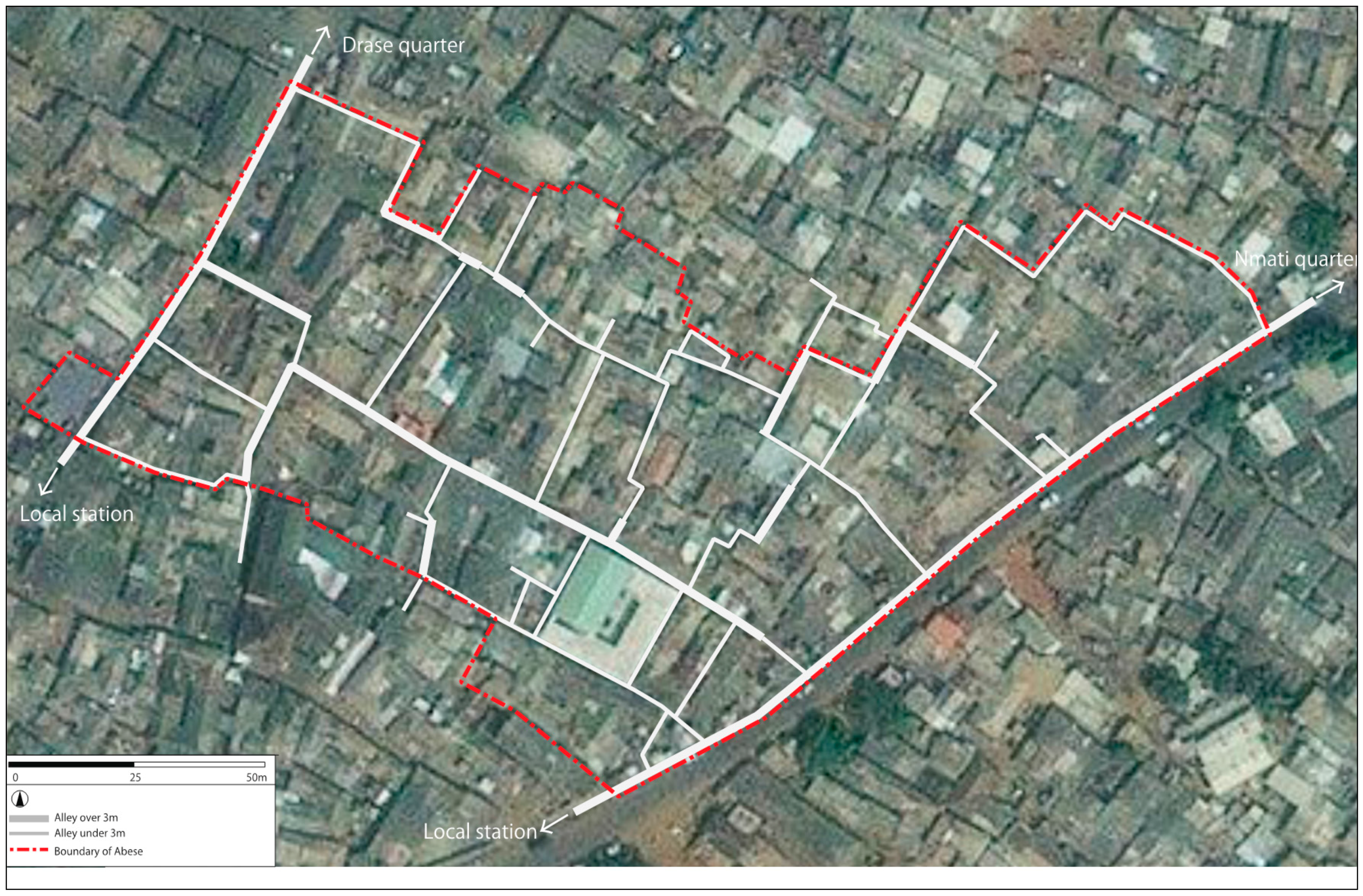
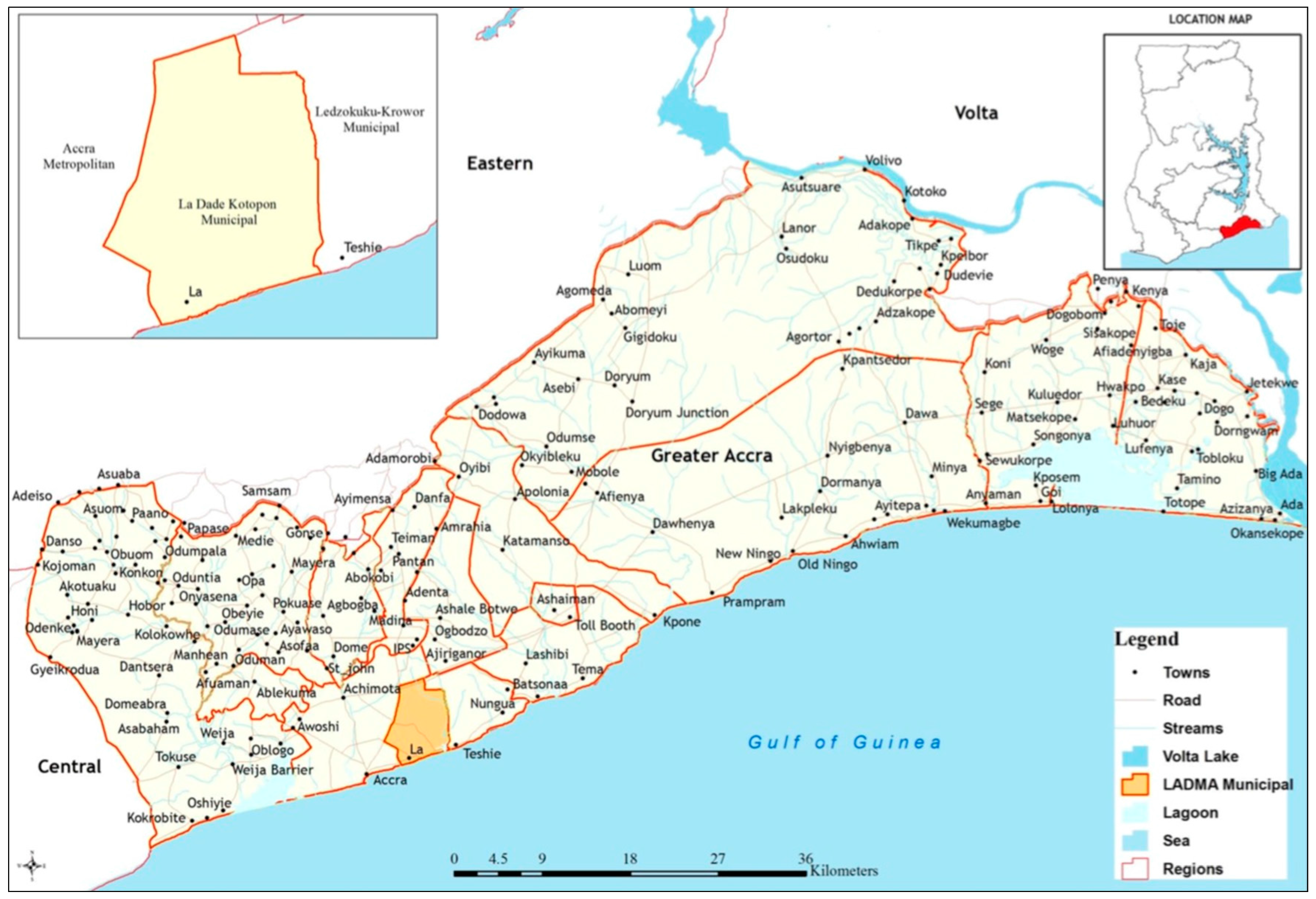
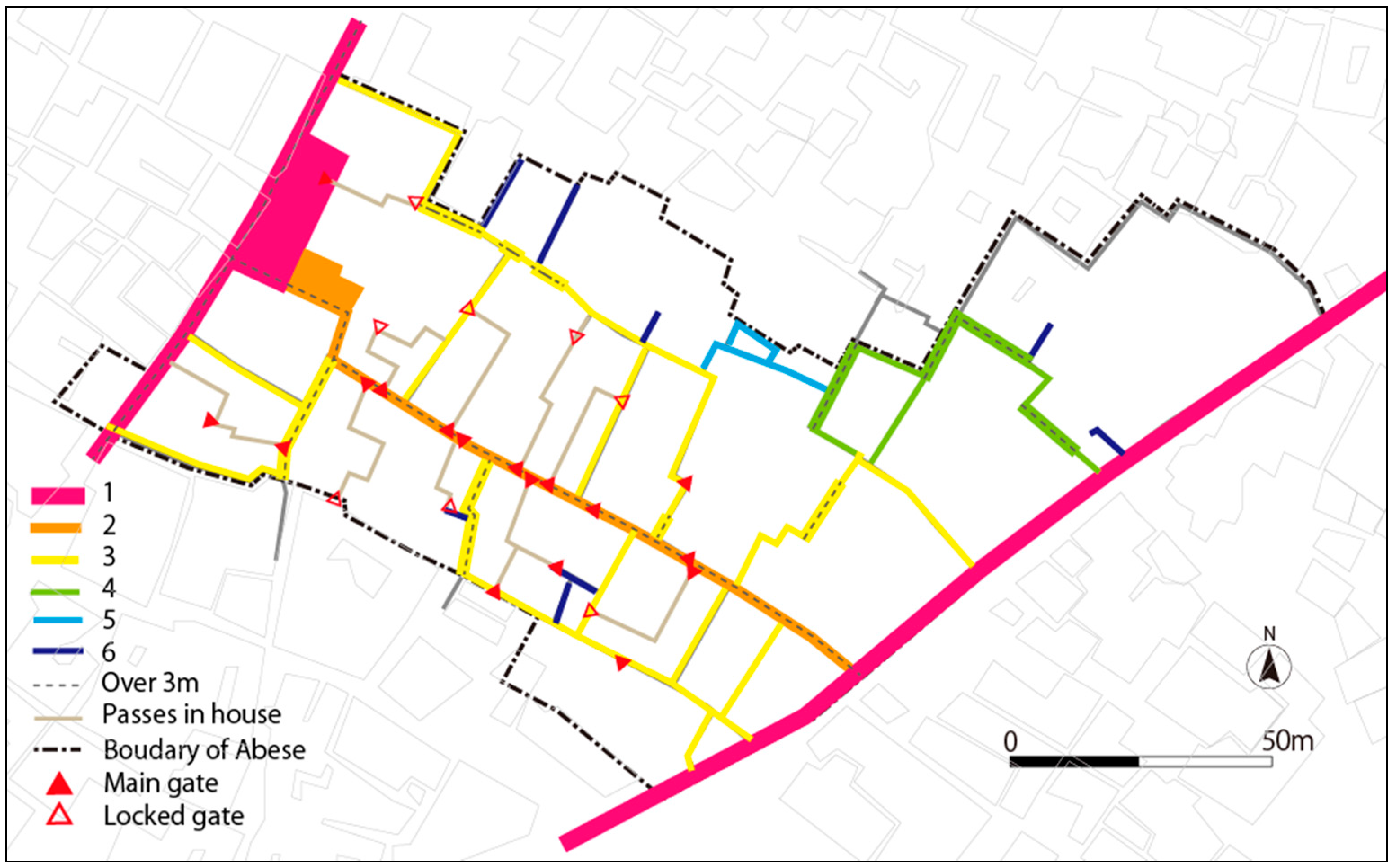
3.3. Description of the Study Area—The Abese Quarter

The Abese quarter is located in the La Dadekotopon Municipality, one of the 12 districts in the Greater Accra Metropolitan Area of Ghana. This quarter, also known as Abese Division, is one of the eight quarters, which constitute the historical native enclave of La Dadekotopon [11]. The quarter is approximately 450 m from the La road—across the coast. Neighboring settlements include Kowe, Abafum and Dzrase. At the district level, the site is located between the Accra Metropolitan Assembly (AMA) to the North-West, Ledzorkuku-Krowo (LEKMA) to the East, and the Gulf of Guinea to the South (Figure 1).
Native inhabitants belong to the La peoples who migrated from Egypt in the 15th century BC through Bone in Nigeria. Historically, the settlement is traceable to a successive process of westward migration from the East (Bone) at different, convenient periods. This included the crossing of the Volta River with other Ga-Adamgbe tribes, in the following order: Krobo, Ada, Ga-Mashie, Osudoku, Shai and La peoples [57]. As the last in the order of westward migration, the La people’s present territory—between Osu and Nungua—was secured through inter/intra-ethnic wars and alliances. The site of Abese was established around the 17th century through an agreement between La and Osu traditional leadership [57]. Under the custodianship of La traditional leaders, the land was distributed among settlers along clan lines. The heads of the clans and the divisional chief therefore exercise significant power in land, housing and physical development matters [12,58]. As elsewhere in Greater Accra, the settlement was predominantly a fishing and farming village in the precolonial era [3]. Houses were built of mud and thatch, with social customs, traditions, and culture influencing the building layouts and spatial organization of the quarter [12].
The physical form of the settlement is irregular, and is defined by a network of alleys that connects the various clan houses (Figure 2). Traditional single-story courtyard-based family houses constitute the main building pattern [10,11]. From the original nucleus of 15 clan houses, increases in population have led to individual self-built housing without planning regulation or basic housing facilities [12]. However, the Abese quarter is considered to be informal, but not illegal, settlement [8].
Broadly, the development of the quarter is embedded within changes in La Dadekotopon and the city of Accra generally. For instance, the relocation of the capital of the then-Gold Coast (now Ghana) to Accra in 1877 [3], and its function as a central business district, pulled some of the inhabitants formerly involved in agriculture to work at the port and central market [19,57]. More recently, it has been noted that unscrupulous sales of agricultural land for real estate development in La Dadekotopon have driven most of the inhabitants in the area, including Abese, into informal economic activities such as food vending and transportation services within Accra central [11,45]. The nearby transport terminal has turned into an economic center for men and women who work as mini bus conductors and food vendors respectively [10]. Thus, the Abese quarter, like many others in the Municipality and GAMA, is characterized by informal activities.
Administratively, the Abese quarter was part of the La sub-metropolitan council of the Accra Metropolitan Assembly (AMA) until 2012. However, in 2012, the La sub-metropolitan council was carved out of the AMA to establish the La Dadekotopon Municipal Assembly [58]. The Abese quarter, in addition to Kowe, subsequently became an electoral area with an elected assembly member to represent the two communities in the municipal assembly. The “presence” [59] of La Dadekotopon municipality, as an urban state in the Abese quarter, is perhaps most clearly manifested in the community showers and sewers provided recently to improve conditions in the quarter [12].

4. Results

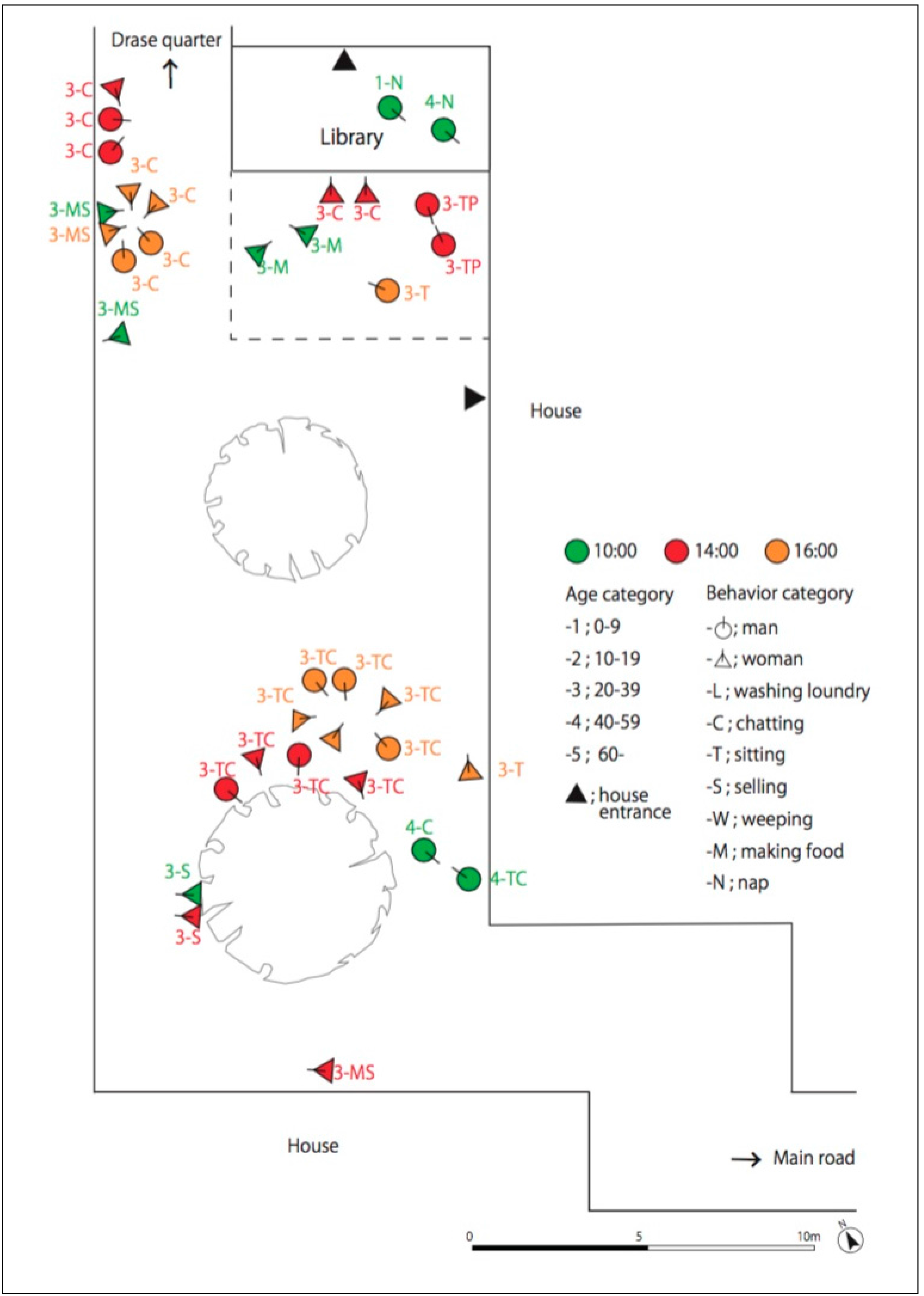
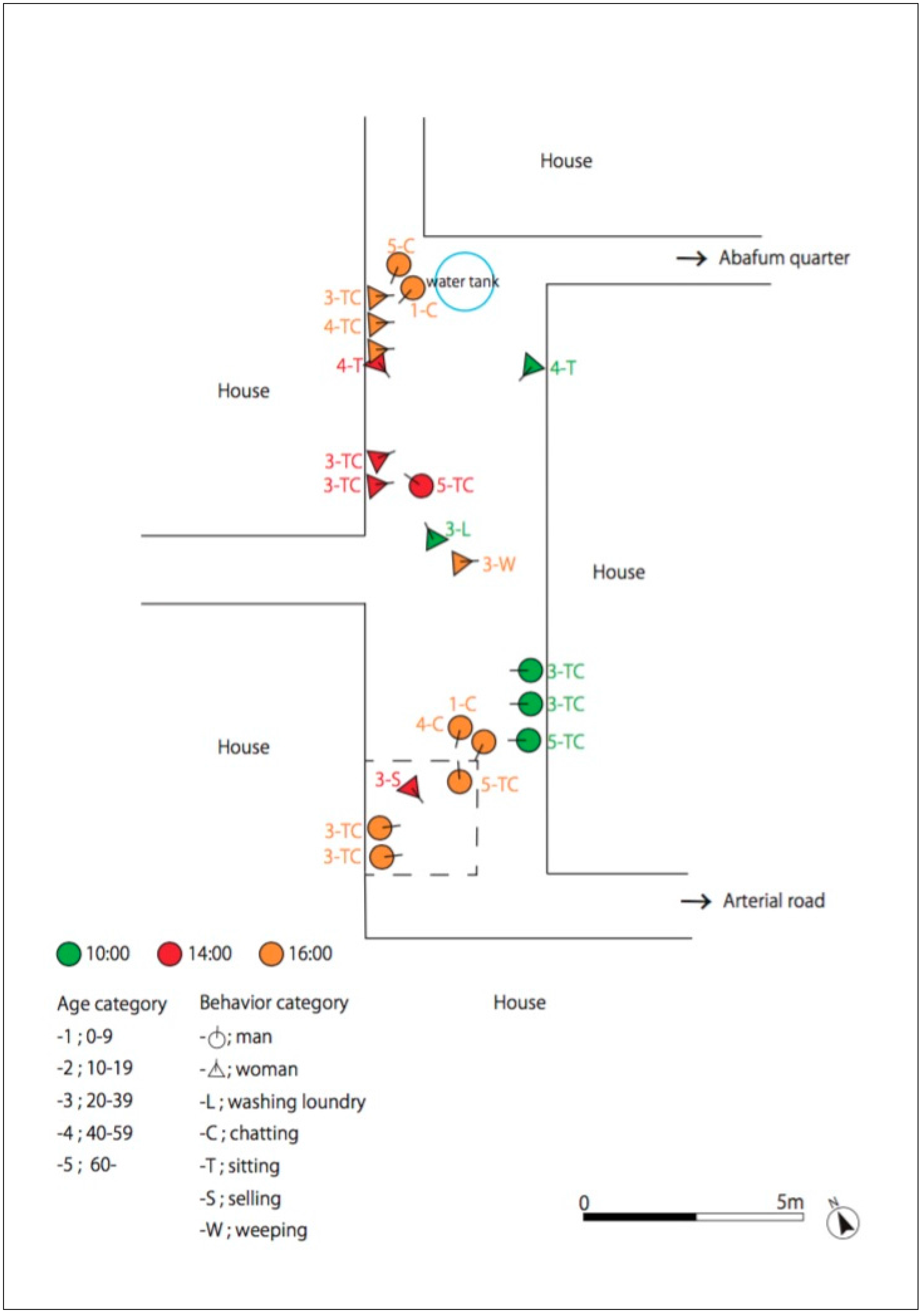
4.1. Spatial Dynamics of Social Interactions and Human Behavior in the Abese Quarter

This section examines the spatial dynamics based on the social functions of clan houses, distribution and hierarchy of roads, as well as social interactions and human behavior in open spaces in the quarter. As noted earlier, human behavior here is conceived as the result of the interactions between residents and the selected open spaces in the study area, observed in terms of their activities to meet their needs in open space. Thus, we examine how these physical spaces relate to social interactions and human behavior in the quarter.

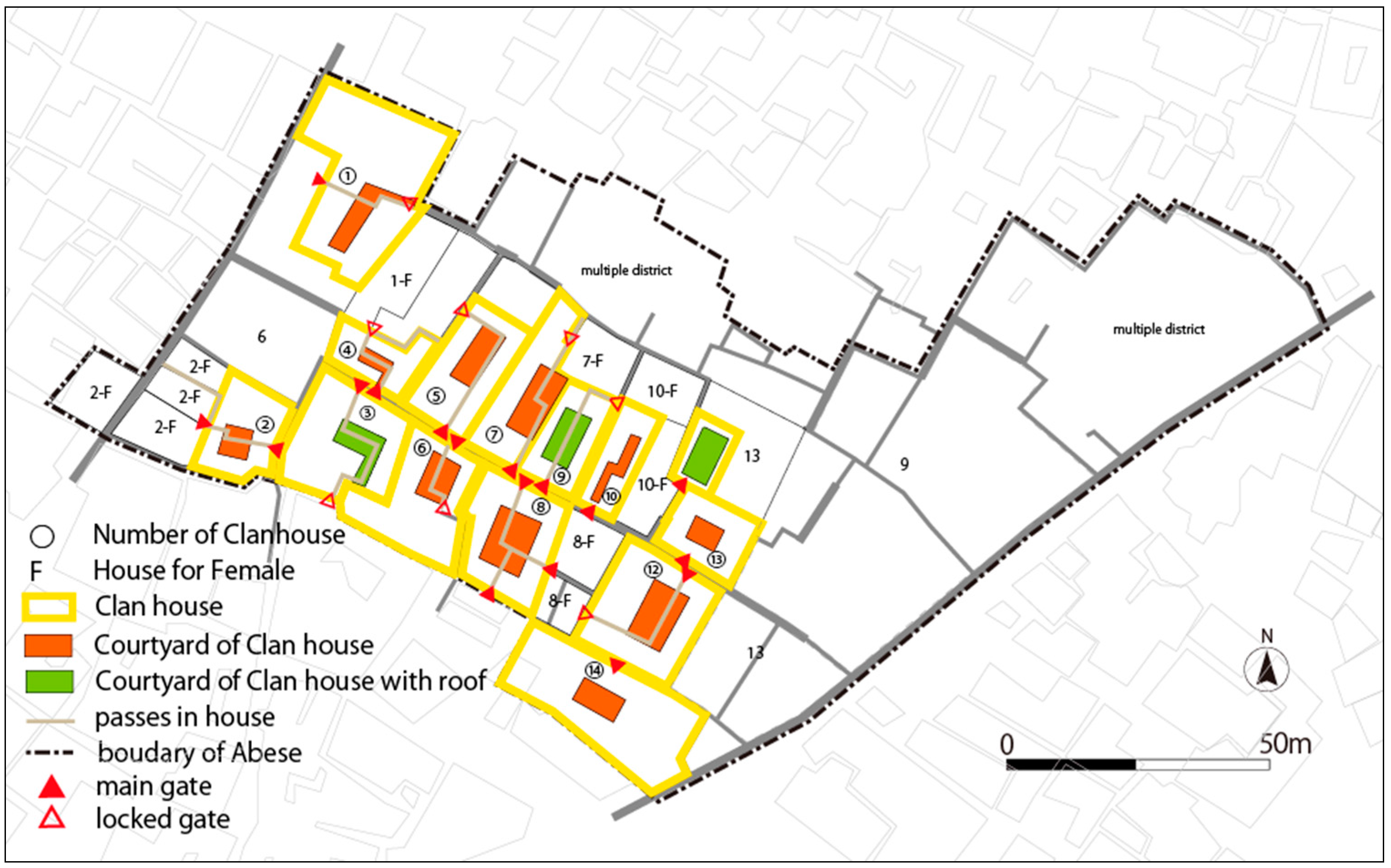
4.1.1. Structure and Social Functionality of Clan Houses

There are fifteen main clan houses within the Abese quarter, which are courtyard based with entrances directed toward the streets and alleys (Figure 3). Physically, the clan houses are separated by alleys which generally intersperse the quarter. There are also passageways within the courtyard that allow residents to directly connect other houses or open spaces. In times past, each of the clan houses had separate compounds for women, which was in line with “duo-local” Ga culture that separated male (hiiamli) and female compounds (yeiamli). Females lived with children in the female compound, and visited husbands in the male compound. Currently, only four out of the fifteen clan houses adhere to this gendered separation within the clan house.
The courtyard within the clan houses also serve as an important “social space”—fostering discursive interactions among residents in the quarter (Figure 4). Weekly family or community meetings and traditional events (e.g., baby naming ceremonies or traditional marriage) are usually organized in the courtyard.
Furthermore, the study revealed that courtyard spaces provide physical opportunities for residents to converge inside the house to interact with others, socialize, and deepen existing bonds. Inside the clan houses, the elderly—who are typically family heads and in charge of the house—take seats with neighbors and residents and interact in a socially active atmosphere on matters of family, community welfare, dispute resolution and house improvement.

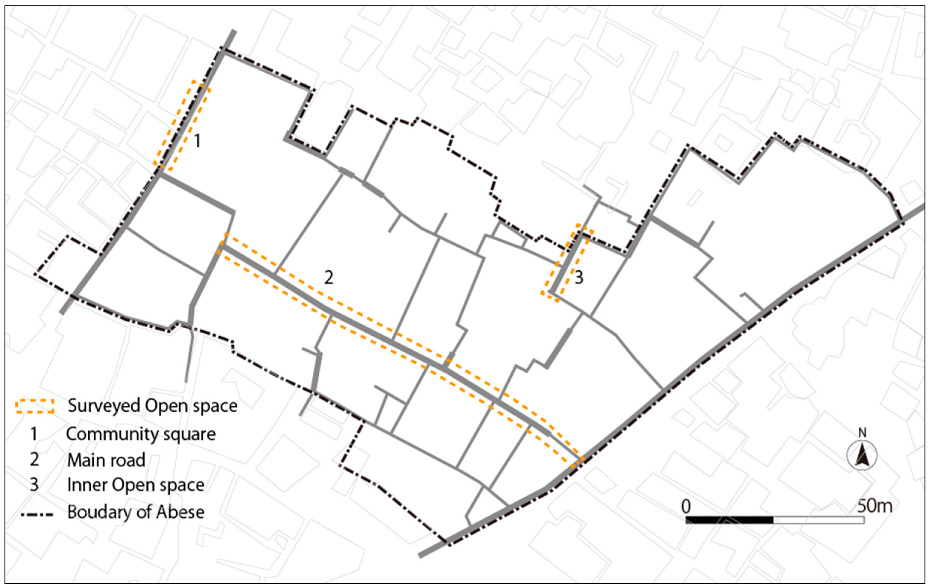
4.1.2. Distribution and Hierarchy of Roads

As part of our study in the Abese quarter, we sought to understand the distribution and hierarchy of roads as important elements in understanding how physical aspects shape social interactions and human behavior in the quarter.
Based on observation and spatial analysis of the quarter, we identified a 6-level hierarchy of roads (Figure 5). The quarter is enclosed within two arterial roads (Road 1), both of which link Abese with other quarters. Abese road (Road 2) divides the quarter, and the entirety of the traditional clan houses cluster around it. This area forms part of the original nucleus of the settlement. This road also links the two arterial roads (Road 1) to the north and south and serves as an important connector for the people of Abese to other quarters.
Generally, networks of roads or alleys are less than three meters wide (roads 4, 5 and 6). They disperse from the main road (Road 2) and connect to different parts of the quarter. There are also eleven passageways within the clan houses that make it possible for residents to connect between different houses through courtyards. Residents use these passageways to move freely between clan houses and connect with other residents. The study revealed that these enabled residents to freely move between houses to interact, seek assistance or check on their neighbors’ well-being frequently.
Additionally, before major local events such as festivals or community cleaning exercises, local announcers use these passageways to easily access the clan houses and inform residents about upcoming program schedules and residents’ roles. There are gates that lock eight of the eleven passageways. Here, the elderly in the clan house control access. The locked gates are to prevent uncontrolled access by those who do not live within the Abese quarter. However, all gates are opened during major community events like the “homowo” festival, traditional weddings, funerals or community clean-up exercises. The spatial distribution of the road and alleys has formed a “tributary system” or “network” where narrow alleys (under 3 m wide) connect wider roads (over 3 m wide).
The next section presents the observed social interactions and human behavior in open spaces as an element of the spatial dynamics in the Abese quarter with an emphasis on physical space and its multiple relevance to residents’ everyday life.

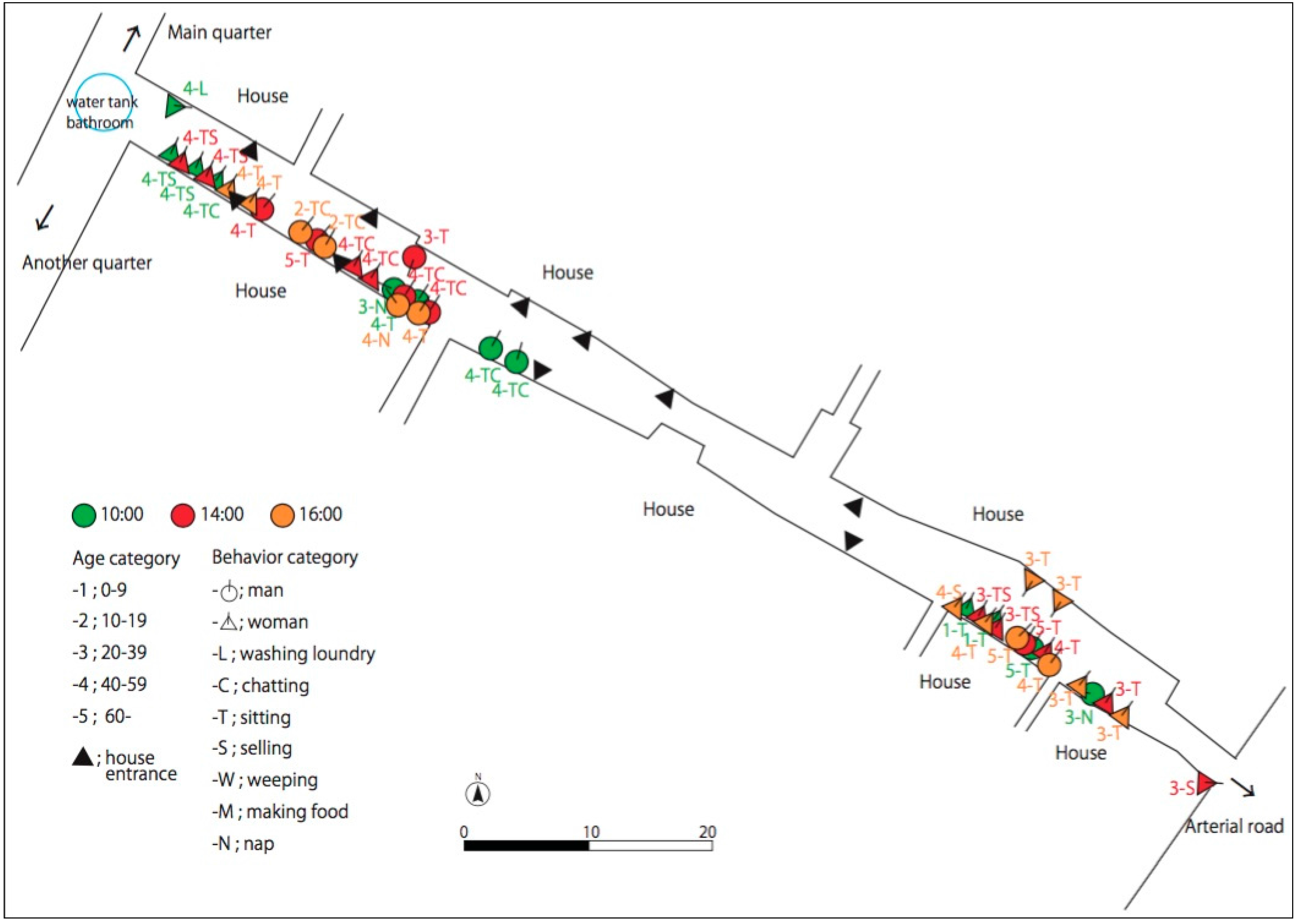
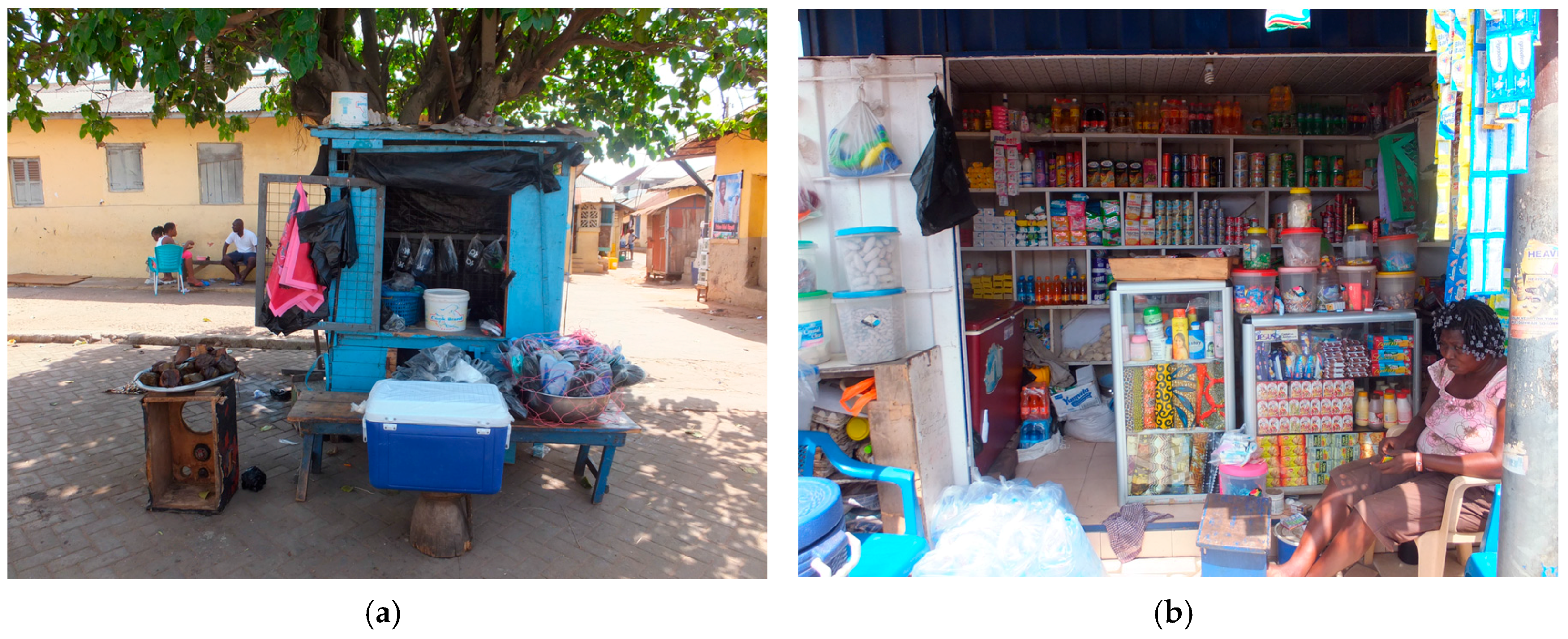
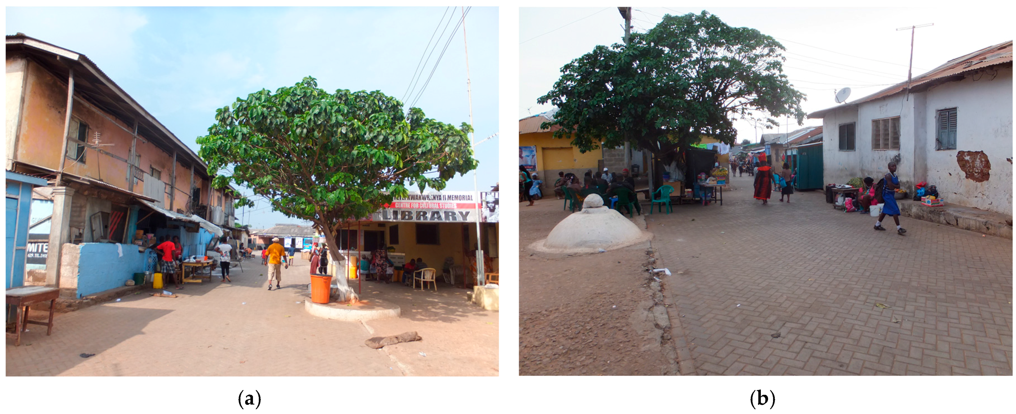
4.1.3. Social Interactions and Human Behavior in the Open Spaces in Abese

Human activities in open spaces are necessary to understand human needs, behavior and their interactions with the physical environment around them. Here, with “faculty of sight” [23,52] we employ unstructured direct observation to understand how people relate to physical space in Abese quarter. We argue that relevant open spaces are those open to public use, generating active and passive social and functional behavior and interactions and, thus, forming the rationale for the selection of open spaces. Following this argument, we selected three main open spaces: Abese road, the main public square, and an inner open space (Figure 6). We do not, however, claim that these are the only open spaces in the settlement. For this section, we categorized human behavior into social, economic and stationary activities (we built on the categorization offered by Metha [23]. Thus, “social” refers to observed interactions among two or more residents, “economic” refers to income-generating activities within open spaces, while “stationery activities” entail individual activities such as sleeping/napping, or non-interactive and non-economic-based activities. We are, however, aware of the overlaps and the simplification within such a categorization.).
(1) Abese Road (Main Road)
This road is an important open space within the quarter because the entrance of ten of the fifteen clan houses open directly onto it. Also, clan houses are concentrated along it (Figure 3). In the mornings, the main activities observed were economically oriented. These were home-based informal economic activities such as food-vending, or small-scale grocery shops run by women. Such economic activities were concentrated at the extreme ends of the road (Figure 7). The road network influences this concentration of activities. The entry/exit points of the Abese road connect to two main arterial roads that directly link to the local station, and thus experiences relatively high movement of people. Residents in the quarter, with knowledge of this physical configuration, strategically locate informal economic activities at locations such that they are able to access potential consumers. As these economic activities take place, an “economic node” and a “social node” are created, such as when other female residents join women vendors at their selling location, not necessarily to patronize businesses, but to chatter.
In the afternoon, apart from women engaging in economic activities such as food vending and grocery stores, men—within the working age cohort (20–59 years)—were observed sitting and chatting in the area.
Conversely, in the evening, we observed a shift in human behavior from economic to mostly social behavior. Male and female residents of varying age cohorts sit, chat and interact with one another in the quarter. The sociable and lively nature of this open space at night is made possible by the lighting of the street (though minimal) and adequate space to put benches for sitting. It is noteworthy, however, that social activities are located at the ends of the road. This is because the middle area is narrow (2.9 m, Figure 7), and does not afford enough space for residents to sit on the typical long benches to chatter and simultaneously allow passage for others who access the road at night.
(2) The Community Square
In addition to the main road, we studied the community square (Figure 8 and Figure 9) located in the northwestern part of the quarter. It directly links the arterial road that connects the quarter to the local station (transport terminal at the southwest section of the area) and one of the commercial areas in the municipality. It also serves as a passage to neighboring quarters such as Dzrase. In the eastern part, it connects the main road that divides the Abese quarter. A recently-constructed community library adjoins the square (Figure 10), with a tent erected in front of the library for outdoor educational activities for school children. There are also two big trees centrally located in the square.
In this open space, the main activities in the morning include preparing and selling food or groceries (economic) (Figure 9), napping (stationary) or chatting (social). As compared to other open spaces within the quarter, the square was wide enough (an area of about 249.6 m2) to provide women space to prepare and sell their food on site. This location is also suitable for economic activities because it directly links the arterial road that connects the area with a local station and other neighborhoods (Figure 8).
In the afternoon, stationary activities such as sleeping or napping were apparent. Typically, women selling here put their babies or young children to nap in the shaded area (tent area) in front of the library (Figure 10). What is noticeable in this open space is the cluster of activities around the big tree or in front of the library. This is because it provides shading and cover from the hot weather during the late morning and afternoon hours. Also, women were observed conversing with each other as they waited on customers to patronize their goods.
Evening activities were predominantly social in nature. Sitting and chatting among men and women were observed in this open space. People usually gathered in groups. Gathering in the open space is a very important part of life and a routine activity among residents in the quarter for strengthening social bonds.
(3) The Inner Open Space
This open space (Figure 11) is enclosed within three individual houses near the eastern boundary of the Abese quarter. The spaces between these three houses are also connected by three narrow alleys, which allow residents within surrounding houses to move freely between the houses and the open space. The peculiar location and physical enclosure of this space mean that its use has been different from the other open spaces mentioned above. In the morning, young men (20–39 years) were observed sitting and chatting while women washed laundry. Similar activities were recorded in the afternoon, even though the sitting positions shifted to the edge of the houses, under the extended roofs. This was to gain shading and protection from the hot weather. Comparably, evening activities typically involved sitting and chatting. This inner space is therefore mainly for social use, as residents from the three houses around the space gathered primarily to socialize or relax.
However, the comparatively-limited economic use of this inner space is apparently due to its enclosure between individual houses; a space which has been appropriated by inhabitants for domestic use, such as washing and socializing with friends and neighbors. Furthermore, without a direct link to the street and high passage of people, this space does not provide a good location for informal economic activities as compared to other open spaces discussed above.

5. Discussion

The results from the study provide credence to the relevance of the socio-spatial contexts that shape the everyday experience of urban informal settlements. By drawing specifically on the spatial organization of social interactions and human behavior in the Abese quarter, some critical findings are apparent.

5.1. “Social Logic of Space”

To start with, the physical structure and organization and social life [60] of the courtyards in the quarter show the dynamic nature of such spaces. They contribute to and sustain socio-cultural practices in the quarter. This supports the “social logic of space” notion [61]. In this case, through the courtyard, it is possible to observe how both social and cultural patterns are imprinted and function in spatial layouts as well as how they are changing [61]. For instance, the study revealed that “duo-local” Ga culture persisted, but changed and became “blurred” due to intermarriage with other cultures, increase in family size and the general trend of western and globalized lifestyles in cosmopolitan GAMA. This contributes to the changing residential practices in indigenous informal residential neighborhoods in GAMA [62]. Social gatherings and interactions in courtyards of the clan houses also emphasized that the various clan houses are not just physical layouts in the spatial organization of the quarter. Rather, with the family members and other residents within the house, they form a socio-spatial structure that underlines everyday life in the Abese quarter.
This observation, however, is not unique to this site. Previous studies have pointed to how most indigenous Ghanaian communities, in GAMA and elsewhere, are composed of family houses where cultural values and ethnic principles are embedded in built forms [17,22]. Nonetheless, this study presents a unique focus on clan-based spatial organization in informal-but-legal settlements in GAMA. The study reveals that, beyond how residents build houses within such settlements [22], the nature of accessibility and permeability through roads and alleys is configured to facilitate social interaction. It also stands in marked contrast to migrant and squatter settlements [62], where such socio-spatial and cultural imprints may be missing. Either way, this reinforces the idea that, in spite of on-going urban changes, (post-)colonial cities in Africa and elsewhere, are spatially delineated and culturally differentiated [21].

5.2. Gendered Spaces and Activities in the Abese Quarter

There were some gender roles in the use of spaces in the quarter. The first evidence was the “duo-local” Ga culture that separated men’s and women’s residences. The second evidence is the dominance of women in economic activities, which points to cultural norms where informal activities, such as food-vending, are considered “women’s occupations”. This finding confirms earlier observations that home-based economic activities, usually run by women, are common in low-income settlements in the GAMA and other African cities, adopted as an income-earning strategy to address poverty and unemployment [63].

5.3. An Urban Mixity in the Abese Quarter

The human behaviors observed in the three open spaces imply an element of “mixity”: that is, a mixed category of social, economic and stationary human behaviors between residents of different gender and age cohorts [53,54,55]. It also demonstrates what urban scholars have noted as flexibility [64] and adaptability of space [65], which reflects how spaces can accommodate different activities and offer residents the possibility to invent behaviors and activities that meet their needs [23]. Again, the social and economic use of open spaces in Abese reinforces the thinking that open spaces must be associated with social and economic functionality rather than just a channel for movement [23,60,66,67].

5.4. Permeability of Spaces in the Abese Quarter

The irregular network and hierarchy of roads and alleys in Abese quarter has created some form of permeability that reveals the importance of accessibility and connectivity in facilitating patterns of human behavior and social interactions. This has created an environment that enables residents to move around the quarter and utilize these connections for their benefit. We find that residents’ understanding of their setting, and how it engenders specific human behaviors, afforded some of them the opportunity to strategically undertake different activities within the quarter. Thus, the relevance of the network of roads and alleys are beyond movement or passage, as they also serve as important open spaces for sustaining daily urban life. This is contrary to the walled enclosures in other settlements in the district and therefore promotes social and spatial interaction between residents and physical elements. These observations align with the notion that the life of urban communities is in its roads (streets or alleys) and they contribute significantly to sustaining the public realm and lively community life [60,68,69].

5.5. Livelihoods in the Abese Quarter

Open spaces in the Abese quarter facilitate public use and generate active and passive functional human behavior and social interactions. They afford residents the opportunity to appropriate these informal spaces to support their everyday activities. Such appropriation facilitates inclusiveness [23,70] that enables residents to meet their needs, such as having access to food or to engage in some form of economic livelihoods. The economic use of open spaces is indicative of how residents in low-income communities in GAMA use rent-free spaces around houses in low-income neighborhoods for informal economic activities to generate income for addressing their socio-economic problems [71]. At the same time, the idleness of some residents in the open spaces provides hints of their level of involvement in the local economy. Men within the working age range of 20–59 years observed sitting and chatting during the active part of the day may be indicative of the high unemployment rate (10 percent), or the unstable informal job rate (85 percent) among residents of the quarter [10,11,12].

5.6. Evidence of the Five Critical Pillars of Public Space Design in the Abese Quarter

In addition, open spaces studied in the study area exhibit five critical pillars of public space design: meaningful activities, comfort, safety, pleasure, and inclusiveness [23]. Although residents have some comfort in having seating areas to play games, the hot climate effects cause them to seek protection from the sun in shaded areas. Other studies confirm this human behavior in open spaces, revealing that people usually congregate in areas where shading exists to seek protection from harsh natural elements [51,72,73]. It also indirectly hints at the need for greening and shading elements to improve the physiological suitability of open spaces in hot weather communities such as the Abese quarter. We thus see how climatic conditions create discomfort and cause changes in human behavior and the use of such open spaces [23,64,72]. We also find that the available spaces either facilitate or discourage specific activities.
Again, the location and physical configuration of informal open spaces exerted limitations on informal economic activities and social interactions in the inner open space and Abese road. Hence, the limitation on human behavior offered by the physical layout of these informal spaces suggest that “behavior settings” [71,72], such as physical convenience for sitting and gathering, may affect human behavior in open spaces. On the contrary, the nature of the courtyards in the various clan houses supported active social and cultural activities. This hints of a strong social bonding and kinship among residents in the quarter. The open spaces were lively and ensured security as there were always “eyes on the street” [60]. Also, the open spaces provided meaningful activities such as food vending and made the place pleasurable through the enduring conversations between residents in those informal spaces.
The Abese study also unveils an interesting awareness that lively open spaces emerge dynamically as part of the social interactions and human behavior in urban informal spaces. This revelation points to the importance of studying and analyzing human behavior as it provides a more appropriate lens to understand how active and lively open spaces in urban areas can be encouraged [23,60,69].

6. Implications and Conclusions

This paper has established that social interactions and human behavioral activities drive the spatial organization of the indigenous informal quarter of Abese. These spatial dynamics are critical to creating lively urban spaces as well as strengthening social bonds and relationships within this urban informal settlement. More importantly, the social interactions and human behavioral activities and its spatial aspects has created conditions that have enabled the Abese quarter to remain resilient to globalization and neoliberal urban processes. The quarter has thus retained its unique identity as a clan-based system that supports residents’ indigenous culture and socio-economic activities. These understandings, therefore, provide critical directions for promoting sustainable community-based planning and design interventions sensitive to existing local conditions, as well as the indigenous identity of the settlement.
Specifically, to promote sustainable community-based planning and design of informal settlements, urban planners need to pay attention to spatial structure and physical configuration. For instance, even though the Abese quarter has a permeable spatial pattern, the irregular and narrow width of alleys poses a potential challenge to disaster support in the unexpected case of fire or flooding. Spatial reconfiguration through design modifications is, therefore, necessary. This, however, should be informed by the indigenous open and permeable system of roads and alleys, which can potentially support physical connectivity and accessibility in the quarter.
Secondly, to address the issue of physical comfort in the use of informal spaces, there is a need for critical attention to landscaping and greening strategies. Urban greening has received little consideration in Ghanaian cities [74,75], and much less in informal settlements. Studies show that greening and landscaping in urban areas improve social liveliness, enhance aesthetics, and foster environmental behavior settings that support positive spatial and social experiences [70,76,77,78,79]. Particularly, such interventions are important for fostering micro-scale local sustainability practices in indigenous informal settlements. Climate supportive interventions such as green infrastructure can also be introduced in informal settlements to deepen social interactions and urban mixity patterns in informal open spaces. However, this requires in-depth collaboration with local and national stakeholders, community leaders, and residents of the Abese quarter. Specifically, working together with residents to integrate their knowledge of the spatial and social aspects, and behavior patterns into the quarter’s planning and design process, as was in the case of biomimicry in South Africa [80].
Thirdly, the urban mixity pattern points to the relevance of open spaces that afford diversity in terms of uses and users in informal settlements. The existing pattern that supports residents’ social, economic and functional use of informal spaces implies that future planning and design for indigenous informal settlements such as Abese quarter need to promote mixity patterns. Hence, open spaces should be designed in a manner which is adaptable and flexible to the everyday economic, social and functional needs of residents in informal settlements.
Moreover, even though the growth of urban informal settlements appears pervasive in Ghanaian and African cities generally, for urban professionals and researchers, this paper emphasizes the imperative to recognize the micro-scale differentiation in behaviors and practices (e.g., between indigenous and migrant areas). This could assist in the adoption of appropriate methodologies for neighborhood level studies that capture such differences and propose interventions that respond to their peculiarities for sustainable improvements.
In a broader perspective, future comparative studies in other migrant and indigenous settlements in the GAMA will be needed to provide further planning and policy directions. In the end, the spatial dynamics of social interactions and human behavior in informal settlements should not be treated in isolation but rather integrated into the evolving process of planning and design of urban informal settlements.

Acknowledgments

The authors are grateful to Nii Kwade Okropong I and people of the Abese Division of La Dadekotopon for their hospitality and cooperation during the data collection. We are particularly indebted to Eric Nii Anyetei for his invaluable service as a local informant and guide during the data collection.

Author Contributions

Seth Asare Okyere, Miyuki Hiraoka, Michihiro Kita and Stephen Kofi Diko conceived the research and developed the framework; Seth Asare Okyere, Miyuki Hiraoka and Michihiro Kita undertook the fieldwork. Michihiro Kita and Miyuki Hiraoka developed the maps, while Seth Asare Okyere and Stephen Kofi Diko analyzed the field data. All the authors wrote the paper.

Conflicts of Interest

The authors declare no conflict of interest.

References

  1. Songsore, J. The Urban Transition in Ghana: Urbanization, National Development and Poverty Reduction. Available online: http://pubs.iied.org/pdfs/G02540.pdf (accessed on 30 November 2016).
  2. Silver, J. Incremental Infrastructures: Material improvisation and social collaboration across post-colonial Accra. Urban Geogr. 2014, 35, 788–804. [Google Scholar] [CrossRef]
  3. Grant, R.; Yankson, P. City Profile: Accra. Cities 2003, 20, 65–74. [Google Scholar] [CrossRef]
  4. Pellow, D. The Power of Space in the Evolution of an Accra Zongo. Ethnohistory 1991, 38, 414–450. [Google Scholar] [CrossRef]
  5. Pellow, D. Migrant communities in Accra, Ghana: Marginalizing the margins. In Globalization and the Margins; Grant, R., Short, J., Eds.; Palgrave Macmillan: London, UK, 2002; pp. 111–129. [Google Scholar]
  6. Pellow, D. Landlords and Lodgers: Socio-Spatial Organization in an Accra Community; Praeger: Westport, CT, USA, 2002. [Google Scholar]
  7. UN Habitat. State of the World Cities Report, United Nations Human Settlement Program; UN Habitat: Nairobi, Kenya, 2016; Available online: http://wcr.unhabitat.org/main-report/ (accessed on 23 January 2016).
  8. UN Habitat/AMA. Participatory Slum Upgrading and Improvement Program; Accra Metropolitan Assembly: Accra, Ghana, 2011. [Google Scholar]
  9. Okyere, A.S.; Kita, M. Rethinking urban informality and informal settlement growth in urban Africa: A Literature discussion. J. Sustain. Dev. Afr. 2015, 17, 101–124. [Google Scholar]
  10. LaDMA. District Medium-Term Development Plan (2014–2017); La Dadekotopn Municipal Assembly: Accra, Ghana, 2014. [Google Scholar]
  11. Ghana Statistical Service (GSS). 2010 Population and Housing Census. District Analytical Report; LaDadeKotopon Municipal Assembly, Ghana Statistical Service: Accra, Ghana, 2014. [Google Scholar]
  12. Okyere, A.S.; Kita, M. ‘See this is a very good place, we are doing many things’: Residents activities and satisfaction in Abese-La. J. Sustain. Dev. Afr. 2016, 18, 77–100. [Google Scholar]
  13. Njoh, A.J. Modernist Urban Planning as a Tool of Acculturation: Implications for Sustainable Human Settlement Development in Cameroon. City Cult. Soc. 2013, 4, 111–120. [Google Scholar] [CrossRef]
  14. Boonstra, B.; Boelens, L. Self-Organization in Urban Development: Towards a New Perspective on Spatial Planning. Urban Res. Pract. 2011, 4, 99–122. [Google Scholar] [CrossRef]
  15. Owusu, G. Social effects of poor sanitation and waste management on poor urban communities: A neighborhood-specific study of Sabon Zongo, Accra. J. Urban. 2010, 3, 145–160. [Google Scholar] [CrossRef]
  16. Nunbogu, A.M.; Korah, I.P. Self-organization in urban spatial planning: evidence from the Greater Accra Metropolitan Area, Ghana. Available online: http://www.tandfonline.com/doi/full/10.1080/17535069.2016.1238502 (accessed on 5 January 2017).
  17. Konadu-Agyemang, K. A Survey of housing conditions and characteristics in Accra, an African city. Habitat Int. 2001, 25, 15–34. [Google Scholar] [CrossRef]
  18. Grant, R. Out of Place? Global Citizens in Local Places: A study of Informal settlements in Kore Lagoon Environs in Accra. Urban For. 2009, 17, 1–24. [Google Scholar]
  19. Grant, R. Globalizing City: The Urban and Economic Transformation of Accra, Ghana; Syracuse University Press: New York, NY, USA, 2009. [Google Scholar]
  20. Obeng-Odoom, F. The Informal Sector in Ghana under Siege. J. Dev. Soc. 2011, 27, 355–392. [Google Scholar] [CrossRef]
  21. Coquery-Vidrovitch, S. The Process of Urbanization in Africa (From the Origins to the Beginning of independence. Afr. Stud. Rev. 1991, 34, 1–98. [Google Scholar] [CrossRef]
  22. Pellow, D. Cultural Differences and Urban Spatial Forms: Elements of Boundedness in an Accra Community. Am. Anthropol. 2001, 103, 59–75. [Google Scholar] [CrossRef]
  23. Mehta, V. The Street: A Quintessential Social Public Space; Routledge: New York, NY, USA, 2013. [Google Scholar]
  24. Lang, J. Creating Architectural Theory: The Role of the Behavioral Sciences in Environmental Design; Van Nostrand Reinhold Co.: New York, NY, USA, 1987. [Google Scholar]
  25. Gibson, J.J. An Ecological Approach to Visual Perception; Houghton Mifflin: Boston, MA, USA, 1979. [Google Scholar]
  26. Canter, D. Understanding, assessing, and acting in places: Is an integrative framework possible? In Environment, Cognition, and Action: An Integrative Approach; Evans, G., Ed.; Oxford University Press: New York, NY, USA, 1991. [Google Scholar]
  27. Oktay, D. Urban Spatial Patterns and Local Identity: Evaluation in a Cypriot Town. Open House Int. 1998, 23, 17–23. [Google Scholar]
  28. Okazaki, R.; Miyake, R. A study on the Living Environment of Harar Jugol, Ethiopia. J. Archit. Plan. Res. 2012, 77, 951–957. [Google Scholar] [CrossRef]
  29. Lewis, W.A. Economic Development with Unlimited Supplies of Labor. Manch. Sch. 1954, 22, 139–191. [Google Scholar] [CrossRef]
  30. Hart, K. Informal Income Opportunities and Urban Employment in Ghana. Mod. Afr. Stud. 1973, 11, 61–89. [Google Scholar] [CrossRef]
  31. AlSayyad, N. Urbanism as a “new” way of life. In Urban Informality: Transnational Perspectives from the Middle East, South Asia and Latin America; Roy, A., AlSayyad, N., Eds.; Lexington Books: Lanham, MD, USA, 2004; pp. 7–30. [Google Scholar]
  32. De Soto, H. The Mystery of Capital, Why Capitalism Triumphs in the West and Fails Everywhere Else; BlackSwan Books: London, UK, 2000. [Google Scholar]
  33. Ojong, N. Livelihood Strategies in African Cities: The Case of Residents in Bamenda, Cameroon. Afr. Rev. Econ. Fin. 2011, 3, 8–24. [Google Scholar]
  34. Friedmann, J. Globalization and the emerging culture of planning. Prog. Plan. 2005, 64, 183–234. [Google Scholar] [CrossRef]
  35. Castells, M. The City and the Grassroots: A Cross-Cultural Theory of Urban Social Movements; University of California Press: Berkeley, CA, USA, 1983. [Google Scholar]
  36. Roy, A. Transnational trespassing: The geopolitics of urban informality. In Urban Informality: Transnational Perspectives from the Middle East, South Asia and Latin America; Roy, A., AlSayyad, N., Eds.; Lexington Books: Lanham, MD, USA, 2004; pp. 289–317. [Google Scholar]
  37. Roy, A. Urban Informality: Towards a new epistemology of Planning. J. Am. Plan. Assoc. 2005, 71, 147–158. [Google Scholar] [CrossRef]
  38. Gilbert, A. On the mystery of capital and the myths of Hernando de Soto—What difference does legal title make? Int. Dev. Plan. Rev. 2002, 24, 1–19. [Google Scholar] [CrossRef]
  39. Roy, A. Why India cannot plan its Cities: Informality, Insurgence and the Idiom of Urbanization. Plan. Theory 2009, 8, 76–87. [Google Scholar] [CrossRef]
  40. Lombard, M. Constructing ordinary places: Place making in urban informal settlements in Mexico. Prog. Plan. 2014, 94, 1–53. [Google Scholar] [CrossRef]
  41. UN Habitat. State of the African Cities Report: Re-Imagining Sustainable Urban Transition; United Nations Human Settlements Programme: Nairobi, Kenya, 2014. [Google Scholar]
  42. Roy, A. Slumdog cities: Rethinking subaltern urbanism. Int. J. Urban Reg. Res. 2011, 35, 223–238. [Google Scholar] [CrossRef] [PubMed]
  43. Myers, G. African Cities: Alternative Visions of Theory and Practice; Zed book: New York, NY, USA, 2009. [Google Scholar]
  44. Huchzermeyer, M. Unlawful Occupation: Informal Settlements and Urban Policy in South Africa and Brazil; Africa World Press: Trenton, NJ, USA, 2004. [Google Scholar]
  45. Guilespie, T. Accumulation by urban dispossession: Struggles over urban space in Accra, Ghana. Trans. Inst. Br. Geogr. 2016, 41, 66–77. [Google Scholar] [CrossRef]
  46. Huchzermeyer, M. Settlement Informality: The Importance of Understanding Change, formality and land and the informal economy. Presented at the Groupement de Recherche sur Development International (GRDI) Workshop on Informality, Centre for Urban and Built Environment Studies (CUBES), University of the Witwatersrand, Witwatersrand, South Africa, 3–4 July 2008. [Google Scholar]
  47. Huchzermeyer, M. Elimination of the Poor in Kwazulu-Natal. Available online: https://www.pambazuka.org/governance/elimination-poor-kwazulu-natal (accessed on 5 January 2016).
  48. Barker, R. Ecological Psychology; Stanford University Press: Stanford, CA, USA, 1968. [Google Scholar]
  49. Perin, C. With Man in Mind; MIT Press: Cambridge, MA, USA, 1970. [Google Scholar]
  50. Mehta, V.; Bosson, J. Third Places and the Social Life of Streets. Environ. Behav. 2010, 42, 779–805. [Google Scholar] [CrossRef]
  51. Rapoport, A. History and Precedent in Environmental Design; Plenum Press: New York, NY, USA, 1990. [Google Scholar]
  52. Cullen, G. Townscape; Architectural Press: Oxon, MD, USA; New York, NY, USA, 1961. [Google Scholar]
  53. Baumeister, J.; Knebel, N. The Indigenous Urban Tissue of Addis Ababa—A City Model for the Future Growth of African Metropolis. In Proceedings of the Conference on African Perspectives—The African city (re)sourced, Pretoria, South Africa, 25–28 September 2009. [Google Scholar]
  54. Clerc, V. Mixity in Urban Policies directed towards Informal Settlement Areas in Damascus, a Concept for Public Decision? In Proceedings of the 23rd ENHR Conference (European Network on Housing Research), Toulouse, France, 5–8 July 2011; Available online: https://www.researchgate.net/publication/281326537 (accessed on 11 March 2017).
  55. Wankiewicz, H. City Region of Short Distance for All? Planning the ‘Everyday’ for a Diversity and Mixity of Users in Functional Areas. In Proceedings of the REAL CORP, Schwechat, Austria, 14–16 May 2012. [Google Scholar]
  56. Merrifield, A. Dialectical Urbanism; Monthly Review Press: New York, NY, USA, 2002. [Google Scholar]
  57. Abekar Mensah, J. Traditions and customs of the Ga-Adamgbe of Ghana; Strategic Book Publishing and Rights Co.: Houston, TX, USA, 2013. [Google Scholar]
  58. Owusu, G. Decentralized Development Planning and Fragmentation of Metropolitan Regions: The Case of the Greater Accra Metro-politan Area, Ghana. Ghana J. Geogr. 2015, 7, 1–24. [Google Scholar]
  59. Amoako, C. Brutal presence or convenient absence: The role of the state in the politics of flooding in informal Accra, Ghana. Geoforum 2016, 77, 5–16. [Google Scholar] [CrossRef]
  60. Mehta, V. Lively Streets: Determining Environmental Characteristics to Support Social Behavior. J. Plan. Educ. Res. 2007, 27, 165–187. [Google Scholar] [CrossRef]
  61. Hillier, B.; Vaughan, L. The city as one thing. Prog. Plan. 2007, 67, 205–230. [Google Scholar]
  62. Appeaning-Addo, I. Perceptions and Acceptability of Multi-habitation as an Urban Low Income Housing Strategy in Greater Accra Metropolitan Area, Ghana. In Urban Forum; Springer: Berlin, Germany, 2013; pp. 543–571. [Google Scholar]
  63. Gough, K.V.; Tipple, G.; Napier, M. Making a Living in African Cities: The Role of Home-based Enterprises in Accra and Pretoria. Int. Plan. Stud. 2003, 8, 253–277. [Google Scholar] [CrossRef]
  64. Loukaitou-Sideris, A.; Ehrenfeucth, R. Sidewalks: Conflict and Negotiation over Public Space; MIT Press: Cambridge, MA, USA, 2009. [Google Scholar]
  65. Frank, K.; Stevens, Q. (Eds.) Loose Space: Possibility and Diversity in Urban Life; Routledge: New York, NY, USA, 2007. [Google Scholar]
  66. Jacobs, A. Great Streets; MIT Press: Cambridge, MA, USA, 1993. [Google Scholar]
  67. Gehl, J. Life between Buildings; Van Nostrand Reinhold: New York, NY, USA, 1987. [Google Scholar]
  68. Thomas, M. The Demise of Public Space. In Town Planning Responses to City Change; Nadin, V., Doak, J., Eds.; Avebury: Aldershot, UK, 1991; pp. 209–224. [Google Scholar]
  69. Jacobs, J. The Death and Life of Great American Cities; Vintage Books: New York, NY, USA, 1961. [Google Scholar]
  70. Richardson, E.A.; Pearce, J.; Mitchell, R.; Kingham, S. Role of physical activity in the relationship between urban green space and health. Public Health 2013, 127, 318–324. [Google Scholar] [CrossRef] [PubMed]
  71. Yankson, P. Houses and Urban Neighborhoods as work places in urban areas: A study of selected low-income areas in the greater Accra metropolitan area. Singap. J. Trop. Geogr. 2000, 21, 200–214. [Google Scholar] [CrossRef]
  72. Zacharias, J.; Stathopoulos, T.; Wu, H. Microclimate and downtown open space activity. Environ. Behav. 2001, 33, 296–315. [Google Scholar] [CrossRef]
  73. Sullivan, W.; Kuo, F.; DePooter, S. The fruit of urban nature: Vital neighborhood spaces. Environ. Behav. 2004, 36, 678–700. [Google Scholar] [CrossRef]
  74. Mensah, C.A. Destruction of urban green spaces: A problem beyond urbanization in Kumasi city (Ghana). Am. J. Environ. Prot. 2014, 3, 1–9. [Google Scholar] [CrossRef]
  75. Arku, G.; Yeboah, E.A.I.; Nyantakyi-Frimpong, H. Public parks as an element of urban planning: A missing piece in Accra’s growth and development. Local Environ. 2016. [Google Scholar] [CrossRef]
  76. Nowak, D.J.; Crane, D.E. Carbon storage and sequestration by urban trees in the USA. Environ. Pollut. 2002, 116, 381–389. [Google Scholar] [CrossRef]
  77. Escobedo, F.; Nowak, D.J. Spatial heterogeneity and air pollution removal by an urban forest. Landsc. Urban Plan. 2009, 90, 102–110. [Google Scholar] [CrossRef]
  78. Maas, J.; Spreeuwenberg, P.; van Winsum-Westra, M.; Verheij, R.A.; de Vries, S.; Groenewegen, P.P. Is green space in the living environment associated with people’s feelings of social safety? Environ. Plan. A 2009, 41, 1763–1777. [Google Scholar] [CrossRef]
  79. Wolch, J.R.; Byrne, J.; Newell, J.P. Urban green space, public health, and environmental justice: The challenge of making cities ‘just green enough’. Landsc. Urban Plan. 2014, 125, 234–244. [Google Scholar] [CrossRef]
  80. Hermanus, L.; Campbell, A. Biomimicry builds urban possibilities in South Africa. Re.think. 16 March 2017. Available online: https://rethink.earth/biomimicry-builds-urban-possibilities-in-south-africa/ (accessed on 20 March 2017).
Figure 1. La Dadekotopon in regional context [11].
Urbansci 01 00013 g001
Figure 2. Map of the study area (Abese quarter).
Urbansci 01 00013 g002
Figure 3. Map showing clan houses and the physical relation with courtyard and network of alleys.
Urbansci 01 00013 g003
Figure 4. Courtyard within clan house being used for clan meeting.
Urbansci 01 00013 g004
Figure 5. Distribution and hierarchy of roads in Abese quarter.
Urbansci 01 00013 g005
Figure 6. Selected open spaces for studying human behavior.
Urbansci 01 00013 g006
Figure 7. Map of observed human behavior on main road within the quarter.
Urbansci 01 00013 g007
Figure 8. Human behavior in community square.
Urbansci 01 00013 g008
Figure 9. Economic activities organized within open spaces. (a) Small shop selling both home-cooked foods and groceries, (b) medium-sized grocery store in an open space.
Urbansci 01 00013 g009
Figure 10. Sections of the community square. (a) North side and (b) South side.
Urbansci 01 00013 g010
Figure 11. Map of human behavior in inner open space.
Urbansci 01 00013 g011

