

Mapping and Assessment of Housing Informality Using Object-Based Image Analysis: A Review

1
South African National Space Agency, Mark Shuttleworth Street, Innovation Hub, Pretoria 0087, South Africa
2
School of Geography, Archaeology and Environmental Studies, Faculty of Science, Witwatersrand University, Johannesburg 2050, South Africa
*
Author to whom correspondence should be addressed.
Urban Sci. 2023, 7(3), 98; https://doi.org/10.3390/urbansci7030098
Submission received: 8 April 2023
/
Revised: 22 June 2023
/
Accepted: 28 June 2023
/
Published: 21 September 2023
Abstract
:Research on the detection of informal settlements has increased in the past three decades owing to the availability of high- to very-high-spatial-resolution satellite imagery. The achievement of development goals, such as the Sustainable Development Goals, requires access to up-to-date information on informal settlements. This review provides an overview of studies that used object-based image analysis (OBIA) techniques to detect informal settlements using remotely sensed data. This paper focuses on three main aspects: image processing steps followed when detecting informal settlements using OBIA; informal settlement indicators and image-based proxies used to detect informal settlements; and a review of studies that extracted and analyzed informal settlement land use objects. The success of OBIA in detecting informal settlements depends on the understanding and selection of informal settlement indicators and image-based proxies used during image classification. To meet the local ontology of informal settlements, the transfer of OBIA mapping techniques requires the fine-tuning of the rulesets. Machine learning OBIA techniques using image proxies derived from multiple sensors increase the opportunities for detecting informal settlements on the city or national level.
1. Introduction
The world is experiencing alarming urbanization growth. In 1900, only 15% of the world’s population lived in urban areas [1]. This picture changed drastically during the 20th century. During the sixty years from 1950 to 2010, the world experienced rapid urbanization, leading to more than 50% of the world’s population living in urban areas [2]. Eight years later, more than 58% of the world’s population were living in urban areas [3]. The current projections indicate that approximately 75% of the world’s population will live in urban areas by 2050 [3], with most urban development expected to occur in the towns and cities of developing countries [4]. Unfortunately, urbanization in these countries is not always linked to economic development [5], and population influx often surpasses the formal housing supply. This is already evident from the development of informal settlements or slums and informal dwelling structures, including backyard shacks around the cities and towns of developing countries. Many countries and international bodies have initiated policies and strategies that set targets to provide adequate housing and improve the living conditions of people living in informal dwellings.
Informal settlements are illegal and lack access to improved water sources, sanitation facilities, good living areas, housing durability or security of tenure [6] and are usually homes for new migrants and unemployed or unskilled people [7]. In addition to the increased health, social and environmental vulnerability of people living in informal structures, the development of such dwellings can lead to environmental degradation. Even though the development of other forms of informal housing takes place on surveyed traditional land, the development of such structures is illegal, and the people living in such dwelling structures may lack security of tenure and direct access to basic services, leading to settlement informality. Effective urban planning requires access to consistent, reliable and up-to-date information on informal settlements and settlement informality.
In many countries, data on informal settlements are traditionally collected during ground surveys, including censuses. Censuses are usually conducted every ten years owing to the substantial financial resources required to conduct these surveys [8]. In addition, such censuses primarily capture headcount information rather than the spatial dimensions of informal settlements [8]. Even though the population census is the most comprehensive source of demographic data, information on informal settlements is usually underestimated compared to other settlement geographies [9]. The temporal gap of census data poses many challenges in planning services, as the fiscal transfer of services is based on headcounts. In addition, development agendas such as the Sustainable Development Goals (SDGs) use headcounts to assess progress toward the achievement of sustainable cities.
Understanding the spatial-temporal dynamics of informality in terms of demographic information, areal extent, morphology and environmental conditions can assist in the development of sustainable solutions to better manage urbanization. This paper reviews the published research on object-based image analysis (OBIA) methods for detecting informal settlements using remote sensing data, focusing on the indicators used to detect informal settlements. The paper also reviews the published research on the extraction of informal settlement land use features. The paper concludes by providing a summary and recommendations for potential future studies applying remote sensing in informal settlement mapping.
2. Origins and Characteristics of Informal Housing
Informal settlements existed in the 16th century in Europe, Australia and North America, serving to provide housing solutions in now-developed countries for those with little or no income [6]. Rapid urbanization during the Industrial Revolution led to the rapid increase in the number of slums during the last two decades of the 19th century [6]. These settlements were usually located within the cities in old buildings. They lacked access to essential services and were not included in the planning of the cities, leading to these areas having poor living standards and being sources of social ills such as crime and drug abuse [6].
Sub-Saharan African and South American urban areas were limited in number and extent during the pre-colonial era [6]. Examples include Jenne-Jeno in Mali and Aksum in Ethiopia. The urban settlements and towns were not formally planned but rather had settlements patterns, structures and land use systems dictated by their traditional and religious leaders. The dwelling structures in informal settlements differed from country to country and sometimes varied per ethnic group. Nevertheless, there was recognition of what constituted an acceptable settlement pattern, specifically one that provided for all necessary land uses, such as transportation, education and shops [10]. During the last few decades of the 19th century and early 20th century in sub-Saharan Africa, the European colonizers established and settled in new settlements and generally changed or expanded the existing urban areas so as to be situated closer to natural resources, leading to more people moving from rural areas to urban areas in search of employment with the established industries [10].
The colonizers also established coastal cities such as Cape Town, Lagos and Accra to facilitate the transportation and trading of resources [10]. The spatial plans of colonial cities were created using racial segregation policies resulting in underserviced or unserviced black areas, mostly informal settlements, located far from the commercial and desirable residential areas separated with buffers such as railway lines [11]. To this day, most informal settlements in developing countries are home to unskilled or semi-skilled workers who have become the labor pool for industries particularly affected by economic instabilities. Hence, most of these workers are laid off during recessions, making it difficult for them to change or improve their living conditions [12].
Nowadays, informal housing can be found in informal settlements where free-standing informal structures are built on illegal land [6]. The second scenario of informality in countries like South Africa takes place through the building of informal structures on formal surveyed land [13]. The third scenario is where people live in old buildings that lack city services. These settlements are mostly found within cities, such as the urban villages in some cities in China that were rural villages but are now rented out to create income (since agricultural land has been consumed by urbanization) [14]. The mapping of informal settlements or informal housing using remote sensing data requires a context-/country-specific understanding and definition of informality.
The terms informal settlement and slum are currently used interchangeably in United Nations documents [4]. Other terms are used to describe informal settlements in different countries, including fevals (Brazil), bidovilles (Francophone), villa miseria (Argentina) and kampungs (Indonesia and Malaysia) [6].
3. Mapping and Monitoring Informal Settlements Using Remote Sensing Technologies
Remote sensing technologies provide the capabilities to map and monitor informal settlement developments. The analysis of publications performed using the Scopus database in May 2023 shows that the number of studies using satellite imagery to map and monitor informal settlements or slums has increased since 2015, with fewer studies recorded between 1996 and 2008. Approximately 50% of the publications were published between 2019 and 2022, with the highest number of publications in 2019 (see Figure 1).
The increased interest in the studies on informal settlements in 2015 may be related to increased interest in informal settlements during and after the establishment of the SDGs. Even though informal settlements are mainly prevalent in Africa and Asia (where 80% of people live in informal settlements), most studies on formal settlements or slums have been conducted in Europe and the United States (see Figure 2).
South Africa is the only country in Africa that is among the top ten countries conducting research on informal settlements. Other African countries whose research has been published in the Scopus database include Kenya, Ghana, Zambia and Nigeria. India and China are the only countries researching informal settlements in Asia.
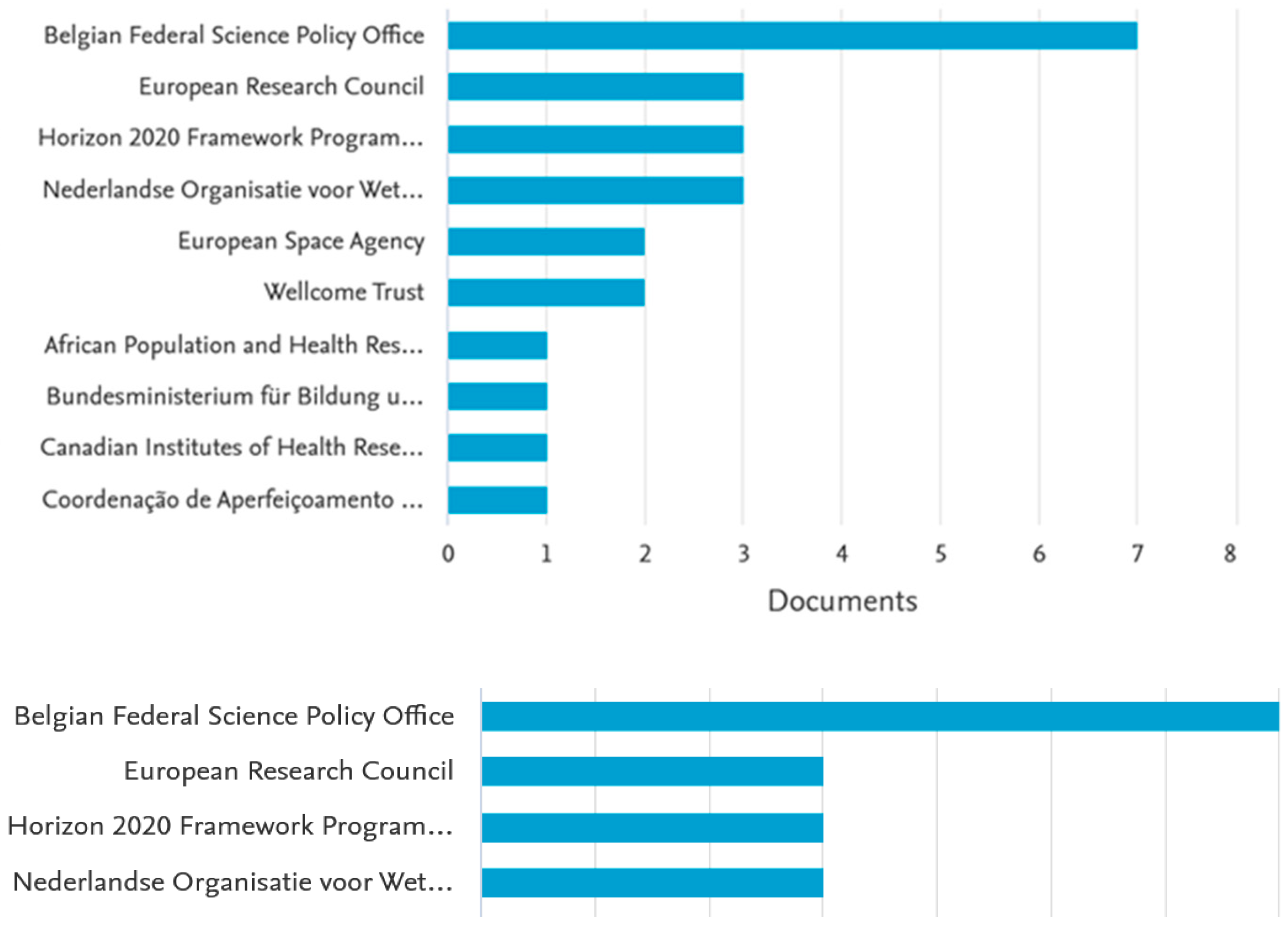
The proportion of studies in the different regions may be influenced by the funding opportunities to support research on informal settlements. Europe is the leading funder of research on informal settlement mapping (see Figure 3).
In addition, most of the published research on informal settlements is conducted by European academic institutions, as compared to research institutions or governments.
The methodologies used to detect informal settlements include manual digitization, pixel-based classification, OBIA, machine learning, and texture-based and statistical-based techniques. Even though visual image interpretation is time-consuming and resource intensive, it is still used today, as it produces more accurate results when performed by people with skills and experience in image interpretation [15].
The complexity of the roof materials of structures and the heterogeneity of land use in urban areas make it challenging to distinguish informal settlements from other land use types using spectral information based on high-spatial-resolution imagery alone [16]. The use of machine learning techniques for informal settlement mapping has been slowly increasing in recent years. Machine learning techniques have proven to perform better than survey-based mapping methods. These techniques depend on the settlements’ spectral, morphological or structural properties [17]. This leads to confusion between informal settlements versus formal settlements with small buildings [18]. The methodologies that have been tested in the detection of informal settlements include Random Forest (RF), Support Vector Machines (SVM) and Linear Regression. The SVM provides more accurate results with fewer errors of commission and omission [18,19]. Deep learning techniques such as Convolutional Neural Network (CNN) can potentially improve the accuracy of informal settlement classification [19,20]. Unlike pixel-based machine learning techniques, deep learning techniques use image patches during model training [20].
Additionally, known as Geographic Object-Based Image Analysis (GEOBIA), OBIA techniques have received increased attention in the past two decades as solutions for informa4l settlement detection [21,22]. Unlike pixel-based classification techniques, OBIA classification techniques use the spectral, spatial and contextual characteristics of image objects for classification [23].
Table 1 summarizes the differences between the mapping methodologies used to detect informal settlements.
The OBIA technique has been the most common method for informal settlement detection in the past two decades, as compared to other image-processing methods [15]. Compared to pixel-based classification, OBIA is beneficial for the classification of slums because the segmentation process generates segments that have additional spectral, geometric and textural information that is essential for differentiating slums [26,27]. The image segments contain descriptive statistics such as mean, median, minimum and maximum values per band and the mean ratios and variances of the images’ spectral, spatial and textural characteristics [26,27,28,29,30]. Multiresolution segmentation has been implemented successfully in GEOBIA to delineate buildings and uses scale, shape and compactness to segment objects [30].
The use of machine learning techniques and OBIA techniques to detect informal settlements is attracting interest from researchers. The settlement-based indicators and RF classifier successfully detected informal settlements with increased accuracy [31]. The use of the OBIA technique and RF classifier in the detection of informal settlements applying optical sensors and Synthetic Aperture Radar (SAR) images has the potential to produce more accurate results [32]. The OBIA technique (which uses settlement-level image features derived from high-spatial-resolution imagery) and RF (derived from high-spatial-resolution satellite imagery) have been used to detect informal settlement growth from Landsat temporal images with high accuracy [33].
3.1. OBIA Processing Steps
The first step in OBIA is image segmentation. This process partitions the image into meaningful objects used in classification or interpretation. OBIA was introduced around 2000 and implemented using software like Trimble eCognition. The multiresolution segmentation process is the most common image segmentation technique used in informal settlement detection [15]. One of the time-consuming tasks in image segmentation is the determination of the scale parameters that will produce image objects that represent the desired classes [24]. The scale parameter is an essential variable in image segmentation, as it determines the heterogeneity and size of the segmented objects [28]. The higher the scale parameter is, the higher the degree of heterogeneity of the object will be, resulting in larger image objects. Most studies have used a trial-and-error process to determine the scale parameter that would provide the required objects [21,26,34,35]. This supervised segmentation method requires the user to inspect the segmentation results using reference data or local knowledge. The parameters are then fine-tuned until the desired image objects are achieved.
The scale parameter remains a notable problem in the transferability of OBIA classification techniques. The transfer of image segmentation parameters from one sensor to another requires the parameters to be fine-tuned [27]. Reference data such as road or rail data have been used during the segmentation process to improve the boundaries of the resulting image object [35]. Some researchers have employed the Estimation of the Scale Parameter [30] to determine the scale parameter in order to segment informal settlement objects [32,36]. Several studies have used two segmentation levels to detect informal settlements [21,34,35]. This usually involves the segmentation of larger image objects to represent non-built-up versus built-up areas. In contrast, the second level uses higher scale values to create informal and formal land use objects used as sub-objects to distinguish informal settlements from formal settlements. The use of one segmentation level is observed when spectral-based features alone are used for the classification of informal settlements [35].
The availability of image-processing platforms such as Google Earth Engine provides opportunities to implement other segmentation methods, such as Simple Non-Iterative Clustering, which has been successful in segmenting informal settlement image objects from medium-spatial-resolution optical images and SAR [37]. Grid-based segmentation approaches are also used to create images in informal settlement detection [38,39].
Image classification in OBIA is usually performed using rulesets. Expert knowledge is required to generate these rulesets. The most challenging task during the mapping of informal settlements using OBIA is the translation of the characteristics of informal settlements into robust indicators that can be used across the globe during classification [31,40]. A Generic Slum Ontology (GSO) was developed to define generic indicators of informal settlements that can be used globally to detect informal settlements using remotely sensed data [40]. The GSO is based on the built morphology of informal settlements on three spatial levels, i.e., environment, settlement and object. The following subsections evaluate informal settlement indicators and OBIA techniques on these three spatial levels.
3.2. Detection of Informal Settlements Using Object-Level Indicators
Several studies have investigated using OBIA techniques to detect informal settlements [15,21,22,27]. The rulesets used for detecting informal settlements vary in terms of complexity from one area to another, depending on the ontology of the informal settlements. The object-level indicators tested or used to detect informal settlements include the tone and shape characteristics of dwelling structures [21,36]. The shape characteristics that are used serve to detect informal settlements’ size and the simplicity of their roof structures. The dwelling structures in informal settlements are usually smaller [31,36,41] and more irregular in shape [36] than formal structures.
The roofs of dwelling structures in informal settlements can be constructed from a wide range of materials, such as iron, plastic sheets, wooden boards or asbestos [36] and a combination of clothes, wood and straw [42,43]. Image features have been investigated to distinguish the tone and brightness of dwelling structures in formal settlements. Tone measures the intensity of the bands of the image. The use of measurements for the tone of the roofs of dwelling structures in informal settlements using high-spatial-resolution imagery alone is insufficient in detecting informal settlements [24]. This is due to spectral confusion between the dwelling roofs and the surrounding surfaces [24]. The studies investigating the use of shape characteristics of dwelling structures have achieved poor accuracies of around 2–65% [21,31,36].
3.3. Detection of Informal Settlement Using Settlement-Level Indicators
Settlement-level indicators are physical characteristics of informal settlements that describe the overall shape, form or density of the respective settlement [40]. These indicators include the relative density of building structures and the absence of regular road networks and vegetation. Further indicators are the lacunarity and orientation of built structures [40]. The density of structures in unformal settlements can vary from one settlement to another. In addition, the density of the structures can vary depending on the developmental stage of the informal settlement, i.e., in infancy, consolidation or maturity [43]. Several studies in the literature have been conducted on medium- to high-density informal settlements [21,22,27,35]. At the time of the writing of this paper, no studies had yet been published that focused on the use of remote sensing to detect informal settlements with low-density building structures. The image proxies used in the detection of informal settlements using settlement indicators include the grey-level co-occurrence matrix (GLCM), lacunarity of building structures to open spaces, and built-up and vegetation indices.
The measurement of the GLCM is used to analyze the occurrence of pairs of pixels with specific values and a specific spatial relationship [44]. The GLCM textural measurements are the image features commonly explored, investigated or used for informal settlement detection in areas with medium- to high-density building structures, from high- to very-high-spatial-resolution imagery [26,34,35,39,45]. The window size used during the texture analysis and the spatial relationship analysis can affect the detection of informal settlements [26,34]. The success of these GLCM features in detecting settlements varies from one area to another depending on the morphology of the settlement, the surrounding land use features and the developmental stage of the settlements [34,35]. The integration of GLCM and other features, such as vegetation indices, has been proven to increase the quality of the results [26].
Several studies have attempted to detect informal settlements by analyzing the presence or morphology of land use features. A lack of vegetation is one of the characteristics of informal settlements that have been investigated [15]. This indicator is assessed using vegetation indices such as the Normalized Differential Vegetation Index (NDVI). The NDVI quantifies vegetation cover and has been used to classify land use and land cover features [46]. Informal settlements typically have lower vegetation cover than formal settlements [21,26,35,47]. This indicator is mainly used with other indicators, such as high building density, to detect informal settlements. Even though lack of vegetation could be used as an indicator during informal settlement detection, studies that assess vegetation cover and the biophysical characteristics of informal settlements have not been conducted. Understanding the biophysical characteristics and environmental conditions could help to manage the development of a measure aiming to improve the resilience and health of people living in informal settlements.
The use of lacunarity to detect informal settlements has been investigated in several studies [25,48,49]. Lacunarity is a measure of the deviation of geometric objects which quantifies the spatial heterogeneity of an object [48]. Formal settlements are expected to have higher lacunarity values, whereas informal settlements have lower values [25]. The lacunarity values of informal settlements depend on the developmental stage and density of the settlements [49].
Line detection algorithms such as Canny edge have been used to measure lacunarity in the detection of informal settlements [25,49,50]. In OBIA, lacunarity is also calculated by assessing the relative distance of building structures from vacant land [35]. The effectiveness of lacunarity in detecting informal settlements requires highly accurate informal settlement land use features. The integration of ancillary data available from platforms such as OpenStreetMap can potentially improve the detection of informal settlements.
Informal settlements are characterized by organic and irregular road networks or paths [51]. Only a limited number of studies have integrated the detection of road networks in distinguishing informal from formal settlements [26,52,53]. The geometric characteristics of informal settlement land use features have been investigated using the asymmetry of sub-objects [21,38]. Informal settlements tend to have a lower asymmetry of sub-object values owing to the complex nature of land use features in informal settlements. The asymmetry of sub-objects perform better in detecting informal settlements than the use of the area or density of sub-objects [38]. This may be attributed to the fact that the assessment of the area and density of sub-objects depends on the accuracy of the segmentation results of building structures and land use features in informal settlements [54].
3.4. Detection of Informal Settlement Using Environment-Level Indicators
The detection of informal settlements using environment-level characteristics has not been thoroughly investigated. Informal settlements are primarily developed on vacant land in undesirable locations close to rivers or services, in low-lying areas or on steep slopes. Areas prone to environmental disasters may also be used for informal settlements [36,40]. Some studies have investigated the location characteristics of informal settlements using ancillary data [55,56,57,58,59]. The integration of location characteristics such as proximity to rivers, roads or railway lines in the OBIA classification process has been proven to enhance the detection of informal settlements [36,60].
3.5. Temporal Analysis of Informal Settlement Extent
Understanding informal settlements can help authorities to better manage the development of informal settlements and urbanization in general. Even though several studies have investigated the detection of informal settlements using satellite images, limited studies have focused on analyzing informal settlement growth [33,36,38,59,61,62,63]. The accuracy of post-classification-based change detection greatly depends on the accuracy of the classification results. In OBIA, the detection process’s or ruleset’s transferability remains challenging [36]. Machine-learning-based change detection offers a better solution for informal settlement detection [63]. The information assessed in change detection studies has mainly focused on the extent of settlements. The availability of Unmanned Aerial Vehicles (UAV) provides an opportunity to assess building structure growth or changes in informal settlements [64].
3.6. Informal Settlement Mapping Using UAVs
The use of 3D information for detecting building structures in informal settlements using UAVs, unmanned aerial systems or drones has been an area of interest among researchers in recent years. UAV technology can acquire ultra-high-spatial-resolution images, 3D point clouds, detailed Digital Surface Models and Digital Elevation Models [65]. This technology also provides flexibility in the selection of spatial and revisit times based on the information requirements of the project [66]. The integration of 2D and 3D information heights generated from UAV products has been proven to provide more accurate results than pixel-based classification [67]. The mapping of land use features in informal settlements (including building structures through integrating 2D and 3D information provided by UAV technology) produces the detailed information required to support many applications, including planning for the upgrading of slums [67].
UAV products have also been used to classify roofs according to the roof materials and building heights, providing valuable information that can be used during spatial planning and as an indicator for classifying informal versus formal settlements [68]. The assessment of land use features in informal settlements using UAV image products is limited to smaller geographic areas [69]; for city-wide informal settlement mapping, high-spatial-resolution images are required. In contrast, UAV technology is suitable for the localized assessment of features in informal settlements to support specific projects, such as upgrade projects [70].
The capacity of UAVs to assess the morphology of building structures for determining fire disaster risk in informal settlements has been demonstrated [71]. Point cloud data used to create a 3D model of the building structure have been investigated to support several applications, including informal settlement upgrades [72]. Furthermore, multitemporal UAV products have successfully identified upgraded dwelling structures in informal settlements [64]. It has been shown that using UAV products to detect features in informal settlements provides classification accuracies of 90% or higher [64].
3.7. Studying the Morphology of Informal Settlements Using Landscape Metrics
The research aiming to distinguish informal settlements from formal settlements using landscape metrics is new. A recent study in China successfully distinguished urban villages from formal areas with higher accuracy in two cities using patch and landscape metrics [73]. The study of the spatial patterns of informal settlement structures using landscape patterns has also received limited attention [58,71]. Study of the spatial patterns of informal settlements can provide information with which to better understand the configurations of settlements and, hence, aid in planning services. Furthermore, integrating spatial patterns with other information types, such as disaster occurrence, can help to identify areas at risk of such events [71].
3.8. Mapping of Informal Settlement Land Use Features
Understanding the built environments of informal settlements is essential for providing primary and emergency services. Research on the high- to very-high-spatial-resolution extraction of building structures in informal settlements has been an area of interest for many scholars and researchers in the past two decades [74,75]. This was made possible by the launch of satellites such as IKONOS, QuickBird and Worldview. The quantification of building structures provides information required to estimate population size and facilitates the provision of health and other essential services, such as emergency response services (including fire and disaster management). The extraction of building structures from high-spatial-resolution imagery is a complex process owing to the size and heterogeneity of the surrounding land use features, such as roads and open spaces.
Limited studies have investigated the extraction of roads in informal settlements, yet these are essential infrastructure, as they provide transportation and emergency service access. The detection of road features in informal settlements is challenging, as roads in informal settlements have similar physical characteristics compared to other land use features when using high-spatial-resolution satellite imagery [76].
4. Conclusions and Recommendations
This study shows that remote sensing has been widely used to detect informality where free-standing shacks or dwelling structures were built on land that was not approved for habitation. The literature search indicates that there are no studies using remote sensing to detect informality in formal areas. Even though some studies have investigated the use of remote sensing in informal detection, the adaption of the investigated methodologies in different areas remains a challenge. While the use of OBIA techniques to detect informal settlements has been thoroughly investigated, for the detection methodologies to be transferable to more than one city, fine-tuning of the segmentation parameters and the thresholds used during the classification process will be required.
This review shows that settlement-level indicators have been thoroughly investigated and have been more successful in detecting informal settlements than object-level and environment-level indicators have. Furthermore, object- and environment-level indicators have produced lower-quality results than settlement-level indicators. As shown in this review, informal settlements are characterized by high-density structures in sparsely vegetated areas. Thus, many studies have investigated the use of GLCM and NDVI for detecting informal settlements. The success of the settlement indicators investigated in the respective studies is shown in the literature to strongly depend on the characteristics of informal settlements. Therefore, there is a need to investigate and test the robustness of methodologies that integrate different detection techniques.
To detect informal settlements, it is crucial to understand the local typology of informal settlements when developing rulesets. Studies have shown that informal settlements around cities may have different physical characteristics (specifically, density and vegetation coverage). The use of OBIA combined with machine learning techniques may yield a better accuracy in detecting informal settlements compared to the use of traditional ruleset-based OBIA techniques alone. The combination of OBIA and machine learning techniques also offers a means of detecting informal settlement land use features such as roads and vegetation. The studies reviewed in the literature have demonstrated that the use of UAVs provides researchers with height information that can be used to improve the outlining of object-level features and assess other forms of informality. This is especially the case in areas with both formal and informal settlements. The use of different sensors, e.g., SAR and optical sensors, for detecting informal settlements increases image proxies that can improve classification accuracy. In addition to informal settlements’ extent, other research has focused on parameters such as the height of building structures and roads. The availability of UAVs provides the opportunity to extract and analyze informal settlements on a larger scale, which is necessary for the effective planning of infrastructure and services. Limited studies have mapped and assessed land use features in informal settlements. Little is known about the environmental conditions of informal settlements.
Future studies should develop local ontologies of informal settlements and develop robust methodologies to detect informal settlements over a larger geographic area. Secondly, there is a need to investigate the use of image proxies with optical and active sensors over a larger area or different cities. When mapping other forms of informality, such as backyard shacks, OBIA techniques should be prioritized. Furthermore, studies should examine the spatial patterns of formal and informal settlements based on very-high-spatial-resolution data provided by UAVs and aerial photography. The use of more object-level information to detect informal settlements and use of UAVs to assess the environmental conditions of informal settlements will provide crucial insights into the mapping of informal settlements.
Author Contributions
Conceptualization, N.M.; methodology, N.M.; investigation, N.M.; writing—original draft preparation, N.M.; writing-review and editing, N.M.; supervision, P.M. All authors have read and agreed to the published version of the manuscript.
Funding
This research received no external funding.
Data Availability Statement
No data was produced or used in the study.
Conflicts of Interest
The authors declare no conflict of interest.
References
- Satterthwaite, D. The Scale of Urban Change Worldwide 1950–2000 and Its Underpinnings; International Institute for Environment and Development: London, UK, 2005. [Google Scholar]
- Spence, M.; Clarke Annez, P.; Buckley, R.M. Urbanization and Growth; The World Bank: Washington, DC, USA, 2009. [Google Scholar]
- United Nations Department of Economic and Social Affairs. World Urbanization Prospects 2018 Highlights; United Nations Department of Economic and Social Affairs: New York, NY, USA, 2019. [Google Scholar]
- United Nations. Sustainable Development Challenges; United Nations: New York, NY, USA, 2013. [Google Scholar]
- Kessides, C. The Urban Transition in Sub-Saharan Africa: Challenges and Opportunities. Environ. Plan. C Gov. Policy 2007, 25, 466–485. [Google Scholar] [CrossRef]
- UN-Habitat. The Challenge of Slums: Global Report on Human Settlements 2003. Manag. Environ. Qual. Int. J. 2004, 15, 337–338. [Google Scholar] [CrossRef]
- Eckstein, S. Urbanization Revisited: Inner-City Slum of Hope and Squatter Settlement of Despair. World Dev. 1990, 18, 165–181. [Google Scholar] [CrossRef]
- United Nations: DESA. Guidelines on the Use of Electronic Data Collection Technologies in Population and Housing Censuses; United Nations: DESA: New York, NY, USA, 2019. [Google Scholar]
- Maluleke, R.; van Eeden, A. The Relationship between Settlement Type and Undercount in the South African Census of 2011. Town Reg. Plan. 2013, 62, 1–11. [Google Scholar]
- Okpala, D.D. Regional Overview of the Status of Urban Planning and Planning Practice in Anglophone Sub-Saharan. Afr. Ctries. 2009. [Google Scholar]
- Strauss, M. A Historical Exposition of Spatial Injustice and Segregated Urban Settlement in South Africa. Fundamina 2019, 25, 135–168. [Google Scholar] [CrossRef]
- Frankenhoff, C.A. Elements of an Economic Model for Slums in a Developing Economy. Econ. Dev. Cult. Chang. 1967, 16, 27–36. [Google Scholar] [CrossRef]
- Statistics South Africa. GHS Series Volume VII, Housing from a Human Settlement Perspective. 2016. Available online: https://www.statssa.gov.za/publications/Report-03-18-06/Report-03-18-062014.pdf (accessed on 14 November 2022).
- Pryce, G.; Wang, Y.P.; Chen, Y.; Shan, J.; Wei, H. (Eds.) Urban Inequality and Segregation in Europe and China; Springer: Cham, Switzerland, 2021. [Google Scholar] [CrossRef]
- Kuffer, M.; Pfeffer, K.; Sliuzas, R. Slums from Space-15 Years of Slum Mapping Using Remote Sensing. Remote Sens. 2016, 8, 455. [Google Scholar] [CrossRef]
- Graesser, J.; Cheriyadat, A.; Vatsavai, R.; Chandola, V.; Long, J.; Bright, E. Image Based Characterisation of Formal and Informal Neighborhoods in an Urban Landscape. IEEE J. Sel. Top. Appl. Earth Obs. Remote Sens. 2019, 5, 1164–1176. [Google Scholar] [CrossRef]
- Duque, J.C.; Patino, J.E.; Betancourt, A. Exploring the Potential of Machine Learning for Automatic Slum Identification from VHR Imagery. Remote Sens. 2017, 9, 895. [Google Scholar] [CrossRef]
- Leonita, G.; Kuffer, M.; Sliuzas, R.; Persello, C. Machine Learning-Based Slum Mapping in Support of Slum Upgrading Programs: The Case of Bandung City, Indonesia. Remote Sens. 2018, 10, 1522. [Google Scholar] [CrossRef]
- Gadiraju, K.K.; Vatsavai, R.R.; Kaza, N.; Wibbels, E.; Krishna, A. Machine Learning Approaches for Slum Detection Using Very High Resolution Satellite Images. In Proceedings of the 2018 IEEE International Conference on Data Mining Workshops (ICDMW), Singapore, 17–20 November 2018; IEEE Computer Society: Washington, DC, USA, 2019; pp. 1397–1404. [Google Scholar] [CrossRef]
- Mboga, N.; Persello, C.; Bergado, J.R.; Stein, A. Detection of Informal Settlements from VHR Images Using Convolutional Neural Networks. Remote Sens. 2017, 9, 1106. [Google Scholar] [CrossRef]
- Hofmann, P. Detecting Informal Settlements from IKONOS Image Data Using Methods of Object Oriented Image Analysis-an Example from Cape Town South Africa. Jürgens CEd Remote Sens. Urban AreasFernerkundung Urbanen Räum. 2001, 35, 107–118. [Google Scholar]
- Kohli, D.; Stein, A.; Sliuzas, R. Uncertainty Analysis for Image Interpretations of Urban Slums. Comput. Environ. Urban Syst. 2016, 60, 37–49. [Google Scholar] [CrossRef]
- Castilla, G.; Hay, G.J. Image Objects and Geographic Objects. In Object-Based Image Analysis: Spatial Concepts for Knowledge-Driven Remote Sensing Applications; Blaschke, T., Lang, S., Hay, G.J., Eds.; Springer: Berlin, Germany, 2008; pp. 91–110. [Google Scholar] [CrossRef]
- Myint, S.W.; Gober, P.; Brazel, A.; Grossman-Clarke, S.; Weng, Q. Per-Pixel vs. Object-Based Classification of Urban Land Cover Extraction Using High Spatial Resolution Imagery. Remote Sens. Environ. 2011, 115, 1145–1161. [Google Scholar] [CrossRef]
- Kit, O.; Lüdeke, M.; Reckien, D. Texture-Based Identification of Urban Slums in Hyderabad, India Using Remote Sensing Data. Appl. Geogr. 2012, 32, 660–667. [Google Scholar] [CrossRef]
- Kuffer, M.; Pfeffer, K.; Sliuzas, R.; Baud, I. Extraction of Slum Areas from VHR Imagery Using GLCM Variance. IEEE J. Sel. Top. Appl. Earth Obs. Remote Sens. 2016, 9, 1830–1840. [Google Scholar] [CrossRef]
- Hofmann, P.; Strobl, J.; Blaschke, T.; Kux, H. Detecting Informal Settlements from QuickBird Data in Rio de Janeiro Using an Object Based Approach. In Object-Based Image Analysis; Springer: Berlin/Heidelberg, Germany, 2008; pp. 531–553. [Google Scholar]
- Baatz, M. Multi Resolution Segmentation: An Optimum Approach for High Quality Multi Scale Image Segmentation. In Beutrage zum AGIT-Symposium; Salzburg: Heidelberg, Germany, 2000; pp. 12–23. [Google Scholar]
- Esch, T.; Thiel, M.; Bock, M.; Roth, A.; Dech, S. Improvement of Image Segmentation Accuracy Based on Multiscale Optimization Procedure. IEEE Geosci. Remote Sens. Lett. 2008, 5, 463–467. [Google Scholar] [CrossRef]
- Drǎguţ, L.; Tiede, D.; Levick, S.R. ESP: A Tool to Estimate Scale Parameter for Multiresolution Image Segmentation of Remotely Sensed Data. Int. J. Geogr. Inf. Sci. 2010, 24, 859–871. [Google Scholar] [CrossRef]
- Fallatah, A.; Jones, S.; Mitchell, D. Object-Based Random Forest Classification for Informal Settlements Identification in the Middle East: Jeddah a Case Study. Int. J. Remote Sens. 2020, 41, 4421–4445. [Google Scholar] [CrossRef]
- Naorem, V.; Kuffer, M.; Verplanke, J.; Kohli, D. Robustness of rule sets using VHR imagery to detect informal settlements-a case of Mumbai, India. In Proceedings of the GEOBIA 2016: Solutions and Synergies, Enschede, The Netherlands, 14–16 September 2016; University of Twente Faculty of Geo-Information and Earth Observation ITC: Enschede, The Netherlands, 2016. [Google Scholar] [CrossRef]
- Fallatah, A.; Jones, S.; Wallace, L.; Mitchell, D. Combining Object-Based Machine Learning with Long-Term Time-Series Analysis for Informal Settlement Identification. Remote Sens. 2022, 14, 1226. [Google Scholar] [CrossRef]
- Mudau, N.; Mhangara, P. Investigation of Informal Settlement Indicators in a Densely Populated Area Using Very High Spatial Resolution Satellite Imagery. Sustainability 2021, 13, 4735. [Google Scholar] [CrossRef]
- Fallatah, A.; Jones, S.; Mitchell, D.; Kohli, D. Mapping Informal Settlement Indicators Using Object-Oriented Analysis in the Middle East. Int. J. Digit. Earth 2019, 12, 802–824. [Google Scholar] [CrossRef]
- Pratomo, J.; Kuffer, M.; Kohli, D.; Martinez, J. Application of the Trajectory Error Matrix for Assessing the Temporal Transferability of OBIA for Slum Detection. Eur. J. Remote Sens. 2018, 51, 838–849. [Google Scholar] [CrossRef]
- Matarira, D.; Mutanga, O.; Naidu, M.; Vizzari, M. Object-Based Informal Settlement Mapping in Google Earth Engine Using the Integration of Sentinel-1, Sentinel-2, and PlanetScope Satellite Data. Land 2022, 12, 99. [Google Scholar] [CrossRef]
- Mudau, N.; Mhangara, P. Towards Understanding Informal Settlement Growth Patterns: Contribution to SDG Reporting and Spatial Planning. Remote Sens. Appl. Soc. Environ. 2022, 27, 100801. [Google Scholar] [CrossRef]
- Zhao, L.; Ren, H.; Cui, C.; Huang, Y. A Partition-Based Detection of Urban Villages Using High-Resolution Remote Sensing Imagery in Guangzhou, China. Remote Sens. 2020, 12, 2334. [Google Scholar] [CrossRef]
- Kohli, D.; Sliuzas, R.; Kerle, N.; Stein, A. An Ontology of Slums for Image-Based Classification. Comput. Environ. Urban Syst. 2012, 36, 154–163. [Google Scholar] [CrossRef]
- Kohli, D. Identifying and Classifying Slum Areas Using Remote Sensing; University of Twente: Enschede, The Netherlands, 2015. [Google Scholar] [CrossRef]
- Nassar, D.M.; Elsayed, H.G. From Informal Settlements to Sustainable Communities. Alex. Eng. J. 2018, 57, 2367–2376. [Google Scholar] [CrossRef]
- Sliuzas, R. Report of the Expert Group Meeting on Slum Identification and Mapping Some of the Authors of This Publication Are Also Working on These Related Projects: Global Urban Mapping View Project Integrated Deprived Area Mapping System IDEAMAPS. View Project. 2008. Available online: https://www.researchgate.net/publication/271074739 (accessed on 20 November 2022).
- Haralick, R.M.; Shanmugam, K.; Dinstein, I.H. Textural Features for Image Classification. IEEE Trans. Syst. Man Cybern. 1973, 610–621. [Google Scholar] [CrossRef]
- Prabhu, R.; Alagu Raja, R.A. Urban Slum Detection Approaches from High-Resolution Satellite Data Using Statistical and Spectral Based Approaches. J. Indian Soc. Remote Sens. 2018, 46, 2033–2044. [Google Scholar] [CrossRef]
- Jeevalakshmi, D.; Reddy, S.N.; Manikiam, B. Land Cover Classification Based on NDVI Using LANDSAT8 Time Series: A Case Study Tirupati Region. In Proceedings of the 2016 International Conference on Communication and Signal Processing (ICCSP), Melmaruvathur, India, 6–8 April 2016; Institute of Electrical and Electronics Engineers Inc.: Piscataway, NJ, USA, 2016; pp. 1332–1335. [Google Scholar] [CrossRef]
- Owen, K.K.; Wong, D.W. An Approach to Differentiate Informal Settlements Using Spectral, Texture, Geomorphology and Road Accessibility Metrics. Appl. Geogr. 2013, 38, 107–118. [Google Scholar] [CrossRef]
- Gefen, Y.; Meir, Y.; Mandelbrot, B.B.; Aharony, A. Geometric Implementation of Hypercubic Lattices with Noninteger Dimensionality by Use of Low Lacunarity Fractal Lattices. Phys. Rev. Lett. 1983, 50, 145. [Google Scholar] [CrossRef]
- Owen, K. Settlement indicators of wellbeing and economic status-lacunarity and vegetation. In Pecora 18-Forty Years of Earth Observati; Understanding a Changing World: Herndon, Virginia, 2011. [Google Scholar]
- Wasisa, K.P.; Santosa, S.H.M.B.; Hidayati, I.N. Slums detection on worldview-3 imagery based-on integration of image sharpening and lacunarity algorithm. In Proceedings of the 2nd International Conference of Indonesian Society for Remote Sensing, Yogyakarta, Indonesia, 17–19 October 2016; Remote Sensing for a Better Governance: Yogyakarta, Indonesia, 2016. [Google Scholar]
- Wurm, M.; Stark, T.; Zhu, X.X.; Weigand, M.; Taubenböck, H. Semantic Segmentation of Slums in Satellite Images Using Transfer Learning on Fully Convolutional Neural Networks. ISPRS J. Photogramm. Remote Sens. 2019, 150, 59–69. [Google Scholar] [CrossRef]
- Najmi, A.; Gevaert, C.M.; Kohli, D.; Kuffer, M.; Pratomo, J. Integrating Remote Sensing and Street View Imagery for Mapping Slums. ISPRS Int. J. Geo-Inf. 2022, 11, 631. [Google Scholar] [CrossRef]
- Salem, M.; Tsurusaki, N.; Eissa, A.; Osman, T. Detection of Slums from Very High-Resolution Satellite Images Using Machine Learning Algorithms: A Case Study of Fustat Area in Cairo, Egypt. 2020, Volume 6, pp. 219–224. Available online: http://hdl.handle.net/2324/4102491 (accessed on 15 January 2023).
- Norman, M.; Shahar, H.M.; Mohamad, Z.; Rahim, A.; Mohd, F.A.; Shafri, H.Z.M. Urban Building Detection Using Object-Based Image Analysis OBIA. and Machine Learning ML. Algorithms. In IOP Conference Series: Earth and Environmental Science; IOP Publishing Ltd.: Bristol, UK, 2021; Volume 620. [Google Scholar] [CrossRef]
- Dovey, K.; van Oostrum, M.; Chatterjee, I.; Shafique, T. Towards a Morphogenesis of Informal Settlements. Habitat Int. 2020, 104, 102240. [Google Scholar] [CrossRef]
- Abebe, M.S.; Derebew, K.T.; Gemeda, D.O. Exploiting Temporal-Spatial Patterns of Informal Settlements Using GIS and Remote Sensing Technique: A Case Study of Jimma City, Southwestern Ethiopia. Environ. Syst. Res. 2019, 8, 6. [Google Scholar] [CrossRef]
- Githira, D.N. Growth and Eviction of Informal Settlements in Nairobi. Master’s Thesis, University of Twente, Enschede, The Netherlands, 2016. [Google Scholar]
- Sirueri, F.O. Comparing Spatial Patterns of Informal Settlements between Nairobi and Dar es Salaam. Master’s Thesis, University of Twente, Enschede, The Netherlands, 2015. [Google Scholar]
- Dubovyk, O.; Sliuzas, R.; Flacke, J. Spatio-Temporal Analysis of Informal Settlements Development: A Case Study of Istanbul, Turkey; University of Twente Faculty of Geo-Information and Earth Observation ITC: Enschede, The Netherlands, 2010. [Google Scholar]
- Shekhar, S. Detecting Slums from Quick Bird Data in Pune Using an Object Oriented Approach. Int. Arch. Photogramm. Remote Sens. Spatial Inf. Sci. 2012, XXXIX-B8, 519–524. [Google Scholar] [CrossRef]
- Liu, R.; Kuffer, M.; Persello, C. The Temporal Dynamics of Slums Employing a CNN-Based Change Detection Approach. Remote Sens. 2019, 11, 2844. [Google Scholar] [CrossRef]
- Kit, O.; Lüdeke, M. Automated Detection of Slum Area Change in Hyderabad, India Using Multitemporal Satellite Imagery. ISPRS J. Photogramm. Remote Sens. 2013, 83, 130–137. [Google Scholar] [CrossRef]
- Maiya, S.R.; Babu, S.C. Slum Segmentation and Change Detection: A Deep Learning Approach. arXiv 2018, arXiv:181107896. [Google Scholar]
- Gevaert, C.M.; Persello, C.; Sliuzas, R.; Vosselman, G. Monitoring Household Upgrading in Unplanned Settlements with Unmanned Aerial Vehicles. Int. J. Appl. Earth Obs. Geoinf. 2020, 90, 102117. [Google Scholar] [CrossRef]
- Gevaert, C.; Sliuzas, R.; Persello, C.; Vosselman, G. Opportunities for UAV Mapping to Support Unplanned Settlement Upgrading. Rwanda J. 2016, 1–19. [Google Scholar] [CrossRef]
- Nex, F.; Remondino, F. UAV for 3D Mapping Applications: A Review. Appl. Geomat. 2014, 6, 1–15. [Google Scholar] [CrossRef]
- Gevaert, C.M.; Persello, C.; Sliuzas, R.; Vosselman, G. Informal Settlement Classification Using Point-Cloud and Image-Based Features from UAV Data. ISPRS J. Photogramm. Remote Sens. 2017, 125, 225–236. [Google Scholar] [CrossRef]
- Ashilah, Q.P.; Rokhmatuloh; Hernina, R. Urban Slum Identification in Bogor Tengah Sub-District, Bogor City Using Unmanned Aerial Vehicle UAV. Images and Object-Based Image Analysis. In IOP Conference Series: Earth and Environmental Science; IOP Publishing Ltd.: Bristol, UK, 2021; Volume 716. [Google Scholar] [CrossRef]
- Pérez, M.; Agüera, F.; Carvajal, F. Low cost surveying using an unmanned aerial vehicle. Int. Arch. Photogramm. Remote Sens. Spat. Inf. Sci. 2013, XL-1/W2, 311–315. [Google Scholar] [CrossRef]
- Sliuzas, R.; Kuffer, M.; Gevaert, C.; Persello, C.; Pfeffer, K. Slum Mapping From Space to Unmanned Aerial Vehicle Based Approaches. In Proceedings of the 2017 Joint Urban Remote Sensing Event (JURSE), Dubai, United Arab Emirates, 6–8 March 2017. [Google Scholar]
- Gibson, L.; Adeleke, A.; Hadden, R.; Rush, D. Spatial Metrics from LiDAR Roof Mapping for Fire Spread Risk Assessment of Informal Settlements in Cape Town, South Africa. Fire Saf. J. 2021, 120, 103053. [Google Scholar] [CrossRef]
- Khawte, S.S.; Koeva, M.N.; Gevaert, C.M.; Oude Elberink, S.; Pedro, A.A. Digital twin creation for slums in Brazil based on UAV data. In International Archives of the Photogrammetry, Remote Sensing and Spatial Information Sciences—ISPRS Archives; International Society for Photogrammetry and Remote Sensing: Grosvenor Ln, MD, USA, 2022; Volume 48, pp. 75–81. [Google Scholar] [CrossRef]
- Liu, H.; Huang, X.; Wen, D.; Li, J. The Use of Landscape Metrics and Transfer Learning to Explore Urban Villages in China. Remote Sens. 2017, 9, 365. [Google Scholar] [CrossRef]
- Dahiya, S.; Garg, P.K.; Jat, M.K. Automated Extraction of Slum Built-up Areas from Multispectral Imageries. J. Indian Soc. Remote Sens. 2020, 48, 113–119. [Google Scholar] [CrossRef]
- Mayunga, S.D.; Coleman, D.J.; Zhang, Y. Semi-Automatic Building Extraction in Dense Urban Settlement Areas from High-Resolution Satellite Images. Surv. Rev. 2010, 42, 50–61. [Google Scholar] [CrossRef]
- Nobrega, R.A.A.; O’hara, C.G.; Quintanilha, J.A. Detecting roads in informal settlements surrounding Sao Paulo city by using object-based classification. In Proceedings of the 1st International Conference on Object-Based Image Analysis, Salzburg, Austria, 4–5 July 2006. [Google Scholar]
Figure 1.
Number of publications per year based on the Scopus database.
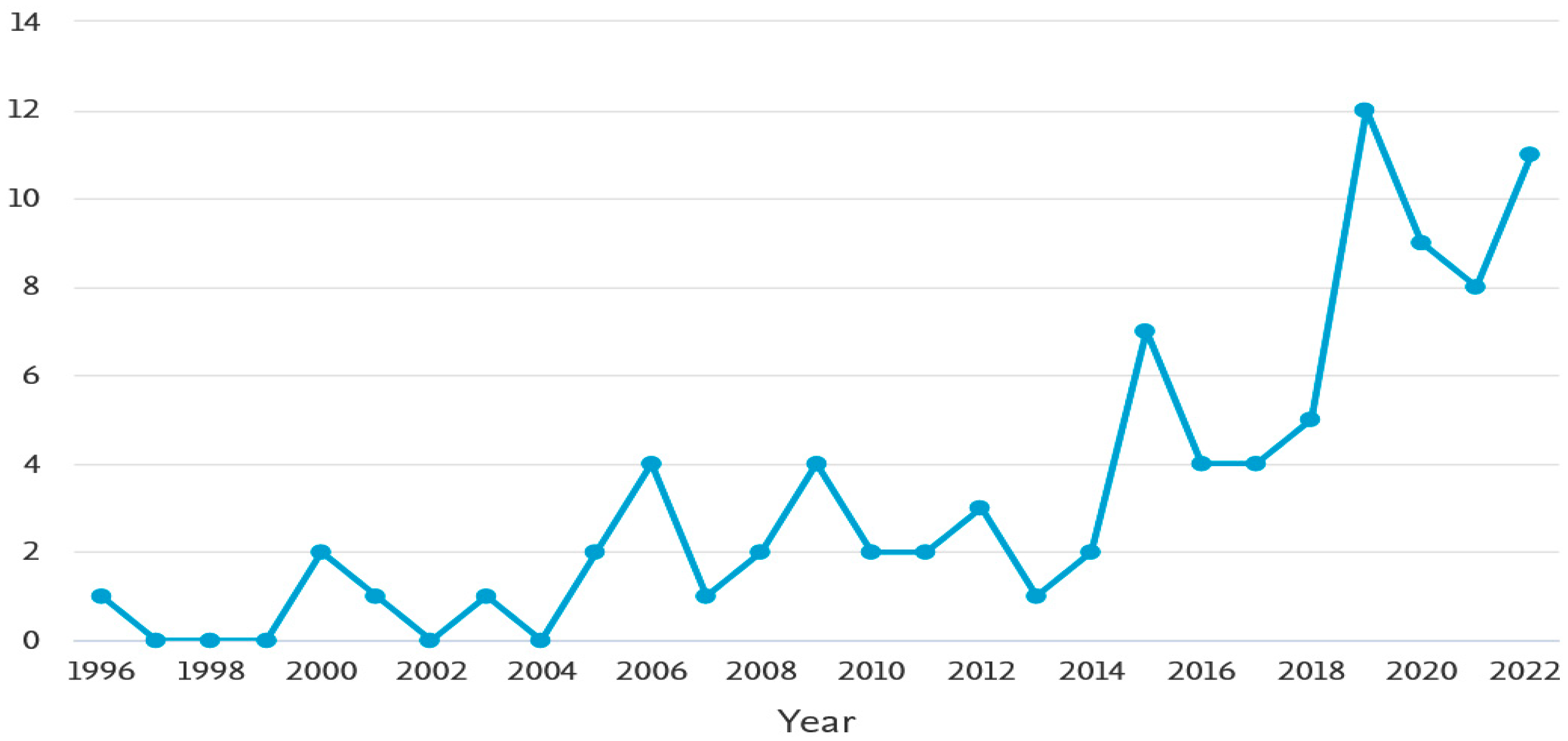
Figure 2.
Proportion of publications per country.
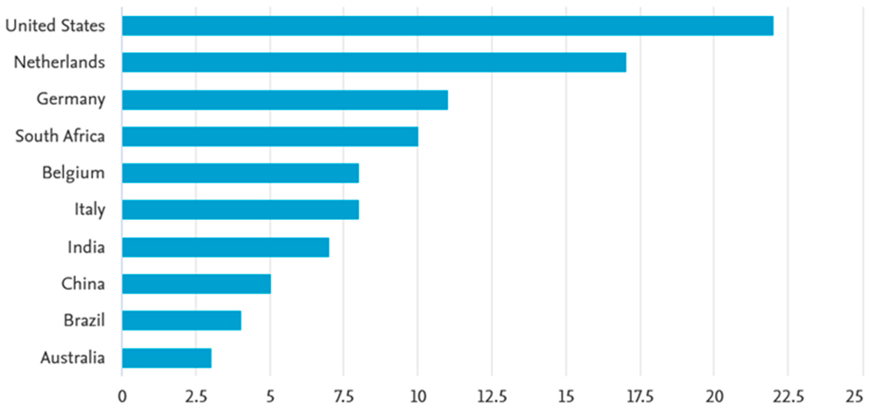
Figure 3.
Top funders of research on informal settlement mapping.

Table 1.
Description of informal settlement detection methods.
| Method | Description |
|---|---|
| Manual digitization | This method is time-consuming and resource-intensive; however, it yields more accurate results compared to other informal settlement detection methodologies [15]. |
| Pixel-based classification | This method results in high confusion between informal settlements and features with similar spectral signatures [24]. |
| Machine learning | This method can be used with other image classification techniques, such as OBIA, and texture [17,18]. |
| Texture-based classification | This methodology can easily be transferred to other areas with similar characteristics [25]. |
| OBIA | This methodology classifies image objects using contextual, spatial and spectral features [21]. |
Disclaimer/Publisher’s Note: The statements, opinions and data contained in all publications are solely those of the individual author(s) and contributor(s) and not of MDPI and/or the editor(s). MDPI and/or the editor(s) disclaim responsibility for any injury to people or property resulting from any ideas, methods, instructions or products referred to in the content. |
© 2023 by the authors. Licensee MDPI, Basel, Switzerland. This article is an open access article distributed under the terms and conditions of the Creative Commons Attribution (CC BY) license (https://creativecommons.org/licenses/by/4.0/).
Share and Cite
MDPI and ACS Style
Mudau, N.; Mhangara, P. Mapping and Assessment of Housing Informality Using Object-Based Image Analysis: A Review. Urban Sci. 2023, 7, 98. https://doi.org/10.3390/urbansci7030098
AMA Style
Mudau N, Mhangara P. Mapping and Assessment of Housing Informality Using Object-Based Image Analysis: A Review. Urban Science. 2023; 7(3):98. https://doi.org/10.3390/urbansci7030098
Chicago/Turabian StyleMudau, Naledzani, and Paidamwoyo Mhangara. 2023. "Mapping and Assessment of Housing Informality Using Object-Based Image Analysis: A Review" Urban Science 7, no. 3: 98. https://doi.org/10.3390/urbansci7030098