Impact of Climate Change on Irrigation Need and Groundwater Resources in Pinios Basin †


1
Hellenic Agricultural Organization, Soil and Water Resources Institute, 57400 Sindos, Greece
2
Forschungzentrum Juelich GmbH, Agrosphere Institute (IBG-3), D-52425 Juelich, Germany
*
Author to whom correspondence should be addressed.
†
Presented at the 3rd EWaS International Conference on “Insights on the Water-Energy-Food Nexus”, Lefkada Island, Greece, 27–30 June 2018.
Proceedings 2018, 2(11), 659; https://doi.org/10.3390/proceedings2110659
Published: 3 August 2018
(This article belongs to the Proceedings of EWaS3 2018)
Abstract
:Initially an area-differentiated modelling of groundwater recharge in River Pinios Basin (Greece) was carried out for the reference period 1971–2000 based on the mGROWA model. Subsequently, the model was applied to assess the impacts of climate change on groundwater recharge and irrigation need. For this purpose one bias-corrected RCM–GCM combination from the EURO-CORDEX ensemble of climate models for two emission scenarios (RCP 4.5 and RCP 8.5) have been used as input data for the projected periods 2011–2040 and 2040–2070 and 2700–2100. Results of the mGROWA model runs for the projected periods and the two emission scenarios indicate a different evolution of groundwater recharge and a general increase in irrigation need, however with different degrees of intensity.
1. Introduction
Pinios Basin is considered as one of the highest productive regions of the country, located in Thessaly (central Greece) with total surface area of approximately 11,000 km2. In the plain areas of Pinios Basin, intensive agricultural activities caused pressures on water resources. Over 85% of the totally available water resources (both surface and groundwater) are used by agricultural activities. Groundwater levels are strongly controlled by the seasonal exploitation of the resources over the summer irrigation period, mainly exercised by numerous shallow but mainly deep wells that reach 400 m. According to the latest official water resources management plans compiled in accordance to EU-WFD, a number of water bodies are risk of failing good status, or are already in poor status [1].
Due to lack of coordinated water resources management policies in the past, signs of over-exploitation were documented and a notable negative water balance has been established in the last 3 decades [2]. In an attempt to restore documented quality and quantity issues, the Hellenic Special Secretariat for Water has approved an integrated management plan for the river basin [1]. Nevertheless, a detailed and updated area differentiated quantification of the renewable groundwater quantities (i.e., groundwater recharge), has not been provided so far although these water quantities are needed for the implementation of a sustainable water resources management plan. This lack of information is attempted to be covered via the application of the water balance model mGROWA [3] in Pinios river basin.
The first goal of this publication is the determination of the mean long-term renewable groundwater recharge (status quo analyses) and their further development until 2100 (climate change impact assessment). The second goal is the determination of the crop specific irrigation need and its further development.
Both issues have become more important during the last years, on one hand as a prerequisite for adapting the actual groundwater management in Pinios river basin to the renewable ground water quantities. On the other hand, taking possible climate change induced projections of the renewable groundwater volumes into account, may support the development of a sustainable groundwater resources management plan, which adapts future water use and demand to the future renewable groundwater quantities.
2. Study Area
Pinios Basin is characterized by highly diversified geological, hydrological and hydrogeological conditions. The climate is typical Mediterranean [2]. Mean annual precipitation is about 700 mm and mean annual temperature is 14.6 °C. Precipitation is distributed mostly during the cold season, without any significant precipitation during the hot summer at the plains of the basin. The basin is sub-divided to the western and the eastern sub-basins that are separated by a hilly region structured of Neogene marls with intercalations of fine sandstones and to a minor extent limestones. A rugged topographic relief that reaches altitudes of over 2000 m bounds the basin, whereas the plains are characterized of quasi-flat topographic surfaces that extend from almost 200 m down to the sea-level. Due to the active fault tectonics a great thickness of alluvia has been deposited that exceeds 450 to 500 m towards the central parts and progressively thin out at the margins. Groundwater resources exploitation is focused on the peripheral alluvial basins, and also on the karstified systems.
3. Methods
3.1. The mGROWA Model for Determining Groundwater Recharge Rates
The mGROWA model [3] has been developed for determining water balance variables including groundwater recharge in large areas (river basins, Federal States etc.) under present and possible future climate conditions. The mGROWA modelling concept was rigorously aligned to both, the spatial resolution of the data commonly available for hydrological modelling and the necessity to obtain spatially and temporally highly resolved patterns of water balance variables for the local and regional groundwater management. The spatial resolution of mGROWA simulations is arbitrary.
According to the categorization schema of Becker & Serban [4], mGROWA can be classified as a deterministic grid-based distributed hydrological water balance model. This implies a description of hydrological processes reflecting the fundamental laws of physics (in particular hydro- and thermodynamics) in a simplified, approximate manner. In addition this concept involves in general a certain degree of empiricism.
The mGROWA modelling approach comprises several sequential parts. Within the basic part, the hydrological processes at the earth’s surface and in the root zone of soil are simulated. In particular, soil moisture dynamics including percolation water movement, capillary rise from ground water to the root zone, actual evapotranspiration and total runoff generation are calculated in daily time steps. For the simulation of soil moisture dynamics, the multi-layer soil water balance model BOWAB [5] is integrated.
Actual evapotranspiration is calculated based on the Penman-Monteith grass reference evapotranspiration equation [6,7], land-use and crop specific coefficients [5], a topography correction function and the Disse-equation for taking the soil moisture dependency of evapotranspiration into account [8]. Additionally, mGROWA calculates the water balance for impervious surfaces (e.g., sealed surfaces in urban areas) and open water surfaces using approaches adapted to the specific storage characteristics, respectively.
The runoff separation part deals with runoff components such as natural interflow in hard rock aquifers, drainage runoff from artificially drained agricultural land and groundwater recharge which are separated from the total runoff by using the empirical approach of Base Flow Indices (BFI). The concept of BFI-values has been successfully used in several studies in Europe, e.g., in applications of the GROWA/mGROWA modelling approach [9,10,11] or the hydrological model ARC/EGMO [12]. The idea behind the BFI-approach is that characteristic site conditions are decisive for the shares of runoff components and groundwater recharge in total runoff. In order to allocate a site-specific BFI-value to each single grid cell, a hierarchical approach as proposed by [13] is used. The runoff components and groundwater recharge rates are commonly aggregated to monthly or annual mean values as groundwater management doesn’t require a higher temporal resolution.
3.2. Assessing Crop-Specific Irrigation Needs
Several agricultural drought statistics can be optionally calculated using the mGROWA model. Irrigation need is determined for individual crops. For this purpose crop specific irrigation rules have been implemented to ensure on one hand economically justified expenses for irrigation water supply and on the other hand soil water contents at a plant-physiological level that allow the expectation of maximal or optimal crop yields under the given environmental conditions. The simulation of field crop specific irrigation need uses the simulated soil moisture status information and predefined irrigation rules, which have been derived from personal communication with local farmers and a study by Pisinaras et al. [14]. The following rules and constraints are implemented in mGROWA:
- Optimal water supply of field crops is assumed, i.e., limitations for irrigation (e.g., a maximal yearly water budget) are neglected.
- The minimal soil water content that initiates irrigation (in % eff. field capacity) varies with crop and the seasonally variable depths of the root zone month.
- The soil water content at which irrigation stops is fixed for all crops to 80% eff. field capacity.
- The maximum irrigation volume per day is supposed to be 30 mm for all field crops.
- Irrespective of the actual soil water content irrigation is omitted if precipitation exceeds 5 mm at a particular day. (in mm),
- The irrigation period is defined annually and comprises the period between the first day and the last day irrigation (indicated by ripening or harvesting) is needed
- The minimum precipitation level per day indicating the omission of irrigation (in order to exceed canopy interception of precipitation water),
3.3. Selection of RCP (Representative Concentration Pathways) for Climate Change Impact Assessment
Climate projections are commonly performed as ensemble simulations in which different RCPs (Representative concentration pathways describing possible global climate futures depending on greenhouse gas emissions), GMCs (global climate models) and RCMs (regional climate models) are combined and linked to a water balance model. In this paper just one GCM–RCM combination (ICHEC-EC-EARTH r3i1p1-HIRHAM5) & mGROWA has been considered based on the two fundamentally different RCP 4.5 and RCP 8.5 from the available EURO-CORDEX ensemble [15]. Whereas the RCP 4.5 represents a “moderate warm” future, the RCP 8.5 represents a “very warm” future.
4. Results
4.1. Groundwater Recharge and Irrigation Need for the Reference Period 1971–2000
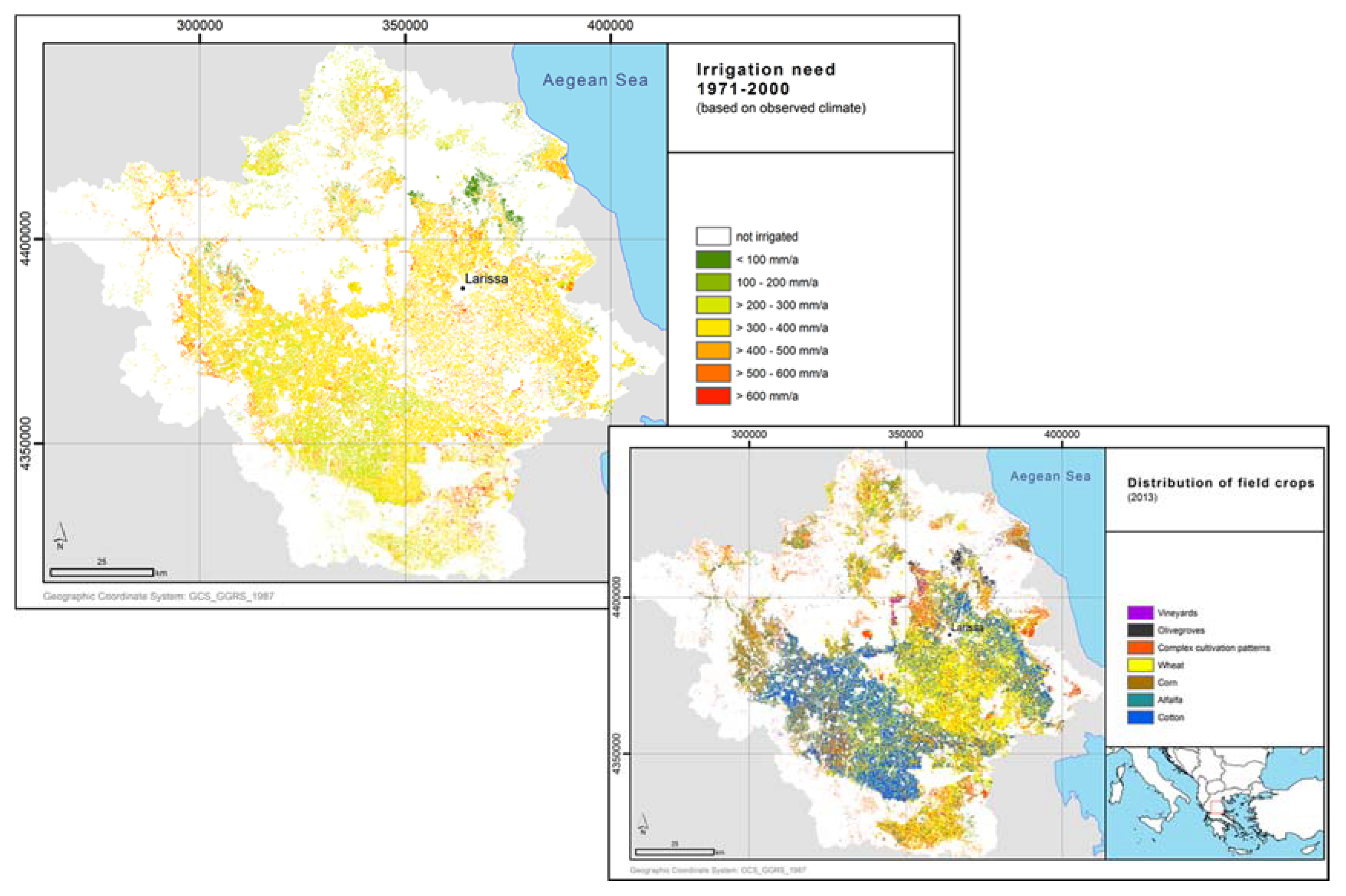
Groundwater recharge was determined for the reference period 1971–2000 in a spatial resolution of 100 m by 100 m. The long-term annual groundwater recharge levels shown in Figure 1 vary between <25 mm/a and >300 mm/a and indicate the upper limit of the renewable groundwater quantity which can contribute to the replenishment of the water systems and the coverage of regional water demands, amongst which irrigation is by far the largest. Overall, a decreasing trend is captured from the mountainous to the plains areas and also from the west to the east, which is in good agreement with the analyzed distribution of precipitation and evapotranspiration. In general, low levels of groundwater recharge (less than 200 mm/y) occur at nearly 70% of the total Pinios basin.
The reliability of the calculated area-differentiated runoff levels was validated by comparing real long-term (measured) discharge values with the ones calculated by GROWA model for 12 gauging stations that exhibit a fair spatial distribution over the study area. The measure of validity was based on the coefficient of determination (R2) between these two values which is nearly 0.92 indicating satisfactory matching between observed and simulated discharge values.
The prevailing field crops in Pinios basin are wheat, corn, alfalfa, cotton, olive groves, and vineyards, their the spatial distribution in Pinios basin in the year 2013 is represented in Figure 2 (right side). Figure 2 (upper left side) shows the related crop specific irrigation need. In most of the areas concerned the average annual irrigation need varies between 200 and 400 mm/a, thus illustrating to what extent irrigation exceeds the in situ groundwater recharge rates (Figure 1).
4.2. Projections of Possible Groundwater Recharge Rates and Irrigation Need Until 2100
For the subsequent mGROWA model runs projecting the future development of groundwater recharge and irrigation need, the crop distribution 2013 is assumed to be stationary so that crop rotation is neglected. This procedure however has the advantage that the changes in groundwater recharge and irrigation need respectively are reflecting the impact of climate change exclusively.
4.2.1. Projected Change of Groundwater Recharge
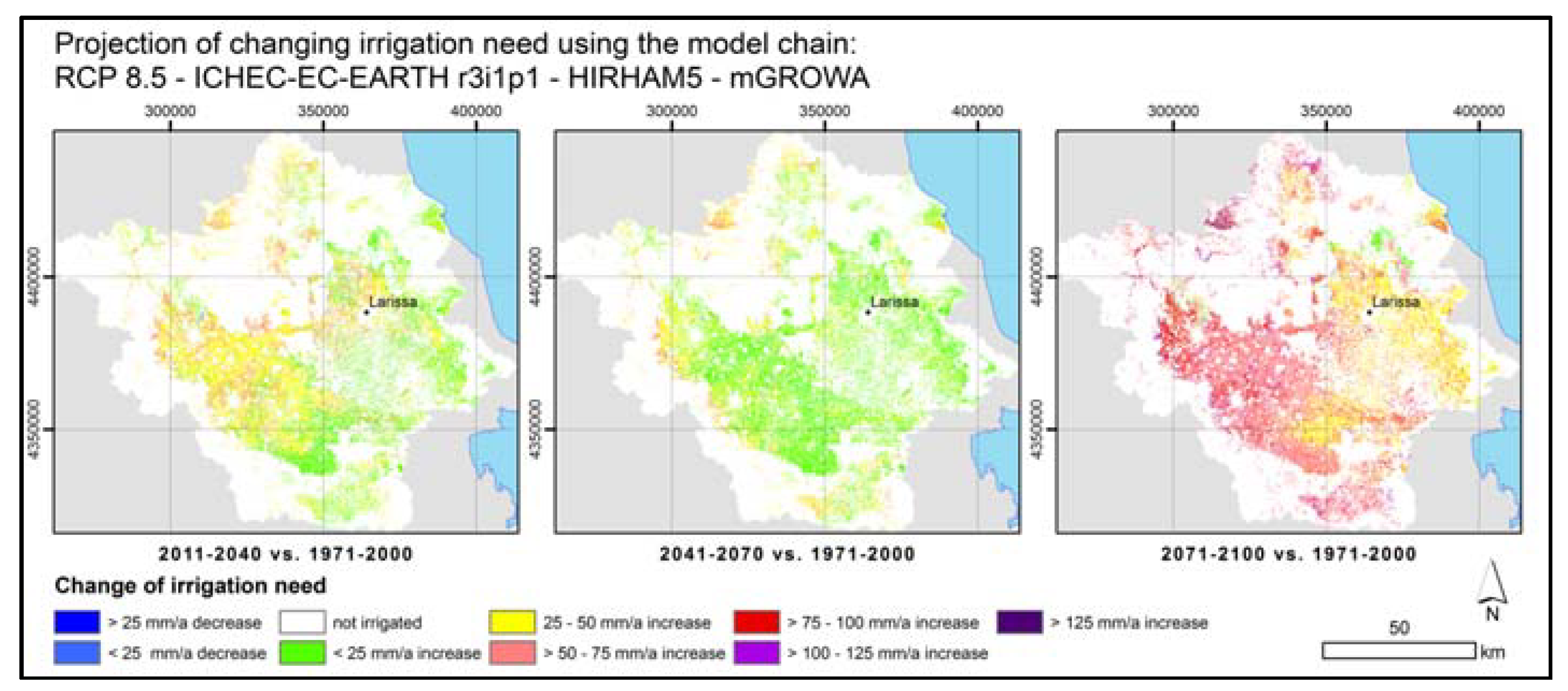
Figure 3 shows the projected evolution of groundwater recharge in Pinios basin using the model chain ICHEC-EC-EARTH r3i1p1-HIRHAM5—mGROWA under RCP 4.5. The maps show the deviation of modelled groundwater recharge rates of the time slots 2011–2040, 2041–2070 and 2071–2100 from the reference period 1971–2000 in per cent. Figure 4 shows the results for the same model set-up, however based on the RCP 8.5.
The projected change of groundwater recharge assessed based on RCP 4.5 (representing a “moderate warm future”) shows considerable differences amongst the three time slots (see Figure 3). In the period 2011–2040 groundwater recharge rates initially increases up to 25% and more in large parts of the Eastern and Western Thessaly basin as well as in the South–western parts of Pinios mountain ranges, whereas other regions show a decrease up to 25%. The time period 2041–2071 is characterized by an overall reduction of groundwater recharge. Decreasing groundwater recharge rates up to 25% are wide-spread and can exceed 50% in Titarisios basin. For the time period 2071–2100 the RCP 4.5 implies increasing groundwater recharge rates again for the Eastern and Western Thessaly basin. On the whole, the groundwater recharge patterns are comparable to the ones determined for the period 2011–2040 again.
The model run based on RCP 8.5 (representing a “very warm future”) shows the opposite tendency compared to the results of the RCP 4.5 model run. Additionally, the differences between the projected changes of groundwater recharge for the three time slots are more pronounced. In the period 2011–2040 groundwater recharge rates initially decrease almost area-covering up to 25% and 50% respectively. The time period 2041–2071, is characterized by an overall significant increase of groundwater recharge which can exceed 50% in the central part of Pinios basin. For the time period 2071–2100 the model run based on the RCP 8.5 implies increasing groundwater recharge rates for the Eastern Thessaly basin, whereas declining groundwater recharge rates up to 50% are projected in the remaining parts of the basin. Even though the greenhouse gas emissions of the possible global futures assumed in the RCPs 4.5 and 8.5 are completely different, the groundwater recharge patterns assessed for the period 2071–2100 are quite comparable.
4.2.2. Projected Change of Irrigation Need
Figure 5 shows the projected evolution of irrigation need in Pinios basin using the model chain RCP 4.5-ICHEC-EC-EARTH r3i1p1-HIRHAM5—mGROWA. The maps show the deviation of modelled irrigation needs of the time slots 2011–2040, 2041–2070 and 2071–2100 from the reference period 1971–2000 in per cent. Figure 6 shows the results for the same model set-up, however based on the RCP 8.5.
The projected change of irrigation need based on RCP 4.5 shows differences amongst the three time slots (see Figure 5), the overall tendency however is the same independent of the time period. Large parts of the Eastern Thessaly basin show a significant increasing irrigation demand of up to 75% and more, most of all south of Larissa. The Western part of Thessaly basin shows increasing irrigation demands too, but less profound (up to max. 50% in the period 2071–2100)
The model run based on RCP 8.5 (Figure 6) correlates in the period 2011–2070 with the projected evolution of groundwater recharge shown in Figure 6.
Accordingly irrigation need in the period 2011–2040 decreases with increasing groundwater recharge rates, whereas irrigation need decreases in the time period 2041–2071, for which an overall significant increase of groundwater recharge has been projected. For the time period 2071–2100 however significantly increasing irrigation needs (>75%) have been projected, although the decrease in groundwater recharge is less profound.
5. Discussion and Conclusions
mGROWA model results provide a reasonable overview of the actual mean groundwater recharge and irrigation need (1971–2000). In the context of climate change impact assessments, the model results can be of utmost importance, as they provide a representative measure for the available groundwater quantities usable for irrigation purposes under climate change conditions. The projected climate effects on groundwater recharge generation can be used for long-term strategic planning of groundwater resources as they are an appropriate framework to design and implement an integrated set of measures in the direction of adaptation and preparedness, so that the anticipated impacts from climate change can be minimized and controlled in due time.
The results of the “one and only” GCM–RCM combination & mGROWA considered so far for the projected period (2011–2100) under RCP 4.5 and RCP 8.5 scenarios have revealed considerable differences in the water qualities assessed. Whereas the evolution of groundwater recharge shows a continuous decrease until 2071, followed by an increase after 2071 in case RCP 4.5 is applied, the application of RCP 8.5 results in a significant decrease of groundwater recharge until 2041, followed by a significant increase until 2071 and another decrease again until 2100.
The same GCM–RCM combination & mGROWA implies general increasing irrigation needs, but of different degrees of intensity. Whereas results based on RCP 4.5 indicate generally slight increasing irrigation needs and a significant increase in eastern Thessaly basin, the RCP 8.5 generally indicates a slight increase until 2071, followed by a significant increase until 2100.
The partly contradictory model results are due to the fact that RCP 4.5 and RCP 8.5 have been selected intentionally as they describe varying possible global climate futures depending on varying greenhouse gas emissions. Therefore the model results presented here should not be “over-interpreted”. In order to assess the climate change impact with more accuracy and to incorporate the uncertainty induced by climate models, and therefore to provide key indicators for groundwater management, it is necessary to run all 45 GCM–RCM combinations of the EURO-CORDEX ensemble [14] & mGROWA.
The robustness of the assessed groundwater recharge rates and the irrigation needs respectively will be improved by overcoming actual input data lacks. This includes a lack of climate data and related time series, a lack of soil and vegetation specific evapotranspiration parameters and soil moisture distributions respectively and a lack of data about subsurface lateral water influx (groundwater recharge and interflow) into the alluvial deposits in the plains.
Against this background it is part of the overall strategy of a research cooperation between the Hellenic Agricultural Organization, Soil and Water Resources Institute and Forschungzentrum Juelich GmbH, Agrosphere Institute (IBG-3) to set up a hydrologic observatory in Agia basin, a 44 km2 sub-catchment of Pinios River basin. In this test site state-of-the-art devices are installed with the aim to improve the climatic data base, to determine vegetation specific evapotranspiration parameters and to quantify the lateral groundwater inflow into the basin from adjacent mountainous areas. The parameters derived and lateral groundwater flow rates assessed with the help of the state-of-the-art devices will then additionally be used in the entire Thessaly basin, e.g., in the model-based assessment of sustainably available groundwater resources based on the mGROWA model.
References
- Hellenic Ministry for the Environment, Energy and Climate Change-Special Secretariat for Water. Compilation of Management Plan for the River Basins of Thessaly Water District (GR08)-Management Plan; Athens, Greece, 2014; 252p. [Google Scholar]
- Alexandridis, T.K.; Panagopoulos, A.; Galanis, G.; Alexiou, I.; Cherif, Y.; Chemin, Y.; Stavrinos, E.; Bilas, G.; Zalidis, G.C. Combining remotely sensed surface energy fluxes and GIS analysis of groundwater parameters for irrigation system assessment. J. Irrig. Sci. 2014, 32, 127–140. [Google Scholar] [CrossRef]
- Herrmann, F.; Keller, L.; Kunkel, R.; Vereecken, H.; Wendland, F. Determination of spatially differentiated water balance components including groundwater recharge on the Federal State level—A case study using the mGROWA model in North Rhine-Westphalia (Germany). J. Hydrol. Reg. Stud. 2015, 4, 294–312. [Google Scholar] [CrossRef]
- Becker, A.; Serban, P. Hydrological Models for Water-Resources System Design and Operation; World Meteorological Organisation: Geneva, Switzerland, 1990. [Google Scholar]
- Engel, N.; Müller, U.; Schäfer, W. BOWAB-Ein Mehrschicht-Bodenwasserhaushaltsmodell. GeoBerichte Landesamt Bergbau. Energ. Geol. 2012, 20, 85–98. [Google Scholar]
- Allen, R.G.; Pereira, L.S.; Raes, D.; Smith, M. Crop Evapotranspiration-Guidelines for Computing Crop Water Requirements; FAO-Food and Agriculture Organization of the United Nations: Rome, Italy, 1998. [Google Scholar]
- Monteith, J.L. Evaporation and environment. Symp. Soc. Expt. Biol. 1965, 19, 205–234. [Google Scholar]
- Disse, M. Modellierung der Verdunstung und der Grundwasserneubildung in Ebenen Einzugsgebieten; Fakultät für Bauingenieur- und Vermessungswesen der Universität Fridericiana zu Karlsruhe: Karlsruhe, Germany, 1995. [Google Scholar]
- Ehlers, L.; Herrmann, F.; Blaschek, M.; Duttmann, R.; Wendland, F. Sensitivity of mGROWA-simulated groundwater recharge to changes in soil and land use parameters in a Mediterranean environment and conclusions in view of ensemble-based climate impact simulations. Sci. Total Environ. 2016, 543, 937–951. [Google Scholar] [CrossRef] [PubMed]
- Wendland, F.; Kunkel, R.; Tetzlaff, B.; Dörhöfer, G. GIS-based determination of the mean long-term groundwater recharge in Lower Saxony. Environ. Geol. 2003, 45, 273–278. [Google Scholar] [CrossRef]
- Tetzlaff, B.; Andjelov, M.; Kuhr, P.; Uhan, J.; Wendland, F. Model-based assessment of groundwater recharge in Slovenia. Environ. Earth Sci. 2015, 74, 6177–6192. [Google Scholar] [CrossRef]
- Haberlandt, U.; Klöcking, B.; Krysanova, V.; Becker, A. Regionalisation of the base flow index from dynamically simulated flow components-a case study in the Elbe River Basin. J. Hydrol. 2001, 248, 35–53. [Google Scholar] [CrossRef]
- Kunkel, R.; Wendland, F. The GROWA98 model for water balance analysis in large river basins-the river Elbe case study. J. Hydrol. 2002, 259, 152–162. [Google Scholar] [CrossRef]
- Pisinaras, V.; Paraskevas, C.; Ilias, A.; Panagopoulos, A.; Arampatzis, G.; Alexiou, I.; Kotsopoulos, S.; Poulos, S.; Nastos, P. Investigation of Climate Change Effects in Agricultural Water Management of Pinios River Delta, Central Greece. In Proceedings of the 9th World Congress of European Water Resources Association, Istanbul, Turkey, 10–13 June 2015. [Google Scholar]
- Van Vuuren, D.P.; Edmonds, J.; Kainuma, M.; Riahi, K.; Thomson, A.; Hibbard, K.; Hurtt, G.C.; Kram, T.; Krey, V.; Lamarque, J.-F.; et al. The representative concentration pathways: An overview. Clim. Chang. 2011, 109, 5–31. [Google Scholar] [CrossRef]
Figure 1.
Average groundwater recharge in Pinios River basin (1971–2000) based on mGROWA.

Figure 2.
Average irrigation need in Pinios River basin (1971–2000) based on mGROWA.

Figure 3.
Projected evolution of groundwater recharge in Pinios basin using the model chain ICHEC-EC-EARTH r3i1p1-HIRHAM5—mGROWA under RCP 4.5.
Figure 3.
Projected evolution of groundwater recharge in Pinios basin using the model chain ICHEC-EC-EARTH r3i1p1-HIRHAM5—mGROWA under RCP 4.5.

Figure 4.
Projected evolution of groundwater recharge in Pinios basin using the model chain ICHEC-EC-EARTH r3i1p1-HIRHAM5—mGROWA under RCP 8.5.
Figure 4.
Projected evolution of groundwater recharge in Pinios basin using the model chain ICHEC-EC-EARTH r3i1p1-HIRHAM5—mGROWA under RCP 8.5.

Figure 5.
Projected evolution of irrigation need in Pinios basin using the model chain ICHEC-EC-EARTH r3i1p1-HIRHAM5—mGROWA under RCP 4.5.
Figure 5.
Projected evolution of irrigation need in Pinios basin using the model chain ICHEC-EC-EARTH r3i1p1-HIRHAM5—mGROWA under RCP 4.5.

Figure 6.
Projected evolution of irrigation need in Pinios basin using the model chain ICHEC-EC-EARTH r3i1p1-HIRHAM5—mGROWA under RCP 8.5.
Figure 6.
Projected evolution of irrigation need in Pinios basin using the model chain ICHEC-EC-EARTH r3i1p1-HIRHAM5—mGROWA under RCP 8.5.

Publisher’s Note: MDPI stays neutral with regard to jurisdictional claims in published maps and institutional affiliations. |
© 2018 by the authors. Licensee MDPI, Basel, Switzerland. This article is an open access article distributed under the terms and conditions of the Creative Commons Attribution (CC BY) license (https://creativecommons.org/licenses/by/4.0/).
Share and Cite
MDPI and ACS Style
Panagopoulos, A.; Herrmann, F.; Pisinaras, V.; Wendland, F. Impact of Climate Change on Irrigation Need and Groundwater Resources in Pinios Basin. Proceedings 2018, 2, 659. https://doi.org/10.3390/proceedings2110659
AMA Style
Panagopoulos A, Herrmann F, Pisinaras V, Wendland F. Impact of Climate Change on Irrigation Need and Groundwater Resources in Pinios Basin. Proceedings. 2018; 2(11):659. https://doi.org/10.3390/proceedings2110659
Chicago/Turabian StylePanagopoulos, Andreas, Frank Herrmann, Vassilios Pisinaras, and Frank Wendland. 2018. "Impact of Climate Change on Irrigation Need and Groundwater Resources in Pinios Basin" Proceedings 2, no. 11: 659. https://doi.org/10.3390/proceedings2110659