
A Seismo-Stratigraphic Analysis of the Relict Deposits of the Cilento Continental Shelf (Southern Italy) †


1
Istituto di Scienze Marine (ISMAR), Consiglio Nazionale delle Ricerche (CNR), 80133 Napoli, Italy
2
Istituto Nazionale di Geofisica e Vulcanologia (INGV), Sezione Osservatorio Vesuviano (OV), Via Diocleziano 328, 80125 Napoli, Italy
*
Author to whom correspondence should be addressed.
†
Presented at the 4th International Electronic Conference on Geosciences, 1–15 December 2022; Available online: https://sciforum.net/event/IECG2022 .
Proceedings 2023, 87(1), 10; https://doi.org/10.3390/IECG2022-14296
Published: 30 March 2023
(This article belongs to the Proceedings of The 4th International Electronic Conference on Geosciences)
Abstract
:The relict (palimpsest and lowstand) deposits of the Cilento continental shelf were analyzed based on the geological interpretation of Sub-Bottom Chirp sections, calibrated with core data. A progradational unit, which is overlying the acoustic basement, is interpreted as the beach deposits of the isotopic stages 4 and 5. This unit is overlain by a seismo-stratigraphic unit, which is composed of coarse-grained organogenic sands and interpreted as relict sands. This unit consists of sandy ridges, occurring at water depths ranging between 130 and 140 m, and was interpreted as an example of submerged beach deposits, genetically related to the marine isotopic stage 2 (Last Glacial Maximum; starting date 29 ky B.P.).
1. Introduction
The seismo-stratigraphic analysis of the relict deposits of the Cilento continental shelf (Southern Tyrrhenian Sea, Italy) based on the geological interpretation of Sub-Bottom Chirp sections is herein presented [1]. Two types of relict deposits, i.e., the palimpsest deposits and the lowstand deposits, were identified.
The unconsolidated sedimentary cover of the continental shelf comprises two types of sediments: those that are not in equilibrium with current environmental conditions (i.e., in a broad sense, relict sediments) and those in equilibrium with these conditions. Based on the classical definition devised by Emery [2], the relict sediments were deposited long ago, in equilibrium with the depositional environments; therefore, while later, these depositional environments are no longer in equilibrium, even though they were not covered by subsequent sediments. An important feature in recognizing the relict origin of a sediment is the occurrence of coarse-grained sands, which are located at a greater distance from the coast and at greater depths than fine-grained sands. Another important concept is that of the palimpsest sediments, which have characteristics of two sedimentary environments: one environment is older and one environment is more modern. While the relict sediments represent remnants of previous depositional environments, the palimpsest sediments correspond with relict sediments, which were subsequently reworked.
The relict deposits of the Mediterranean continental shelves were investigated in detail. Albarracin et al. [3] studied the relict sand waves located on the continental shelf of the Gulf of Valencia, which is located in the Western Mediterranean. The system of sand waves is located in front of the present-day Albufera de Valencia lagoon and is composed of twenty-seven ridges, which have a NNE-SSW trending. The seismo-stratigraphic interpretation and the construction of curves of relative sea-level changes showed that the sand waves were formed during the Younger Dryas period (12–10 ky B.P.), allowing for their classification as Holocene sand waves. Bassetti et al. [4] studied the relict sands offshore from the Gulf of Lions, which is located near France. The sedimentary succession overlies the major erosional discontinuity related to emersion of the continental shelf during the Last Glacial Maximum (LGM). It consists of basal transgressive deposits, which were subsequently reworked, on the outer shelf, into dunes and sand ridges, overlying the regressive prograding body. Fernández-Salas et al. [5] studied the morphology and the characterization of the relict facies on the internal continental shelf in the Gulf of Cadiz (Spain). The analysis of the obtained data showed that the relict facies beaches and coastal barriers are associated with the coastal spits located in the ancient outlets of the rivers. Pennetta et al. [6] searched for the relict sands on the Cilento continental shelf aimed at beach nourishments. The sedimentological analyses allowed for the detection of the continental shelf; at water depths ranging between 20 and 50 m (except for the Gulf of Policastro), the occurrence of deposits was mainly composed of middle-to-fine-grained sands, which were overlain by a pelitic drape. These deposits are often associated with Posidonia oceanica meadows and coarse-grained sands in a maërl facies [7]. The maërl facies is a lithofacies composed of calcareous algae, both whole and fragmented, the occurrence of which is controlled via peculiar hydrodynamic and sedimentary conditions.
2. Geologic Setting
A sector of the south-eastern Tyrrhenian margin encloses the Cilento continental shelf, which constitutes the morpho-structural high of the Cilento Promontory, and is bounded northwestwards by the Gulf of Salerno–Sele Plain basin and southeastwards by the Gulf of Policastro basin, which are both subsiding. This passive margin, which is genetically related to the extensional phases of the south-eastern Tyrrhenian sector that occurred during the Late Pliocene–Pleistocene period, is involved via listric faults, controlling the individuation of lowered areas on the continental shelf [8,9,10].
The structure of Cilento was previously investigated through multichannel seismic data [11,12,13,14,15]. These data showed the stratigraphic architecture of the Campania margin from the Salerno offshore towards the structural high of the Cilento continental shelf. Early-Middle Pleistocene marine deposits, representing the bulk of the basin filling, which was strongly deformed due to normal faulting and cropping out at the sea bottom in correspondence to main erosional areas, represent the first seismo-stratigraphic unit. The second unit consists of Late Pleistocene marine and coastal deposits, which are relatively undeformed and are characterized by progradational geometries in correspondence to the Cilento structural high and parallel geometries in the Salerno offshore.
The Cilento district, in its emerging portion, is one of the most complex areas of the Southern Apennines. In particular, the outcropping successions consist of a set of terrigenous units, which are composed of basin turbidites (Flysch del Cilento Auct.) and a carbonate platform unit (Alburno Cervati carbonate unit) [10,16,17,18] (Figure 1). Plio-Pleistocene and Holocene deposits of the Cilento continental shelf overlie an acoustic substratum, which is genetically related to the Cilento Flysch (ssi unit in seismic profiles) [6,19,20,21,22].
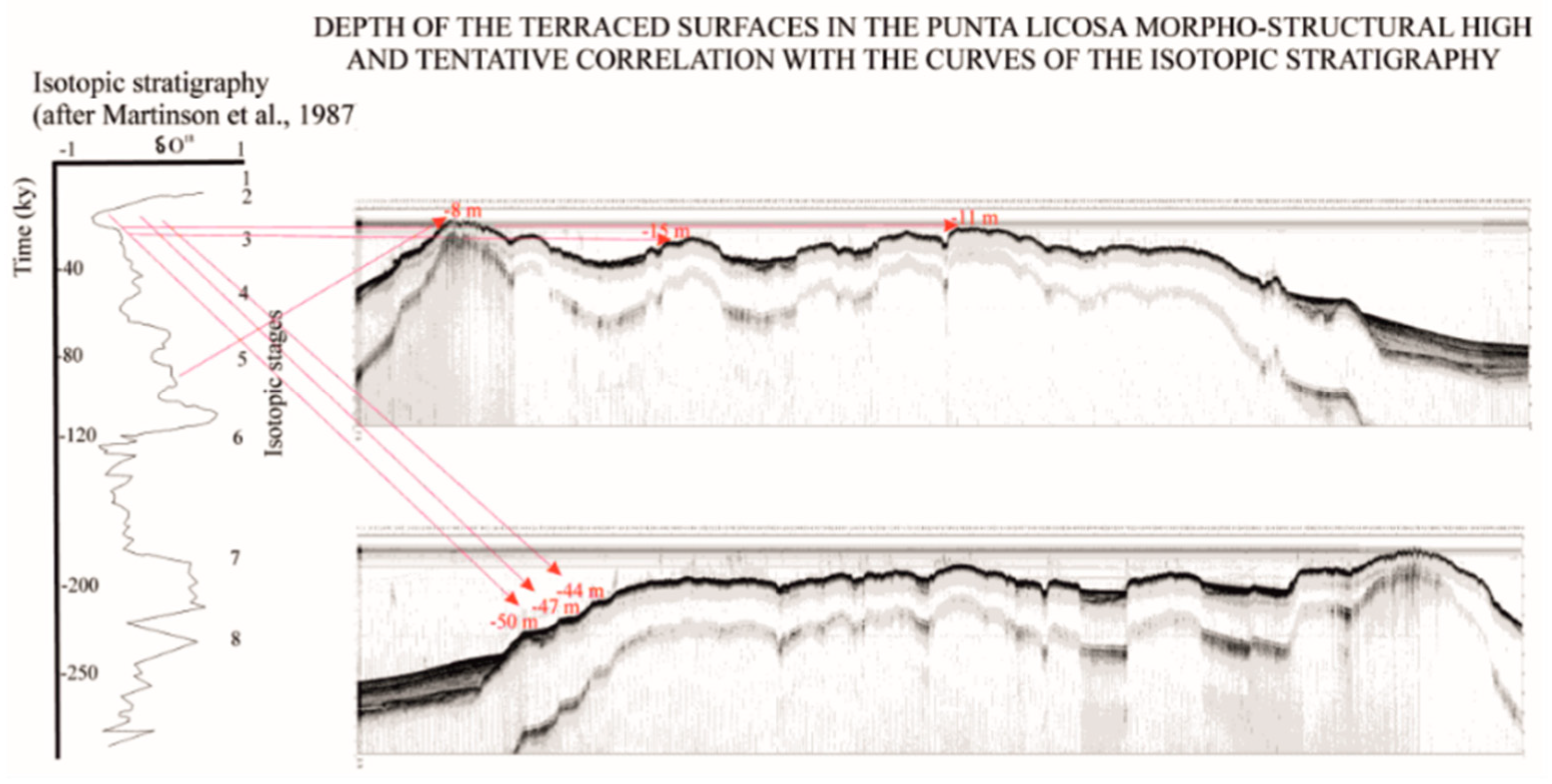
At the sea bottom, the rocky acoustic basement, which is recognized via these seismo-acoustic data, crops out in the area surrounding the structural high of the Licosa Cape and is characterized by erosional morphologies, mainly consisting of terraced surfaces [21,23] (Figure 2). Aiello [21] revealed the depths of the marine terraces in the Cilento offshore based on the geological interpretation of Sub-Bottom Chirp data. Savini et al. [23] detected the offshore terraced landforms using geomorphometric techniques and grouped them properly based on the depth range of occurrence. The distribution of both onshore and offshore terraced landforms was reconstructed according to the geological units [23].
3. Materials and Methods
The research was carried out based on the geological interpretation of selected seismic sections (Sub-Bottom Chirp; Figure 3) [21,22]. The seismic data, which were recorded onboard with a SEG Y format, were processed using the software Seismic Unix [25]. A simple processing method was applied to the seismic sections of the Cilento offshore, consisting of the application of a linear vertical gain along the section, which allowed for a significant improvement in the quality of the processed data. The processing flux consisted of several steps, including the conversion of the traces from SEG Y to SU; the spectral analysis of the frequencies of the seismograms in order to reconstruct the distribution of the frequencies; the application of the Fast Fourier Transform (FFT) for the visualization and analysis of the frequencies of the signal; the application of a high-pass filter with a low-cut frequency at 150 Hz in order to eliminate the noise and the dark signal; the application of an uniform gain on each trace; the application of a Time Variant Gain (TVG) in order to improve both the signal of the deeper reflectors and the whole visualization of the entire profile; and the output of the seismic profiles with Seismic Unix in order to obtain the final files, the cartographic restitution of which was realized using a graphic interface.
Seismic data interpretation adopted seismo-stratigraphic criteria [26,27]. The basic principle of the seismic stratigraphy was that the seismic reflectors, which were determined through contrasts of acoustic impedance, corresponded to the strata plains. Furthermore, the geometry of the seismic reflectors corresponded to the depositional geometry (onlap, offlap, toplap, downlap), and depended on faults density and depositional features. The bedding planes represented the paleo-depositional surfaces and could be considered heritage structures to contemporary structural settings. The unconformities were paleo-erosional or non-depositional surfaces, corresponding with significant stratigraphic gaps. Catuneanu [28] deeply revised the sequence stratigraphic methods and concepts, proposing a workflow starting from the tectonic setting, moving through the interpretation of paleo-depositional environments and ending with the determination of the sequence stratigraphic framework (stratal terminations, stratigraphic surfaces, system tracts and sequences). The sequence models were outlined (depositional sequences, genetic stratigraphic sequences, transgressive–regressive sequences and para-sequences).
4. Results
The geomorphologic map was constructed in a GIS environment (Qgis: http://www.qgis.org; accessed on 29 March 2023) (Figure 4). The study area represents a wide continental shelf, the outer margin of which is located at water depths of 250 m. While the continental shelf northwards of the Licosa Cape has uniform gradient, the marine area surrounding the Licosa Cape represents an E–W trending structural high, characterized by remnants of terraced surfaces, which carves the rocky acoustic basement and is particularly abundant in the bathymetric interval ranging between 10 and 20 m, though it occurs in water depths of up to 60 m. An abrupt break in slope, which is located at water depths ranging between 60 and 80 m, marks the transition from the structural high of the Licosa Cape to the outer shelf through a steep slope. Toward the Gulf of Policastro, the continental shelf is characterized by an articulated morphology and high gradients and shows water depths ranging between 10 m and 110 m.
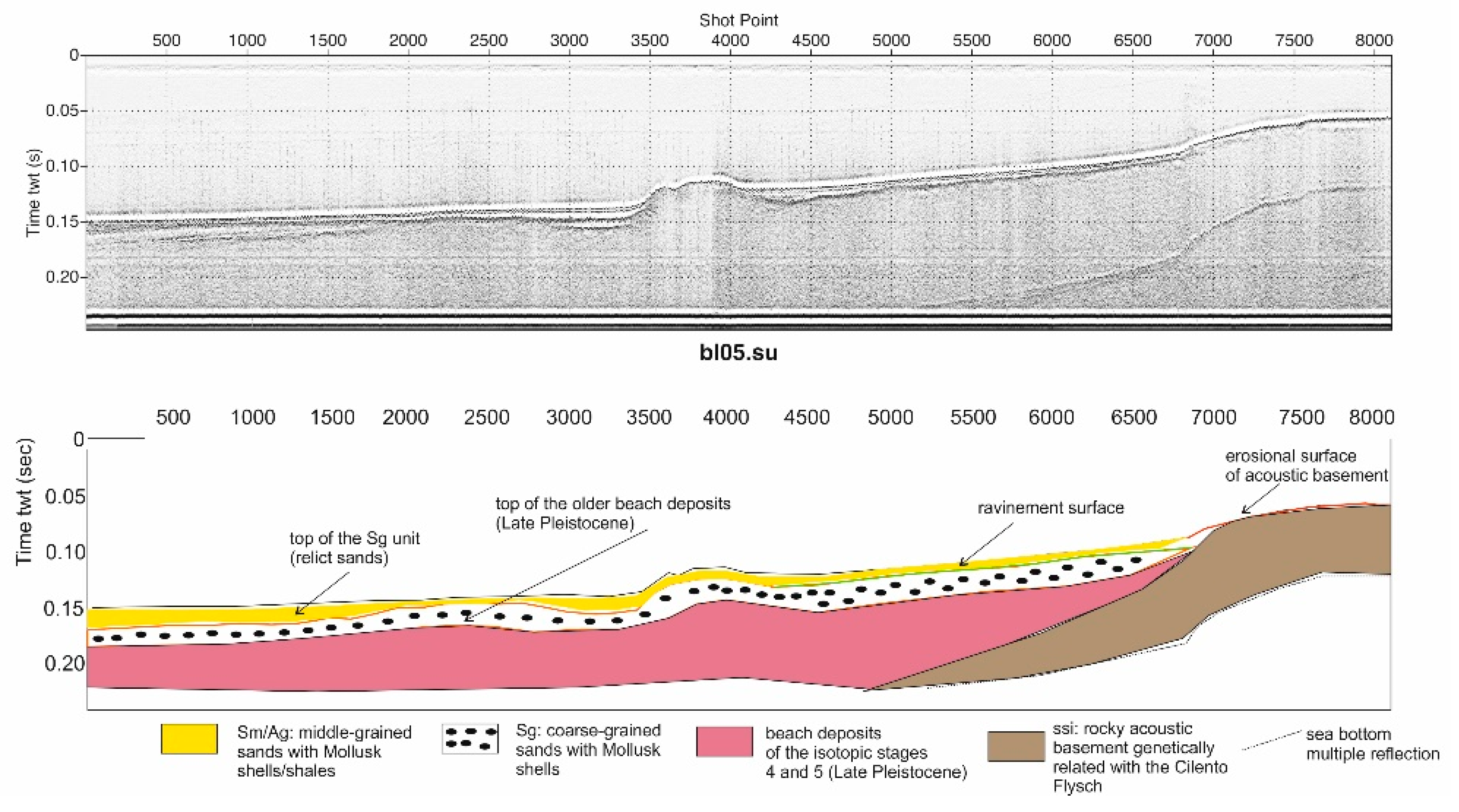
The geological interpretation of the Sub-Bottom profile BL14 is herein described in order to summarize the obtained results [22]. The rocky acoustic basement (ssi unit) was noticed, being coupled with three main seismo-stratigraphic units, as representing the stratigraphic bulk of the Cilento platform. The ssi unit is overlain by a progradational seismic unit interpreted as the beach deposits of the isotopic stages 4 and 3. It exhibits the remnants of old beach systems, which are genetically related with the isotopic stages 4 and 3. The core calibration and the seismo-stratigraphic interpretation showed that this unit is overlain by the Sg unit, which is composed of organogenic sands. Due to its location at water depths higher than the usual ones found in the bioclastic sedimentary model, the Sg unit was interpreted as comprising relict sands. This unit has the shape of sandy ridges (Figure 5), interpreted as a part of the submerged beach, which are genetically related to the last lowstand phase (isotopic stage 2).
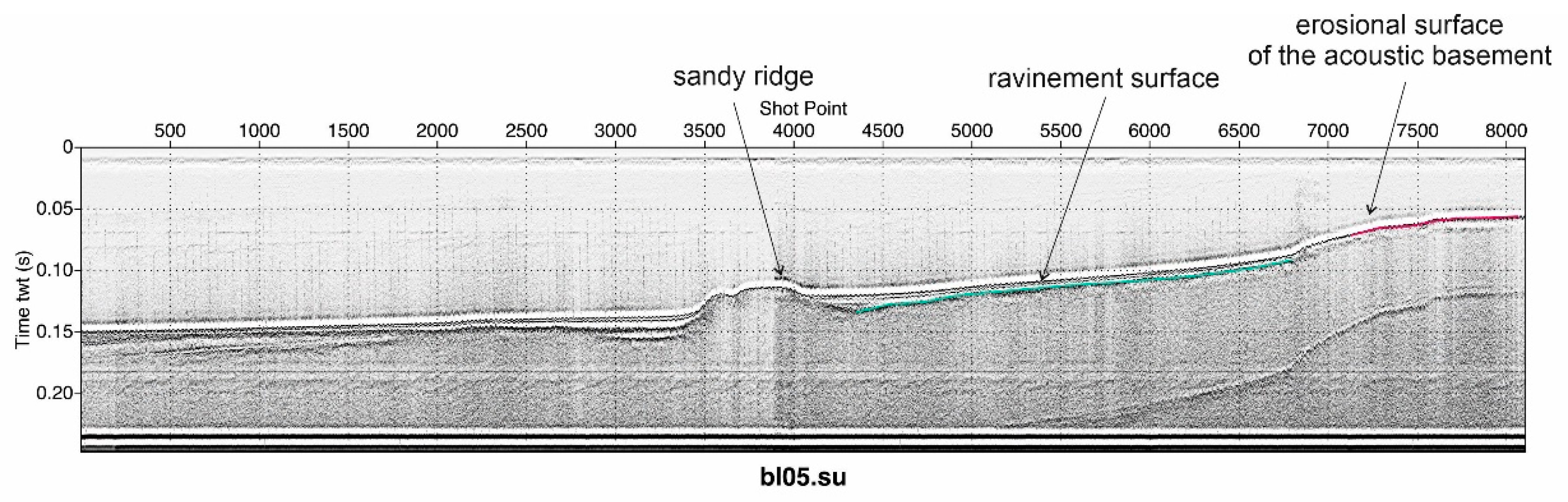
In the Cilento offshore, significant stratigraphic surfaces are represented through the erosional surface of the acoustic basement and the ravinement surface (Figure 4, Figure 5 and Figure 6). The erosional surface of the acoustic basement is a polyciclic erosional surface located at the top of the acoustic basement, which is genetically related with the Cilento Flysch (ssi unit; Figure 4 and Figure 5). The ravinement surface is a time transgressive or diachronous subaqueous erosional surface resulting from nearshore marine and shoreline erosion associated with a sea-level rise [29] (http://www.sepmstrata.org/Terminology.aspx?id=ravinement; accessed on 29 March 2023). This erosional surface parallels the migration of the shoreface across previously deposited coastal deposits. The ravinement surface is commonly ascribed to the transgressive movement of the landward margin of the transgressive systems tract. These erosional surfaces tend to occur wherever the landward edge of the sea rises over an underlying sedimentary surface. Thus, if the late lowstand systems tract has a subaerial landward margin, it will be associated with an up-dip ravinement surface.
The stratigraphic context of the ravinement surface in the study area is herein highlighted. It represents an erosional surface, marking the sudden boundary between the coarse-grained organogenic sands (Sg unit; Figure 5 and Figure 7), which are interpreted as relict deposits, and the overlying fine-grained deposits (Sm-Ag unit; Figure 5 and Figure 7). It develops progressively landward during shoreface retreatment, eroding the acoustic basement, which is genetically related to the Cilento Flysch, and leading to sediment bypass towards offshore (Figure 6).
The geological interpretation of the BL05 Sub-Bottom Chirp profile was carried out. Three main seismo-stratigraphic units occur, overlying the rocky acoustic basement (ssi unit) represented by the Late Pleistocene beach deposits, the remnants of old beach systems, and the Sg and Sm-Ag units, respectively. The obtained results are in overall agreement with the seismo-stratigraphic results summarized through the geological interpretation of the BL14 seismic profile (Figure 5).
5. Discussion
The relict deposits of the Cilento offshore were analyzed based on the seismo-stratigraphic approach. The deposits of relict sands, which are often well preserved, can be ascribed to ancient beaches or coastal environments, which were deposited before or during the last sea-level lowstand (Pleistocene), referring in particular to the lowstand of the last glacial period (18 ky B.P.). Moreover, they are genetically related to the subsequent sea-level rise, during which event these deposits may have been reworked. These deposits fit well within the geological framework of the Quaternary marine deposits of the Cilento offshore, as already described in [22], and belong to the Early Pleistocene period.
A geomorphologic map of the Cilento offshore was constructed in a GIS environment (Figure 4). In this map, the main morphological lineaments were reported, including the sandy ridges composed of relict deposits. The Sg unit forms sandy ridges, located at water depths ranging between 130 and 140 m. These sandy ridges, which are also identified in seismic profiles, were interpreted as a part of the submerged beach (shoreface) and could be related to the last lowstand phase, which corresponds to the isotopic stage 2.
The role of important stratigraphic surfaces (erosional surface of the acoustic basement and ravinement surface) in controlling the stratigraphic architecture of the Cilento offshore was summarized. The first stratigraphic surface is the erosional surface located at the top of the acoustic basement. This surface is characterized by the occurrence of terrace rims, which are summarized based on previous seismo-stratigraphic results. The second stratigraphic surface is the ravinement surface, which represents an erosional truncation involving the upper part of the progradational sequence.
Author Contributions
Conceptualization, G.A.; methodology, M.C.; software, M.C.; formal analysis, G.A.; writing—original draft preparation, G.A.; writing—review and editing, G.A. All authors have read and agreed to the published version of the manuscript.
Funding
This research received no external funding.
Institutional Review Board Statement
Not applicable.
Informed Consent Statement
Not applicable.
Data Availability Statement
Not applicable.
Conflicts of Interest
The authors declare no conflict of interest.
References
- Martelli, L.; Nardi, G.; Cammarosano, A.; Cavuoto, G.; Aiello, G.; D’Argenio, B.; Marsella, E.; Ferraro, L. Note Illustrative della Carta Geologica d’Italia alla Scala 1:50,000; Foglio 502 Agropoli; Regione Campania, ISPRA (Servizio Geologico d’Italia): Rome, Italy, 2016; pp. 1–110. Available online: http://www.isprambiente.gov.it/Media/carg/noteillustrative/502_Agropoli.pdf (accessed on 14 September 2022).
- Emery, K.O. Relict sediments on continental shelf of the world. Am. Ass. Petrol. Geol. Bull. 1968, 52, 445–464. [Google Scholar]
- Albarracin, S.; Alcántara-Carrió, J.; Montoya-Montes, I.; Fontan-Bouzas, A.; Somoza, L.; Amos, C.L.; Rey Salgado, J. Relict sand waves in the continental shelf of the Gulf of Valencia (Western Mediterranean). J. Sea Res. 2014, 93, 33–46. [Google Scholar] [CrossRef]
- Bassetti, M.A.; Jouet, G.; Dufois, F.; Berné, S.; Rabineau, M.; Taviani, M. Sand bodies at the shelf edge in the Gulf of Lions (Western Mediterranean): Deglacial history and modern processes. Mar. Geol. 2006, 234, 93–109. [Google Scholar] [CrossRef]
- Fernández-Salas, L.M.; Rey, J.; Pérez-Vázquez, E.; Ramírez, J.L.; Hernández-Molina, F.J.; Somoza, L.; de Andrés, J.R.; Lobo, F.J. Morphology and characterisation of the relict facies on the internal continental shelf in the Gulf of Cadiz, between Ayamonte and Huelva (southern Iberian Peninsula). Bol. Inst. Esp. Oceanogr. 1999, 15, 123–132. [Google Scholar]
- Pennetta, M.; Bifulco, A.; Savini, A. Ricerca di depositi di sabbia sottomarina relitta sulla piattaforma continentale del Cilento (Sa) utilizzabile per interventi di ripascimento artificiale dei litorali. Geol. Dell’ambiente 2013, 1, 1–21. [Google Scholar]
- Savini, A.; Basso, D.; Bracchi, V.A.; Corselli, C.; Pennetta, M. Maërl-bed mapping and carbonate quantification on submerged terraces offshore the Cilento peninsula (Tyrrhenian Sea, Italy). Geodiversitas 2012, 34, 77–98. [Google Scholar] [CrossRef]
- Sartori, R. Evoluzione neogenico-recente del bacino tirrenico e i suoi rapporti con la geologia delle aree circostanti. G. Geol. 1989, 51, 1–29. [Google Scholar]
- Iannace, A.; Merola, D.; Perrone, V.; Amato, A.; Cinque, A.; Santacroce, R.; Sbrana, A.; Sulpizio, R.; Zanchetta, G.; Budillon, F.; et al. Note Illustrative della Carta Geologica d’Italia alla Scala 1:50,000—Fogli 466–485 Sorrento-Termini; Regione Campania, ISPRA (Servizio Geologico d’Italia): Rome, Italy, 2015; pp. 1–201. Available online: https://www.isprambiente.gov.it/Media/carg/note_illustrative/466_485_Sorrento_Termini.pdf (accessed on 14 September 2022).
- Vitale, S.; Ciarcia, S. Tectono-stratigraphic setting of the Campania region (southern Italy). J. Maps 2018, 14, 9–21. [Google Scholar] [CrossRef]
- Sacchi, M.; Infuso, S.; Marsella, E. Late Pliocene-Early Pleistocene compressional tectonics in offshore Campania (eastern Tyrrhenian sea). Boll. Geof. Teor. Appl. 1994, 36, 469–481. [Google Scholar]
- Aiello, G.; Marsella, E.; Cicchella, A.G.; Di Fiore, V. New insights on morpho-structures and seismic stratigraphy along the Campania continental margin (Southern Italy) based on deep multichannel seismic profiles. Rend. Fis. Acc. Lincei 2011, 22, 349–373. [Google Scholar] [CrossRef]
- Aiello, G.; Cicchella, A.G. Dati sismostratigrafici sul margine continentale della Campania tra Ischia, Capri ed il bacino del Volturno (Tirreno meridionale, Italia) in base al processing sismico ed all’interpretazione geologica di profili sismici a riflessione multicanale. Quad. Geofis. 2019, 149, 1–48. [Google Scholar]
- Conti, A.; Bigi, S.; Cuffaro, M.; Doglioni, C.; Scrocca, D.; Muccini, F.; Cocchi, L.; Ligi, M.; Bortoluzzi, G. Transfer zones in an oblique back-arc basin setting: Insights from the Latium-Campania segmented margin (Tyrrhenian Sea). Tectonics 2017, 36, 78–107. [Google Scholar] [CrossRef]
- Zitellini, N.; Ranero, C.R.; Loreto, M.F.; Ligi, M.; Pastore, M.; D’Oriano, F.; Sallares, V.; Grevemeyer, I.; Moeller, S.; Prada, M. Recent inversion of the Tyrrhenian Basin. Geology 2019, 48, 123–127. [Google Scholar] [CrossRef]
- Bonardi, G.; Amore, F.O.; Ciampo, G.; De Capoa, P.; Miconnet, P.; Perrone, V. Il Complesso Liguride Auct.: Stato delle conoscenze e problemi aperti sull’evoluzione pre-appenninica ed i suoi rapporti con l’Arco Calabro. Mem. Soc. Geol. Ital. 1988, 41, 17–35. [Google Scholar]
- Cammarosano, A.; Cavuoto, G.; Danna, M.; De Capoa, P.; De Rienzo, F.; Di Stasio, A.; Giardino, S.; Martelli, L.; Nardi, G.; Sgrosso, A.; et al. Nuovi dati sul flysch del Cilento (Appennino meridionale, Italia). Boll. Soc. Geol. Ital. 2004, 123, 253–273. [Google Scholar]
- Cammarosano, A.; Cavuoto, G.; Martelli, L.; Nardi, G.; Toccaceli, R.M.; Valente, A. Il Progetto CARG nell’area silentina (area interna Appennino meridionale): Il nuovo assetto stratigrafico-strutturale derivato dal rilevamento dei fogli 503, 502 e 519 (Vallo della Lucania, Agropoli e Capo Palinuro). Rend. Online Soc. Geol. Ital. 2011, 12, 13–18. [Google Scholar]
- Ferraro, L.; Pescatore, T.; Russo, B.; Senatore, M.R.; Vecchione, C.; Coppa, M.G.; Di Tuoro, A. Studi di geologia marina del margine tirrenico: La piattaforma continentale tra Punta Licosa e Capo Palinuro (Tirreno meridionale). Boll. Soc. Geol. Ital. 1997, 116, 473–485. [Google Scholar]
- Aiello, G.; Marsella, E. The contribution of marine geology to the knowledge of marine coastal environment off the Campania region (southern Italy): The geological map n. 502 “Agropoli” (southern Campania). Mar. Geophys. Res. 2013, 34, 89–113. [Google Scholar] [CrossRef]
- Aiello, G. Elaborazione ed interpretazione geologica di sismica di altissima risoluzione nell’offshore del promontorio del Cilento (Tirreno meridionale, Italia). Quad. Geofis. 2019, 155, 1–24. [Google Scholar] [CrossRef]
- Aiello, G.; Caccavale, M. The Depositional Environments in the Cilento Offshore (Southern Tyrrhenian Sea, Italy) Based on Marine Geological Data. J. Mar. Sci. Eng. 2021, 9, 1083. [Google Scholar] [CrossRef]
- Savini, A.; Bracchi, V.A.; Cammarosano, A.; Pennetta, M.; Russo, F. Terraced Landforms Onshore and Offshore the Cilento Promontory (South-Eastern Tyrrhenian Margin) and Their Significance as Quaternary Records of Sea Level Changes. Water 2021, 13, 566. [Google Scholar] [CrossRef]
- Martinson, D.G.; Pisias, N.G.; Hays, J.D.; Imbrie, J.; Moore, T.C.; Shackleton, N.J. Age dating and the orbital theory of the ice ages: Development of a high-resolution 0 to 300,000 year chronostratigraphy. Quat. Res. 1987, 27, 1–29. [Google Scholar] [CrossRef]
- Colorado School of Mines Seismic Unix. 2000. Available online: https://wiki.seismic-unix.org (accessed on 29 March 2023).
- Vail, P.R.; Mitchum, R.M., Jr.; Thompson, S., III. Seismic stratigraphy and global changes of sea level, part IV: Global cycles of relative changes of sea level. In Seismic Stratigraphy—Applications to Hydrocarbon Exploration; Payton, C.E., Ed.; American Association of Petroleum Geologists Memoir: Tulsa, OK, USA, 1977; Volume 26, pp. 83–98. [Google Scholar]
- Mitchum, R.M.; Vail, P.R.; Thompson, S., III. Seismic stratigraphy and global changes of sea level, part 2: The depositional sequence as a basic unit for stratigraphic analysis. In Seismic Stratigraphy—Applications to Hydrocarbon Exploration; Payton, C.E., Ed.; American Association of Petroleum Geologists Memoir: Tulsa, OK, USA, 1977; Volume 26, pp. 53–62. [Google Scholar]
- Catuneanu, O. Principles of Sequence Stratigraphy, 1st ed.; Elsevier: Amsterdam, The Netherlands, 2006; pp. 1–369. [Google Scholar]
- Thorne, J.A.; Swift, D.J.P. Sedimentation on continental margins: VI. A regime model for depositional sequences, their component system tracts, and bounding surfaces. In Shelf Sand and Sandstone Bodies—Geometry, Facies and Sequence Stratigraphy, 1st ed.; Swift, D.J.P., Oertel, G.F., Tillmann, R.W., Thorne, J.A., Eds.; Special Publication; International Association of Sedimentologists, Wiley: New York, NY, USA, 1991; Volume 14, pp. 189–255. [Google Scholar] [CrossRef]
Figure 1.
Geological sketch map of Cilento Promontory.

Figure 2.
Sketch diagram showing depth of terraced surfaces in Licosa Cape structural high based on Sub-bottom Chirp geological interpretation and tentative correlation with curves of isotopic stratigraphy [24].
Figure 2.
Sketch diagram showing depth of terraced surfaces in Licosa Cape structural high based on Sub-bottom Chirp geological interpretation and tentative correlation with curves of isotopic stratigraphy [24].

Figure 3.
Location map of Sub-Bottom Chirp profiles (red lines indicate study’s profiles).

Figure 4.
Geomorphologic map of Cilento offshore, which is constructed in a GIS environment. Location of sandy ridges corresponding with relict deposits was also reported.
Figure 4.
Geomorphologic map of Cilento offshore, which is constructed in a GIS environment. Location of sandy ridges corresponding with relict deposits was also reported.

Figure 5.
Sub-Bottom Chirp profile BL14 and corresponding geological interpretation (modified after Aiello and Caccavale) [22].
Figure 5.
Sub-Bottom Chirp profile BL14 and corresponding geological interpretation (modified after Aiello and Caccavale) [22].

Figure 6.
Stratigraphic surfaces in Cilento offshore, as recognized based on geological interpretation via Sub-Bottom Chirp profile BL05.
Figure 6.
Stratigraphic surfaces in Cilento offshore, as recognized based on geological interpretation via Sub-Bottom Chirp profile BL05.

Figure 7.
Sub-bottom Chirp profile BL05 and corresponding geological interpretation.

Disclaimer/Publisher’s Note: The statements, opinions and data contained in all publications are solely those of the individual author(s) and contributor(s) and not of MDPI and/or the editor(s). MDPI and/or the editor(s) disclaim responsibility for any injury to people or property resulting from any ideas, methods, instructions or products referred to in the content. |
© 2023 by the authors. Licensee MDPI, Basel, Switzerland. This article is an open access article distributed under the terms and conditions of the Creative Commons Attribution (CC BY) license (https://creativecommons.org/licenses/by/4.0/).
Share and Cite
MDPI and ACS Style
Aiello, G.; Caccavale, M. A Seismo-Stratigraphic Analysis of the Relict Deposits of the Cilento Continental Shelf (Southern Italy). Proceedings 2023, 87, 10. https://doi.org/10.3390/IECG2022-14296
AMA Style
Aiello G, Caccavale M. A Seismo-Stratigraphic Analysis of the Relict Deposits of the Cilento Continental Shelf (Southern Italy). Proceedings. 2023; 87(1):10. https://doi.org/10.3390/IECG2022-14296
Chicago/Turabian StyleAiello, Gemma, and Mauro Caccavale. 2023. "A Seismo-Stratigraphic Analysis of the Relict Deposits of the Cilento Continental Shelf (Southern Italy)" Proceedings 87, no. 1: 10. https://doi.org/10.3390/IECG2022-14296