1. Introduction
Coastal cliffs are geological–geomorphological features that form great landscapes, and also have scientific, cultural, and social value all around the world [
1,
2,
3]. Unfortunately, this geomorphological heritage is subject to continuous degradation induced by instabilities that are considered to be the main and most damaging coastal geological hazards [
4]. These instabilities pose risks to people and their property at the base and top of the cliffs, which account for 80% of the world’s ocean shoreline [
5]. More than 1.2 billion people in the world live within 100 km of the coastline, and less than 100 m above the mean sea level [
6].
Landslides are the most predominant risk on a rocky coast. It provides, in some cases, protective deposits accumulated at the base of the cliff, and thus slows down mechanical wave erosion [
7].
Mass movements on steep cliffs are instantaneous phenomena that provide virtually no warning, they are triggered and amplified by a variety of marine and subaerial processes [
8], including waves [
9], groundwater flow [
10], mechanical and chemical weathering [
11], and precipitations [
12]; while cliff lithology [
13], coastal geometry [
14], and structural features [
15] act as conditioning factors. Over the past decade, we have witnessed several accidents caused by cliff collapses and landslides, which have killed or injured people and destroyed several buildings.
A series of modern techniques exist for monitoring coastal cliff evolution [
16], such as terrestrial laser scanning [
17], digital photogrammetry, video monitoring technique [
18], and LiDAR [
19,
20], which provide very detailed data on cliff evolution. However, these monitoring techniques are fairly new and can only provide monitoring results for limited periods of time, at most, on the order of a decade, which is a considerable limitation for monitoring a discontinuous and event-driven process with a low temporal frequency [
21]. Aerial photographs were, until recently, a major source of cliff movement data, and although they are capable of providing much less precise and accurate data than newer techniques, they have the advantage of allowing for a follow-up of long periods of more than half a century, which can provide a more meaningful sampling of larger, but less frequent cliff movements [
22].
At this stage, it is increasingly necessary to improve our knowledge of these areas in order to better manage them, taking into account human safety, but also the preservation of these geological heritages. The rate and modalities of cliff recession are interesting to understand how this specific form of ablation works. Thus, to determine the appropriate protection method, it is essential to master the scientific object before any management action. In this study, our interest is focused on the determination of the recession rate of coastal cliffs in the region of Safi in relation to mass movement types, their distribution, size, and frequency, which depend, in large part, on the type of rocks composing the cliff.
Topographical and Geological Context
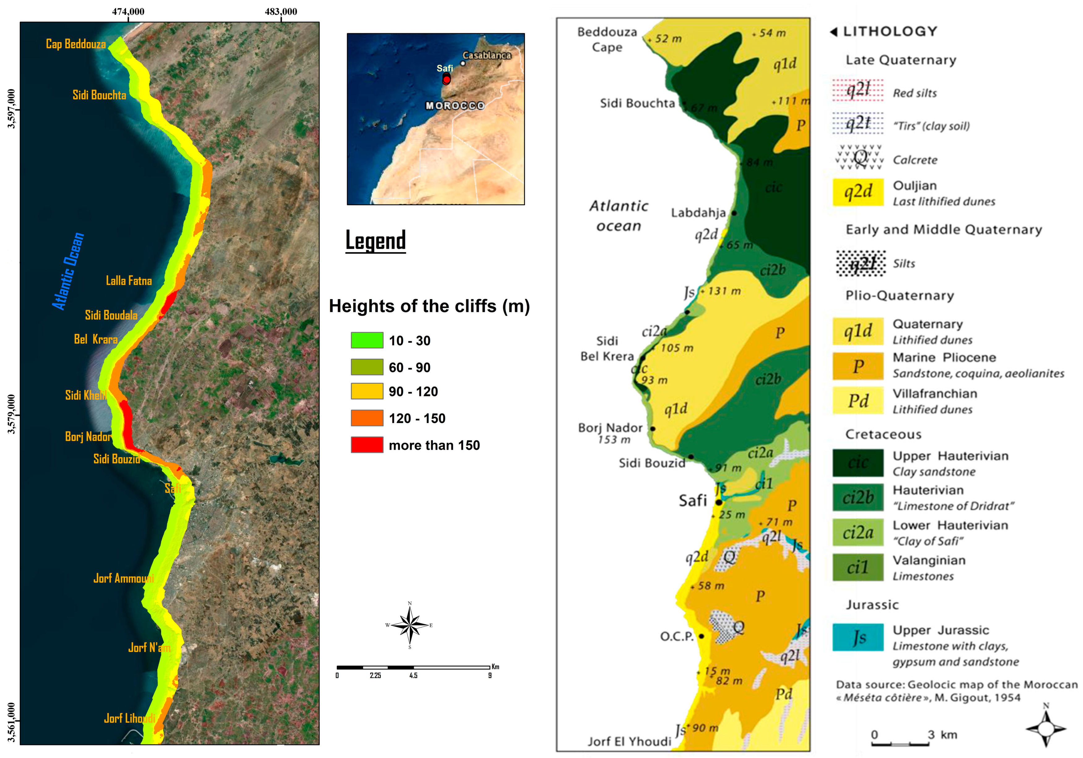
The coastline of the region of Safi is part of the coastal meseta of Morocco. This coastline has a unique character dominated by a cliff morphology. They are real cliffs, which owe their existence to the marine action [
23]. The study area, of which the approximate length is about 48 km long, extends from Cape beddouza (32°40′00″; 09°20′00″) in the north to Jorf lihoudi (32°00′00″; 08°40′00″) in the south. The height of the cliffs can reach more than 150 m in Borj Nador and be reduced to 15 m near the cliff of jorf n’’am, as shown in
Figure 1.
The geological formations of the study area range from the Jurassic to the Quaternary era [
24,
25] and the types of rock present include Plio Quaternary sandstone, clay and sandstone (Hauterivian), limestone of Dridrat (Upper Hauterivian), clays of Safi (Lower Hauterivian), lower limestone (Valanginian) and limestone with clay and gypsum (Upper Jurassic).
2. Materials and Methods
Two methods of analysis were used to carry out this work:
First, a quantitative diachronic approach was taken, of which the objective is to study the evolution of the tops of coastal cliffs from several reference dates in order to define the rate of the recession of these cliffs. The diachronic approach should be based on documents that give the widest possible observation period in order to seek temporal relevance to the phenomenon studied. In the present work, this condition is available based on aerial photographs for the determination of the recession rate of coastal cliffs in the Safi region. The quantitative approach is a classic protocol, including (i) the collection of photographic documents, (ii) the georeferencing and digitization (under the GIS software), and (iii) the calculation of evolution by the DSAS model (digital shoreline analysis system).
Before any diachronic study of a coastline, the question of the choice of the reference line arises, according to the authors [
26]. There are more than a dozen reference lines materializing the position of the coastline [
27]. It must be legible on all documents used. For the cliff coasts, the morphological reference indicator is the foot or the top of the cliff, depending on the authors [
20]. The cliff top is frequently chosen because it is more easily observed in vertical shots. Our interest is focused on determining the recession rate of the top of the coastal cliffs. This choice is dictated by the fact that only the decline of the summit part is important insofar, as this decline affects developments such as buildings, roads, power lines, agriculture, etc. The cliff slopes in the northern part, because the southern part is a rocky cliff, are also undergoing a great deal of change, but these areas are generally not the subject of any development.
The coastline of each series, represented by the top of the cliff, was manually digitized at the selected dates (1954, 1983, and 2020) with a standardized scale, to ensure greater homogeneity. The approach to quantifying the recession of the cliff shores is to compare the position of the top of the cliff, according to a previously established reference line, between two given dates, and to conclude the recession values according to a spatial and temporal relevance. The method known as the digital shoreline analysis system (DSAS) [
28] simplifies the quantification and change trends by several analytical techniques, the most important of which is the end-point rate (EPR), which estimates the rate of erosion or accumulation by dividing the distance of the shoreline movement by the number of years between the two positions (Equation (1)).
Secondly, the geomorphological approach consists of analyzing unstable elements based on the diachronic analysis of the mass movements affecting the cliff (modalities of cliff recession), observable geomorphological markers, previously georeferenced aerial photographs, and field investigations. This approach collected data on the different types of land movements, and mapped their frequency, intensity, and spatial distribution.
3. Results
In this analysis, the term “shoreline” will represent the digitized position of the cliff top (edge of the cliff), and the term will be used a synonym for the DSAS tool. The cliff top was extracted from aerial photographs from 1954, 1983, and 2020, covering a period of 66 years. The rate of the shoreline change was calculated using the DSAS model and two different statistical analyses: end-point rate (EPR) and net shoreline movement (NSM). The baselines were built offshore and parallel to the general shoreline trend with 5 m wide transects.
Rocky cliff shorelines are unique in that they constantly erode and change slowly with time and space. Moreover, the rate of change often varies from zero for stability to less than zero in the case of recession. One of the critical issues for the study area is the retreat rate and the mass movement type of the cliffs, especially for the area between Cap Beddouza in the north and Jorf lihoudi in the south (about 48 km long). To define the recession severity, a qualitative analysis is performed, using the NSM model along the northern and southern sectors (
Figure 2).
The delineation of recession severity and stable transects indicates that the northern and southern areas of Safi experienced a recession for the period 1954–2020, with a visible difference between the north and the south. In addition, the cliff recession rates are quantified spatially and temporally for each sector using the statistical model of the EPR (
Figure 3). The results of this study are compiled in
Table 1 and present the local average recession rates of the top of the cliffs and the percentage of the transects eroded for the two sectors. Nearly 4561 transects out of 5492 in the northern sector and 1608 out of 3078 in the southern sector show erosive characteristics, with an average recession rate of −0.08 m/year for the northern shoreline and −0.04 m/year for the southern one, as shown in
Figure 3 and
Table 1.
Beyond the recession rates, it is also fundamental to understand the spatial distribution and the type of mass movement activity. To do this, the mass movements visible on the ground have been counted and analyzed.
This inventory has the advantage of providing information on the type, size, abundance, activity, and recession rate. A continuous erosion with an abrupt localized recession characterizes the evolution of the Safi coastal cliffs.
The recession occurs over a long period of time, followed by a sudden major event. A total of 280 mass movements of which the traces are still visible have been identified in the field between Cap Beddouza and Jorf Lihoudi.
These recorded events are spatially unevenly distributed from north to south. In this area, the study has allowed us to distinguish roughly four types of dominant mechanisms. The instabilities are related to the dynamics of the rocks from either sliding, toppling or falling.
The inventory of these movements allows us to study their spatial distribution. A predominance of rockfall phenomena along the entire coast (north and south sectors) can be distinguished from other fossil processes, discontinuous and limited. However, the size of the landslides by rotation is very high. On the contrary, overturning and translational landslides extend at most over a few tens to a few hundreds of meters. These mass movements can also be classified in terms of their activity type according to the typology of Varnes in [
29], from the largest to the smallest.
The abandoned dormant type, defined as inactive, is no longer affected by the initial activating causes, as it has reached a certain stability. The forms are fossil, and vegetation is beginning to cover the movement. Rotational landslides are punctually attributed to this state, including the Sidi Khelil landslide (north of Borj Nador), of which the length is 480 m, with a volume of 1.2 million m
3 (
Figure 4).
Dormant episodic movements are related to other types of movements of which the triggering conditions can recur and be easily reactivated such as translational and collapse slides. They are not considered active as no significant movement appears to have occurred in the last ten years. Note that some areas listed as episodically dormant have been subject to rockfall, but in minor proportions, indicating very little instability activity (
Figure 4).
Finally, intermittently active movements, with sporadic events over the last 10 years correspond to block falls. In contrast to dormant movements, active movements are exerted under the simple effect of gravity (
Figure 5).
The different types of mass movements are characterized by different criteria, namely size, abundance, activity over time, and their effect on the shoreline recession. It can be seen that the block falls and collapses are active, especially on the cliff crest, and have a net effect on a top cliff line recession, while large-scale slides affecting the cliff slopes are fossilized and cause top cliff line recession. They also provide accumulated protective deposits at the base of the cliff, and thus slow down mechanical erosion when waves cannot remove all deposits (
Table 2).
4. Discussion
In response to natural processes and anthropogenic actions, rocky cliff shorelines change and evolve over time and space [
30,
31,
32,
33]. Changes in shoreline position by recession and mass movement can be drastic and expensive, as they apparently affect marine human activities [
30]. The results of this study on recession rates and analysis of associated recession patterns show a significant difference from north to south. The northern part is an area marked by large translational and rotational landslides, with an average recession rate of −0.07 m/year, greater than that of the southern sector. The reconciliation between the recession rate and the associated mode shows that areas with a low recession rate are characterized only by rockfall instability, while very high and high recession rates are associated with lands of very large mass movements, such as rotational and translational slides. Of all the observations, the reason for the difference between the dynamics of the northern and southern sectors can be explained by sector-specific criteria that can be summarized by the characteristics of rock lithology and morphological factors, often mentioned in the literature as likely to influence the regressive dynamics of the cliffs. The northern part between Cap Beddouza and the port of Safi, where the cliffs are of complex morphology consisting of cornice, slope and cliff foot, has clay formations as a large part of their profiles. On the other hand, it is the highest part of the coastline (
Figure 1), and according to field observations, it presents complex and diverse dynamics in terms of cliff movements. The southern part, from the town of Safi to Jorf-Lihoudi, has rocky-cliffs of medium height, with quaternary formations composed entirely of limestone rocks and a total absence of clay. These differences are therefore sufficient for the behavior of these coastal cliffs to be different from north to south. Thus, from all the above observations and descriptions, and as a conclusion to this discussion, we can confirm that cliff lithology plays an important role not only in the recession rate, but also the recession mode. Thus, the clay formations with little resistance are conducive to large-scale gravitational movements, such as rotational landslides, and this is particularly visible in the northern part, which has led to a significant regression of the top cliff line, while the southern part, characterized by an outcrop of the plio-quaternary types with a total absence of clay and entirely composed of limestone rocks, gives movements of collapse and rockfall types.
5. Conclusions
Cliff coasts everywhere are characterized by erosion phenomena. The management of cliff coasts along the world’s coasts, which combine high landscape and cultural value with increasing visitor appeal, requires the development of specific characterization strategies to assess their vulnerability to instability, and the implementation of management strategies that ensure safety. Over the last decade and within the study area, we have witnessed several cliff collapses and slides. At this point, it is increasingly necessary to manage these spaces, taking into account the safety of visitors, but also the preservation of these geological heritages. The rate of recession of the high cliffs and the analysis of the modalities of their recession is interesting information for the understanding of the functioning of this specific form of ablation. Thus, to determine the appropriate protection method, it is essential to master the scientific object before any management action. In this context, this article focuses on the problem associated with the evolution of the position of the cliff top along the coast of Safi from Cap Beddouza in the north, to Jorf Lihoudi in the south during the period from 1954 to 2020, and the analysis of the mass movement types associated with this retreat that affects this area of natural and socio-economic importance. During the 66 years, the position of the top of the cliffs has changed significantly, with a clear landward migration from the north to the south, with different mass movements recorded in these sea cliffs of which the lithological and morphological characteristics play major roles in the spatialization of the types of these movements.
Author Contributions
Conceptualization, C.I. and M.C.; methodology, C.I. and F.E.B.; validation, M.A.O., A.C. and M.C.; formal analysis, H.A.M.; investigation, C.I., M.C. and A.C.; resources, M.C.; data curation, C.I.; writing—original draft preparation, C.I.; writing—review and editing, M.A.O., F.E.B., M.C., H.A.M., and A.C.; visualization, F.E.B.; supervision, M.C.; project administration, A.C.; funding acquisition, M.C. All authors have read and agreed to the published version of the manuscript.
Funding
This work is part of the project “littoral of the Marrakech-Safi region: Elements of integrated management and sustainable development (case of the Safi coastline)”, which was supported by the program Ibn Khaldoun (Grant number IK/2018/16) that was funded by the CNRST (National Center for Scientific and Technical Research), Morocco.
Institutional Review Board Statement
Not applicable.
Informed Consent Statement
Not applicable.
Data Availability Statement
The data that support the findings of this study are available from the corresponding author, [C.I.], upon reasonable request.
Conflicts of Interest
The authors declare no conflict of interest.
References
- Emery, K.O.; Kuhn, G.G. Sea Cliffs: Their Processes, Profiles, and Classification. Geol. Soc. Am. Bull. 1982, 93, 644–654. [Google Scholar] [CrossRef]
- Panizza, M. Geomorphosites: Concepts, Methods and Examples of Geomorphological Survey. Chin. Sci. Bull. 2001, 46, 4–5. [Google Scholar] [CrossRef]
- Kubalíková, L. Geomorphosite Assessment for Geotourism Purposes. Czech J. Tour. 2013, 2, 80–104. [Google Scholar] [CrossRef]
- Luijendijk, A.; Hagenaars, G.; Ranasinghe, R.; Baart, F.; Donchyts, G.; Aarninkhof, S. The State of the World’s Beaches. Sci. Rep. 2018, 8, 6641. [Google Scholar] [CrossRef]
- Letortu, P.; Costa, S.; Maquaire, O.; Delacourt, C.; Augereau, E.; Davidson, R.; Suanez, S. Taux d’ablation Des Falaises Crayeuses Haut-Normandes: L’apport Du Scanner Laser Terrestre. Geomorphologie 2015, 21, 73–82. [Google Scholar] [CrossRef]
- Marone, E.; de Camargo, R.; Salcedo Castro, J. Coastal Hazards, Risks, and Marine Extreme Events: What Are We Doing about It? In Oxford Handbook Topics in Physical Sciences; Oxford Handbooks Editorial Board, Ed.; Oxford University Press: Oxford, UK, 2017; ISBN 978-0-19-069942-0. [Google Scholar]
- Ayt Ougougdal, M.; Chaibi, M.; Mercier, D.; Maquaire, O.; Maanan, M.; Costa, S.; Charif, A.; Ragaru, E. The Typology of Slope Slides of the Cliff Coast of Safi-Morocco, and the Role of the Clay Layer in Triggering Failure. J. Afr. Earth Sci. 2020, 168, 103878. [Google Scholar] [CrossRef]
- Alessio, P.; Keller, E.A. Short-Term Patterns and Processes of Coastal Cliff Erosion in Santa Barbara, California. Geomorphology 2020, 353, 106994. [Google Scholar] [CrossRef]
- Young, A.P.; Guza, R.T.; O’Reilly, W.C.; Gutierrez, R. Short-Term Retreat Statistics of a Slowly Eroding Coastal Cliff. Nat. Hazards Earth Syst. Sci. 2011, 11, 205–217. [Google Scholar] [CrossRef]
- Pierre, G.; Lahousse, P. The Role of Groundwater in Cliff Instability: An Example at Cape Blanc-Nez (Pas-de-Calais, France). Earth Surf. Process. Landf. 2006, 31, 31–45. [Google Scholar] [CrossRef]
- Porter, N.J.; Trenhaile, A.S. Short-Term Rock Surface Expansion and Contraction in the Intertidal Zone. Earth Surf. Process. Landf. 2007, 32, 1379–1397. [Google Scholar] [CrossRef]
- Collins, B.D.; Sitar, N. Processes of Coastal Bluff Erosion in Weakly Lithified Sands, Pacifica, California, USA. Geomorphology 2008, 97, 483–501. [Google Scholar] [CrossRef]
- Sunamura, T. Geomorphology of Rocky Coasts; John Wiley and Sons: Hoboken, NJ, USA, 1992. [Google Scholar]
- Hampton, M.A.; Griggs, G.B. Formation, Evolution, and Stability of Coastal Cliffs–Status and Trends; Professional Paper 1693; U.S. Geological Survey: Denver, CO, USA, 2004; pp. 7–38.
- Duperret, A.; Genter, A.; Martinez, A.; Mortimore, R.N. Coastal Chalk Cliff Instability in NW France: Role of Lithology, Fracture Pattern and Rainfall. EGSP 2004, 20, 33–55. [Google Scholar] [CrossRef]
- Medjkane, M.; Maquaire, O.; Costa, S.; Roulland, T.; Letortu, P.; Fauchard, C.; Antoine, R.; Davidson, R. High-Resolution Monitoring of Complex Coastal Morphology Changes: Cross-Efficiency of SfM and TLS-Based Survey (Vaches-Noires Cliffs, Normandy, France). Landslides 2018, 15, 1097–1108. [Google Scholar] [CrossRef]
- Dewez, T.J.B.; Rohmer, J.; Regard, V.; Cnudde, C. Probabilistic Coastal Cliff Collapse Hazard from Repeated Terrestrial Laser Surveys: Case Study from Mesnil Val (Normandy, Northern France). J. Coast. Res. 2013, 65, 702–707. [Google Scholar] [CrossRef]
- Valentini, N.; Saponieri, A.; Damiani, L. A New Video Monitoring System in Support of Coastal Zone Management at Apulia Region, Italy. Ocean. Coast. Manag. 2017, 142, 122–135. [Google Scholar] [CrossRef]
- Terefenko, P.; Paprotny, D.; Giza, A.; Morales-Nápoles, O.; Kubicki, A.; Walczakiewicz, S. Monitoring Cliff Erosion with LiDAR Surveys and Bayesian Network-Based Data Analysis. Remote Sens. 2019, 11, 843. [Google Scholar] [CrossRef]
- Young, A.P.; Flick, R.E.; Gutierrez, R.; Guza, R.T. Comparison of Short-Term Seacliff Retreat Measurement Methods in Del Mar, California. Geomorphology 2009, 112, 318–323. [Google Scholar] [CrossRef]
- Marques, F. Regional Scale Sea Cliff Hazard Assessment at Sintra and Cascais Counties, Western Coast of Portugal. Geosciences 2018, 8, 80. [Google Scholar] [CrossRef]
- Barlow, J.; Lim, M.; Rosser, N.; Petley, D.; Brain, M.; Norman, E.; Geer, M. Modeling Cliff Erosion Using Negative Power Law Scaling of Rockfalls. Geomorphology 2012, 139–140, 416–424. [Google Scholar] [CrossRef]
- Weisrock, A. Les falaises de la côte atlantique marocaine de Safi à Bedouzza (Cap Cantin). (The cliffs of the at/antic moroccan coast between Safi and Bedouzza.). Bagf 1985, 62, 93–104. [Google Scholar] [CrossRef]
- Gigout, M. Etudes Géologiques Sur La Méséta Marocaine Occidentale (Arrière-Pays de Casablanca, Mazagan et Safi); Imprimerie Maroc-Matin: Rabat, Morocco, 1951; Volume 86. [Google Scholar]
- Witam, O. Étude Stratigraphique et Sédimentologique de La Série Mésozoïque Du Bassin de Safi; Thèse de 3 ème cycle; Université Cadi Ayyad de Marrakech: Marrakech, Morocco, 1988. [Google Scholar]
- Boak, E.H.; Turner, I.L. Shoreline Definition and Detection: A Review. J. Coast. Res. 2005, 214, 688–703. [Google Scholar] [CrossRef]
- Faye, I.B.N.; Hénaff, A.; Gourmelon, F.; Diaw, A.T. Évolution Du Trait de Côte à Nouakchott (Mauritanie) de 1954 à 2005 Par Photo-Interprétation. Norois 2008, 208, 11–27. [Google Scholar] [CrossRef]
- Jonah, F.E.; Mensah, E.A.; Edziyie, R.E.; Agbo, N.W.; Adjei-Boateng, D. Coastal Erosion in Ghana: Causes, Policies, and Management. Coast. Manag. 2016, 44, 116–130. [Google Scholar] [CrossRef]
- Dikau, R.; Brunsden, D.; Schrott, L.; Ibsen, L. Landslide Recognition: Identification, Movement and Causes; Wiley & Sons: Hoboken, NJ, USA, 1996. [Google Scholar]
- Defeo, O.; McLachlan, A.; Schoeman, D.S.; Schlacher, T.A.; Dugan, J.; Jones, A.; Lastra, M.; Scapini, F. Threats to Sandy Beach Ecosystems: A Review. Estuar. Coast. Shelf Sci. 2009, 81, 1–12. [Google Scholar] [CrossRef]
- Moussaid, J.; Fora, A.A.; Zourarah, B.; Maanan, M.; Maanan, M. Using Automatic Computation to Analyze the Rate of Shoreline Change on the Kenitra Coast, Morocco. Ocean Eng. 2015, 102, 71–77. [Google Scholar] [CrossRef]
- Maiti, S.; Bhattacharya, A.K. Shoreline Change Analysis and Its Application to Prediction: A Remote Sensing and Statistics Based Approach. Mar. Geol. 2009, 257, 11–23. [Google Scholar] [CrossRef]
- Natesan, U.; Parthasarathy, A.; Vishnunath, R.; Kumar, G.E.J.; Ferrer, V.A. Monitoring Longterm Shoreline Changes along Tamil Nadu, India Using Geospatial Techniques. Aquat. Procedia 2015, 4, 325–332. [Google Scholar] [CrossRef]
| Disclaimer/Publisher’s Note: The statements, opinions and data contained in all publications are solely those of the individual author(s) and contributor(s) and not of MDPI and/or the editor(s). MDPI and/or the editor(s) disclaim responsibility for any injury to people or property resulting from any ideas, methods, instructions or products referred to in the content. |
© 2023 by the authors. Licensee MDPI, Basel, Switzerland. This article is an open access article distributed under the terms and conditions of the Creative Commons Attribution (CC BY) license (https://creativecommons.org/licenses/by/4.0/).


 ,
, 


