
Geodiversity and Its Implication for Geoconservation of the Youngest Eruptive Sites of Western Samoa †


1
School of Agriculture and Environment, Massey University, Palmerston North 4442, New Zealand
2
Lithosphere Physics Research Group, Institute of Earth Physics and Space Science, 9400 Sopron, Hungary
3
The Geoconservation Trust Aotearoa Pacific, Opotiki 3122, New Zealand
4
Saudi Geological Survey, Jeddah 23632, Saudi Arabia
5
Istituto Nazionale di Geofisica e Vulcanologia, 40128 Bologna, Italy
†
Presented at the 4th International Electronic Conference on Geosciences, 1–15 December 2022; Available online: https://sciforum.net/event/IECG2022 .
Proceedings 2023, 87(1), 33; https://doi.org/10.3390/IECG2022-13751
Published: 30 November 2022
(This article belongs to the Proceedings of The 4th International Electronic Conference on Geosciences)
Abstract
:The last volcanic eruption in Western Samoa, which occurred between 1905 and 1911, produced a complex scoria and lava spatter cone and an extensive lava field that destroyed Sale’aula village, near the Pacific coast. This eruption, referred to as the Matavanu eruption, also produced pahoehoe-type lava flows with superbly preserved surface textures, tumuli, and some littoral explosion craters in its distal lava field. The unique nature of the location meant that it was selected as one of the first of the 100 IUGS Geological Heritage Sites, in October 2022. The region has been under an investigation that aims to document the geoheritage elements of the location, estimate its geodiversity, and explore the potential to develop a geopark together with local communities. All this work intends to provide a firm knowledge base to identify effective geoconservation strategies. While the youngest eruptive products after over 100 years of revegetation are restricted to a coastal zone, previous research has demonstrated that other young volcanic eruptions also took place in northern Savai’i in 1760 and 1902. In this study, we provide further data based on a systematic evaluation of SENTINEL satellite imagery, in combination with an ALOS-PALSAR and SRTM 30-m resolution digital terrain model-based calculation of morphometric elements, to demonstrate that the young volcanic landscape in northern Savai’i has great volcanic geodiversity and the entire region should be considered for specific geoconservation strategies. The young volcanic landforms of scoria cones in the high-altitude regions of the island, along with extensive and commonly tube-fed lava flows which have invaded the northern region of Savai’i, pose a volcanic hazard to the region. Hence, volcanic geoheritage can be the core element to enforce strong community volcanic hazard resilience. The newly proposed Samoa Geopark Project is the perfect avenue to achieve this.
1. Introduction
Western Samoa is in the SW Pacific and contains two large volcanic islands along with some small offshore islets, each volcanic in origin [1,2,3]. The two main islands, Upolu and Savai’i are typical ocean islands with extensive volcanic lava shields topped by hundreds of small-volume post-shield volcanic cones, mostly with Strombolian-style scoria (cinder) cones and associated lava spatter mounds and lava flows [3]. Both islands, which lie beside the recent Quaternary fluvial and beach sediments, are volcanic in origin [3]. The oldest volcanic rocks crop out in Upolu. The general understanding of the volcanic eruption argues that the youngest volcanism, which occurred exclusively in Savai’i, can be interpreted as a westward migration of volcanism in the last millions of years [3,4,5,6,7]. While this trend is generally feasible, there is evidence for young, Pleistocene volcanism along the dorsal ridge of Upolu without apparent spatial trends [1,8].
Young, extensive lava field-producing volcanic eruptions took place in the Holocene in the northern sector of Savai’i in scoria cone vents located in the main ridges, at least ~700 m above sea level. The youngest eruption took place in the NE edge of Savai’i, commonly referred to as the Matavanu eruption, and lasted for approximately 6 years, between 1905 and 1911 [9]. The eruption emitted large volumes of mostly pahoehoe-type ocean island basalts and inundated the region, producing an unconfined lava field in the coastal areas and enlarging the island itself. Partial erosion of the lava fields over the last approximately 100 years has provided volcaniclastic sediments which have built a basaltic sand spit and formed a lagune just adjacent to the terminus to the lava flows. This region is currently under investigation in order to determine the geoheritage values and geodiversity of the sites and thus identify various geosites as part of the Samoa Geopark Project, which is currently part of a government-level initiative [10,11]. This increased activity on geoheritage studies culminated in the Matavanu Eruption Site being listed among the first of the 100 IUGS Geological Heritage Sites [https://iugs-geoheritage.org/videos-pdfs/iugs_first_100_book_v2.pdf—accessed on 24 November 2022]. In this study, we provide further evidence to justify this location as a globally significant geological heritage site by using various morphological, satellite, and direct observational data. In addition, a lava flow inundation model is presented here for the first time, to highlight the volcanic hazard of the region and its potential role in geoeducation for developing a resilience in society against natural hazards.
2. Materials and Methods
2.1. Study Area
The study area is part of the NE sector of Savai’i Island (Figure 1). Savai’i is a volcanic island reaching 1858 m above sea level (Mount Silisili) within 20-km from its coastlines. The island has a low slope in every direction with an exception toward the north where a large, scalloped shape escarpment is clearly visible (Figure 1).
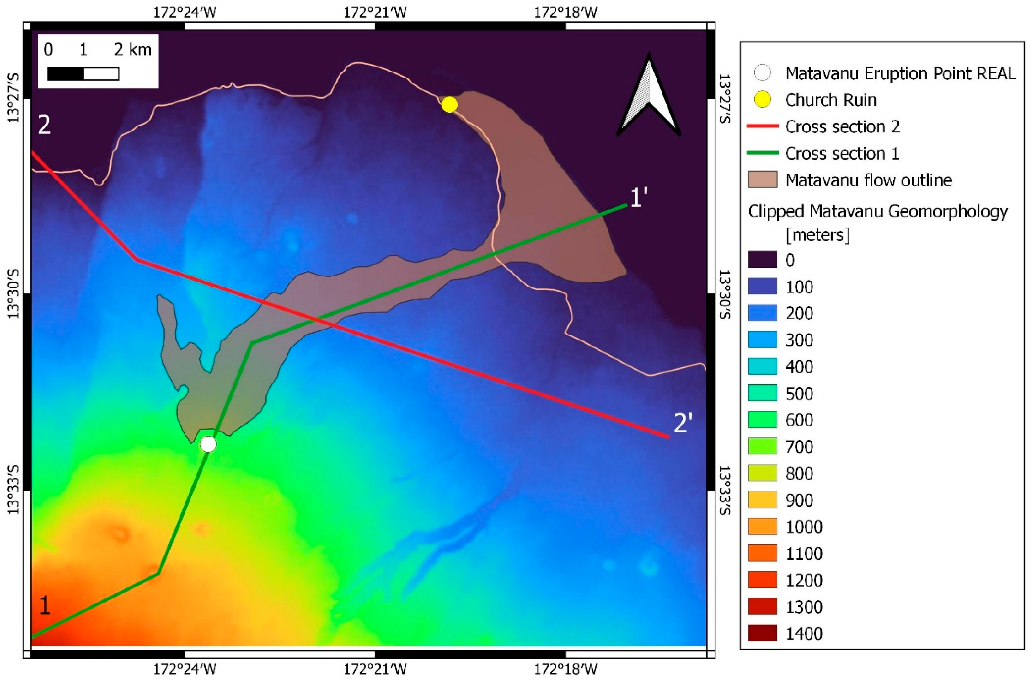
The origin of this feature is debated in the literature, but a potential former volcano-collapse is commonly argued as being the main cause, despite the fact that there is no surface manifestation of any volcanic debris avalanches in the present-day island landmass or in the sporadic sea floor data [12]. The 1905–1911 lava flow field was initiated from a vent located 650 m above sea level in addition to a suspected second cone located about 900–1000 m above sea level (Figure 2). Geological mapping has shown that the young lava flow followed a relatively narrow band prior to entering the coastal lowlands, where it expanded, leading to a pond, and inflated and deflated the low viscosity lava.
2.2. Satellite Imagery, Basic Terrain Analysis, Field Observations, and Lava Flow Modelling
In this work, we utilized freely available data sets such as Sentinel Hub (https://apps.sentinel-hub.com/eo-browser/, accessed on 10 October 2022), NASA Shuttle Radar Topography Mission (SRTM) 30-m DEM (https://www.earthdata.nasa.gov, accessed on 10 October 2022), and ALOS-PALSAR 12.5-m DEM (https://search.asf.alaska.edu, accessed on 10 October 2022). For lava flow inundation modelling, the Q-LavHA freeware was used (https://we.vub.ac.be/en/q-lavha, accessed on 17 March 2022).
We selected the True Colour Composite from the Sentinel-2 database, which created true colour images based on the visible light bands of red, green, and blue. In this image, the natural vegetation coverage over lava fields is clearly shown. In addition, the Geology 8, 11, 12 composite image was used to identify fresh basaltic rock surfaces based on the short-wave infrared (SWIR) bands 11 and 12. Near Infrared (NIR) band 8, in the same composite image, highlights vegetation which yields useful information about the status of vegetation coverage over young lava flows.
For basic terrain analysis within the Q-GIS software environment (https://qgis.org, accessed on 26 February 2022), SRTM and ALOS-PALSAR elevation data were used to generate a slope angle map to see the morphological variety of the study area. In order to see the region morphological variation, a geomorphon [13] map was created.
For the lava flow modelling, the Q-LavHA software was employed. Although this lava flow simulation technique was primarily developed for lava flows that are channel fed [14,15,16], instead of sensu stricto pāhoehoe tube-fed systems, we applied this simulation method because the upper flow regime of the 1905–1911 lavas shows some surface propagation features. In addition, lava tubes are likely to develop in the ponded sector of the flow fields where the steep slope of the (Figure 3) island quickly becomes flat. The simulation followed the prescribed GIS techniques and ran as a plug-in within the Q-GIS software environment.
3. Results
The lava flows of the 1905–1911 eruption event are classified as typical pāhoehoe flows, especially in those areas where ponding in the flat coastal regions is evident. In this region, thin free-flowing flows invaded the London Missionary Society (LMS) Church at Sale’aula (Figure 4a). Typical basaltic, ropy surface textures are well-preserved (Figure 4b) in some places, exposing thick crust along inflated-deflated lava flow regions (Figure 4c). The relatively thin flow lobes are clearly visible outside the invaded LMS Church (Figure 4d). In distal areas, near the present-day coast-line, fresh lava flow fields with smooth surfaced lava regions indicate long-lasting inflation processes and substantial times for smooth, thick crusts to develop over the ponding flows (Figure 4e).
The Sentinel satellite imagery shows a distinct vegetated upper flow region and a barren lower flow field (Figure 5a). This vegetation coverage certainly hinders the mapping of the true extent of the lava flow fields in the upper-middle flow fields (Figure 5a). While existing geological maps clearly show a relatively narrow band of the main flow field in the upper-middle flow facies, site visits revealed that young lavas likely have more extensive coverage in this region and have likely formed lava lobes that cover the northern sector of the study area. Along the upper flow region, just north of the source vent, current topography indicates that lava flow might have flowed quickly on the steep slopes, leaving behind thick flows. Such a pattern can also be seen in the Sentinel-2 Geology 8, 11, 12 composite images, where the fresh flow regions are distinctly darker than the older, vegetated ones (Figure 5b).
For the basic terrain analysis, a slope angle map was created. The slopes of the study area clearly show that the island has a steady slope that reaches about 1000-m above sea level within 15 km distance from the coastline (Figure 5c). The slopes show a slight change about 200-m above sea level in the region where thick pāhoehoe lava flows are noted (Figure 5c). For the geomorphon analysis, the region shows a uniform trend in the dominant portion of the area classified as “slopes-6”. This indicates that the dominant landform element “rules” a morphodiversity of the study area.
4. Discussion
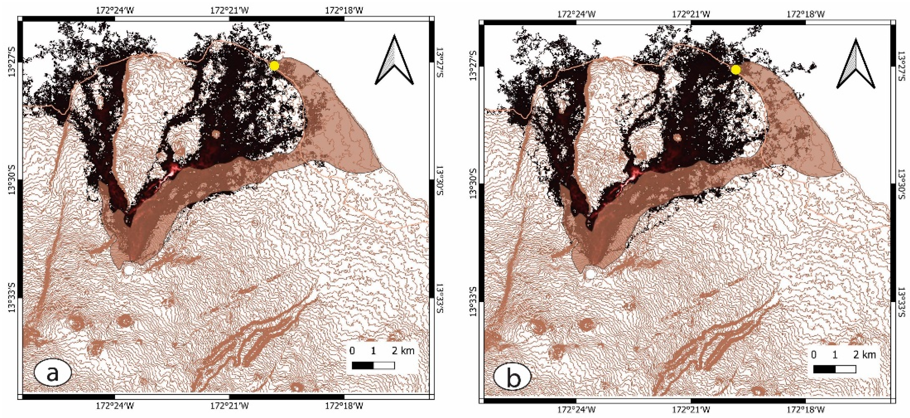
The Matavanu Eruption Site is the youngest and best-preserved volcanic site in Western Samoa where the original volcanic geoforms are clearly recognizable. In this respect, this location can play an exceptional role in geoeducation to disseminate knowledge on the types of volcanic eruptions that Western Samoa could experience. To check the lava flow inundation, Q-LavHA software was employed. To generate a more realistic picture, the DEM region where lava flow was mapped (e.g., shown on available geological maps) was modified manually to run the simulation on a pre-lava flow surface. As the region slope was reasonable high (Figure 5c), the simulation used actual flow length distances (13-km) (Figure 6a) and a measure of longer distances of 130-km (Figure 6b). The two models provided very similar lava flow inundation patterns that were slightly offset from the data currently available on published geological maps [3] (Figure 6a,b). The most dramatic aspect of this simulation was notion that the 1905–1911 lava flows, even if they are thin, might be filling the regions currently vegetated north of the mapped flow fields. Although there is known lava from those regions, its origin in connection with the 1905–1911 flow event has not been considered. Similarly, while the geological maps show a northward trending lava flow, they associate only the near-vent regions as being sourced from the 1905–1911 event. However, the simulation indicates that lava known from these regions might have leaped over the escarpment and potentially could have inundated the western side of the study area. These findings clearly suggest the need to conduct future geological mapping in the region on a scale of 1 to 5000, or larger, to be able to understand the flow inundation of the region. Both simulations, however, need to consider that lava tubes likely formed where the lava flow entered the gentle sloping coastal regions and, consequently, that lava could have been transported successfully in regions where the Q-LavHA simulation (which operates best for channel-fed surface flows) could not have provided satisfying results.
In this research, we concluded that for the study area, which has been listed as one of the first of the 100 IUGS Geological Heritage Sites, a geodiversity estimation needs to be carefully considered. In previous studies, when a 2.5 km-sized grid-based geodiversity estimate was performed, the study area received relatively low scores, probably as a result of the overall monotonous slope (and other derived terrain parameters) as well as the simple geology (e.g., basaltic rocks only) of the region [17]. This problem was addressed further in another study where the “grid” approach was changed to a “real” distribution of mapped geological features as well as a refinement of the geological model of the region specifically designed to capture volcanic geoheritage elements [18]. In this work, a new angle for the scale problem of geodiversity estimates is presented. In order to identify the geoheritage value of a specific location, its geodiversity requires internally defined parameters that are scaled to the location. This is especially true in areas like the 1905–1911 Matavanu Eruption site, where the young volcanism itself determines the geoheritage value of the location.
5. Conclusions
In this work, we explored the geoheritage and geodiversity elements of an iconic site representing the youngest volcanic eruption site in Western Samoa. The combined satellite and geomorphological data investigation revealed that the extent of the young lava flows is likely greater than currently expected. Furthermore, the Q-LavHA lava inundation simulation indicated that the young lava flow field is likely more extensive than the current geological maps indicate. While the terrain analysis indicated that the region has monotonous topographical features, “pushing” morphodiversity to a relatively low value, the geological diversity estimates need further revision, such as assigning higher values to those regions where original volcanic geoforms in various scales (from micro, hand-specimen to outcrop and landscape element scales) are preserved.
Funding
This research received no external funding.
Institutional Review Board Statement
Not applicable.
Informed Consent Statement
Not applicable.
Data Availability Statement
Not applicable.
Acknowledgments
Fruitful discussions about geodiversity estimates, lava flow simulations, and the geoconservation of volcanic regions with Vlad Zakharovsky, Ilmars Gravis, and Chris Twemlow are greatly appreciated.
Conflicts of Interest
The author declares no conflict of interest.
References
- Németh, K.; Cronin, S.J. Volcanic structures and oral traditions of volcanism of Western Samoa (SW Pacific) and their implications for hazard education. J. Volcanol. Geotherm. Res. 2009, 186, 223–237. [Google Scholar] [CrossRef]
- Kear, D. Geological notes on western Samoa. N. Z. J. Geol. Geophys. 1967, 10, 1446–1451. [Google Scholar] [CrossRef]
- Keating, B.H. Geology of the Samoan Islands. In Geology and Offshore Mineral Resources of the Central Pacific Basin; Keating, B.H., Bolton, B.R., Eds.; Circum-Pacific Council for Energy and Mineral Resources, Earth Science Series; Circum-Pacific Council for Energy and Mineral Resources: Houston, TX, USA, 1991; Volume 14, pp. 127–178. [Google Scholar]
- Konter, J.G.; Jackson, M.G. Large volumes of rejuvenated volcanism in Samoa: Evidence supporting a tectonic influence on late-stage volcanism. Geochem. Geophys. Geosyst. 2012, 13, Q07025. [Google Scholar] [CrossRef]
- Koppers, A.A.P.; Russell, J.A.; Roberts, J.; Jackson, M.G.; Konter, J.G.; Wright, D.J.; Staudigel, H.; Hart, S.R. Age systematics of two young en echelon Samoan volcanic trails. Geochem. Geophys. Geosyst. 2011, 12, Q07025. [Google Scholar] [CrossRef]
- McDougall, I. Age of volcanism and its migration in the Samoa Islands. Geol. Mag. 2010, 147, 705–717. [Google Scholar] [CrossRef]
- Jackson, M.G.; Hart, S.R.; Konter, J.G.; Koppers, A.A.P.; Staudigel, H.; Kurz, M.D.; Blusztajn, J.; Sinton, J.M. Samoan hot spot track on a “hot spot highway”: Implications for mantle plumes and a deep Samoan mantle source. Geochem. Geophys. Geosyst. 2010, 11, Q12009. [Google Scholar] [CrossRef]
- Gale, S.J.; Miggins, D.P.; Fepuleai, A. Ar-40/Ar-39 dating of Quaternary volcanic rocks in Samoa. N. Z. J. Geol. Geophys. 2021, 65, 381–388. [Google Scholar] [CrossRef]
- Anderson, T. The Volcano of Matavanu in Savaii. Q. J. Geol. Soc. 1910, 66, 621–639. [Google Scholar] [CrossRef]
- Fepuleai, A.; Németh, K.; Muliaina, T. Geopark impact for the resilience of communities in Samoa, SW Pacific. Geoheritage 2021, 13, 50. [Google Scholar] [CrossRef]
- Németh, K.; Fepuleai, A.; Muliaina, T. Samoa Geopark Project: A strategic plan to promote the volcanic geoheritage of Savai’i Island, Samoa. In Proceedings of the STAR 2017—The Pacific Islands Science, Technology and Resources Conference, Nadi, Fiji, 26–29 June 2017. [Google Scholar] [CrossRef]
- Cronin, S.J.; Bonte-Grapentin, M.; Németh, K. Samoa technical report—Review of volcanic hazard maps for Savai’i and Upolu. EU-SOPAC Proj. Rep. 2006, 59, 1–27. [Google Scholar]
- Jasiewicz, J.; Stepinski, T.F. Geomorphons—A pattern recognition approach to classification and mapping of landforms. Geomorphology 2013, 182, 147–156. [Google Scholar] [CrossRef]
- Mossoux, S.; Saey, M.; Bartolini, S.; Poppe, S.; Canters, F.; Kervyn, M. Q-LAVHA: A flexible GIS plugin to simulate lava flows. Comput. Geosci. 2016, 97, 98–109. [Google Scholar] [CrossRef]
- Prieto-Torrell, C.; Rodriguez-Gonzalez, A.; Aulinas, M.; Fernandez-Turiel, J.L.; Cabrera, M.C.; Criado, C.; Perez-Torrado, F.J. Modelling and simulation of a lava flow affecting a shore platform: A case study of Montana de Aguarijo eruption, El Hierro (Canary Islands, Spain). J. Maps 2021, 17, 502–511. [Google Scholar] [CrossRef]
- Vilches, M.; Ureta, G.; Grosse, P.; Nemeth, K.; Aguilera, F.; Aguilera, M. Effusion rate estimation based on solidified lava flows: Implications for volcanic hazard assessment in the Negros de Aras monogenetic volcanic field, northern Chile. J. Volcanol. Geotherm. Res. 2022, 422, 107454. [Google Scholar] [CrossRef]
- Zakharovskyi, V.; Németh, K. Qualitative-Quantitative Assessment of Geodiversity of Western Samoa (SW Pacific) to Identify Places of Interest for Further Geoconservation, Geoeducation, and Geotourism Development. Geographies 2021, 1, 362–380. [Google Scholar] [CrossRef]
- Zakharovskyi, V.; Németh, K. Scale Influence on Qualitative-Quantitative Geodiversity Assessments for the Geosite Recognition of Western Samoa. Geographies 2022, 2, 476–490. [Google Scholar] [CrossRef]
Figure 1.
Location of the Savai’i Island, represented by a hillshade model generated from SRTM 30-m resolution Digital Elevation Model (DEM) overlain with 20-m interval contour lines. Main sealed road shown from ESRI Transportation layers while the outline of the lava flow field of the 1905–1911 Matavanu Eruption is shown with a brown field along with its source vent (white dot). One of the largest lava tubes of Samoa (Lauoleola), marked by a yellow dot that is located in the middle lava flow field, erupted in 1760 AD, sourced from vents (Mauga Afi) in the dorsal ridge.

Figure 2.
The location of the 1905–1911 Matavanu Eruption Site on an SRTM 30-m resolution DEM. The marked cross section lines are shown in more detail in Figure 3.
Figure 2.
The location of the 1905–1911 Matavanu Eruption Site on an SRTM 30-m resolution DEM. The marked cross section lines are shown in more detail in Figure 3.

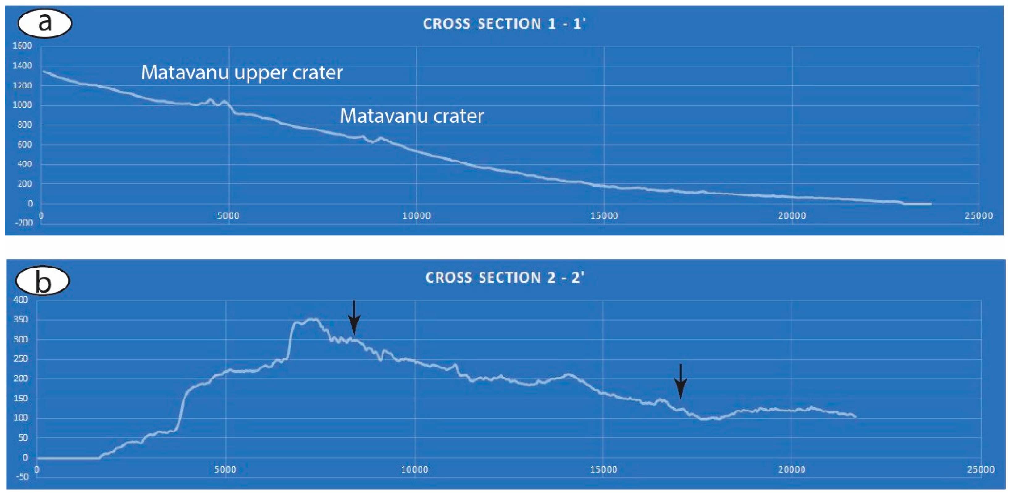
Figure 3.
A longitudinal (a) and perpendicular (b) lava flow cross section across the lava flow field of the Matavanu Eruption Site. In (b), arrows mark the approximate position of the lava margins. Distances in x-axis and y-axis are shown in meters.
Figure 3.
A longitudinal (a) and perpendicular (b) lava flow cross section across the lava flow field of the Matavanu Eruption Site. In (b), arrows mark the approximate position of the lava margins. Distances in x-axis and y-axis are shown in meters.

Figure 4.
London Missionary Society (LMS) Church at Sale’aula invaded by the lava flows. (a) Collapsed roof-plate marks clearly visible on the top of the lava (white circle). Typical pāhoehoe surface (b) and deflated lava pond with thick pāhoehoe crust (c) are common features in the distal flow field. Thin pāhoehoe lobes engulf the LMS Church (d) while the flow field terminus preserves inflated lava fields (e). Photos are provided by Ms Miranda MccDowell and taken on 3 September 2022.
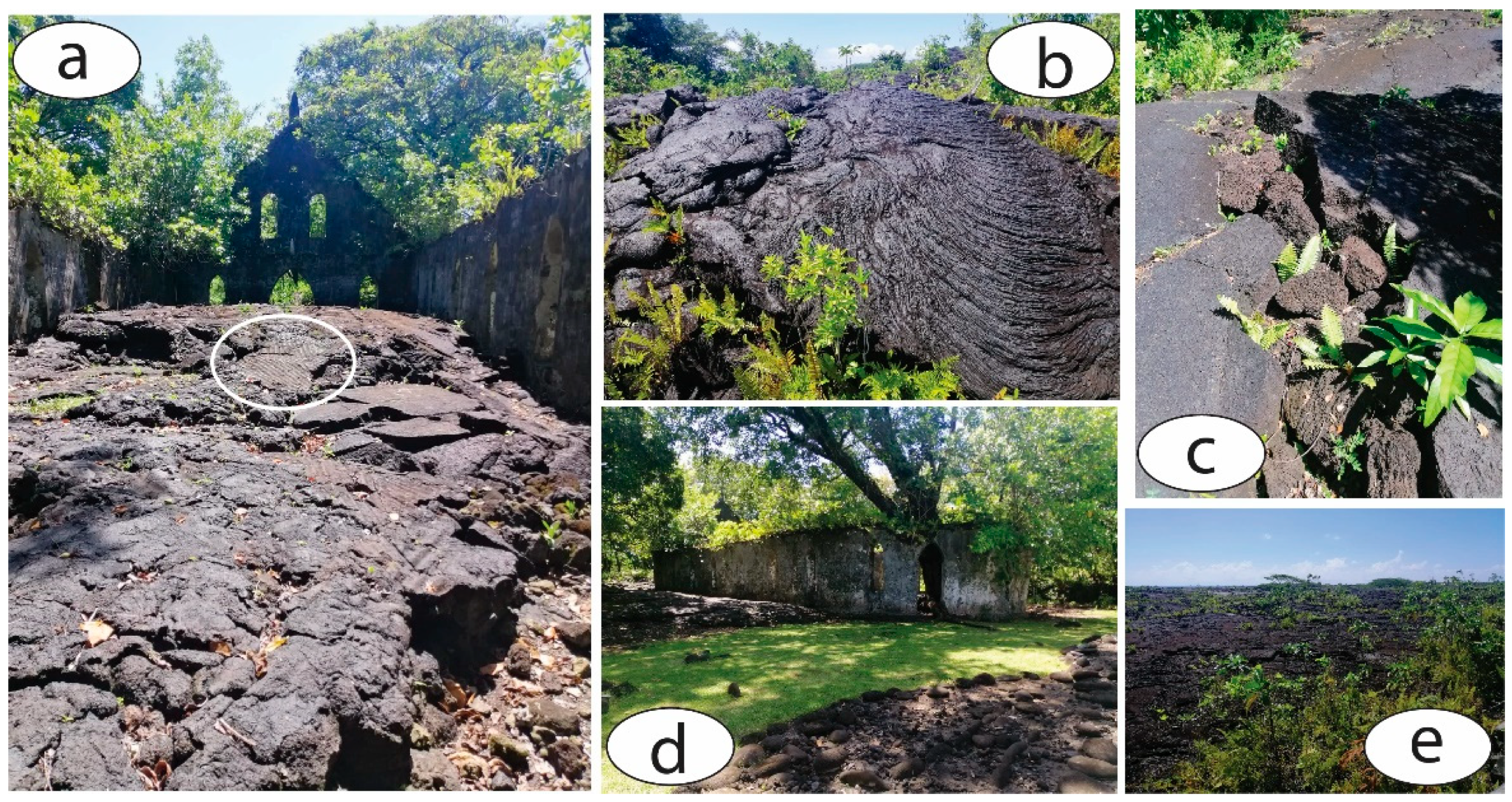
Figure 5.
Visible light satellite image (a) and Sentinel-2 Geology 8 11 12 band image (b) showing the young lava flow surfaces. The slope map (c) demonstrates a monotonous sloping terrain within the scoria; cones are marked as well as some deeply incised canyons along older lava flow margins. The geomorphon map (d) further demonstrates that the study area has monotonous landform classes within other landforms seemingly evenly distributed. Landform classes are (1) flat, (2) summit, (3) ridge, (4) shoulder, (5) spur, (6) slope, (7) hollow, (8) foot slope, (9) valley, and (10) depression.
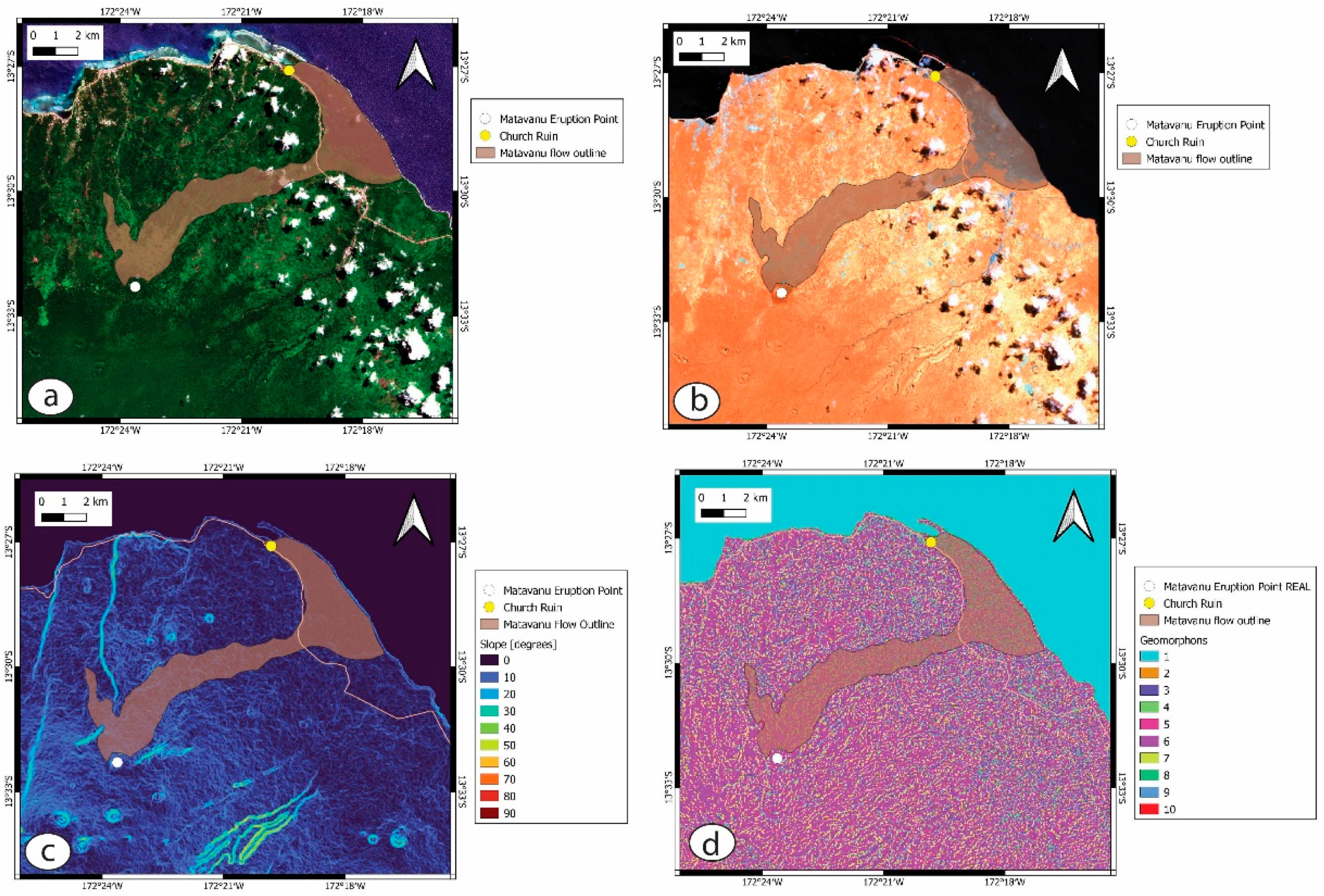
Figure 6.
Results of Q-LavHA lava flow simulations of the 1905–1911 Matavanu Eruption. Simulation distances were set to 13-km (a) to represent the maximum preserved flow distance and for 130-km (b) both following Euclidean simulations. Simulation yielded similar lava flow inundation that was slightly offset from the currently known mapped flow distribution patterns. Contour lines are in 10-m intervals while the known lava flow distribution is marked by the light brown field. Yellow dots mark the location of the LMS Church ruin while white dots represent the Matavanu eruption point.
Disclaimer/Publisher’s Note: The statements, opinions and data contained in all publications are solely those of the individual author(s) and contributor(s) and not of MDPI and/or the editor(s). MDPI and/or the editor(s) disclaim responsibility for any injury to people or property resulting from any ideas, methods, instructions or products referred to in the content. |
© 2022 by the author. Licensee MDPI, Basel, Switzerland. This article is an open access article distributed under the terms and conditions of the Creative Commons Attribution (CC BY) license (https://creativecommons.org/licenses/by/4.0/).
Share and Cite
MDPI and ACS Style
Németh, K. Geodiversity and Its Implication for Geoconservation of the Youngest Eruptive Sites of Western Samoa. Proceedings 2023, 87, 33. https://doi.org/10.3390/IECG2022-13751
AMA Style
Németh K. Geodiversity and Its Implication for Geoconservation of the Youngest Eruptive Sites of Western Samoa. Proceedings. 2023; 87(1):33. https://doi.org/10.3390/IECG2022-13751
Chicago/Turabian StyleNémeth, Károly. 2023. "Geodiversity and Its Implication for Geoconservation of the Youngest Eruptive Sites of Western Samoa" Proceedings 87, no. 1: 33. https://doi.org/10.3390/IECG2022-13751