Surface Fire to Crown Fire: Fire History in the Taos Valley Watersheds, New Mexico, USA


1
University of Minnesota, Cloquet Forestry Center, 175 University Drive, Cloquet, MN 55720, USA
2
U. S. Geological Survey, Fort Collins Science Center, New Mexico Landscapes Field Station, 301 Dinosaur Trail, Santa Fe, NM 87508, USA
*
Author to whom correspondence should be addressed.
Fire 2019, 2(1), 14; https://doi.org/10.3390/fire2010014
Submission received: 9 February 2019
/
Revised: 27 February 2019
/
Accepted: 8 March 2019
/
Published: 14 March 2019
Abstract
:Tree-ring fire scars, tree ages, historical photographs, and historical surveys indicate that, for centuries, fire played different ecological roles across gradients of elevation, forest, and fire regimes in the Taos Valley Watersheds. Historical fire regimes collapsed across the three watersheds by 1899, leaving all sites without fire for at least 119 years. Historical photographs and quaking aspen (Populus tremuloides Michx.) ages indicate that a high-severity fire historically burned at multiple high-elevation subalpine plots in today’s Village of Taos Ski Valley, with large high-severity patches (>640 ha). Low-severity, frequent (9–29-year median interval) surface fires burned on the south aspects in nearby lower elevation dry conifer forests in all watersheds. Fires were associated with drought during the fire year. Widespread fires commonly burned synchronously in multiple watersheds during more severe drought years, preceded by wet years, including fire in all three watersheds in 1664, 1715, and 1842. In contrast, recent local “large” wildfires have only burned within single watersheds and may not be considered large in a historical context. Management to promote repeated low-severity fires and the associated open stand structures is within the historical range of variability in the dry conifer forests of these watersheds. In the high-elevation, subalpine forests, different management approaches are needed, which balance ecological and socioeconomic values while providing public safety.
1. Introduction
The Taos Valley and Sangre de Cristo Mountains in northern New Mexico contain a complex mix of natural and cultural resources that present challenges similar to those faced by fire and natural resource managers across western North America. These resources include a large range of elevations and ecosystems that spans the lower to upper tree line and includes the tallest mountain in New Mexico, Wheeler Peak (4011 m); multiple federally designated Wilderness areas; Taos Pueblo, a UNESCO world heritage site continuously inhabited for over eight centuries; Taos Ski Valley (both the village and the ski resort); the forested watersheds of three perennial streams that are vital local water sources; and many rural communities located within and adjacent to the forest that depend directly on the ecosystem services provided by these natural resources, as well as the indirect benefits of tourism. Recent nearby fires have burned with large (>500 ha), high-severity patches (e.g., 1996 Hondo Fire, 2003 Encebado Fire, and 2018 Ute Park Fire) that have adversely impacted local communities, forests, and water resources. In response to increasing fire occurrences, local community organizations and land managers have formed collaborative groups with the goal of managing the protection of this broad range of resources across a landscape with a complex land ownership.
There is little information about the historical role of fire across the large elevational and ecological gradients of the Taos Valley Watersheds. Locally, the forests of the Taos region are sometimes referred to as “asbestos forests” due to the relative lack of fire over the modern management era. There is some historical evidence of large, high-severity fires (>1000 ha) prior to 1900 in the subalpine forests of the Sangre de Cristo Mountains [1] but not in the Taos Valley Watersheds. Furthermore, it is not clear if frequent, low-severity surface fires, which are common in warmer, drier conifer forests of the Southwest [2], were widespread in the mixed conifer forests of the Taos Valley Watersheds [3]. The extensive subalpine vegetation and rocky, topographically dissected landscape could have inhibited fires from spreading into the dry conifer forests from the adjacent stands under most conditions, potentially isolating the dry conifer forests from developing a frequent fire regime. Information on the historical fire regimes of the Taos Valley Watersheds was requested by local land managers and stakeholders to inform watershed and fire management.
Tree rings have been used to study the fire ecology of forests in the western U.S. since the early 20th century (e.g., in Refernce [4]). In 1924, Aldo Leopold [5] noted “universal fire scars” on trees old enough to bear them in southern Arizona. The first dendrochronologically cross-dated fire-scar study in New Mexico was conducted in the early 1980s in dry conifer (ponderosa pine and dry mixed conifer) forests of the Gila Wilderness in southern New Mexico [6]. In recent decades, tree-ring fire histories have advanced our understanding of fire regimes in a range of ecosystems across planet Earth (e.g., in Fennoscandia [7], Mongolia [8], and Patagonia [9]), as well as locally in New Mexico, including in piñon-juniper savannas [10], dry and wet mixed-conifer forests [11], and oak shrubfields [12]. These century-long records can provide information about historical fire frequency, severity, seasonality, and size and the fire–climate relationships prior to widespread grazing, timber harvest, and fire suppression [13]. Networks of cross-dated fire scars with sub-annual (seasonal) precision (Figure 1) can provide a unique and local understanding of the drivers of the spatial and temporal variabilities of fire regimes [14]. Combining tree rings with additional lines of evidence, such as historical photographs or forest surveys, can provide a more complete understanding of historical fire regimes and forest dynamics. Tree-ring fire histories also provide valuable site-specific data that can be used to identify if stands and landscapes have departed from historical conditions [15].
The goal of this research was to use multiple lines of evidence to reconstruct the history of fire across an elevational gradient in three forested watersheds (Rio Hondo, Rio Pueblo de Taos, and Rio Fernando) that provide water and numerous other ecosystem services to the Taos Valley. The specific objectives were (1) to reconstruct the history of fire in low-elevation, dry conifer forests of the three watersheds; (2) to reconstruct the history of fire in the high-elevation, subalpine forests of the Rio Hondo watershed, including and adjacent to Taos Ski Valley; (3) to quantify the relationship between historical fire occurrence and climate variability; and (4) to discuss the management implications of the results as they apply to the restoration of fire regimes and the forest structure in the Taos Valley Watersheds.
2. Materials and Methods
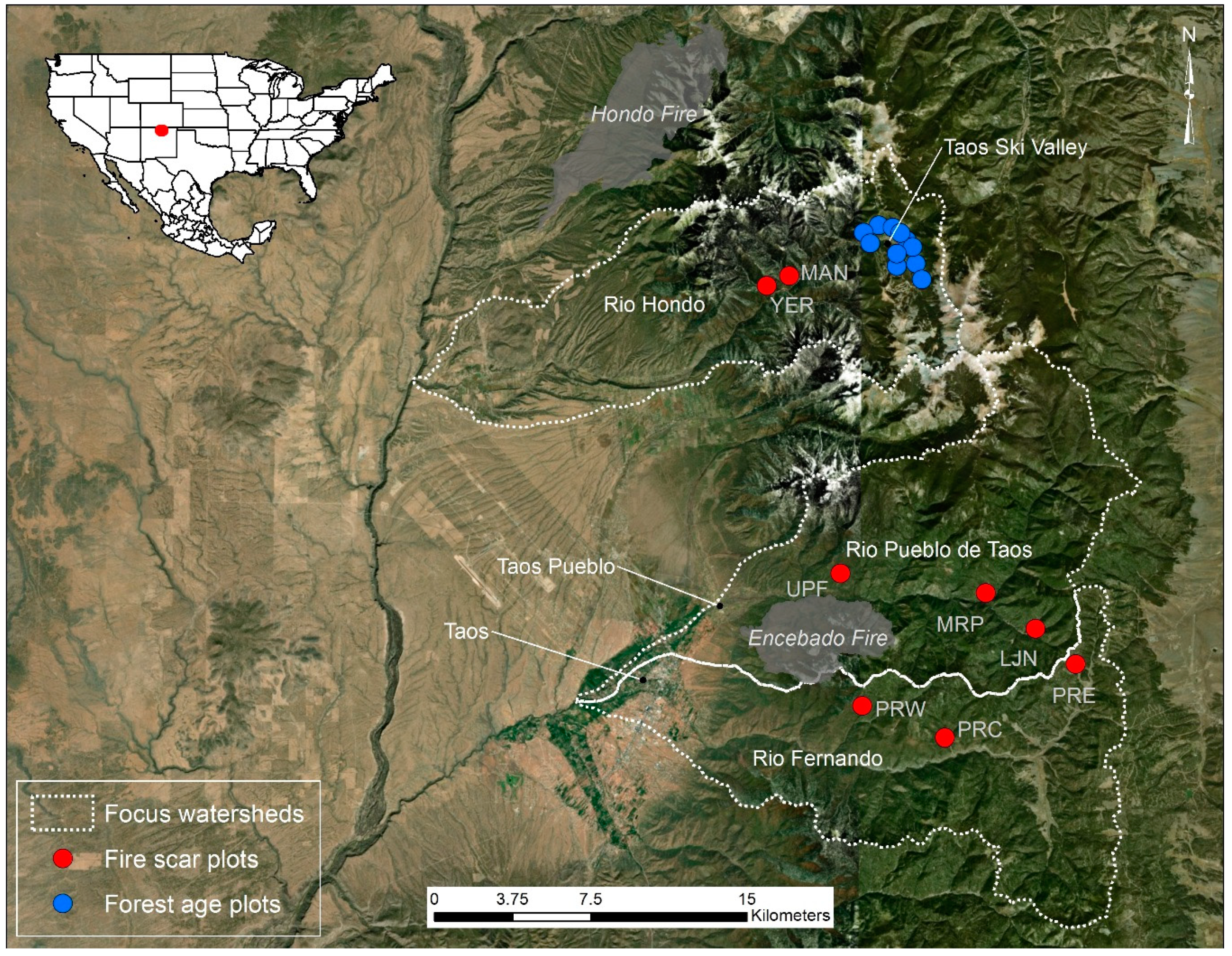
The study area is located on the west slope of the Southern Rockies in the Sangre de Cristo Mountains of northern New Mexico (36.5° N, 105.5° W, Figure 2). The three sampled Taos Valley watersheds include the Rio Hondo, Rio Pueblo de Taos, and Rio Fernando (Table 1). The elevation of the sample plots ranges from 2560 to 3289 m. The climate in the study area is continental and semiarid, with a bimodal precipitation regime. The summer precipitation is dominated by convective storms. The winter precipitation usually comes as snow and has a high interannual variability associated with the El Niño Southern Oscillation [16]. The average annual precipitation ranges from 59 cm to 92 cm among plots (1981–2010; [17]). The annual average minimum temperature ranges from −4.3 °C to −1.1 °C among plots, and the annual average maximum temperature ranges from 8.7 °C to 13.1 °C (1981–2010; [17]).
We sampled at the upper and lower ends of the ecological and elevation gradients present in the study area. The lower elevation forest was dry conifer, consisting of ponderosa pine and dry mixed conifer (mean plot elevation = 2679 m). The following tree species were present in the sampled dry conifer forest in descending order of abundance: ponderosa pine (Pinus ponderosa Lawson and C. Lawson), Douglas-fir (Pseudotsuga menziesii (Mirb.) Franco), southwestern white pine (P. strobiformis Engelm.), quaking aspen (Populus tremuloides Michx.), white fir (Abies concolor (Gord. and Glend.) Lindl. ex Hildebr.), and Rocky Mountain juniper (Juniperus scopulorum Sarg.). The upper-elevation forest was subalpine (mean plot elevation = 3103 m), including the following tree species: quaking aspen, Engelmann spruce (Picea engelmannii Parry ex Engelm.), Douglas-fir, and subalpine fir (A. lasiocarpa (Hook.) Nutt.). Southwestern white pine and P. flexilis James (limber pine) likely hybridized within the study area [18], but we considered the sampled fire-scarred trees and remnant wood to be southwestern white pine due to the growth form, site conditions, and elevation.
2.1. Field Methods
We used different tree-ring sampling methods for the dry conifer forests and the subalpine forest. In the dry conifer forests, we sampled fire scars at two to three plots on the south aspects in each of the three watersheds for a total of eight plots. We divided the watersheds into search areas so that the final plot locations were spatially distributed across the watershed (e.g., west, central, and east plots in the Rio Fernando; Figure 2). Within each search area, the final fire-scar plot locations were nonrandom and were specifically located where we found the best records of past fires (i.e., the most fire scars). The final fire-scar plots ranged in size from 1 to 3 hectares based on the density of available fire-scarred material. Full or partial tree cross sections were collected primarily from remnant stumps, snags, and logs with fire scars and on occasion from a live tree to obtain the most recent fire date at a plot. Sampling outside federally designated wilderness areas was conducted with a chainsaw. Plots in the Columbine-Hondo Wilderness were sampled with a crosscut saw. The coordinates of the sampled tree locations were recorded with a global positioning system, in addition to the tree species, tree condition, and sample height.
In the subalpine forests, we used forest-age sampling methods in the Rio Hondo watershed. The Rio Hondo watershed is of particular management importance because a community, a surface water supply, and the Taos Ski Valley are embedded in the subalpine forest. There is no subalpine forest in the Rio Fernando de Taos watershed, and the subalpine forest of the Rio Pueblo de Taos watershed has restricted access because of Blue Lake, a sacred site within Taos Pueblo. In the subalpine forest of the Rio Hondo, we sampled 11 forest-age plots spatially distributed within and adjacent to Taos Ski Valley to estimate the time since the last high-severity fire. This area of the upper Rio Hondo was chosen because it had the largest quaking aspen patches in the watershed that potentially represented evidence of a past fire.
Quaking aspen resprouts in high densities and grows quickly after being top-killed by fire; therefore, aspen ages can be useful in determining the dates and minimum extents of high-severity fire patches [1]. The majority of the plots (eight) were in aspen stands, but we also sampled three additional subalpine conifer plots adjacent to the aspen stands and on the south side of the watershed, in Taos Ski Valley, where discrete aspen patches are mostly absent. In the aspen patches, we collected two or more increment cores from the base of the four largest diameter aspen within a 10 m-radius plot. When wood rot was encountered, which occurred in roughly half of the sampled trees, the nearest aspen with a similar diameter was cored as a substitute. In the subalpine conifer forest adjacent to the aspen, we used an 18 m-radius plot and cored the eight largest diameter, rot-free conifers. We sampled a larger number of trees in conifer plots due to the more complex stand histories of postfire conifer stands when compared to resprouting, postfire aspen. All cores were collected to intercept pith or near-pith as close to the tree root collar as possible (≤0.3 m sample height). The inner-ring dates of the oldest trees in a plot were used to estimate the stand origin and the time since the last high-severity fire.
2.2. Lab Methods
The cross sections were thinned with a bandsaw, and the fragile samples were glued on plywood. The increment cores were glued to wooden mounts. The samples were sanded with progressively finer grits of sand paper until the annual growth rings were visible under magnification. The aspen cores were sanded by hand down to 15 micron grit paper to enable viewing of the diffuse-porous ring structure.
The samples were cross-dated using a visual approach and skeleton plots [19]. A master chronology of the limber pine ring widths from the adjacent Red River watershed (Italian Canyon, NM) was used as a reference. The samples that could not be visually dated were measured, and the ring widths were statistically compared to reference chronologies using the program COFECHA [20]. White rings in the quaking aspen cores associated with Western tent caterpillar (Malacosoma californicum Packard) defoliations were helpful dating markers within a plot.
Fire scars were dated to the year, and when possible, the intra-annual scar position was determined (Figure 1, [21]). The intra-annual positions include (i) dormant, (ii) early earlywood, (iii) middle earlywood, (iv) late earlywood, and (v) latewood. Dormant fires were assigned to the spring of the following year based on the predominance of early season scars and on the rarity of latewood scars among scars that occurred within the growing season in the study area. Spring-dormant scars likely correspond with the spring/early-summer occurrence of most large modern fires and with the historical fire seasonality and fire-climatology records derived from tree rings in northern New Mexico [2,22]. The tree-ring data and associated metadata are available from the International Multiproxy Paleofire Database (www.ncdc.noaa.gov/paleo/impd/paleofire.html).
2.3. Data Analysis
Fire frequency statistics (e.g., mean and median fire interval) were calculated for plot composites and for synchronous fires (i.e., multiple plots burned) using the “burnr” fire history package in R [23,24]. A composite of all the fire-scar years within a small plot is the best estimate of a “point” fire frequency [25] because individual trees are imperfect recorders of fire. Fire synchrony among the watersheds was quantified using the percent of plots recording fire and by mapping the locations of fire-scarred trees for each fire year.
The fire–climate relationships of fires with varying degrees of synchrony among plots were analyzed using a superposed epoch analysis (SEA, [26]) and a tree-ring reconstructed summer drought index (Palmer drought severity index (PDSI), grid point 1888, [27]). The antecedent conditions were evaluated, since relationships between the prior-year climate and the fire in subsequent years may provide the potential for fire forecasting (e.g., in [28]). The SEA was conducted using the burnr package in R [23].
3. Results
3.1. Dry Conifer Forest Fire History
Fire-scarred trees and logs were present, although not abundant, in the surveyed dry conifer forests of the three watersheds. Fire scars were mostly abundant on dry, south- and southwest-facing aspects between 2500–2800 m, which is where we located our fire-scar plots. We dated the fire-scarred samples from 73 trees at eight plots in three watersheds, including two plots in the Rio Hondo and three each in the Rio Pueblo and Rio Fernando (Table 1, Figure 2). Most of the fire-scarred trees were ponderosa pine (80%), but we also found fire-scarred southwestern white pine (14%), Douglas-fir (5%), and Rocky Mountain juniper (1%).
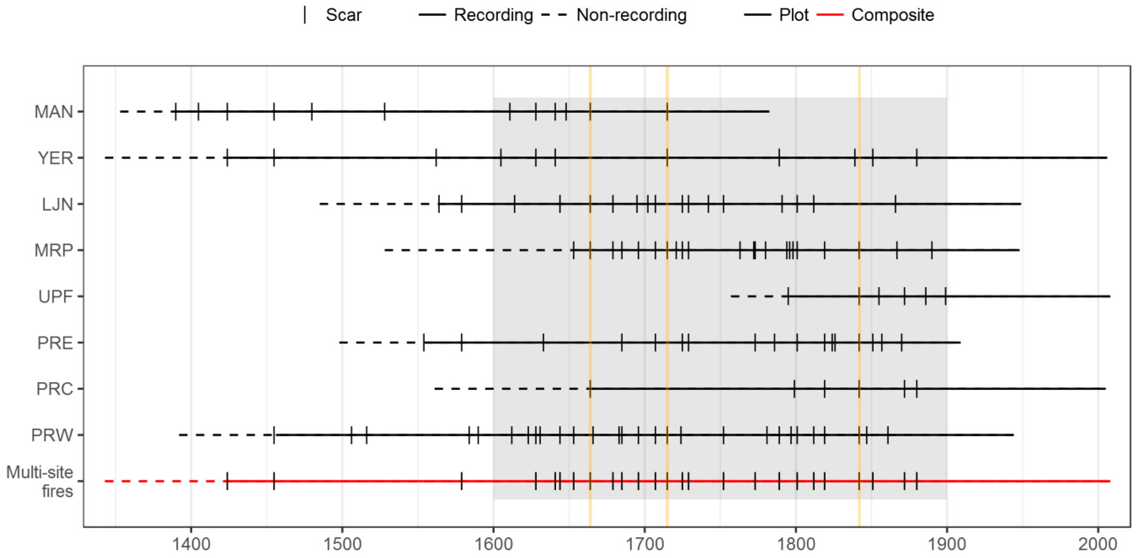
The tree-ring record spanned 1342–2009 CE, and we reconstructed 76 fire years (1390–1899 CE; Figure 3 and Figure 4). The plots with the oldest fire scars, which dated to the late 1300s and early 1400s, were both located in the Rio Hondo watershed (YER and MAN). Prior to 1900, high- to moderate-frequency fires burned within the sampled dry conifer forests (Table 2). The plot composite median fire intervals ranged from 9 to 29 years (1600–1899 CE), but some plots burned in back-to-back years or as infrequently as 74 years. The current fire-free interval at all plots (>119 years) is anomalous over at least the last three to four centuries. The long fire intervals at PRC and in the pre-1600 portions of other plots are likely due to a low sample size.
Synchronous fires burned multiple plots during 33% (n = 25) of the reconstructed fire years (1424–1880, Figure 4). The last synchronous fire occurred in 1880. Synchronous fires that burned two or more plots occurred every 12 years on average (1600–1899), and fires that burned four or more plots (>half of the plots) burned every 36 years on average (Table 3). Synchronous fire burned in two or more watersheds during 29% (n = 22) of the reconstructed fire years. Three years had synchronous fires in all three watersheds (1664, 1715, and 1842). The 1842 fire burned five of the six fire-scar plots in Rio Pueblo de Taos and Rio Fernando, as well as multiple aspen plots in the upper Rio Hondo (see Section 3.2).
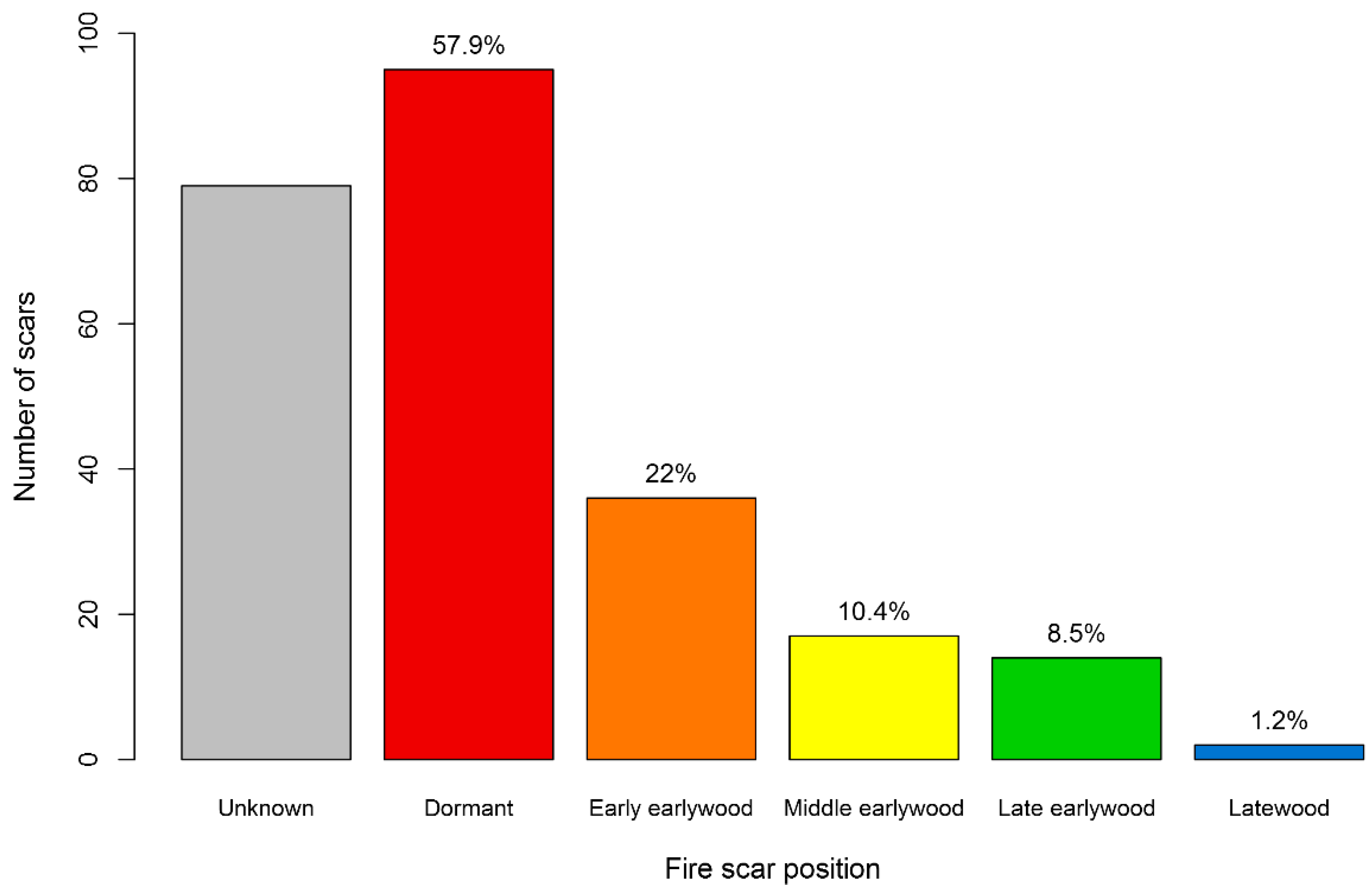
We were able to assign 68% of the fire scars (n = 165) an intra-ring (seasonal) scar position (Figure 5). The fire scars with unknown scar positions were due to narrow or eroded rings. Of the scars with assigned positions, 80% occurred in the spring or early summer (dormant or early earlywood scar positions, likely May or June). Ten percent occurred in the late-summer or fall (late earlywood or latewood scar position, likely September or early October).
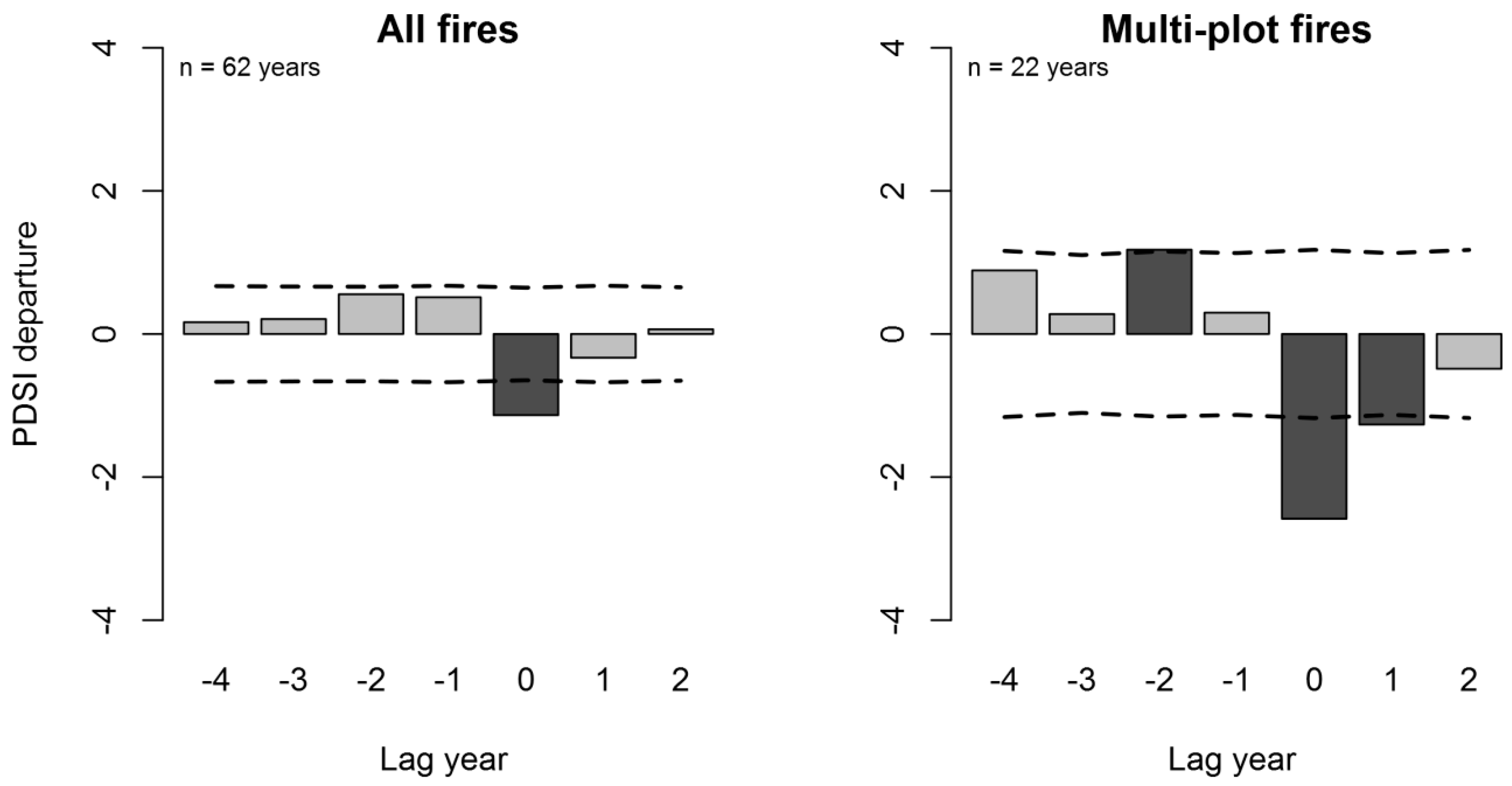
On average, fire years were significantly (p < 0.05) related to tree-ring-reconstructed drought during the fire year (negative PDSI departures, 1600–1899, Figure 6). Fires that burned one or more plots occurred during moderate drought conditions. Fires that burned multiple plots were associated with more severe droughts, preceded by wet conditions (p < 0.05).
3.2. Subalpine Forest Fire History
Fire-scarred material was rare in the steep, high-elevation, subalpine forests of the upper Rio Hondo watershed. We only found two old southwestern white pine logs with fire scars dating to 1562 and 1601 (locations noted in Figure 7). We sampled eleven forest-age plots, strategically targeting aspen patches where present (Table 4, Figure 2 and Figure 7). Eight of the sampled plots were aspen, two were aspen-conifer (Engelmann spruce and Douglas-fir), and one was spruce-fir.
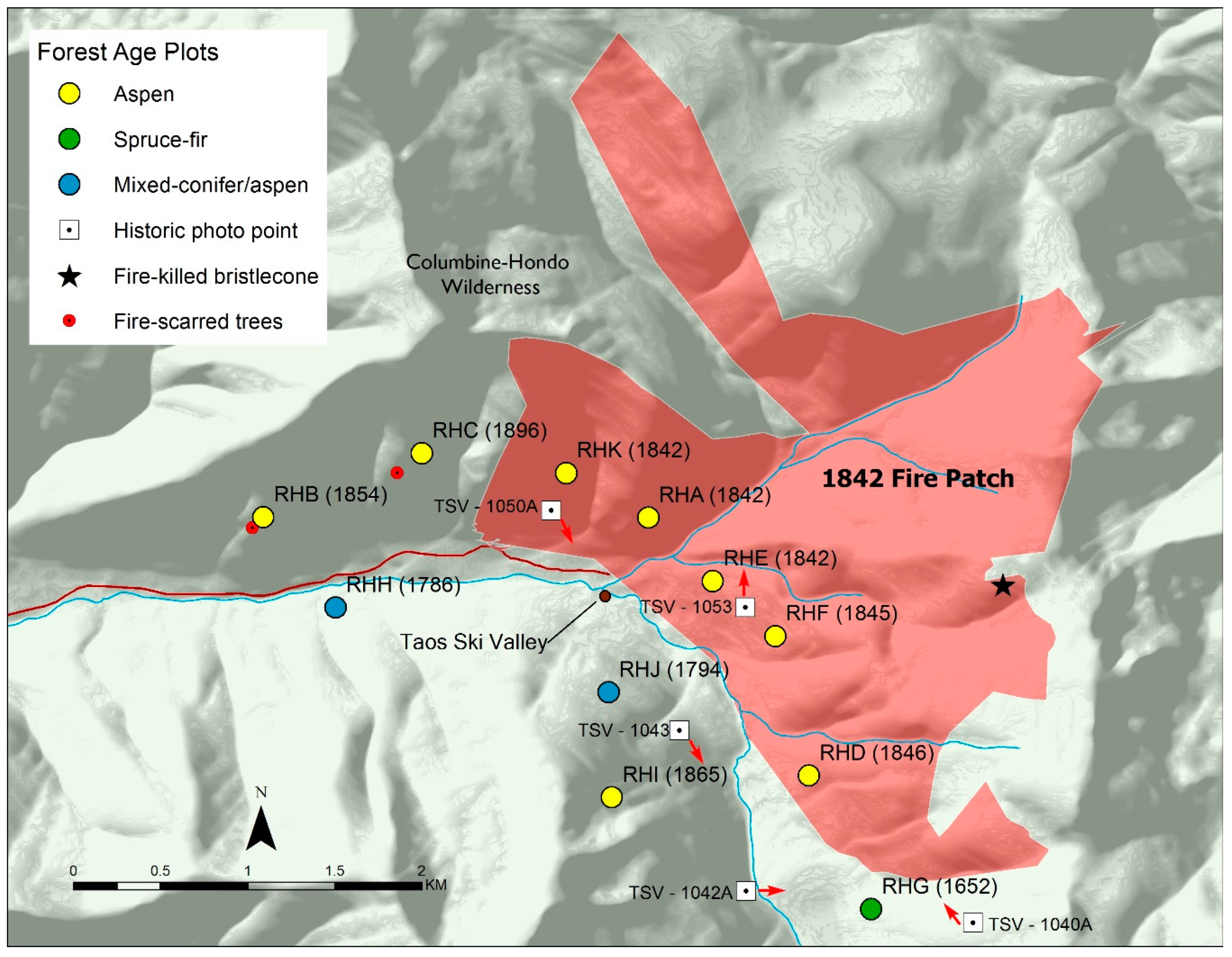
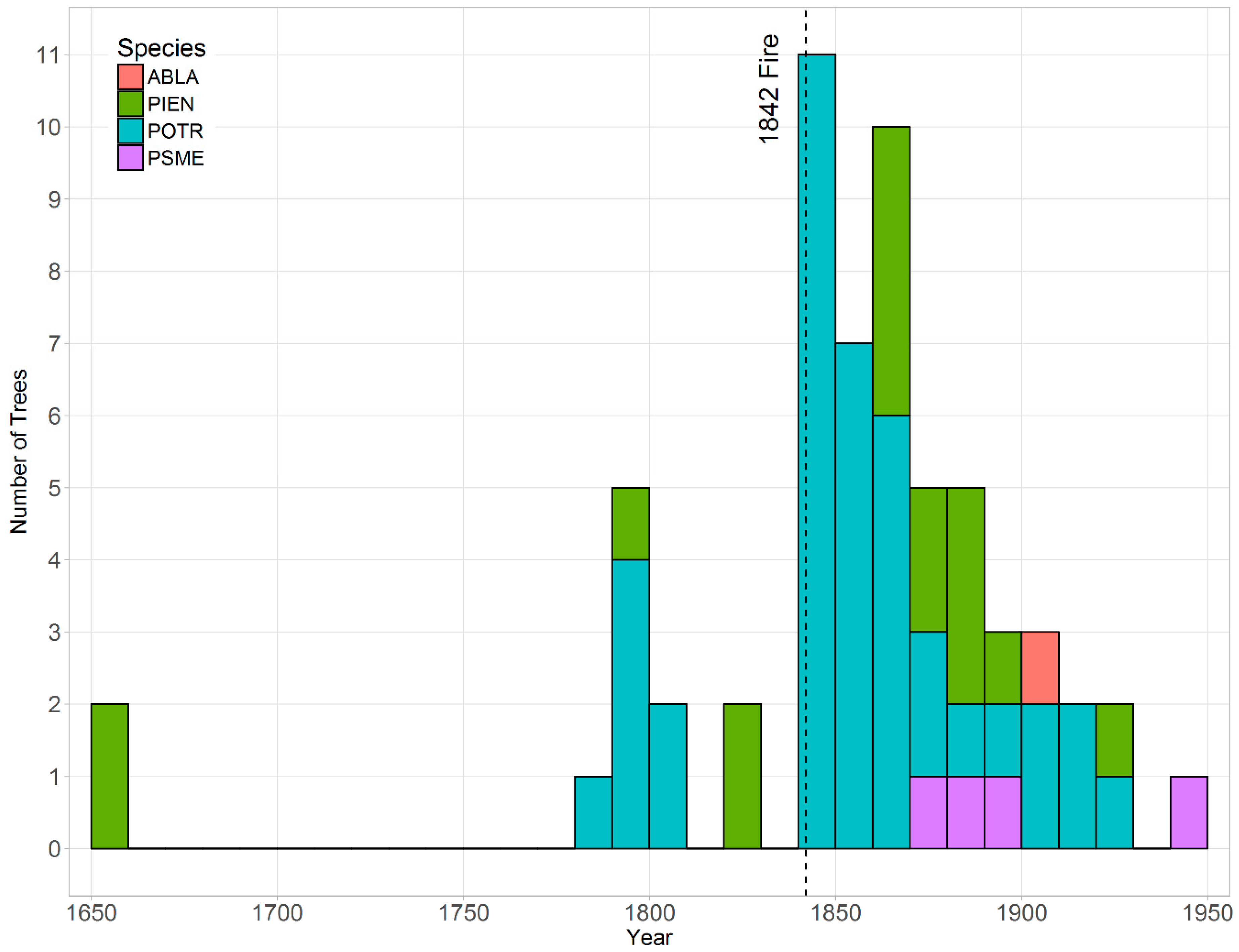
The decade of the oldest tree-ring dates for live trees at the age plots included the 1650s, 1780s, 1790s, 1840s, 1850s, 1860s, and 1890s, with the minimum estimated time since high-severity fire ranging from 122 years to 366 years (Figure 7 and Figure 8, Table 4). The largest and most synchronous pulse of aspen regeneration began in 1842 across five adjacent plots with multiple aspen pith dates in 1842. No living trees predate 1842 at these plots. This is interpreted as postfire regeneration from an 1842 high-severity fire on the south- and west-facing slopes in the upper Rio Hondo. Fire scars were recorded in 1842 throughout the dry conifer forests in the nearby Rio Pueblo de Taos and Rio Fernando drainages. An 1842 high-severity fire in the Rio Hondo is also supported by the presence of a fire-killed patch of Rocky Mountain bristlecone pine (P. aristata Engelm.) at the tree line upslope of aspen plots RHE and RHF. A fire-killed bristlecone snag opportunistically sampled from this stand (Figure 7) had an eroded outermost sapwood ring date of 1830 (and a 1601 pith date), consistent with being fire-killed in 1842.
The stand age dates from the aspen and conifer plots (Figure 7 and Figure 8) correspond with evidence of a high-severity fire visible in historical photographs taken circa 1903 (Figure 9 and Figure 10). Five of the photos were georeferenced and used in conjunction with the tree age data and terrain features including ridges and rock outcrops to estimate the minimum area of high-severity fire in the Rio Hondo in 1842 at 640 ha (Figure 7, Figure 9, and Figure 10). The total 1842 fire area was potentially larger, extending northeast, outside of the Rio Hondo basin, and into the upper Red River drainage, as well as to the south in the Rio Pueblo de Taos and Rio Fernando watersheds, where we found many trees with 1842 fire scars.
Additional aspen regeneration peaks occurred in the late 1780s, the early 1790s (plots RHH and RHJ), and the mid-1860s (plot RHI, Figure 7 and Figure 8). These potentially indicate additional high-severity disturbances, but we did not find additional tree-ring data (e.g., fire scars) for confirmation. The oldest forest patch (plot RHG) contained living spruce with inner rings in the 1650s (1652 and 1656) and was located on the southeast side of the upper Rio Hondo. This spruce-fir patch has not burned at high severity for at least 366 years and likely represents the southern boundary of the 1842 high-severity fire patch (Figure 7 and Figure 9).
4. Discussion
4.1. Subalpine Forests
Tree-ring fire history data and historical photographs from the upper elevation, subalpine forests of the Rio Hondo watershed indicate that the historical fire regime included large patches of mixed- and high-severity fires (>640 ha). This is supported by early 20th century surveys of forests and fire in the study area. A U.S. Geological Survey report for the proposed Taos Forest Reserve [29], which later became the Carson National Forest, contains the following descriptions by Vernon Bailey of the upper elevation, subalpine forests in 1903:
“The greater part of the forest has been burned over once, or many times, and now stands as a mixed second growth of poplars [quaking aspen] and spruces or as dense poplar groves or tangled windfalls of bare logs. Here and there narrow strips of trim fir and balsam trunks have escaped the fire and still stand dense and clean, while some extensive areas above 10,000 feet have never been burned, so that looking down from the peaks one sees beautiful dark stretches of forest. In the lower part of the zone many of the poplar groves have escaped the fire for years, so that the trees have reached a diameter of 10 or 12 inches, with tall, straight trunks standing close together. Generally when the spruces are burned off, aspens take their place and soon cover the ground, but in places young aspens and conifers are mixed, forming dense, almost impenetrable thickets.”(p. 7)
Bailey describes a high-elevation forest mosaic that was strongly influenced by a high-severity fire. The emphasis on “burned over” and “second growth” stands of aspen suggests that patches of postfire aspen regeneration were periodically created and maintained by fires at the higher elevations. These descriptions of the subalpine forests are consistent with our findings of 122- to 232-year-old postfire aspen patches in the upper Rio Hondo watershed, which would have been 7 to 117 years old in 1903.
The lack of young aspen stands today in the subalpine forest is notable when compared to the early 1900s observations. This could be the results of multiple factors, including (1) anomalously high fire occurrences in the decades prior to Bailey’s observations (possibly because of human ignitions) and (2) anomalously low fire occurrences over the last century due to fire exclusion or climate variability, or a combination of these or other factors. In subalpine aspen-conifer forests of western Colorado, a high fire occurrence in the late 1800s, partially attributed to human land use, resulted in an increased aspen cover ca. 1900 [30]. Fire occurrences were not anomalously high in the late 1800s in the dry conifer forests of our study area, but the lack of fires over the last century is exceptional (Figure 3 and Figure 4). This raises the possibility that fire regimes in the subalpine forests are spatially linked to the dry conifer forests through fire spread during severe drought and that fire exclusion in the dry conifer forests could effectively reduce fires in the subalpine forests. The 1842 high-severity fire patch in the subalpine forests of the Rio Hondo burned during the most widespread fire year in the dry conifer forests. Widespread fire burned across elevation gradients during drought years in the 19th century in the southern Sangre de Cristo Mountains [31]. Modern fires near the study area (e.g., Hondo Fire) have burned across the elevation gradient, from dry conifer forests to subalpine forests. This possible direct link between fire regimes of the upper- and lower-elevation forests through fire spread suggests that fire exclusion in the dry conifer forest could reduce fire occurrences in the adjacent subalpine forests by reducing the number of ignitions that can spread from lower elevations, and vice versa.
4.2. Dry Conifer Forests
The tree-ring fire-scar data indicate a history of frequent, low-severity fires strongly influenced by climate variability in the dry, south-facing conifer forests of the Taos Valley Watersheds. The range of median fire intervals (9 to 29 years) is within the range reported in the ponderosa pine and dry mixed-conifer forests of the Southwest [2,11,32,33], with the multi-decadal intervals on the high end. The exceptionally long, 29-year median interval in ponderosa pine at YER in the Rio Hondo is possibly due to the rugged topography and adjacency to mesic mixed-conifer and subalpine forests that are not conducive to frequent fires. The results of the fire–climate analysis—widespread fire associated with drought during the fire year, preceded by wet conditions—are similar to other dry conifer sites in the Southwest [2,34,35] and suggest that the projected increase in temperature and drought stress will increase the probability of widespread fires in the future, at least until fuels become limited [36,37].
Historical surveys in the dry conifer forests of the study area are consistent with the tree-ring records of a fire regime dominated by low-severity fires. Early 1900s timber surveys (Township 25 N, Range 14 E, [29]) include the middle and lower Rio Fernando drainage and part of the Rio Pueblo de Taos drainage, where our fire-scar plots PRW and PRC are located. The surveys indicate that these forests were dominated by red fir (Douglas-fir) (59%) and ponderosa pine (14.9%) and that 20% (1889 ha) was classified as “burnt land” (p. 16). We infer “burnt land” to mean severely burned due to the language associated with fire in the report, such as the observation that this area was “ravaged by numerous and periodical fires destroying…timber…” that “with the exception of a few instances has been restocked with quaken asp [sic]” (p. 15). It is challenging to reconcile this sensational language (e.g., “ravaged” and “fires destroying timber”) with the actual surveys that indicate only 20% was burned. The purpose of the surveys was to identify areas for timber harvest; therefore, they likely viewed fire negatively as a cause of timber and economic loss, which was an emerging theme in forest management at the time [38]. The fact that 80% of the surveyed area was not mapped as “burnt land,” combined with our fire-scar plots that contain many trees that survived repeated fire into the late 1800s, suggests that most of this dry conifer forest area was not “ravaged” by fire and likely burned historically with low to mixed fire severity.
Additional timber surveys (Township 25 North, Range 15 East, [29]) include the upper third of the Rio Fernando and Rio Pueblo de Taos watersheds and our fire-scar plots PRE and LJN. The south- and east-facing slopes of the township were described as “generally sparsely covered with Yellow pine” with the west and north slopes being “very heavily timbered” (p. 17). Only 4% (225 ha) of this area was classified as “burnt land” (p. 18). The combined evidence of (1) historical observations of a small proportion of (severely) burnt land, (2) the variability in forest type and density by aspect, and (3) a tree-ring record of frequent low-severity fires at the south-facing fire-scar plots but the lack of fire scars at other surveyed locations suggests historical low- to mixed-severity fire regimes that varied spatially by elevation and slope aspect in the mixed conifer forests.
4.3. Modern Fires in a Historical Context
Several wildfires have recently burned with high-severity close to Taos. The Hondo Fire burned north of the study area, primarily with high-severity, in May 1996 (3045 ha), and the Encebado Fire burned in the Rio Pueblo de Taos watershed in July 2003 (2185 ha, Figure 2). These were viewed locally as large fires, although they were primarily confined to single drainages. Much larger fires have recently occurred in similar forest types in northern New Mexico, including the 2000 Viveash fire in the southern Sangre de Cristo Mountains (11,735 ha), the 2002 Ponil Complex in the Sangre de Cristo Mountains north of the study area (37,312 ha), and the 2011 Las Conchas fire (63,131 ha) in the Jemez Mountains. Our fire history data indicates that in 1664, 1715, and 1842, fire burned synchronously in all three sampled Taos Valley Watersheds, with the 1842 fire likely burning greater than 5,660 ha (convex hull of the plots scarred in 1842). Fire synchrony in all three watersheds may have been caused by fire spread across the landscape or from multiple fires burning within the study area in the same year. While we did not sample with the goal of reconstructing the area burned, the relatively widespread historical fire synchrony among these watersheds suggests that, in the centuries prior to 1900, fires burned in this landscape with relatively large spatial extents not yet seen in the modern fire management era [39].
4.4. Management Implications—Dry Conifer Forests
The fire-scar-based reconstructions indicate that frequent, low-severity surface fires were an important ecological process for centuries in the mid-elevation (2500–2800 m) south-facing aspects of the Taos Valley Watersheds. In these locations and likely in other similar topographic settings, low-severity fires have been absent for at least 119 years. This is consistent with the pattern of historically frequent fire regime disruptions in the late 19th century by intensive livestock grazing—facilitated by the mass transport of sheep by railroad—that occurred in other dry conifer forests in northern New Mexico [11,40] and across the Southwest [2,41]. Without fires to thin out young trees, dry conifer forests often increase in tree density following fire exclusion [11,42]. The increased tree density and accumulation of woody fuels create high fuel loads and increases canopy cover, ladder fuel structures, and the risk of large, high-severity fires that are catastrophic to dry conifer ecosystems and watersheds [43,44,45]. These uncharacteristic, large high-severity fires in dry conifer forests of the region are consistently followed by a long-lasting alteration of hydrological processes including the elevated risk of severe flooding, heavy soil erosion, and damage to infrastructure [46].
The restoration of surface fire regimes in frequent-fire forests is increasingly becoming a management goal with a variety of benefits, including the restoration of fires as an important ecosystem process [47], increased forest and watershed resilience to future fires [48], potential increased tree resilience to climate change through reduced stand densities and competition for resources [49], potential increased resilience to insect outbreaks [50], as well as reduced risk of undesired geomorphic and hydrologic effects of a watershed-scale high-severity fire [46]. Where current fuel loads and tree densities are low, planned fire—or managed, unplanned fire—may be effective without prior mechanical treatments. In other locations, mechanical treatments prior to burning are necessary to reduce a century of fuel accumulation and to mitigate the risks of high-severity fires [51]. The pre-1900 low-severity fire regime plots sampled in this study and analogous forests in similar landscape positions could be priority locations for fire regime restoration treatments that break up the continuity of fuels in strategic landscape settings.
4.5. Management Implications—Subalpine Forests
The upper Rio Hondo watershed contains extensive subalpine conifer and aspen forests that historically burned with large (>640 ha) patches of high-severity fire. Historical photos, early 20th century forest descriptions, the current forest mosaic, and the tree ages are all consistent with the occurrence of a high-severity fire in these upper elevation forests prior to the 20th century. The 1842 fire in the upper Rio Hondo occurred during a severe drought and burned with large high-severity patches all the way through the bristlecone pine forest to the tree line. This is consistent with other tree-ring records of a high-severity fire in the subalpine conifer and aspen forests in northern New Mexico, including the Columbine-Hondo wilderness north of the study area, the Valle Escondido south of the study area, the Santa Barbara drainage, and the west slopes of Santa Fe Baldy [1], and in the upper Santa Fe River watershed [31] and subalpine forests in Colorado [52] and Arizona [53].
The management of these subalpine forests can be challenging due to potential conflicts between the ecologically important occurrence of high-severity fires, the assets at risk in the wildland-urban interface, and the socially desired ecosystem services (e.g., forest cover for aesthetics and stable watersheds that provide flood mitigation and water supplies). Managed fires in the subalpine forests pose obvious risks but could potentially be conducted under limited conditions. Once ignited in sufficiently dry or windy conditions, fires burning in subalpine forests exhibit a high-severity, crown-fire behavior that poses extreme risks to human life and infrastructure. Quaking aspen stands generally burn with a lower intensity than adjacent conifer forests and may be used strategically in fire suppression efforts [54]; however, under extreme drought and fire weather conditions, aspen forests may also sustain crown fires (e.g., 2010 Medano Fire [55]). Recent high-severity fires in subalpine forests of the region have also shown that the postfire flooding and debris flows can pose as much risk to human lives, infrastructure, and ecosystems services as the fire. The tight historical link between severe drought and high-severity fire occurrence in local subalpine forests [56] and wet mixed-conifer forests [11] suggests that fire risk will continue to increase with projected increases in drought severity and duration due to climate change in this region [36,37].
4.6. Mixed-Severity Fire Regimes
The reconstruction of historical fire regimes across a range of forest types, elevations, and fire severity can be challenging because tree-ring fire scars are not uniformly created or preserved [57]. The presence of fire scars on multiple adjacent trees is strong evidence of a low-severity fire. The opposite case, the lack of obvious fire scars, can be hard to interpret—is the absence of evidence (fire scars) evidence for the absence of low-severity fire? We sampled the dry conifer forests and the subalpine forests but did not sample the wetter mixed-conifer forest in between. Fire-scarred wood was rare adjacent to our fire-scar plots, particularly on the wet north- or east-facing aspects dominated by Douglas-fir. On Douglas-fir trees, open “cat face” fire-scar wounds are uncommon, but buried fire scars are common [11,58], so the evidence of a past low-severity fire could be present but hidden. Alternatively, the absence of fire scars in these mesic mixed-conifer sites could also be evidence of high-severity fire patches. The latter could suggest a mixed-severity fire regime, where low- and high-severity patches are intermixed across a landscape through time [59]. Fire history in similar mixed-conifer sites in the region suggests that they historically burned at low- to mixed-severities at multi-decadal intervals [11,57] with high-severity patches up to 100 ha [11,34,57]. Future dendroecological research could assess the historical range of high-severity patch sizes in the wet mixed-conifer forests situated between the dry conifer forests that burned primarily with low-severity fires and the subalpine forests that burned primarily with high-severity fires.
4.7. Fire Regime Summary and Future Fire Regimes
The range of elevations and forest types in the Taos Valley Watersheds resulted in a range of historical fire regimes. In the low-elevation dry conifer forests, we primarily searched for and sampled plots that had evidence of repeated, low-severity fires. Our field observations of dispersed fire scars and moderately frequent fire suggest that low-severity fires were historically present in the study area but less frequent and possibly less widespread than in more-xeric landscapes like the Jemez Mountains of New Mexico. At the opposite end of the spectrum of fire regimes, we targeted high-elevation aspen and subalpine conifer sites in the upper Rio Hondo that historically burned infrequently with high-severity. We did not sample in the mid- to-upper elevation, wet mixed-conifer forests that likely had a mixed-severity fire regime. Future research may be desired to quantify the fire regime metrics in this middle elevation forest, particularly the distribution of high-severity patch sizes. Current forest conditions have shifted to a state where large patches of high-severity fire could burn across the full elevation and forest gradient due to an increased vertical and horizontal fuel continuity from over a century without fires [60], exacerbated by observed and projected increases in drought severity and duration [37]. Models of future climate, vegetation, and fire regimes project continued fire-induced changes to the forests and watersheds of northern New Mexico. For example, a warmer and more-arid Southwest could shift species as well as fire regimes to higher elevations. The historically frequent surface fire regimes of the dry conifer forests may become fuel-limited at lower elevations but could move upslope into the future bioclimatic space of present-day wet mixed-conifer forests [61]. An increased understanding of past and projected changes in fire regimes and the drivers of these changes will be important to consider when managing fire, forests, and watersheds in the coming decades, particularly for communities that depend on the ecosystem services provided by these forested watersheds.
Author Contributions
Conceptualization: L.B.J. and E.Q.M.; formal analysis: L.B.J. and E.Q.M.; investigation: L.B.J. and E.Q.M.; methodology: L.B.J. and E.Q.M.; writing—original draft: L.B.J. and E.Q.M.
Funding
Funding was provided by the U.S. Geological Survey (USGS) Land Change Science Program and the Western Mountain Initiative, Taos Ski Valley Foundation, The Nature Conservancy, the Rio Grande Water Fund, the Carson National Forest, and the Village of Taos Ski Valley.
Acknowledgments
R. Corral, R. Scram, R. Romero, P. Kopepassah, R. Bean, P. Brewer, C. Mogen, B. French, K. Beeley, and C. Guiterman provided field or technical assistance. We thank C. Haffey, C. Allen, L. McCarthy, and T. Swetnam for their assistance in the initial stages of the project. M. Lopez assisted with the maps. R. Pattison of Pattison Land Trust provided logistical support and field access. M. Blake and the Village of Taos Ski Valley provided access to digital scans of historical photos. Additional support was provided by the Taos Valley Watershed Coalition and Taos Pueblo. J.T. Stevens and three anonymous reviewers provided comments that improved the manuscript. Any use of trade, firm, or product names is for descriptive purposes only and does not imply endorsement by the U.S. Government.
Conflicts of Interest
The authors declare no conflict of interest. The funders had no role in the design of the study; in the collection, analyses, or interpretation of data; in the writing of the manuscript; and in the decision to publish the results.
References
- Margolis, E.Q.; Swetnam, T.W.; Allen, C.D. A stand-replacing fire history in upper montane forests of the Southern Rocky Mountains. Can. J. For. Res. 2007, 37, 2227–2241. [Google Scholar] [CrossRef]
- Swetnam, T.W.; Baisan, C.H. Historical Fire Regime Patterns in the Southwestern United States Since AD 1700; USDA Forest Service RM-GTR-286; US Forest Service: Washington, DC, USA, 1996; pp. 11–32.
- Skinner, T.V. Fire Management Plan for the Taos-Blue Lake Wilderness Area; Santa Fe Institute: Santa Fe, NM, USA, 1988. [Google Scholar]
- Clements, F.E. The Life History of Lodgepole Burn Forests; USDA Forest Service: Washington, DC, USA, 1910; Volume Bulletin 7.
- Leopold, A. Grass, brush, timber, and fire in southern Arizona. J. For. 1924, 22, 1–10. [Google Scholar]
- Swetnam, T.W.; Dieterich, J.H. Fire history of ponderosa pine forests in the Gila Wilderness, New Mexico. In Wilderness Fire Symposium, Proceedings of the SYMPOSIUM and Workshop on Wilderness Fire, Missoula, MT, USA, 15–18 November 1983; USDA Forest Service INT-182; US Forest Service: Washington, DC, USA, 1985; pp. 390–397. [Google Scholar]
- Drobyshev, I.; Bergeron, Y.; de Vernal, A.; Moberg, A.; Ali, A.A.; Niklasson, M. Atlantic SSTs control regime shifts in forest fire activity of Northern Scandinavia. Sci. Rep. 2016, 6, 22532. [Google Scholar] [CrossRef] [PubMed] [Green Version]
- Hessl, A.E.; Ariya, U.; Brown, P.; Byambasuren, O.; Green, T.; Jacoby, G.; Sutherland, E.K.; Nachin, B.; Maxwell, R.S.; Pederson, N.; et al. Reconstructing fire history in central Mongolia from tree-rings. Int. J. Wildl. Fire 2012, 21, 86–92. [Google Scholar] [CrossRef]
- Mundo, I.A.; Villalba, R.; Veblen, T.T.; Kitzberger, T.; Holz, A.; Paritsis, J.; Ripalta, A. Fire history in southern Patagonia: Human and climate influences on fire activity in Nothofagus pumilio forests. Ecosphere 2017, 8. [Google Scholar] [CrossRef]
- Margolis, E.Q. Fire regime shift linked to increased forest density in a piñon-juniper savanna landscape. Int. J. Wildl. Fire 2014, 23, 234–245. [Google Scholar] [CrossRef]
- Margolis, E.Q.; Malevich, S.B. Historical dominance of low-severity fire in dry and wet mixed-conifer forest habitats of the endangered terrestrial Jemez Mountains salamander (Plethodon neomexicanus). For. Ecol. Manag. 2016, 375, 12–26. [Google Scholar] [CrossRef]
- Guiterman, C.H.; Margolis, E.Q.; Allen, C.D.; Falk, D.A.; Swetnam, T.W. Long-Term Persistence and Fire Resilience of Oak Shrubfields in Dry Conifer Forests of Northern New Mexico. Ecosystems 2017, 21, 943–959. [Google Scholar] [CrossRef]
- Harley, G.L.; Baisan, C.H.; Brown, P.M.; Falk, D.A.; Flatley, W.T.; Grissino-Mayer, H.D.; Hessl, A.; Heyerdahl, E.K.; Kaye, M.W.; Lafon, C.W.; et al. Advancing dendrochronological studies of fire in the United States. Fire 2018, 1, 11. [Google Scholar] [CrossRef]
- Merschel, A.G.; Heyerdahl, E.K.; Spies, T.A.; Loehman, R.A. Influence of landscape structure, topography, and forest type on spatial variation in historical fire regimes, Central Oregon, USA. Landsc. Ecol. 2018, 33, 1195–1209. [Google Scholar] [CrossRef]
- Johnston, J.D.; Bailey, J.D.; Dunn, C.J. Influence of fire disturbance and biophysical heterogeneity on pre-settlement ponderosa pine and mixed conifer forests. Ecosphere 2016, 7, 1–19. [Google Scholar] [CrossRef]
- Sheppard, P.R.; Comrie, A.C.; Packin, G.D.; Angersbach, K.; Hughes, M.K. The climate of the US Southwest. Clim. Res. 2002, 21, 219–238. [Google Scholar] [CrossRef] [Green Version]
- PRISM Climate Group, Oregon State University. Available online: http://prism.oregonstate.edu (accessed on 17 June 2018).
- Menon, M.; Bagley, J.C.; Friedline, C.J.; Whipple, A.V.; Schoettle, A.W.; Leal-Sàenz, A.; Wehenkel, C.; Molina-Freaner, F.; Flores-Rentería, L.; Gonzalez-Elizondo, M.S.; et al. The role of hybridization during ecological divergence of southwestern white pine (Pinus strobiformis) and limber pine (P. flexilis). Mol. Ecol. 2018, 27, 1245–1260. [Google Scholar] [CrossRef]
- Stokes, M.A.; Smiley, T.L. An Introduction to tree-Ring Dating; University of Chicago: Chicago, IL, USA, 1968. [Google Scholar]
- Holmes, R.L. Computer-assisted quality control in tree-ring dating and measurement. Tree-Ring Bull. 1983, 43, 69–78. [Google Scholar]
- Baisan, C.H.; Swetnam, T.W. Fire history on a desert mountain range: Rincon Mountain Wilderness, Arizona, U.S.A. Can. J. For. Res. 1990, 20, 1559–1569. [Google Scholar] [CrossRef]
- Margolis, E.Q.; Woodhouse, C.A.; Swetnam, T.W. Drought, multi-seasonal climate, and wildfire in northern New Mexico. Clim. Chang. 2017, 142, 433–446. [Google Scholar] [CrossRef]
- Malevich, S.B.; Guiterman, C.H.; Margolis, E.Q. burnr: Fire history analysis and graphics in R. Dendrochronologia 2018, 49, 9–15. [Google Scholar] [CrossRef]
- R Development Core Team. R: A Language and Environment for statistical Computing; R Development Core Team: Vienna, Australia, 2017. [Google Scholar]
- Farris, C.A.; Baisan, C.H.; Falk, D.A.; Yool, S.R.; Swetnam, T.W. Spatial and temporal corroboration of a fire-scar-based fire history in a frequently burned ponderosa pine forest. Ecol. Appl. 2010, 20, 1598–1614. [Google Scholar] [CrossRef]
- Swetnam, T.W. Fire history and climate change in giant sequoia groves. Science 1993, 262, 885–889. [Google Scholar] [CrossRef]
- Cook, E.R.; Seager, R.; Heim, R.R.; Vose, R.S.; Herweijer, C.; Woodhouse, C.A. Megadroughts in North America: Placing IPCC projections of hydroclimatic change in a long-term palaeoclimate context. J. Quat. Sci. 2010, 25, 48–61. [Google Scholar] [CrossRef]
- Westerling, A.L.; Gershunov, A.; Brown, T.J.; Cayan, D.R.; Dettinger, M.D. Climate and wildfire in the western United States. Bull. Am. Meteorol. Soc. 2003, 84, 595–604. [Google Scholar] [CrossRef]
- United States Geological Survey. Preliminary Report of the Examination of a Portion of the Taos Reserve, New Mexico; United States Geological Survey: Washington, DC, USA, 1904.
- Kulakowski, D.; Veblen, T.T.; Drinkwater, S. The persistence of quaking aspen (Populus tremuloides) in the Grand Mesa area, Colorado. Ecol. Appl. 2004, 14, 1603–1614. [Google Scholar] [CrossRef]
- Margolis, E.Q.; Balmat, J. Fire history and fire-climate relationships along a fire regime gradient in the Santa Fe Municipal Watershed, NM, USA. For. Ecol. Manag. 2009, 258, 2416–2430. [Google Scholar] [CrossRef]
- Iniguez, J.M.; Swetnam, T.W.; Yool, S.R. Topography affected landscape fire history patterns in southern Arizona, USA. For. Ecol. Manag. 2008, 256, 295–303. [Google Scholar] [CrossRef] [Green Version]
- Korb, J.E.; Fulé, P.Z.; Wu, R. Variability of warm/dry mixed conifer forests in southwestern Colorado, USA: Implications for ecological restoration. For. Ecol. Manag. 2013, 304, 182–191. [Google Scholar] [CrossRef]
- Bigio, E.R.; Swetnam, T.W.; Baisan, C.H. Local-scale and regional climate controls on historical fire regimes in the San Juan Mountains, Colorado. For. Ecol. Manag. 2016, 360, 311–322. [Google Scholar] [CrossRef]
- Swetnam, T.W.; Farella, J.; Roos, C.I.; Liebmann, M.J.; Falk, D.A.; Allen, C.D. Multi-scale perspectives of fire, climate and humans in western North America and the Jemez Mountains, USA. Proc. R. Soc. Lond. Ser. B Biol.Sci. 2016, 371, 20150168. [Google Scholar] [CrossRef]
- Abatzoglou, J.T.; Williams, A.P. Impact of anthropogenic climate change on wildfire across western US forests. Proc. Natl. Acad. Sci. USA 2016, 113, 11770–11775. [Google Scholar] [CrossRef] [Green Version]
- Williams, A.; Allen, C.D.; Macalady, A.K.; Griffin, D.; Woodhouse, C.A.; Meko, D.M.; Swetnam, T.W.; Rauscher, S.A.; Seager, R.; Grissino-Mayer, H.D.; et al. Temperature as a potent driver of regional forest drought stress and tree mortality. Nat. Clim. Chang. 2013, 3, 292–297. [Google Scholar] [CrossRef]
- Pyne, S.J. Fire in America: A Cultural History of Wildland and Rural Fire; Princeton University Press: Princeton, NJ, USA, 1982. [Google Scholar]
- Murphy, B.P.; Yocom, L.L.; Belmont, P. Beyond the 1984 Perspective: Narrow Focus on Modern Wildfire Trends Underestimates Future Risks to Water Security. Earth’s Futur. 2018, 6. [Google Scholar] [CrossRef]
- Touchan, R.; Allen, C.D.; Swetnam, T.W. Fire History and Climatic Patterns in Ponderosa Pine and Mixed-Conifer Forests of the Jemez Mountains, Northern New Mexico; U.S. Forest Service General Technical Report RM-GTR-286; US Forest Service: Washington, DC, USA, 1996; pp. 33–46.
- Fulé, P.Z.; Covington, W.W. Fire regimes and forest structure in the Sierra Madre Occidental, Durango, Mexico. Acta Bot. Mex. 1997, 41, 43–79. [Google Scholar] [CrossRef]
- Fulé, P.Z.; Korb, J.E.; Wu, R. Changes in forest structure of a mixed conifer forest, southwestern Colorado, USA. For. Ecol. Manag. 2009, 258, 1200–1210. [Google Scholar] [CrossRef]
- Allen, C.D.; Savage, M.; Falk, D.A.; Suckling, K.F.; Swetnam, T.W.; Schulke, T.; Stacey, P.B.; Morgan, P.; Hoffman, M.; Klingel, J.T. Ecological Restoration of Southwestern Ponderosa Pine Ecosystems: A Broad Perspective. Ecol. Appl. 2002, 12, 1418–1433. [Google Scholar] [CrossRef]
- Stephens, S.L.; Burrows, N.; Buyantuyev, A.; Gray, R.W.; Keane, R.E.; Kubian, R.; Liu, S.; Seijo, F.; Shu, L.; Tolhurst, K.G.; et al. Temperate and boreal forest mega-fires: Characteristics and challenges. Front. Ecol. Environ. 2014, 12, 115–122. [Google Scholar] [CrossRef]
- Parks, S.A.; Holsinger, L.M.; Panunto, M.H.; Jolly, W.M.; Dobrowski, S.Z.; Dillon, G.K. High-severity fire: Evaluating its key drivers and mapping its probability across western US forests. Environ. Res. Lett. 2018, 13, 44037. [Google Scholar] [CrossRef]
- Moody, J.A.; Shakesby, R.A.; Robichaud, P.R.; Cannon, S.H.; Martin, D.A. Current research issues related to post-wildfire runoff and erosion processes. Earth-Science Rev. 2013, 122, 10–37. [Google Scholar] [CrossRef]
- Falk, D.A. Process-centred restoration in a fire-adapted ponderosa pine forest. J. Nat. Conserv. 2006, 14, 140–151. [Google Scholar] [CrossRef]
- Walker, R.B.; Coop, J.D.; Parks, S.A.; Trader, L. Fire regimes approaching historic norms reduce wildfire-facilitated conversion from forest to non-forest. Ecosphere 2018, 9. [Google Scholar] [CrossRef]
- Bottero, A.; Amato, A.W.D.; Palik, B.J.; Bradford, J.B.; Fraver, S.; Battaglia, M.A.; Asherin, L.A. Density-dependent vulnerability of forest ecosystems to drought. J. Appl. Ecol. 2017. [Google Scholar] [CrossRef]
- Hood, S.; Sala, A.; Heyerdahl, E.K.; Boutin, M. Low-severity fire increases tree defense against bark beetle attacks. Ecology 2015, 96, 1846–1855. [Google Scholar] [CrossRef]
- Schwilk, D.W.; Keeley, J.E.; Knapp, E.E.; MciverI, J. The national Fire and Fire Surrogate study: Effects of fuel reduction methods on forest vegetation structure and fuels. Ecol. Appl. 2009, 19, 285–304. [Google Scholar] [CrossRef]
- Sibold, J.S.; Veblen, T.T.; Gonzalez, M.E. Spatial and temporal variation in historic fire regimes in subalpine forests across the Colorado Front Range in Rocky Mountain National Park, Colorado, USA. J. Biogeogr. 2006, 33, 631–647. [Google Scholar] [CrossRef]
- Margolis, E.Q.; Swetnam, T.W.; Allen, C.D. Historical stand-replacing fire in upper montane forests of the Madrean Sky Islands and Mogollon Plateau, Southwestern USA. Fire Ecol. 2011, 7, 88–107. [Google Scholar] [CrossRef]
- Fechner, G.H.; Barrows, J.S. Aspen Stands as Wildfire Fuel Breaks; Eisenhower Consort. Bull. 4; University of Michigan Library: Ann Arbor, MI, USA, 1976; Volume 26. [Google Scholar]
- Farris, C.A.; National Park Service Fire Management, Pacific West Region Office, San Francisco, CA, USA. Personal Communication, 2011.
- Margolis, E.Q.; Swetnam, T.W. Historical fire-climate relationships of upper elevation fire regimes in the south-western United States. Int. J. Wildl. Fire 2013, 22, 588–598. [Google Scholar] [CrossRef]
- Tepley, A.J.; Veblen, T.T. Spatiotemporal fire dynamics in mixed-conifer and aspen forests in the San Juan Mountains of southwestern Colorado, USA. Ecol. Monogr. 2015, 85, 583–603. [Google Scholar] [CrossRef]
- Taylor, A.H.; Skinner, C.N. Fire history and landscape dynamics in a late-successional reserve, Klamath Mountains, California, USA. For. Ecol. Manag. 1998, 111, 285–301. [Google Scholar] [CrossRef]
- Agee, J.K. The complex nature of mixed severity fire regimes. In Mixed Severity Fire Regimes, Proceedings of the Ecology and Management, Spokane, WA, USA, 17–19 November 2004; Taylor, L., Zelnick, J., Cadwallader, S., Highes, B., Eds.; Washington State University: Pullman, WA, USA, 2005; Volume MISCO3 Ass. [Google Scholar]
- Fulé, P.Z.; Swetnam, T.W.; Brown, P.M.; Falk, D.A.; Peterson, D.L.; Allen, C.D.; Aplet, G.H.; Battaglia, M.A.; Binkley, D.; Farris, C.; et al. Unsupported inferences of high-severity fire in historical dry forests of the western United States: Response to Williams and Baker. Glob. Ecol. Biogeogr. 2014, 23, 825–830. [Google Scholar] [CrossRef]
- Parks, S.A.; Holsinger, L.M.; Miller, C.; Parisien, M.A. Analog-based fire regime and vegetation shifts in mountainous regions of the western US. Ecography (Cop.) 2018, 41, 910–921. [Google Scholar] [CrossRef]
Figure 1.
A fire-scarred ponderosa pine cross section from the Middle Rio Pueblo (MRP), Taos Pueblo. The tree survived and recorded 12 fires (1664–1801). The inset images are close-ups of the fire scars, illustrating different intra-annual fire-scar positions, including 1715 early earlywood (EE) and 1721 dormant (D) scars (left) and a 1696 middle earlywood (ME) fire scar (right). The fire-scar positions can be used to infer the timing of past fires. Dormant and early earlywood fires were the most common in the study area, occurring before or during the early growing season (likely May or June).

Figure 2.
A map of the study area, the focal watersheds, the fire scar and forest-age plots, and the recent large wildfires in the Taos Valley Watersheds in northern New Mexico. The 2018 Ute Park fire was 25 km east of the study area. See Table 1 for the plot names.
Figure 2.
A map of the study area, the focal watersheds, the fire scar and forest-age plots, and the recent large wildfires in the Taos Valley Watersheds in northern New Mexico. The 2018 Ute Park fire was 25 km east of the study area. See Table 1 for the plot names.

Figure 3.
The fire charts for eight tree-ring fire-scar plots in the Taos Valley Watersheds. The black horizontal lines represent individual trees. The red horizontal lines are the plot composites, which include all recorded fires from all trees at a plot. A tree begins “recording” fires after it sustains a wound that removes the bark, which makes it more likely to record subsequent fires as scars. Injuries are anatomical anomalies that may be fire-caused but cannot be confidently attributed to a fire. Examples of injuries include thin latewood, heavy resin ducts, and unusual eroded cracks on the same edge of a sample where other fire scars were recorded. Injuries are not included in the reported fire statistics.

Figure 4.
The plot composite fire chronologies for all fires at each plot. The multi-plot fire composite (red) represents all fires recorded by >2 plots. The grey shaded region is the common period used for analysis. Fires that burned in all three watersheds are highlighted in orange (1664, 1715, and 1842).

Figure 5.
The distribution of fire-scar intra-ring positions (seasonalities) in the Taos Valley Watersheds (1390–1899, n = 243 fire scars). We could not determine the season for 32% of the scars (Unknown). The percentages above the bars are calculated from the total number of scars with a season determined. Dormant scars occurred at the beginning of the growing season (likely May or June), and latewood scars occurred at the end of the growing season (likely September or October).

Figure 6.
A superposed epoch fire–climate analysis of all fires (left) and multi-plot fires (right) in the Taos Valley Watersheds (1600–1899). Fires were associated with drought (−PDSI (Palmer drought severity index)) during the fire year, preceded by wet years (+PDSI). An increased drought severity was associated with multi-plot fires. The dashed lines indicate the 95% confidence intervals derived from 1000 Monte Carlo simulations, and the black bars highlight significant departures from mean PDSI.

Figure 7.
A map of the Upper Rio Hondo and Taos Ski Valley with the locations of the tree ring data and historical photographs that were used to estimate the minimum extent of the 1842 high-severity fire patch (red). The years adjacent to the plot codes (e.g., 1842) indicate the oldest tree-ring dates for living trees at each forest-age plot. The approximate directions of the historical photographs (e.g., TSV-1042A) are indicated by the red arrows.

Figure 8.
The inner-ring dates of the sampled living trees binned by decade in the upper Rio Hondo and Taos Ski Valley. The vertical dotted line indicates the year (1842) of a high-severity fire determined from aspen recruitment dates, fire scars from lower elevations, and historical photographs. All trees sampled within the 1842 fire patch had inner rings ≥ 1842 (see Figure 7). Species abbreviations: Populus tremuloides (POTR), Pseudotsuga menziesii (PSME), Picea englemannii (PIEN), and Abies lasiocarpa (ABLA).

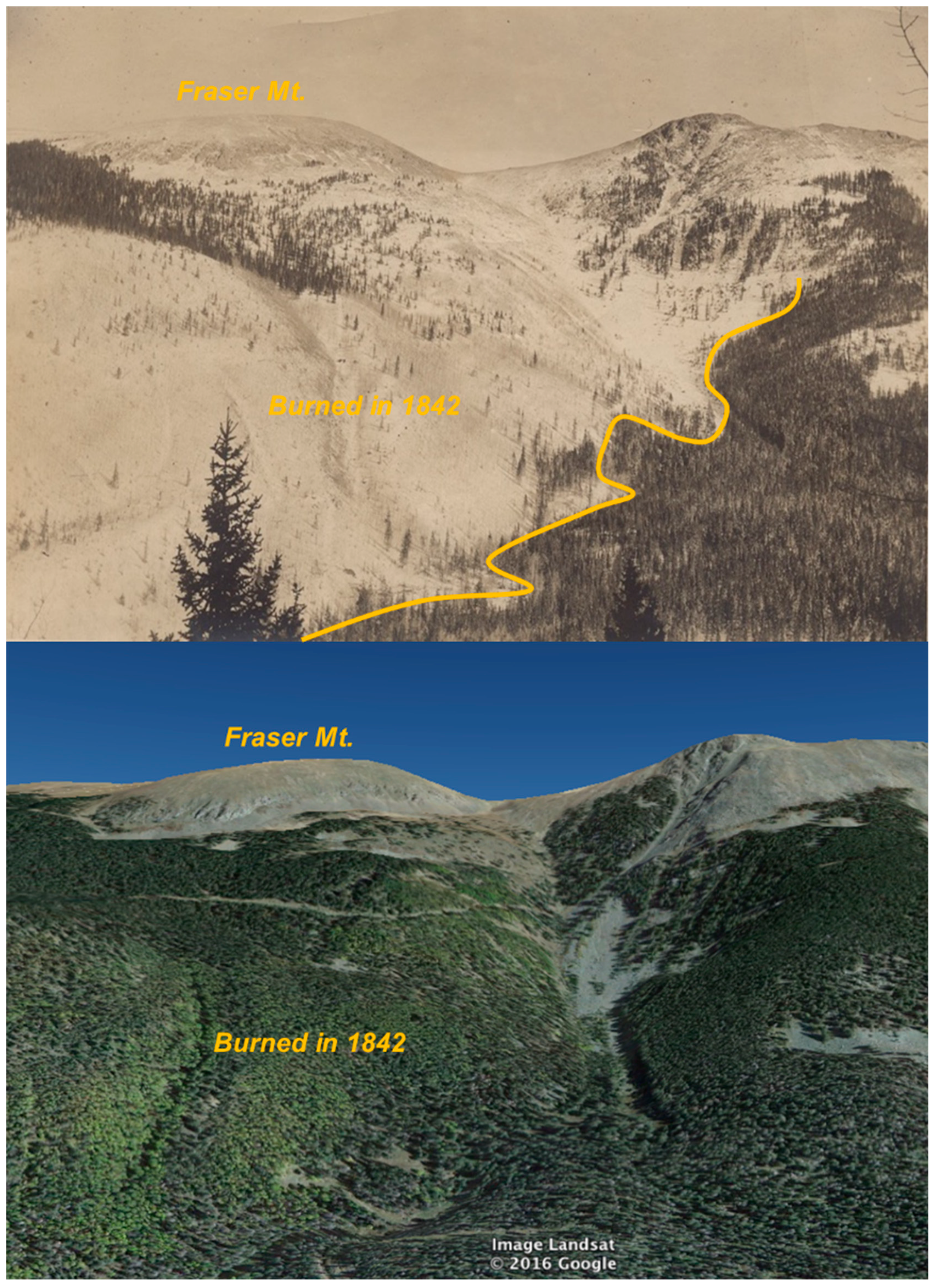
Figure 9.
Repeat images looking east from 1903 (top) and 2016 (bottom) of the upper Rio Hondo drainage that burned in a high-severity fire in 1842. The visible burned area includes age-structure plot RHD. The sketched burn boundary line (top) is estimated to be the southern-most extent of this high-severity fire patch (See Figure 7). The conifer forest to the south (top photo, bottom right) had trees dating to the 1650s (plot RHG) and did not burn in the 1842 high-severity patch. Fraser Mountain is the dome at image left. The historical image is courtesy of Mickey Blake and Taos Ski Valley Inc., Image no. TSV-1042A. The 2016 image was from Google Earth. See Figure 7 for the photo location and direction.

Figure 10.
Repeat photographs looking southeast from 1903 (top) and 2016 (bottom) of the upper Rio Hondo watershed that burned in a high-severity fire in 1842. The visible burned area includes forest-age plots RHD, E, and F and was taken near plot RHK. Today, the valley is home to Taos Ski Valley and the associated community. The historical image is courtesy of Mickey Blake and Taos Ski Valley Inc., Image no. TSV-1050A. The 2016 photo was taken by Charles Mogen. See Figure 7 for the photograph location and direction. Figure 9 is a close-up of the southern end of the burned (aspen-covered) area.


Table 1.
The tree-ring fire-scar plot and forest-age plot information for the Taos Valley Watersheds. The fire-scar plots are ordered from north to south.
Table 1.
The tree-ring fire-scar plot and forest-age plot information for the Taos Valley Watersheds. The fire-scar plots are ordered from north to south.
| Watershed | Plot Name | Plot Code | Mean Site Elev. (m) | Aspect | Dated Trees | Ownership |
|---|---|---|---|---|---|---|
| Fire-Scar Plots (Tree Cross Sections) | ||||||
| Rio Hondo | Manzanita Canyon | MAN | 2697 | S | 6 | Carson NF |
| Yerba Canyon | YER | 2716 | S | 10 | Carson NF | |
| Rio Pueblo | La Junta North | LJN | 2690 | S | 11 | Taos Pueblo |
| Middle Rio Pueblo | MRP | 2560 | S | 7 | Taos Pueblo | |
| Upper Pine Flats | UPF | 2594 | S | 8 | Taos Pueblo | |
| Rio Fernando | Pueblo Ridge East | PRE | 2786 | S | 14 | Carson NF |
| Pueblo Ridge Central | PRC | 2622 | S | 4 | Carson NF | |
| Pueblo Ridge West | PRW | 2786 | S | 13 | Carson NF | |
| All Sites | — | 2697 | — | 73 | — | |
| Forest-Age Plots (Tree Increment Cores) | ||||||
| Rio Hondo | Forest-age plot A | RHA | 3053 | S | 5 | Carson NF |
| Forest-age plot B | RHB | 3060 | S | 6 | Carson NF | |
| Forest-age plot C | RHC | 3194 | S | 5 | Carson NF | |
| Forest-age plot D | RHD | 3130 | W | 5 | Carson NF | |
| Forest-age plot E | RHE† | 3005 | W | 1 | Pattison Land Trust | |
| Forest-age plot F | RHF | 3105 | W | 6 | Carson NF | |
| Forest-age plot G | RHG | 3170 | W | 8 | Carson NF | |
| Forest-age plot H | RHH | 2844 | N | 4 | Taos Ski Valley | |
| Forest-age plot I | RHI | 3289 | E | 8 | Taos Ski Valley | |
| Forest-age plot J | RHJ | 3126 | E | 8 | Taos Ski Valley | |
| Forest-age plot K | RHK | 3154 | S | 5 | Carson NF | |
| All plots | — | 3103 | — | 61 | — | |
Note: NF = National Forest. † The full aspen cross section cut by R. Pattison from a representative overstory tree. All fire-scar plots were in the ponderosa pine and dry mixed-conifer forest. All forest-age plots were in the subalpine quaking aspen forest, except RHG (spruce-fir), RHI, and RHJ (aspen/mixed-conifer).
Table 2.
The plot composite fire interval statistics (years) during the common period 1600–1899. The plots are ordered from north to south. See Table 1 for the plot names.
Table 2.
The plot composite fire interval statistics (years) during the common period 1600–1899. The plots are ordered from north to south. See Table 1 for the plot names.
| Plot Code | Fires | Mean Fire Interval | Median Fire Interval | Min Interval | Max Interval |
|---|---|---|---|---|---|
| MAN | 6 | 20.8 | 16 | 7 | 51 |
| YER | 8 | 39.3 | 29 | 12 | 74 |
| LJN | 15 | 18 | 14 | 4 | 54 |
| MRP | 22 | 11.3 | 9 | 1 | 34 |
| UPF | 6 | 20.8 | 14 | 13 | 47 |
| PRE | 15 | 16.9 | 14 | 2 | 52 |
| PRC * | 5 | 20.3 | 21.5 | 8 | 30 |
| PRW | 23 | 11.3 | 10 | 2 | 29 |
* The fire interval statistics at PRC were calculated from 1780 to 1899 because of a low sample depth prior to 1780.
Table 3.
The fire interval statistics for fires that burned one or more plots in the Taos Valley Watersheds (1600–1899).
Table 3.
The fire interval statistics for fires that burned one or more plots in the Taos Valley Watersheds (1600–1899).
| Number of Plots Burned (≥) | Fires (#) | Mean | Fire Interval (yrs) | Max | |
|---|---|---|---|---|---|
| Median | Min | ||||
| 1 | 62 | 4.8 | 4 | 1 | 13 |
| 2 | 22 | 12.0 | 11 | 3 | 23 |
| 3 | 10 | 23.8 | 21 | 4 | 72 |
| 4 | 6 | 35.6 | 23 | 8 | 86 |
Table 4.
The upper-elevation forest-age plot maximum trees ages for the upper Rio Hondo watershed. The time since fire was calculated from 2018.
Table 4.
The upper-elevation forest-age plot maximum trees ages for the upper Rio Hondo watershed. The time since fire was calculated from 2018.
| Plot Code | Oldest Tree-Ring Date | Time Since Fire (yrs) |
|---|---|---|
| RHA | 1846 * | 176 |
| RHB | 1854 | 164 |
| RHC | 1896 | 122 |
| RHD | 1846 * | 176 |
| RHE † | 1842 * | 176 |
| RHF | 1845 * | 176 |
| RHG | 1652 | 366 |
| RHH | 1786 | 232 |
| RHI | 1865 | 153 |
| RHJ | 1794 | 224 |
| RHK | 1842 * | 175 |
* Plots located within the 1842 high-severity fire patch; † A single aspen cross section cut by R. Pattison from a representative overstory tree.
© 2019 by the authors. Licensee MDPI, Basel, Switzerland. This article is an open access article distributed under the terms and conditions of the Creative Commons Attribution (CC BY) license (http://creativecommons.org/licenses/by/4.0/).
Share and Cite
MDPI and ACS Style
Johnson, L.B.; Margolis, E.Q. Surface Fire to Crown Fire: Fire History in the Taos Valley Watersheds, New Mexico, USA. Fire 2019, 2, 14. https://doi.org/10.3390/fire2010014
AMA Style
Johnson LB, Margolis EQ. Surface Fire to Crown Fire: Fire History in the Taos Valley Watersheds, New Mexico, USA. Fire. 2019; 2(1):14. https://doi.org/10.3390/fire2010014
Chicago/Turabian StyleJohnson, Lane B., and Ellis Q. Margolis. 2019. "Surface Fire to Crown Fire: Fire History in the Taos Valley Watersheds, New Mexico, USA" Fire 2, no. 1: 14. https://doi.org/10.3390/fire2010014