Next Issue
Volume 2, June
Previous Issue
Volume 1, December


Fire, Volume 2, Issue 1 (March 2019) – 16 articles

Cover Story (view full-size image): 
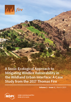
On 16 December 2017, the Thomas Fire roared down San Ysidro Canyon in Montecito, CA, fanned by 60+ mph winds and the extreme drought. Looking west across the canyon in April 2018, the effects of pre-fire fuel reduction efforts are evident. The massive fire consumed dense chaparral at such a high intensity that the fire-tolerant plants are not yet re-sprouting in the right side of the photo. However, thinning and defensible space around the white house, depicted here, and the historic San Ysidro Ranch, just below, starved the fire of fuel, bringing it to the ground. This transition is evident from the lush green grass—vegetation that is critical to stabilizing the soil and minimizing post-fire landslides—growing back just four months after the fire. The work was done as part of a community-wide effort to reduce wildfire vulnerability, saving Montecito on what could have otherwise been the day the town [...] Read more.
  • Issues are regarded as officially published after their release is announced to the table of contents alert mailing list.
  • You may sign up for e-mail alerts to receive table of contents of newly released issues.
  • PDF is the official format for papers published in both, html and pdf forms. To view the papers in pdf format, click on the "PDF Full-text" link, and use the free Adobe Reader to open them.
Order results
Result details
Section
Select all
Export citation of selected articles as:
4 pages, 168 KiB  
Reply
Reply to Ruby, B. Comment on Collins, C.N., et al. Body Composition Changes of United States Smokejumpers during the 2017 Fire Season. Fire. 2018, 1, 48. Fire 2019, 2, 15
by Randall H. Brooks
Fire 2019, 2(1), 16; https://doi.org/10.3390/fire2010016 - 20 Mar 2019
Viewed by 2282
4 pages, 165 KiB  
Comment
Comment on Collins, C.N.; et al. Body Composition Changes of United States Smokejumpers during the 2017 Fire Season. Fire 2018, 1, 48
by Brent C. Ruby
Fire 2019, 2(1), 15; https://doi.org/10.3390/fire2010015 - 20 Mar 2019
Cited by 1 | Viewed by 2116
Abstract
In the recent manuscript by Collins et al [...] Full article
21 pages, 5217 KiB  
Article
Surface Fire to Crown Fire: Fire History in the Taos Valley Watersheds, New Mexico, USA
by Lane B. Johnson and Ellis Q. Margolis
Fire 2019, 2(1), 14; https://doi.org/10.3390/fire2010014 - 14 Mar 2019
Cited by 4 | Viewed by 4969
Abstract
Tree-ring fire scars, tree ages, historical photographs, and historical surveys indicate that, for centuries, fire played different ecological roles across gradients of elevation, forest, and fire regimes in the Taos Valley Watersheds. Historical fire regimes collapsed across the three watersheds by 1899, leaving [...] Read more.
Tree-ring fire scars, tree ages, historical photographs, and historical surveys indicate that, for centuries, fire played different ecological roles across gradients of elevation, forest, and fire regimes in the Taos Valley Watersheds. Historical fire regimes collapsed across the three watersheds by 1899, leaving all sites without fire for at least 119 years. Historical photographs and quaking aspen (Populus tremuloides Michx.) ages indicate that a high-severity fire historically burned at multiple high-elevation subalpine plots in today’s Village of Taos Ski Valley, with large high-severity patches (>640 ha). Low-severity, frequent (9–29-year median interval) surface fires burned on the south aspects in nearby lower elevation dry conifer forests in all watersheds. Fires were associated with drought during the fire year. Widespread fires commonly burned synchronously in multiple watersheds during more severe drought years, preceded by wet years, including fire in all three watersheds in 1664, 1715, and 1842. In contrast, recent local “large” wildfires have only burned within single watersheds and may not be considered large in a historical context. Management to promote repeated low-severity fires and the associated open stand structures is within the historical range of variability in the dry conifer forests of these watersheds. In the high-elevation, subalpine forests, different management approaches are needed, which balance ecological and socioeconomic values while providing public safety. Full article
Show Figures

Figure 1

17 pages, 1837 KiB  
Article
Preparedness and Experiences of Evacuees from the 2016 Fort McMurray Horse River Wildfire
by Tara K. McGee
Fire 2019, 2(1), 13; https://doi.org/10.3390/fire2010013 - 6 Mar 2019
Cited by 20 | Viewed by 5720
Abstract
The 2016 Fort McMurray Horse River Wildfire that caused the evacuation of more than 88,000 residents from the Regional Municipality of Wood Buffalo (RMWB), Alberta is the largest wildfire evacuation in Canadian history. This paper presents results of an online survey of 447 [...] Read more.
The 2016 Fort McMurray Horse River Wildfire that caused the evacuation of more than 88,000 residents from the Regional Municipality of Wood Buffalo (RMWB), Alberta is the largest wildfire evacuation in Canadian history. This paper presents results of an online survey of 447 evacuees in June when some residents had returned to RMWB, and others were still living elsewhere. Results of this online survey show that many survey respondents were not aware of the high wildfire risk leading up to May 3rd and social cues indicated they should carry on as usual. Many respondents received little if any warning time to enable them to prepare. Most respondents had a vehicle, but traffic impediments caused some to run out of gas, food and water on the drive away from Fort McMurray. Most respondents stayed in more than one location, with most staying with friends and family for at least part of the evacuation. Some respondents faced challenges including financial difficulties, finding suitable accommodation, and dealing with insurance, and some received insufficient information. Help was offered to evacuees by a vast array of sources including organizations, businesses, communities, and residents. The results of this study show that most survey respondents were not prepared before they had to leave, which increased reliance on help provided by others. Full article
Show Figures

Figure 1

14 pages, 987 KiB  
Technical Note
A Device for Instantaneously Estimating Duff Moisture Content Is also Effective for Grassland Fuels
by Devan Allen McGranahan
Fire 2019, 2(1), 12; https://doi.org/10.3390/fire2010012 - 27 Feb 2019
Cited by 2 | Viewed by 2936
Abstract
Fine-fuel moisture is an important variable in the wildland fire environment, but measuring live fuel moisture is time-consuming. There is a strong incentive to develop technologies that provide instantaneous measurements of fine-fuel moisture. Campbell Scientific, Inc. markets a device that uses dielectric permittivity [...] Read more.
Fine-fuel moisture is an important variable in the wildland fire environment, but measuring live fuel moisture is time-consuming. There is a strong incentive to develop technologies that provide instantaneous measurements of fine-fuel moisture. Campbell Scientific, Inc. markets a device that uses dielectric permittivity to measure the moisture content of duff fuels in forests; this Duff Moisture Meter (DMM600) might also be applied to herbaceous grassland fuels but its effectiveness has not been tested. This paper describes how grassland fuel samples collected for the DMM600 do well to represent the broader fuelbed, and that the dielectric permittivity values of the DMM600 correlate well with the actual moisture content of uncured grassland fuels. Results suggest the DMM600 can effectively estimate moisture content in uncured grassland fuels, including the overall fuelbed as well as live herbaceous fuels and well-aggregated samples of the grassland litter layer. Calibration equations and tips to ensure representative data are provided. Full article
Show Figures

Figure 1

14 pages, 3105 KiB  
Article
Fire Risk Assessment of Combustible Exterior Cladding Using a Collective Numerical Database
by Timothy Bo Yuan Chen, Anthony Chun Yin Yuen, Guan Heng Yeoh, Wei Yang and Qing Nian Chan
Fire 2019, 2(1), 11; https://doi.org/10.3390/fire2010011 - 25 Feb 2019
Cited by 44 | Viewed by 9707
Abstract
Recent high-profile building fires involving highly-combustible external cladding panels in Australia as well as Dubai, China, and the United Kingdom have created a heightened awareness by the public, government, and commercial entities to act on the risks associated with non-compliant building structures. In [...] Read more.
Recent high-profile building fires involving highly-combustible external cladding panels in Australia as well as Dubai, China, and the United Kingdom have created a heightened awareness by the public, government, and commercial entities to act on the risks associated with non-compliant building structures. In this paper, a database of fire events involving combustible aluminium composite panels was developed based on (i) review of relevant major fire events in Australia and other countries, and (ii) numerical simulation of the ignitability, fire spread, and toxic emissions associated with composite panels. Through the application of large-eddy-simulation (LES)-based computational fire field models, the associated risks for a standardized two-storey building with external cladding was considered in this study. A total of sixteen simulation cases with different initial sizes of the fire and different air cavity widths in the exterior cladding assembly were examined to investigate the tolerable situations and their influences. It was discovered that for most cases, with an initial fire size greater than 400 kW/m−2, the fire will spread from the first to second floor before the allowed egress time period. Full article
Show Figures

Figure 1

22 pages, 5498 KiB  
Article
Assessing the Relationship between Forest Structure and Fire Severity on the North Rim of the Grand Canyon
by Valentijn Hoff, Eric Rowell, Casey Teske, LLoyd Queen and Tim Wallace
Fire 2019, 2(1), 10; https://doi.org/10.3390/fire2010010 - 21 Feb 2019
Cited by 9 | Viewed by 4308
Abstract
While operational fire severity products inform fire management decisions in Grand Canyon National Park (GRCA), managers have expressed the need for better quantification of the consequences of severity, specifically forest structure. In this study we computed metrics related to the forest structure from [...] Read more.
While operational fire severity products inform fire management decisions in Grand Canyon National Park (GRCA), managers have expressed the need for better quantification of the consequences of severity, specifically forest structure. In this study we computed metrics related to the forest structure from airborne laser scanning (ALS) data and investigated the influence that fires that burned in the decade previous had on forest structure on the North Rim of the Grand Canyon in Arizona. We found that fire severity best explains the occurrence of structure classes that include canopy cover, vertical fuel distribution, and surface roughness. In general we found that high fire severity resulted in structure types that exhibit lower canopy cover and higher surface roughness. Areas that burned more frequently with lower fire severity in general had a more closed canopy and a lower surface roughness, with less brush and less conifer regeneration. In a random forests modeling exercise to examine the relationship between severity and structure we found mean canopy height to be a powerful explanatory variable, but still proved less informative than the three-component structure classification. We show that fire severity not only impacts forest structure but also brings heterogeneity to vegetation types along the elevation gradient on the Kaibab plateau. This work provides managers with a unique dataset, usable in conjunction with vegetation, fuels and fire history data, to support management decisions at GRCA. Full article
Show Figures

Figure 1

19 pages, 6374 KiB  
Case Report
A Socio-Ecological Approach to Mitigating Wildfire Vulnerability in the Wildland Urban Interface: A Case Study from the 2017 Thomas Fire
by Crystal A. Kolden and Carol Henson
Fire 2019, 2(1), 9; https://doi.org/10.3390/fire2010009 - 11 Feb 2019
Cited by 38 | Viewed by 15906
Abstract
Wildfire disasters are one of the many consequences of increasing wildfire activities globally, and much effort has been made to identify strategies and actions for reducing human vulnerability to wildfire. While many individual homeowners and communities have enacted such strategies, the number subjected [...] Read more.
Wildfire disasters are one of the many consequences of increasing wildfire activities globally, and much effort has been made to identify strategies and actions for reducing human vulnerability to wildfire. While many individual homeowners and communities have enacted such strategies, the number subjected to a subsequent wildfire is considerably lower. Furthermore, there has been limited documentation on how mitigation strategies impact wildfire outcomes across the socio-ecological spectrum. Here we present a case report documenting wildfire vulnerability mitigation strategies undertaken by the community of Montecito, California, and how such strategies addressed exposure, sensitivity, and adaptive capacity. We utilize geospatial data, recorded interviews, and program documentation to synthesize how those strategies subsequently impacted the advance of the 2017 Thomas Fire on the community of Montecito under extreme fire danger conditions. Despite the extreme wind conditions and interviewee estimates of potentially hundreds of homes being consumed, only seven primary residences were destroyed by the Thomas Fire, and firefighters indicated that pre-fire mitigation activities played a clear, central role in the outcomes observed. This supports prior findings that community partnerships between agencies and citizens are critical for identifying and implementing place-based solutions to reducing wildfire vulnerability. Full article
Show Figures

Figure 1

4 pages, 219 KiB  
Comment
Correspondence: Uncertainty in Climate-Vegetation Feedbacks on Fire Regimes Challenges Reliable Long-Term Projections of Burnt Area from Correlative Models
by Lluís Brotons and Andrea Duane
Fire 2019, 2(1), 8; https://doi.org/10.3390/fire2010008 - 5 Feb 2019
Cited by 6 | Viewed by 3037
Abstract
Recent studies have explored the use of simple correlative models to project changes in future burnt areas (BAs) around the globe. However, estimates of future fire danger suffer from the critical shortcoming that feedbacks on climate change effects on vegetation are not explicitly [...] Read more.
Recent studies have explored the use of simple correlative models to project changes in future burnt areas (BAs) around the globe. However, estimates of future fire danger suffer from the critical shortcoming that feedbacks on climate change effects on vegetation are not explicitly included in purely correlative approaches causing potential major unknown biases on BA projections. In a recent application of this approach led by Marco Turco and co-workers in the journal Nature Communications (doi:10.1038/s41467-018-06358-z), a simple correlative model was used to project an increase in future burnt areas for the Mediterranean region. The authors related BAs to regional estimates of cumulative drought surrogates, and later used this relationship to infer changes derived from future climate data. To account for negative climate-vegetation feedback on fire regimes, they used regional variability in the BA–drought relationship. The main assumption behind the approach used was that fire–drought relationships currently measured under a given productivity gradient (i.e., sensitivity of fire activity to dry periods is stronger in cooler/productive sites) can be consistently used to infer new relationships arising in the future. While representing a step forward in acknowledging the pitfalls of current projections of BAs, this short-cut falls short in allowing to account for the key process behind climate–vegetation-fire feedbacks. We argue that a series of mechanisms, ranging from the dynamic nature of fire–drought relationships to the human influences they experience, do not ensure that these relationships are to be maintained in the future with major, overall still unknown, consequences on future fire danger projections. Resolving this challenge will greatly benefit from the development of mechanistic approaches that explicitly consider the processes by which vegetation changes derived from climate influence fire regimes. Full article
18 pages, 6800 KiB  
Article
Natural Ventilated Smoke Control Simulation Case Study Using Different Settings of Smoke Vents and Curtains in a Large Atrium
by Anthony Chun Yin Yuen, Timothy Bo Yuan Chen, Wei Yang, Cheng Wang, Ao Li, Guan Heng Yeoh, Qing Nian Chan and Ming Chung Chan
Fire 2019, 2(1), 7; https://doi.org/10.3390/fire2010007 - 30 Jan 2019
Cited by 20 | Viewed by 5628
Abstract
In this study, a Large Eddy Simulation (LES) based fire field model was applied to numerically investigate the effectiveness of smoke control using smoke vents and curtains within a large-scale atrium fire. Two compartment configurations were considered: the first case with no smoke [...] Read more.
In this study, a Large Eddy Simulation (LES) based fire field model was applied to numerically investigate the effectiveness of smoke control using smoke vents and curtains within a large-scale atrium fire. Two compartment configurations were considered: the first case with no smoke curtains installed, while the second case included a smoke curtain at the centre of the compartment to trap smoke. Based on the thermocouple results, it was found that the model predicted the gas temperature near the fire particularly well. The time development and heat transfer of the gas temperature predictions were in good agreement with the experimental measurements. Nevertheless, the gas temperature was slightly under-predicted when the thermocouple was further away from the flaming region. Overall, it was discovered that the combination of a smoke curtain and ceiling vents was a highly effective natural smoke exhaust system. However, under the same vent configuration, if the smoke curtain height is not adequate to completely block the spread of smoke, it significantly reduces the pressure differential between the compartment and the exterior, causing reduced flow rates in the outlet vents. Full article
Show Figures

Figure 1

8 pages, 2746 KiB  
Article
Flame Temperatures Saturate with Increasing Dead Material in Ulex europaeus, but Flame Duration, Fuel Consumption and Overall Flammability Continue to Increase
by Jennifer M. Dent, Hannah L. Buckley, Audrey Lustig and Timothy J. Curran
Fire 2019, 2(1), 6; https://doi.org/10.3390/fire2010006 - 29 Jan 2019
Cited by 7 | Viewed by 4395
Abstract
A key determinant of wildfire behaviour is the flammability of constituent plants. One plant trait that influences flammability is the retention of dead biomass, as the low moisture content of dead material means less energy is required to achieve combustion. However, the effect [...] Read more.
A key determinant of wildfire behaviour is the flammability of constituent plants. One plant trait that influences flammability is the retention of dead biomass, as the low moisture content of dead material means less energy is required to achieve combustion. However, the effect of the dead-to-live ratio of fuel on plant flammability has rarely been experimentally quantified. Here we examine the nature of the relationship between dead fuel accumulation and flammability in Ulex europaeus (common gorse). Shoots with varying proportions of dead material were ignited in a purpose-built plant-burner. Three components of flammability were measured: sustainability (flame duration), consumability (proportion burnt biomass) and combustibility (maximum temperature). While flame duration and proportion burnt biomass had a positive linear relationship with the proportion of dead material, the response of maximum temperature was positive but non-linear. All three flammability components were reduced to a single variable using principal components analysis; this had a non-linear relationship with the proportion of dead material. The response of maximum temperature to dead material plateaued at 39%. These findings have implications for the management of habitats invaded by gorse; to mitigate fire hazard associated with gorse, stands should be kept at a relatively young age when dead fuel is less prevalent. Full article
Show Figures

Figure 1

2 pages, 120 KiB  
Editorial
Acknowledgement to Reviewers of Fire in 2018
by Fire Editorial Office
Fire 2019, 2(1), 5; https://doi.org/10.3390/fire2010005 - 8 Jan 2019
Viewed by 1916
Abstract
Rigorous peer-review is the corner-stone of high-quality academic publishing [...] Full article
24 pages, 5286 KiB  
Technical Note
Modelling of the Radiant Heat Flux and Rate of Spread of Wildfire within the Urban Environment
by Greg Penney and Steven Richardson
Fire 2019, 2(1), 4; https://doi.org/10.3390/fire2010004 - 7 Jan 2019
Cited by 9 | Viewed by 7478
Abstract
One approach to increase community resilience to wildfire impacts is the enhancement of residential construction standards in an effort to provide protective shelters for families within their own homes. Current wildfire models reviewed in this study assume fire growth is unrestricted by vegetation [...] Read more.
One approach to increase community resilience to wildfire impacts is the enhancement of residential construction standards in an effort to provide protective shelters for families within their own homes. Current wildfire models reviewed in this study assume fire growth is unrestricted by vegetation fuel bed geometry; the head fire has attained a quasi-steady rate of spread; and the shielding effects of urban development are ignored. As a result, radiant heat flux may be significantly overestimated for small vegetation fires in road reserves, urban parklands, and similar scenarios. This paper proposes two new models to address this issue, and utilises two case studies for comparison against existing approaches. The findings are significant as this is the first study to analyse these factors from a fire engineering perspective, and to demonstrate that the use of landscape scale or siege wildfire models may not be appropriate within the urban context. The development of enhanced wildfire models will have a significant impact on town planning and construction practices in areas prone to wildfires, as well as firefighting suppression efforts when these events occur. Full article
Show Figures

Figure 1

12 pages, 1729 KiB  
Article
Calculation of Critical Water Flow Rates for Wildfire Suppression
by Greg Penney, Daryoush Habibi, Marcus Cattani and Murray Carter
Fire 2019, 2(1), 3; https://doi.org/10.3390/fire2010003 - 3 Jan 2019
Cited by 13 | Viewed by 5384
Abstract
Predicting water suppression requirements and its impacts on firefighting strategies and logistics within the urban environment has been the subject of many previous studies, however the same level of research has yet to be applied in the realm of wildfire suppression. To work [...] Read more.
Predicting water suppression requirements and its impacts on firefighting strategies and logistics within the urban environment has been the subject of many previous studies, however the same level of research has yet to be applied in the realm of wildfire suppression. To work towards addressing this knowledge gap, this paper provides guidance for Incident Controllers in relation to critical water flow rates required to extinguish large wildfire across a wide range of forest fuel loads, fire weather and active fire front depths. This is achieved through mathematical empirical analysis of water flow rates required for head fire suppression during 540 simulated wildfires in forest vegetation. This research applies a fire engineering approach to wildfire suppression logistics and deterministically assess the suitability of appliance and aircraft based head fire suppression. The results highlight the limitations of offensive wildfire suppression involving direct head fire attacks by appliances once wildfires attain a quasi-steady state in forest fuels. Full article
Show Figures

Figure 1

18 pages, 631 KiB  
Article
Moisture Sorption Models for Fuel Beds of Standing Dead Grass in Alaska
by Eric A. Miller
Fire 2019, 2(1), 2; https://doi.org/10.3390/fire2010002 - 23 Dec 2018
Cited by 7 | Viewed by 2970
Abstract
Sorption models were developed to predict the moisture content in fuelbeds of standing dead grass from ambient weather measurements. Intuition suggests that the response time of standing dead grass to diurnal changes in weather is negligible and that moisture content tracks the equilibrium [...] Read more.
Sorption models were developed to predict the moisture content in fuelbeds of standing dead grass from ambient weather measurements. Intuition suggests that the response time of standing dead grass to diurnal changes in weather is negligible and that moisture content tracks the equilibrium moisture content under most field conditions. This assumption suggests that moisture content could be modelled by empirically fitting coefficients to equations of equilibrium moisture content using field measurements. Here, six equations commonly used in wildland fire management and other industries were fit using 293 measurements of weather and moisture content in standing dead grass from Alaska, U.S.A. Predictors were air temperature and either relative humidity or dewpoint depression. Mean absolute errors of the best three models were approximately 1.16% of moisture content. The models predicted well the moisture content of an independently collected dataset from Canada but less so a set from Australia. The models may be used in wildland fire danger rating and fire behavior prediction systems. Full article
Show Figures

Figure 1

17 pages, 3634 KiB  
Article
Fire Recurrence and Normalized Difference Vegetation Index (NDVI) Dynamics in Brazilian Savanna
by Níckolas Castro Santana
Fire 2019, 2(1), 1; https://doi.org/10.3390/fire2010001 - 21 Dec 2018
Cited by 4 | Viewed by 6384
Abstract
Fire is one of the main modeling agents of savanna ecosystems, affecting their distribution, physiognomy and species diversity. Changes in the natural fire regime on savannas cause disturbances in the structural characteristics of vegetation. Theses disturbances can be effectively monitored by time series [...] Read more.
Fire is one of the main modeling agents of savanna ecosystems, affecting their distribution, physiognomy and species diversity. Changes in the natural fire regime on savannas cause disturbances in the structural characteristics of vegetation. Theses disturbances can be effectively monitored by time series of remote sensing data in different terrestrial ecosystems such as savannas. This study used trend analysis in NDVI (Normalized Difference Vegetation Index)–MODIS (Moderate Resolution Imaging Spectroradiometer) time series to evaluate the influence of different fire recurrences on vegetation phenology of the Brazilian savanna in the period from 2001 to 2016. The trend analysis indicated several factors responsible for changes in vegetation: (a) The absence of fire in savanna phytophysiognomies causes a constant increase in MODIS–NDVI, ranging from 0.001 to 0.002 per year, the moderate presence of fire in these areas does not cause significant changes, while the high recurrence results in decreases of MODIS–NDVI, ranging from −0.002 to −0.008 per year; (b) Forest areas showed a high decrease in NDVI, reaching up to −0.009 MODIS–NDVI per year, but not related to fire recurrence, indicating the high degradation of these phytophysiognomies; (c) Changes in vegetation are highly connected to the protection status of the area, such as areas of integral protection or sustainable use, and consequently their conservation status. Areas with greater vegetation conservation had more than 70% of positive changes in pixels with significant tendencies. Absence or presence of fire are the main agents of vegetation change in areas with lower anthropic influence. These results reinforce the need for a suitable fire management policy for the different types of Cerrado phytophysiognomies, in addition to highlighting the efficiency of remote sensing time series for evaluation of vegetation phenology. Full article
Show Figures

Figure 1

Previous Issue
Next Issue
Back to TopTop