Article

Hazard Analysis and Vulnerability Assessment of Cultural Landscapes Exposed to Climate Change-Related Extreme Events: A Case Study of Wachau (Austria)

1
National Research Council of Italy, Institute of Atmospheric Science and Climate, 40129 Bologna, Italy
2
Department of Environmental and Prevention Sciences, University of Ferrara, 44121 Ferrara, Italy
3
Vocational Training School for Viticulture and Oenology, Dry Stone Walling School, 3500 Krems, Austria
4
Center for Cultural Property Protection, University for Continuing Education Krems, 3500 Krems, Austria
5
Istituto Superiore per la Protezione e la Ricerca Ambientale, 00144 Roma, Italy
*
Author to whom correspondence should be addressed.
Heritage 2024, 7(4), 1917-1934; https://doi.org/10.3390/heritage7040091
Submission received: 9 January 2024 / Revised: 15 March 2024 / Accepted: 21 March 2024 / Published: 25 March 2024
(This article belongs to the Special Issue Challenges to Heritage Conservation under Climate Change)

Abstract

:
The present paper aims to study the Wachau Valley in Austria as a representative Cultural Landscape under threat from extreme hydrometeorological hazards linked to climate change. The primary objective is to investigate the impacts and assess the vulnerability associated with the events of heavy rain and flooding. The methodology employed consists of an investigation of recorded past events impacting the Wachau; a vulnerability ranking system; a climate time series analysis based on earth observation products; and future hazard maps at territorial level, developed with outputs from regional and global climate models. The investigation we carried out provides a vulnerability assessment of two terraced areas with a surface of about 10,000 m2 in total, characterized by the presence of dry stone walls, with different state of conservation in the Municipality of Krems (Wachau). In addition, climate projections at territorial level for the extreme climate indices R20mm, R95pTOT, and R×5day—selected for investigating the likelihood of increases/decreases in events of heavy rain and large basin flooding—are provided, with a spatial resolution of ~12 km for the near and far future (2021–2050; 2071–2100) under stabilizing (RCP 4.5) and pessimistic (RCP 8.5) scenarios. The results indicate a general increase for the three indices in the studied areas during the far future under the pessimistic scenario, suggesting a heightened risk of heavy rain and flooding. These findings aim to inform policymakers and decision-makers in their development of strategies for safeguarding cultural heritage. Furthermore, they serve to assist local stakeholders in enhancing their understanding of prioritizing interventions related to preparedness, emergency response, and recovery.

1. Introduction

Climate change is widely acknowledged to be posing ongoing and emerging challenges to safeguarding and preserving cultural heritage in its broadest sense. Cultural heritage encompasses resources inherited from the past in various manifestations (tangible and intangible), intended for transmission to future generations. Monumental complexes, archaeological sites, underwater ruins, historical buildings with related collections, landscapes, natural areas, and the entirety of cultural assets are under threat because of the impacts of both slow and extreme climate changes [1,2,3,4,5].
It is foreseen that extreme events such as heavy precipitation, flooding, and drought periods will happen more frequently and with a greater intensity across most land regions, as highlighted in the latest Sixth Assessment Report (AR6) of the Intergovernmental Panel on Climate Change (IPCC) [6]. In particular, the main findings from the contributions of Working Group II regarding hydrometeorological hazards and related impacts in Western and Central Europe (WCE), where Austria is located, are the following: precipitation extremes have increased during recent decades, varying spatially (with medium confidence—level of evidence and agreement); precipitation has increased river flood hazards by 11% per decade from 1960 to 2010; and the most recent three decades had the highest number of floods in the past 500 years, with increases in summer. Moreover, the intensity and frequency of heavy rainfall events is projected to increase in WCE (high confidence); projections indicate a continuation of the observed trend of river flood hazard increases in WCE (high confidence), with increases of 10% at a 2 °C global warming level (GWL) and 18% at 4.4 °C GWL, making Europe one of the regions with the largest projected increase in flood risk. On this basis, without adaptation measures, increases in extreme rainfall will substantially increase direct flood damage; with low adaptation, damage from river flooding is projected to be three times higher at 1.5 °C GWL, four times at 2 °C GWL, and six times at 3 °C GWL [7].
In this context, it is expected that cultural heritage will encounter unprecedented multi-risk scenarios, presenting novel challenges for its protection [8]. Certainly, the effects of extreme climate on cultural heritage are significant, emphasizing the need for additional research and improved methods to assist decision-makers and governmental bodies in developing plans to handle and mitigate the associated risks, as well as to encourage the incorporation of dedicated measures into national disaster risk-reduction plans from a transnational standpoint [9,10].
The present paper is focused on the study of the Wachau Valley in Austria, as an illustrative case of a cultural landscape facing challenges linked to climate change. Cultural landscapes enrich society with their aesthetic values by blending intrinsic natural qualities with inherited cultural elements. Although climate change has been recognized as a threat to cultural landscapes, the extent and quantification of its impacts, as well as their future projections, have to be clarified. It should be noted that most of the existing research focuses on a qualitative assessment and especially on the study of current climate change impacts on cultural landscapes. In fact, the works that attempt to provide quantitative data, and that use high-spatial resolution future projections of extreme climate indices on this type of cultural heritage, are still sporadic [8,11,12,13,14].
Extending over 36 km in length, the Wachau comprises the Danube River Valley, enclosed by steep hilly terrain on both sides. Renowned for its exceptional visual and landscape attributes, it earned the designation of “Wachau Cultural Landscape” on the UNESCO List of World Heritage Sites in December 2000. It displays numerous intact and visible traces of its continuous, organic evolution since prehistoric times, whether in the form of architectural elements (monasteries, castles, ruins), urban planning (towns and villages featuring fundamental layouts dating back to the 11th and 12th centuries), or agricultural practices (primarily focused on cultivating vines and apricot trees) [15,16]. Steep terraces delimited by dry stone walls, mainly used to cultivate vines, are a peculiar feature of the Wachau landscape, and the interest in them has recently been increased due to the inclusion of the “Art of dry-stone walling, knowledge and technique” in UNESCO’s Intangible Cultural Heritage list in 2018 [17].
Generally, terraces have been recognized as an important element—both for the landscape and for their cultural/historical value—and they are considered to be among the most relevant and characteristic anthropological imprints on reliefs [18]. Throughout history, constructing terraces has been regarded as the most effective method for enabling agricultural and forestry activities in mountainous and hilly areas globally. Terraces have facilitated the cultivation of a diverse range of crops, not only expanding productive zones, but also enhancing the quality of landscapes [19]. Terraces are renowned for their importance in preventing landslides, particularly on steep slopes, as their flat areas decrease slope length and gradient, which significantly reduces runoff. Reshaped slopes also contribute to mitigating flooding by creating enlarged catchment areas that intercept rainfall and by delaying runoff [20,21]. Moreover, terraces enhance biodiversity, create favorable microclimatic conditions for agriculture, and serve as effective measures against soil erosion and desertification of the land, as they increase water infiltration [17].
In spite of the unquestionable ecological benefits of terraces, they unfortunately continue to be subjected to abandonment, resulting in a gradual or abrupt deterioration [22].
Most of the existing research and publications focus on the effects of the terraces’ abandonment, so there is still a lack of research involving assessments of the impact of climate change on this type of landscape, as well as risk management to mitigate this impact. Therefore, the present paper aims to enhance knowledge in this field and may represent a starting point for future scientific studies and for setting further steps.
Our specific objectives are hazard analysis at a regional scale in relation to extreme hydrometeorological events (heavy rain and flooding) by using regional climate models and selected extreme indices, and the vulnerability evaluation at a local level of two terraced areas in the Wachau Valley. To do that, the methodological approaches and tools developed within two Interreg Central Europe projects, ProteCHt2save (Risk assessment and sustainable protection of Cultural Heritage in changing environments; 2017–2020) and STRENCH (STRENgthening resilience of Cultural Heritage at risk in a changing environment, 2020–2022), were utilized [23,24]. Consequently, the present contribution has also been useful for testing those methods and developing a series of practical information for the best conservation over time of the assets in question. Results obtained from both hazard and vulnerability evaluations constitute a prerequisite for an adequate risk assessment [2,3,4,9].

2. Materials and Methods

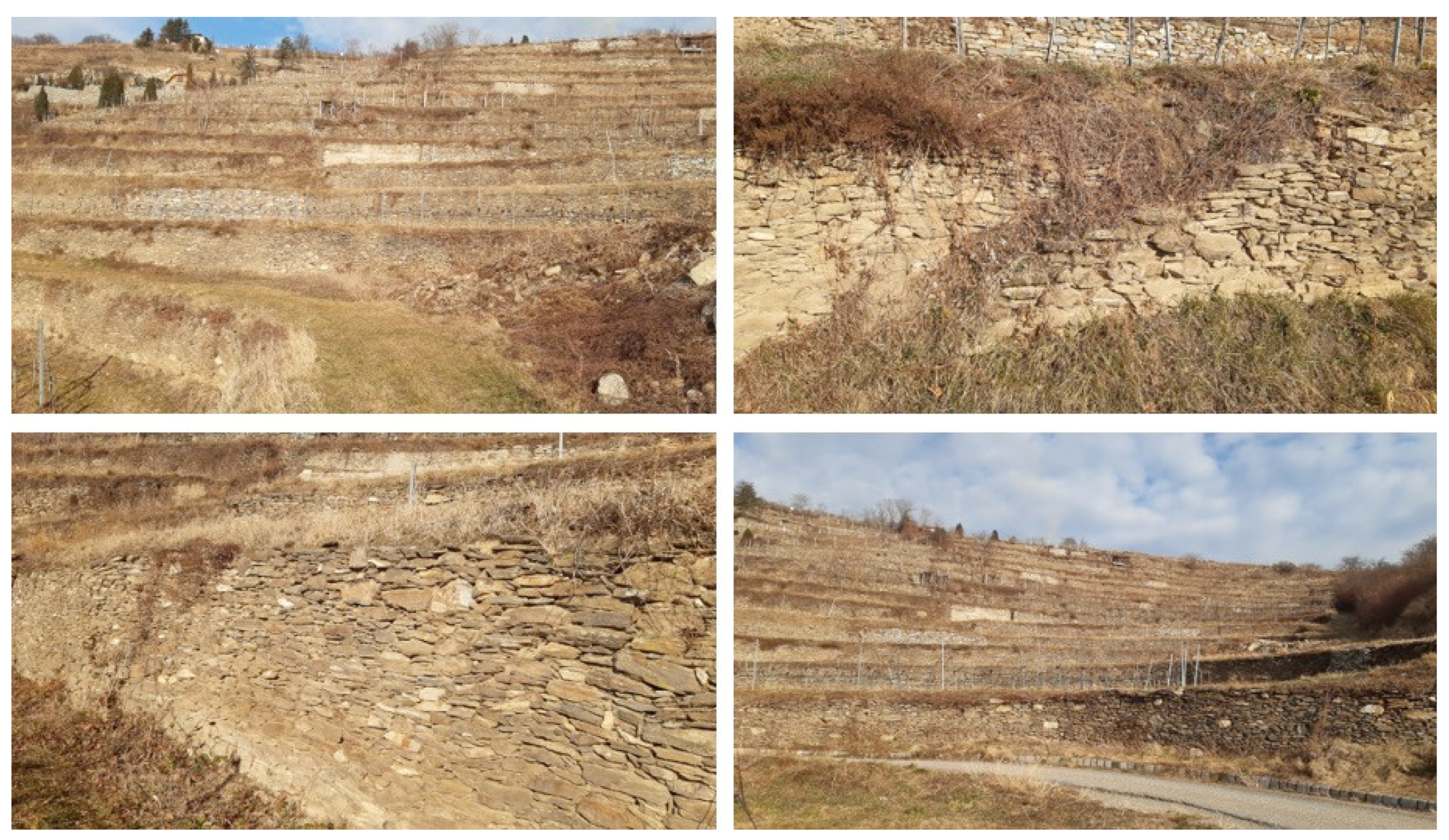
2.1. The Wachau Cultural Landscape and Its Terraces

The Wachau Valley, situated in the Federal Province of Lower Austria at about 80 km west of Vienna, is a UNESCO-listed World Heritage Cultural Landscape that spans 36 km along the Danube River between the towns of Melk and Krems [25] (Figure 1). Designated as the “Wachau Cultural Landscape” in December 2000, it earned recognition for its riverine landscape (UNESCO category ii) and for its medieval landscape (UNESCO category iv), showcasing architectural monuments, human settlements, and agricultural land use [15]. The inscribed property has an area of 18,387 ha, with a buffer zone of 2942 ha [15,25]. The region is regarded as a so-called “Continuing Landscape”, which goes on to be shaped by a culture and the traditional way of life in the region [16]. The Wachau has been inhabited since Paleolithic times and several important artefacts, like sculptures of women found in Stratzing and Willendorf, document the early human habitation that led to continuous development until today. Along the valley historical buildings from Roman times, the Middle Ages, the Renaissance, and the Baroque period can be found.
The area encompasses the Danube River valley and the nearby hills of the southern Waldviertel and Dunkelstein forests. Within the Wachau, the Danube traverses the southern section of the Austrian granite and gneiss highlands, tectonically belonging to the south-eastern marginal zone of the Bohemian Massif, which was formed due to tectonic uplift and river channel incision starting at ca. 5 Ma. The Bohemian Massif is part of the Moldanubian Superunit which consists of medium- to high-grade metamorphic rocks, which were formed during the Variscan Orogeny in the Devonian and Carboniferous, at about 400–300 Ma. Its highest point is the Jauerling peak, reaching 960 m above sea level in the Waldviertel region, while the Dunkelstein Forest, situated on the right bank of the Danube River, attains elevations of up to 725 m above sea level. In contrast, the Danube Valley itself ranges in elevation from 213 m above sea level at Melk to 203 m above sea level at Krems [26].
The Wachau includes examples of terraced landscapes. The first agricultural terraces in the Wachau were created by Bavarian and Salzburgian monks who came to the area and began to cultivate the land, preparing flat areas to plant vineyards [16,26,27]. They protected these terraces against slippage by building a system of dry stone walls, which are part of today’s landscape features. The cultivation of the terraces has suffered over periods of abandonment, starting in the seventeenth century due to labor shortage and continuing with the appearance of phylloxera at the end of the nineteen century. Consequently, most of the vineyards turned to dry grass and shrublands. The viticulture advanced again in the middle of 1950 [16]. Currently, the abandonment is sporadic, and it is mainly due to the younger generation not continuing vine cultivation.

2.2. Methodological Approach

First of all, an analysis of the past calamitous events affecting Wachau was performed based on bibliographic research, through data available in the literature and consultation with local stakeholders, with the aim of gathering information on the areal distribution of the episodes, the damage estimation, and the consecutive interventions by local authorities [9,28,29,30]. This step was fundamental for understanding the major extreme hydrometeorological hazards which the area has been, and is currently, exposed to. Secondly, the Risk Mapping Tool for Cultural Heritage Protection (WGT) platform was applied for (i) the analysis of historic time series of climate extreme indices suitable for investigating past climate extreme events in the Wachau (see method explained in Section 2.2.2 and results reported in Section 3.1); (ii) the assessment of the vulnerability of two terraced areas selected as case studies (see methodology in Section 2.2.1 and results in Section 3.2); (iii) the investigation of future projections of hazards at territorial level covering the Wachau (see Section 2.2.2 for the Methodology and Section 3.3 for Results and Discussion). This platform, developed within the Interreg Central Europe projects ProteCHt2save and STRENCH, was created with the aim of providing a support tool to private and public authorities for the protection and management of cultural heritage sites in Europe at risk from extreme climate events, and it is accessible at https://www.protecht2save-wgt.eu (accessed on 20 December 2023) [31]. The methodological approach we followed is illustrated in Figure 2.

2.2.1. Methodology for Vulnerability Assessment

Following the methodology available in the Risk Mapping Tool for Cultural Heritage Protection (WGT) [31] and applied herein, vulnerability results from the combination of three key factors: susceptibility, exposure, and resilience. Susceptibility “identifies the fragility, deficiency or predisposition of a system to be adversely affected by the occurrence of an event; in other words, it defines the degree to which a cultural heritage asset is affected by an event” [32]. Exposure “refers to the presence of people, livelihoods, species or ecosystems, environmental functions, services, and resources, infrastructure, or economic, social, or cultural assets in places and settings that could be adversely affected by the occurrence of a disaster” [32]. Resilience “identifies the ability of a system to absorb changes without a transition to a different state” [32]. These represent the main elements that need to be characterized for the evaluation of vulnerability and therefore constitute the main requirements. Starting from these requirements, a hierarchy tree is introduced encompassing diverse branches, designated as criteria and sub-criteria. The hierarchy tree was developed by using the MIVES method (Integrated Value Model for Sustainability Assessment) [33] and it is based on Multi-Attribute Utility Theory (MAUT) and the Analytical Hierarchy Process (AHP). The methodology, fully explained by Cacciotti and Drdácký, 2021 [32], basically foresees (i) a first definition of criteria and sub-criteria related to relevant aspects of built and natural heritage vulnerability; (ii) the assignment of weights to each criterion and sub-criterion; (iii) a subsequent adjustment of the previously identified criteria and sub-criteria and their related weights by exploiting the knowledge available in the literature, and an iterative process of consultation with experts and local stakeholders with experience in the management of the sites to be investigated; (iv) the final assignment of a ranking of values for each criterion and sub-criterion. Susceptibility is linked to various physical criteria of the asset, such as the type of materials (whether resistant or prone to degradation); the use (whether continuous or abandoned); the state of conservation at the time of evaluation; and also the environmental and geological context in which the property is inserted, such as the topography of the site and the geomorphological characteristics [34,35,36]. Exposure can be evaluated by considering different criteria focused on the cultural significance of the asset (such as the presence of cultural recognitions or the existence of cultural traditions), while bearing in mind the social and economic dimensions that it constitutes [37,38,39]. Resilience includes preparedness, understood as the existence of risk management plans or warning systems such as alerts by local authorities; whether periodic inspections and regular maintenance are provided; and whether knowledge and awareness are ensured through the involvement of citizens, or through the training of students, the introduction of technical standards, and the sharing of knowledge. Resilience then includes coping capacity, comprising the availability of human and economic resources, the presence of mitigation systems (prevention devices such as drainage ditches), and physical protection (such as barriers for landslides); resilience also includes restorative capacity (the system’s ability to recover after a disaster), which concerns aspects regarding the availability and accessibility of funds for financial recovery or the presence of plans for physical recovery [34,40,41,42].
Vulnerability is finally ranked from 0 ≤ V ≤ 1 (low to high vulnerability) with the following formula [32]:
Vulnerability = (0.70 × Susceptibility) + (0.30 × Exposure) − (0.30 × Resilience)
The ranking of vulnerability is conducted through the active involvement and consultation of local users and stakeholders responsible for the management and maintenance of the cultural site, who are called upon to provide a qualitative estimate of the criteria and sub-criteria associated with each of the three main requirements. By applying this approach and following a guided procedure, available through a specially prepared Excel sheet that can also be used by non-experts in the sector, users can classify the vulnerability of the site under examination. The guided procedure is available in the section “Vulnerability” of the “Risk Mapping Tool for Cultural Heritage Protection” website (https://www.protecht2save-wgt.eu/, accessed on 20 December 2023) and is included in the Supplementary Materials of this paper. The application of this method therefore guarantees a full understanding of the crucial factors that influence vulnerability, encompassing physical, operational, and managerial aspects, having as its ultimate objective the goal of formulating strategies for the protection of cultural heritage against climate change.
For the investigation conducted in the present paper, a selection of two locations of the Wachau region where dry stone walls are in danger from heavy rain was performed, and their vulnerability was ranked thanks to the consultation of local experts in dry stone wall construction. For simplicity and for better distinction, the two terraces have been given the names CH1 and CH2 (Figure 3). Both are terraced vineyards located in the Municipality of Krems, in the buffer zone of the World Heritage Cultural Landscape of Wachau, and are located at about 1 km from the Danube River; CH1 is located in a steeper part, partly based on a scarp, and neighboring a rock slope (Figure 4). It also contains pathways and water channeling elements. CH2 is slightly less steep and is, apart from ramps for small tractors and old small stairways, lacking additional technical elements (Figure 5). The construction of CH1 dates back to 1900–1920, whereas the age of the terraces of CH2 is not known. Over the years, maintenance and some interventions on CH1 and CH2, such as reconstruction and reparation works, have been performed. Detailed site characteristics of CH1 and CH2 are reported in Table 1.

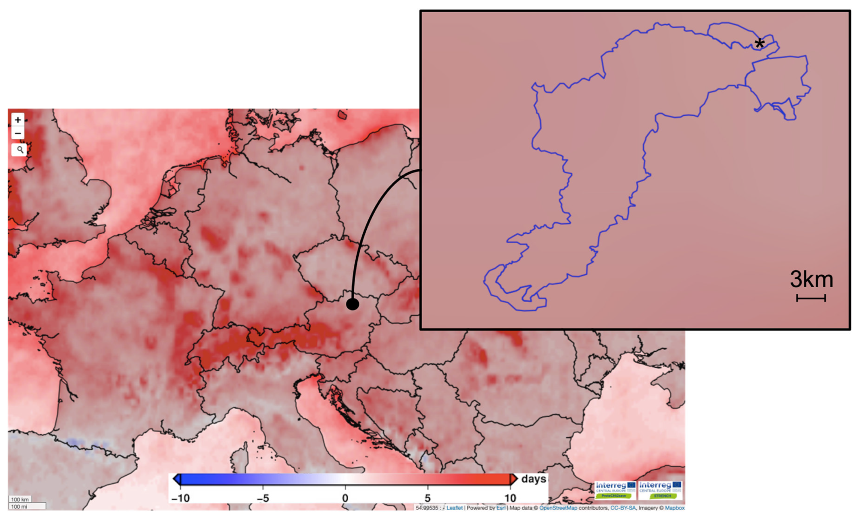
2.2.2. Historic Time Series and Future Projections of Climate Hazards

The Risk Mapping Tool for Cultural Heritage Protection has been used for the elaboration of historic climate time series and the investigation of future projections of hazards at territorial level likely to have an impact on the Wachau area.
First of all, among the climate variables and climate extreme standard indices available in the WGT, a selection of the most appropriate ones has been made for the purpose of our study. The climate extreme indices present in the WGT are defined by the Expert Team on Climate Change Detection Indices (ETCCDI) [4,43,44]. Specifically, in the present study, the ones related to extreme precipitation and flooding events were utilized: R20mm (very heavy precipitation days), R95pTOT (precipitation due to extremely wet days), and R×5day (highest 5-day precipitation amount). The R×5day index in particular has been selected for its known soundness in analyzing the probability of occurrence of large basin floods more likely to be caused by lengthy periods of heavy precipitation over a large region. The selected indices are widely employed for the elaboration of future climate projections at global and regional levels [9,45,46,47].
For the elaboration of the historic climate time series, the “Open Search Tool Box” of the WGT has been used, which enables the exploration of selected climate indices re-computed following the full time series products of Copernicus C3S ERA5 Land (~9 km resolution, from 1981), Copernicus C3S ERA5 (~31 km resolution, from 1981), and NASA GPM IMERG (~10 km resolution, from 2000). The “Open Search Tool Box” provides the possibility to query the database independently, allowing users to select their area of interest directly on the map or by specifying geographic coordinates. Once the point or area of interest is identified, users can choose the climate index and the period they are interested in. Depending on the selections made, the final output may consist of numeric data (e.g., a time series of values from a specific point), a color scale map, or a numerical matrix. All information obtained through the “Open Search Tool Box” are always geocoded. In the current work, it was utilized in order to examine how the picked indices varied over a specific period of time. In particular, time series were exploited in order to understand whether there is a relationship between the extreme indices and the recorded past calamitous events.
For the investigation of future projections of hazards at territorial level, the “Climate Modelling” function of the WGT was utilized, which allows users to download climate hazard maps for the identification of areas in Europe and in the Mediterranean Basin that are susceptible to extreme events associated with climate change.
Specifically, the maps available in the WGT were developed by using 12 different combinations of 6 forcing global models (GCM) driving 5 regional models (RCM). The minimum, mean, and maximum values of the model ensembles were also calculated to overcome the uncertainties of each individual GCM/RCM model. The following future emission scenarios were selected: RCP4.5 (stabilization scenario) and RCP 8.5 (high pathway scenario), outlined in the AR5 Intergovernmental Panel on Climate Change (IPCC) assessment report [48].
For the current study, maps of future changes in R20mm, R×5day, and R95pTOT were investigated (~12 km resolution). The maps show the differences between the periods 2021–2050 and 1976–2005 (near future projection) and between the periods 2071–2100 and 1976–2005 (far future projection), under both RCP 4.5 and 8.5 scenarios.

3. Results and Discussion

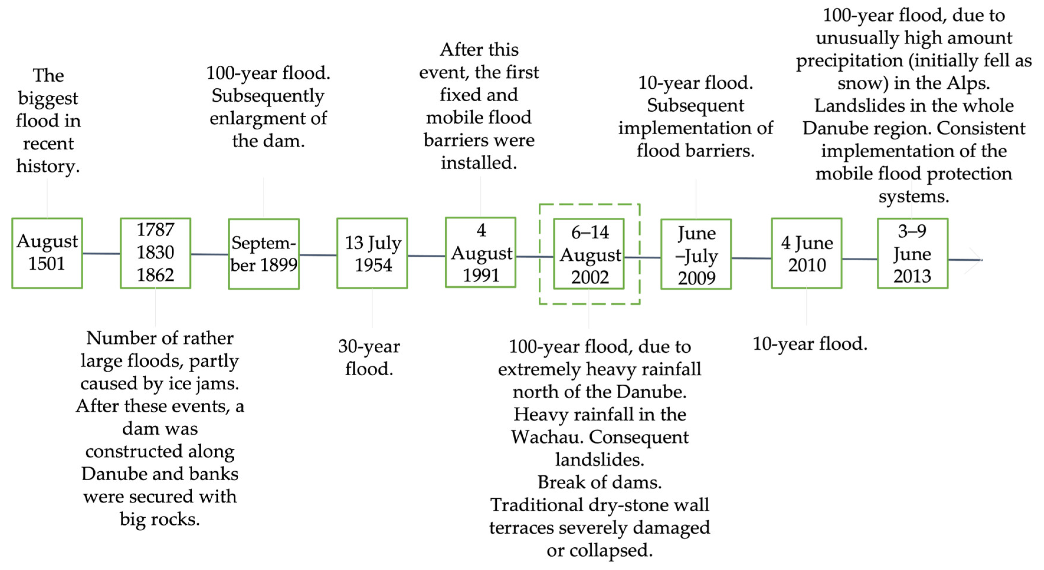
3.1. Past Calamitous Events and Main Criticalities Affecting the Site

What emerged from the bibliographic research and consultation with local stakeholders about past calamitous events is that the main risks posed to the Wachau Cultural Landscape over time occur through flooding from the Danube River and its tributaries, principally due to episodes of extremely heavy rainfall and snowmelt [9,29,30,49]. Figure 6 shows the principal events of flooding in the Wachau Valley from 1500 up to now. A detailed list of all flooding events, with information on damage in the covered area, response actions, and main measures adopted, can be found in Blöschl et al., 2013; Schimek et al., 2020; and Bonazza et al., 2021 [9,29,30]. From the information collected, all the floods reported occurred due to episodes of extremely heavy rainfall and snowmelt in the upper Danube Basin. Following Schimek et al., 2020 [29], during the 100-year flood (a flood that has a 1% chance of occurring in any given year) of 2002, heavy rain was also registered over the Wachau, causing severe damage to 150,000 m2 of traditional dry stone wall wine terraces. In Figure 6 this event is highlighted with a dashed line.
Concerning the examination of historic extremes of precipitation occurring in the area under investigation, the trend over time of the climate extreme indices R20mm and R×5day has been analyzed from 2000 to 2018. Figure 7 and Figure 8, respectively, illustrate the monthly time series of the two indices elaborated for the cities of Krems and Melk (which delimit the Wachau Valley along the Danube) by using historic precipitation data derived from C3S ERA5 Land reanalysis. The graphs clearly show that most of the maximum values of both indices correlate with the most important past events of flooding and heavy rain registered in the area under study. In particular, peaks of R20mm and R×5day related to August 2002 and June 2009 in Figure 7 and Figure 8 are certainly representative of the recorded catastrophic heavy rainfall and floods of the years 2002 and 2009, as listed in Figure 6, showing a higher value in the city of Melk in August 2002. As shown in Figure 7, the record of the flood event that occurred in the area of Wachau in 2013 is better represented by the index R20mm (number of days in a month with precipitation greater than or equal to 20 mm/day) which shows the higher value at the city of Melk compared to Krems in the same year (2013). Analyzing the overall trends, it is evident that not all the peaks present in the graphs of Figure 7 and Figure 8 correspond to the recorded events listed in Figure 6. For a more exhaustive evaluation, an investigation of the indices’ trends at a larger spatial scale including the river basin area would be recommended. Nevertheless, this finding supports the choice of extreme precipitation indexes selected, particularly R20mm and R×5day, for investigating the past and future trends of the considered hydrometeorological hazards.

3.2. Vulnerability Assessment

By applying the methodology described in Section 2.2.1, the final vulnerability values for the two terraced areas under investigation, CH1 and CH2, turned out to be, respectively, 0.11 (with susceptibility equal to 0.15; exposure equal to 0.60; resilience equal to 0.60) and 0.16 (with susceptibility equal to 0.20; exposure equal to 0.60; resilience equal to 0.53). Detailed results obtained for each criterion and sub criterion, thanks to the stakeholders consultation, are reported in Figure 9.
The Excel spreadsheet reporting in detail the multiple choices of value meaning for each criterion and sub-criterion, from which the results reported in Figure 9 are derived, is available in the Supplementary Materials.
Concerning CH1, the fact that the constructions are made of resistant material (granite), in continuous use, in a good state of conservation, and have not been subjected to previous harming interventions (besides some minor acts of vandalism), as well as the presence of stable bedrock, coarse-grained soil (sand, gravel), and stable geological formation, were identified as the primary factors contributing to a notably low level of susceptibility. Regarding CH2, the materials used (gneiss) in constructing the vineyard walls are susceptible to deterioration or damage from impacts, and the overall conservation state is considered fair, thus contributing to a higher value of susceptibility. For both areas the presence of water features and the fact that the walls are close to water courses contribute to increasing their susceptibility values.
As such, with respect to the exposure requirement, CH1 and CH2 have the same value. In fact, they both have high cultural significance: there are natural systems and features with high value for biodiversity, there is the presence of cultural traditions (practices that have influenced the development of the landscape in terms of land use, terracing technique, and use of materials), and the cultural acknowledgement is of a high grade, since traditional terraces in the Wachau region are part of the UNESCO World Heritage list.
Additional considerations concerning the vulnerability of the sites can be made, relating to the resilience requirement. CH1 has a high preparedness capacity, meaning that periodic inspections and regular maintenance are provided, warning systems such as alerts by local authorities are present, and knowledge and awareness are ensured by training for students, the introduction of technical standards, shared knowledge among neighboring areas, and dissemination via seminars. CH2 has a similar preparedness capacity with the difference that the maintenance of the terraces is irregular. Moreover, for both of them, information about cultural heritage assets and their components is partial. Incorporating this aspect is essential, as comprehensive information allows for the prioritization of property protection; for instance, it guides fire brigades and civil protection in handling sensitive areas carefully during emergency responses. Likewise, the policies and regulation of both cases being examined encounter certain complications related to ownership status. Policies and regulation dictate the capacity of a system to be prepared for the occurrence of disasters. Specifically, policies should be customized to manage the risks associated with cultural heritage assets. Also, responsibilities among stakeholders must be clearly identified, as well as the communication flow in emergency scenarios. Speaking of coping capacity, emergency human and economic resources are available for both CH1 and CH2, but they lack mitigating systems (water damage prevention devices, such as drainage ditches and overflow channels) and physical protection (such as barriers for landslides), contributing towards raising their levels of vulnerability. Moreover, regarding restorative capacity (the ability of a system to recover after a disaster), funds for financial recovery are available and accessible, but a physical recovery plan specific for the dry stone walls of the two areas is absent (it is only present for the trees planted for the viticulture).

3.3. Future Projections of Climate Hazards Impacting the Site under Study

The complete set of maps of future changes of R20mm (very heavy precipitation days), R95pTOT (precipitation due to extremely wet days), and R×5day (highest 5-day precipitation amount), produced with the model ensemble statistics (minimum, mean, and maximum) in the near (2021–2050) and far future (2071–2100) under RCP 4.5 (stabilization scenario) and RCP 8.5 (high pathway scenario), were examined and the outcomes are reported in Table 2.
The outcomes show that under the two examined scenarios (RCP 4.5 and RCP 8.5), there is a slight decline of R20mm (−2/−1 days) and R95pTOT (−20/−10 mm) observed in both projections of ensemble minimum (“ENSMIN”) for the near future, while a light increment of R20 mm (1–2 days) and R95pTOT (10–20 mm) is detectable for the far future. Considering R × 5day, a decrease is observable for all the ensemble minimum “ENSMIN” projections, ranging from −7/−5 mm in the near future under RCP 4.5 to −2/0 mm in the far future under RCP 8.5.
Regarding the ensemble mean “ENSMEAN” projections, an increase in changes of the three indexes under both RCP scenarios and for both future periods is evident. Precisely, from 1–2 days to 3–4 days for R20mm; from 30–40 mm to 50–60 mm for R95pTOT; and from 3–4 mm to 7–9 mm for R×5day.
Similarly, for the ensemble maximum “ENSMAX” projections, a trend with increasing changes is evident. R20mm events are expected to rise from 3–4 days to 4–5 days; R95pTOT from 60–70 mm to 90–100 mm; and R×5day from 15–20 mm to 25–35 mm. Figure 10 and Figure 11 show the projections of ensemble maximums for the R20mm and R×5day indexes, in the far future under the pessimistic scenario, with a focus on the Wachau area.
Overall, the projections produced and analyzed depict a clear pattern of significant and progressive increase of climate indexes related to extreme precipitation and flooding events over time, passing either from the near to far future or from the RCP4.5 to RCP8.5 scenario. In general, the highest variations of the three climate extreme indexes taken into consideration (R20mm, R95pTOT, and R×5day) in the Wachau area are always foreseen in the far future (2071–2100) and especially under the pessimistic scenario (RCP 8.5).
The results demonstrate the future high level of risk of the area under study from precipitation extreme-related hazards. It is expected that areas of the Wachau will be subject to increasingly frequent and greater flood risks; at the same time, the dry stone wall terraces, placed higher up, will be more exposed to extreme rain events and consequent landslides.
Increased precipitation and likely higher Danube floods may cause damage to or even break the mobile barriers installed by the local fire brigades in the Wachau area to protect the medieval centers. They may no longer withstand the large amount of water, or they may no longer be high enough. Moreover, severe damage may occur to the traditional dry stone wall wine terraces: because of the extreme rainfall, thousands of meters of them could be damaged or even collapse.

4. Conclusions

By applying the methodology of the Risk Mapping Tool for Cultural Heritage Protection to this case study of the Wachau Cultural Landscape, it was possible to obtain a vulnerability assessment of two terraced areas (CH1 and CH2) located in the Municipality of Krems, and projections regarding the hydrometeorological hazards likely to have an impact on the Wachau area in the near and far future.
It emerged that, despite the vulnerability values obtained for the two dry stone wall terraces being medium-low, and more specifically 0.11 for CH1 and 0.16 for CH2, adequate plans of action to improve the resilience of the assets should be implemented and fine-tuned to increase their protection against the impact of heavy precipitation. To overcome all the criticalities reported for the dry stone terraces of the two locations analyzed, measures and strategies must be implemented. In particular, a risk management plan should be drawn up and kept updated, and in addition, mitigating systems and physical protection should be set up.
The investigation of the recorded past calamitous events in the Wachau Valley highlighted that the whole area is undoubtedly at risk from the impacts of heavy rain and flooding. In addition, the analysis of historic climate time series corroborated the selection of the climate extreme indexes carried out for the hazard investigation. Furthermore, short and long-term projections of the hazards impacting the studied site indicate a heightened future risk level for the Wachau area concerning precipitation-related extremes, such as heavy rain and flooding, confirming the trend towards higher levels of frequency and intensity of these climatic phenomena. In fact, the study carried out highlighted that in the far future (2071–2100) under the pessimistic scenario (RCP 8.5) the highest increases of the extreme indices taken into consideration are foreseen. Considering the “ENSMAX” maps, the projections revealed 4–5 day increases of R20mm (very heavy precipitation days), as well as increases of 90–100 mm for R95pTOT (precipitation due to extremely wet days) and 25–35 mm for R×5day (highest 5-day precipitation amount).
The work done up to now has been useful for testing the proposed tools and methodologies and for identifying their advantages and limitations. The measures presented could serve as a valuable decision support tool for various stakeholders, including political, governmental, and operational entities, and constitute an initial step for enhancing the resilience of cultural heritage in the region. Subsequent efforts should focus on refining and validating the tools, with a specific emphasis on their efficacy in strengthening the preparedness of cultural heritage assets in facing extreme climate events.
The final aim would be to support evidence-based standardized approaches at the European level for the integration of protection measures for cultural heritage in national and regional plans for climate change adaptation and mitigation.

Supplementary Materials

The following supporting information can be downloaded at: https://www.mdpi.com/article/10.3390/heritage7040091/s1, Excel spreadsheet reporting the Guided Procedure for the Vulnerability Assessment.

Author Contributions

Conceptualization, L.C., A.S. and A.B.; methodology, L.C., A.S. and A.B.; formal analysis, L.C., A.S. and R.V.; investigation, L.C., A.S., R.V., A.K., C.V. and A.B.; data curation, A.S.; writing—original draft preparation, L.C., A.S. and A.B.; writing—review and editing, L.C., A.S., R.V., A.K., C.V. and A.B.; visualization, L.C. and A.S.; supervision, A.S., C.V. and A.B.; project administration, A.B.; funding acquisition, A.B. All authors have read and agreed to the published version of the manuscript.

Funding

This research was funded by the Interreg Central Europe projects ProteCHt2save—“Risk assessment and sustainable protection of Cultural Heritage in changing environment, Project index number CE1127”—and STRENCH—“STRENgthening resilience of Cultural Heritage at risk in a changing environment through proactive transnational cooperation, Project index number CE1665”.

Data Availability Statement

Data presented in this study are available after registering at https://www.protecht2save-wgt.eu/ (accessed on 20 December 2023).

Acknowledgments

The authors wish to thank all colleagues and partners involved in the consortia of the Interreg Central Europe projects ProteCHt2save and STRENCH. A.S., A.B., and C.V. also acknowledge support from the PNRR MUR project ECS_00000033_ECOSISTER.

Conflicts of Interest

The authors declare no conflicts of interest.

References

  1. Bonazza, A.; Maxwell, I.; Drdácky, M.; Vintzileou, E.; Hanus, C.; Ciantelli, C.; De Nuntiis, P.; Oikonomopoulou, E.; Nikolopoulou, V.; Pospíšil, S.; et al. Safeguarding Cultural Heritage from Natural and Man-Made Disasters—A Comparative Analysis of Risk Management in the EU; Contract n° EAC-2016-0248; European Commission: Bruxelles, Belgium, 2018. [Google Scholar] [CrossRef]
  2. European Commission; Directorate-General for Education, Youth, Sport and Culture. Strengthening Cultural Heritage Resilience for Climate Change—Where the European Green Deal Meets Cultural Heritage; Publications Office of the European Union: Luxembourg, 2022. Available online: https://data.europa.eu/doi/10.2766/44688 (accessed on 15 December 2023).
  3. Kotova, L.; Leissner, J.; Winkler, M.; Kilian, R.; Bichlmair, S.; Antretter, F.; Moßgraber, J.; Reuter, J.; Hellmund, T.; Matheja, K.; et al. Making use of climate information for sustainable preservation of cultural heritage: Applications to the KERES project. Herit. Sci. 2023, 11, 18. [Google Scholar] [CrossRef]
  4. Sardella, A.; Palazzi, E.; Von Hardenberg, J.; Del Grande, C.; De Nuntiis, P.; Sabbioni, C.; Bonazza, A. Risk Mapping for the Sustainable Protection of Cultural Heritage in Extreme Changing Environments. Atmosphere 2020, 11, 700. [Google Scholar] [CrossRef]
  5. Reimann, L.; Vafeidis, A.T.; Brown, S.; Hinkel, J.; Tol, R.S.J. Mediterranean UNESCO World Heritage at risk from coastal flooding and erosion due to sea-level rise. Nat. Commun. 2018, 9, 4161. [Google Scholar] [CrossRef] [PubMed]
  6. IPCC. 2023: Climate Change 2023: Synthesis Report; Contribution of Working Groups I, II and III to the Sixth Assessment Report of the Intergovernmental Panel on Climate Change; Core Writing Team, Lee, H., Romero, J., Eds.; IPCC: Geneva, Switzerland, 2023; pp. 35–115. [Google Scholar] [CrossRef]
  7. IPCC. 2022: Climate Change 2022: Impacts, Adaptation, and Vulnerability; Contribution of Working Group II to the Sixth Assessment Report of the Intergovernmental Panel on Climate Change; Pörtner, H.-O., Roberts, D.C., Tignor, M., Poloczanska, E.S., Mintenbeck, K., Alegría, A., Craig, M., Langsdorf, S., Löschke, S., Möller, V., et al., Eds.; Cambridge University Press: Cambridge, UK; New York, NY, USA, 2022; p. 3056. [Google Scholar] [CrossRef]
  8. Sesana, E.; Gagnon, A.S.; Bonazza, A.; Hughes, J.J. An integrated approach for assessing the vulnerability of World Heritage Sites to climate change impacts. J. Cult. Herit. 2020, 41, 211–224. [Google Scholar] [CrossRef]
  9. Bonazza, A.; Sardella, A.; Kaiser, A.; Cacciotti, R.; De Nuntiis, P.; Hanus, C.; Maxwell, I.; Drdácký, T.; Drdácký, M. Safeguarding cultural heritage from climate change related hydrometeorological hazards in Central Europe. Int. J. Disaster Risk Reduct. 2021, 63, 102455. [Google Scholar] [CrossRef]
  10. Cacciotti, R.; Kaiser, A.; Sardella, A.; De Nuntiis, P.; Drdácký, M.; Hanus, C.; Bonazza, A. Climate change-induced disasters and cultural heritage: Optimizing management strategies in Central Europe. Clim. Risk Manag. 2021, 32, 100301. [Google Scholar] [CrossRef]
  11. Fatoric, S.; Seekamp, E. Are Cultural Heritage and Resources Threatened by Climate Change? A Systematic Literature Review. Clim. Chang. 2017, 142, 227–254. [Google Scholar] [CrossRef]
  12. Sesana, E.; Gagnon, A.S.; Bertolin, C.; Hughes, J. Adapting Cultural Heritage to Climate Change Risks: Perspectives of Cultural Heritage Experts in Europe. Geosciences 2018, 8, 305. [Google Scholar] [CrossRef]
  13. Aktürk, G.; Dastgerdi, A.S. Cultural Landscapes under the Threat of Climate Change: A Systematic Study of Barriers to Resilience. Sustainability 2021, 13, 9974. [Google Scholar] [CrossRef]
  14. Orr, S.A.; Richards, J.; Fatorić, S. Climate Change and Cultural Heritage: A Systematic Literature Review (2016–2020). Hist. Environ. Policy Pract. 2021, 1–43. [Google Scholar] [CrossRef]
  15. UNESCO. Wachau Cultural Landscape. 2000. Available online: https://whc.unesco.org/en/list/970/ (accessed on 20 December 2023).
  16. ICOMOS. The Wachau Cultural Landscape. 2000. Available online: https://whc.unesco.org/uploads/nominations/970.pdf (accessed on 20 December 2023).
  17. UNESCO. Art of Dry Stone Walling, Knowledge and Techniques. 2018. Available online: https://ich.unesco.org/en/RL/art-of-dry-stone-walling-knowledge-and-techniques-01393 (accessed on 20 December 2023).
  18. Paliaga, G.; Luino, F.; Turconi, L.; De Graff, J.V.; Faccini, F. Terraced Landscapes on Portofino Promontory (Italy): Identification, Geo-Hydrological Hazard and Management. Water 2020, 12, 435. [Google Scholar] [CrossRef]
  19. Cambi, M.; Giambastiani, Y.; Giannetti, F.; Nuti, E.; Dani, A.; Preti, F. Integrated Low-Cost Approach for Measuring the State of Conservation of Agricultural Terraces in Tuscany, Italy. Water 2021, 13, 113. [Google Scholar] [CrossRef]
  20. Deng, C.; Zhang, G.; Liu, Y.; Nie, X.; Li, Z.; Liu, J.; Zhu, D. Advantages and disadvantages of terracing: A comprehensive review. Int. Soil Water Conserv. Res. 2021, 9, 344–359. [Google Scholar] [CrossRef]
  21. Tarolli, P.; Preti, F.; Romano, N. Terraced landscapes: From an old best practice to a potential hazard for soil degradation due to land abandonment. Anthropocene 2014, 6, 10–25. [Google Scholar] [CrossRef]
  22. Sardella, A.; Bonazza, A. Constructive characteristics of typical Aeolian architecture and methods for evaluation of sustainability. In Higher Education and Innovation Design of an Innovative Teaching Module for an Intensive Programme on Aeolian Architecture; MDPI: Basel, Switzerland, 2021; pp. 142–151. Available online: https://directory.doabooks.org/handle/20.500.12854/68352 (accessed on 15 December 2023).
  23. ProteCHt2save (Risk Assessment and Sustainable Protection of Cultural Heritage in Changing Environments). Interreg Central Europe Project (2017–2020). Available online: https://www.interreg-central.eu/ProteCHt2save (accessed on 20 December 2023).
  24. STRENCH (STRENgthening Resilience of Cultural Heritage at Risk in a Changing Environment). Interreg Central Europe Project (2020–2022). Available online: https://www.interreg-central.eu/STRENCH (accessed on 20 December 2023).
  25. Management Plan for the UNESCO World Heritage Site of the Wachau. Available online: https://www.weltkulturerbe-wachau.at/en/wachau-cultural-landscape/management-plan (accessed on 1 March 2024).
  26. Riedl, D.; Roetzel, R.; Pöppl, R.E.; Sprafke, T. Wachau World Heritage Site: A Diverse Riverine Landscape. In Landscapes and Landforms of Austria; Embleton-Hamann, C., Ed.; World Geomorphological Landscapes; Springer: Cham, Switzerland, 2022. [Google Scholar]
  27. Stadler, C. Die Landschaftsveränderungen der Wachau im Spiel der Vegetation; Ein Beitrag zur Landschaftscharakteristik: Diplomarbeit, Wien, 1997. [Google Scholar]
  28. Drdácký, M.; Cacciotti, R.; Novotný, J. STRENCH project Deliverable D.T2.1.1 “Criticalities of CH Landscapes for Landslides, Flash Floods, Wind Storms and Fire”. 2020. Available online: https://www.interreg-central.eu/STRENCH (accessed on 20 December 2023).
  29. Schimek, M. Flood Protection Provisions in the World Heritage Cultural Landscape Wachau, Following the Flood of 2002. In Analysis of Case Studies in Recovery and Reconstruction; ICOMOS-ICCROM; 2020; Volume 2, pp. 152–185. Available online: https://www.iccrom.org/sites/default/files/publications/2021-03/vol2_icomos-iccrom_publication_2.pdf (accessed on 5 January 2024).
  30. Blöschl, G.; Nester, T.; Komma, J.; Parajka, J.; Perdigão, R.A.P. The June 2013 flood in the Upper Danube Basin, and comparisons with the 2002, 1954 and 1899 floods. Hydrol. Earth Syst. Sci. 2013, 17, 5197–5212. [Google Scholar] [CrossRef]
  31. Risk Mapping Tool for Cultural Heritage Protection. Available online: https://www.protecht2save-wgt.eu (accessed on 22 November 2023).
  32. Cacciotti, R.; Drdácký, M.; with the contribution of all partners. STRENCH Project Deliverable D.T1.2.2 “Definition of a methodology for ranking vulnerability of cultural heritage”. 2021. Available online: https://www.interreg-central.eu/STRENCH (accessed on 20 December 2023).
  33. Boix-Cots, D.; Pardo-Bosch, F.; Blanco, A.; Aguado, A.; Pujadas, P. A systematic review on MIVES: A sustainability-oriented multi-criteria decision-making method. Build. Environ. 2022, 223, 109515. [Google Scholar] [CrossRef]
  34. Gandini, A.; Egusquita, A.; Garmendia, L.; San-José, J.T. Vulnerability assessment of cultural heritage sites towards flooding events. IOP Conf. Ser. Mater. Sci. Eng. 2018, 364. [Google Scholar] [CrossRef]
  35. Papathoma-Köhle, M.; Schlögl, M.; Fuchs, S. Vulnerability indicators for natural hazards: An innovative selection and weighting approach. Sci. Rep. 2019, 9, 1–14. [Google Scholar] [CrossRef] [PubMed]
  36. Malgwi, M.B.; Fuchs, S.; Keiler, M. A generic physical vulnerability model for floods: Review and concept for data-scarce regions. Nat. Hazards Earth Syst. Sci. 2020, 20, 2067–2090. [Google Scholar] [CrossRef]
  37. Roders, A.P. Monitoring cultural significance and impact assessments. In Proceedings of the IAIA13 Conference Proceedings: Impact Assessment the Next Generation. 33rd Annual Meeting of the International Association for Impact Assessment, Calgary, Canada, 13–16 May 2013; pp. 13–16. [Google Scholar]
  38. Proag, V. The concept of vulnerability and resilience. Procedia Econ. Financ. 2014, 369–376. [Google Scholar] [CrossRef]
  39. Melnick, R.Z.; Kerr, N.P. Climate Change Impacts on Cultural Landscapes: A Preliminary Analysis in U.S. National Parks Across the Pacific West. Landsc. Archit. Front. 2018, 6, 112–125. [Google Scholar] [CrossRef]
  40. Hahn, M.B.; Riederer, A.M.; Foster, S.O. The livelihood vulnerability index: A pragmatic approach to assessing risks from climate variability and change—A case study in Mozambique. Glob. Environ. Chang. 2009, 19, 74–88. [Google Scholar] [CrossRef]
  41. Daly, C. A Framework for Assessing the Vulnerability of Archaeological Sites to Climate Change: Theory, Development, and Application. Conserv. Manag. Archit. Sites 2014, 16, 268–282. [Google Scholar] [CrossRef]
  42. Bosher, L.; Kim, D.; Okubo, T.; Chmutina, K.; Jigyasu, R. Dealing with multiple hazards and threats on cultural heritage sites: An assessment of 80 case studies. Disaster Prev. Manag. 2019, 29, 9–128. [Google Scholar] [CrossRef]
  43. Bonazza, A.; Sardella, A. Climate Change and Cultural Heritage: Methods and Approaches for Damage and Risk Assessment Addressed to a Practical Application. Heritage 2023, 6, 3578–3589. [Google Scholar] [CrossRef]
  44. WCRP. World Climate Research Programme. Available online: https://www.wcrp-climate.org/etccdi (accessed on 20 December 2023).
  45. Sillmann, J.; Roeckner, E. Indices for extreme events in projections of anthropogenic climate change. Clim. Chang. 2008, 86, 83–104. [Google Scholar] [CrossRef]
  46. Ávila, A.; Justino, F.; Wilson, A.; Bromwich, D.; Amorim, M. Recent precipitation trends, flash floods and landslides in southern Brazil. Environ. Res. Lett. 2016, 11, 114029. [Google Scholar] [CrossRef]
  47. Ávila, A.; Guerrero, F.C.; Escobar, Y.C.; Justino, F. Recent Precipitation Trends and Floods in the Colombian Andes. Water 2019, 11, 379. [Google Scholar] [CrossRef]
  48. IPCC. Climate Change 2013: The Physical Science Basis; Contribution of Working Group I to the Fifth Assessment Report of the Intergovernmental Panel on Climate Change; Stocker, T.F., Qin, D., Plattner, G.-K., Tignor, M., Allen, S.K., Boschung, J., Nauels, A., Xia, Y., Bex, V., Midgley, P.M., Eds.; Cambridge University Press: Cambridge, UK; New York, NY, USA, 2013; 1535p. [Google Scholar]
  49. Map Federal State of Lower Austria. Available online: https://atlas.noe.gv.at/atlas/portal/noe-atlas/map/Wasser/Hochwasser (accessed on 27 February 2024).
Figure 1. Modified Google Earth image showing the area of the core and buffer zones of the World Heritage Cultural Landscape of Wachau in Lower Austria (area highlighted, respectively, with continuous yellow and orange lines). The red point marks the location of terraced areas selected for the vulnerability evaluation (see Section 2.2.1).
Heritage 07 00091 g001
Figure 2. Overview of the methodological approach.
Heritage 07 00091 g002
Figure 3. Modified Google Earth image showing the two investigated terraced areas CH1 and CH2 in the Municipality of Krems.
Heritage 07 00091 g003
Figure 4. Details of the dry stone wall terraced area CH1 (credits to Rainer Vogler).
Heritage 07 00091 g004
Figure 5. Details of the dry stone wall terraced area CH2 (credits to Rainer Vogler).
Heritage 07 00091 g005
Figure 6. Main flood events recorded in Wachau Valley since 1500. The documented event causing severe damage to dry stone wall terraces is highlighted with a dashed line.
Heritage 07 00091 g006
Figure 7. Time series (2000–2018) relating to R20mm (number of days in a month with precipitation greater than or equal to 20 mm/day) values extracted from C3S ERA5 Land monthly scale for Krems and Melk.
Heritage 07 00091 g007
Figure 8. Time series (2000–2018) relating to R × 5 day (monthly maximum of cumulated precipitation over consecutive 5-day periods) values extracted from C3S ERA5 Land for Krems and Melk.
Heritage 07 00091 g008
Figure 9. Values assigned to each sub-criterion of the requirements susceptibility (RQ1), exposure (RQ2), and resilience (RQ3) during the vulnerability evaluation of the terraced areas CH1 and CH2.
Heritage 07 00091 g009
Figure 10. Maps showing the climate projection simulation (ensemble maximum “ENSMAX”) of R20mm under RCP 8.5 for the far future (2071–2100) (~12 km resolution). A focus on the Wachau property, showing its core and buffer zones, is provided (on the top right); the asterisk shows the area where CH1 and CH2 are located.
Heritage 07 00091 g010
Figure 11. Maps showing the climate projection simulation (ensemble maximum “ENSMAX”) of R × 5 day under RCP 8.5 for the far future (2071–2100) (~12 km resolution). A focus on the Wachau property, showing its core zone and buffer zones, is provided (on the top right); the asterisk shows the area where CH1 and CH2 are located.
Heritage 07 00091 g011
Table 1. Detailed characteristics of the two terraced areas CH1 and CH2.
CH1
Parcel Nr. 355; 359; 360/1; 358; 360/2; 361/1
CH2
Parcel Nr. 323; 324; 326/2
Vineyard area in ha0.8478 ha0.1979 ha
Type of stoneGraniteGneiss (strongly eroded in parts, quite soft)
Steepness approx.5% has over 50% inclination
65% has 35–50%
25% has 25–35%
5% has 18–25%
Less than 3% has over 50% inclination
Approx 17–20% has 35–50%
Approx 20% has 25–35%
20% has 18–25%
15% has 10–18%
25% has 0–10%
Steepness over 50%Over 50% in 5 different spots, 4 of them in the middle of the vineyards, 1 larger areaOnly in 1 spot in the middle, and in the north-east end
Type of soilCoarse-grained soil with siliceous sandCoarse-grained soil with siliceous sand
Distance to River Danube930 m1160 m
Distance to irrigation station80 m160 m
Terrace abandonment in the proximity and main causeSingle vineyard plots west of CH1—younger generation not continuing vine cultivation Single vineyard plots in the vineyards around, especially east—younger generation not continuing vine cultivation
Table 2. Data acquired from the future (near and far) projection hazard maps of R20mm, R95pTOT, and R×5day, showing the minimum, mean, and maximum variations of the indexes in relation to RCPs 4.5 and 8.5.
Index (Measurement Units)—
Projection
ENSMIN RCP4.5ENSMIN
RCP8.5
ENSMEAN RCP4.5ENSMEAN RCP8.5ENSMAX RCP4.5ENSMAX RCP8.5
R20mm (days)—Near Future−2/−1−2/−11–21–23–43–4
R20mm (days)—Far Future1–21–23–43–44–54–5
R95pTOT (mm)—Near Future−20/−10−20/−1030–4030–4060–7070–80
R95pTOT (mm)—Far Future 10–2010–2040–5050–6080–9090–100
R×5day (mm)—Near Future −7/−5−5/−33–45–615–2015–20
R×5day (mm)—Far Future −3/−1−2/05–77–920–2525–35
Disclaimer/Publisher’s Note: The statements, opinions and data contained in all publications are solely those of the individual author(s) and contributor(s) and not of MDPI and/or the editor(s). MDPI and/or the editor(s) disclaim responsibility for any injury to people or property resulting from any ideas, methods, instructions or products referred to in the content.

