Article

Diversity and Abundance of Roadkilled Bats in the Brazilian Atlantic Forest

by
Lucas Damásio
1,2,
Laís Amorim Ferreira
3,
Vinícius Teixeira Pimenta
3,
Greiciane Gaburro Paneto
4,
Alexandre Rosa dos Santos
5,
Albert David Ditchfield
3,6,
Helena Godoy Bergallo
7 and
Aureo Banhos
1,3,*
1
Centro de Ciências Exatas, Naturais e da Saúde, Departamento de Biologia, Universidade Federal do Espírito Santo, Alto Universitário, s/nº, Guararema, Alegre 29500-000, ES, Brazil
2
Programa de Pós-Graduação em Ecologia, Instituto de Ciências Biológicas, Campus Darcy Ribeiro, Universidade de Brasília, Brasília 70910-900, DF, Brazil
3
Programa de Pós-Graduação em Ciências Biológicas (Biologia Animal), Universidade Federal do Espírito Santo, Av. Fernando Ferrari, 514, Prédio Bárbara Weinberg, Vitória 29075-910, ES, Brazil
4
Centro de Ciências Exatas, Naturais e da Saúde, Departamento de Farmácia e Nutrição, Universidade Federal do Espírito Santo, Alto Universitário, s/nº, Guararema, Alegre 29500-000, ES, Brazil
5
Centro de Ciências Agrárias e Engenharias, Departamento de Engenharia Rural, Universidade Federal do Espírito Santo, Alto Universitário, s/nº, Guararema, Alegre 29500-000, ES, Brazil
6
Centro de Ciências Humanas e Naturais, Departamento de Ciências Biológicas, Universidade Federal do Espírito Santo, Av. Fernando Ferrari, 514, Vitória 29075-910, ES, Brazil
7
Departamento de Ecologia, Instituto de Biologia Roberto Alcântara Gomes, Universidade do Estado do Rio de Janeiro, Rua São Francisco Xavier 524, Maracanã, Rio de Janeiro 20550-900, RJ, Brazil
*
Author to whom correspondence should be addressed.
Diversity 2021, 13(7), 335; https://doi.org/10.3390/d13070335
Submission received: 6 June 2021 / Revised: 15 July 2021 / Accepted: 16 July 2021 / Published: 20 July 2021

Abstract

:
Faunal mortality from roadkill has a negative impact on global biodiversity, and bats are among the roadkilled animals. In South America, the Atlantic Forest covers southeastern Brazil, a region which sustains a large bat diversity. In this biome, the Sooretama reserves are crossed by the federal highway BR-101, one of the busiest in Brazil. We analyzed bats roadkilled along the 25 km stretch of highway that crosses the Sooretama reserves. Data were collected between the years 2010 and 2015. In total, 773 individuals distributed among 47 bat species were roadkilled during this period. The insectivorous feeding guild was the most affected, accounting for 25 species and 74% of the recorded roadkill, and those flying in the open area were the most frequently roadkilled (41.9%). Bat mortality rates did not differ between months of the year. However, the relation between rainy days and roadkill was negative. Monitoring by foot was more efficient than by car for detection of bat carcasses. Radars with a speed limit below 60 km/h reduced the rates of roadkill. The diversity of deceased bats found in this study represents 40% of the known species in the Atlantic Forest, and is the largest among current studies of species killed on highways globally. The present study raises concerns about the high diversity and abundance of roadkilled insectivorous bats and the conservation of these animals in the Neotropical region.

Graphical Abstract

1. Introduction

Roads and highways are considerable threats to biodiversity conservation, contributing to habitat loss, chemical and noise pollution, fragmenting landscapes, movement and dispersal restrictions of organisms [1,2,3,4], gene flow reduction [5,6], and increasing risk of population extinctions. The most evident impact of highways on animals is through roadkill, which directly reduces wild populations [3], exceeding mortality caused by hunting or habitat loss [1].
The impact of highways on bats is considered one of the main concerns for the conservation of this group [7,8]. Although there is a high diversity of bats globally, with at least 1386 described species [9], there are still few studies about the impact of highways on these animals [8]. Current studies have revealed at least 81 species of bats identified as victims of roadkill in various locations globally [8,10,11,12,13,14,15,16,17,18,19,20,21,22,23,24,25,26,27,28,29]. In the Neotropical region, for example, despite the high diversity of bats [30,31,32,33], few studies show the impact of highways on bats, and those that related to roadkilled bats were performed in Brazil [8]. Overall, these studies found 50 bat species killed on roads throughout all biomes of the country [8,23,24,25,26,27,29], most of which were frugivorous bats [25,27]. However, the number of roadkilled species may be underestimated due to the low number of studies, the methodology employed, and the difficulty in identifying species from the collected samples. In addition, there is insufficient information regarding the effects in relation to different bat species, and the risk factors to bats in different habitats, especially in terms of species traits [8].
Brazil is a megadiverse country [34] with a high bat diversity of 181 known species, of which eight are endemic to the ecosystems of this country [31,35]. The Atlantic Forest biome has a variety of bat species, including five endemics of the 117 known in this region [31,32]; however, this is one of the most threatened biodiversity hotspots in the world [36]. The extensive highway network established in the Brazilian Atlantic Forest [37] was the main cause of the devastation that occurred in this biome [38]. The Atlantic Forest currently occupies between 11.4% and 16% of its original extension, and over 80% of the remaining fragments are less than 50 hectares [39].
In the central Atlantic Forest, the Sooretama Biological Reserve (SBR), Vale Nature Reserve (VNR), and other private reserves constitute a contiguous forest complex. This forest complex is known as Sooretama, which in the Brazilian native language Tupi Guarani means “land of forest animals” [40]. It is part of the World Heritage Site, “The Discovery Coast Atlantic Forest Reserves”, which displays the biological richness and evolutionary history of the few remaining areas of Northern Espírito Santo and the Southern Bahia Atlantic Forest [41]. However, this preserved region is crossed by federal highway BR-101, one of the most important and busiest in Brazil, which has fragmented the landscape and caused a high level of animal roadkill [40,42,43].
Here, we investigated the diversity of roadkilled bats in Sooretama by analyzing a series of roadkill data collected from 2010 to 2015. Our objectives were to: (1) survey the diversity of roadkilled bat species in the forest complex, and identify the food guild and the most frequent flight type; (2) assess whether there is a seasonal pattern in the roadkill rates; (3) evaluate the efficiency of the methods of monitoring roadkilled bats with data collection by foot compared to that by car; and (4) assess whether the presence of electronic speed surveillance radars decreased the roadkill rate.

2. Materials and Methods
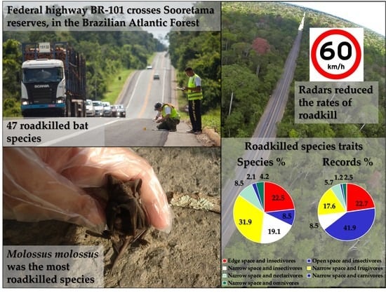
2.1. Study Area

We conducted the study in the protected area complex formed by the SBR, VNR, Mutum Preto Reserve, and Recanto das Antas Reserve located between the coordinates 18°53′40″–19°15′20″ S and 39°44′32″–40°16′51″ W (Figure 1), in the north of Espírito Santo state, southeastern Brazil. This is an area of approximately 53,000 hectares, with 80 years of conservation history, and is herein referred to as Sooretama. Sooretama reserves form one of the largest remnants of the Tabuleiro Forest, an associated type of ecosystem of the Atlantic Forest, that consists of lowland forest (formed on sedimentary plains that originated in the Pliocene) intersected by wide and shallow valleys with tabuleiro forests as the dominant vegetation, with lesser enclaves of mussununga (a vegetation on Tertiary sandy soils of central Atlantic Forest) and native grassland [44]. The altitude varies locally between 28 and 65 m above sea level [45], and the climate is tropical with a dry winter (Aw) according to the Köppen system [46], with approximately 80% of annual rainfall distributed between October and March [47,48].
Since the 1960s, Sooretama has been intersected by a stretch of federal highway BR-101 [40] (Figure 1), which is 15 m wide and approximately 25 km long, and between the years 2011 and 2017, two electronic speed surveillance radar (radars) were installed at each end of the 5.1 km portion of the highway that directly crosses the SBR, limiting the speed to 60 km/h. The radar located at Km 102.8 was installed in January 2011 and began operations in August of the same year, whereas the radar located at Km 107 was established in August 2011 and activated in June 2012.

2.2. Data Collection

Bat data were obtained between August 2010 and December 2015 from the segment of highway BR-101 that crosses Sooretama. Two types of monitoring were used to collect the data: by foot and by car. Monitoring by foot was carried out on the 5.1 km stretch that only crosses the SBR (rote 1) (Figure 1), from August 2010 to December 2015, with a total of 969 days of sampling, and on the 6 km stretch that only crosses the VNR (rote 2) (Figure 1), from July 2014 to September 2015, with a total of 38 days of sampling. Monitoring by car was conducted over the entire 25 km stretch (Figure 1), at a speed between 40 km/h to 50 km/h, from April 2013 to April 2015, with a total of 208 days of sampling. In the months when the two monitoring methods overlapped, they were alternated (in the days which the monitoring occurred by foot, there was no monitoring by car, and vice versa). Monitoring was carried out in the morning, between 07:00 and 12:00, and data from specimens found outside of this period were also collected and considered sporadic.
The roadkill data were recorded on a spreadsheet, including the specimen number, the highway kilometer where the animal was found, and the date and time of the observation. The coordinates of the collection site were determined by GPS (Garmin Etrex 10) and the location was photographed. Photographs, carcasses, and samples for species identification were obtained between 2013 and 2015 (between 2010 and 2012 there was no collection of these data). Carcasses of specimens found in suitable condition were collected for identification using morphological characters. Bat tissue samples were collected and placed in 1.5 mL microtubes with 90–95% alcohol.
The monthly precipitation data were obtained from the weather radar in the city of São Mateus, Espírito Santo, which was the radar closest to the reserves, between the coordinates 18°40′33″ S and 39°51′50″ W [49], approximately 38 km away.

2.3. Species Identification

The collected carcasses were identified at the lowest taxonomic level using the identification keys of Díaz et al. [50] and Gregorin and Taddei [51]. After identification, they were packed in formaldehyde or frozen. The photographs aided in the taxonomic identification, but they were not considered alone as an identification of species. During the period from September 2011 to December 2012, the records were neither photographed nor collected, making the identification impossible. Thirty roadkilled individuals which had tissue samples collected were genetically identified using DNA barcoding. The cytochrome oxidase I (COI) gene was sequenced according to Klippel et al. [42] and the result was compared to reference sequences of the species deposited in the Barcode of Life Data System—BOLD (Centre for Biodiversity Genomics, Guelph, ON, Canada, https://www.boldsystems.org/, accessed on 22 September 2020) [52] and GenBank (National Center for Biotechnology Information NCBI, National Institutes of Health, Bethesda, MD, USA, https://www.ncbi.nlm.nih.gov/genbank/, accessed on 22 September 2020) [53] databases.

2.4. Data Analysis

The abundance of the roadkilled species identified was quantified. The feeding guilds of the species were classified into insectivores, frugivores, carnivores, omnivores, and nectarivores [54]. The flight types of the species were classified by structural habitat type: edge space, narrow space, and open space [55].
The data on the abundance of bat species involved in vehicle accidents at the SBR and VNR were compared to those obtained from the work of Pimenta [56] and Gnocchi et al. [57], respectively, which were carried out in the same regions as our study, using mist nets to collect individuals. The abundance data of roadkilled bat species over the entire 25 km stretch were also compared to data obtained from the work of Pimenta [56] and Gnocchi et al. [57]. The differences in abundances were tested using the Wilcoxon test. The same test was used to compare the abundance of food guilds recorded in the roadkill with those present in the reserves. We also compared the percentages of species and individual bats killed by flight type in each food guild, to assess whether roadkill was related to the type of flight in the guilds. The analyses were performed using the Systat 13 program (Systat Software Inc., San Jose, CA, USA, https://systatsoftware.com/, accessed on 22 September 2020).
Species richness was separately analyzed. Each day of monitoring was considered a sample unit (sample-based), and the species accumulation curve was analyzed using the species richness estimator Chao1. The analysis was also used to compare the monitoring carried out by foot and by car on both the SBR highway section and the 6 km section that crosses the VNR. The analyses were performed using the R program (RStudio Team 2020, Boston, MA, USA, http://www.rstudio.com/, accessed on 22 September 2020).
The roadkill rate (individual/km/day) was calculated for each monitoring method and used for the comparative analyses between the types of monitoring, among the sampled stretches, and between the effect of radars and seasonality. To assess whether there were significant differences between the monitoring by foot and by car, the Mann–Whitney test of comparison of means was applied to the data from the years that the monitoring overlapped in the 5.1 km stretch that crosses the SBR and 6 km that crosses the VNR. ANOVA and the Tukey a posteriori test (Tukey’s honest significance test with unequal sample sizes) were used to assess whether there was a difference in car monitoring in the three sampled stretches (SBR, VNR, and surroundings), and in roadkill rate with monitoring by foot among the years and months on the 5.1 km stretch of highway that crosses the SBR. The analyses were performed using the Systat 13 program.
To compare whether the presence of radars reduced the roadkill rate, we classified the roadkill rates for the portions of highway where the radars were installed (km 101–102 and km 106–107) into four periods: (1) radars not yet present (No radar) (km 101–102, from August 2010 to December 2010; and km 106–107, from August 2010 to July 2011); (2) Installed radar (km 101–102, from January 2011 to July 2011; and km 106–107, from August 2011 to May 2012); (3) Operation radar 1 (km 101–102, from August 2011 to January 2012; km 106–107, from December 2012 to February 2014); and (4) Operation radar 2 (km 101–102, from January 2015 to June 2015; km 106–107, from August 2014 to December 2015). Because the period with the radars in operation was more than twice the number of months as the previous period, we performed a correlation analysis to assess if there was variation in the roadkill rate over those months and found a significant increase from the beginning of the radars’ operation until the end of the period studied (R = 0.63, p < 0.001). Therefore, we performed ANOVA and Tukey a posteriori tests to assess whether there was a difference in roadkill rate between the periods.
To determine if there was a relationship between precipitation and the roadkill rate, we performed a correlation test using the Spearman method. The analysis was performed using the R program.

3. Results

3.1. Bat Diversity

A total of 773 bats were killed by vehicle impact on the 25 km stretch of the BR-101 highway that crosses the Sooretama reserves, of which 432 were identified at some taxonomic level, and 341 were not identified (Table 1). At the species level, 212 individuals were identified, of which 169 were ascertained by morphological specimen identification (79.72%), 30 by DNA barcoding (14.15%), and 13 by photographs (6.13%). Two hundred and twenty records were identified only at non-species taxonomic levels, with 107 families, 31 subfamilies, and 82 genera; of which 202 were determined from photographs (91.82%) and 18 by morphological specimen identification (8.18%).
In total, 47 species were identified, belonging to 33 genera, from five subfamilies, and seven families (Table 1). The species Molossus molossus was the most represented, with 65 records (30.7%) identified from vouchers, followed by Saccopteryx bilineata, with 10 records (4.7%), and Carollia perspicillata, with eight records (3.8%).

3.2. Diversity and Abundance by Method and Monitoring Stretch

In the sampling carried out by foot for route 1, 36 species were recorded; however, the estimated richness was 41 species. Car monitoring on the same stretch returned 10 species, whereas the estimate was 22. For route 2, 11 were recorded by foot monitoring and the estimate was 50 species, and two were recorded by car, where the estimate was three species. In the 13.9 km stretch around the reserves, the sampling performed by car recorded seven species and the estimate was 19 species.
The proportion of individuals recorded in the roadkill by SBR category corresponded only to 10.5% of those captured in the mist nets by Pimenta [56]. The proportions of the abundance of species killed on the highway compared to those caught in the mist nets were significantly different (Z = −3.194, p = 0.0014) (Supplementary Materials Figure S1, Table S1). However, when analyzed only by family, the number of roadkill animals was proportional to those captured in mist nets (Z = −1.572, p = 0.1159) (Supplementary Materials Table S1). The species most found in the mist nets and roadkill were of the family Phyllostomidae (n = 2074 and n = 82, respectively), followed by Molossidae (n = 114 and n = 64, respectively), Vespertilionidae (n = 66 and n = 26, respectively), and Emballonuridae (n = 33 and n = 22, respectively). The families Furipteridae, Thyropteridae, and Natalidae were recorded only in roadkill (n = 3, n = 11 and n = 1, respectively).
The number of individuals recorded in roadkill on the VNR corresponded to 7.3% of those captured in the mist nets by Gnocchi et al. [57]. The proportion of the abundance of species roadkilled compared to those caught in the mist nets differed significantly in the VNR (Z = −4.445, p < 0.0001) (Supplementary Materials Figure S2, Table S1). When analyzed by family only, the number of roadkill animals was proportional to those captured in mist nets (Z = −1.626, p = 0.1041) (Supplementary Materials Table S1). The species most identified in both the mist nets roadkill were those of the family Phyllostomidae (n = 164 and n = 7, respectively), followed by Molossidae (n = 55 and n = 6, respectively), and Vespertilionidae (n = 24 and n= 3, respectively). The other families (Emballonuridae, Furipteridae, and Thyropteridae) were represented either by one individual or none.
The roadkill species abundances in the SBR and VNR together corresponded to 8.8% of those captured with mist nets by Pimenta [56] and Gnocchi et al. [57]. The proportion of the abundances of species in roadkill compared to those caught in the mist nets differed significantly (Z = −2.934, p = 0.0033) (Supplementary Materials Table S1). When analyzing by family only, the number of animals killed by vehicle impact was proportional to the number of animals captured in nets (Z = −1.472, p = 0.1411) (Supplementary Materials Figure S3; Table S1).

3.3. Feeding Guild and Flight Type

From the 401 bat carcasses found on the highway, the type of flight and the food guild were identified. Overall, narrow space-frugivorous species were most recorded (31.9%), followed by edge space-insectivorous with 12 (25.5%), and narrow space-insectivorous (19.1%) (Figure 2). Open space-insectivorous species were the most recorded as roadkill (41.9%), followed by edge space-insectivorous (22.7%) and narrow space-frugivorous (17.6%) (Figure 2; Table 1). The proportion of roadkill bats by type of flight and guild was significantly different (Z = 2.366; p = 0.018), with the most frequent being open space and insectivores (Figure 2).

3.4. Rates and Pattern of Roadkill

For route 1, monitoring by foot produced 592 records over 969 monitoring days, with a roadkill rate of 0.120 individual/km/day. In route 2, by foot monitoring returned 33 animals in 38 days of monitoring, with a roadkill rate of 0.145 individual/km/day. Car monitoring was carried out on 208 days on the route 1 where 35 records were obtained, with a roadkill rate of 0.033 individual/km/day. Through car monitoring of route 2, three records were obtained, presenting a rate of 0.0024 individual/km/day. In the remaining 13.9 km stretch of the BR-101 in Sooretama, 17 individuals were identified by car monitoring as roadkilled, with a rate of 0.0059 individual/km/day. Throughout the entire 25 km stretch that crosses Sooretama, 55 bats were located by car monitoring, with a rate of 0.0106 individual/km/day.
The roadkill rate was higher for monitoring by foot than by car for the stretches in the SBR (W = 91, p = 0.0001) (Figure 3) and VNR (W = 25, p = 0.0001) reserves. There was no significant difference between the roadkill rates by foot monitoring of route 1 and route 2 (W = 84.5, p = 0.80); however, by car monitoring, the SBR stretch had a roadkill rate higher than that of the VNR stretch and the surrounding 13.9 km (F = 31.486, p = 0.0001).
The different periods in relation to the radars showed a significant difference in the roadkill rate (F = 6.392, p = 0.0006). When compared to the period without radars, the period in which the radars were installed and the beginning of the operating period showed low roadkill rates (p = 0.017 and p = 0.001, respectively) (Supplementary Materials Table S2, Figure 4). However, that there was an increase in the roadkill rate in the second period of the radars in operation compared to the beginning of the operation period (p = 0.027) (Supplementary Materials Table S2, Figure 4). The roadkill rate of the second period of radars in operation did not differ from the period without radars (p = 0.661) (Supplementary Materials Table S2, Figure 4).
For SBR, there was no difference in the roadkill rates along the months (F = 2.065, p = 0.41), although there was a difference among the five years and five months of monitoring by foot (F = 3.512, p = 0.008). Subsequently, using Tukey’s test it was shown that the only significant increase occurred in the roadkill rate in 2015 when compared to previous years (Figure 5). There was a negative relation between the roadkill rate and precipitation, indicating that there was an increase in mortality in the drier periods (R = −0.3, p = 0.016) (Figure 6).

4. Discussion

4.1. Roadkilled Bat Diversity

The number of bat species that died by vehicle impact in the present study exceeds the numbers found in other studies conducted globally (Supplementary Materials Table S3). A review by Ramalho and Aguiar [8] found 76 roadkilled bat species in studies conducted in Europe and in North and South America [10,11,12,13,14,15,16,17,18,19,20,21,22,23,24,25,27,28], with 45 species in Brazil. Other studies conducted in Brazil recorded five species not reported by Ramalho and Aguiar [8]: one by Grillo et al. [26], three by Novaes et al. [27], and one by Ramalho et al. [29]. The present study added 19 species to the 81 species of bats known to be roadkilled globally, and to the 50 in Brazil, increasing the number globally to 100 and in Brazil to 69 (Supplementary Materials Table S4). From all roadkilled species identified globally and in Brazil, 47% and 68.1%, respectively, were found in Sooretama. Sooretama is one of the locations with the greatest known diversity of bats in the Atlantic Forest, with 71 species currently recorded [56,57,58,59,60] (Supplementary Materials Table S5), which is 61.5% of the known bat diversity in this biome. In total, 66.2% of the species present in Sooretama and 40.2% of those in the Atlantic Forest were recorded in roadkill on a stretch of just 25 km of highway in the region.
Of the 24 species that occur in Sooretama and were not observed as roadkill, seven (Glyphonycteris daviesi, G. silvestres, Vampiressa thyone, Diaemus youngi, Thyroptera tricolor, Histiotus velatus, and Myotis levis) were not found on the east side of the BR-101 highway at SBR by Pimenta [56] (Pimenta, pers. comm.), whereas three (Carollia breicauda, Anoura caudiffer, and Lonchophylla mordax) were found only on the east side of the highway in VNR by Peracchi et al. [58]. This suggests that bat communities in forests on opposite sides of the highway may have different compositions. Although this apparent difference may be an effect of different sampling methods, it may also be an effect of the highway itself; this hypothesis was not the subject of the present study but deserves to be investigated. However, Lonchorhina aurita, an insectivorous and carnivorous species [61], was recorded by Pimenta [56] only in culverts under the highway in the SBR, where two individuals were captured using mist nets (Pimenta, per. comm.), but curiously it was not recorded in the extensive effort of sampling the roadkill that we investigated here. It was also not observed as roadkill in other studies. This demonstrates that the highway and its structure can have positive effects for some species of bats. Bridges and culverts can be used as shelters for some species of bats and offer adequate microclimate conditions and protection against predators [62,63,64].
Macrophyllum macrophyllum was only recorded in Sooretama in the present study, with one record. The family Natalidae was only presented in this study through a roadkilled specimen that was photographed, but it was not possible to identify the species. The species Thyroptera wynneae was registered in the region for the first time from a record of a roadkill specimen in 2010 at SBR [59]. This fact illustrates that the highway is a threat and demonstrates its impact on rare bats, as T. wynneae is difficult to collect in mist nets but has been recorded several times as roadkill, although this species has been registered using mist nets in the VNR by Gnocchi et al. [57].
Furipterus horrens, a threatened species considered vulnerable in the Brazilian List of Endangered Species [65], was recorded five times as roadkill; therefore, roads must be considered a threat to the conservation of this species in Brazil.
Only one record was made of Rhinophylla pumilio killed on the highway, and it could only be confirmed with DNA barcoding, since we were unable to identify the pulverized remains of this animal by morphology observation. Molecular analyses are effective in studies of road ecology for the identification of individuals that are difficult to diagnose from the morphology or carcasses severely damaged by vehicle impacts [42]. This importance was also demonstrated by Russell et al. [18], who identified a species of bat threatened with extinction from molecular analysis of roadkill samples on a highway in the USA.
The high number of unidentified records (n = 341) in the present study relates to two factors. First, in the period from September 2011 to December 2012 the records (n = 116) were neither photographed nor collected, making the identification impossible. Second, the high degree of destruction of some carcasses that were consequently not collected (n = 225) made it difficult to identify these records only by photographs.
Despite the high species richness and abundance of roadkilled bats, these results may be underestimated, because of the rapid action of scavengers in removing individuals killed during the night, or devouring significant amounts of the animal, making it impossible to identify, or other causes [66,67,68]. Thus, the real impact of roadkill in Sooretama may be much higher than reported.

4.2. Feeding Guild and Type of Flight of Roadkilled Bats

The insectivore guild was the most affected by roadkill, constituting 25 species and 74% of the records identified. However, the diversity and abundance of roadkilled insectivorous bats in Sooretama could be explained by their own richness and composition in the region. It is more likely to find an insectivorous bat that is roadkilled than collected in a mist net. In a study conducted at SBR using mist nets, Pimenta [56] found greater species diversity and abundance in fruit and insectivorous bats (31.5% and 70.9%, respectively), which differs from that of the present study (Supplementary Materials Figures S1 and S2). In VNR, Gnocchi et al. [57], also using mist nets, found a greater diversity of insectivorous bats (44%) and frugivores (36%), and a greater abundance of insectivorous individuals (~38%) and frugivores (~32%). The diversity and abundance of insectivorous species found in that report were lower than those found in roadkill assessed in the present study (Supplementary Materials Figures S4 and S5, respectively). However, mist netting is not effective in sampling aerial insectivores because some bats fly above the nets and insectivores can detect the mist nets [55]. Thus, the abundance of insectivorous bats tends to be underestimated in studies with mist nets, and the roadkill records made may provide a closer reflection of the real abundance of aerial insectivores and the extent to which highways impact them.
The diversity and abundance of insectivorous bats in roadkill may relate to insects being attracted by the artificial lights of passing vehicles on the highway, or the clearing of the open road into forests. The increase in the activity of insectivorous bats near artificial lighting sources has been observed previously with an abundance of insects attracted by this lighting [69,70], although Ramalho et al. [29] found no relationship between the roadkill of bats on highways in the Neotropical savanna and artificial lighting. The second factor is the biology of species killed by vehicle impact. In Australia, it was observed through bioacoustics that insectivorous bats that use open areas are more likely to be road-killed [71], because they have high speeds and little maneuverability. Our data corroborate this finding because, considering only aerial insectivores, the number of roadkill records with open space flight was twice that of edge space flyers (Figure 2).
Bat species can avoid habitats adjacent to highways [72,73], due to road effect zones, such as the lack of canopy coverage [74], and road and traffic disturbances, such as light and noise [75,76,77]. Bhardwaj et al. [78] investigated insectivorous bats in highly deforested agricultural landscapes in Australia and found that their activities decreased significantly with the proximity of the highway. However, in environments where canopy coverage is dense on the side of the highway, this effect may be reduced and species may persist, although some deterrents may still exist. The high diversity and abundance of roadkill insectivorous bats in Sooretama suggests that the area of highway zone effects may not be as extensive, or it is positive in their activity. However, the BR-101 highway zone effect on bats deserves to be investigated in Sooretama.
Bats play an important ecological role, providing ecosystem services such as pollination, seed dispersal, and insect control [79]. Our study changes the understanding of the bat feeding guild that is most affected by roadkill, which the other studies in the Neotropical region reported as frugivores [25,27]. The most roadkilled bat species in Brazil (53.6%) and the world (68%) are insectivores, followed by frugivores, with 27.5% and 19%, respectively (Supplementary Materials Table S3). The high mortality of insectivorous bats is concerning, because these animals are important predators and controllers of agricultural pest populations [80,81]. The surroundings of Sooretama, for example, are formed by a farm matrix composed of cocoa, coffee, papaya, passion fruit, pepper, eucalyptus, and other crops [44]. Ecosystem services provided by bats in the region may be affected due to the high roadkill rates observed. In agricultural areas in the USA, for example, such services provided from bat predation of pests can reach an approximate value of USD 23 billion annually [81]. In the Neotropical region the contribution of bat ecosystem services has not been estimated, but much of this service is being lost due to unnatural bat demise.

4.3. Roadkill Rates and Pattern

This study was the longest monitoring of roadkilled bats and showed the highest roadkill rates of bats reported globally (Supplementary Materials Table S3). The higher roadkill rates obtained from monitoring by foot clearly demonstrate that the method is much more efficient for detecting bat carcasses than monitoring by car. This fact is explained by the greater ease in detecting carcasses with slower movement through the area at the time of monitoring. Teixeira et al. [82], for example, evaluated the detection rate between the two types of monitoring for small vertebrates, and observed that the detection of carcasses by car is far less compared to that of monitoring by foot. The type of monitoring can even be associated with the type of species detected; for example, in other studies carried out with roadkill bats in Brazil frugivores were the most recorded [25,27], which are generally larger species compared to insectivores, which were most recorded in this study.
Monitoring by car showed that the SBR stretch obtained a bat roadkill rate higher than the VNR stretch and the 13.9 km from the surroundings, but this result differs from expectations. In SBR the highway crosses a dense forest and in the VNR and surroundings there are different land uses around the highway, most of which is open area. Open areas are used by bats that fly at a higher speed and have little maneuverability and are more susceptible to vehicle impacts [71]. Secco et al. [25] observed that bats were more liable to become impacted by vehicles in places with open areas in a region of the Atlantic Forest. However, it is noteworthy that when monitoring by foot in Sooretama, we found no difference between the roadkill bat rates obtained on the SBR and on the VNR stretches.
The evident increase in roadkill rates at the end of our study period may be related to the severe drought that the region experienced in 2015 (see Branco et al. [83]), since because roadkill rates were higher in the drier months (Figure 6). Modeling the effects of climate change on bats leads to the prediction that populations of different species tend to move to other regions because of changing environmental conditions [84]. This raises the hypothesis that in periods of prolonged droughts, there is an increase in the displacement of bats in search of resources. Thus, climate change can increase the effect of roadkill on bat communities, at least in the Neotropical forest. In contrast, Ramalho et al. [29] found that the number of bats roadkilled was higher in the rainiest period in the Neotropical savannah.
The fact that there is no significant difference among the months in the roadkill rates indicates that seasonality has no effect on them, and they were constant throughout the year where the present study was carried out. Secco et al. [25] also reported that the number of roadkilled bats was similar throughout the year in an area in the southeast region of the Atlantic Forest. This differs from what occurs in the temperate region, where roadkill rates are higher in the reproductive period [15,17]. Generally, bats have up to two pregnancies per year and one offspring per pregnancy [85]. In the present study, we identified 102 females and 64 males, and 156 adults and 10 juveniles of different bat species (Table S6). At least four pregnant females (two M. molossus, one Eptesicus furinales, and one Platyrrhinus incarum) were confirmed as roadkill, which indicates that there can be a direct effect on the recruitment of bat populations in the study area, considering that roadkill occurs both inside and outside the reproductive period, and involves numerous females and juveniles.
In the late 1960s, highway BR-101 was built across Sooretama despite the main Brazilian environmental law of the time, the Forest Code of 1965, which did not allow such construction inside protected forest areas [40], and the problems caused from this construction have not yet been adequately mitigated. The two radars of 60 km/h that were installed in 2011 promoted a significant reduction in roadkill of bats in the two years following their installation/operation (Figure 4). These rates have not only been reduced locally in the stretch where the radars were installed, but along the entire length, because roadkill rates in the section that crosses the SBR in the years before the installation of the radars, 2010 and 2011, were higher than those of 2012, 2013, and 2014. The speed of traffic on the road is a factor that directly influences roadkill [86,87]. However, there was a significant increase in the last year of sampling (2015) in roadkill rates (Figure 5). In 2017, the radars were removed from the highway, and in 2021, the radars were reinstalled, but the speed limit was raised to 80 km/h. We have made sporadic visits to the stretch in recent years and found that roadkill in the reserves remains chronic, and the section of the BR-101 that crosses the reserves is planned to be duplicated, which can further aggravate the roadkill rates.
Mitigation measures to avoid wildlife death should be established in highway developments in regions of high bat diversity in the Neotropical forest. However, measures to reduce roadkill are often not considered in road planning, particularly in relation to bats. Although there are many potential strategies to mitigate the effects of road construction on bats, the effectiveness of these measures needs to be tested in various regions to ensure bat preservation [8]. In the present study, we showed that a speed limit of 60 km/h with electronic surveillance can be effective in reducing roadkill of bats along a stretch of highway. The installation of “overpasses” that direct the flight of bats above the highway also can be effective in reducing the mortality of bats [88]. An alternative to preserve these bats in Sooretama reserves is closing the BR-101 highway or reducing the traffic of vehicles at night when bats are active, which would also preserve other nocturnal species that are also roadkill.

5. Conclusions

The diversity of roadkill bat species in the Sooretama reserves is among the highest in the world, and the abundance is also high, especially for open space-aerial insectivorous bats. Considering the roadkill rates found in the present study, tens of thousands of bats have been roadkilled along the 25 km that crosses the Sooretama reserves since the BR-101 highway was opened, which may have reduced species populations. Further research is needed on bat species abundances to estimate the extent to which roadkill affects the viability of populations over the long term. Furthermore, there is a need to investigate the effect of the highway zone on bats’ activity. The high roadkill rates did not present a seasonal pattern, and roadkill affected bat populations in the Atlantic Forest, both inside and outside of the reproductive period. However, roadkill rates were higher in the driest year of the forest, likely in relation to the need for greater movement of bats in search of resources. Radars with a speed limit below 60 km/h were shown to reduce roadkill rates and must be considered in a mitigation plan. We recommend testing the effectiveness of reducing roadkill rates by implementing bumps to reduce vehicles speed. However, closing the BR-101 highway or reducing the traffic of vehicles in Sooretama reserves at night are measures that can be used to avoid the vehicular death of these animals. The success in diagnosing the diversity of bats roadkilled in the present study is credited to the methods used. Thus, we suggest that studies monitoring roadkill fauna on highways must be conducted by foot, with the collection of vouchers of the carcasses themselves or/and tissue, complemented with efficient species identification tools where possible, such as the application of DNA barcoding. Roadkill is an unseen and silent threat to the diversity of bats in the Neotropical forest.

Supplementary Materials

The following are available online at https://www.mdpi.com/article/10.3390/d13070335/s1, Figure S1: Proportion of bat species recorded in roadkill (gray) and the proportion of species recorded in mist nets (black) from the study of Pimenta (2013) in the SBR, Figure S2: Proportion of bat species recorded in roadkill (gray) and the proportion of species recorded in mist nets (black) from the study of Gnocchi (2019) in the VNR, Figure S3: Proportion of bat families recorded in roadkill (gray) and the proportion of species recorded using mist nets (black) in the studies of Pimenta (2013) and Gnocchi (2019) in the SBR and VNR, Figure S4: Percentage of species recorded by type of flight in each trophic guild in roadkill (black) and reported by Pimenta (2013) (dark gray) and by Gnocchi et al. (2019) (light gray) using mist nets. ES = edge space; OS = open space; NS = narrow space; I = insectivores; F = frugivores; C = carnivores; O = omnivores; N = nectarivores. The black bars represent the species, and the dark gray bars represent the records of roadkill by guild, Figure S5: Percentage of individual records by type of flight in each trophic guild found in roadkill (black), and reported by Pimenta (2013) (dark gray) and by Gnocchi et al. (2019) (light gray) using mist nets. ES = edge space; OS = open space; NS = narrow space; I = insectivores; F = frugivores; C = carnivores; O = omnivores; N = nectarivores, Table S1: Values of the Wilcoxon non-parametric test (Z) and level of significance (p) when comparing the roadkill data with the captured specimen list with mist nets (Pimenta, 2013 and Gnocchi et al., 2019). In the last comparison, we removed the records of the Phyllostomidae family. The value in parentheses corresponds to the sample size, Table S2: Results of the Tukey test with comparisons between periods: No Radar, Installed Radar, Operation Radar1, and Operation Radar2, Table S3: Studies of roadkilled bats worldwide. Shows the country, road extension, monitoring type, and roadkill rate (individual/km/day) from each study when informed. No information is represented by ni, Table S4: Bat species and feeding guilds identified in studies of roadkilled bats in different countries by Ramalho and Aguiar (2020) updated by Damásio et al. (this study). Data presents 24 new roadkilled species in Brazil added to 76 species globally by Ramalho and Aguiar (2020): 19 by Damásio (this study), one by Ramalho et al. (2021), one by Grillo et al. (2018), and three by Novaes et al. (2018), which were omitted from the Ramalho and Aguiar (2020) list. I = insectivorous, p = piscivorous, N = nectarivorous, F = frugivorous, C = carnivorous, H = hematophagous, O = omnivorous, AUS = Australia, BRA = Brazil, BUL = Bulgaria, CZE = Czech Republic, FRA = France, GER = Germany, MON = Montenegro, SPA = Spain, USA = United States of America, Table S5: Bat species from the Sooretama reserves. Reference: [01] Damasio et al. (this study); [02] Pimenta (2013); [03] Vela-Ulian et al. (2021); [04] Peracchi et al. (2011); [05] Gnocchi et al. (2019); [06] Hoppe et al. (2013), Table S6. Sex and age of the roadkilled bat species in the 25 km of highway BR-101 that crosses the Sooretama reserves. Shows only the number of individuals that it was possible to identify the age and sex.

Author Contributions

Conceptualization, L.D. and A.B.; methodology, L.D., L.A.F., V.T.P., G.G.P. and A.B.; formal analysis, L.D., L.A.F., G.G.P., H.G.B. and A.B.; investigation, L.D. and A.B.; resources, L.D., L.A.F., V.T.P., G.G.P., A.R.d.S., A.D.D., H.G.B. and A.B.; data curation, L.D. and A.B.; writing—original draft preparation, L.D., H.G.B. and A.B.; writing—review and editing, L.D., G.G.P., A.D.D., H.G.B. and A.B.; visualization, L.D., L.A.F., V.T.P., G.G.P., A.R.d.S., A.D.D., H.G.B. and A.B.; supervision, A.B.; funding acquisition, A.B., A.R.d.S., G.G.P. and H.G.B. All authors have read and agreed to the published version of the manuscript.

Funding

This study was supported by the Universidade Federal do Espírito Santo, by the Fundação de Amparo à Pesquisa e Inovação do Espírito Santo [grant number FAPES 0876/2012, FAPES 61901857/2013 and FAPES 0876/2015], National Council of Technological and Scientific Development [grant numbers 475862/2012-0 and 457458/2012-7-PPBio Rede Mata Atlântica].

Institutional Review Board Statement

Ethical review and approval were waived for this study, due to: in Brazil, in view of Article 5, items I and IV, of Law No. 11.794, of 8 October 2008, and the provisions of items I and IV of Article 4 of Decree No. 6.899, of 15 July 2009, the Ministry of Science, Technology, Innovations and Communications published Normative Resolution No. 30, of 2 February 2016, which establishes the Brazilian Guideline for the Care and Use of Animals in Teaching or Scientific Research Activities (Diretriz Brasileira para o Cuidado e a Utilização de Animais em Atividades de Ensino ou de Pesquisa Científica-DBCA). The DBCA in item 6.1.10b provides that when cadavers, parts of them or biological samples from animals roadkilled on highways are used in teaching or scientific research activities, those responsible for the activity must maintain documentation that unequivocally evidences the origin of the material, no need to register the research with the Ethics Committee. In this study, the SISBIO 31762 license issued by the Chico Mendes Institute for Biodiversity Conservation is the official document that proves the origin of the material.

Informed Consent Statement

Not applicable.

Data Availability Statement

The data can be found in Supplementary Materials.

Acknowledgments

We would like to thank Instituto Chico Mendes de Conservação da Biodiversidade for its permission to sample the roadkilled biological communities in the Sooretama reserves [SISBIO 31762]; Natural Vale Reserve for allowing to use its accommodation and field laboratory; and the Chief of SBR Eliton Lima and the Environmental Analyst Valdir Martins Santos for support during field work. We are especially grateful to Environmental Analysts Marcel Redling Moreno, who coordinated the collection of data by car and on foot; Ruan Preato Deolindo, Alexsander Leandro da Silva, Maria Alice Moreira Machado, Lucas Mendes Barreto, Genilson T. Silva Junior, Luis Francisco O. P. Gonzaga, Savio Augusto Machado, Juliana Kruger, and Marcos Vinícius F. Silva for collecting samples on highway; Leonardo Merçon for the aerial photos of the BR-101 highway in the SBR used in the graphic abstract and Figure 1; João Marcos Rosa for the photo of the team working used in the graphic abstract; Ana Carolina Srbek de Araújo, Charles Gladstone Duca, and Elvis Ricardo Figueira Branco for sharing technical information to carry out this work; Vitor Roberto Schettino for making the map figure; Natália C. Ardente for preliminary review of this paper.

Conflicts of Interest

The authors declare no conflict of interest.

References

  1. Forman, R.T.T.; Alexander, L.E. Roads and Their Major Ecological Effects. Annu. Rev. Ecol. Syst. 1998, 29, 207–231. [Google Scholar] [CrossRef] [Green Version]
  2. Trombulak, C.S.; Frissel, A.C. Review of Ecological Effects of Roads on Terrestrial and Aquatic Communities. Conserv. Biol. 2000, 14, 18–30. [Google Scholar] [CrossRef]
  3. Coffin, A.W. From roadkill to road ecology: A review of the ecological effects of roads. J. Transp. Geogr. 2007, 15, 396–406. [Google Scholar] [CrossRef]
  4. Laurance, W.F.; Goosem, M.; Laurance, S.G.W. Impacts of roads and linear clearings on tropical forests. Trends Ecol. Evol. 2009, 24, 659–669. [Google Scholar] [CrossRef]
  5. Balkenhol, N.; Waits, L.P. Molecular road ecology: Exploring the potential of genetics for investigating transportation impacts on wildlife. Mol. Ecol. 2009, 18, 4151–4164. [Google Scholar] [CrossRef]
  6. Holderegger, R.; Di Giulio, M. The genetic effects of roads: A review of empirical evidence. Basic Appl. Ecol. 2010, 11, 522–531. [Google Scholar] [CrossRef]
  7. Altringham, J.; Kerth, G. Bats and Roads. In Bats in the Anthropocene: Conservation of Bats in a Changing World; Voigt, C.C., Tigga, K., Eds.; Springer Nature: Cham, Switzerland, 2016. [Google Scholar] [CrossRef]
  8. Ramalho, D.F.; Aguiar, L.M.S. Bats on the Road—A Review of the Impacts of Roads and Highways on Bats. Acta Chiropterol. 2020, 22, 417–433. [Google Scholar] [CrossRef]
  9. Burgin, C.J.; Colella, J.P.; Kahn, P.L.; Upham, N.S. How many species of mammals are there? J. Mammal. 2018, 99, 1–14. [Google Scholar] [CrossRef] [Green Version]
  10. Rackow, W.; Harz, O.; Schlegel, D. Fledermäuse (Chiroptera) als Verkehrsopfer in Niedersachsen. Nyctalus 1994, 5, 11–18. [Google Scholar]
  11. Kiefer, A.; Merz, H.; Rackow, W.; Roer, H.; Schlegel, D. Bats as traffic casualties in Germany. Myotis 1995, 32–33, 215–220. [Google Scholar]
  12. Haensel, J.; Rackow, W. Fledermause als Verkehrsopferein neuer report. Nyctalus 1996, 6, 29–47. [Google Scholar]
  13. Bafaluy, J.J. Mortandad De Murciélagos Por Atropello En Carreteras Del Sur De La Provincia De Huesca. Galemys 2000, 12, 15–23. [Google Scholar]
  14. Capo, G.; Chaut, J.J.; Arthur, L. Quatre ans d’étude de mortalité des Chiroptères sur deux kilomèters routiers proches d’un site d’hibernation. Symbioses 2006, 15, 45–46. [Google Scholar]
  15. Lesiński, G. Bat road casualties and factors determining their number. Mammalia 2007, 71, 138–142. [Google Scholar] [CrossRef]
  16. Lesiński, G. Linear landscape elements and bat casualties on roads—An example. Ann. Zool. Fenn. 2008, 45, 277–280. [Google Scholar] [CrossRef]
  17. Gaisler, J.; Řehák, Z.; Bartonička, T. Bat casualties by road traffic (Brno-Vienna). Acta Theriol. 2009, 54, 147–155. [Google Scholar] [CrossRef]
  18. Russell, A.; Butchkoski, C.; Saidak, L.; McCracken, G. Road-killed bats, highway design, and the commuting ecology of bats. Endanger. Species Res. 2009, 8, 49–60. [Google Scholar] [CrossRef]
  19. Lesiński, G.; Sikora, A.; Olszewski, A. Bat casualties on a road crossing a mosaic landscape. Eur. J. Wildl. Res. 2011, 57, 217–223. [Google Scholar] [CrossRef] [Green Version]
  20. Medinas, D.; Marques, J.T.; Mira, A. Assessing road effects on bats: The role of landscape, road features, and bat activity on road-kills. Ecol. Res. 2013, 28, 227–237. [Google Scholar] [CrossRef] [Green Version]
  21. Iković, V.; Đurović, M.; Prestenik, P. First data on bat traffic casualties in Montenegro. Vespertilio 2014, 17, 89–94. [Google Scholar]
  22. Parise, C. Etude de la mortalité des chauves-souris (etautres animaux sauvages) par collision routière das deus secteurs de Champagne-Ardenne. Naturale 2014, 5, 58–64. [Google Scholar]
  23. Alves, D.M.D.; Barros, R.F.; Nepomuceno, C. Levantamento de vertebrados silvestres atropelados com enfoque em indivíduos da ordem Chiroptera: Estudo de caso da rodovia MGC-354, Minas Gerais, Brasil. Perquirere 2015, 12, 176–193. [Google Scholar]
  24. Ceron, K.; Bôlla, D.A.S.; Mattia, D.L.; de Carvalho, F.; Zocche, J.J. Roadkilled bats (Mammalia: Chiroptera) in two highways of Santa Catarina state, Southern Brazil. Oecol. Aust. 2017, 21, 207–212. [Google Scholar] [CrossRef]
  25. Secco, H.; Gomes, L.A.; Lemos, H.; Mayer, F.; Machado, T.; Guerreiro, M.; Gregorin, R. Road and landscape features that affect bat roadkills in Southeastern Brazil. Oecol. Aust. 2017, 21, 323–336. [Google Scholar] [CrossRef]
  26. Grilo, C.; Coimbra, M.R.; Cerqueira, R.C.; Barbosa, P.; Dornas, R.A.P.; Gonçalves, L.O.; Teixeira, F.Z.; Coelho, I.P.; Schmidt, B.R.; Pacheco, D.L.K.; et al. Brazil road-kill: A data set of wildlife terrestrial vertebrate road-kills. Ecology 2018, 99, 2625. [Google Scholar] [CrossRef]
  27. Novaes, R.L.M.; Laurindo, R.S.; Dornas, R.A.P.; Esbérard, C.E.L.; Bueno, C. On a collision course: The vulnerability of bats to roadkills in Brazil. Mastozool. Neotrop. 2018, 25, 115–128. [Google Scholar] [CrossRef]
  28. Stoianova, D.; Karaivanov, N.; Simov, N. Bat (Mammalia: Chiroptera) road casualties in the Kresna Gorge, Bulgaria. In ARPHA Conference Abstracts; Pensoft Publishers: Sofia, Bulgaria, 2019; Volume 2, p. e46469. [Google Scholar] [CrossRef]
  29. Ramalho, D.F.; Resende, D.; de Oliveira, T.F.; Santos, R.A.L.; Aguiar, L.M.S. Factors influencing bat road casualties in a Neotropical savanna. Perspect. Ecol. Conserv. 2021, 19, 189–194. [Google Scholar] [CrossRef]
  30. Clare, E.L.; Lim, B.K.; Fenton, M.B.; Hebert, P.D.N. Neotropical Bats: Estimating Species Diversity with DNA Barcodes. PLoS ONE 2011, 6, e22648. [Google Scholar] [CrossRef]
  31. Nogueira, M.R.; de Lima, I.P.; Moratelli, R.; Tavares, V.D.C.; Gregorin, R.; Peracchi, A.L. Checklist of Brazilian bats, with comments on original records. Check List 2014, 10, 808–821. [Google Scholar] [CrossRef] [Green Version]
  32. Varzinczak, L.H.; Bernardi, I.P.; Passos, F.C. Is the knowledge of bat distribution in the Atlantic Rainforest sufficient? Comments about new findings and a case study in the Paraná State coastal area, Brazil. Mammalia 2015, 80, 263–269. [Google Scholar] [CrossRef]
  33. Graipel, M.E.; Cherem, J.J.; Monteiro-Filho, E.L.A.; Carmignotto, A.P. Mamíferos da Mata Atlântica. In Revisões Em Zoologia: Mata Atlântica; Monteiro-Filho, E., Conte, C., Eds.; Universidade Federal do Paraná: Curitiba, Brazil, 2017; pp. 391–482. [Google Scholar]
  34. Mittermeier, R.A.; Giland, P.R.; Mittermeier, G.G. Megadiversity—Earth’s Biologically Wealthiest Nations; CEMEX and Agrupacion Sierra Madre: Monterrey, Mexico, 1997. [Google Scholar]
  35. Garbino, G.S.T.; Gregorin, R.; Lima, I.P.; Loureiro, L.; Moras, L.M.; Moratelli, R.; Nogueira, M.R.; Pavan, A.C.; Tavares, V.C.; Nascimento, M.C.; et al. Updated Checklist of Brazilian Bats: Versão 2020. Comitê da Lista de Morcegos do Brasil—CLMB. Sociedade Brasileira Para o Estudo de Quirópteros (Sbeq). Available online: https://www.sbeq.net/lista-de-especies (accessed on 22 September 2020).
  36. Myers, N.; Mittermeier, R.A.; Mittermeier, C.G.; da Fonseca, G.A.B.; Kent, J. Biodiversity hotspots for conservation priorities. Nature 2000, 403, 853–858. [Google Scholar] [CrossRef] [PubMed]
  37. Fernandes, G.W.; Banhos, A.; Barbosa, N.P.U.; Barbosa, M.; Bergallo, H.G.; Loureiro, C.G.; Overbeck, G.E.; Solar, R.; Strassburg, B.B.N.; Vale, M.M. Restoring Brazil’s road margins could help the country offset its CO2 emissions and comply with the Bonn and Paris Agreements. Perspect. Ecol. Conserv. 2018, 16, 105–112. [Google Scholar] [CrossRef]
  38. Dean, W. A Ferro e Fogo: A História e a Devastação da Floresta Atlântica Brasileira; Companhia das Letras: São Paulo, Brazil, 2004. [Google Scholar]
  39. Ribeiro, M.C.; Metzger, J.P.; Martensen, A.C.; Ponzoni, F.J.; Hirota, M.M. The Brazilian Atlantic Forest: How much is left, and how is the remaining forest distributed? Implications for conservation. Biol. Conserv. 2009, 142, 1141–1153. [Google Scholar] [CrossRef]
  40. Instituto Brasileiro de Desenvolvimento Florestal. Plano de Manejo Reserva Biológica de Sooretama; Instituto Brasileiro de Desenvolvimento Florestal: Brasília, Brazil, 1981. [Google Scholar]
  41. United Nations Educational, Scientific and Cultural Organization. Twenty-Third Session of the World Heritage Committee—Marrakesh, Morocco. 1999. Available online: http://whc.unesco.org/archive/1999/whc-99-conf209-22e.pdf (accessed on 22 September 2020).
  42. Klippel, A.H.; Oliveira, P.V.; Britto, K.B.; Freire, B.F.; Moreno, M.R.; dos Santos, A.R.; Banhos, A.; Paneto, G.G. Using DNA Barcodes to Identify Road-Killed Animals in Two Atlantic Forest Nature Reserves, Brazil. PLoS ONE 2015, 10, e0134877. [Google Scholar] [CrossRef] [PubMed]
  43. Srbek-Araujo, A.; Mendes, S.; Chiarello, A. Jaguar (Panthera onca Linnaeus, 1758) roadkill in Brazilian Atlantic Forest and implications for species conservation. Braz. J. Biol. 2015, 75, 581–586. [Google Scholar] [CrossRef] [PubMed]
  44. Rolim, S.G.; Menezes, L.F.T.; Srbek-Araujo, A.C. Floresta Atlântica de Tabuleiro: Diversidade e Endemismo na Reserva Natural Vale; Editora Rona: Belo Horizonte, Brazil, 2016. [Google Scholar]
  45. Jesus, R.M.; Souza, A.L.; Garcia, A. Produção Sustentável de Floresta Atlântica, Documento Sociedade de Investigações Florestais; Sociedade de Investigações Florestais: Viçosa, Brazil, 1992. [Google Scholar]
  46. Alvares, C.A.; Stape, J.L.; Sentelhas, P.C.; Gonçalves, J.D.M.; Sparovek, G. Köppen’s climate classification map for Brazil. Meteorol. Z. 2013, 22, 711–728. [Google Scholar] [CrossRef]
  47. Engel, V.L.; Martins, F.R. Reproductive phenology of Atlantic forest tree species in Brazil: An eleven year study. Trop. Ecol. 2005, 46, 1–16. [Google Scholar]
  48. Jesus, R.M.; Rolim, S.G. Fitossociologia da Mata Atlântica de Tabuleiro; Boletim Técnico da Sociedade de Investigações Florestais: Viçosa, Brazil, 2005. [Google Scholar]
  49. Instituto Nacional de Meteorologia. Dados Meteorológicos. Available online: https://tempo.inmet.gov.br/ (accessed on 22 September 2020).
  50. Díaz, M.M.; Solari, S.; Aguirre, L.F.; Aguiar, L.M.S.; Barquez, R.M. Clave de Identificación de los Murciélagos de Sudamérica/Chave de Identificação dos Morcegos da América Do Sul, 2nd ed.; Programa de Conservación de los Murciélagos de Argentina: Tucumán, Argentina, 2016. [Google Scholar]
  51. Gregorin, R.; Taddei, V. Chave artificial para a identificação de molossídeos brasileiros (Mammalia, Chiroptera). Mastozool. Neotrop. 2002, 9, 13–32. [Google Scholar]
  52. Ratnasingham, S.; Hebert, P.D. BOLD: The Barcode of Life Data System (http://www.barcodinglife.org). Mol. Ecol. Notes 2007, 7, 355–364. [Google Scholar] [CrossRef] [Green Version]
  53. Benson, D.A.; Cavanaugh, M.; Clark, K.; Karsch-Mizrachi, I.; Lipman, D.J.; Ostell, J.; Sayers, E.W. GenBank. Nucleic Acids Res. 2012, 41, 36–42. [Google Scholar] [CrossRef] [Green Version]
  54. Reis, N.R.; Fregonezi, M.N.; Peracchi, A.L.; Shibatta, O.A. Morcegos do Brasil: Guia de Campo; Technical Books Editora: Rio de Janeiro, Brazil, 2013. [Google Scholar]
  55. Kalko, E.K.V.; Villegas, S.E.; Schmidt, M.; Wegmann, M.; Meyer, C.F.J. Flying high—Assessing the use of the aerosphere by bats. Integr. Comp. Biol. 2008, 48, 60–73. [Google Scholar] [CrossRef] [Green Version]
  56. Pimenta, V.T. Segregação de Recursos por Diferentes Espécies de Morcegos (Mammalia: Chiroptera) na Reserva Biológica de Sooretama. Master’s Thesis, Universidade Federal do Espírito Santo, Vitória, Brazil, 2013. [Google Scholar]
  57. Gnocchi, A.P.; Huber, S.; Srbek-Araujo, A.C. Diet in a bat assemblage in Atlantic Forest in southeastern Brazil. Trop. Ecol. 2019, 60, 389–404. [Google Scholar] [CrossRef]
  58. Peracchi, A.L.; Nogueira, M.R.; de Lima, I.P. Novos achegos à lista dos quirópteros do município de Linhares, estado do Espírito Santo, sudeste do Brasil (Mammalia, Chiroptera). Chiropt. Neotrop. 2011, 17, 842–852. [Google Scholar]
  59. Hoppe, J.P.M.; Pimenta, V.T.; Ditchfield, A.D. First occurrence of the recently described Patricia’s Disk-winged bat Thyroptera wynneae (Chiroptera: Thyropteridae) in Espírito Santo, southeastern Brazil. Check List 2014, 10, 645–647. [Google Scholar] [CrossRef]
  60. Vela-Ulian, C.M.; Hoppe, M.J.P.; Ditchfield, A.D. New records of bats (Chiroptera) in the Atlantic Forest of Espírito Santo, southeastern Brazil. Mammalia 2021, 85, 52–63. [Google Scholar] [CrossRef]
  61. Emmons, L.; Feer, F. Neotropical Rainforest Mammals: A Field Guide, 2nd ed.; University of Chicago Press: Chicago, IL, USA, 1997. [Google Scholar]
  62. Keeley, B.; Tuttle, M. Bats in American Bridges; Bat Conservation International: Austin, TX, USA, 1999. [Google Scholar]
  63. Russo, D.; Cistrone, L.; Jones, G. Emergence time in forest bats: The influence of canopy closure. Acta Oecol. 2007, 31, 119–126. [Google Scholar] [CrossRef]
  64. Amorim, F.; Alves, P.; Rebelo, H. Bridges over the troubled Conservation of Iberian Bats. Barbastella 2013, 6, 3–12. [Google Scholar] [CrossRef]
  65. Instituto Chico Mendes de Conservação da Biodiversidade. Livro Vermelho da Fauna Brasileira Ameaçada de Extinção, 1st ed.; Instituto Chico Mendes de Conservação da Biodiversidade: Brasília, Brazil, 2018.
  66. Santos, S.M.; Carvalho, F.; Mira, A. How Long Do the Dead Survive on the Road? Carcass Persistence Probability and Implications for Road-Kill Monitoring Surveys. PLoS ONE 2011, 6, e25383. [Google Scholar] [CrossRef] [Green Version]
  67. Popovici, P.V.; Ile, G.A. Variations of road mortality in 24 hours on a local road from Eastern Romania: Implications for monitoring. S. West. J. Hortic. Biol. Environ. 2018, 9, 35–46. [Google Scholar]
  68. Péron, G.; Hines, J.E.; Nichols, J.D.; Kendall, W.L.; Peters, K.A.; Mizrahi, D.S. Estimation of bird and bat mortality at wind-power farms with superpopulation models. J. Appl. Ecol. 2013, 50, 902–911. [Google Scholar] [CrossRef]
  69. Avila-Flores, R.; Fenton, M.B. Use of Spatial Features by Foraging Insectivorous Bats in a Large Urban Landscape. J. Mammal. 2005, 86, 1193–1204. [Google Scholar] [CrossRef]
  70. Jung, K.; Kalko, E.K.V. Where forest meets urbanization: Foraging plasticity of aerial insectivorous bats in an anthropogenically altered environment. J. Mammal. 2010, 91, 144–153. [Google Scholar] [CrossRef]
  71. Bhardwaj, M.; Soanes, K.; Straka, T.M.; Lahoz-Monfort, J.J.; Lumsden, L.F.; van der Ree, R. Differential use of highway underpasses by bats. Biol. Conserv. 2017, 212, 22–28. [Google Scholar] [CrossRef]
  72. Berthinussen, A.; Altringham, J. The effect of a major road on bat activity and diversity. J. Appl. Ecol. 2012, 49, 82–89. [Google Scholar] [CrossRef]
  73. Fensome, A.G.; Mathews, F. Roads and bats: A meta-analysis and review of the evidence on vehicle collisions and barrier effects. Mamm. Rev. 2016, 46, 311–323. [Google Scholar] [CrossRef] [Green Version]
  74. Bennett, V.J.; Zurcher, A.A. When Corridors Collide: Road-Related Disturbance in Commuting Bats. J. Wildl. Manag. 2012, 77, 93–101. [Google Scholar] [CrossRef]
  75. Schaub, A.; Ostwald, J.; Siemers, B.M. Foraging bats avoid noise. J. Exp. Biol. 2008, 211, 3174–3180. [Google Scholar] [CrossRef] [Green Version]
  76. Siemers, B.M.; Schaub, A. Hunting at the highway: Traffic noise reduces foraging efficiency in acoustic predators. Proc. R. Soc. B 2011, 278, 1646–1652. [Google Scholar] [CrossRef] [PubMed] [Green Version]
  77. Stone, E.L.; Harris, S.; Jones, G. Impacts of artificial lighting on bats: A review of challenges and solutions. Mamm. Biol. 2015, 80, 213–219. [Google Scholar] [CrossRef]
  78. Bhardwaj, M.; Soanes, K.; Lahoz-Monfort, J.J.; Lumsden, L.F.; van der Ree, R. Insectivorous bats are less active near freeways. PLoS ONE 2021, 16, e0247400. [Google Scholar] [CrossRef]
  79. Kunz, T.H.; de Torrez, E.B.; Bauer, D.; Lobova, T.; Fleming, T.H. Ecosystem services provided by bats. Ann. N. Y. Acad. Sci. 2011, 1223, 1–38. [Google Scholar] [CrossRef]
  80. Cleveland, C.J.; Betke, M.; Federico, P.; Frank, J.D.; Hallam, T.G.; Horn, J.; López, J.D.; McCracken, G.F.; Medellín, R.A.; Moreno-Valdez, A.; et al. Economic value of the pest control service provided by Brazilian free-tailed bats in south-central Texas. Front. Ecol. Environ. 2006, 4, 238–243. [Google Scholar] [CrossRef]
  81. Boyles, J.G.; Cryan, P.M.; McCracken, G.F.; Kunz, T.H. Economic Importance of Bats in Agriculture. Science 2011, 332, 41–42. [Google Scholar] [CrossRef]
  82. Teixeira, F.Z.; Coelho, A.V.P.; Esperandio, I.B.; Kindel, A. Vertebrate road mortality estimates: Effects of sampling methods and carcass removal. Biol. Conserv. 2013, 157, 317–323. [Google Scholar] [CrossRef]
  83. Branco, F.E.R.; dos Santos, A.R.; Pezzopane, J.E.M.; dos Santos, A.B.; Alexandre, R.S.; Bernardes, V.P.; da Silva, R.G.; de Souza, K.B.; Moura, M.M. Space-time analysis of vegetation trends and drought occurrence in domain area of tropical forest. J. Environ. Manag. 2019, 246, 384–396. [Google Scholar] [CrossRef] [PubMed]
  84. Aguiar, L.M.S.; Bernard, E.; Ribeiro, V.; Machado, R.B.; Jones, G. Should I stay or should I go? Climate change effects on the future of Neotropical savannah bats. Glob. Ecol. Conserv. 2016, 5, 22–33. [Google Scholar] [CrossRef] [Green Version]
  85. Chaverri, G.; Vonhof, M.J. Reproduction and growth in a Neotropical insectivorous bat. Acta Chiropterol. 2011, 13, 147–155. [Google Scholar] [CrossRef]
  86. Jones, D.N.; Griffiths, M.R.; Griffiths, J.R.; Hacker, J.L.F.; Hacker, J.B. Implications of upgrading a minor forest road on traffic and road-kill in southeast Queensland. Australas. J. Environ. Manag. 2014, 21, 429–440. [Google Scholar] [CrossRef]
  87. Filius, J.; Hoek, Y.; Jarrín-V, P.; Hooft, P. Wildlife roadkill patterns in a fragmented landscape of the Western Amazon. Ecol. Evol. 2020, 10, 6623–6635. [Google Scholar] [CrossRef]
  88. Claireau, F.; Bas, Y.; Julien, J.F.; Machon, N.; Allegrini, B.; Puechmaille, S.J.; Kerbiriou, C. Bat overpasses as an alternative solution to restore habitat connectivity in the context of road requalification. Ecol. Eng. 2019, 131, 34–38. [Google Scholar] [CrossRef]
Figure 1. Map of the Sooretama reserve complex formed by the Sooretama Biological Reserve (SBR), Vale Nature Reserve (VNR), and other reserves with 25 km of the BR-101 highway that crosses the complex (black dotted line). The blue dotted line represent the 5.1 km stretches that directly cross the SBR and the red dotted line the 6 km from the VNR. Photograph by Leonardo Merçon/Últimos Refúgios.
Diversity 13 00335 g001
Figure 2. Percentage of the flight types present for each trophic guild in bat species roadkilled. ES = edge space; OS = open space; NS = narrow space; I insectivores; F = frugivores; C = carnivores; O = omnivores; N = nectarivores. The black bars represent the species, and the dark gray bars represent the records of roadkill by the guild.
Diversity 13 00335 g002
Figure 3. Boxplot with the values of the roadkill rates by car and by foot monitoring, for the 5.1 km stretch that crosses the SBR.
Diversity 13 00335 g003
Figure 4. Roadkill rates per period in which radars were operational.
Diversity 13 00335 g004
Figure 5. Roadkill rates per year of monitoring by foot in the SBR. Significant Tukey’s test result (*).
Diversity 13 00335 g005
Figure 6. Negative relation between monthly roadkill rates and monthly rainfall. R = −0.3 and p = 0.016.
Diversity 13 00335 g006
Table 1. Roadkilled bat species in the 25 km of highway BR-101 that crosses the Sooretama reserves. Monitored stretches: 5.1 km of the Sooretama Biological Reserve (SBR), 6 km of the Vale Nature Reserve (VNR) and 13.9 km of surroundings. Spatial habitat use and feeding guild were classified based on Kalko et al. (2008) and Reis et al. (2016). ES = edge space; NS = narrow space; OS = open space; I = insectivores; F = frugivores; C = carnivores; O = omnivores; N = nectarivores.
Roadkilled Species Grouped by Family and SubfamilySpatial Habitat UseFeeding GuildSBR on FootSBR by CarSBR SporadicVNR on FootVNR by CarVNR Sporadic13.9 km by Car13.9 km SporadicTotal
Emballonuridae
Unidentified species 400000004
Emballonurinae
Centronycteris maximiliani (J. Fisher, 1829)ESI200100003
Diclidurus albus Wied-Neuwied, 1820OSI300000003
Rhynchonycteris naso (Wied-Neuwied, 1820)ESI010000001
Saccopteryx spp.ESI300000003
Saccopteryx bilineata (Temminck 1838)ESI8020000010
Saccopteryx leptura (Schreber, 1774)ESI300000003
Furipteridae
Furipterus horrens (F. Cuvier, 1828)ESI300100015
Natalidae
Unidentified speciesESI100000001
Molossidae
Unidentified speciesOSI62411000169
Molossus sp.OSI11020000013
Molossus molossus (Pallas, 1766)OSI364541141065
Molossus rufus E. Geoffroy, 1805OSI220000105
Nyctinomops sp.OSI500000005
Nyctinomops laticaudatus (E. Geoffroy, 1805)OSI303000006
Promops nasutus (Spix, 1823)OSI101000002
Phyllostomidae
Unidentified species 13212000018
Carollinae
Carollia sp.NSF611000019
Carollia perspicillata (Linnaeus, 1758)NSF211110028
Rhinophylla pumilio Peters, 1865NSF000000101
Glossophaginae
Unidentified speciesNSN502000007
Anoura sp.NSN100000001
Anoura geoffroyi Gray, 1838NSN400000004
Dryadonycteris capixaba (Nogueira, Lima, Peracchi & Simmons, 2012)NSN410000005
Glossophaga soricina (Pallas, 1766)NSN000100214
Lonchophylla sp.NSN100000001
Lonchophylla peracchii (Días, Esbérard & Moratelli, 2013)NSN000000011
Phyllostominae
Unidentified species 810000009
Lampronycteris brachyotis (Dobson, 1879)NSI202000004
Lophostoma sp.NSI100000001
Lophostoma brasiliense Peters, 1867NSI200000002
Macrophyllum macrophyllum (Schinz, 1821)ESI000100001
Micronycteris sp.NSI700000007
Micronycteris hirsuta (Peters, 1869)NSI100000001
Micronycteris megalotis (Gray, 1842)NSI100000001
Micronycteris minuta (Gervais, 1856)NSI201200005
Micronycteris microtis Miller, 1898NSI302100006
Micronycteris schmidtorum Sanborn, 1935NSI201000003
Gardnerycteris crenulatum E. Geoffroy, 1803NSI110000013
Phyllostomus sp.NSO302000005
Phyllostomus hastatus Pallas, 1767NSO211000004
Phyllostomus discolor Wagner, 1843NSO000000101
Trachops cirrhosus (Spix,1823)NSC320000005
Stenodermatinae
Unidentified species F12011000115
Dermanura sp.NSF100000001
Dermanura cinerea (Gervais, 1856)NSF101000002
Dermanura gnoma (Handley, 1987)NSF112000004
Artibeus sp.NSF310000004
Artibeus fimbriatus Gray, 1838NSF100000001
Artibeus lituratus Olfers, 1818NSF202100005
Artibeus obscurus (Schinz, 1821)NSF200000002
Chiroderma villosum Peters, 1860NSF400000015
Platyrrhinus sp.NSF200000002
Platyrrhinus recifinus (Thomas, 1901)NSF000000011
Platyrrhinus incarum (Thomas, 1912)NSF110000002
Platyrrhinus lineatus (E. Geoffroy, 1810)NSF000000011
Pygoderma bilabiatum (Wagner, 1843)NSF001000001
Sturnira lilium (E. Geoffroy, 1810)NSF200000002
Uroderma magnirostrum Davis, 1968NSF100000001
Vampyressa pusilla (Wagner, 1843)NSF300000003
Thyropteridae
Thyroptera sp.ESI500000005
Thyroptera wynneae Velazco et. al., 2014ESI601000007
Vespertilionidae
Unidentified speciesESI9123000015
Eptesicus furinales (d’Orbigny & Gervais, 1847)ESI200000002
Lasiurus sp.ESI600000017
Lasiurus blossevillii (Lesson & Garnot, 1826)ESI101000002
Lasiurus ega (Gervais, 1856)ESI001100114
Myotis sp.ESI13021000218
Myotis nigricans (Schinz, 1821)ESI000100001
Myotis riparius Handley, 1960ESI400000004
Unidentified species at taxonomic levels 2891016101069341
Total 592355833311635773
Publisher’s Note: MDPI stays neutral with regard to jurisdictional claims in published maps and institutional affiliations.

