Article

Arrested Succession on Fire-Affected Slopes in the Krummholz Zone and Subalpine Forest of the Northern Limestone Alps

by
Marta De Giuli
1,
Markus Winkler
2,
Thomas Deola
1,
Julia Henschel
1,
Oliver Sass
2,
Peter Wolff
1 and
Anke Jentsch
1,2,*
1
Department of Disturbance Ecology and Vegetation Dynamics, University of Bayreuth, 95448 Bayreuth, Germany
2
Department of Geomorphology, University of Bayreuth, 95448 Bayreuth, Germany
*
Author to whom correspondence should be addressed.
Diversity 2024, 16(7), 366; https://doi.org/10.3390/d16070366
Submission received: 9 May 2024 / Revised: 19 June 2024 / Accepted: 21 June 2024 / Published: 26 June 2024
(This article belongs to the Special Issue Plant Succession and Vegetation Dynamics)

Abstract

:
Fire in the Northern Alps is comparatively rare. Yet, previous human-ignited fire events in subalpine forests up to the treeline have triggered severe fire damage to vegetation and soil. Here, we investigate post-fire vegetation dynamics in the Northern Limestone Alps about 80 years after disturbance. We observed higher species richness in burned compared to unburned vegetation and clearly distinct floristic communities emerging after fire-driven forest removal, with several alpine specialist species uniquely found in the burned subalpine sites. The functional composition of vegetation was also distinct, with higher relative forb cover in burned plots. This difference was likely driven by disturbance-related environmental changes, such as increased light availability, offering safe sites for subalpine and alpine species. Due to a general lack of tree encroachment, we consider this a case of arrested succession after fire. We conclude that the recovery of fire-affected subalpine forests is modulated by complex interactions of climatic and biotic filters producing extreme site conditions, controlling the recolonization of the disturbed areas by forest species while providing safe sites for the establishment of a rich subalpine and alpine low-statured flora. The coupling of disturbance and abiotic filters makes high-elevation treeline ecotones very vulnerable to climate change.

1. Introduction

The high montane regions of the European Alps are unfamiliar with fire as a disturbance [1], with reconstructed fire frequencies in northern Tyrol in the range of hundreds of years [2,3]. Soil and microclimate variability, vegetation types, land use changes, and the high heterogeneity of alpine relief resulting in landscape fragmentation are key factors in shaping fire regimes at high elevations [4,5,6], These factors themselves are closely related to vegetation dynamics [2,7,8]. In these alpine systems, disturbance regimes are often associated with climatic events such as extreme temperatures, wind, and ice, as well as geomorphological events such as avalanches, rockslides, and permafrost, rather than fire [9]. However, fire is known to occur occasionally in the European Alps, triggering successional dynamics [10,11,12,13,14] and amplifying many of these geomorphological disturbances, with observed increases in soil erosion rates [15,16], debris flows [16], and avalanche occurrences [17] after fire. In alpine regions, in particular, alterations to compounding disturbances are expected with climate change [18], especially with changes such as the projected temperature increase, the lengthening of the growing season, and change in snow cover [19,20,21]. These projected changes are affecting the aridity and flammability of areas already prone to fire: southern aspects [10,22]. Despite the growing body of research on the effects of fire on mountain forest ecosystems [23,24,25,26], the effects of the introduction of fire on krummholz vegetation have been mostly neglected.
Krummholz vegetation, composed of dwarfed or stunted vegetation formed by the continued pressure of wind and low temperatures, is found in treeline landscapes in the subalpine and subarctic zones [27]. Due to the short stature of the woody vegetation in this system, any unlikely fire consumes whole individuals from trunk to treetop, drastically altering resource ratios and the nature of the limiting factor, i.e., moving the system from nutrient limitation to water limitation [28]. Studies globally have found long-term effects on post-fire vegetation dynamics in these krummholz systems, with burned areas reported to more closely resemble the species composition of subalpine grasslands than their original communities [29,30,31,32]. However, predicting post-fire forest recovery versus regime shift to open montane grasslands remains an ecological challenge.
In the Northern Limestone Alps, krummholz vegetation is mostly composed of Pinus mugo Turra individuals disrupted by vertical, gravity-dependent mechanical disturbance, yielding a heterogeneous pattern, often with minimal understory community (Figure 1). The removal of this layer of vegetation, either by fire or other disturbances, causes a successional cascade with the recruitment of fast-growing pioneer forbs and graminoids peaking within the first couple of years after disturbance, followed by slower recruitment of woody vegetation [14]. These successional dynamics vary in speed and magnitude with elevation and moisture availability—often affected by slope aspect [12,33]. When conditions are particularly extreme, successional dynamics may pause or arrest at a stage prior to that which existed pre-disturbance, raising questions about the system’s ability to return to the former steady state, here, to subalpine forest dynamics.
The conservation potential of these open subalpine areas is significant both as a refugia for species that are unable to outcompete others while tracking their climatic and biotic niches and as clusters of high diversity [29,34]. Soon after disturbance, these open sites provide habitat to important fauna as well, with the Bavarian Alps homing three endangered species of grouse, namely Tetrao urogallus L., Tetrao tetrix L., and Tetrastes bonasia L., which need a mix of open woodland and grassland to survive [35,36]. In part due to this, the Arnspitze massif in the Northern Limestone Alps has been a designated nature protection area (Naturschutzgebiet) since 1942, ironically five years before the first fire. Drastic changes in vegetation and character could impact the region’s ability to effectively serve this purpose of nature protection, making the understanding of these dynamics more pressing.
Given the importance of nature conservation of these open krummholz stands and the lack of studies on their post-fire recovery, we aim to investigate the vegetation dynamics and their potential drivers 75 years after the fire in the Northern Limestone Alps. Here, we included halted regeneration and emerging plant species diversity. First, we tested whether the plant communities on burned slopes were compositionally distinct from those on unburned slopes and whether they had higher species diversity. We expected the removal of woody, shading vegetation and the opening of new niches by fire to alter the biotic and abiotic filters, enabling the colonization of novel species. Second, we used species elevational range data to compare the ‘elevational niche space’ of burned and unburned slopes, anticipating a preferential encroachment of alpine specialists or lowland colonizer species in burned areas. We further disentangled these community differences by comparing the environmental indicator values of the species. Third, we looked more closely at the potential environmental drivers of these observed differences, including soil depth and P. mugo cover as a proxy for light availability.

2. Materials and Methods
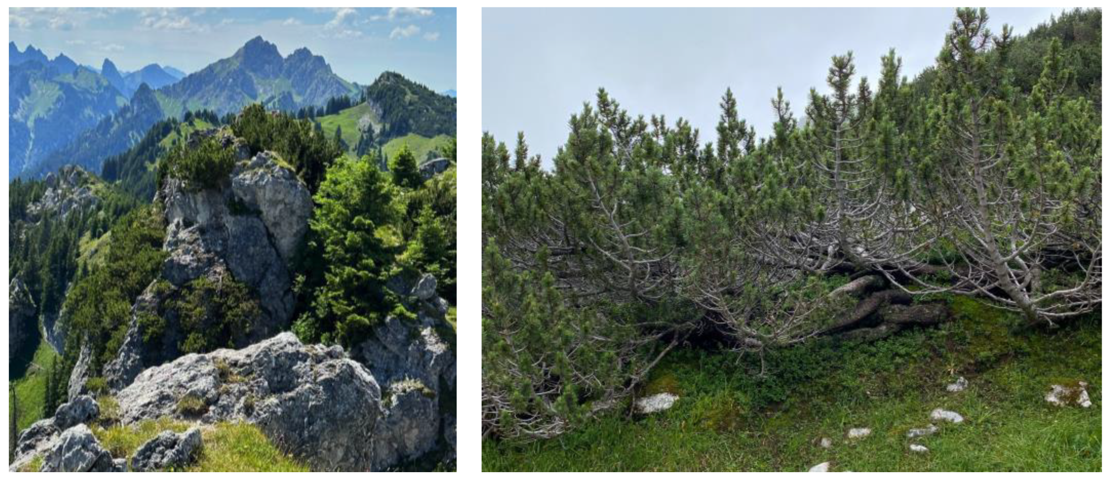
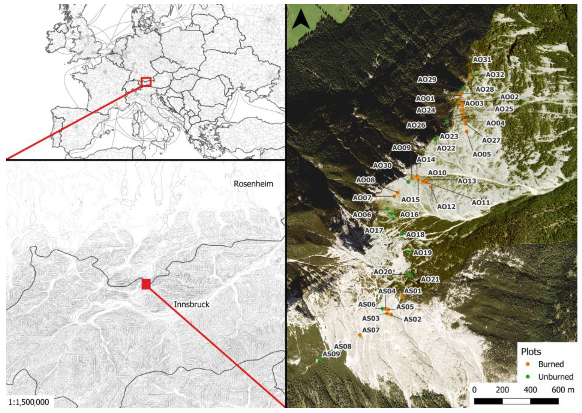
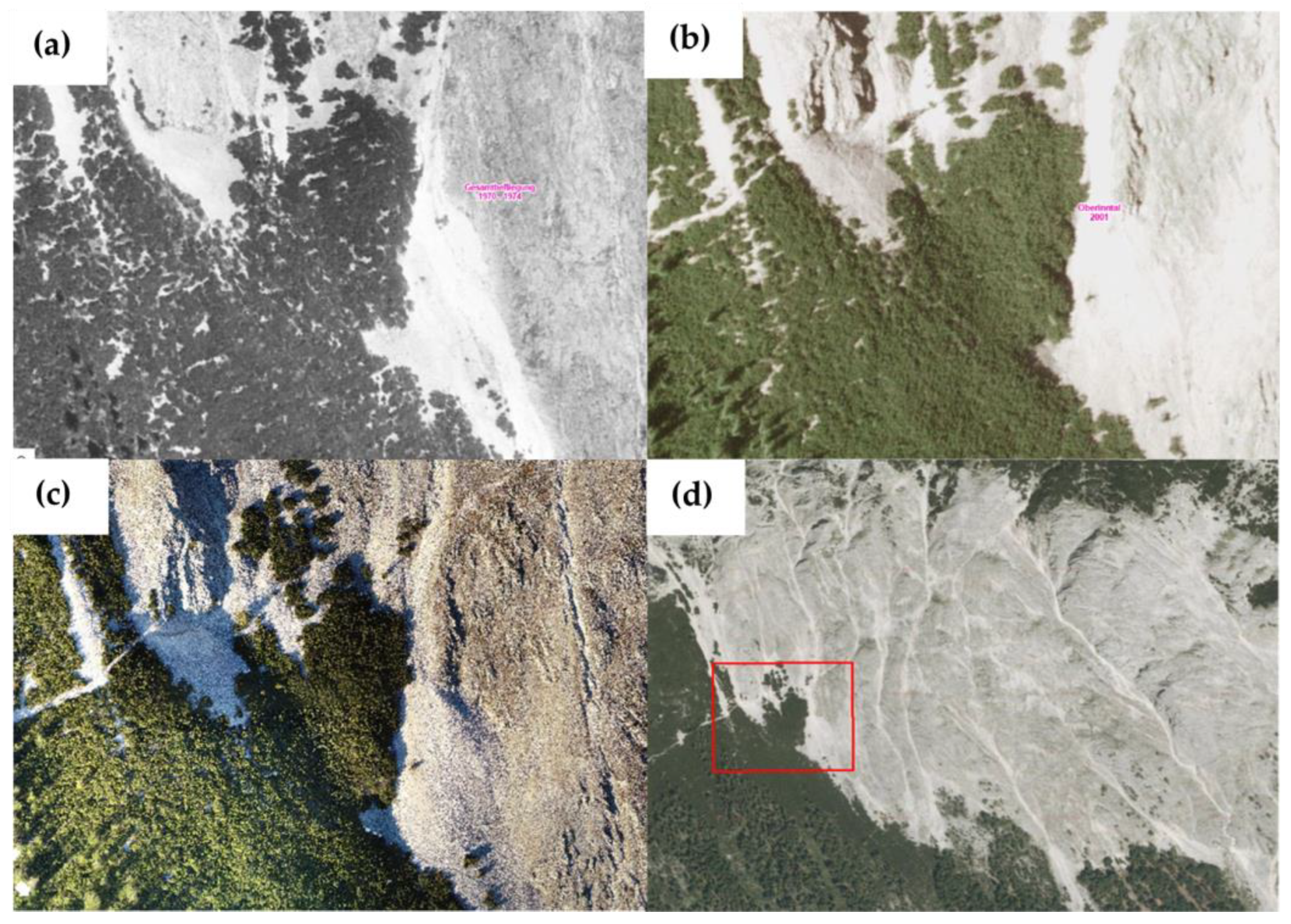
2.1. Study Site

Our study area is in the Wetterstein mountain range in the Northern Limestone Alps on the southern and eastern slopes of the Große Arnspitze (2196 m a.s.l.; 47.40° N, 11.22° W), hereafter referred to as Arnspitze. The peak is part of the Arnspitze massif located on the border between Austria and Germany, approximately 20 km northwest of Innsbruck, Austria (Figure 2). It lies between the suboceanic, cool, and humid northern edge of the European Alps and the subcontinental, warm, and dry Tyrolean Inn Valley. The average annual temperature in Innsbruck (574 m) and Mittenwald (915 m) is 8.6 °C and 6.5 °C, respectively, and near zero at the elevation of the summit. The precipitation in the area has a distinct summer maximum, characterized by frequent, intense thunderstorms, and a mean annual precipitation of 850 mm and 1430 mm in Innsbruck and Mittenwald, respectively, mirroring the expected elevational trend [10]. The mean annual precipitation for the massif is approximated between 1500 and 1750 mm [37,38]. The area is characterized by Wettersteinkalk limestone, a very pure limestone with a CaCO3 content of 95.6% [39], which slows the rate of soil formation [40] and leads to karstification. The rapid drainage of the karstified limestone coupled with the high annual evaporation results in very little available surface water and a very dry environment [37,41].
The treeline ecotone in the Northern Limestone Alps is at an elevation of 1800–2400 m, lower than in the central Swiss Alps, in part due to the cooler conditions at this northern fringe. It is characterized by a mix of open stands of Picea abies (L.) H.Karst. sometimes mixed with Larix decidua Mill. (Piceion excelsae Pawłowski et al. 1928) and P. mugo krummholz vegetation, partly forming dense thickets (Erico-Pinion mugo Leibundgut 1948). On these slopes, the krummholz vegetation is observed ranging from 1200 m to the ridges at 2050 m of elevation [10], and the rocky slopes without scree cover are occupied by small statured vegetation including dwarf shrubs such as Dryas octopetala L. and Daphne striata Tratt., graminoids, forbs, and ferns. These taxa mostly belong to Seslerion caeruleae Br.-Bl. in Br.-Bl. et Jenny, with some components of Potentillion caulescentis Br.-Bl. in Br.-Bl. et Jenny 1926, the latter presumably spread from nearby cliffs untouched by the fires.
In May 1946, the southern slope of the Arnspitze burned for about 11 days [42], consuming 5–6 ha of forest (dominated by P. abies) and approximately 100 ha of krummholz stands (dominated by P. mugo) at elevations of 1200–2000 m (Figure 3). Large swaths of the slope were left stripped of vegetation and humus soil [43]. Prior to the fire, the slope had an even cover of either P. mugo at higher elevations or forest at lower elevations (compare Figure 3a,b; see Sass, 2019). The effect of severe fires such as this on geomorphological processes has been subject to several investigations [43,44], demonstrating that the measured erosion rates on the burned, southern slope are about 10 times higher than on unburned slopes [35]. Two more, probably less severe forest fires were discovered in the area using radiocarbon dating [42]: one about 1266–1012 BCE, the other 1206–1292 CE [43].

2.2. Sampling Design

A total of 41 plots were established over the span of two years 2020–2021 during the months of July and August: 32 on the eastern slope and 9 on the southern slope of Arnspitze. Each 3 × 3 m square plot was aligned so that the upper edge was parallel to the contour line, thus pointing toward the summit or ridge. The plots were located between 1800 m and 1950 m of elevation, in areas that were safely accessible by the samplers. The positions of the plots can be seen in the map (Figure 2).
The 20 plots established in 2020 were all located in the 1946–1947 fire scar, while the 21 plots established in 2021 were partly in the fire scar, partly in the adjacent intact krummholz pine or forested stands (fire history status seen in Figure 2). A total of 26 plots were established in the fire scar, hereafter ‘burned plots’, and 15 in intact krummholz or forested sites, hereafter ‘unburned plots’. The placement of the burned plots was random within the former krummholz vegetation (taken from historical photographs), while the unburned plots were preferentially selected to be characteristic of the unaffected slope, both floristically and geophysically.

2.3. Soil Depth

To determine the soil thickness in each plot, a 1 m long metal rod with 5 cm markings was pushed into the soil until it encountered resistance. Measurements were taken using 5 cm intervals, rounding up (i.e., 12.8 cm of soil recorded as 15 cm), with shallow soils less than 5 cm in depth categorized as 2.5 cm deep. A total of five of these measurements were taken in each plot, one in the geometric center of the square and once along each diagonal, halfway between the center and the corner. To account for potential within-plot variation in soil depth, the median soil depth per plot was used for all subsequent analyses.

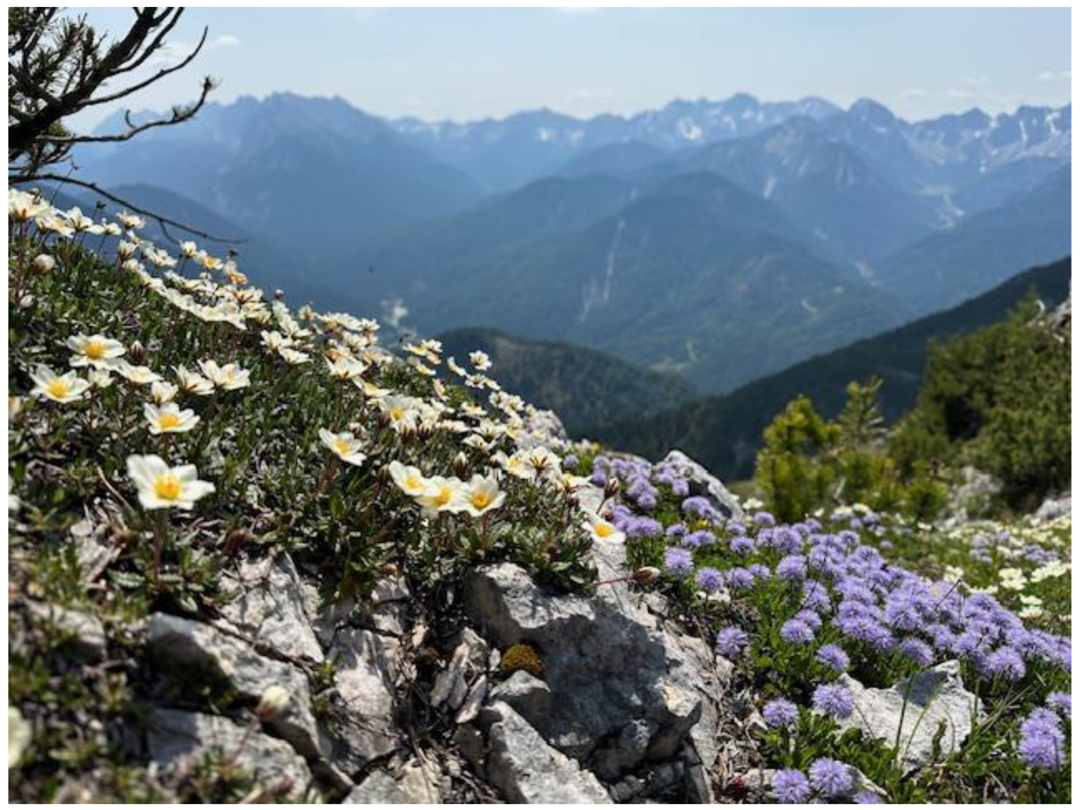
2.4. Species Composition

Vascular plant species composition and cover were assessed in each plot. Nomenclature was checked and updated according to Plants of the World Online [45]. Plant individuals were identified in the field with 186 identified to the species level, 37 only to the genus level, and 3 remained unidentified. For completeness, the entire species list was only used in the species diversity and composition analyses. Species cover in percent was assessed using the Londo scale [46], a decimal scale with an appropriate fine grain to approximate cover separate from abundance.
Ecological indicator values (EIVs) for each taxon identified to the species level were extracted from both Ellenberg and Landolt repositories [47,48]. Ellenberg EIVs are commonly used bioindicator values with a long-standing tradition in Central Europe. To balance this with our study site location (in the Alps), we also included Landolt EIVs which were formulated for Switzerland in particular and may have a more accurate representation of the indicator values for the species we observed at higher elevations. We focused on the following EIVs: temperature, light, moisture, moisture variability, nutrients, humus content, reaction/soil pH, root depth, dominance in situ, and soil aeration.
We tested whether burned and unburned sites differed in their species richness, plant community composition, species’ elevational range, and species’ ecological indicator values. We determined the alpha, beta, and gamma diversity across all plots and between fire histories (burned vs. unburned). We calculated the Shannon index [49] as the alpha diversity metric rather than the Simpson index to obtain a balanced weight of rare species, using the diversity() function in the vegan R package. We used Whittaker’s multiplicative beta diversity [50], which is determined as follows:
β = S m
where S is the number of species in a composite community, and m is the mean number of species per plot. We used the total number of unique species present in each plot as the species richness, testing the significance of this difference with a t-test using the function t_test() in R.
To evaluate whether the two types of plots were occupied by distinctly different plant communities, we compared the species composition of each plot. We tested this distinctness with a PERMANOVA using distance matrices with the function adonis2() in the vegan R package. We visualized these results with a non-multidimensional scaling (NMDS) ordination of the Bray–Curtis dissimilarity in species space using the metaMDS() function from the vegan R package.
To look at the abundance of each functional group—specifically forbs and graminoids—we tested the difference between the relative cover of each group in the burned and unburned plots with a t-test using the function t_test() in R. Relative cover was calculated as the total functional group cover in a plot divided by the total vegetative cover in the plot.

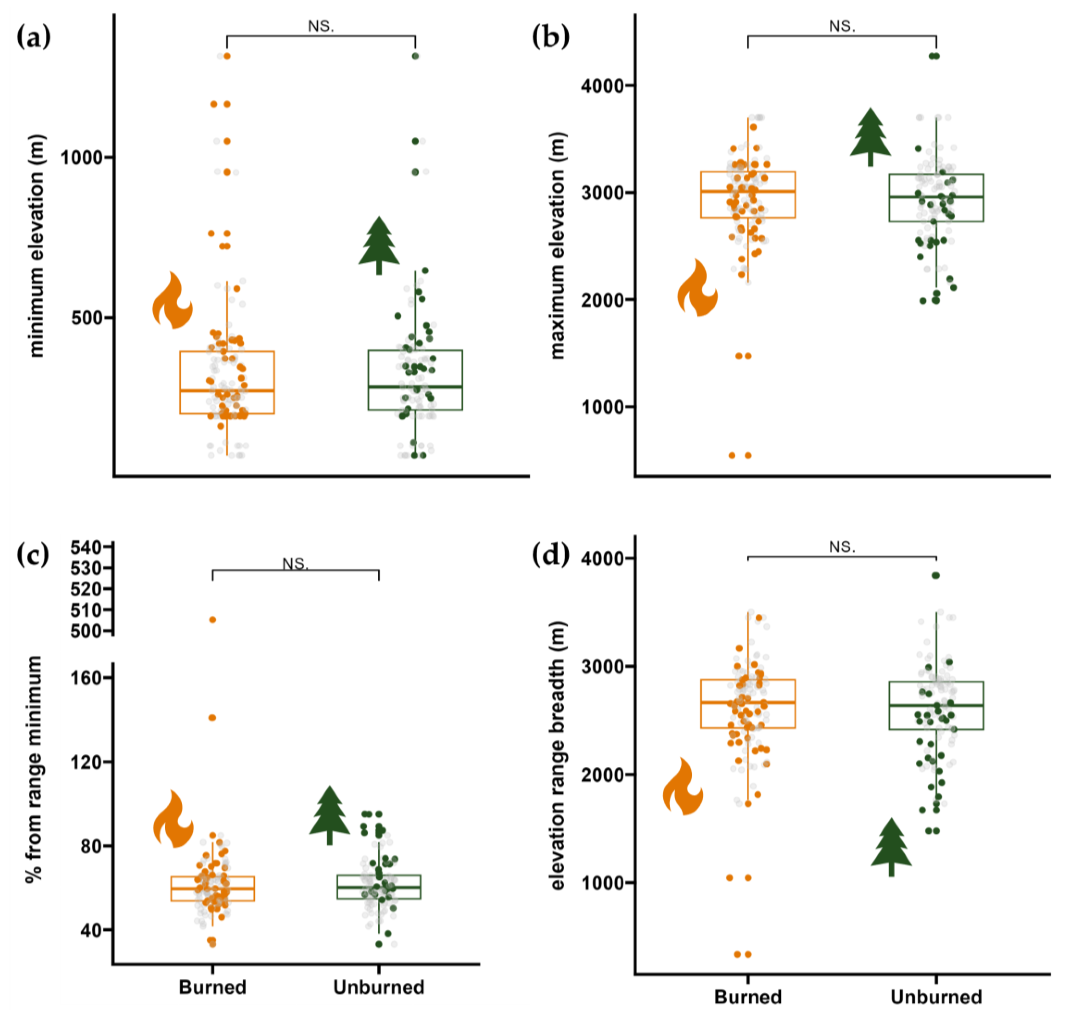
2.5. Species Elevational Ranges

To look at plant community composition as a function of elevation, we tested for a difference in the elevational range of the species present in each site type, as well as the species occurring uniquely in each. The elevational range data were obtained from the Swiss National Databank of Vascular Plants [51]. We tested for differences in maximum elevation, minimum elevation, range breadth (maximum elevation − minimum elevation), and relative elevational distance of the plot elevation from the species’ minimum elevation (1900 − minimum elevation)/range breadth) for species in each site type with a t-test using the function t_test() in R, and plotted using the helper package ggbreak [52].

2.6. Krummholz Species Recruitment

To investigate the edge changes in the present krummholz vegetation, we used freely available orthophotos provided by the Land Tyrol (© TIRIS geoinformation system), comparing pictures taken in 1974, 2001, and 2016 with UAV images taken in situ (2021).

3. Results

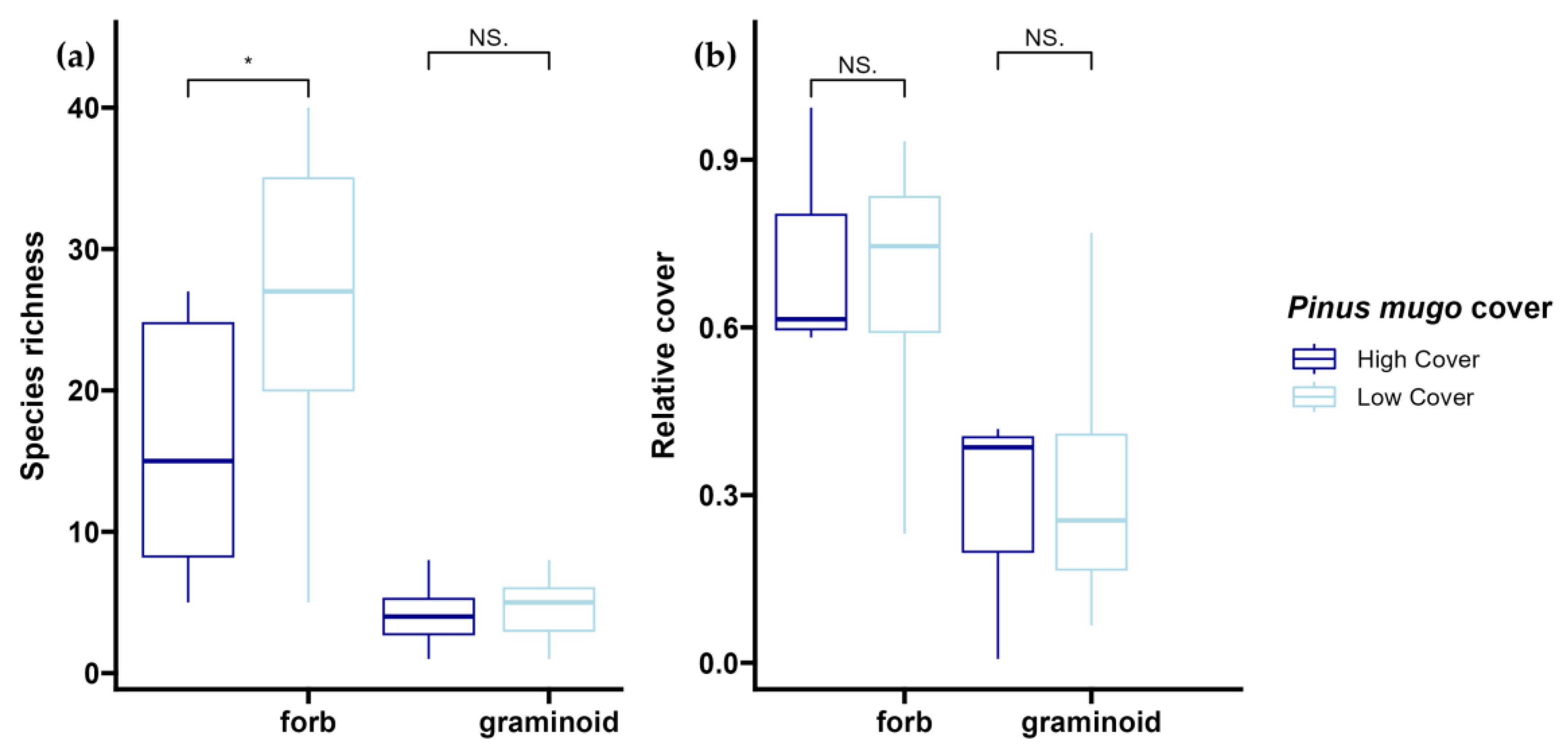
3.1. Effect of Fire on Species Composition and Plant Functional Types

Across all 41 plots, the Shannon diversity index was 2.5 ± 0.8, while the average species diversity in each plot (±SD) was 31.7 ± 10.8, beta diversity (total number of species/mean number of species per site) was 89, and gamma diversity (total number of species across all plots) was 226. Species richness varied significantly between burned and unburned plots (Figure 4b, p = 0.05), with burned plots having the greatest species richness per plot (average species/plot ± SD; 35.1 ± 8.8 vs. 25.8 ± 11.5). This pattern also carries across the alpha, beta, and gamma diversity metrics, where we see burned plots having a higher alpha Shannon index and gamma diversity but lower beta diversities, 4.2 vs. 2.8, 174 vs. 136, and 3.9 vs. 6.7, respectively.
The community composition was significantly different between the burned and unburned sites (p-value < 0.001) (Figure 4a,b). Species unique to burned plots included Carex curvula All., Ranunculus alpestris L., Rumex scutatus L., and Pedicularis kerneri Dalla Torre. Species unique to unburned plots included Alchemilla flabellata Buser, Calamagrostis varia (Schrad.) Host, and Trollius europaeus L. We observed a clustering of plots by fire history with burned plots occupying a more circular cluster than unburned plots (orange area on the NMDS, Figure 4a). This result is consistent with our earlier observation of beta and gamma diversity, indicating a more uniform community composition among burned plots than among unburned plots.
We were interested in looking at these compositional differences from a perspective of functional type—specifically, differences in forb and graminoid cover (Figure 4c). Our results indicate a significant difference in forb, graminoid, shrub, and tree cover in fire-affected slopes (Figure 4c; p < 0.001, p = 0.035, p = 0.003, p < 0.001, respectively), with relative forb and graminoid cover higher in burned plots (0.64 ± 0.20 vs. 0.20 ± 0.15 and 0.24 ± 0.12 vs. 0.12 ± 0.12, respectively). We observed an inversion of this pattern for trees and shrubs, where burned plots had hardly any tree or shrub cover compared to the 0.52 ± 0.24 and 0.16 ± 0.12 of the unburned plots (Figure 4c). The top three dominant taxa in each of these categories are highlighted in Table 1. Excluding trees, of which there were only three species present at our site, we observed two species that were dominant in both burn categories: Dryas octopetala (Figure 5) and Rhododendron hirsutum. This hints at either a slow homogenization of the communities 80 years after disturbance or the ability of these taxa to colonize the disturbed terrain in an effective manner. The large differences in mean plot covers of these taxa, coupled with the clear distinction of the communities seen in Figure 4a and their unique functional composition, provide more support to the latter suggestion.
The difference in relative cover of the functional types is likely driven by a change in species diversity after fire, where forb species richness is significantly (p = 0.005) higher in burned plots (27.9 ± 7.6) than in unburned plots (18.2 ± 10.6), as is graminoid species richness (p = 0.029) between burned plots (5.2 ± 1.7) and unburned plots (3.37 ± 2.1). However, this increase in richness does not seem to translate to a greater number of rare or endangered species, as we see slightly fewer endangered taxa present in burned plots. As seen in Figure 6, this does not insinuate a larger number of ruderal species in burned plots, and the main ruderal taxa present (C. varia) is only present in unburned plots.

3.2. Elevational Ranges of Colonizing Forbs and Graminoids

The elevational ranges of all the species present in both the burned and unburned plots were very similar (Figure 6). While the species in unburned plots had generally lower values (Figure 7a–d), we did not find a significant difference (Figure 7a–c) in minimum elevation (323 m ± 109; 324 m ± 188), maximum elevation (2948 m ± 428; 2936 m ± 387), and elevation range breadth (2625 m ± 438; 2612 m ± 404) between the species uniquely present in burned or unburned plots. These results seem to indicate that the species growing in burned areas do not have distinctly different elevational niches from those growing in unburned areas. This is further supported by the lack of significant difference in the relative distance of plot elevation from the range minima between the species in burned and unburned plots (64.0% ± 43.8; 61.5% ± 10.9), as seen in Figure 7d.
The same trends were seen in the elevational ranges of the subset of species unique to each fire history (burned vs. unburned): They did not vary significantly in minimum elevation (334 m ± 206; 334 m ± 194), maximum elevation (2853 m ± 573; 2748 m ± 417), elevation range breadth (2519 m ± 556; 2404 m ± 425), or relative elevational distance of plot location from range minima (71.9% ± 43.8; 66.9% ± 10.9). These results indicate that species colonizing the burned sites come from similar elevational ranges rather than representing a net upward shift of valley-dwelling species or a downward shift of alpine species. This is likely due to abiotic filters preventing their immigration and establishment. The 29 species unique to unburned plots include A. flabellata and T. europaeus, but also C. varia (a grass that commonly thrives after disturbance). The 47 species unique to burned plots include subalpine–alpine specialists, such as Antennaria dioica (L.) Gaertn., C. curvula, R. alpestris, Gentiana nivalis L., and P. kerneri, as well as the two outliers Asplenium obovatum ssp. billotii (F.W.Schultz) O.Bolòs, Vigo, Masalles & Ninot, and Jucus stygius L., which have documented elevational ranges of 200–450 m and 870–1470 m, respectively [53].

3.3. Effect of Fire on Community Ecologic Indicator Values

The temperature indicator value of the species supports the results found above, with inconclusive results due to the mismatch between the temperature Ellenberg and Landolt indicator values between species present in burned and unburned plots (Table 2). Similarly, the species indicative of nutrient availability (both Ellenberg and Landolt) did not vary significantly between burned and unburned plots. The species present in the burned area had significantly higher soil aeration (3.07, 2.61, p < 0.001), light (3.80, 3.46, p < 0.001), and pH (3.45, 3.28, p = 0.024) Landolt indicator values (Table 2). This contrasted with their significantly lower dominance in situ (2.36, 2.59, p < 0.001), humus content (3.00, 3.53, p < 0.001), moisture (2.75, 2.85, p = 0.043) Landolt indicator values compared to unburned plots. These results are robust to the exclusion of trees in the analyses, which, due to their very different rooting architecture and physiological requirements, could cause skewing of the data. Species present in burned plots are thus indicative of dryer, rockier, more basic soils that receive a high amount of sunlight. Taken with the inconclusive results of the temperature indicator value, this implies that the species present in these communities vary in their physical requirements rather than elevational provenance.
These results can be seen visually affecting the community composition NMDS in Figure 4a, with the burned community shifting along the light indicator value vector and the unburned community shifting along the humus content and dominance in situ indicator value vectors.

3.4. Krummholz Species Recruitment

We observed no clear evidence of tree regeneration (both individual species and combined) in the burned sites. Changes in woody canopy cover in time occurred only in unburned areas (Figure 8), visible in the filling of canopy gaps, with no discernable change in the canopy boundary. This is supported by the lack of tree cover in burned plots, where the mean tree cover per plot was less than 0.08% (Figure 4c).

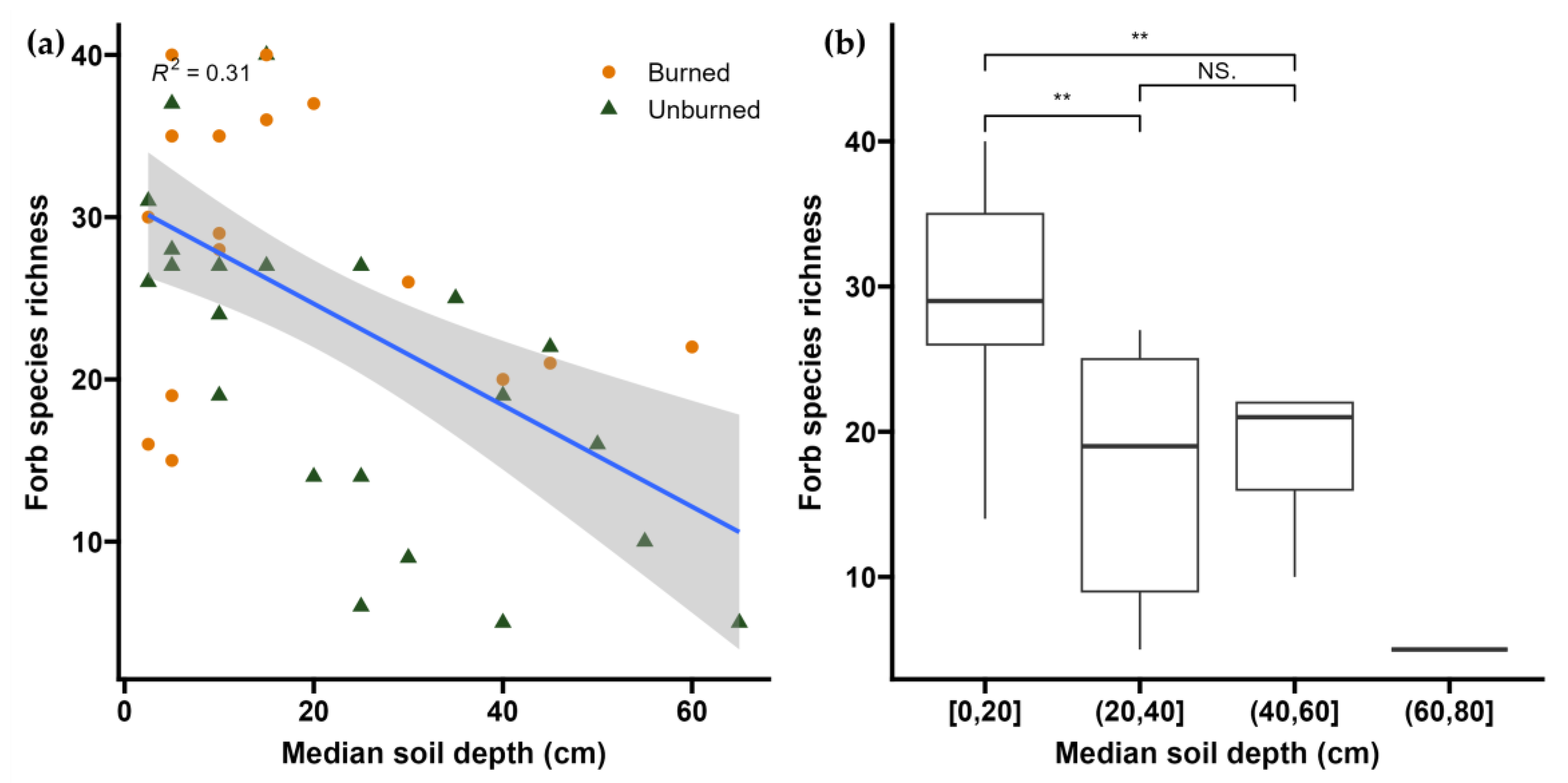
3.5. Potential Drivers of Post-Fire Regime Shift

Evidence from plot proxy data and measured environmental data suggests that the trend of increased forb diversity after fire is driven mostly by increasing light availability and partly by decreasing soil depth. As a proxy of light extinction, we recorded P. mugo cover, which was strongly related to fire history with burned plots having no cover and unburned plots an average of 32% cover (p < 0.001). Forb richness varied significantly with P. mugo cover (Figure 9a). Plots with low P. mugo cover (<25%) had significantly higher forb diversity than plots with higher cover (28.3 ± 9.0; 18.6 ± 8.8; p = 0.018), but we observed no significant variation in graminoid diversity with P. mugo cover (4.8 ± 1.9; 4.1 ± 2.2; p > 0.05). While forb richness responded to P. mugo cover, we observed no significant response in the relative cover of forbs and graminoids (Figure 9b).
Though burned and unburned plots did not vary significantly in elevation, aspect, or slope, they showed distinctly different community compositions (Figure 4a) and forb species relative cover (Figure 4c). Soil depth and variability also changed significantly as a function of fire history, with 27.4 cm ± 18.6 mean soil depth in burned plots compared to 41.2 cm ± 21.0 in unburned plots. Forb species diversity varied significantly with soil depth, with diversity decreasing with an increase in the substrate (Figure 10a). Plots with the shallowest soils had the greatest richness per plot (30.8 ± 8.2), significantly greater than the mid-depth (19.8 ± 9.0; p = 0.007) and deepest soils (21.4 ± 5.2, p = 0.009). However, we did not observe a significant difference in species diversity between the deeper two soil depths (Figure 10b).

4. Discussion

Understanding the dynamics of fire recovery in the subalpine and alpine belt is becoming increasingly important as these zones are becoming hotspots for change [18,20] and priorities for biodiversity conservation [34]. The long-term fire recovery of subalpine krummholz—including evidence of arrested succession—is not well studied and is an issue that needs to be monitored to help address pressing ecological and safety concerns in the mountains. These studies need to be held in the context of changing climate and disturbance regimes [54], shifting snow [20,21] and growing periods [20], as well as water availability affected by changing temperature and summer precipitation regimes [19], increased fire risk and natural fire occurrence [55], and the subsequent risk of soil erosion [15,16] and avalanche occurrence [17]. Critically, these environmental changes may have already altered baseline climatic conditions necessary for the complete post-fire recovery of subalpine systems and the recruitment of currently absent woody vegetation. These halted successional subalpine krummholz dynamics can trigger a regime shift to open, high-elevation tundra [31,56] generating novel habitats for biodiversity of high nature value.
In the Northern Limestone Alps, fire seems to have a distinct impact on the plant community in the krummholz zone: entirely removing woody, krummholz vegetation—here P. mugo—and shifting the community toward a herbaceously dominated, species-rich, subalpine grassland. This is a more homogeneous community, as seen by the lower beta diversity and closer clustering of the burned plots (compare Figure 4a). This homogenization toward species-rich subalpine grassland or tundra has also been observed in other studies, where previously krummholz or shrubby subalpine vegetation gained richness while losing woody dominance and spatial heterogeneity after fire [29,31]. This plant species diversity is gained mostly through forb and graminoid diversity, which is significantly higher in burned plots than in unburned plots (Figure 4c). The ecological indicator values of the species present in the communities also indicate a shift toward plant species that are associated with drier, brighter sites with shallower soils in burned areas (Table 2), likely driven by the removal of the P. mugo biotic filter by fire, providing more light and freeing substrate for potential herbaceous colonizers.
Though this shift in species composition could also open niches for lowland disturbance specialists or ruderal invasives [57,58], we did not see a variation in the elevation ranges of the species between burned and unburned sites (Figure 6) or the presence of “weeds” in burned plots (Figure 4). By contrast, certain alpine specialist species were found only in burned plots, such as C. curvula, P. kerneri, Plantago atrata Hoppe, Veronica fruticans Jacq., and Poa supina Schrad., while others such as Festuca alpina Suter, D. striata, and Veronica aphylla L. were observed growing in both burned and unburned plots. This, coupled with other species found only in unburned sites such as Gentiana acaulis L., Gentiana bavarica L., and Globularia nudicaulis L., which appeared to be unable to colonize the burned sites, seems to indicate that the new community is not composed of species novel to these elevations, rather a new grouping of species already present at these elevations.
The homogeneity and richness of the post-fire communities give us a potential insight into the duration of recovery. Our survey was conducted just under 80 years after the latest occurrence of fire on these slopes. Though these systems are known to take decades or even centuries to recover [3], the complete lack of P. mugo seedlings indicates that the herbaceous vegetative recovery is temporally different from that of woody species. This observation is consistent with other studies that observed little to no woody species regeneration within the first half-century after fire and reconstructed a recovery time of over 150 years for the restocking of woody krummholz vegetation [29,30,31]. However, sites recovering from fire in subalpine forests in the Valais in the Central Alps see a significant rewooding after only 10 years, with aspect playing a significant role in the successful reestablishment of seedlings: northern aspects had a 17-fold increase in stem density compared to southern aspects 19 years after fire [14,33].
Potential drivers of this arrested succession could be three-fold. Here, we have shown a lack of tree seedling recruitment in burned areas (Figure 8), likely due to prolonged periods with frozen soil and the potential of extreme temperatures, in line with Walker et al. 2010 [59]. We have also uncovered that limited substrate availability (in the form of soil depth) is a key driver of forb diversity and can thus be key to supporting a viable herbaceous recovery while preventing the establishment of P. mugo seedlings [60]. The third factor, not discussed in this paper, that prevents the establishment of seedlings could be linked to browsing or grazing pressure from ungulates [61].
Climate change is bringing other abiotic stressors into the picture, though with predictions for the Eastern Alps indicating increases in summer and autumn temperatures as well as in the frequency and severity of heatwaves [62,63]. Beniston et al. (2004) [62] forecast a shift in precipitation expected in the northern Eastern Alps from large summer events to spring and autumn rainfall. Combined with forecasted earlier snowmelt dates [20,21,64], these stressors will expose vegetation to longer, likely more intense, dry conditions, leading to increased fire risk in much of this zone [10,22]. While in the past, fire management strategies may not have been considered necessary in these areas, the projected increase in fire risk coupled with the long-term impacts of fire on vegetation analyzed in this study, as well as on other abiotic factors [10,11,12,13,14,15,16,17,18], necessitates bringing this management strategy to the forefront.

5. Conclusions

Albeit potentially temporary, these post-fire subalpine herbaceous communities are vital for the protection of diversity in our mountains and can be useful to help mitigate the negative effects of our changing alpine climates by acting as refugia for an array of threatened and endangered species. To further understand the dynamics of recovery in these systems and decipher whether the community shift we have observed is a plateau in the successional return to the previously woody krummholz vegetation or rather an alternate subalpine grassland steady state, it is important to look at the system as a whole—combining biotic and abiotic factors and placing this one site within the context of many others. Studies in other such sites are scarce (but see [14] for more forested sites in the European Alps and [30,31] for sites in Japan and the USA, respectively), and a thorough analysis of the abiotic elements present in these extreme post-fire habitats is lacking (see [42]). Given this gap, we recommend further investigation into understanding the causes of P. mugo regeneration failure in these scenarios with a focus on micrometeorological factors and seed, seedling, and sapling physiology, as well as the impact of ungulate browsing. Management of these areas should include these results in their assessment of new conservation goals, making sure to balance the ability of fire to create more open systems with the likelihood that these changes may be permanent.

Author Contributions

Conceptualization, A.J. and O.S.; field data collection, T.D., J.H., A.J., M.W. and P.W.; formal analysis, M.D.G.; writing—original draft preparation, M.D.G. and A.J.; writing—review and editing, M.D.G., T.D., A.J., O.S., M.W. and P.W. All authors have read and agreed to the published version of the manuscript.

Funding

We acknowledge a small grant by the Bayreuth Center of Ecology and Environmental Research (BayCEER) at the University of Bayreuth, Germany and the Open Access Publishing Fund of the University of Bayreuth.

Institutional Review Board Statement

Not applicable.

Data Availability Statement

Data will be made available upon request.

Conflicts of Interest

The authors declare no conflicts of interest. The funders had no role in the design of the study; in the collection, analyses, or interpretation of data; in the writing of the manuscript; or in the decision to publish the results.

References

  1. Breckle, S.-W.; Lawlor, G.; Lawlor, D.W.; Walter, H.; Breckle, S.-W.; Walter, H. Walter’s Vegetation of the Earth: The Ecological Systems of the Geo-Biosphere, 4th ed.; Springer: Berlin/Heidelberg, Germany, 2002; ISBN 978-3-540-43315-6. [Google Scholar]
  2. Genries, A.; Muller, S.D.; Mercier, L.; Bircker, L.; Carcaillet, C. Fires Control Spatial Variability of Subalpine Vegetation Dynamics during the Holocene in the Maurienne Valley (French Alps). Écoscience 2009, 16, 13–22. [Google Scholar] [CrossRef]
  3. Sass, O.; Heel, M.; Leistner, I.; Stöger, F.; Wetzel, K.; Friedmann, A. Disturbance, Geomorphic Processes and Recovery of Wildfire Slopes in North Tyrol. Earth Surf. Process. Landf. 2012, 37, 883–894. [Google Scholar] [CrossRef]
  4. Carcaillet, C.; Ali, A.A.; Blarquez, O.; Genries, A.; Mourier, B.; Bremond, L. Spatial variability of fire history in subalpine forests: From natural to cultural regimes. Ecoscience 2009, 16, 1–12. [Google Scholar] [CrossRef]
  5. Zumbrunnen, T.; Menéndez, P.; Bugmann, H.; Conedera, M.; Gimmi, U.; Bürgi, M. Human impacts on fire occurrence: A case study of hundred years of forest fires in a dry alpine valley in Switzerland. Reg. Environ. Chang. 2012, 12, 935–949. [Google Scholar] [CrossRef]
  6. Leys, B.; Carcaillet, C. Subalpine fires: The roles of vegetation, climate and, ultimately, land uses. Clim. Chang. 2016, 135, 683–697. [Google Scholar] [CrossRef]
  7. Higuera, P.E.; Brubaker, L.B.; Anderson, P.M.; Hu, F.S.; Brown, T.A. Vegetation mediated the impacts of postglacial climate change on fire regimes in the south-central Brooks Range, Alaska. Ecol. Monogr. 2009, 79, 201–219. [Google Scholar] [CrossRef]
  8. Leys, B.; Finsinger, W.; Carcaillet, C. Historical range of fire frequency is not the Achilles’ heel of the Corsican black pine ecosystem. J. Ecol. 2014, 102, 381–395. [Google Scholar] [CrossRef]
  9. Tinner, W.; Conedera, M.; Ammann, B.; Lotter, A.F. Fire Ecology North and South of the Alps since the Last Ice Age. Holocene 2005, 15, 1214–1226. [Google Scholar] [CrossRef]
  10. Sass, O.; Wetzel, K.-F.; Friedmann, A. Landscape Dynamics of Sub-Alpine Forest Fire Slopes in the Northern Alps-Preliminary Results. Z. Für Geomorphol. Suppl. 2006, 142, 207–227. [Google Scholar]
  11. Moser, B.; Gimmi, U.; Wohlgemuth, T. Ausbreitung Des Erdbeerspinats Blitum Virgatum Nach Dem Waldbrand von Leuk, Wallis (2003). Bot. Helv. 2006, 116, 179–207. [Google Scholar] [CrossRef]
  12. Moser, B.; Temperli, C.; Schneiter, G.; Wohlgemuth, T. Potential Shift in Tree Species Composition after Interaction of Fire and Drought in the Central Alps. Eur. J. For. Res. 2010, 129, 625–633. [Google Scholar] [CrossRef]
  13. Wohlgemuth, T.; Hester, C.; Jost, A.-R.; Wasem, U.; Moser, B. Dynamik Der Wiederbewaldung Im Waldbrandgebiet von Leuk (Wallis)|Recruitment Dynamics Following the Forest Fire near Leuk (Valais). Schweiz. Z. Forstwes. 2010, 161, 450–459. [Google Scholar] [CrossRef]
  14. Wohlgemuth, T.; Moser, B. Zehn Jahre Vegetationsdynamik Auf Der Waldbrandfläche von Leuk (Wallis). Schweiz. Z. Forstwes. 2018, 169, 279–289. [Google Scholar] [CrossRef]
  15. Shakesby, R.A. Post-Wildfire Soil Erosion in the Mediterranean: Review and Future Research Directions. Earth-Sci. Rev. 2011, 105, 71–100. [Google Scholar] [CrossRef]
  16. Mandrone, G.; Vacha, D.; Chicco, J. Post-Wildfire Erosion Rates and Triggering of Debris Flows: A Case Study in Susa Valley (Bussoleno). E3S Web Conf. 2023, 415, 1–4. [Google Scholar] [CrossRef]
  17. Sass, O.; Heel, M.; Hoinkis, R.; Wetzel, K.-F. A Six-Year Record of Debris Transport by Avalanches on a Wildfire Slope (Arnspitze, Tyrol). Z. Geomorphol. 2010, 54, 181–193. [Google Scholar] [CrossRef]
  18. Seidl, R.; Thom, D.; Kautz, M.; Martin-Benito, D.; Peltoniemi, M.; Vacchiano, G.; Wild, J.; Ascoli, D.; Petr, M.; Honkaniemi, J.; et al. Forest Disturbances under Climate Change. Nat. Clim. Chang. 2017, 7, 395–402. [Google Scholar] [CrossRef] [PubMed]
  19. Auer, I.; Böhm, R.; Jurkovic, A.; Lipa, W.; Orlik, A.; Potzmann, R.; Schöner, W.; Ungersböck, M.; Matulla, C.; Briffa, K.; et al. HISTALP—Historical Instrumental Climatological Surface Time Series of the Greater Alpine Region. Int. J. Climatol. 2007, 27, 17–46. [Google Scholar] [CrossRef]
  20. Gobiet, A.; Kotlarski, S.; Beniston, M.; Heinrich, G.; Rajczak, J.; Stoffel, M. 21st Century Climate Change in the European Alps—A Review. Sci. Total Environ. 2014, 493, 1138–1151. [Google Scholar] [CrossRef]
  21. Klein, G.; Vitasse, Y.; Rixen, C.; Marty, C.; Rebetez, M. Shorter Snow Cover Duration since 1970 in the Swiss Alps Due to Earlier Snowmelt More than to Later Snow Onset. Clim. Chang. 2016, 139, 637–649. [Google Scholar] [CrossRef]
  22. Cansler, C.A.; McKenzie, D.; Halpern, C.B. Area Burned in Alpine Treeline Ecotones Reflects Region-Wide Trends. Int. J. Wildland Fire 2016, 25, 1209. [Google Scholar] [CrossRef]
  23. Dupire, S.; Curt, T.; Bigot, S.; Fréjaville, T. Vulnerability of Forest Ecosystems to Fire in the French Alps. Eur. J. For. Res. 2019, 138, 813–830. [Google Scholar] [CrossRef]
  24. Moris, J.V.; Vacchiano, G.; Ravetto Enri, S.; Lonati, M.; Motta, R.; Ascoli, D. Resilience of European Larch (Larix decidua Mill.) Forests to Wildfires in the Western Alps. New For. 2017, 48, 663–683. [Google Scholar] [CrossRef]
  25. Maringer, J.; Ascoli, D.; Küffer, N.; Schmidtlein, S.; Conedera, M. What Drives European Beech (Fagus sylvatica L.) Mortality after Forest Fires of Varying Severity? For. Ecol. Manag. 2016, 368, 81–93. [Google Scholar] [CrossRef]
  26. Frejaville, T.; Curt, T.; Carcaillet, C. Bark Flammability as a Fire-Response Trait for Subalpine Trees. Front. Plant Sci. 2013, 4, 466. [Google Scholar] [CrossRef] [PubMed]
  27. Körner, C. The Cold Range Limit of Trees. Trends Ecol. Evol. 2021, 36, 979–989. [Google Scholar] [CrossRef] [PubMed]
  28. Jentsch, A.; White, P. A Theory of Pulse Dynamics and Disturbance in Ecology. Ecology 2019, 100, e02734. [Google Scholar] [CrossRef] [PubMed]
  29. Douglas, G.W.; Ballard, T.M. Effects of Fire on Alpine Plant Communities in the North Cascades, Washington. Ecology 1971, 52, 1058–1064. [Google Scholar] [CrossRef]
  30. Tomback, D.F. Post-Fire Regeneration of Krummholz Whitebark Pine: A Consequence Of Nutcracker Seed Caching. Madroño 1986, 33, 100–110. [Google Scholar]
  31. Takahashi, K. Damage of Alpine Vegetation by the 2009 Fire on Mt. Shirouma, Central Japan: Comparison between Herbaceous Vegetation and Pinus Pumila Scrub. Landsc. Ecol. Eng. 2012, 8, 123–128. [Google Scholar] [CrossRef]
  32. Kalas, M.M.; Berg, C. Regeneration of High Montane Plant Communities in the “Nationalpark Kalkalpen” (Northern Alps) after Fire Events. In Proceedings of the 5th Symposium for Research in Protected Areas, Mittersill, Austria, 10–12 June 2013. [Google Scholar]
  33. Gauye, C.; Bernard, C.; Moser, B.; Rigling, A.; Wohlgemuth, T. L’importance de l’exposition Sur Le Reboisement Suite à Deux Incendies de Forêt En Valais. Schweiz. Z. Forstwes. 2023, 174, 238–242. [Google Scholar] [CrossRef]
  34. Geppert, C.; Bertolli, A.; Prosser, F.; Marini, L. Red-Listed Plants Are Contracting Their Elevational Range Faster than Common Plants in the European Alps. Proc. Natl. Acad. Sci. USA 2023, 120, e2211531120. [Google Scholar] [CrossRef] [PubMed]
  35. Schweiger, A.-K.; Nopp-Mayr, U.; Zohmann, M. Small-Scale Habitat Use of Black Grouse (Tetrao tetrix L.) and Rock Ptarmigan (Lagopus Muta Helvetica Thienemann) in the Austrian Alps. Eur. J. Wildl. Res. 2012, 58, 35–45. [Google Scholar] [CrossRef]
  36. Scridel, D.; Tenan, S.; Brambilla, M.; Celva, R.; Forti, A.; Fracasso, I.; Volcan, G.; Dorigatti, E.; Anderle, M.; Marchesini, A. Early-Succession Secondary Forests Following Agropastoral Abandonment Are Key Winter Habitats for the Conservation of a Priority Bird in the European Alps. Eur. J. For. Res. 2022, 141, 1029–1043. [Google Scholar] [CrossRef]
  37. Baumgartner, A.; Reichel, E.; Weber, G. Der Wasserhaushalt Der Alpen: Niederschlag, Verdunstung, Abfluß u. Gletscherspende Im Gesamtgebiet d. Alpen Im Jahresdurchschnitt Für d. Normalperiode 1931–1960; Mit 68 Tab; R. Oldenbourg: München, Germany, 1983; ISBN 978-3-486-27251-2. [Google Scholar]
  38. Schiechtl, H.; Stern, R.; Meisel, K. Karte Der Aktuellen Vegetation von Tirol 1:100,000. XI. Teil: Blatt 2 Lechtaler Alpen-Wetterstein. Grenoble 1987, XXX, 25–48. [Google Scholar]
  39. Hüttl, C. Steuerungsfaktoren und Quantifizierung der Chemischen Verwitterung auf dem Zugspitzplatt (Wettersteingebirge, Deutschland): Mit 77 Tabellen; Münchener Geographische Abhandlungen Reihe B; Geobuch-Verl: München, Germany, 1999; ISBN 978-3-925308-51-2. [Google Scholar]
  40. Sass, O.; Haas, F.; Schimmer, C.; Heel, M.; Bremer, M.; Stöger, F.; Wetzel, K. Impact of Forest Fires on Geomorphic Processes in the Tyrolean Limestone Alps. Geogr. Ann. Ser. Phys. Geogr. 2012, 94, 117–133. [Google Scholar] [CrossRef]
  41. Korch, O.; Friedmann, A. Vegetation und Vegetationsdynamik auf dem Zugspitzplatt (Bayerische Alpen) Natur- und Kulturlandschaft im hochalpinen Raum als Produkt natürlicher, anthropogener und zoogener Einflüsse. Polarforschung 2016, 86, 35–45. [Google Scholar] [CrossRef]
  42. Sass, O. Waldbrände in den Nordtiroler Kalkalpen: Verbreitung-Geschichte-Regeneration; Innsbrucker Geographische Studien; Geographie Innsbruck: Innsbruck, Austria, 2019; ISBN 978-3-901182-44-0. [Google Scholar]
  43. Heel, M. Waldbrände in den Nördlichen Kalkalpen: Raumzeitliche Verteilung und Beispiele Lokaler Auswirkungen. Ph.D. Thesis, Universität Augsburg, Augsburg, Germany, 2016. [Google Scholar]
  44. Stine, M.B.; Butler, D.R. Effects of Fire on Geomorphic Factors and Seedling Site Conditions within the Alpine Treeline Ecotone, Glacier National Park, MT. Catena 2015, 132, 37–44. [Google Scholar] [CrossRef]
  45. Plants of the World Online. Facilitated by the Royal Botanic Gardens, Kew. Available online: http://www.plantsoftheworldonline.org/ (accessed on 17 May 2024).
  46. Londo, G. The decimal scale for releves of permanent quadrats. Vegetatio 1976, 33, 61–64. [Google Scholar] [CrossRef]
  47. Ellenberg, H.; Weber, H.E.; Düll, R.; Wirth, V.; Werner, W. Zeigerwerte von Pflanzen in Mitteleuropa; Scripta Geobotanica; 3. Durchgesehene Auflage.; Verlag Erich Goltze GmbH & Co KG: Göttingen, Germany, 2001; ISBN 978-3-88452-518-0. [Google Scholar]
  48. Landolt, E. Flora Indicativa: Ökologische Zeigerwerte und Biologische Kennzeichen zur Flora der Schweiz und der Alpen; 2. Völlig Neu Bearbeitete und Erweiterte Aufl.; Haupt: Bern, Switzerland, 2010; ISBN 978-3-258-07461-0. [Google Scholar]
  49. Hill, M.O. Diversity and evenness: A unifying notation and its consequences. Ecology 1973, 54, 427–473. [Google Scholar] [CrossRef]
  50. Whittaker, R.H. Evolution and measurement of species diversity. Taxon 1972, 21, 213–251. [Google Scholar] [CrossRef]
  51. Jutzi, M.; Vilpert, M.; Juillerat, P.; Eggenberg, S. Swiss National Databank of Vascular Plants. Version 1.15. Swiss National Biodiversity Data and Information Centres—Infospecies.ch. 2023. Occurrence Dataset. Accessed via GBIF.org. Available online: https://doi.org/10.15468/7jffp3 (accessed on 1 December 2023).
  52. Xu, S.; Chen, M.; Feng, T.; Zhan, L.; Zhou, L.; Yu, G. Use Ggbreak to Effectively Utilize Plotting Space to Deal with Large Datasets and Outliers. Front. Genet. 2021, 12, 774846. [Google Scholar] [CrossRef]
  53. Hess, H.E.; Landolt, E.; Hirzel, R. Flora der Schweiz und Angrenzender Gebiete; 1: Pteridophyta bis Caryophyllaceae; 2. Durchges. Aufl.; Birkhäuser: Basel Stuttgart, Germany, 1976; ISBN 978-3-7643-0843-8. [Google Scholar]
  54. Wohlgemuth, T.; Jentsch, A.; Seidl, R. Disturbance Ecology; Springer Nature: Berlin/Heidelberg, Germany, 2022; Volume 32, ISBN 3-030-98756-6. [Google Scholar]
  55. Wastl, C.; Schunk, C.; Leuchner, M.; Pezzatti, G.B.; Menzel, A. Recent Climate Change: Long-Term Trends in Meteorological Forest Fire Danger in the Alps. Agric. For. Meteorol. 2012, 162, 1–13. [Google Scholar] [CrossRef]
  56. Daskalova, G.N.; Myers-Smith, I.H.; Bjorkman, A.D.; Blowes, S.A.; Supp, S.R.; Magurran, A.E.; Dornelas, M. Landscape-Scale Forest Loss as a Catalyst of Population and Biodiversity Change. Science 2020, 368, 1341–1347. [Google Scholar] [CrossRef] [PubMed]
  57. Haider, S.; Palm, S.; Bruelheide, H.; de Villemereuil, P.; Menzel, A.; Lachmuth, S. Disturbance and Indirect Effects of Climate Warming Support a Plant Invader in Mountains. Oikos 2022, 2022, e08783. [Google Scholar] [CrossRef]
  58. Lembrechts, J.J.; Pauchard, A.; Lenoir, J.; Nuñez, M.A.; Geron, C.; Ven, A.; Bravo-Monasterio, P.; Teneb, E.; Nijs, I.; Milbau, A. Disturbance is the key to plant invasions in cold environments. Proc. Natl. Acad. Sci. USA 2016, 113, 14061–14066. [Google Scholar] [CrossRef] [PubMed]
  59. Walker, L.R.; Wardle, D.A.; Bardgett, R.D.; Clarkson, B.D. The Use of Chronosequences in Studies of Ecological Succession and Soil Development. J. Ecol. 2010, 98, 725–736. [Google Scholar] [CrossRef]
  60. Šenfeldr, M.; Treml, V. Which Generative Reproduction Characteristics Determine Successful Establishment of the Subalpine Shrub Pinus mugo? J. Veg. Sci. 2020, 31, 403–415. [Google Scholar] [CrossRef]
  61. Simon, A.; Katzensteiner, K.; Gratzer, G. Drivers of Forest Regeneration Patterns in Drought Prone Mixed-Species Forests in the Northern Calcareous Alps. For. Ecol. Manag. 2019, 453, 117589. [Google Scholar] [CrossRef]
  62. Beniston, M. The 2003 heat wave in Europe: A shape of things to come? An analysis based on Swiss climatological data and model simulations. Geophys. Res. Lett. 2004, 31, L02202. [Google Scholar] [CrossRef]
  63. Beniston, M. August 2005 intense rainfall event in Switzerland: Not necessarily an analog for strong convective events in a greenhouse climate. Geophys. Res. Lett. 2006, 33, L05701. [Google Scholar] [CrossRef]
  64. Beniston, M.; Keller, F.; Goyette, S. Snow pack in the Swiss Alps under changing climatic conditions: An empirical approach for climate impacts studies. Theoret. Appl. Climatol. 2003, 74, 19–31. [Google Scholar] [CrossRef]
Figure 1. Treeline landscapes with krummholz patches forming woody patches on rocky outcrops, i.e., Ammergebirge, or dense thickets on shallow soils, i.e., Wetterstein (@A.Jentsch).
Diversity 16 00366 g001
Figure 2. Location of the Arnspitze massif, Germany (left) and of the 41 sampling plots. Source: ESRI World Imagery.
Diversity 16 00366 g002
Figure 3. (a) Pre-fire eastern slope of the Arnspitze (Wetterstein, Northern Limestone Alps) harboring subalpine forest and krummholz vegetation (@R.Rischreiter, before 1946) versus (b) post-fire Eastern slope of the Arnspitze 80 years later devoid of woody vegetation exposing bare rock (@A.Jentsch in 2023).
Diversity 16 00366 g003
Figure 4. Analysis of community composition of the burned and unburned plots: (a) NMDS ordination using Bray–Curtis dissimilarity of plots in species space. Convex hulls show burned (orange) and unburned (green) plots. Blue vectors are the Landolt ecological indicator values of the species in the analysis. (b) Comparison of species richness and (c) comparison of the relative cover of functional types (forb, graminoid, and tree) of plots by fire history (orange: burned, green: unburned). Significance levels indicated by “***” = 0.001, “**” = 0.01, and “*” = 0.05.
Diversity 16 00366 g004
Figure 5. Characteristic open patch krummholz ecotone species, Dryas octopetala and Globularia cordifolia, with Pinus mugo in the background, covering shallow soil in the Northern Limestone Alps (@A.Jentsch in 2023).
Diversity 16 00366 g005
Figure 6. Elevation ranges of taxa identified to the species level found uniquely in burned plots (orange), unburned plots (green), or common to both (gray). The red dotted line indicates the elevation of the sampling plots.
Diversity 16 00366 g006
Figure 7. (ad) Comparison of range extents of all species found in the burned and unburned plots; species unique to each fire history are in orange and green, respectively, while species common to both fire histories are in gray: (a) minimum limit of each species present; (b) maximum limit of each species; (d) the elevation extent (calculated as maximum elevation − minimum elevation) for each species; (c) location and relative elevational distance of the plot (1900 m) from the minimum elevation limit of each species (calculated as (1900 − minimum elevation)/elevation extent); NS indicates non-significant.
Diversity 16 00366 g007
Figure 8. Patterns of P. mugo growth on a section of the southern slope of the Arnspitze at approximately 1600 m a.s.l. in (a) 1974, (b) 2001, (c) 2020, and (d) overview (section of interest outlined in red) data: (a,b,d) orthophotos (LBA.TIROL.GV.AT, DATA.TIROL.GV.AT), (c) orthomosaic created from project UAV data.
Diversity 16 00366 g008
Figure 9. (a) Comparison of plots with high vs. low Pinus mugo cover in species richness and (b) relative cover by the functional group of plots grouped by P. mugo cover class. Significance levels indicated by “*” = 0.05; NS indicates non-significant.
Diversity 16 00366 g009
Figure 10. Forb species richness by (a) median soil depth and (b) median soil depth class. Significance levels indicated by “**” = 0.01; NS indicates non-significant.
Diversity 16 00366 g010
Table 1. Top three dominant taxa of each functional type (forb, graminoid, shrub, and tree) by mean plot cover (percentage) in burned and unburned plots.
ForbGraminoidShrubTree
BurnedD. octopetala
(14.4%)
Nardus stricta L.
(11.7%)
Rhododendron hirsutum L.
(2%)
P. abies
(5.2%)
Crepis foetida L.
(11%)
Carex humilis Leyss.
(5.75%)
Vaccinium vitis-idea L.
(1.3%)
L. decidua
(3%)
Gymnocarpium robertianum (Hoffm.) Newman
(10%)
C. curvula
(4.85%)
Vaccinium myrtillus L.
(0.7%)
P. mugo
(1%)
UnburnedViola biflora L.
(9.1%)
Alpagrostis alpina (Scop.) P.M. Peterson, Romasch., Soreng & Sylvester
(20.0%)
Rhododendron
ferrugineum L.
(15.2%)
P. mugo
(54.2%)
Erica carnea L.
(7.3%)
Carex sempervirens Vill.
(19.6%)
R. hirsutum
(12.3%)
P. abies
(23.1%)
D. octopetala
(5.4%)
Luzula campestris (L.) DC.
(15.0%)
Vaccinium uliginosum L.
(6.8%)
L. decidua
(14.3%)
Table 2. Table of significance in variation in Ellenberg and Landolt indicator values for communities in burned and unburned plots. Significance levels indicated by “****” = 0.0001, “**” = 0.01, and “*” = 0.05; ns and grayed-out rows indicate non-significant results.
IndicatorSourceMean BurnedMean UnburnedStatisticp-ValueSignificance
AerationLandolt3.072.615.09<<0.001****
Dominance in situLandolt2.362.59−3.99<<0.001****
Humus contentLandolt3.003.53−6.53<<0.001****
LightEllenberg7.446.915.50<<0.001****
Landolt3.803.465.74<<0.001****
MoistureEllenberg4.714.93−2.440.015*
Landolt2.752.85−2.020.043*
Moisture variabilityLandolt1.501.57−1.450.148ns
NutrientsEllenberg2.963.02−0.570.571ns
Landolt2.292.280.120.902ns
Reaction/Soil pHEllenberg6.616.122.810.005**
Landolt3.453.282.270.024*
Root depthLandolt1.821.90−1.080.279ns
TemperatureEllenberg2.913.05−1.640.102ns
Landolt2.352.262.030.043*
Disclaimer/Publisher’s Note: The statements, opinions and data contained in all publications are solely those of the individual author(s) and contributor(s) and not of MDPI and/or the editor(s). MDPI and/or the editor(s) disclaim responsibility for any injury to people or property resulting from any ideas, methods, instructions or products referred to in the content.

