Abstract
The nine-banded armadillo (Dasypus novemcinctus: hereafter armadillo) was first recorded in the United States (U.S.) in the state of Texas in 1849 and has been expanding its range northward and eastward since then. With the widespread adoption of participatory science as well as the proliferation of nationwide wildlife game camera studies, occurrence data of armadillos can be compiled more rapidly and thoroughly than at any time in the past. Here, we use disparate data sources to update the current geographic distribution of the armadillo in the United States and use occurrence data from the leading edge of its range expansion to create a species distribution model to understand their relationship with landscape and bioclimatic factors. Since the last report on the geographic distribution of the armadillo in 2014, we show that armadillos have expanded to cover the entirety of Missouri and established in southern Iowa, expanded modestly within Kansas and Illinois, expanded northward and eastward in Indiana, expanded eastward in both Kentucky and Tennessee, established throughout the entirety of South Carolina and Georgia and established in the western third of North Carolina. Our species distribution model indicates that there is substantial opportunity for the species to continue to expand its geographic range, particularly in the Eastern United States. These results provide information to managers who are now or might soon be co-existing with the armadillo to proactively manage the species or inform the public regarding potential conflicts.
1. Introduction
The nine-banded armadillo (Dasypus novemcinctus: hereafter armadillo) is the only species of armadillo that occurs in the United States of America (U.S.). The species was first recorded in Texas in 1849 and has been expanding its range northward and eastward since then [1,2,3]. This rapid range expansion has been a result of land use change, climate change, and at least one human-facilitated release in Florida [2]. Previous studies on the geographical expansion of this species, based on physiological experiments and distribution surveys, revealed a possible western moisture limit and a northern temperature limit [1,2]. An ecological niche model [3] indicated that the geographic distribution of the species could exceed previous predictions. Since the publication of that model 10 years ago, the range of the armadillo has continued to expand and, in some regions, may have already exceeded those predicted limits.
There have been several studies and reports documenting the distribution of armadillos in particular regions or states [4,5,6,7,8]. However, there has not been an updated snapshot of the current geographic distribution of the species for over 10 years [2]. With the widespread adoption of participatory science and availability of platforms such as iNaturalist (www.inaturalist.org) as well as the proliferation of nationwide wildlife game camera studies [9,10,11,12], occurrence data for species such as the armadillo are accumulated and can be compiled more rapidly than any time in the past, and distribution maps can be updated to reflect current distributions.
There are numerous reasons for updating the distribution map for the armadillo. These ecosystem engineers will have economic, ecological, and human health and safety implications that wildlife managers will benefit from anticipating. Establishment of armadillo populations in new areas will lead to profound structural changes in ecosystems because armadillos excavate numerous (~10 per individual) large, deep burrows [13], which are used by a diversity of wildlife species as thermal refugia and denning sites [14,15]. Additionally, the arrival of armadillos presents unique management challenges because of their potential (real or perceived) impact on human health and safety (they can carry and transmit the bacteria that causes leprosy), damage to agriculture and residential lawns and gardens via their digging and burrowing behavior, and potential for human-wildlife conflict due to their ability to live in and around humans [16,17,18,19]. Thus, it is essential for land managers in newly occupied or soon-to-be colonized areas to understand the spread of armadillos to proactively manage this important new arrival.
Here, our objectives were to (1) compile a comprehensive collection of armadillo occurrence records to visualize the current geographic range distribution of the species in the U.S., (2) qualitatively explore how range expansion has been occurring within the states on the edge of the range expansion, and (3) quantify the relationships between armadillos and environmental factors on the leading edge of their range expansion through the use of a species distribution model.
2. Materials and Methods
2.1. Occurrence Records
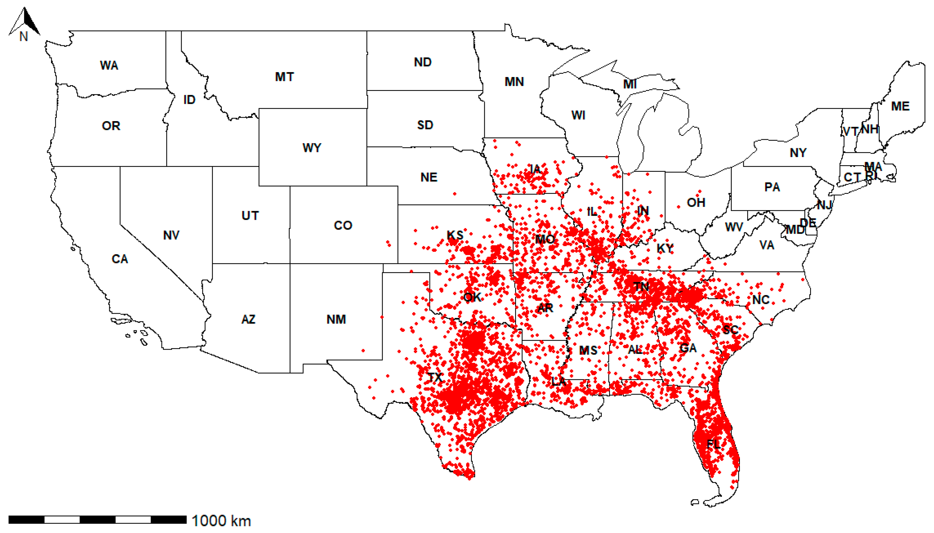
We compiled a comprehensive collection of occurrence records of the species in the U.S. We gathered all publicly available records via the participatory science platform, iNaturalist (accessed on 31 October 2024), and the Biodiversity Information Serving Our Nation (BISON) database of occurrences (https://www.sciencebase.gov/catalog/item/5138e8e5e4b02c509e50c57f accessed on 31 October 2024). We also extracted all armadillo occurrences reported from a nationwide camera trapping study, Snapshot USA [9,10,11,12]. Furthermore, we extracted armadillo occurrence records from peer-reviewed publications (e.g., [4,7]) and white-papers [8]. Finally, we contacted academics and state agency scientists in states along the leading edge of the range expansion to solicit additional occurrence records that have not previously been published or made available online. These records came from a variety of sources, including submissions from the public to state agencies, roadkill records, and reports from hunters or trappers. We included records for which location information could be narrowed down to within 30 km.
We plotted all armadillo occurrences on a map of the U.S. using a Geographic Information System (GIS). We also display state boundaries and major rivers [20].
2.2. Species Distribution Model
In order to understand the associations between armadillo locations and environmental variables at the periphery of their northward expansion, we created a species distribution model. For this approach, we restricted our analysis to only use occurrence records in states at the leading edge of the range expansion (i.e., no confirmed clusters of occurrences occurring in states north of the focal state, or states where armadillos are present but do not yet occur throughout the entirety of the state) including Kansas, Iowa, Illinois, Indiana, Kentucky, Tennessee, and North Carolina. Because armadillos are capable of long-distance individual dispersals [16,21] and are thought to be prone to human transport (intentional or unintentional), we wanted to restrict our analysis to include only occurrences that were likely to represent established areas where armadillos are surviving or at least regularly being documented, so for each state we created 85% kernel density estimates around all armadillo occurrences (Figure 1). Kernel isopleths are probabilistic density estimates to understand the distribution of points across space, and in our application, highlight areas where armadillo occurrences are most likely to occur. We created kernels using the kernelUD function in the package adehabitatHR [22]; by setting the smoothing factor to the default bandwidth (href), we allowed the best smoothing factor to be selected based on our data. We assumed that these kernels would delineate established occurrences and avoid delineating vagrant records within each state.

Figure 1.
All reported occurrences of the nine-banded armadillo (Dasypus novemcinctus) in the United States of America. See Data Availability section for data access.
We parameterized our species distribution model using bioclimatic variables, elevation, human population density, and land use and land cover data. We accessed bioclimatic variables, elevation, and human population raster files using the Geodata package [23] and the National Land Cover Data Layer (NLCD) from https://www.mrlc.gov accessed on 1 October 2024). We initially evaluated 22 bioclimatic variables but first checked these variables for correlation and removed one of the highly correlated variables (>0.8) from each highly correlated pair [24]. We ultimately retained six bioclimatic variables for modeling, including annual mean temperature, mean diurnal temperature range, maximum temperature warmest month, minimum temperature coldest month, precipitation wettest month, and precipitation driest month. In our models, we also used elevation, human population density, and NLCD land cover class. From the NLCD layer, we used the following categories of land cover class: developed (open, low, medium, and high intensity), barren land, forest (deciduous, evergreen, mixed, scrub, and dwarf), grassland, pasture, cultivated crops, and wetlands (woody and emergent herbaceous). Because most variables were measured on separate scales, we Z-transformed all variables for comparison.
Using established protocols [25], we generated a similar number of background points to use as absence points and extracted the same environmental covariates from each background point as armadillo occurrence point. Pseudo-absence points have proven useful in calibrating SDMs [26,27,28]. We extracted the values for the nine remaining environmental variables for presence and background points. We generated the species distribution model using a generalized linear model with a step function to select the best model. We ranked models using Akaike Information Criterion (AIC) values. Since we were using a binary response (presence/absence), we used a binomial distribution with the logit link function [29,30,31]. In addition to linear effects, we also checked for the quadratic effect of each variable (except for NLCD data). Quadratic effects allowed us to explore thresholds and non-linear effects associated with armadillo occurrence and bioclimatic or landscape variables. We also calculated the McFadden’s R-square value and performed cross-validation by splitting the data in 10-fold to check the goodness of fit of our model and predictive power of our model, respectively.
3. Results
We accumulated 2143 armadillo occurrence records with a focus on locations occurring near the leading edge of the geographic distribution (Table 1). After creating 85% kernel density estimates within each state, we determined that armadillos are established in (or frequently and regularly occur in) 17 states; Texas, Louisiana, Mississippi, Alabama, Georgia, Florida, South Carolina, North Carolina, Tennessee, Kentucky, Indiana, Illinois, Missouri, Iowa, Kansas, Oklahoma, and Arkansas (Figure 1). Additionally, there have been occasional reports of armadillos in Nebraska, Michigan, Ohio, and Virginia. We found no evidence of armadillo detections in Minnesota, Wisconsin, or West Virginia. Below, we discuss patterns of spread and distribution within each state located along the edge of armadillo expansion.

Table 1.
Nine-banded armadillo (Dasypus novemcinctus) occurrence records from states at the northern edge of their geographic distribution in the United States. We defined states as being at the leading edge if there were no regular armadillo occurrence records from the state directly north of the focal state or if the entirety of the state did not have regular armadillo occurrence records.
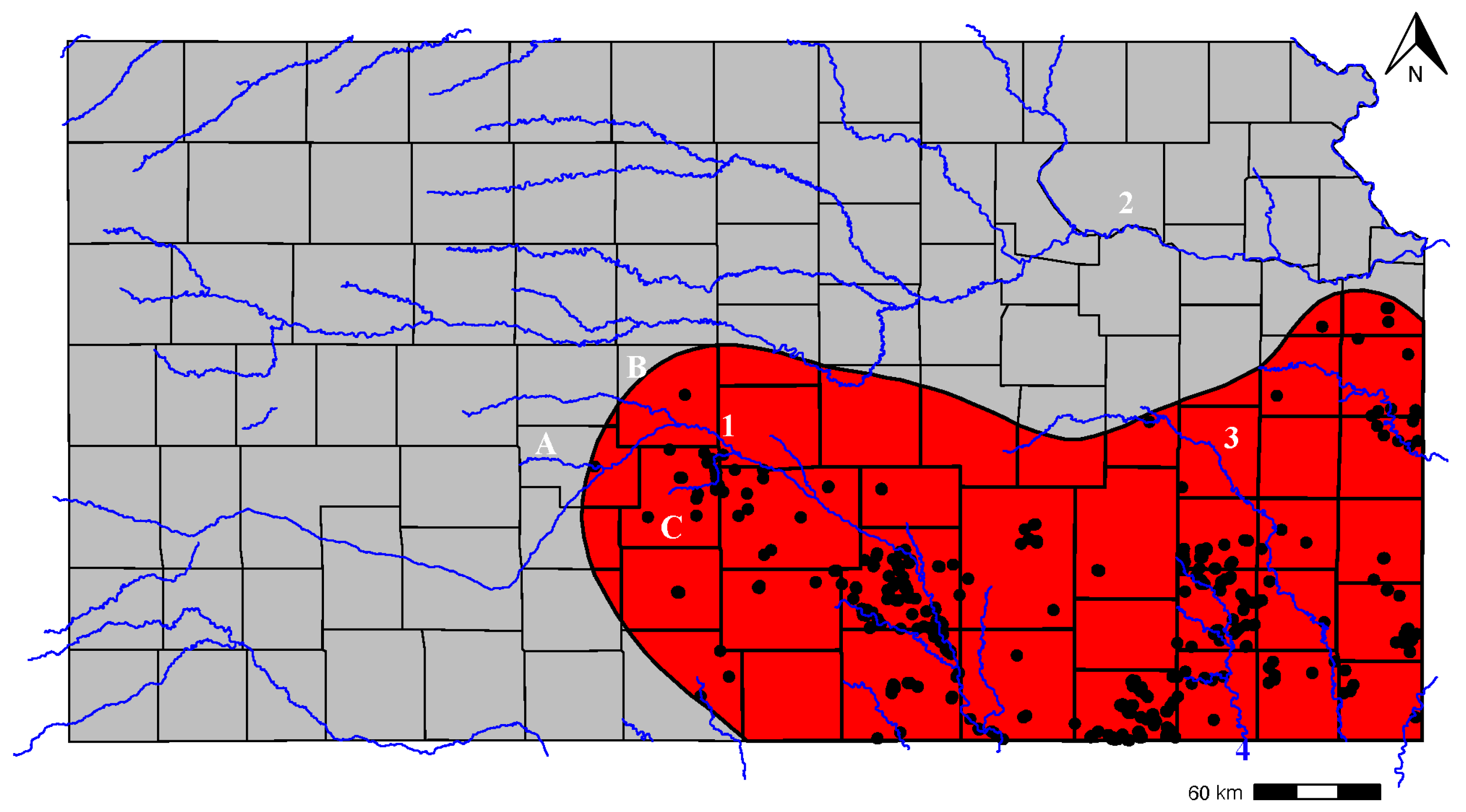
3.1. Kansas
The first reported occurrences of armadillos from Kansas were in the early 1940s [32]. However, sightings continued to be sporadic and rare through the early 1960s [33] and spread into Kansas, which appeared to become rapid in the early 1970s [1]. By the 1990s, the armadillo was firmly established in southcentral and southeastern Kansas [1,4]. Currently, the geographic distribution of armadillos continues to be centered around the southeastern and southcentral portion of the state (Figure 2), although the range limit has moved considerably northwards from that previously delineated [2]. In areas, records of armadillos along the Kansas River are regular. Although there have been a handful of reports of armadillos north of the Kansas River, it does not appear that populations have yet been established north of the river. The greatest concentrations of armadillo occurrences occur along the Arkansas River as far west as Stratford, Barton, and Pawnee Counties, as well as along the Verdigris and Neosho Rivers.
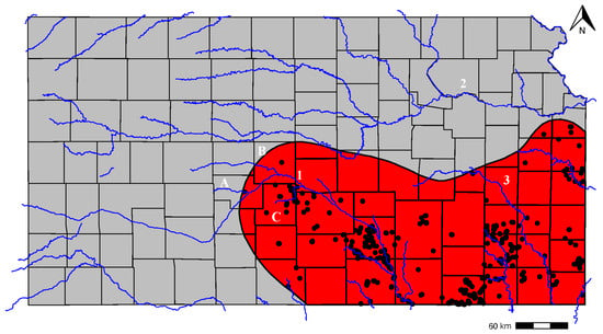
Figure 2.
Geographic distribution of nine-banded armadillos (Dasypus novemcinctus) in the state of Kansas, United States. Shaded areas represent an 85% kernel density isopleth calculated around armadillo occurrence points, square icons denote armadillo occurrence records outside of the kernel isopleth, and blue rivers represent the major river systems. The counties are labeled by letters and rivers by digits. A—Pawnee County, B—Barton County, C—Stafford County. 1—Arkansas River, 2—Kansas River, and 3—Neosho River.
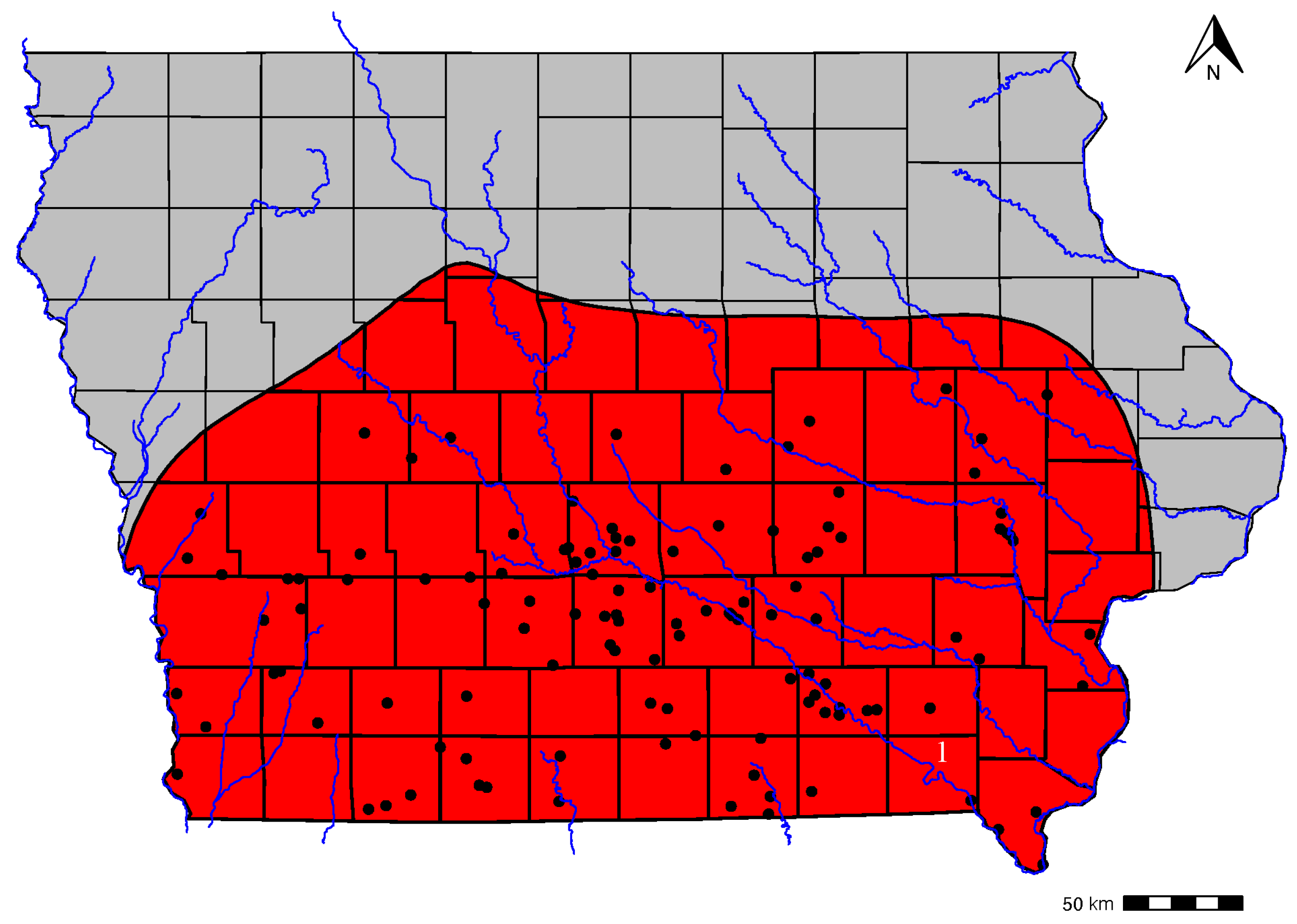
3.2. Iowa
The Iowa Department of Natural Resources has been keeping records of armadillo sightings in Iowa since 2017 and has accumulated 145 records. In fact, the first live armadillo report in the state was in Feb of 2017. Online news reports have highlighted armadillo roadkill sightings as early as 2016 (e.g., https://www.desmoinesregister.com/story/life/2016/08/03/armadillos-in-iowa/87995652/ accessed on 1 October 2024). These armadillos are likely coming north from Missouri, which has established armadillo populations state-wide. Many of the sightings have been along the Des Moines River (Figure 3).

Figure 3.
Geographic distribution of nine-banded armadillos (Dasypus novemcinctus) in the state of Iowa, United States. Shaded areas represent an 85% kernel density isopleth calculated around armadillo occurrence points, square icons denote armadillo occurrence records outside of the kernel isopleth, and blue rivers represent the major river systems. The rivers are labeled by digits. 1—Des Moines River.
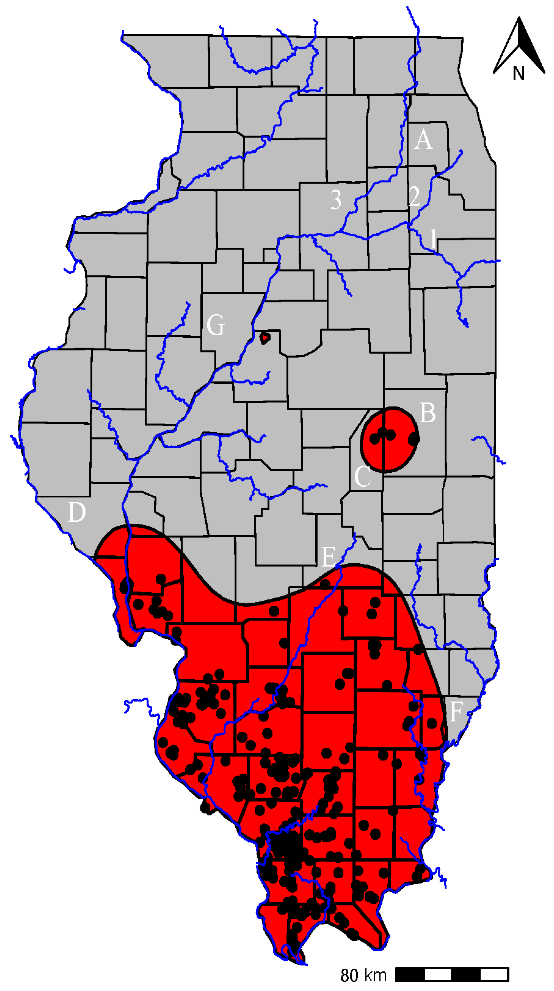
3.3. Illinois
The arrival and spread of armadillos in Illinois has been extensively documented (e.g., [4,6]). The first known record of an armadillo in Illinois was from 1983, Alexander County, in the southwestern portion of the state. We have compiled 411 occurrence records dating back to 1999. The majority of the records are from the southern part of the state (Figure 4). However, the first northernmost record was from DuPage County in 2004, which appears to have been a dispersing individual. It appears that there may be disjunct but established populations in central Illinois, including in Champaign and Piatt Counties. Our Kernel Density estimators indicate established populations as far north as Pike County in the west, Shelby County in central Illinois, and Wabash County in the east. One of the authors (AD) recently documented a live armadillo at a camera trap in Forest Park in Peoria and then later observed a fresh roadkill just outside of the city. Curiously, there have been regular sightings of armadillo in the northwestern portion of Illinois in the Des Plaines, Fox, and Kankakee river areas, although it is unclear if these are sightings of dispersing individuals or indications of an established population. Since the majority of records are closer to the southwestern boundary of Illinois, including the first known record, it appears that they moved into Illinois from Missouri along the Mississippi River drainage.
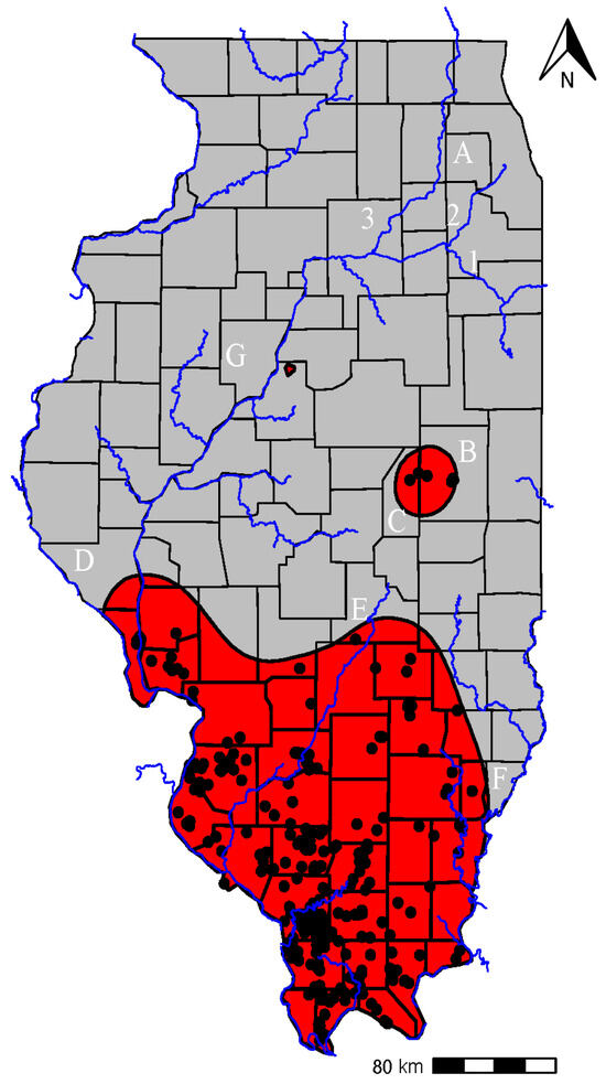
Figure 4.
Geographic distribution of nine-banded armadillos (Dasypus novemcinctus) in the state of Illinois, United States. Shaded areas represent an 85% kernel density isopleth calculated around armadillo occurrence points, square icons denote armadillo occurrence records outside of the kernel isopleth, and blue rivers represent the major river systems. The counties are labeled by letters and rivers by digits. A—DuPage County, B—Champaign County, C—Piatt County, D—Pike County, E—Shelby County, F—Wabash County, G—Peoria County, 1—Kankakee River, 2—Des Plaines River, and 3—Fox River.
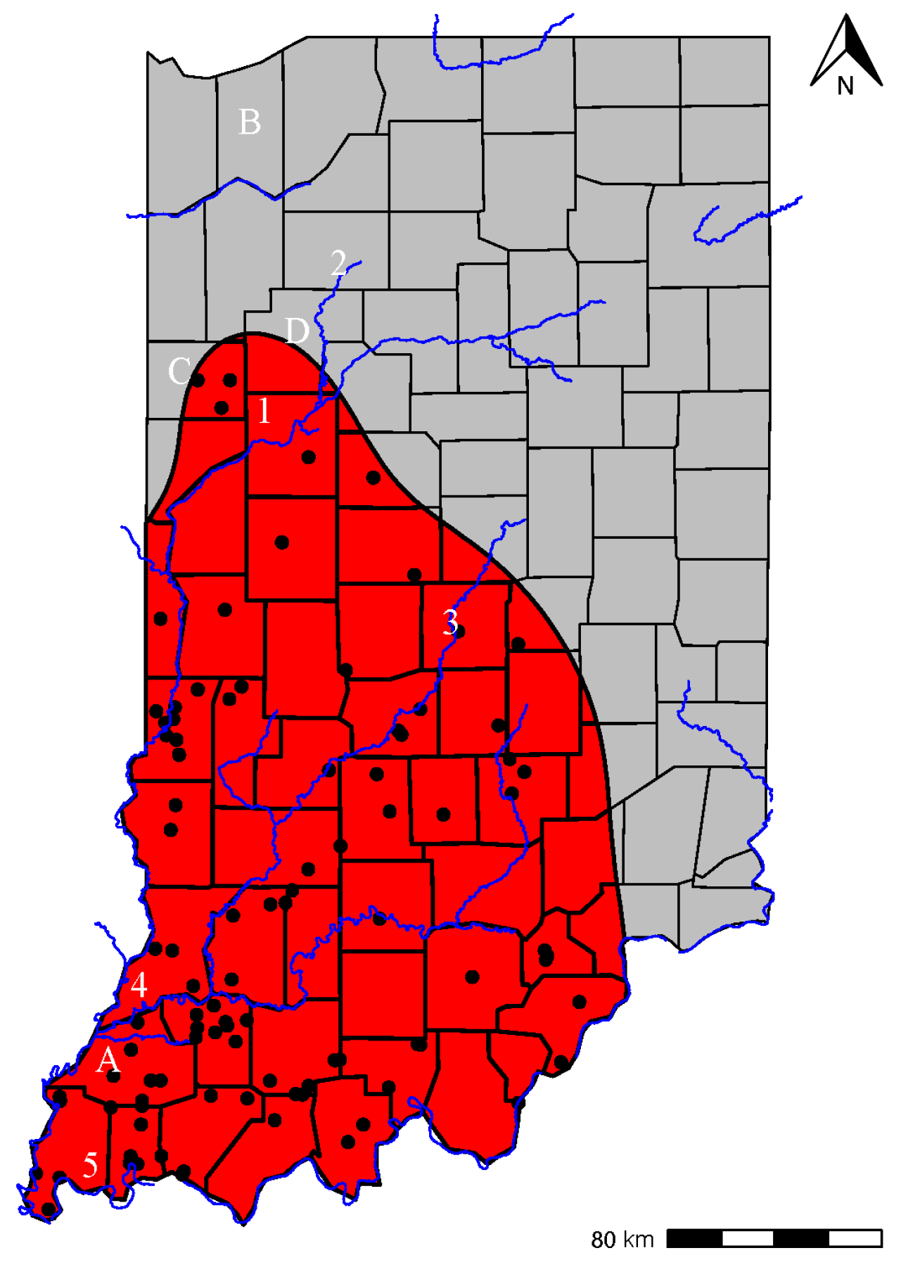
3.4. Indiana
The first confirmed armadillo record in Indiana was in 2003 in the southwestern corner of the state (Gibson County). Over the next 10 years (2003–2013), we are aware of 11 total armadillo detections in Indiana in the southwestern portion of the state across nine different counties in the south and western 1/3 of the state (Figure 5). Because all armadillo records were relatively close to the border with Illinois (max 12 km), it appears likely that movement into Indiana originated from southeastern Illinois rather than from Kentucky. The border with Kentucky consists of the Ohio River, which, due to its large size, is likely an impassable barrier to the species with few, if any, bridges that are suitable for crossing.

Figure 5.
Geographic distribution of nine-banded armadillos (Dasypus novemcinctus) in the state of Indiana, United States. Shaded areas represent an 85% kernel density isopleth calculated around armadillo occurrence points, square icons denote armadillo occurrence records outside of the kernel isopleth, and blue rivers represent the major river systems. The counties are labeled by letters and rivers by digits. A—Gibson County, B—Porter County, C—Benton County, D—White County, 1—Wabash River, 2—Tippecanoe River, 3—Flatrock River, 4—Whitewater River, and 5—Ohio River.
We have compiled 97 armadillo occurrences in Indiana dating back to 2013. The northernmost point was in Porter County, only 8.5 km from the border with Michigan. While this was almost certainly a dispersing individual, armadillo occurrences are at densities, indicating establishment as far north as Benton and White Counties along the Wabash and Tippecanoe Rivers. We have found relatively little evidence that armadillo occurrences are regular east of the Flatrock River. Evidence suggests that armadillos are likely 90 km away from reaching Ohio. Armadillos appear most likely to first reach the southwest corner of Ohio along either the Whitewater River or Ohio River.
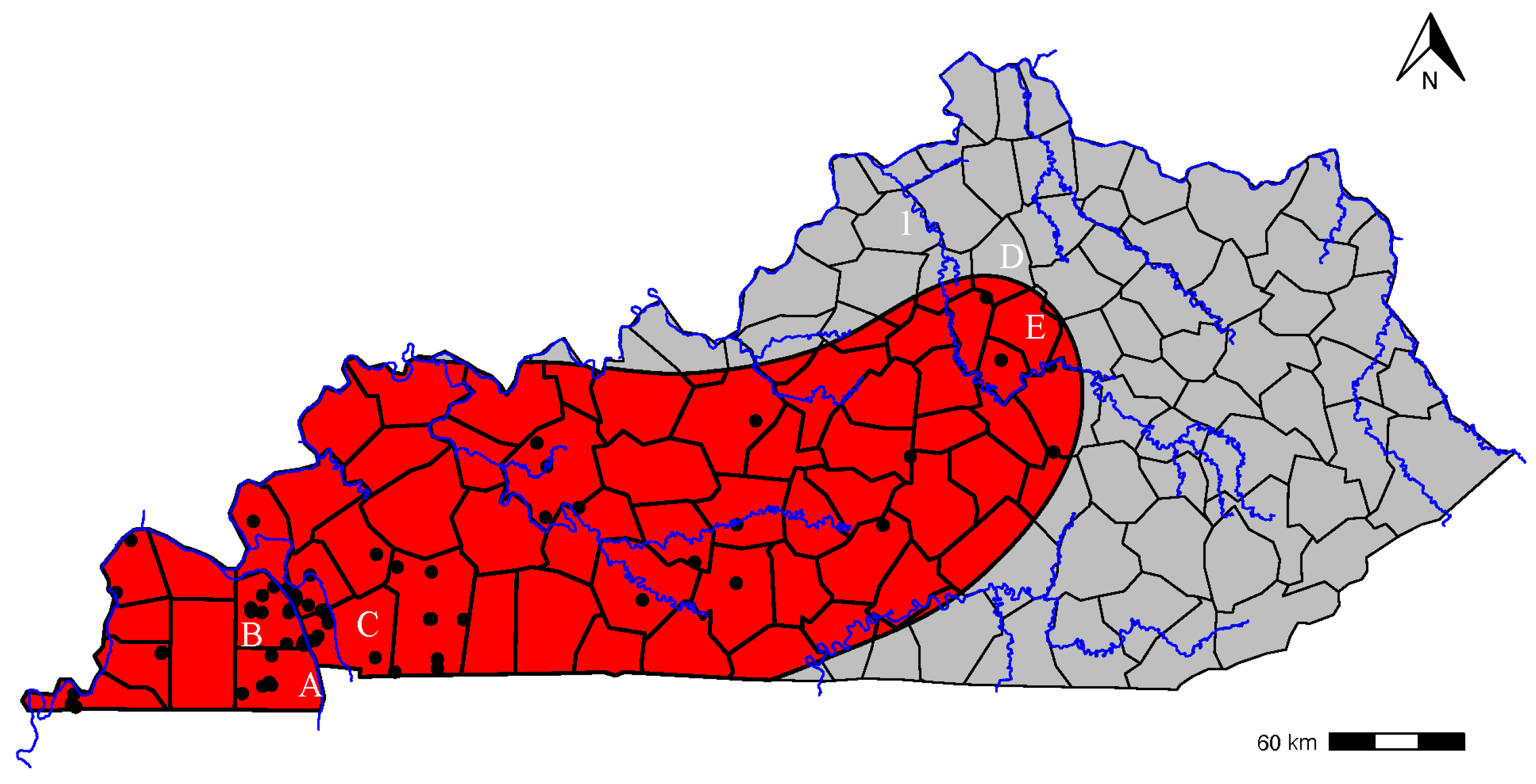
3.5. Kentucky
In the 1996 exploration of armadillo range expansion, it was noted that only four records of armadillos had been reported from the state [1], all along the Mississippi River. By 2014, it was noted that they were firmly established across western Kentucky [2]. Currently, most occurrences are still in the western portion of the state, particularly Calloway, Marshall, and Trigg Counties, although our mapping indicates they may be established as far east as the Kentucky River in Scott and Fayette Counties (Figure 6).

Figure 6.
Geographic distribution of nine-banded armadillos (Dasypus novemcinctus) in the state of Kentucky, United States. Shaded areas represent an 85% kernel density isopleth calculated around armadillo occurrence points, square icons denote armadillo occurrence records outside of the kernel isopleth, and blue rivers represent the major river systems. The counties are labeled by letters and rivers by digits. A—Calloway County, B—Marshall County, C—Trigg County, D—Scott County, E—Fayette County, and 1—Kentucky River.
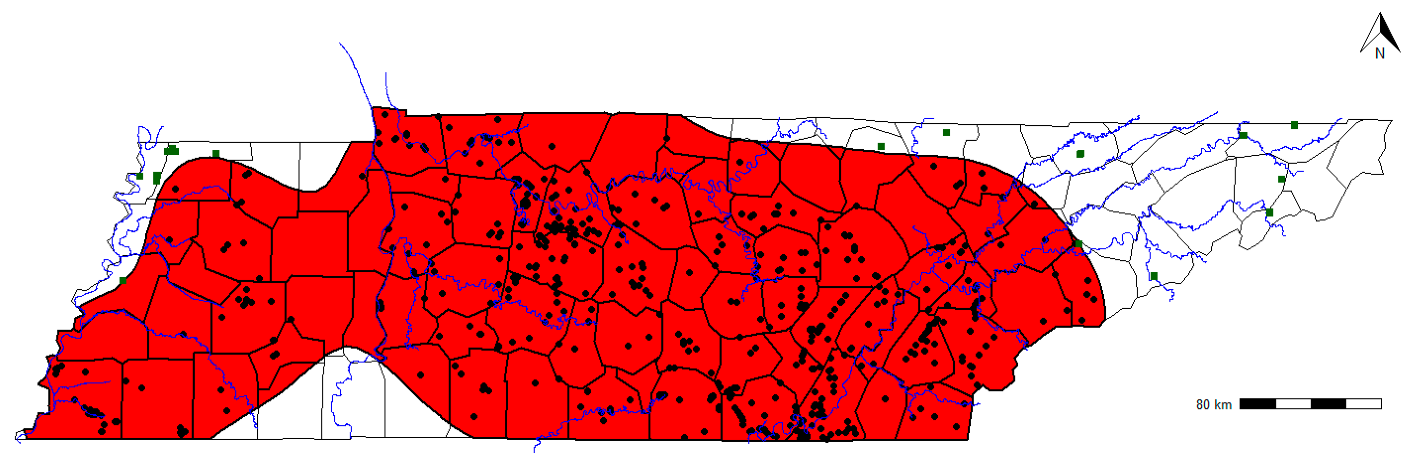
3.6. Tennessee
Armadillos first colonized the southwest portion of Tennessee in the 1980s. They had been present in neighboring Arkansas and Mississippi for at least a decade prior to this and could have colonized from either state. The range of armadillos went from southwest Tennessee along the Mississippi Alluvial Valley to covering all of Tennessee west of mid-Tennessee from 1994 to 2014 [1,2]. Our data show that the armadillo range has further expanded to cover almost all of Tennessee (Figure 7). Although there have been records across the entirety of the state, occurrences remain relatively rare in the northeastern part of the state adjacent to North Carolina and Virginia. Although elevation and slope may be a challenge for armadillos [25,34,35], there have been armadillo records from elevations greater than 600 m above sea level on the Cumberland Plateau in southeastern Tennessee [5].

Figure 7.
Geographic distribution of nine-banded armadillos (Dasypus novemcinctus) in the state of Tennessee, United States. Shaded areas represent an 85% kernel density isopleth calculated around armadillo occurrence points, square icons denote armadillo occurrence records outside of the kernel isopleth, and blue rivers represent the major river systems.
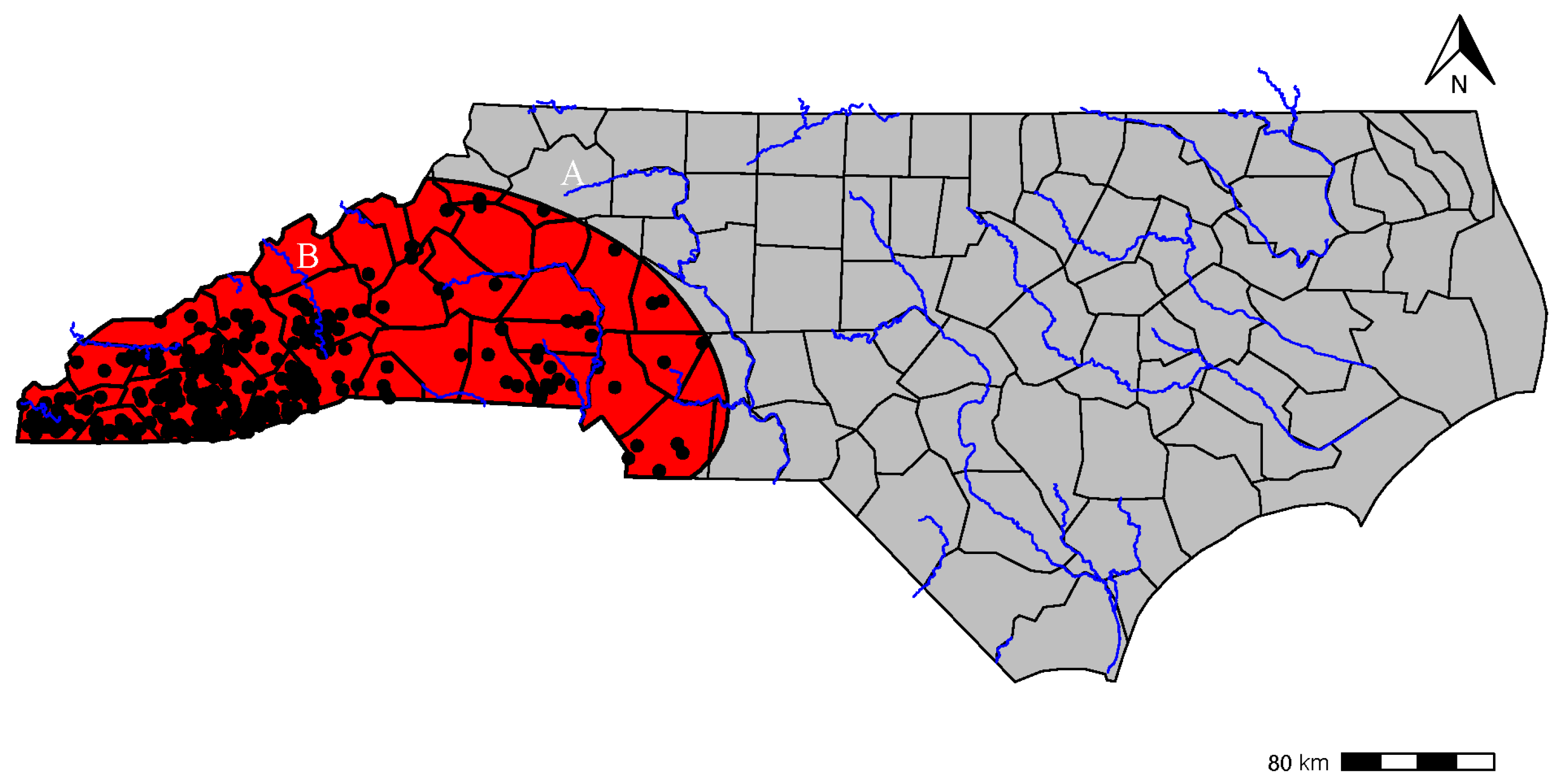
3.7. North Carolina
The range expansion of the armadillo has been carefully observed and documented by the North Carolina Wildlife Resources Commission (NCWRC: [8]). The first credible record in North Carolina was in 2007 in Macon County, located in the far western portion of the state adjacent to Georgia. Since then, the NCWRC has been actively seeking observations from the public to monitor the range expansion and establishment in the state.
Since the first sighting in 2007, the NCWRC has accumulated approximately 900 reports in 70 counties ranging from the westernmost Cherokee County to the easternmost coastal Dare County. As of 2022, the NCWRC has verified sightings in 28 of the reported counties, including, most recently, Wilkes and Madison Counties in the western ¼ of the state (Figure 8). Madison County is notable because it is adjacent to the state of Tennessee. The highest density of sightings were located near the confluence of Georgia, South Carolina, and North Carolina.

Figure 8.
Geographic distribution of nine-banded armadillos (Dasypus novemcinctus) in the state of North Carolina, United States. Shaded areas represent an 85% kernel density isopleth calculated around armadillo occurrence points, square icons denote armadillo occurrence records outside of the kernel isopleth, and blue rivers represent the major river systems. The counties are labeled by letters. A—Wilkes County, and B—Madison County.
3.8. Species Distribution Model
Our generalized linear model (glm) evaluated annual mean temperature, mean diurnal range, precipitation in the wettest month, precipitation in the driest month, minimum temperature of the coldest month, maximum temperature of the coldest month, elevation, human population density, and NLCD land cover class as variables. We ran forward stepwise functions to select the best fit model for generating a species distribution model based on AIC values (see Table 2 for details on all models). In the final, best-supported model with the lowest AIC value (1917.83), all bioclimatic variables (except mean diurnal range), elevation, and human population density were significant in predicting the species distribution pattern for the armadillos (Table 3). Nearly all variables included in the final model had both significant linear and quadratic effects on the distribution pattern of armadillos in their northern range. Mean diurnal range and elevation had only linear effects on armadillo distribution, while human population density and maximum temperature of the warmest month had only quadratic effects. We found no support for land use and land cover variables influencing the distribution of armadillos.
Table 2.
Candidate models to describe the geographic distribution of nine-banded armadillos (Dasypus novemcinctus) in the United States. The model with the lowest Akaike Information Criterion (AIC) value was considered the most competitive model. The term “quad” indicates a quadratic term of the variable.
Table 3.
Variable estimates and significance from the top-ranked model describing nine-banded armadillo (Dasypus novemcinctus) geographic distribution in the United States. Terms shown including both quadratic and linear terms.
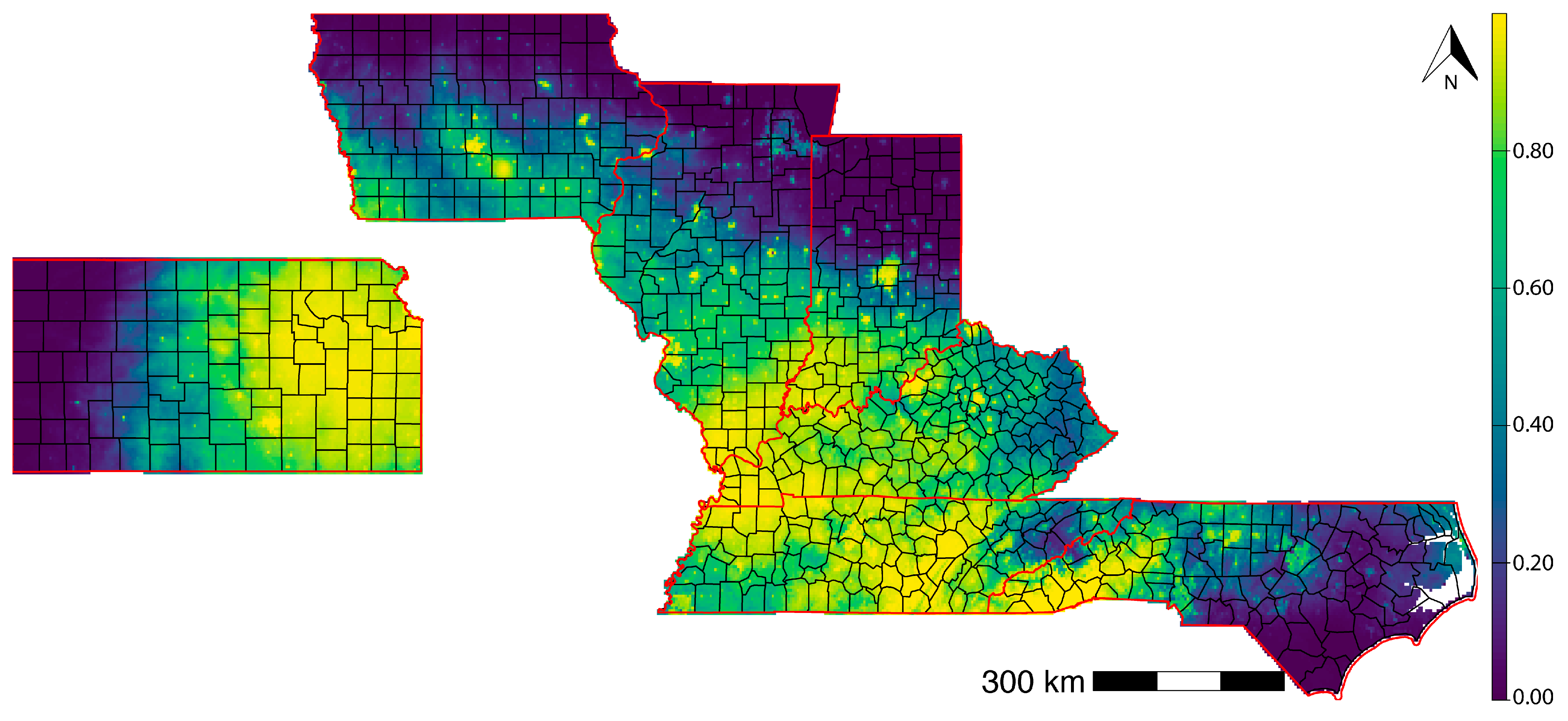
We used the predict function on the glm results to generate a projected species distribution map across the states on the leading edge of armadillo range expansion (Figure 9). The McFadden’s R-square value was 0.73, and the ROC value from the cross-validation was 0.970, suggesting that our model had appropriate goodness of fit and predictive performance.

Figure 9.
Results from a species distribution model of the nine-banded armadillo (Dasypus novemcinctus) potential geographic range within the states on the leading edge of its current range expansion based on bioclimatic variables, human population, and elevation. States shown from left to right are Kansas, Iowa, Illinois, Indiana, Kentucky, Tennessee, and North Carolina.
4. Discussion
The range expansion of the nine-banded armadillo has been of interest to researchers for over 100 years, and several previous efforts have thoroughly explored the contemporary distribution of the species within the United States [1,2,36]. Here, we update previous efforts with the best available distribution data and note numerous areas where range expansion has continued. Compared to the estimated established distribution of armadillos most recently reported [2], our results suggest that armadillos have expanded to cover the entirety of Missouri and colonized southern Iowa, expanded modestly within Kansas and Illinois, expanded northward and eastward in Indiana, substantially expanded eastward in both Kentucky and Tennessee, established throughout the entirety of South Carolina and Georgia, and established in the western third of North Carolina.
At some point, potentially soon, range expansion is likely to be halted by a lack of suitable climate. Because armadillo survival is impacted by cold temperature [37] and likely freezing precipitation, which hinders foraging, there must be a range limit where armadillos can no longer survive and establish [1,2,3,38]. Our species distribution model that was parameterized using only occurrence records within 85% kernel density estimates from the states along the leading edge of the armadillo’s geographic range indicated that armadillo distribution was influenced by six bioclimatic variables (four temperature-based and two precipitation-based), elevation, and human population density. Our model extends the potential geographic range of the armadillo compared to previous modeling efforts. For example, our model indicates that more of Kansas and Iowa may be suitable for armadillos than previously expected [3]. However, in other areas, [3] predicts climate suitability extends far beyond our model’s suggestions. Earlier attempts at developing species distribution models (e.g., [3]) have used the entire range of the nine-banded armadillo in the U.S. While such techniques have their advantages, it can be overly conservative as higher number of occurrence points near tropic and subtropic U.S. forces the model to limit distribution of the armadillo along the leading edge, especially based on climatic constraints. However, by using only the occurrence records from resident populations from states along the leading edge of the range, we were able to counter that constraint. Such a method would lead to better prediction of species distribution, especially of neo-native species (e.g., armadillos) or invasive species. To date, no model has incorporated climate change in armadillo species distribution modeling, a factor that may significantly change how far climate suitability extends across the U.S.
It will be interesting to monitor when armadillos begin to regularly reach and establish in new states such as Michigan, Wisconsin, and Virginia. Mapping the spread of armadillos over time, it appears that Ohio will likely be reached from armadillos spread from west to east in Indiana, Michigan could be reached by armadillos coming north through Indiana or northeast from Illinois, and Virginia has already begun to document armadillos likely coming from North Carolina [7].
The extreme variation in the amount of time that armadillos have been in the “leading edge” states might provide insight into their ability to expand further. Given the length of time that armadillos have been in certain states and the limited spread within those states over the last 10 years, armadillos may be reaching a range limit. For instance, Kansas has had armadillos for at least 50 years, and expansion north has been modest (207 km). Whereas North Carolina has only had armadillos for 17 years, and they appear to be rapidly expanding both north (even into Virginia) and eastward. While they may not yet be established throughout the entire state, there are increasing numbers of sightings across the entirety of the state in each county [8]. While we found little support for land cover influencing the distribution of armadillos, it may certainly influence their ability to or the speed of spread. For instance, Kansas primarily consists of open-canopied land cover, whereas North Carolina is primarily forested. Most occupancy analyses of armadillos have indicated an association with forest cover [6,20,34,39], at least partially due to their foraging behavior, which relies upon leaf litter. Thus, forested regions may experience faster range expansion than areas that are more grassland or agriculturally dominated.
We have made numerous comparisons to the estimated established breeding range as reported in the 1996 and 2014 publications [1,2]. These earlier studies estimated establishment based on surveys of wildlife officers and used negative reports to try and delineate where they believed armadillos were established breeders vs. vagrants. Our methodology was to use a kernel density estimator for each state where a probabilistic distribution was created based on the available occurrence points within each state to attempt to delineate establishment vs. vagrant records. While it is not possible to know which method more accurately delineates the establishment of armadillo populations, we must acknowledge that some of the differences in distribution described here could be due to differences in methodology.
Tracking the geographic range expansion of the armadillos is of interest due to the impacts armadillos can have on the environment around them. As ecosystem engineers, they alter the environment to the benefit of many other wildlife species [14,15]. However, they will also be an important species for wildlife managers to anticipate and be aware of. They can cause damage to infrastructure and property from their digging behavior, and managers may benefit from developing proactive management guidance to share with afflicted landowners. Additionally, because armadillos carry the bacteria responsible for leprosy, there will be public fear of armadillos, and as the species spread, information that is available to the public could allay concerns and combat sensationalist news articles. Our hope is that this updated distributional information will inform local management of armadillos and provide a foundation for future updates or analyses of range-limiting factors.
Author Contributions
Conceptualization, B.A.D. and A.D.; methodology, A.D.; formal analysis, A.D.; resources, B.A.D. and A.D.; data curation, B.A.D. and A.D.; writing—original draft preparation, B.A.D.; writing—review and editing, B.A.D. and A.D.; visualization, A.D. All authors have read and agreed to the published version of the manuscript.
Funding
This research was funded by the Michigan Department of Natural Resources.
Data Availability Statement
Data are available on ScienceBase under IP-174715 [40].
Acknowledgments
We owe thanks to a great many people who provided armadillo occurrence records including James Coffey and the Iowa Dept of Natural Resources, Colleen Olfenbuttal and North Carolina Wildlife Commission, Bradford Westrich and John O Whitaker from Indiana Department of Natural Resources, Michael Fies at Virginia Department of Natural Resources and Nancy Moncrief at the Virginia Museum of Natural History, Shelby Timm and Nathan Bowersock with the Missouri Department of Conservation, Joyce Hoffman with the Illinois Natural History Survey, Erinn Kiesow-Webb, Shawn Rossler, and John White with Wisconsin Department of Natural Resources, Matt Peek and Chris Berens with Kansas Department of Wildlife and Parks, Mack Frantz with West Virginia Department of Natural Resources, Catherine Dennison with Ohio Department of Natural Resources. Any use of trade, firm, or product names is for descriptive purposes only and does not imply endorsement by the U.S. Government.
Conflicts of Interest
The authors declare no conflicts of interest.
References
- Taulman, J.F.; Robbins, L.W. Recent range expansion and distributional limits of the nine-banded armadillo (Dasypus novemcinctus) in the United States. J. Biogeogr. 1996, 23, 635–648. [Google Scholar] [CrossRef]
- Taulman, J.F.; Robbins, L.W. Range expansion and distributional limits of the nine-banded armadillo in the United States: An update of Taulman & Robbins (1996). J. Biogeogr. 2014, 41, 1626–1630. [Google Scholar]
- Feng, X.; Papeş, M. Ecological niche modelling confirms potential north-east range expansion of the nine-banded armadillo (Dasypus novemcinctus) in the USA. J. Biogeogr. 2015, 42, 803–807. [Google Scholar] [CrossRef]
- Hofmann, J.E. Records of Nine-Banded Armadillos, Dasypus novemcinctus, in Illinois. Trans. Ill. State Acad. Sci. 2009, 102, 95–106. [Google Scholar]
- Eichler, S.E.; Gaudin, T.J. New records of the nine-banded armadillo, Dasypus novemcinctus, in southeast Tennessee, and their implications. Edentata 2011, 12, 7–13. [Google Scholar] [CrossRef]
- Haywood, C.J.; Nielsen, C.K.; Jiménez, F.A. Potential distribution of colonizing nine-banded armadillos at their northern range edge. Diversity 2021, 13, 266. [Google Scholar] [CrossRef]
- Moncrief, N.D.; Fies, M.L.; Thompson, S.D. Recent records and range expansion of Dasypus novemcinctus (Nine-banded armadillo) in Virginia. Southeast. Nat. 2021, 20, N73. [Google Scholar] [CrossRef]
- Olfenbuttel, C. Armadillo Range Expansion 2007 Through 2022. In A Report to North Carolina Wildlife Resources Commission; North Carolina Wildlife Resources Commission: Raleigh, NC, USA, 2022; pp. 1–9. [Google Scholar]
- Kays, R.; Cove, M.V.; Diaz, J.; Todd, K.; Bresnan, C.; Snider, M.; Lee, T.E., Jr.; Jasper, J.G.; Douglas, B.; Crupi, A.P.; et al. SNAPSHOT USA 2020: A Second Coordinated National Camera Trap Survey of the United States During the COVID-19 Pandemic; Wiley Online Library: Hoboken, NJ, USA, 2022. [Google Scholar]
- Cove, M.V.; Kays, R.; Bontrager, H.; Bresnan, C.; Lasky, M.; Frerichs, T.; Klann, R.; Lee, T.E., Jr.; Crockett, S.C.; Crupi, A.P.; et al. SNAPSHOT USA 2019: A Coordinated National Camera Trap Survey of the United States; Wiley Online Library: Hoboken, NJ, USA, 2021. [Google Scholar]
- Shamon, H.; Maor, R.; Cove, M.V.; Kays, R.; Adley, J.; Alexander, P.D.; Allen, D.N.; Allen, M.L.; Appel, C.L.; Barr, E.; et al. Evan Barr SNAPSHOT USA 2021: A third coordinated national camera trap survey of the United States. Ecology 2024, 105, e4318. [Google Scholar] [CrossRef] [PubMed]
- Rooney, B.; Kays, R.; Cove, M.V.; Jensen, A.; Goldstein, B.R.; Pate, C.; Castiblanco, P.; Abell, M.E.; Adley, J.; Lesmeister, D.B.; et al. Briana Agenbroad SNAPSHOT USA 2019–2023: The First Five Years of Data from a Coordinated Camera Trap Survey of the United States. Glob. Ecol. Biogeogr. 2025, 34, e13941. [Google Scholar] [CrossRef]
- Platt, S.; Rainwater, T.; Brewer, S. Aspects of the burrowing ecology of nine-banded armadillos in northern Belize. Mamm. Biol. 2004, 69, 217–224. [Google Scholar] [CrossRef]
- DeGregorio, B.A.; Veon, J.T.; Massey, A. Wildlife associates of nine-banded armadillo (Dasypus novemcinctus) burrows in Arkansas. Ecol. Evol. 2022, 12, e8858. [Google Scholar] [CrossRef] [PubMed]
- Lamb, B.D.; Anderson, C.D.; McDonough, C.M.; Lockhart, J.M.; Butler, Z. A Comparison of Vertebrate Associates of Gopher Tortoise and Nine-Banded Armadillo Burrows in South Georgia. Chelonian Conserv. Biol. 2023, 22, 184–196. [Google Scholar] [CrossRef]
- Gammons, D.J.; Mengak, M.T.; Conner, L.M. Translocation of nine-banded armadillos. Hum. Wildl. Confl. 2009, 3, 64–71. [Google Scholar]
- McDonough, C.M.; Loughry, W. Impacts of land management practices on a population of nine-banded armadillos in northern Florida. Wildl. Soc. Bull. 2005, 33, 1198–1209. [Google Scholar] [CrossRef]
- Rodrigues, T.F.; Mantellatto, A.M.; Superina, M.; Chiarello, A.G. Ecosystem services provided by armadillos. Biol. Rev. 2020, 95, 1–21. [Google Scholar] [CrossRef]
- DeGregorio, B.A.; McElroy, M.R.; Johansson, E. Occupancy and Activity Patterns of Nine-Banded Armadillos (Dasypus novemcinctus) in a Suburban Environment. Diversity 2023, 15, 907. [Google Scholar] [CrossRef]
- National Weather Service. 2024. Available online: https://www.weather.gov/gis/USStates (accessed on 1 October 2024).
- Loughry, J.; McDonough, C. The Nine-Banded Armadillo: A Natural History, 1st ed.; University of Oklahoma Press: Norman, OK, USA, 2013; pp. 1–323. [Google Scholar]
- Calenge, C. The package “adehabitat” for the R software: A tool for the analysis of space and habitat use by animals. Ecol. Model. 2006, 197, 516–519. [Google Scholar] [CrossRef]
- Hijmans, R.J.; Barbosa, M.; Ghosh, A.; Mandel, A. Geodata: Download Geographic Data. R Package Version 0.5-8; R Core Team: Cary, CA, USA, 2023. [Google Scholar]
- Deshwal, A.; Panwar, P.; Neal, J.C.; Young, M.A. Using long-term citizen science data to understand distribution and habitat use of an irruptive species. Ecol. Inform. 2021, 64, 101377. [Google Scholar] [CrossRef]
- Barbet-Massin, M.; Jiguet, F.; Albert, C.H.; Thuiller, W. Selecting pseudo-absences for species distribution models: How, where and how many? Methods Ecol. Evol. 2012, 3, 327–338. [Google Scholar] [CrossRef]
- Chefaoui, R.M.; Lobo, J.M. Assessing the effects of pseudo-absences on predictive distribution model performance. Ecol. Model. 2008, 210, 478–486. [Google Scholar] [CrossRef]
- Wisz, M.S.; Guisan, A. Do pseudo-absence selection strategies influence species distribution models and their predictions? An information-theoretic approach based on simulated data. BMC Ecol. 2009, 9, 8. [Google Scholar] [CrossRef]
- Václavík, T.; Meentemeyer, R.K. Invasive species distribution modeling (iSDM): Are absence data and dispersal constraints needed to predict actual distributions? Ecol. Model. 2009, 220, 3248–3258. [Google Scholar] [CrossRef]
- Donázar, J.A.; Hiraldo, F.; Bustamante, J. Factors influencing nest site selection, breeding density and breeding success in the bearded vulture (Gypaetus barbatus). J. Appl. Ecol. 1993, 504–514. [Google Scholar] [CrossRef]
- Bustamante, J. Predictive models for lesser kestrel Falco naumanni distribution, abundance and extinction in southern Spain. Biol. Conserv. 1997, 80, 153–160. [Google Scholar] [CrossRef]
- Martínez, J.A.; Serrano, D.; Zuberogoitia, I. Predictive models of habitat preferences for the Eurasian eagle owl Bubo bubo: A multiscale approach. Ecography 2003, 26, 21–28. [Google Scholar] [CrossRef]
- Hibbard, C.W. A checklist of Kansas mammals. Trans. Kans. Acad. Sci. 1943, 47, 61–88. [Google Scholar] [CrossRef]
- Smith, J.D.; Lawlor, T.E. Additional records of the armadillo in Kansas. Southwest. Nat. 1964, 9, 48–49. [Google Scholar] [CrossRef]
- Turner, C.M. Assessing Prevalence of Hansen’s Disease in Tennessee with Assistance from Community Science Data. Master’s Thesis, University of Tennessee at Chattanooga, Chattanooga, TN, USA, 2023. [Google Scholar]
- McTigue, L.E.; DeGregorio, B.A. Nine-banded armadillo (Dasypus novemcinctus) occupancy and density across an urban to rural gradient. Southeast. Nat. 2024, 23, 529–548. [Google Scholar] [CrossRef]
- Humphrey, S.R. Zoogeography of the nine-banded armadillo (Dasypus novemcinctus) in the United States. BioScience 1974, 24, 457–462. [Google Scholar] [CrossRef]
- McNab, B.K. Energetics and the limits to a temperate distribution in armadillos. J. Mammal. 1980, 61, 606–627. [Google Scholar] [CrossRef]
- McDonough, C.M.; Delaney, M.A.; Le, P.Q.; Blackmore, M.S.; Loughry, W.J. Burrow characteristics and habitat associations of armadillos in Brazil and the United States of America. Rev. Biol. Trop. 2000, 48, 109–120. [Google Scholar]
- Rodrigues, T.F.; Chiarello, A.G. Native forests within and outside protected areas are key for nine-banded armadillo (Dasypus novemcinctus) occupancy in agricultural landscapes. Agric. Ecosyst. Environ. 2018, 266, 133–141. [Google Scholar] [CrossRef]
- Deshwal, A.D.; DeGregorio, B.A. Current Geographic Distribution of Armadillos in the United States; United States Geological Survey: Reston, VA, USA, 2025. [Google Scholar] [CrossRef]
Disclaimer/Publisher’s Note: The statements, opinions and data contained in all publications are solely those of the individual author(s) and contributor(s) and not of MDPI and/or the editor(s). MDPI and/or the editor(s) disclaim responsibility for any injury to people or property resulting from any ideas, methods, instructions or products referred to in the content. |
© 2025 by the authors. Licensee MDPI, Basel, Switzerland. This article is an open access article distributed under the terms and conditions of the Creative Commons Attribution (CC BY) license (https://creativecommons.org/licenses/by/4.0/).