Article

Investigation and Evaluation of Geothermal Resources in Northern Shanxi Province, China

1
College of Earth Sciences, Guilin University of Technology, Guilin 541004, China
2
Department of Geology and Surveying Engineering, Shanxi Institute of Energy, Jinzhong 030600, China
3
Geophysical Survey Institute of Guangxi Zhuang Autonomous Region, Liuzhou 541006, China
4
Guangxi Shuangke Construction Engineering Consulting Co., Ltd., Nanning 530009, China
*
Authors to whom correspondence should be addressed.
Energies 2025, 18(6), 1494; https://doi.org/10.3390/en18061494
Submission received: 31 January 2025 / Revised: 4 March 2025 / Accepted: 15 March 2025 / Published: 18 March 2025

Abstract

:
In this study, survey methods including seismic techniques and controlled-source audio-frequency magnetotelluric, drilling, and pumping tests were employed to investigate the geothermal systems and their formation mechanisms in northern Shanxi Province, China. The following characteristics were observed: (1) Geothermal resources in northern Shanxi Province are primarily located in Archean metamorphic rocks and fracture zone aquifer groups. The direct heat source is likely uncooled magma chambers in the middle-upper crust, whereas the overlying layers consist of Quaternary, Neogene, and Paleogene deposits. (2) The high-temperature geothermal system is of the convective-conductive type: atmospheric precipitation and surface water infiltrate pore spaces and fault fractures to reach thermal storage, where they are heated. Hot water then rises along the fracture channels and emerges as shallow hot springs, and ongoing extensional tectonic activity has caused asthenospheric upwelling. The partial melting of the upper mantle forms basic basaltic magma, which ascends to the middle-upper crust and forms multiple magma chambers. Their heat is transferred to the shallow subsurface, causing geothermal anomalies. (3) Borehole YG-1 findings revealed that these geothermal resources are primarily static reserves. Our findings provide a foundation for further geothermal development in the region, including the strategic deployment of wells to improve geothermal energy extraction.

1. Introduction

Geothermal resources are novel green energy sources resulting from heat, water, and minerals beneath the Earth’s surface. They are highly competitive owing to their vast reserves, wide distribution, stability, and recyclability [1,2,3]. Unlike other weather-dependent renewable energies such as tides, wind, and solar power, geothermal energy is virtually inexhaustible and unaffected by weather conditions. The development and utilization of geothermal resources can yield considerable economic and environmental benefits, including geothermal power generation, residential heating, aquaculture, healthcare, and hot spring bathing. Consequently, many countries have increasingly dedicated resources to geothermal energy research and development [4,5].
Geothermal resources are abundant in the Shanxi Province, with relatively concentrated spatial distributions in six major areas: Taiyuan-Jincheng, Datong-Shuozhou, Xinzhou, Changzhou–Jincheng, Lvliang-Linfen, and Linfen-Yuncheng. The total reserves of shallow geothermal fluids (to a 3000 m depth) in Shanxi Province amount to 2.970 × 10¹² m3, with a total thermal energy of 1.769 × 10¹⁸ kJ, equivalent to 60.3588 billion tons of standard coal. The exploitable thermal energy totals 2.740 × 10¹⁸ kJ, or 9.35 billion tons of standard coal [6]. It is worth noting that the geothermal resources in China are mainly distributed in southern Tibet, western Sichuan, western Xinjiang, western Yunnan, and Taiwan. Compared to other provinces, Shanxi Province does not have a noticeable advantage in terms of geothermal resource reserves. Therefore, conducting geothermal resource surveys in the Shanxi Province has significant implications for promoting local economic development.
Geothermal exploration in northern Shanxi began during the 1990s. Recently, Zhang et al. [7] evaluated and compared the exploitable quantities of geothermal fluids across an entire region using methods such as thermal storage analysis, analytical methods, statistical analysis, and numerical simulation. Liu et al. [2] calculated the potential development and utilization of the geothermal resources in northern Shanxi using geothermal fluid thermal potential modulus indicators. Dai et al. [8] estimated the exploitable quantity of geothermal fluids to a depth of 3500 m in northern Shanxi using parameters such as the geothermal resource recovery rate, well layout scale, single-well production, national hydrothermal decline permit index, extraction–reinjection well distance, reinjection volume, and extraction time. Their results indicated that the extractable geothermal water volume was 163.79 × 10¹⁸ m3, accounting for 50% of the total stored water volume, containing thermal energy of 37.76 × 10⁹ GJ, equivalent to 2.579 × 10⁸ tons of standard coal. Based on the studies of 26 geothermal exploration wells including water quality analysis and trial mining tests, Zhu et al. [9] evaluated the geothermal resources of the Xiong’an New Area using exploitation coefficient and extraction–injection equilibrium methods. The calculable exploitable resource volume and thermal energy were significantly greater with the extraction–injection equilibrium method, which better approximated the actual development scenarios. Under extraction–injection equilibrium conditions, the total exploitable geothermal fluid resource volume across the region was 401.77 × 10⁶ m3/year, with an exploitable thermal energy of 1013.2 × 1014 J/year, equivalent to 346.99 × 10⁴ tons/year of standard coal. Moreover, scholars have conducted geothermal resource potential evaluations based on fuzzy mathematics [10] and three-dimensional geological modeling [11], integrating various attributes distributed across different regions to estimate the geothermal resource characteristics.
However, previous research has rarely addressed the reasons underlying the formation and transfer mechanisms of geothermal systems in northern Shanxi Province. Therefore, focusing on key issues such as water sources, heat sources, thermal storage, cap rocks, and conduction mechanisms and building upon earlier work, a 20 km2 area was selected as the research area. In this study, the regional geological background was investigated, integrating relevant geological surveys, geophysical exploration (seismic methods and CSAMT), and drilling results, to model and explore the formation mechanism of the geothermal system in this region. Moreover, suggestions for resource development and utilization are proposed. These findings provide a reference for advancing the geothermal development in this region and neighboring provinces.

2. Geological Background

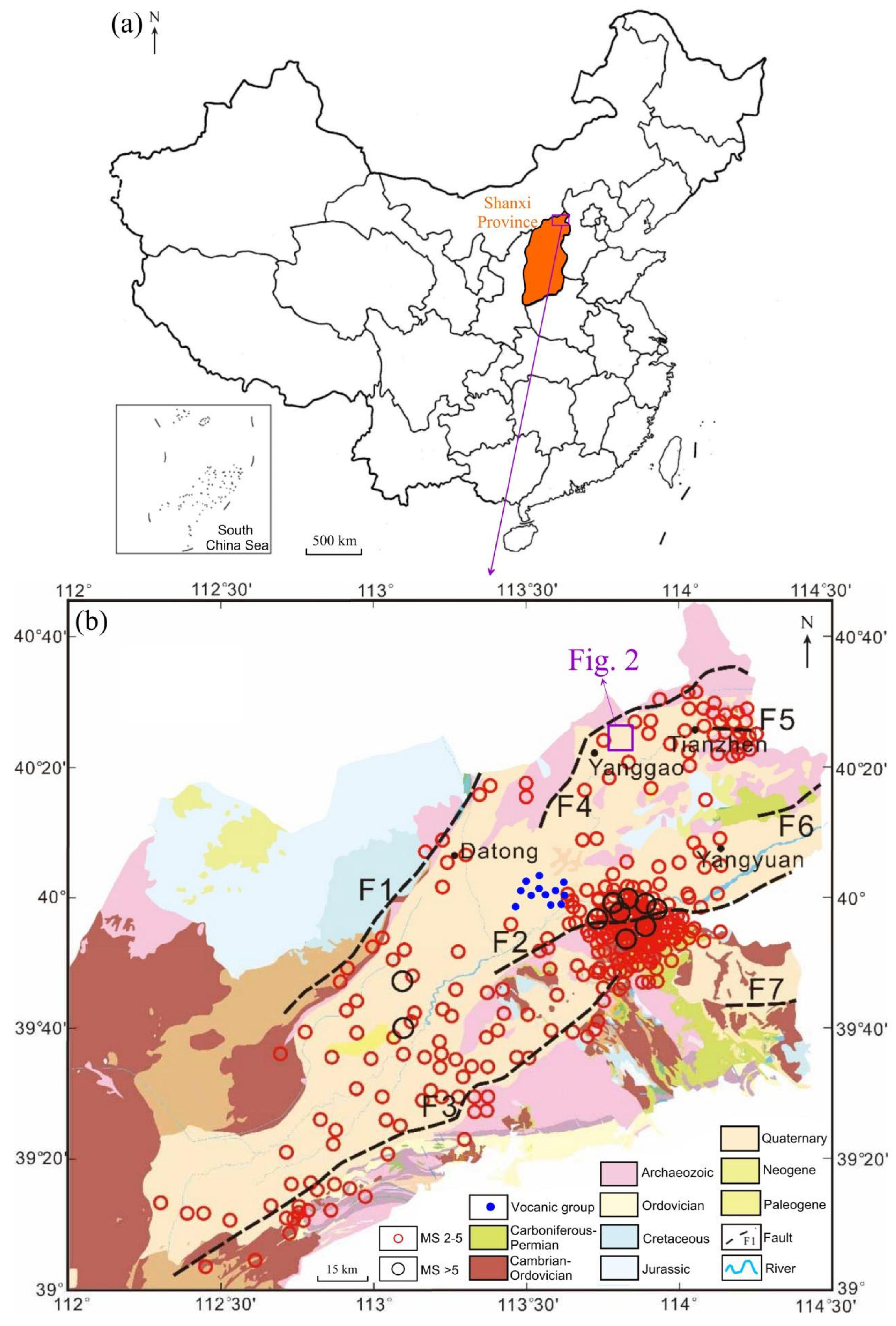
2.1. Geological Setting

The study area is located 4 km north of Yanggao County, Shanxi Province, within a secondary basin in the northeastern Datong Basin. The overall orientation of this basin extends northeast (NEE) and falls within the northern margin of the active belt of the North China Plate [12]. The Datong Basin is a Cenozoic fault-graben basin situated in the central part of the North China Craton, at the intersection of the Central Belt of the North China Block and the Inner Mongolia Suture Zone. Since the Late Mesozoic, it has undergone multiple phases of tectonic movements [13,14].
During the Cenozoic, the basin was primarily characterized by inherited fault activity. Under an extensional tectonic environment, the bounding faults controlling the basin progressively slipped toward the basin center, evolving into a series of step-like normal faults. Combined with the main boundary faults, these faults controlled the formation of a NE-SW-trending half-graben structure.
Within the basin, faults dominate the structural features, whereas folds are less significant. The predominant structural direction is NE. The key faults are illustrated in Figure 1. The Kouquan Mountain Fault (F1) trends NNE, whereas the Liuleng Mountain Fault (F2), Hengshan Fault (F3), Miheng Fault (F4), Xiongere Mountain North Fault (F5), Xiongere Mountain South Fault (F6), and Xiaowutai Mountain Fault (F7) exhibit NEE trends. Several concealed faults are present in this region.
The geological survey results revealed that the stratigraphy within the study area primarily comprises Archean epidermal rocks and Neogene and Quaternary deposits. The Archean epidermal rocks exhibit complex lithology, predominantly consisting of metamorphic rocks such as magnetite quartzite, diopside hornblende gneiss, and plagioclase amphibolite, with the widespread development of intrusive rocks ranging from the Neoarchean to the Cenozoic. The Neogene and Quaternary strata are distributed in the southern basin and are characterized by sand-gravel interbedded with sandy soil and loose alluvial deposits, varying in thickness from 0 to 300 m and gradually thickening toward the basin center.

2.2. Geothermal Geological Conditions

The Datong Basin evolved from the Shanxi Plateau and is located within a continental lithospheric extensional rift zone. Since the Quaternary, a series of volcanic eruptions and magma outpourings have occurred in the basin, influenced by neotectonic movements. Volcanic activity began in the late Early Pleistocene at approximately 0.78 Ma and ended in the early Late Pleistocene at approximately 0.1 Ma, exhibiting three phases of volcanic activity. The lithosphere thinned under the effect of extensional tensile stress, leading to an upsurge in asthenospheric material and partial melting of the upper mantle material. The magma ascended along major deep faults and weak tectonic zones, erupted or overflowed onto the surface, and formed the Datong Volcanic Group [16].
Volcanoes are distributed around the basin and in the southern part and are concentrated near major deep faults. In contrast, there is less volcanic rock exposure in the northeastern part of the basin around Yanggao and Tianzhen, suggesting that this area is a magma intrusion zone with deep-seated magma or high-temperature anomalies, potentially forming an excellent thermal source accumulation zone.
In addition, small earthquakes frequently occur in the Datong Basin, particularly in the vicinity of boundary faults. These events were primarily shallow earthquakes with depths of approximately 10 km [17]. Earthquakes above magnitude 5 are concentrated near the middle section of Fault F2, whereas those below magnitude 5 mainly occur in the Yanggao-Tianzhen seismic zone and near Faults F2 and F5, as shown in Figure 1. Seismic activity occurs in areas with active tectonics, intense volcanic activity, and intraplate ruptures, where the geological structural activities are strong and terrestrial heat flow values are high, making these locations optimal for geothermal anomalies. Earthquakes are typically associated with geothermal resources. According to Jingping et al. [18], areas with dense earthquake distributions typically exhibit higher geothermal gradients. Therefore, earthquake activity can be a significant indicator of potential geothermal resources.
The terrestrial heat flow value (75.3–79.5 mW/m2) of the study area significantly exceeds that of the surrounding mountainous areas (37.7–46.1 mW/m2) and is higher than the average surface heat flow value (50–65 mW/m2) [19]. This indicates that the study area exhibits favorable geothermal conditions.

3. Methodology

3.1. Introduction of Methods

Seismic methods can be employed to determine underground structures and geological features by observing and analyzing the characteristics of seismic wave propagation underground. In this approach, seismic instruments are used to record the propagation process of seismic waves, and following data processing and interpretation, information about underground rock layers and faults can be inferred. Seismic exploration has advantages such as high resolution, non-invasiveness, and speed, making it widely applicable in the study of underground structures and geological hazards.
The principle of seismic methods lies in utilizing changes in the propagation velocity and paths of seismic waves in different geological media to infer the underground structures and geological features. Initially, seismic instruments were deployed on the ground or at the tops of boreholes to record the propagation of seismic waves. Subsequently, through data processing and interpretation, parameters such as the velocity, amplitude, and spectrum of seismic waves were analyzed to obtain geological information regarding the underground rock layers, faults, and pore water.
CSAMT is a frequency-domain artificial source electromagnetic technology based on the magnetotelluric method (MT) that exhibits the following advantages.
(1)
Large exploration depth: In the CSAMT, parameters such as the transmission frequency range and transmission and reception distances can be set according to the geoelectric characteristics of each work area. Compared to the loop-source TEM, when a lower emission frequency is used, the exploration depth increases, reaching up to 2 km or more.
(2)
Significant penetration of the high-resistivity shielding layer: This method receives perpendicular electric and magnetic fields simultaneously. The electromagnetic signal is perpendicular to the ground in the receiving area, and the observation and calculation of the electromagnetic component are normalized. Therefore, it can effectively penetrate high-resistivity cap layers on the ground.
(3)
Larger transmitting power and strong anti-interference ability: This method adopts an artificially controllable transmitting source with a high transmitting power (up to 30 kW) capable of precise frequency division, excellent stability, and high-order superposition. It can also suppress the interference of ground electricity.
(4)
Effective exploration of high-resistivity basement formations: In cases with a significant exploration depth, generally in high-resistivity basement formations, CSAMT uses a lower operating frequency (less than 1 Hz) as the transmitting signal, which exhibits reduced signal attenuation in this frequency band.
Therefore, seismic and CSAMT methods were used to investigate the geological structure and characteristics of the heat sources, thermal reservoirs, and cap layers within the study area.
GEOVECTEURPLUS (developed by CGG) was used to process the seismic data, and CSAMT3DV software V7.1.05 (developed by the Institute of Geology and Geophysics at the Chinese Academy of Sciences) was used to process the CSAMT data.
A drilling operation was also conducted to verify the investigation results.

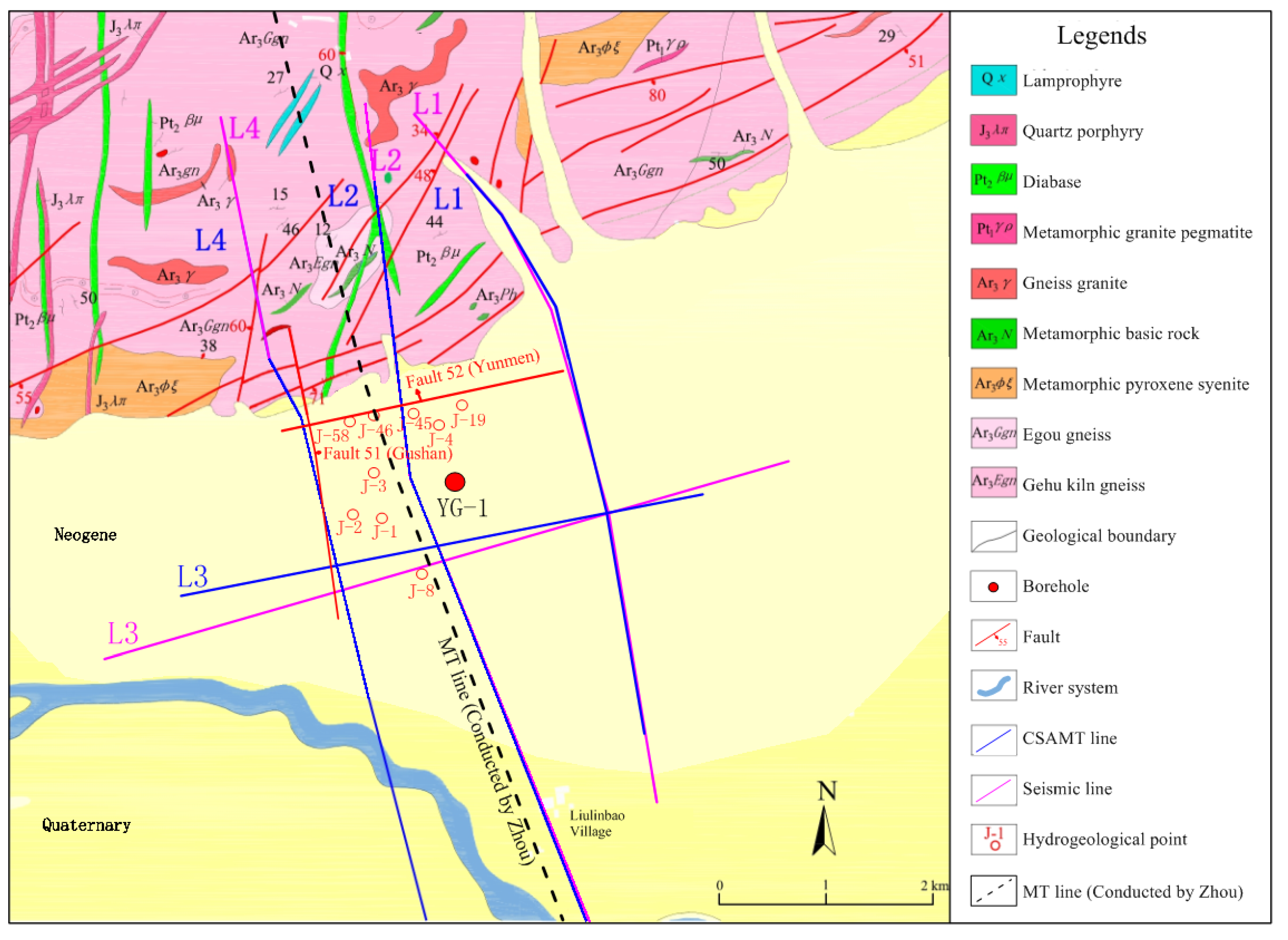
3.2. Survey Line Layout

The locations of the seismic lines, CSAMT lines, and YG-1 exploration wells are illustrated in Figure 2. Upon the completion of drilling, pumping tests and static temperature measurements were performed to obtain parameters such as geothermal gradients and specific discharge rates. These data were used to calculate the terrestrial heat flow values in the study area.

4. Results

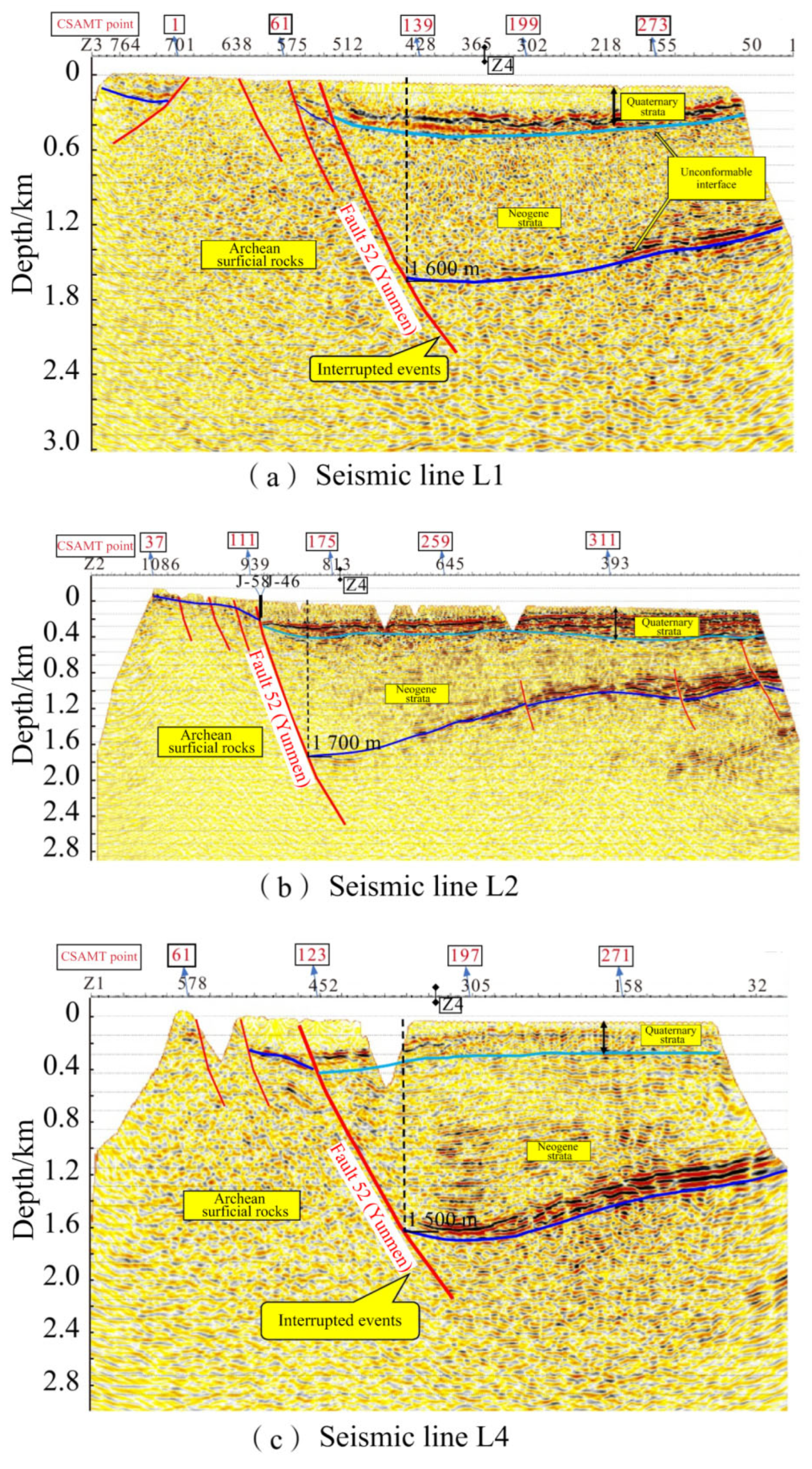
4.1. Seismic Exploration
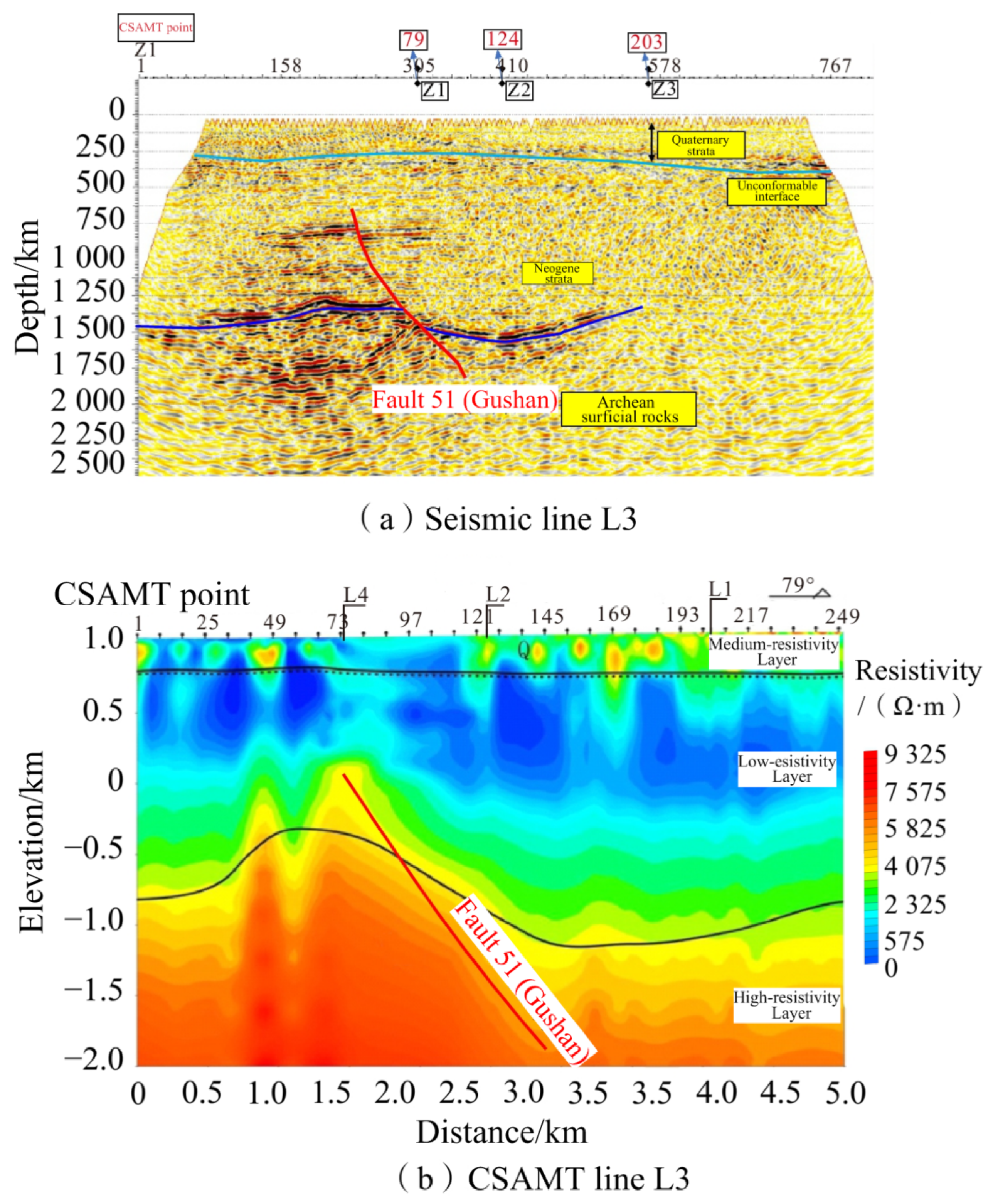
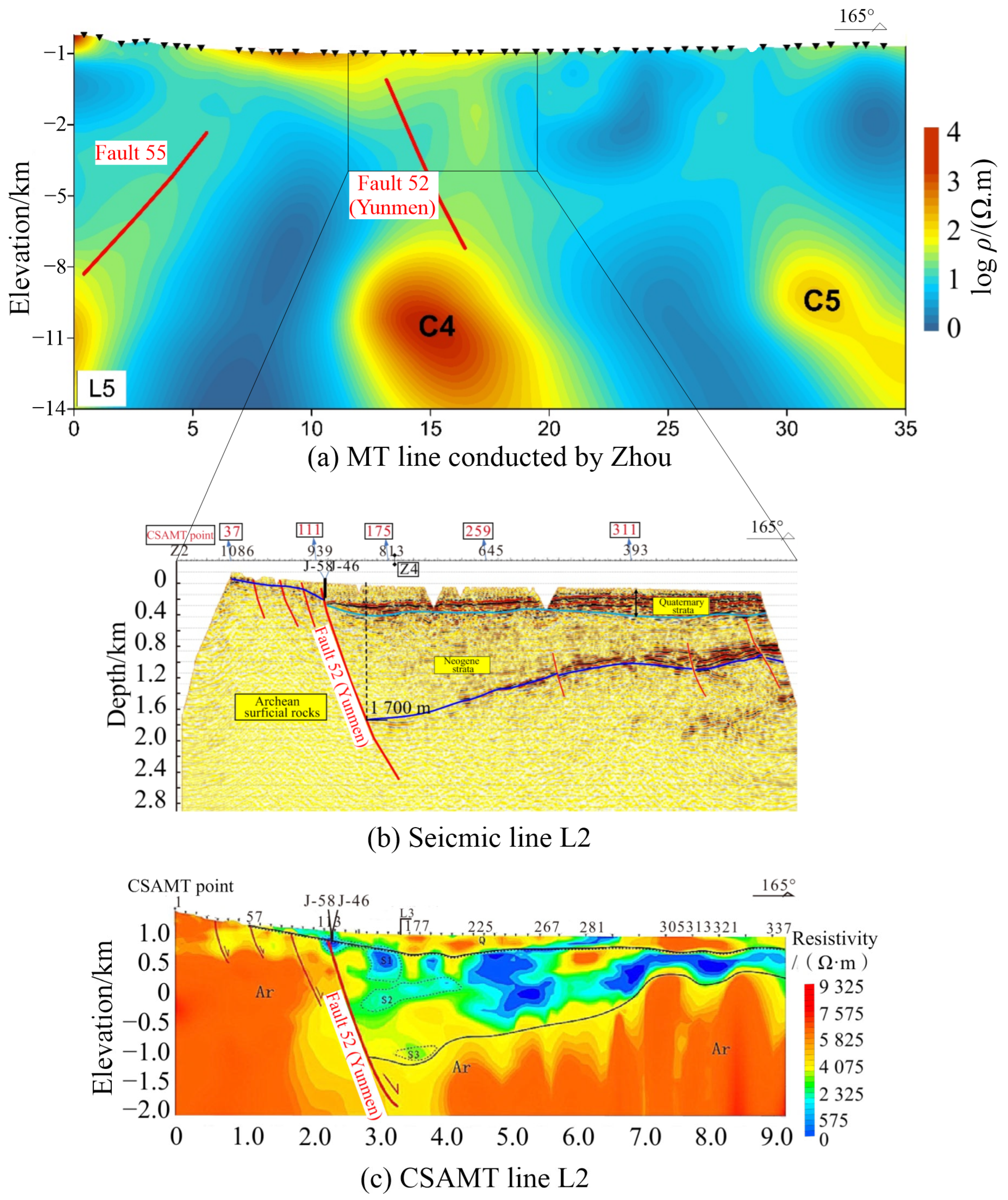
The seismic lines L1, L2, and L4 reflect similar geological characteristics (Figure 3).
(1)
A prominent reflection interface at a depth of approximately 300 m was interpreted as an unconformity between the Quaternary deposits and the Neogene strata (indicated by the light blue line). Another significant reflection interface at a depth of 1600 m was interpreted as an unconformity between the Archean epidermal rocks and Cenozoic sediments (indicated by the dark blue line in Figure 3).
(2)
Profiles L1 and L2 show a sudden interruption of the coherency axis representing the Quaternary strata (highlighted by green boxes in Figure 3a,b). This interruption marks the upper boundary point of the Yunmen Fault (F52). Profile L4 exhibited a continuous reflection interface between the coherency axes of the Neogene and adjacent Archean epidermal rock strata (dark blue line), which gradually disappeared toward the middle of the profile (highlighted in the magenta box in Figure 3c). This location represents the lower boundary point of the Yunmen Fault (F52).
(3)
An observable disruption in the reflection wave coherency axes (indicated by red lines), which was interpreted as evidence of the Yunmen Fault (F52), appears at the center of each profile.

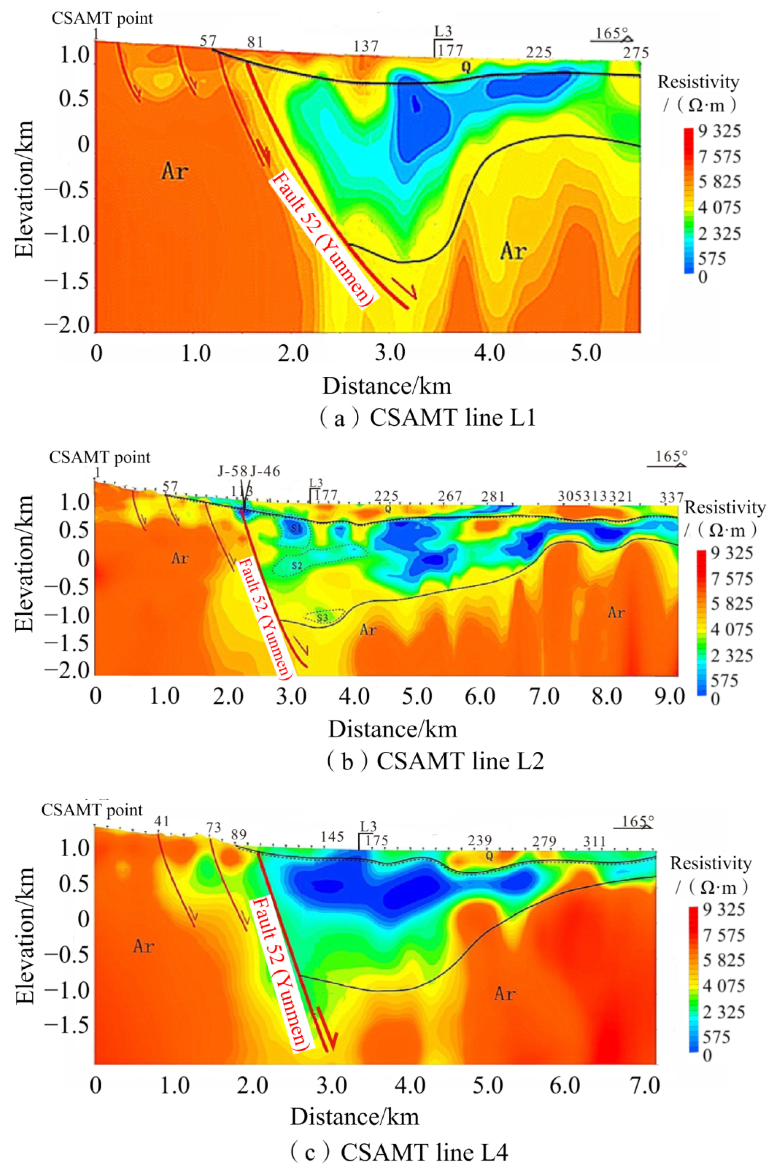
4.2. CSAMT Exploration

The characteristics of the CSAMT profiles and two-dimensional inversion (Figure 4) are as follows:
  • The study area exhibits typical features of a rift basin.
  • The high-resistivity zones at depth on both the left (north) and right (south) sides of the profile correspond to Neoarchean surface rocks (areas enclosed by orange contour lines), whereas the moderate-resistivity zones in the shallow sections are Quaternary cover layers, and the low-resistivity zones in the center are Eocene and Miocene gravel layers, along with altered zones.
  • A noticeable resistivity anomaly in the left-central part of the profile was inferred to be the Yunmen Fault (F52) (indicated by the red line), with an inclination angle of approximately 70°.
  • In profile L2, the low-resistivity zones S1, S2, and S3 (areas delineated by the cyan blue contour lines) may be due to subsurface fluid activity.
Furthermore, a relatively clear reflection interface at depths ranging from 1600 m to 1700 m, which is considered to be the boundary between the Archean surface rocks and the overlying Miocene strata, along with metamorphic and thermally altered layers (indicated by the dark blue line in Figure 5a), were identified in seismic profile L3. An evident offset in the coincident axis of the seismic reflection waves (marked by the red line in Figure 5a) appears to the left of the center, similar to a noticeable anomaly in the resistivity values at the corresponding location in the CSAMT profile (red line in Figure 5b). This feature is interpreted as the Gushan Fault (F51) dipping northeast with an inclination angle of 51°, which is consistent with the regional structural stress field in North China, which is characterized primarily by NE-trending transpressive strike-slip faulting. This supports the inference that the formation of the Datong Basin was influenced by edge dynamics resulting from collisions between the Pacific and Eurasian Plates.

4.3. Borehole Test

Based on the geological survey data and geophysical exploration results of the study area, geothermal Borehole YG-1 was established 600 m north of profile L3 (location shown in Figure 2). The borehole depth was 2682 m; the strata are shown in Figure 6.
Based on the steady-state temperature measurement data from the borehole (Figure 7), the bottom-hole temperature is 140.33 °C, and the average geothermal gradient for the entire wellbore is 5.03 °C/100 m. The geothermal gradient between 200 and 1600 m is 6.05 °C/100 m, which may primarily be due to the ascent of deep high-temperature fluids along fault zones, forming a relatively warmer layer within the more porous and permeable strata of the Quaternary, Miocene, and Eocene layers. The closer it is to the fault zone, the higher the geothermal gradient; conversely, it decreases as the distance to the fault zone increases.
The geothermal gradient notably decreases between 1600 to 2020 m and 2330 to 2510 m, with values of 2.09 and 1.68 °C/100 m, respectively. This reduction was likely caused by thermal convection generated by deep-circulating low-temperature water moving along the unconformity surface of the Yanggao crustal rocks and fractured fault zones. Between 2020 and 2330 m, the geothermal gradient is 5.86 °C/100 m, and between 2510 and 2660 m, it is 5.20 °C/100 m, representing the normal geothermal gradient of a metamorphic rock reservoir.
To obtain the terrestrial heat flow values for the borehole and its surrounding area, the thermal conductivity of a gneiss sample from a depth of 1915 m was measured to be 1.5408 W/(m·°C). The empirical formula for the temperature correction derived by Sass et al. [20] through experimentation is as follows:
q = K r d T / d z
where q represents the terrestrial heat flow value (mW·m−2), Kr represents the thermal conductivity of the rock (W·m−1·°C−1), and dT/dz represents the geothermal gradient (°C·km).
By selecting the geothermal gradients from 2020–2330 m and 2510–2660 m for a weighted average, the calculated terrestrial heat flow value for this gneiss section is 97.0 mW/m2. Considering that the geothermal characteristics were predominantly conductive within the Quaternary, Miocene, Eocene, and Archean sections of this geothermal well, the terrestrial heat flow values for Borehole YG-1 and its surrounding areas could be reasonably estimated.
Borehole YG-1 was subjected to three pumping tests. In the first standard pumping test, the drawdown was 273 m; after 24 h of stable pumping, the water temperature was 81 °C with a specific yield of 0.0056 L/(s·m). The second major drawdown pumping test had a drawdown of 879 m; after 29 h of stable pumping, the water temperature was 101 °C with a specific yield of 0.0045 L/(s·m). The third major drawdown pumping test had a drawdown of 1210 m; after 25 h of stable pumping, the water temperature was again 101 °C with a specific yield of 0.0037 L/(s·m) [21].
The results of the three pumping tests showed a gradual decrease in the specific yield and an increase in the actual recovery time of the water level after pumping. Thus, the deep-confined water in Borehole YG-1 is primarily statically stored with limited recharge sources and mainly relies on groundwater seepage for replenishment, which occurs at a relatively slow rate.
Generally, in areas closer to fault structures, the geothermal gradient and rock thermal conductivity tend to be higher, indicating that the sustainability of geothermal reservoirs in these areas may be poor. In contrast, areas farther from the fault structures have lower geothermal gradients and rock thermal conductivities, suggesting that the sustainability of their geothermal reservoirs may be relatively higher.

5. Discussion

5.1. Heat Source Mechanism and Transfer Method

Previous research has indicated that geothermal resources are primarily distributed in areas with high radiogenic heat production, sedimentary basins, recent volcanic zones, and regions with intense tectonic activity [22,23]. The Datong Basin is characterized by thick accumulations of Cenozoic sediments, which have low thermal conductivity that effectively minimizes the loss of heat from deep sources. The formation and evolution of the Datong Graben suggest that its development may have been a result of the combined effects of the India–Eurasia and Pacific–Eurasia plate collisions, leading to the partial transformation of weak structural zones in the central and western parts of the North China Craton, lithospheric thinning, and upwelling of the asthenosphere [24]. The alteration and thinning of the lithosphere mainly manifests as deep magmatic activity and shallow extensional movement [25]. Since the Cenozoic, the continuous extension and subsidence of the Datong Basin have led to crustal thinning and mantle uplift, resulting in bottom-up thermal erosion. Partial melting of the upper mantle transfers heat to the crust, causing continuous heating, reaching the crustal fracture strength of the tectonic stress field and leading to a lateral extension. Mantle materials erupted along faults or structurally weak zones, forming the Datong Volcanic Group, whereas unerupted magma formed magma chambers that migrated northeast. Frequent seismic activity in the Datong Basin is closely related to the formation of geothermal resources. Seismic movements activate fault fractures and allow deeper heat source materials to flow more easily upward to shallower levels, thus creating geothermal anomalies [26].
The study area is located approximately 30 km from the Datong Volcanic Group and adjacent to the large Yunmenshan Mountain Front Fault in the north, an area of intense Cenozoic volcanic activity. According to Zhou [27], a low-resistance layer and low-resistance bodies exist within the upper crust of the study area (buried at depths of 8–12 km), likely representing a molten or partially molten magma chamber that shares a common origin with the magma of the Datong Volcanic Group and has not yet cooled (Figure 8a; C4 and C5 denote the magma chambers).
In this study, the seismic and CSAMT inversion data (Figure 8b,c) indicate that Fault 52 (Yunmen) is composed of a series of steeply dipping normal faults arranged in steps. Under the superimposed effect of the normal fault dipping toward the NEE of Gushan Village, heat is conducted along the fault zone or through high-conductivity metamorphic rock strata to the shallow surface, forming geothermal anomalies. This process provided a stable heat source for the formation of geothermal resources in the study area. Fault 52 is shown in Figure 8a and corroborates the conclusions of Zhou [27].

5.2. Heat Reservoir and Caprock

Based on the findings from Borehole YG-1, the high-temperature geothermal reservoirs in the study area consist mainly of deep aquifer formations and deep Archean metamorphic rocks associated with the Yunmenshan Mountain Front deep fault and its derivative fractures, all located at depths greater than 1500 m. The caprock comprises the upper Quaternary, Miocene, and Eocene gravel layers, clay layers, and thermally altered zones [22].

5.3. Geothermal System Model

Based on the two-dimensional seismic and AMT data inversion from the eastern geothermal region of the Datong Basin, the electrical structure model of the Yanggao-Tianzhen area can be divided into convective- and conductive-type geothermal system models. In the northern regions close to the large Yunmenshan Fault, there are clear electrical and structural characteristics of convective-type high-temperature geothermal systems. In contrast, the southern regions near the basin exhibit typical electrical structural features of a conductive-type geothermal system.
In the northern Yunmenshan mountainous area, atmospheric precipitation and surface water migrate downwards and are heated by a heat reservoir as they circulate to depths of 1600 m or deeper. They then surge upward along high-permeability pathways, such as the intersection of the Yunmenshan fault zone and the Gushan Village fault and their vicinity, mix with shallow cold water, and move laterally through the Quaternary reservoir, forming a series of hot spring wells. As shown in Figure 2, the hot spring geothermal wells are arranged linearly along the NEE-trending concealed Yunmenshan Fault and the NNW-trending Gushan Village normal faults. The hottest springs, such as the Baidu Hot Spring (J-46) and J-58, are located at the intersection of these two faults, whereas the temperatures of the springs farther from the intersection exhibit a clear decreasing trend.
Sections S1, S2, and S3 in CSAMT survey line L2 indicate medium-low resistivity caused by the influence of low-temperature fluids. Physical well logging and steady-state temperature measurement data from Borehole YG-1 also show the presence of low-temperature water convection within the high-temperature geothermal fluid, providing strong evidence of the existence of a convective-type geothermal system in the study area.
In addition, CSAMT survey line L3 displayed three distinct electrical layers. The Archean basement strata are located below the Cenozoic cover layer and exhibit high thermal conductivity. Combined with the seismic and two-dimensional seismic results from the Yanggao-Tianzhen area, the heat released by uncooled magma chambers in the middle-upper crust and deeper mantle magma chambers is conducted along the Yunmenshan fault zone or through high-conductivity metamorphic basement strata to the shallow geothermal reservoir. The clay layer within the Quaternary caprock effectively prevents heat loss. The high geothermal gradient reflected in the temperature data from Borehole YG-1 provides evidence of a conductive-type geothermal system in metamorphic rock strata. In summary, the high-temperature geothermal system in the study area is characterized as both convective and conductive (Figure 9).

6. Conclusions

In this study, seismic and CSAMT methods were employed to investigate the geothermal resources in northern Shanxi Province, China. The following conclusions were drawn.
(1)
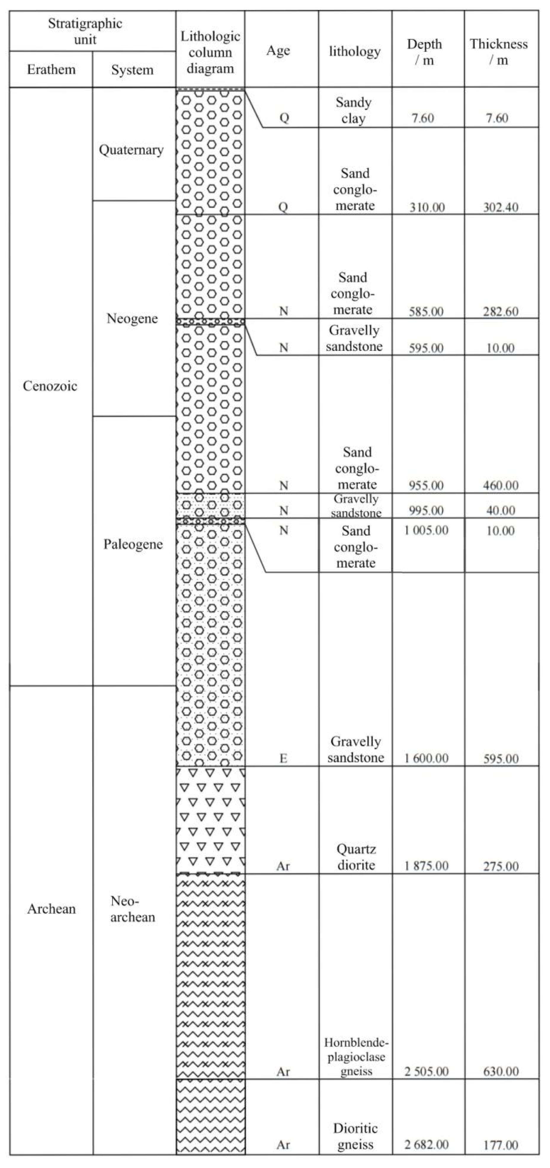
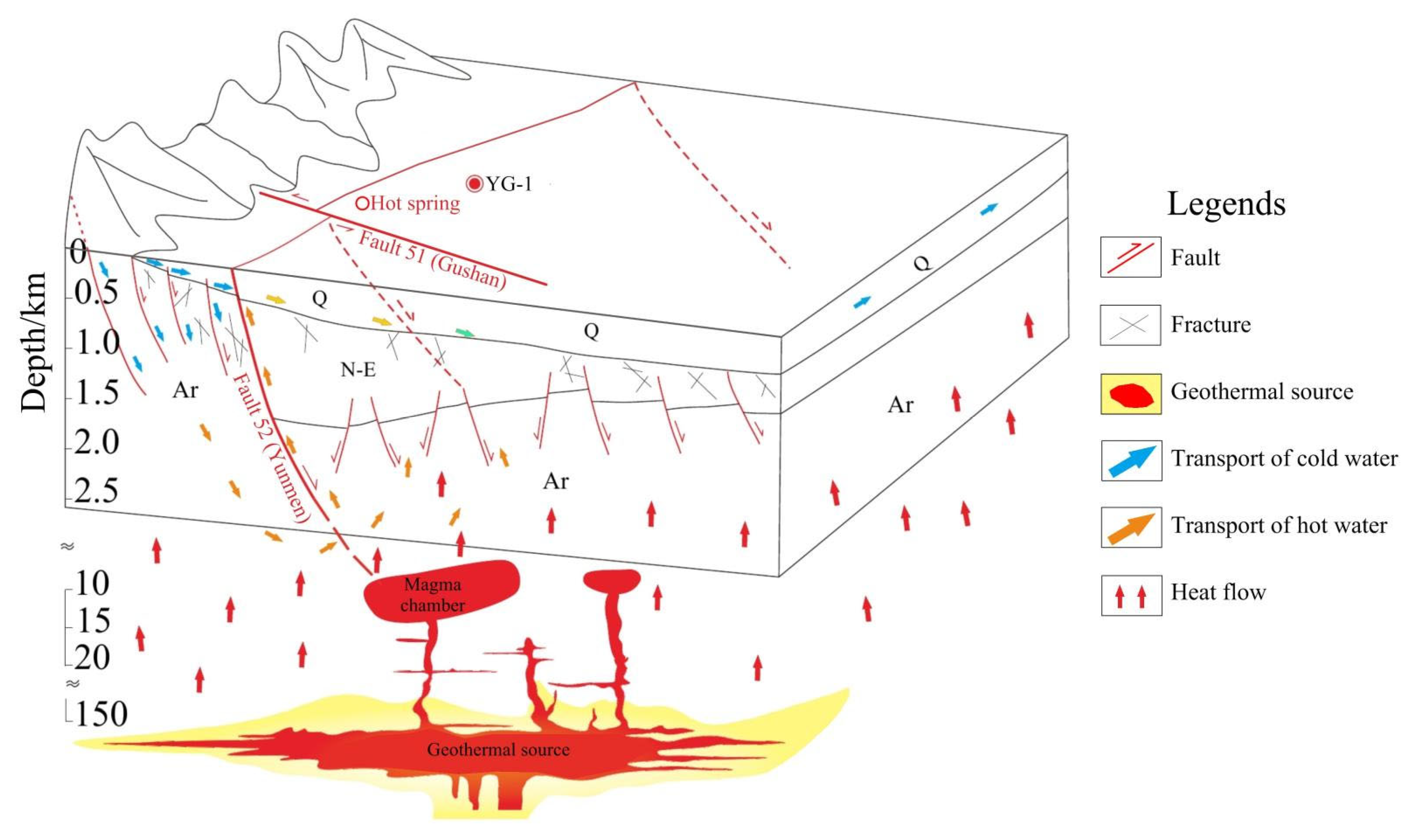
The stratigraphy of the study area can be divided into three segments from top to bottom: the first segment is the caprock of the geothermal reservoir, comprising Quaternary deposits; the second segment is the thermally altered layer, primarily consisting of Miocene and Eocene gravel; and the third segment is the Archean metamorphic rock geothermal reservoir.
(2)
The Yunmenshan Mountain Front Fault Zone and Gushan Village Normal Fault are the primary heat-controlling structures. The direct heat source could be an uncooled magmatic chamber in the middle of the upper crust. Under the influence of extensional tectonic stress, partial melts from the upper mantle ascend along deep, large faults, or structurally weak zones to form magma chambers. The heat released from these uncooled magma chambers and deeper mantle magma reservoirs is transmitted to the shallow surface along fracture zones or through metamorphic rock strata with high thermal conductivity, thereby creating geothermal anomalies.
(3)
The high-temperature geothermal system in the northern Shanxi Province exhibits both convective and conductive characteristics. Atmospheric precipitation and low-temperature surface water infiltrate downwards and are heated by geothermal reservoirs. The heated water then ascends along fault zones and spreads beneath the Quaternary caprock, forming a hydrothermal circulation system.
These findings further our understanding of the geothermal resources in the region and provide a reference for the future development of geothermal energy technologies.

Author Contributions

Conceptualization, Z.L.; methodology, Y.Y., H.L. and Y.M.; software, Y.Y.; validation, Y.Y.; formal analysis, Y.M.; writing—original draft preparation, Z.L. and Y.Y.; writing—review and editing, Z.L., Y.Y., H.L., Y.M. and Y.C.; supervision, H.L. and Y.M. All authors have read and agreed to the published version of the manuscript.

Funding

This research was funded by the Natural Science Foundation of Guangxi (grant numbers Gui Ke AD23026260 and Gui Ke AB24010021), the Department Preliminary Project of Guangxi Bureau of Geology and Minerals (grant number [2024]67), the Inclusive Supporting Foundation for Qingmiao Talents of Guangxi, and the Basic Ability Improvement Project of Young and Middle-aged Teachers in Universities of Guangxi: Research on Three-Dimensional Forward and Inverse Modeling Methods for Frequency-Domain Controlled-Source Electromagnetic Exploration for Karst (grant number 2025KY1442). The APC was funded by the Natural Science Foundation of Guangxi (grant numbers Gui Ke AD23026260 and Gui Ke AB24010021).

Data Availability Statement

The datasets presented in this article are not readily available because the data are part of an ongoing study. Requests to access the datasets should be mailed to the corresponding authors directly.

Conflicts of Interest

Youliang Cai is from Guangxi Shuangke Construction Engineering Consulting Co., Ltd. The remaining authors declare that the research was conducted in the absence of any commercial or financial relationships that could be construed as a potential conflict of interest.

References

  1. Hill, M.; Dehouche, Z. A comparative analysis of the Effectiveness of aquifer Thermal Energy storage in expeditionary campaign infrastructure. Appl. Therm. Eng. 2017, LI, 114271–114278. [Google Scholar] [CrossRef]
  2. Liu, Y.; Hou, J.; Zhao, H.; Liu, X.; Xia, Z. A method to recover natural gas hydrates with geothermal energy conveyed by CO2. Energy 2018, 144, 265–278. [Google Scholar] [CrossRef]
  3. Zhu, J.; Hu, K.; Lu, X.; Huang, X.; Liu, K.; Wu, X. A review of geothermal energy resources, development, and applications in China: Current status and prospects. Energy 2015, 93, 466–483. [Google Scholar] [CrossRef]
  4. Baikadamova, A.M. The use of geothermal energy using the example of the Zharkent geothermal water deposit. Eng. J. Satbayev. Univ. 2024, 146, 41–46. [Google Scholar] [CrossRef]
  5. Mnzool, M.; Al-Mukhtar, A.; Majeed, A.J.; Arafat, A.; Gomaa, E. Simulation and performance characteristics of rock with borehole using Visual Finite Element Analysis. Min. Miner. Depos. 2024, 18, 33–41. [Google Scholar] [CrossRef]
  6. Shi, Y.; Song, X.; Li, J. Numerical investigation on heat extraction performance of AMultilateral-well enhanced geothermal system with A discrete fracture network. Fuel 2019, 244, 207–226. [Google Scholar] [CrossRef]
  7. Zhang, D.Z.; Ma, Y.Q.; Su, Y.Q. Study on the Calculation of Geothermal Fluids Recoverable Quantity and the Distribution Law of Karst Geothermal Reservoirs in Hebei Plain; Geological Survey of China: Beijing, China, 2018; Volume 5, pp. 78–85. [Google Scholar]
  8. Dai, M.G.; Lei, H.F.; Hu, J.G.; Guo, X.F.; Ma, P.P.; Zhang, J. Evaluation of recoverable geothermal resources and development parameters of Mesoproterozoic thermal reservoir with the top surface depth of 3500 m and shallow in Xiong’an new area. Acta Geol. Sin. 2019, 93, 2874–2888. [Google Scholar]
  9. Zhu, X.; Wang, G.; Wang, X.; Qi, S.; Ma, F.; Zhang, W.; Zhang, H. Hydrogeochemical and isotopic analyses of deep geothermal fluids in the Wumishan Formation in Xiong’an new area, China. Lithosphere 2022, 2021, 2576752. [Google Scholar] [CrossRef]
  10. Pei, F.G.; He, M.X.; Fang, H.; Wang, X.B.; Qiu, G.; Zhang, X.; Lu, Q.; Zhang, Y.; Yuan, Y.; Wang, X. Evaluation of deep geothermal resources potential in the Songliao Basin based on the fuzzy mathematics. Earth Sci. 2023, 48, 1058–1079. [Google Scholar]
  11. Zhao, J.; Guo, Q.H. Geothermal resources evaluation based on 3D geological modeling: The case of Shidian geothermal area. Earth Sci. 2023, 48, 1107–1117. [Google Scholar]
  12. Luo, Q.; Li, C.; Ren, G. The late quaternary activity features and slip rate of the Yanggao-Tianzhen fault. Seismol. Geol. 2020, 42, 399–413. [Google Scholar]
  13. Min, C.; Dong, S.; Wei, S.; Zhou, T.; Chen, L.; Chen, X. Structural analysis on the formation mechanism of Datong Basin. Geol. Rev. 2015, 61, 1235–1247. [Google Scholar]
  14. Shi, W.; Cen, M.; Chen, L.; Wang, Y.; Chen, X.; Li, J.; Chen, P. Evolution of the Late Cenozoic tectonic stress regime in the Shanxi Rift, central North China Plate inferred from new fault kinematic analysis. J. Asian Earth Sci. 2015, 114, 54–72. [Google Scholar] [CrossRef]
  15. Song, M.; Yong, Z.; Can, G.E. Relocation of small to moderate earthquakes in Shanxi Province and its relation to the seismogenic structures. Chin. J. Geophys. 2012, 55, 513–525. [Google Scholar]
  16. He, L.; Guo, Z.; Chen, J.; Yang, Y. Seismic imaging of a magma chamber and melt recharge of the dormant Datong volcanoes. Earth Space Sci. 2021, 8, e2021. [Google Scholar] [CrossRef]
  17. Dou, S. The relation between Quanternary volcano and earthquake activity in the Datong Basin. Bol. Inst. Crustal Dyn. 1996, 22, 52–58. [Google Scholar]
  18. Liu, J.; Wang, G.; Jian, X.; Zhu, C.; Hu, X.; Yuan, X.; Wang, C. Tectono-thermal mechanism and hydrocarbon generation action in the north Yellow Sea Eastern Sub-basin. Earth Sci. Front. 2024, 31, 206–218. [Google Scholar]
  19. Wang, G.L.; Zhang, W.; Liang, J.Y.; Lin, W.J.; Wang, W.L. Evaluation of geothermal resources potential in China. Acta Geosci. Sin. 2017, 38, 449–459. [Google Scholar]
  20. Sass, J.H.; Lachenbruch, A.H.; Moses, T.H.; Morgan, P. Heat flow from a scientific research well at Cajon Pass, California. J. Geophys. Res. 1992, 97, 5017–5030. [Google Scholar] [CrossRef]
  21. Yang, Y.; Li, Z.; Wang, H. Experimental study on the influence of ion components in geothermal water on scaling behavior. Energies 2025, 18, 946. [Google Scholar] [CrossRef]
  22. Li, C.; Luo, J.; Fan, C.; Li, S.; Wu, S.; Lei, C.; Song, K. Impact of high thermal setting and fluid activities on sandstone compaction: A case study of the Baiyun Sag in the Pearl River Mouth Basin (northern South China Sea). Geofluids 2021, 2021, 6658729. [Google Scholar] [CrossRef]
  23. Gan, H.; Wang, G.; Lin, W.; Wang, X.; Feng, M.; Xi, Z. Research on the occurrence types and genetic models of hot dry rock resources in China. Sci. Technol. Rev. 2015, 33, 22–27. [Google Scholar]
  24. Lu, C.; Lin, W.; Gan, H.; Liu, F.; Wang, G. Occurrence types and genesis models of hot dry rock resources in China. Environ. Earth Sci. 2017, 76, 646. [Google Scholar] [CrossRef]
  25. Zhai, M. Cratonization and the Ancient North China Continent: A summary and review. Sci. China Earth Sci. 2011, 54, 1110–1120. [Google Scholar] [CrossRef]
  26. Zhu, R.; Xu, Y.; Zhu, G.; Zhang, H.; Xia, Q.; Zheng, T. Destruction of the North China craton. Sci. China Earth Sci. 2012, 55, 1565–1587. [Google Scholar] [CrossRef]
  27. Zhou, W. Electrical Structure of Geothermal Area in Northeast of Datong Basin; China University of Geosciences: Wuhan, China, 2021. [Google Scholar]
Figure 1. (a) Location of the study area. (b) Earthquake distribution around the study area (modified from Meiqin et al. [15]). “Figure 2” labeled in Figure 1b indicates the specific location of the study area in northern Shanxi Province, which is expanded in Figure 2.
Energies 18 01494 g001
Figure 2. Lithology and survey line distributions.
Energies 18 01494 g002
Figure 3. Survey profiles of seismic lines L1, L2, and L4.
Energies 18 01494 g003
Figure 4. Survey profiles of controlled-source audio-frequency magnetotelluric (CSAMT) lines L1, L2, and L4.
Energies 18 01494 g004
Figure 5. Seismic and CSMAT lines along profile L3.
Energies 18 01494 g005
Figure 6. Stratigraphic column of Borehole YG-1.
Energies 18 01494 g006
Figure 7. Static and steady temperature measurement curve of Borehole YG-1.
Energies 18 01494 g007
Figure 8. Magnetotelluric survey line (a), seismic line L2 (b), and CSAMT line 2 (c) (modified from Zhou [22]).
Energies 18 01494 g008
Figure 9. Three-dimensional geothermal system model of the study area.
Energies 18 01494 g009
Disclaimer/Publisher’s Note: The statements, opinions and data contained in all publications are solely those of the individual author(s) and contributor(s) and not of MDPI and/or the editor(s). MDPI and/or the editor(s) disclaim responsibility for any injury to people or property resulting from any ideas, methods, instructions or products referred to in the content.

