

Soil Erosion Risk Analysis in the Ría de Arosa (Pontevedra, Spain) Using the RUSLE and GIS Techniques


Abstract
1. Introduction
Study Area
2. Materials and Methods
2.1. Potential Erosion Mapping
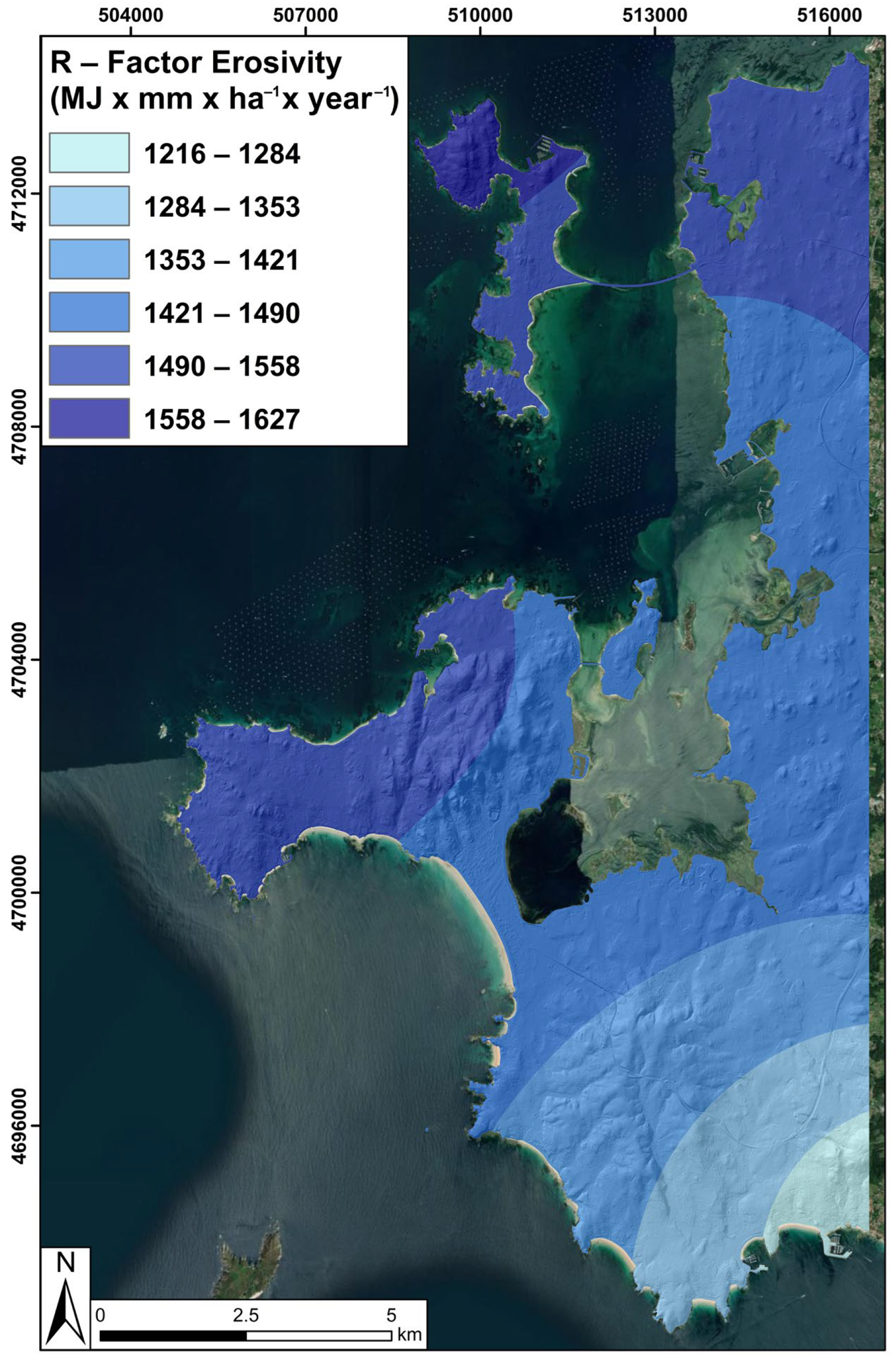
2.1.1. R-Factor: Rain Erosivity
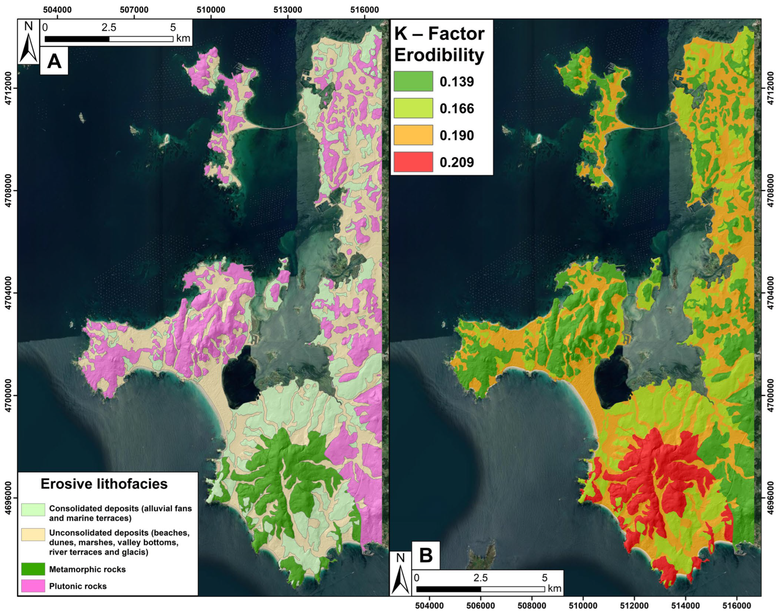
2.1.2. K-Factor: Soil Erodibility
2.1.3. LS-Factor: Topographic Factor
2.2. Real Erosion Mapping
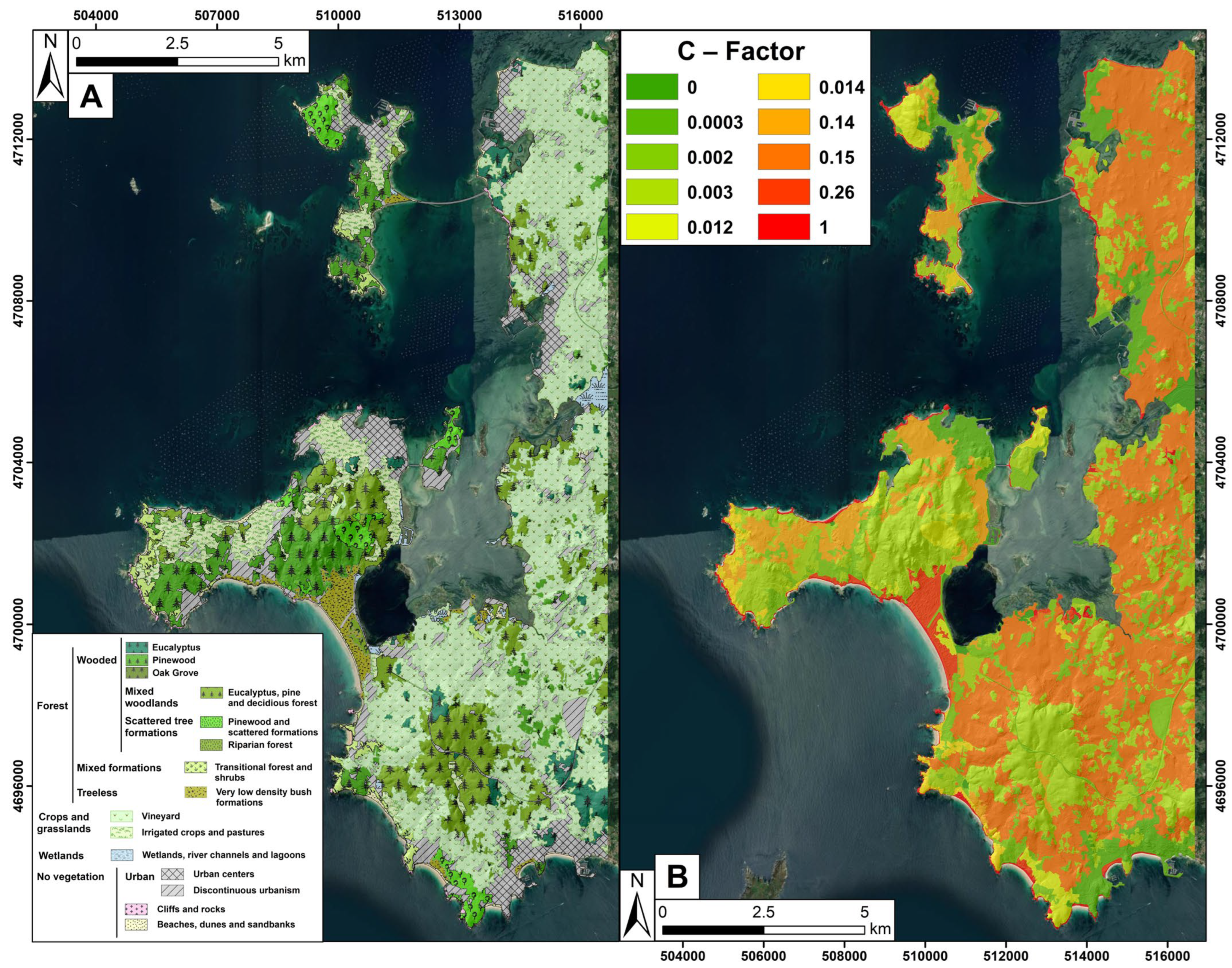
2.2.1. C-Factor: Soil Cover Factor
2.2.2. P-Factor: Soil Conservation Practices
3. Results
3.1. Potential Erosion
3.1.1. R-Factor Values
3.1.2. K-Factor Values
3.1.3. LS-Factor Values
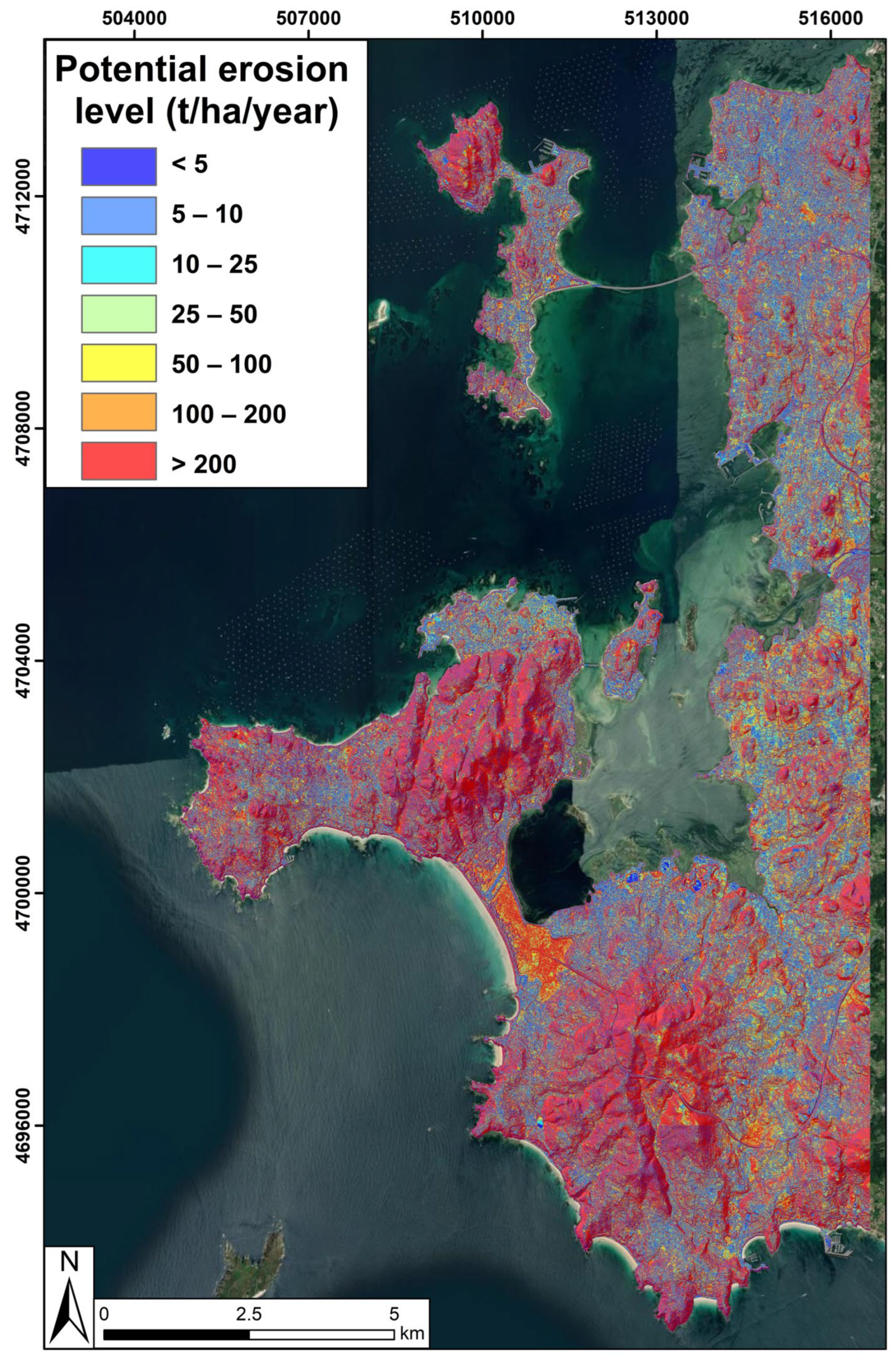
3.1.4. Potential Erosion Risk of SE Ría de Arosa
3.2. Real Erosion
3.2.1. C-Factor Values
3.2.2. Real Erosion Risk of SE Ría de Arosa
4. Discussion
4.1. Comparison of Potential and Actual Erosion Cartographies
4.2. Analysis of Erosion Risks in Relation to Land Uses
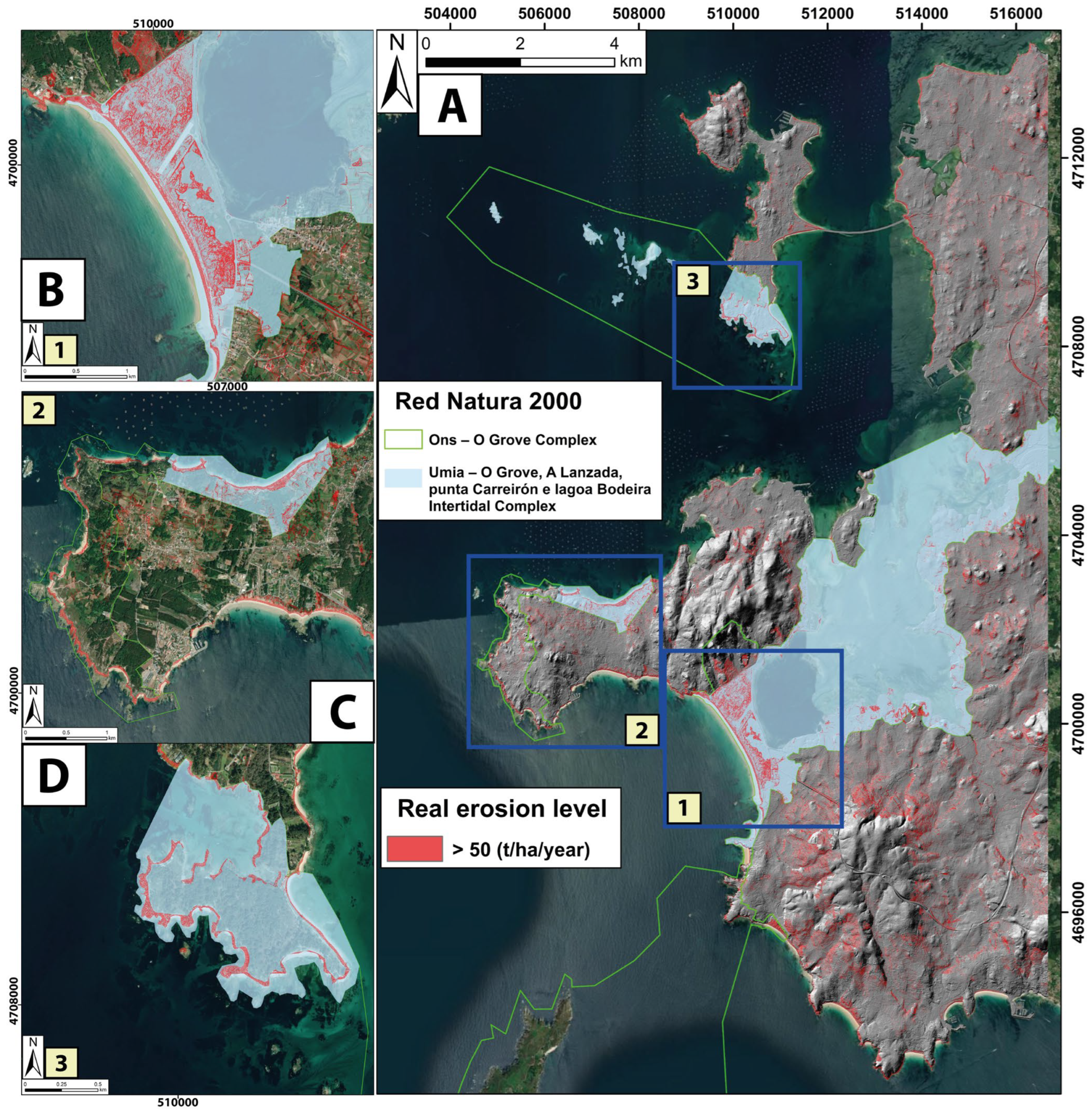
4.3. Evaluation of Erosion in Protected Natural Areas
4.4. Corrective Measures and Mitigation Strategies for Soil Erosion in the SE of the Ría de Arosa
5. Conclusions
- Areas with severe to extreme erosion values, with soil loss exceeding 50 t/ha/year and reaching more than 200 t/ha/year, are primarily located in coastal zones with steep slopes, poorly developed soils, and sparse vegetation. High erosion values are especially prevalent in cliff areas, steep slopes, and regions with poorly consolidated soils, such as dunes and beaches. Recommended measures for these areas include the installation of metal mesh fences and reforestation with native plant species to stabilize the soil and reduce sediment loss. Additionally, it is suggested to conduct further studies on wind and coastal erosion (dune systems and cliffs) in these problematic areas.
- Erosion values in areas ranging between 10.1 and 50 t/ha/year include cultivated lands such as vineyards and transition zones between forests and grasslands. Additionally, some vineyards in the study area also exhibit severe to extreme erosion values due to steep terrain and insufficient soil protection. Recommended measures include the construction of agricultural terraces and the use of straw mulch to improve soil stability and mitigate erosion.
- Areas with erosion values up to 10 t/ha/year have better-developed soils and denser vegetation, providing good protection against erosion. Despite the lower erosion levels, maintaining conservation practices is crucial to preserving soil stability. Reforestation with native species is particularly important during post-fire periods when soil erosion rates are elevated.
Author Contributions
Funding
Informed Consent Statement
Data Availability Statement
Acknowledgments
Conflicts of Interest
References
- Martínez, M.L.; Intralawan, A.; Vázquez, G.; Pérez-Maqueo, O.; Sutton, P.; Landgrave, R. The Coasts of Our World: Ecological, Economic and Social Importance. Ecol. Econ. 2007, 63, 254–272. [Google Scholar] [CrossRef]
- Burke, L.; Kura, Y. Pilot Analysis of Global Ecosystems: Coastal Ecosystems; World Resources Institute: Washington, DC, USA, 2000. [Google Scholar]
- Li, K.; Zhang, L.; Chen, B.; Zuo, J.; Yang, F.; Li, L. Analysis of China’s Coastline Changes during 1990–2020. Remote Sens. 2023, 15, 981. [Google Scholar] [CrossRef]
- Jin, X.; Luan, W.; Yang, J.; Yue, W.; Wan, S.; Yang, D.; Xiao, X.; Xue, B.; Dou, Y.; Lyu, F.; et al. From the Coast to the Interior: Global Economic Evolution Patterns and Mechanisms. Humanit. Soc. Sci. Commun. 2023, 10, 723. [Google Scholar] [CrossRef]
- Lee, H.; Calvin, K.; Dasgupta, D.; Krinner, G.; Mukherji, A.; Thorne, P.; Trisos, C.; Romero, J.; Aldunce, P.; Barret, K. IPCC 2023: Climate Change 2023: Synthesis Report, Summary for Policymakers. In Contribution of Working Groups I, II and III to the Sixth Assessment Report of the Intergovernmental Panel on Climate Change; Core Writing Team, Lee, H., Romero, J., Eds.; IPCC: Geneva, Switzerland, 2023. [Google Scholar]
- Nicholls, R.J.; Lincke, D.; Hinkel, J.; Brown, S.; Vafeidis, A.T.; Meyssignac, B.; Hanson, S.E.; Merkens, J.-L.; Fang, J. A Global Analysis of Subsidence, Relative Sea-Level Change and Coastal Flood Exposure. Nat. Clim. Chang. 2021, 11, 338–342. [Google Scholar] [CrossRef]
- Eekhout, J.P.C.; De Vente, J. Global Impact of Climate Change on Soil Erosion and Potential for Adaptation through Soil Conservation. Earth-Sci. Rev. 2022, 226, 103921. [Google Scholar] [CrossRef]
- Pal, S.C.; Chakrabortty, R.; Towfiqul Islam, A.R.M.; Roy, P.; Chowdhuri, I.; Saha, A.; Islam, A.; Costache, R.; Alam, E. Land Use and Climate Change-Induced Soil Erosion Mapping in a Sub-Tropical Environment. Geomat. Nat. Hazards Risk 2023, 14, 2270129. [Google Scholar] [CrossRef]
- Mohammed, S.; Abdo, H.G.; Szabo, S.; Pham, Q.B.; Holb, I.J.; Linh, N.T.T.; Anh, D.T.; Alsafadi, K.; Mokhtar, A.; Kbibo, I.; et al. Estimating Human Impacts on Soil Erosion Considering Different Hillslope Inclinations and Land Uses in the Coastal Region of Syria. Water 2020, 12, 2786. [Google Scholar] [CrossRef]
- O’Riordan, R.; Davies, J.; Stevens, C.; Quinton, J.N.; Boyko, C. The Ecosystem Services of Urban Soils: A Review. Geoderma 2021, 395, 115076. [Google Scholar] [CrossRef]
- Food and Agriculture Organization of the United Nations. Status of the World’s Soil Resources: Technical Summary; Food and Agriculture Organization of the United Nations: Rome, Italy, 2015. [Google Scholar]
- Montanarella, L.; Pennock, D.J.; McKenzie, N.; Badraoui, M.; Chude, V.; Baptista, I.; Mamo, T.; Yemefack, M.; Singh Aulakh, M.; Yagi, K.; et al. World’s Soils Are under Threat. Soil 2016, 2, 79–82. [Google Scholar] [CrossRef]
- Borrelli, P.; Robinson, D.A.; Fleischer, L.R.; Lugato, E.; Ballabio, C.; Alewell, C.; Meusburger, K.; Modugno, S.; Schütt, B.; Ferro, V.; et al. An Assessment of the Global Impact of 21st Century Land Use Change on Soil Erosion. Nat. Commun. 2017, 8, 2013. [Google Scholar] [CrossRef]
- Borrelli, P.; Robinson, D.A.; Panagos, P.; Lugato, E.; Yang, J.E.; Alewell, C.; Wuepper, D.; Montanarella, L.; Ballabio, C. Land Use and Climate Change Impacts on Global Soil Erosion by Water (2015–2070). Proc. Natl. Acad. Sci. USA 2020, 117, 21994–22001. [Google Scholar] [CrossRef]
- Lal, R. Soil Carbon Sequestration Impacts on Global Climate Change and Food Security. Science 2004, 304, 1623–1627. [Google Scholar] [CrossRef]
- O’Neal, M.R.; Nearing, M.A.; Vining, R.C.; Southworth, J.; Pfeifer, R.A. Climate Change Impacts on Soil Erosion in Midwest United States with Changes in Crop Management. CATENA 2005, 61, 165–184. [Google Scholar] [CrossRef]
- Montgomery, D.R. Soil Erosion and Agricultural Sustainability. Proc. Natl. Acad. Sci. USA 2007, 104, 13268–13272. [Google Scholar] [CrossRef]
- Cook, H.L. The Nature and Controlling Variables of the Water Erosion Process. Soil Sci. Soc. Am. J. 1937, 1, 487–494. [Google Scholar] [CrossRef]
- Kirkby, M.J.; Morgan, R.P.C. Soil Erosion; Wiley: New York, NY, USA, 1981; p. 312. [Google Scholar]
- Morgan, R.P.C.; Nearing, M. Handbook of Erosion Modelling; John Wiley & Sons: Hoboken, NJ, USA, 2016. [Google Scholar]
- Wischmeier, W.H.; Smith, D.D. Predicting Rainfall Erosión Losses: A Guide to Conservation Planning (No. 537); Department of Agriculture, Science and Education Administration: Washinton, DC, USA, 1978. [Google Scholar]
- Laflen, J.M.; Lane, L.J.; Foster, G.R. WEPP: A New Generation of Erosion Prediction Technology. J. Soil Water Conserv. 1991, 46, 34. [Google Scholar]
- Santhi, C.; Arnold, J.G.; Williams, J.R.; Dugas, W.A.; Srinivasan, R.; Hauck, L.M. Validation of the Swat Model on a Large Rwer Basin with Point and Nonpoint Sources. J. Am. Water Resour. Assoc. 2001, 37, 1169–1188. [Google Scholar] [CrossRef]
- Lufafa, A.; Tenywa, M.M.; Isabirye, M.; Majaliwa, M.J.G.; Woomer, P.L. Prediction of Soil Erosion in a Lake Victoria Basin Catchment Using a GIS-Based Universal Soil Loss Model. Agric. Syst. 2003, 76, 883–894. [Google Scholar] [CrossRef]
- Parveen, R.; Kumar, U. Integrated Approach of Universal Soil Loss Equation (USLE) and Geographical Information System (GIS) for Soil Loss Risk Assessment in Upper South Koel Basin, Jharkhand. J. Geogr. Inf. Syst. 2012, 4, 588–596. [Google Scholar] [CrossRef]
- Haokip, P.; Khan, M.A.; Choudhari, P.; Kulimushi, L.C.; Qaraev, I. Identification of Erosion-Prone Areas Using Morphometric Parameters, Land Use Land Cover and Multi-Criteria Decision-Making Method: Geo-Informatics Approach. Environ. Dev. Sustain. 2022, 24, 527–557. [Google Scholar] [CrossRef]
- Renard, K.G.; Foster, G.R.; Weesies, G.A. Predicting Soil Erosion by Water: A Guide to Conservation Planning with the Revised Universal Soil Loss Equation (RUSLE); USDA Agricultural Handbook: Washington, DC, USA, 1997; p. 404.
- Benavidez, R.; Jackson, B.; Maxwell, D.; Norton, K. A Review of the (Revised) Universal Soil Loss Equation ((R)USLE): With a View to Increasing Its Global Applicability and Improving Soil Loss Estimates. Hydrol. Earth Syst. Sci. 2018, 22, 6059–6086. [Google Scholar] [CrossRef]
- Terranova, O.; Antronico, L.; Coscarelli, R.; Iaquinta, P. Soil Erosion Risk Scenarios in the Mediterranean Environment Using RUSLE and GIS: An Application Model for Calabria (Southern Italy). Geomorphology 2009, 112, 228–245. [Google Scholar] [CrossRef]
- Martínez-Graña, A.; Carrillo, J.; Lombana, L.; Criado, M.; Palacios, C. Mapping the Risk of Water Soil Erosion in Larrodrigo (Salamanca, Spain) Using the RUSLE Model and A-DInSAR Technique. Agronomy 2021, 11, 2120. [Google Scholar] [CrossRef]
- Merchán, L.; Martínez-Graña, A.M.; Alonso Rojo, P.; Criado, M. Water Erosion Risk Analysis in the Arribes Del Duero Natural Park (Spain) Using RUSLE and GIS Techniques. Sustainability 2023, 15, 1627. [Google Scholar] [CrossRef]
- Sifi, S.; Aydi, A.; Bouamrane, A.; Zaghdoudi, S.; Gasmi, M. Appraisal of Soil Erosion Risk in Northeastern Tunisia Using Geospatial Data and Integrated Approach of RUSLE Model and GIS. J. Earth Syst. Sci. 2024, 133, 67. [Google Scholar] [CrossRef]
- Fernández, C.; Vega, J.; Jiménez, E.; Vieira, D.; Merino, A.; Ferreiro, A.; Fonturbel, T. Seeding and Mulching+ Seeding Effects on Post-fire Runoff, Soil Erosion and Species Diversity in Galicia (NW Spain). Land Degrad. Dev. 2012, 23, 150–156. [Google Scholar] [CrossRef]
- Vieira, D.C.S.; Borrelli, P.; Jahanianfard, D.; Benali, A.; Scarpa, S.; Panagos, P. Wildfires in Europe: Burned Soils Require Attention. Environ. Res. 2023, 217, 114936. [Google Scholar] [CrossRef]
- Shakesby, R.A. Post-Wildfire Soil Erosion in the Mediterranean: Review and Future Research Directions. Earth-Sci. Rev. 2011, 105, 71–100. [Google Scholar] [CrossRef]
- Moody, J.A.; Shakesby, R.A.; Robichaud, P.R.; Cannon, S.H.; Martin, D.A. Current Research Issues Related to Post-Wildfire Runoff and Erosion Processes. Earth-Sci. Rev. 2013, 122, 10–37. [Google Scholar] [CrossRef]
- Chazarra Bernabé, A.; Lorenzo Mariño, B.; Romero Fresneda, R.; Moreno García, J.V. Evolución de Los Climas de Köppen en España En El Periodo 1951–2020; Agencia Estatal de Meteorología: Madrid, Spain, 2022. [Google Scholar] [CrossRef]
- Llana-Fúnez, S.; Marcos, A. The Malpica–Lamego Line: A Major Crustal-Scale Shear Zone in the Variscan Belt of Iberia. J. Struct. Geol. 2001, 23, 1015–1030. [Google Scholar] [CrossRef]
- Martínez-Graña, A.M.; Arias, L.; Goy, J.L.; Zazo, C.; Silva, P. Geomorphology of the mouth of the Arosa estuary (Coruña-Pontevedra, Spain). J. Maps 2017, 13, 554–562. [Google Scholar] [CrossRef]
- Nieto, C.E.; Martínez-Graña, A.M.; Merchán, L. Landscape Analysis and Coastal Planning: Ría de Arosa (Pontevedra, Spain). Land 2024, 13, 645. [Google Scholar] [CrossRef]
- Macías, F.; Calvo de Anta, R. Los Suelos. In Atlas de Galicia; Sociedade para o Desenvolvemento Comarcal de Galicia, Conselleria de Presidencia, Xunta de Galicia: Santiago de Compostela, Spain, 2001; pp. 173–218. [Google Scholar]
- García-Rodeja, E.; Nóvoa-Muñoz, J.C.; Pontevedra-Pombal, X. Soils of Galicia. In The Environment in Galicia: A Book of Images: Galician Environment Through Images; Núñez-Delgado, A., Álvarez-Rodríguez, E., Fernández-Calviño, D., Eds.; Springer International Publishing: Cham, Switzerland, 2023; pp. 109–134. [Google Scholar] [CrossRef]
- Goded, S.; Ekroos, J.; Domínguez, J.; Azcárate, J.G.; Guitián, J.A.; Smith, H.G. Effects of Eucalyptus Plantations on Avian and Herb Species Richness and Composition in North-West Spain. Glob. Ecol. Conserv. 2019, 19, e00690. [Google Scholar] [CrossRef]
- Watson, D.F.; Philip, G.M. A Refinement of Inverse Distance Weighted Interpolation. Geoprocessing 1985, 2, 315–327. [Google Scholar]
- Arnoldus, H.M.J. An Approximation of the Rainfall Factor in the Universal Soil Loss Equation. In Assessment of Erosion; De Boodt, M., Gabriels, D., Eds.; John Wiley and Sons: New York, NY, USA, 1980; pp. 127–132. [Google Scholar]
- Instituto para la Conservación de la Naturaleza (ICONA). Mapas de Estados Erosivos. In Cuenca Hidrográfica del Duero; ICONA: Madrid, Spain, 1990; 96p. [Google Scholar]
- Ministerio de Medio Ambiente. Inventario Nacional de Erosión de Suelos 2002–2012. In Comunidad Autónoma de Galicia Pontevedra. 2003; Ministerio de Medio Ambiente: Madrid, Spain, 2005; p. 206. [Google Scholar]
- Moore, I.D.; Burch, G.J. Base física del factor longitud-pendiente en la ecuación universal de pérdida de suelo. Soil Sci. Soc. Am. J. 1986, 50, 1294–1298. [Google Scholar] [CrossRef]
- Wischmeier, W.H. New developments in estimating water erosión. In Proceedings of the 29th Annual Meeting of the Soil Conservation Society of America, Ankeney, IA, USA, 4–6 May 1974; pp. 179–186. [Google Scholar]
- Borrelli, P.; Märker, M.; Panagos, P.; Schütt, B. Modeling Soil Erosion and River Sediment Yield for an Intermountain Drainage Basin of the Central Apennines, Italy. CATENA 2014, 114, 45–58. [Google Scholar] [CrossRef]
- Panagos, P.; Borrelli, P.; Meusburger, K.; Alewell, C.; Lugato, E.; Montanarella, L. Estimating the Soil Erosion Cover-Management Factor at the European Scale. Land Use Policy 2015, 48, 38–50. [Google Scholar] [CrossRef]
- Hillel, D.; Warrick, A.W. Environmental Soil Physics; Nachdr. der Ausg. Edition 1998; AP Academic Press: Amsterdam, The Netherlands, 2009. [Google Scholar]
- Rowell, D.L. Soil Science: Methods & Applications; Routledge: London, UK, 2014. [Google Scholar]
- McCarty, L.B.; Hubbard, L.R.; Quisenberry, V.L. Applied Soil Physical Properties, Drainage, and Irrigation Strategies; Springer: Berlin/Heidelberg, Germany, 2016. [Google Scholar]
- Panagos, P.; De Rosa, D.; Liakos, L.; Labouyrie, M.; Borrelli, P.; Ballabio, C. Soil Bulk Density Assessment in Europe. Agric. Ecosyst. Environ. 2024, 364, 108907. [Google Scholar] [CrossRef]
- Lima, I.A.; Araújo, A.D.; Parteli, E.J.R.; Andrade, J.S.; Herrmann, H.J. Optimal Array of Sand Fences. Sci. Rep. 2017, 7, 45148. [Google Scholar] [CrossRef] [PubMed]
- Itzkin, M.; Moore, L.J.; Ruggiero, P.; Hacker, S.D. The Effect of Sand Fencing on the Morphology of Natural Dune Systems. Geomorphology 2020, 352, 106995. [Google Scholar] [CrossRef]
- Zainuddin, S.N.H.; Ariffin, E.H.; Taslin, P.N.A.; Dong, W.S.; Ramli, M.Z.; Abdul Maulud, K.N.; Awang, N.A.; Nadzri, M.I.; Ibrahim, M.S.I.; Ratnayake, A.S. Sand Dune Restoration as Sustainable Natural Architectural Design for Coastal Protection along Seasonal Storm-Prone Beach. Results Eng. 2024, 22, 102149. [Google Scholar] [CrossRef]
- Zhao, H.L.; Zhou, R.L.; Su, Y.Z.; Zhang, H.; Zhao, L.Y.; Drake, S. Shrub Facilitation of Desert Land Restoration in the Horqin Sand Land of Inner Mongolia. Ecol. Eng. 2007, 31, 1–8. [Google Scholar] [CrossRef]
- Stefanidis, S.; Alexandridis, V.; Ghosal, K. Assessment of Water-Induced Soil Erosion as a Threat to Natura 2000 Protected Areas in Crete Island, Greece. Sustainability 2022, 14, 2738. [Google Scholar] [CrossRef]
- Piacentini, D.; Devoto, S.; Mantovani, M.; Pasuto, A.; Prampolini, M.; Soldati, M. Landslide Susceptibility Modeling Assisted by Persistent Scatterers Interferometry (PSI): An Example from the Northwestern Coast of Malta. Nat. Hazards. 2015, 78, 681–697. [Google Scholar] [CrossRef]
- Mangor, K.; Drønen, N.K.; Kærgaard, K.H.; Kristensen, S.E. Shoreline Management Guidelines; DHI Water and Environment: Hørsholm, Denmark, 2017. [Google Scholar]
- Arnáez, J.; Lana-Renault, N.; Lasanta, T.; Ruiz-Flaño, P.; Castroviejo, J. Effects of Farming Terraces on Hydrological and Geomorphological Processes. A Review. CATENA 2015, 128, 122–134. [Google Scholar] [CrossRef]
- Merchán, L.; Martínez-Graña, A.; Nieto, C.E.; Criado, M.; Cabero, T. Geospatial Characterisation of Gravitational and Erosion Risks to Establish Conservation Practices in Vineyards in the Arribes Del Duero Natural Park (Spain). Agronomy 2023, 13, 2102. [Google Scholar] [CrossRef]
- Prosdocimi, M.; Jordán, A.; Tarolli, P.; Keesstra, S.; Novara, A.; Cerdà, A. The Immediate Effectiveness of Barley Straw Mulch in Reducing Soil Erodibility and Surface Runoff Generation in Mediterranean Vineyards. Sci. Total Environ. 2016, 547, 323–330. [Google Scholar] [CrossRef]


| Erosive Lithofacies | Values |
|---|---|
| Consolidated deposits (alluvial fans and marine terraces) | 0.166 |
| Unconsolidated deposits (beaches, dunes, marshes, valley bottoms, river terraces and glacis) | 0.190 |
| Metamorphic rocks | 0.209 |
| Plutonic rocks | 0.139 |
| Vegetation Cover Type | C Value | |
|---|---|---|
| Forest | Pinewood | 0.003 |
| Eucalyptus | 0.003 | |
| Oak Grove | 0.003 | |
| Eucalyptus, pine, and deciduous forest | 0.003 | |
| Pinewood and scattered formations | 0.012 | |
| Riparian forest | 0.012 | |
| Transitional forest and shrubs | 0.014 | |
| Very low-density bush formations | 0.26 | |
| Crops and grasslands | Vineyards | 0.15 |
| Irrigated crops and pastures | 0.14 | |
| Wetlands | Wetlands, river channels, and lagoons | 0 |
| No vegetation | Urban centers | 0.0003 |
| Discontinuous urbanism | 0.002 | |
| Cliffs and rocks | 1 | |
| Class | t/ha/year | mm/year |
|---|---|---|
| Very low erosion and tolerable soil loss | <5 | <0.38 |
| Low erosion and tolerable soil loss | 5–10 | 0.38–0.77 |
| Mild erosion level | 10–25 | 0.77–1.92 |
| Moderate erosion level | 25–50 | 1.92–3.85 |
| Severe erosion level | 50–100 | 3.85–7.69 |
| Very severe erosion level | 100–200 | 7.69–15.38 |
| Extreme erosion level | >200 | >15.38 |
| Class | t/ha/year | mm/year |
|---|---|---|
| Very low erosion and tolerable soil loss | <5 | <0.50 |
| Low erosion and tolerable soil loss | 5–10 | 0.50–1.00 |
| Mild erosion level | 10–25 | 1.00–2.50 |
| Moderate erosion level | 25–50 | 2.50–5.00 |
| Severe erosion level | 50–100 | 5.00–10.00 |
| Very severe erosion level | 100–200 | 10.00–20.00 |
| Extreme erosion level | >200 | >20.00 |
Disclaimer/Publisher’s Note: The statements, opinions and data contained in all publications are solely those of the individual author(s) and contributor(s) and not of MDPI and/or the editor(s). MDPI and/or the editor(s) disclaim responsibility for any injury to people or property resulting from any ideas, methods, instructions or products referred to in the content. |
© 2024 by the authors. Licensee MDPI, Basel, Switzerland. This article is an open access article distributed under the terms and conditions of the Creative Commons Attribution (CC BY) license (https://creativecommons.org/licenses/by/4.0/).
Share and Cite
Nieto, C.E.; Martínez-Graña, A.M.; Merchán, L. Soil Erosion Risk Analysis in the Ría de Arosa (Pontevedra, Spain) Using the RUSLE and GIS Techniques. Forests 2024, 15, 1481. https://doi.org/10.3390/f15091481
Nieto CE, Martínez-Graña AM, Merchán L. Soil Erosion Risk Analysis in the Ría de Arosa (Pontevedra, Spain) Using the RUSLE and GIS Techniques. Forests. 2024; 15(9):1481. https://doi.org/10.3390/f15091481
Chicago/Turabian StyleNieto, Carlos E., Antonio Miguel Martínez-Graña, and Leticia Merchán. 2024. "Soil Erosion Risk Analysis in the Ría de Arosa (Pontevedra, Spain) Using the RUSLE and GIS Techniques" Forests 15, no. 9: 1481. https://doi.org/10.3390/f15091481
APA StyleNieto, C. E., Martínez-Graña, A. M., & Merchán, L. (2024). Soil Erosion Risk Analysis in the Ría de Arosa (Pontevedra, Spain) Using the RUSLE and GIS Techniques. Forests, 15(9), 1481. https://doi.org/10.3390/f15091481