Article

UAV-LiDAR-Based Structural Diversity of Subtropical Forests Under Different Management Practices in Southern China

1
Key Laboratory of Ecosystem Network Observation and Modeling, Institute of Geographic Sciences and Natural Resources Research, Chinese Academy of Sciences, Beijing 100101, China
2
College of Resources and Environment, University of Chinese Academy of Sciences, Beijing 100049, China
*
Author to whom correspondence should be addressed.
Forests 2025, 16(5), 723; https://doi.org/10.3390/f16050723
Submission received: 20 February 2025 / Revised: 11 April 2025 / Accepted: 22 April 2025 / Published: 24 April 2025
(This article belongs to the Section Forest Inventory, Modeling and Remote Sensing)

Abstract

:
Forest structural diversity, referring to the variety of physical structural traits, has been identified as a critical indicator of both plant species and environmental diversity. Mapping structural diversity serves as a cost-effective proxy for monitoring forest biodiversity and large-scale ecosystem functions like productivity. Light detection and ranging (LiDAR) carried by unmanned aerial vehicles (UAVs) can achieve precise quantification of structural parameters with a resolution of sub-meter at the stand scale, providing robust support for accurately depicting three-dimensional forest structural features. Since forest management influences biodiversity and ecological functions by shaping the physical structure of forests, this study investigates how different forest management strategies affect structural diversity in China’s red soil hilly region. Using point cloud data obtained by unmanned aerial vehicle laser scanning (UAV-LS), we derived structural metrics including canopy volume diversity (CVD), and tree height diversity (THD), which were then used as variables to calculate the Shannon diversity index (SDI) of forests. The study focused on three forest types: close-to-nature broadleaf forest (CNBF), coniferous mature plantations (CPM), and close-to-nature coniferous forest (CNCF). Results revealed that CNBF exhibited the highest structural diversity, with superior values for canopy volume (CVD = 2.09 ± 0.35), tree height (THD = 1.72 ± 0.53), and canopy projected area diversity (CAD = 2.13 ± 0.32), approaching the upper range of the theoretical maximum for SDI (theoretical maximum ≈ 2.3; typical range: 0.5–2.0). This was attributed to optimal understory vegetation and higher biomass. Despite exhibiting greater tree height, CPM demonstrated lower structural diversity, while CNCF recorded a CVD (1.81 ± 0.39) similar to that of CPM but lower than that of CNBF. These results indicate that close-to-nature forest management enhances forest structural diversity. It is implied that the forest structural diversity can serve as an effective tool for evaluating forests biodiversity under different forest management strategies. The study also suggests that improving understory vegetation is a direction in the future management of coniferous plantations.

1. Introduction

Structural traits such as canopy stratification, tree volume, and canopy coverage reflect [1] and influence the plant species diversity of forests [2,3]. For example, mature stands with a stratified canopy exhibit the highest plant species diversity across various soil types, especially when they consist of mixed coniferous and broadleaf species under a semi-open canopy structure [2]. Forest structural diversity is a critical determinant of ecosystem functions, as it affects the light environment, nutrient cycle, biodiversity, and habitat quality within ecosystems [4,5]. In ecological research, using observable forest structural diversity to infer and predict ecosystem function provides an effective approach [6,7,8], often outperforming the use of species diversity or functional diversity as indicators of ecosystem function [9].
Structural diversity refers to the volumetric capacity and three-dimensional (3-D) physical arrangement of biotic components with different identities or traits [10]. However, monitoring the vertical structure of forests has long been a challenge in forest inventory. Historically, forest ground inventory data were primarily used to quantify forest structural diversity [1,11,12]. Easily measurable ground indicators, such as diameter at breast height (DBH), tree height, canopy projected area, and leaf area index (LAI), have been employed to predict ecosystem functions [13]. However, the absence of tools for effectively and accurately measuring these components at a large scale has impeded the study of ecosystem structural diversity. Furthermore, traditional indicator collections also fail to adequately capture key aspects of structural diversity (e.g., canopy volume, depth, and the fine distribution of plant organs in the vertical direction), which are essential for the accurate prediction of ecosystem functions. Additionally, forest ground inventories only encompass a limited number of plots, leaving many inaccessible forests underrepresented. The recent advent and integration of light detection and ranging (LiDAR) technology, remote sensing techniques, computational science, and advancements in data processing platforms have ushered in new opportunities for measuring ecosystem structural diversity [14,15]. These innovations offer technical means to monitor the 3-D structures of forest canopies, and effectively characterize forest structural diversity. Unmanned aerial vehicle laser scanning (UAV-LS) enables the high-precision quantification of forest structural parameters with resolution at sub-meter and at the stand level [16]. This technology facilitates the characterization of large-scale forest 3-D structures and their complex features [16]. The construction of high-resolution indicators, based on observations of three-dimensional forest structural traits, is now feasible. However, the development of structural diversity metrics is of utmost necessity.
Mapping structural diversity enables the assessment of the impact of ecosystem management on forest species diversity. Extensive research has shown that the functions and biodiversity of forest ecosystems can be augmented through forest management practices that enhance structural diversity [17]. The red soil hilly region in southern China was historically a primary source of timber production from coniferous plantations. However, forest management in this area has predominantly relied on coniferous plantations employing artificial regeneration and even-aged pure forest modes, neglecting the laws of forest succession. As a result, these simplified forests exhibit reduced species composition, suppressed understory vegetation, and diminished ecological services [18]. To counteract these shortages and bolster the ecological functions of the forests, various forest management strategies have been implemented. Among them, the close-to-nature forest management has been adopted to enhance vegetation coverage and promote multifunctionality [19]. This approach leverages the synergistic relationship between coniferous and broadleaf tree species to adjust the horizontal species arrangement and other spatial dynamics, thereby reordering the forest succession process in a more natural trajectory [20]. Employing such strategies can foster distinct structural diversity and complexity within forests, subsequently enhancing forest biodiversity [19,21,22,23]. Quantitative assessment of structural diversity thus offers a pathway to evaluate management outcomes and guide structural optimization for enhancing forest functions.
This study aims to elucidate the impacts of three distinct management strategies on forest structural diversity in the Qianyanzhou Ecological Research Station, Jiangxi, located in the subtropical region of southern China. These management strategies encompass close-to-nature management of secondary broadleaf forests, close-to-nature management of coniferous forests, and traditional management of coniferous plantations. Forest structural parameters derived from point cloud data gathered via UAV-LS were adopted to quantify the forest structural diversity. Variation in structural diversity across the three management strategies is manifested in terms of spatial occupancy and stand-level morphological diversity. Specifically, morphological diversity metrics encompass canopy volume diversity, canopy projected area diversity, and tree height diversity. Using close-to-nature forests as a benchmark, the paper discusses potential enhancements in the forest structure for the future management of planted forests. Consequently, the research objectives of this paper are twofold: (1) introducing a novel methodology that integrates UAV-LS-based forest attributes with diversity metrics to quantify forest structural diversity, and (2) investigating the impact of various forest management practices on forest structural diversity.

2. Materials and Methods

2.1. Description of the Study Area

This study area is located at the Qianyanzhou Ecological Research Station (115°04′13″ E, 26°44′48″ N), a member of the Chinese Ecological Research Network (CERN) [24]. This station represents a typical hilly region in subtropical China covered by red soil (Figure 1). The elevation averages around 100 m, and the relative height ranges from 20 to 50 m. This region exhibits a typical subtropical monsoon climate, with an average annual temperature of 17.9 °C and an average annual rainfall of 1489 mm that primarily concentrated from March to June. The red soil in this region emanates from red sandstone, conglomerate, or mudstone, as well as river alluvial deposits. The studied forests are parts of the Xiangxi watershed. The Xiangxi River flows among forests, rice fields, and orange orchards before merging into the Jiazhu River, a third-level tributary of the Yangtze River, and eventually flows into Poyang Lake [25]. The original native forests in the study area have been destroyed, and the current vegetation types consist of artificial forests planted after 1985. The forests studied include close-to-nature broadleaf forests (CNBF), close-to-nature coniferous forests (CNCF), and coniferous mature plantations (CPM) (Figure 1b). The main tree species in the CNBF are Castanea mollissima, Liquidambar formosana, and Schima superba. The close-to-nature forests were managed through selective thinning, allowing various tree species to grow and form a mixed and multi-layered heterogeneous forest via succession. The CNCF primarily consists of Pinus elliottii and Pinus massoniana that established by planting native broadleaf tree species such as Liquidambar formosana and Schima superba in the understory to modify the forest ecosystem structure. The main tree species in coniferous plantations are Pinus elliottii, Cunninghamia lanceolata, and Pinus massoniana [26,27].

2.2. UAV Laser Scanning

The UAV survey was conducted using a DJI Matrice 300 RTK (DJI, Shenzhen, China) equipped with optical LiDAR sensors on 21 January 2024. The LiDAR data were collected by using the DJI Zenmuse L1 (DJI, Shenzhen, China), which is equipped with a Livox laser sensor operating at the wavelength (λ) of 1064 nm. The UAV conducted an autonomous flight at a speed of 8 m·s−1 at an altitude of 110 m above the ground along a vertical zigzag trajectory, aiming to ensure the homogeneity of the data. The drone operates in positioning mode (P mode), integrating a global navigation satellite system (GNSS) with a multi-directional vision system, achieving functions such as precise hovering, thereby ensuring high-precision positioning and stable control during flight. In total, an area spanning 2.42 km2 was scanned at 160 kHz with three return echoes (3n). The horizontal and the vertical scanning angles were ±70.4° and ±4.5°, respectively. The lateral overlap rate was set at 30%. Consequently, the overlap of the RGB image in the heading direction was 80%, and it was 70% in the lateral direction. The average point density of the generated point cloud was 107 points m−2. The weather condition was sunny, with no consistent wind direction on the ground and a wind speed of less than 3 m s−1.

2.3. Field Data

To ensure the quality control (QC) of UAV-LS-derived data products, a field survey of trees was conducted in the forests under varying forest management strategies in the watershed. The CHCNAV T8 differential GPS device (CHCNAV, Shanghai, China) was employed to obtain high-precision geographic coordinates for each sampled tree. At each site, a laser rangefinder was utilized to measure the horizontal distance to the tree, the straight-line distance to the tree top, and the distance to the tree base. Subsequent calculations of tree heights were performed using basic triangulation principles. To maintain measurement precision, a minimum of three observations were recorded for each sampled tree.

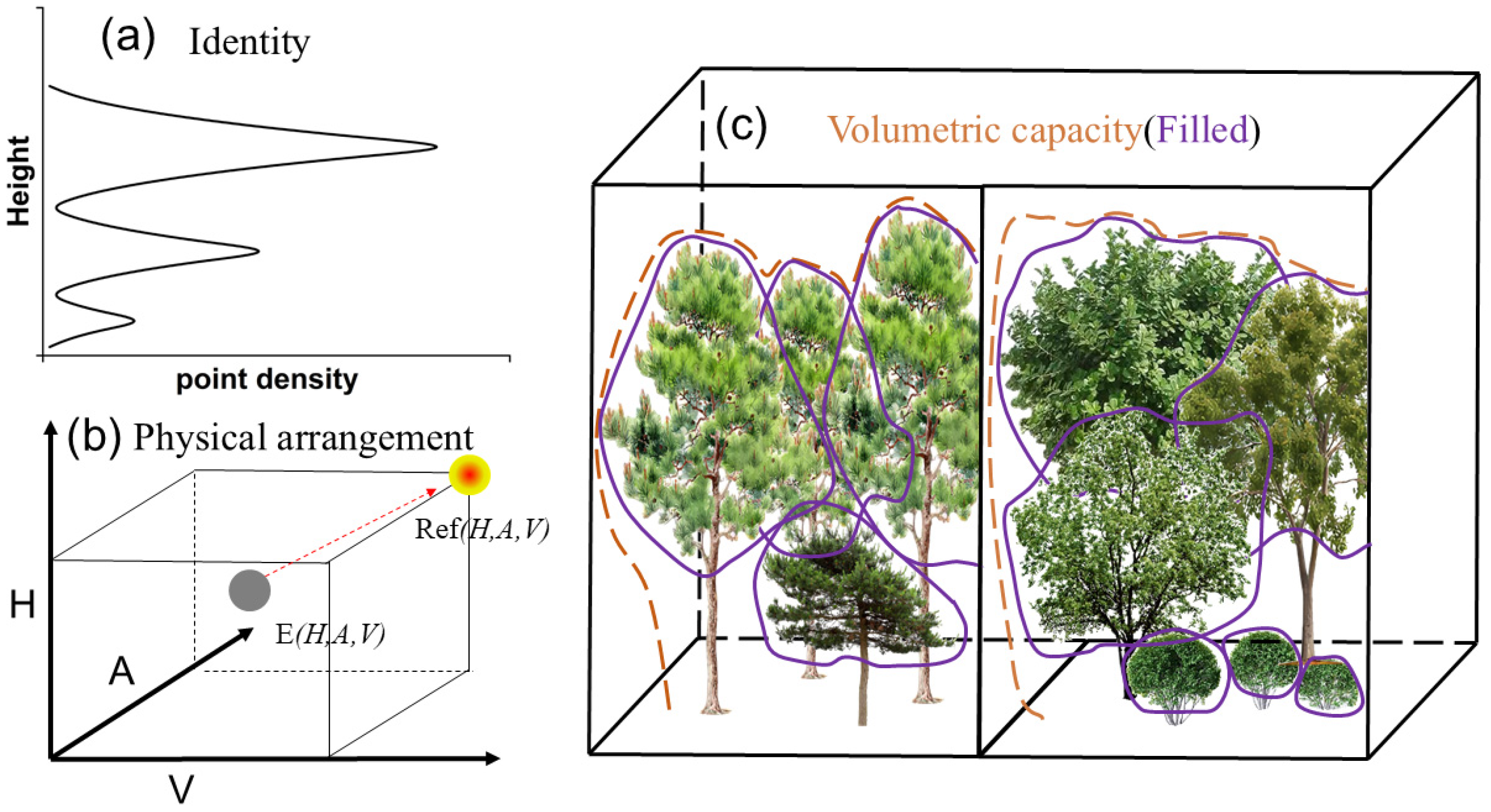
2.4. Measuring Forest Structural Diversity

Structural diversity is quantified by the space occupation of the forests on the ground and the diversity of the structural traits of individual trees at the vertical and horizontal dimensions. The point cloud data obtained from UAV-LS were utilized to extract the structural traits of forests (Figure 2). The space occupation of the forest is defined as the volumetric capacity filled by the forest components between the top of the forest canopy and the ground [28,29]. It consists of two components: (1) the spatial extent determined by the top boundary of the forest canopy and the ground; and (2) the distribution of leaves and non-photosynthetic tissues within this space. The filling of the canopy space serves as a better indicator for reflecting forest productivity and other functions [30]. Consequently, the space occupied by the forest is defined as the space filled by the forest organs above the ground, with the upper boundary being the top surface of the canopy and the lower boundary being the ground. The UAV-LS point cloud data were classified into ground points and non-ground points. Then the vegetation points were extracted from the non-ground points to generate the canopy height model (CHM), which was used to characterize the volumetric capacity of the forest canopy. The canopy height distribution (CHD) (Equation (1)) derived from point cloud data describes the distribution of the vertical point cloud density of the forest canopy [31,32,33]. It was used to compare the vertical profiles among the three forest types with different management strategies. In the horizontal dimension, a grid cell of 1 m × 1 m was created to analyze the canopy profile structure shown in Figure 2a. In the vertical dimension, the “Filter by Elevation” tool was used to create height classes at 0.5 m intervals for each forest type. The total number of points in each height class was determined and stored. The number of points in each height class was divided by the grid area to obtain the point density (points per m−2) of each height. The canopy profile structure is illustrated in Figure 2a.
C H D h = n h A h     ,
where h represents the height layer of the point clouds, n ( h ) represents the number of point clouds (points) at the h height layer in a grid, A ( h ) represents the grid area (m2), and C H D ( h ) represents the point cloud density of the grid at the h height layer (points m−2).
Based on the canopy height distribution (CHD), the skewness (α) [34] represents the direction and degree of asymmetry of the tree point cloud density. It was computed to represent the vertical distribution pattern of the point clouds. The obtained skewness values were normalized to the range of 0–1 for comparative analysis. A value of α equal to 0.5 indicates a normal distribution of the point clouds, suggesting that the forest canopy is symmetrically distributed. When α is less than 0.5, it indicates that the forest canopy is generally skewed toward the ground. When α is greater than 0.5, it indicates that the forest canopy is generally skewed toward the top of canopy.
α = i = 1 n Z i Z ¯ n 1 σ 3 ,
where α is an indicator to measure the vertical asymmetric distribution of the point clouds, Z i is the height of the i -th point in each grid cell, Z ¯ is the average height of all points in each grid cell, n is the total number of points in each grid cell, and σ is the standard deviation of the height of point cloud in a grid cell.
The diversity of the structural traits of individual trees at the vertical and horizontal dimensions was quantified by adopting the Shannon diversity index (SDI). SDI is widely used in ecological studies to quantify diversity, traditionally applied to species composition. Recent advancements in structural ecology have extended its use to describe structural diversity by treating physical attributes (e.g., tree height, canopy volume) as analogous to species in a community [35,36]. In this study, SDI (Equation (3)) was calculated for tree height, canopy area, and canopy volume in each grid cell to quantify the variability and evenness of these structural attributes across the forest stands. Structural diversity reflects the abundance of different horizontal or vertical size categories of forest traits, and was quantified following Equation (3).
S D I = i = 1 S p i ln p i ,
where p i is the proportion of a forest structural attribute belonging to the i -th category to the total number, and S is the count of categories.
The point clouds were segmented into individual trees to calculate the canopy volume of individual trees. Then, the canopy volume diversity (CVD) at the grid cell level was quantified using Equation (3) by employing the individual tree volume size to calculate p i . The range of canopy volume of individual trees was divided into 10 intervals evenly. Grid cells with a resolution of 30 m × 30 m were established to map the structural diversity metrics. The use of 30 m × 30 m grid cells for structural diversity analysis was critical to maintain consistency with prior research conducted at the Qianyanzhou station [26,27]. This scale not only aligns with stand-level management practices but also enables effective vertical monitoring of structural changes resulting from restoration strategies. Following a similar approach, the canopy projected area diversity (CAD) was measured based on the canopy projected area of individual trees (CPA), and the tree height diversity (THD) was calculated by using the proportion of individual tree height to all tree heights as a parameter. Theoretically, the maximum SDI ( S D I m a x ) for a perfectly even distribution is approximately 2.3 (using the natural logarithm as the base). For skewed distributions, S D I typically ranges between 0.5 and 2.0, depending on the forest types.

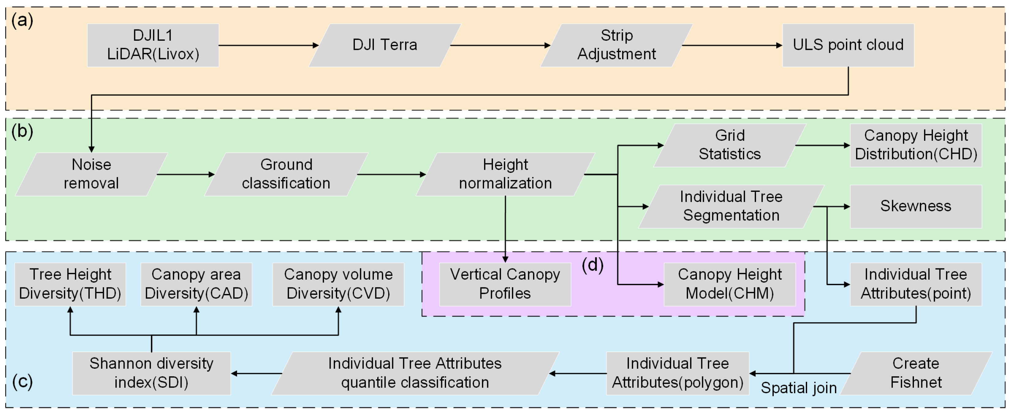
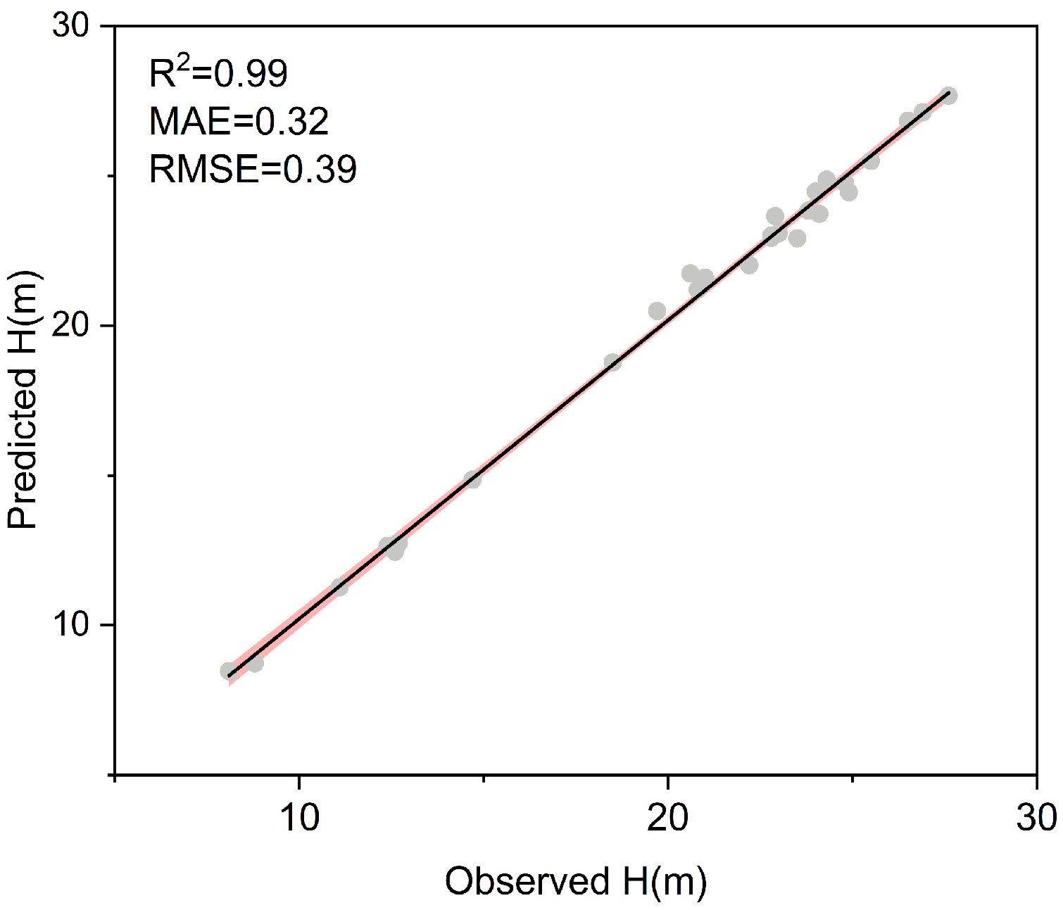
2.5. Data Processing

This study classified the forests within the study area into four parts based on forest management strategies, namely CNBF, CNCF, CPM1, and CPM2 (Figure 1). The structural diversity was calculated following the procedure given in Figure 3. The point clouds were generated from the raw UAV laser scanning (ULS) data by using DJI Terra (DJI, Shenzhen, China). The ULS point clouds were denoised following the Statistical Outlier Removal algorithm (SOR) [37] by using LiDAR360 v7.2 (Green Valley, Beijing, China). Then, the ground points were separated from other objects (vegetation, buildings, etc.) using the Improved Progressive TIN Densification algorithm [38]. The digital elevation model (DEM) with a resolution of 0.5 m was generated based on the ground points by using irregular triangulation interpolation. The ULS point cloud data were normalized according to the ground points and reclassified using LiDAR360 to obtain vegetation point clouds. Then, the region growing segmentation algorithm [39] was used to identify and segment individual trees. Finally, the attributes of individual trees including location, tree height, canopy projected area, and canopy volume were obtained. The vegetation point cloud density was calculated using LiDAR360 v7.2. Global Mapper 25 (Blue Marble Geographics, Hallowell, ME, USA) was used to generate 3-D surface models and point cloud vertical profiles for each forest type. ArcMap 10.5 (ESRI Inc., Redlands, CA, USA) was used to map tree height diversity, canopy area diversity, and canopy volume diversity.
Statistical analysis was performed using Origin2023 (OriginLab, Northampton, MA, USA). A linear regression model was used to assess the accuracy of the tree heights obtained from single-tree segmentation based on field-observed tree heights. The R2, root mean square error (RMSE), and mean absolute error (MAE) were calculated following Equations (4) and (5), respectively.
R M S E = ( y i y ^ i ) 2 n
M A E = y i y ^ i n
where n represents the total number of observations, y i is the tree height obtained from field observations, and y ^ i is the tree height obtained through the single-tree segmentation method.

3. Results

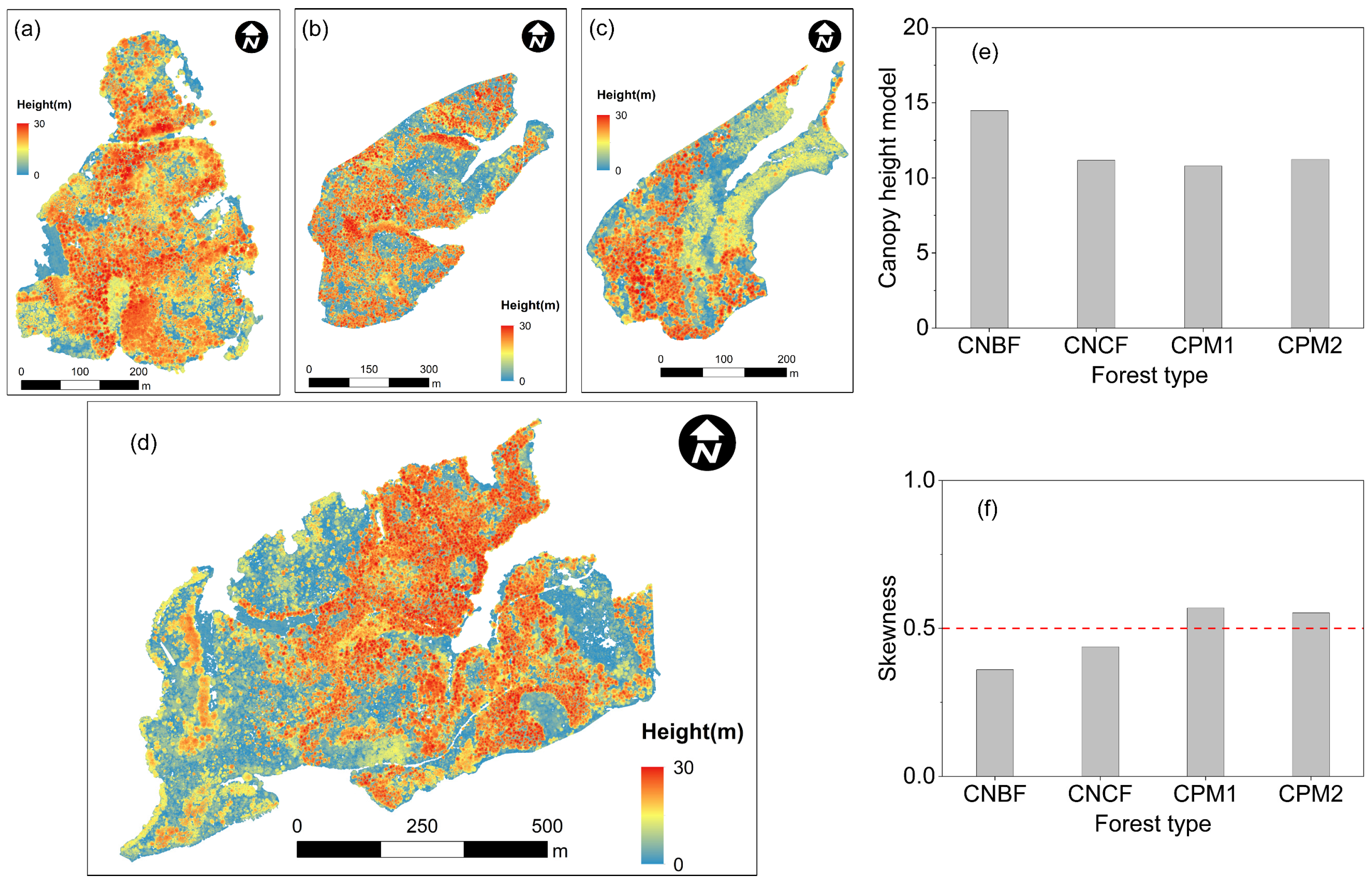
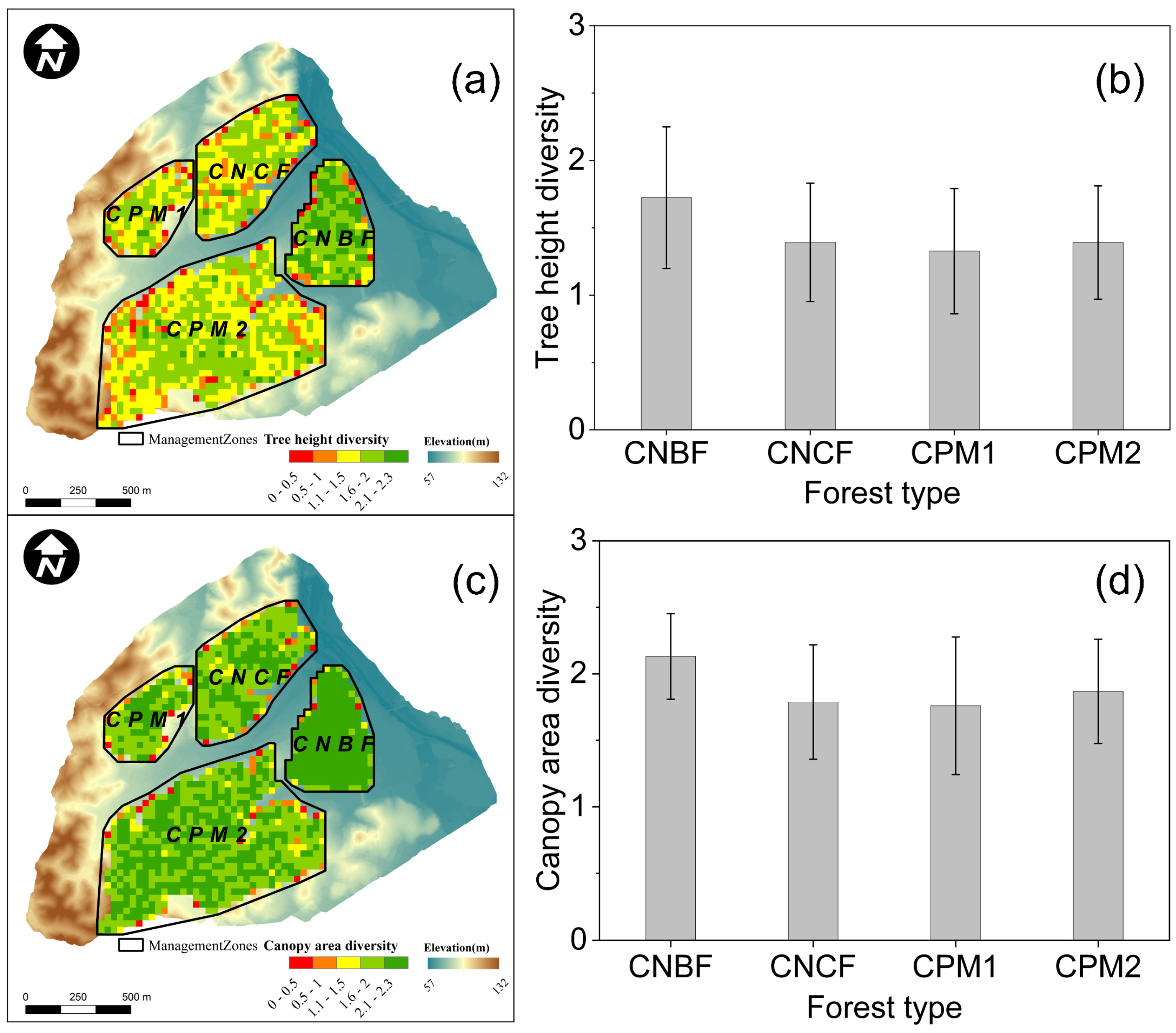
3.1. Forest Volumetric Occupation

The space occupation of the canopy in close-to-nature broadleaf forests (CNBF) is the largest among the three forest types (Figure 4). The normalized canopy skewness for CNBF and CNCF were 0.36 and 0.44, respectively. In contrast, the value of canopy skewness CPM1 and CPM2 was 0.57 and 0.55, respectively. The volumetric capacity of close-to-nature coniferous forests (CNCF) was lower than that of CNBF, although it exhibited a relatively high value for mature coniferous plantations (Figure 4e).
The canopy height distribution (CHD) revealed that the canopy profiles of broadleaf forests and coniferous forests were unimodal. However, the canopy profile of coniferous forests was skewed (Figure 5). The height of the maximum point cloud density ( C H D m a x ) in the vertical profiles of broadleaf forests was higher than that of coniferous forests. Specifically, the average C H D m a x of CNBF was approximately 17 m, whereas it occurred at around 13 m for CNCF, and around 18 m for CPM (Figure 5).

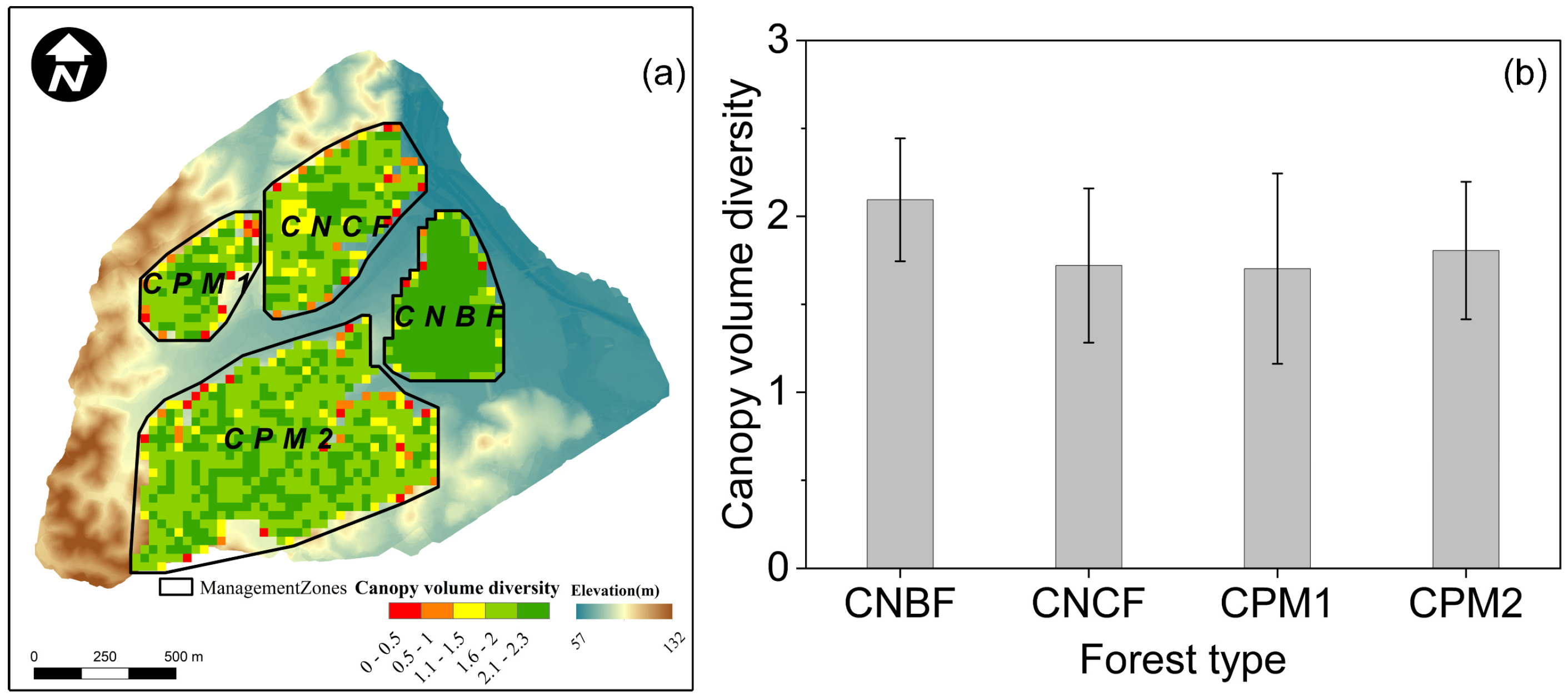
3.2. Forest Structural Diversity

The canopy volume diversity in close-to-nature forests was found to be superior compared to traditional coniferous plantations (CPM). Furthermore, CNBF exhibited greater canopy volume diversity than coniferous forests (CNCF) (Figure 6). Among the three forest types, CNBF exhibited the greatest volume diversity, with a mean value (±standard deviation) of 2.09 ± 0.35. The volume diversity of the two mature coniferous plantations (CPM) was 1.70 ± 0.54 and 1.81 ± 0.39, respectively, which was close to that of CNCF (1.72 ± 0.44).
The results of the linear regression demonstrated a high level of consistency between tree heights measured via unmanned aerial vehicle (UAV) LiDAR scanning (UAV-LS) and ground truth measurements (R2 = 0.99, MAE = 0.32 m, RMSE = 0.39 m) (Figure 7). This underscores the reliability of the tree parameters derived from the single-tree segmentation method when compared to the ground measurements.
As illustrated in Figure 8, the tree height diversity (THD) of the close-to-nature broadleaf forest (CNBF) and close-to-nature coniferous forest (CNCF) was 1.72 ± 0.53 and 1.39 ± 0.44, respectively. The THD of the two mature coniferous plantations (CPM) was slightly lower than that of the CNCF, recording 1.32 ± 0.47 and 1.39 ± 0.42, respectively. The CNBF exhibited the highest canopy projected area diversity (CAD), at 2.13 ± 0.32 (Figure 8d). For the CNCF and the two mature coniferous forests, CAD was 1.78 ± 0.43, 1.76 ± 0.52 and 1.88 ± 0.39, respectively.

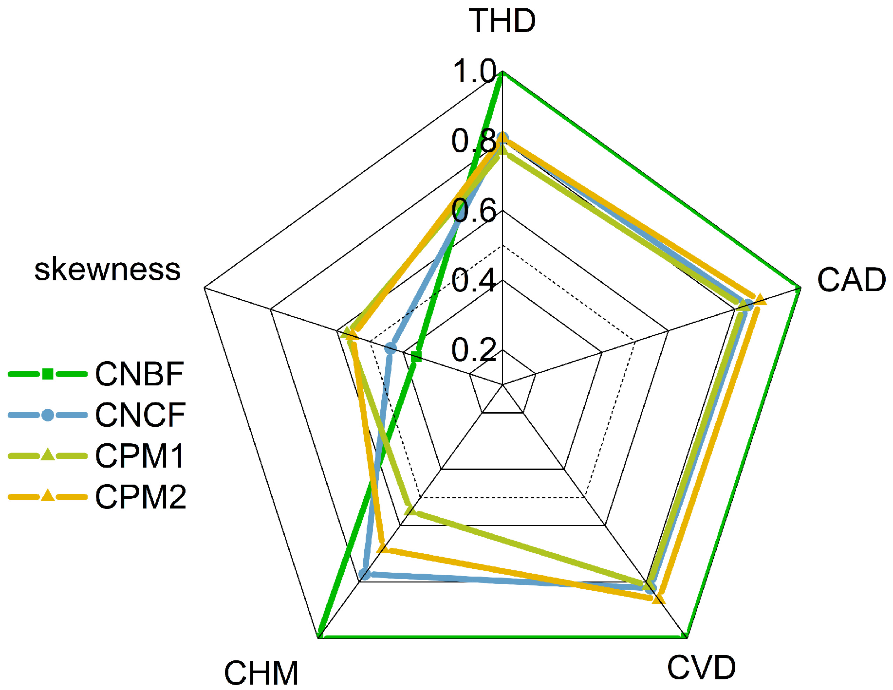
3.3. Synthesis Differences Among Forests

To facilitate comparison among forests, the diversity of tree height, canopy projected area, canopy volume, and canopy height of forests under various forest management strategies was normalized using the average values of close-to-nature broadleaf forests (CNBF) as a benchmark. The skewness was also employed to characterize the canopy inclination towards either the canopy top or the ground (Figure 9). Generally, the structural diversity of CNBF was the highest, followed by that of close-to-nature coniferous forests (CNCF) and mature coniferous plantations (CPM). Both CNBF and CNCF had skewness values below 0.5, indicating that their canopies are inclined towards the ground. In contrast, CPM demonstrated a skew greater than 0.5, suggesting that its canopy skews towards the crown top and has fewer organs close to the ground. In summary, forests managed with close-to-nature strategies exhibit higher structural diversity, canopy space occupancy, and improved space filling. Among them, CNBF, dominated by native species, exhibited the highest structural diversity and space occupancy, along with superior understory space utilization.

4. Discussion

4.1. Effectiveness of Structural Diversity

Incorporating the Shannon diversity index (SDI) with forest structural traits to quantify structural diversity is consistent with recent ecological frameworks that treat physical heterogeneity as species diversity [10]. Forest structural traits, encompassing variations in tree height, stand density, clumping patterns, canopy cover, and vertical arrangement [40], serve as effective indicators of both forest species diversity and ecological functions [5,7]. Notably, structural diversity exhibits a stronger association with ecosystem function compared to species diversity [41,42]. Vegetation structural traits such as aboveground biomass, tree height, and leaf area index are employed to characterize structural diversity and assist in elucidating ecosystem productivity, water use strategies, and carbon use efficiency [43,44,45]. Consequently, it is frequently utilized as a metric for assessing these functions [7,28,36]. Theoretical research on biodiversity-ecosystem function relationships indicates that communities with complex structures may offer more ecological niches and diverse resource utilization strategies, thereby increasing species diversity [46,47,48]. By measuring the evenness and richness of forest structural attributes, SDI effectively captures differences in the ecological niche of canopy space occupation, which is vital for linking structural diversity to ecosystem multifunctionality [5]. Moreover, structural diversity can reflect variations in species size and niche space [36]. Therefore, forest structural diversity serves as an indicator to infer forest biodiversity and the effectiveness of various management strategies [49].
The findings of this study demonstrated that structural diversity can effectively distinguish the outcomes of forest management strategies. The forest structural diversity under different management strategies was quantified by combining volumetric capacity, canopy volume diversity, tree height diversity, and canopy projected area diversity. It was confirmed that the quantification of forest structural diversity can effectively reflect the rationality of forest management strategies. Previous studies in the region of this study have indicated that broadleaf forests facilitate natural regeneration of forest species, the formation of the optimal forest stand combination, and a more reasonable vertical structure through practices such as thinning and nurturing [50,51]. The CNBF exhibited a mixture of broadleaf trees and understory shrubs. In contrast, close-to-nature coniferous forests (CNCF) display an upper layer dominated by coniferous trees interspersed with understory broadleaf shrubs [50]. Results of this study show that the canopy of CNBF has the largest space occupation compared to other forest types (Figure 5). The canopy skewness, which characterizes the distribution of canopy height of CNBF (0.36) and CNCF (0.44), was lower compared with CPM1 (0.57) and CPM2 (0.55), indicating that CNBF and CNCF have more even canopy distributions with more complex vertical structures (Figure 5). The canopy height distribution (CHD) of CNBF and CNCF displayed unimodal canopy profiles, while CPM exhibited a skewed distribution, suggesting a less even canopy structure. Specifically, the height for the occurrence of C H D m a x in CNBF (17 m) was significantly higher than that of CNCF (13 m), and was comparable to that of CPM (18 m) (Figure 5). This pattern indicates that CNBF has appropriate spatial filling at different height layers. Our results regarding the canopy height distribution (CHD) and maximum point cloud density ( C H D m a x ) are consistent with some of the findings in the prior research, though there are notable differences based on forest type and species [33]. Within the same region, broadleaf forests exhibit a higher maximum point cloud density ( C H D m a x ) compared to coniferous forests, and their canopy distribution is more homogeneous. In contrast, coniferous trees display more pronounced canopy skewness. As shown in Figure 9, the CNBF not only illustrated the largest space occupation, but also demonstrated superior space filling (Figure 5a), indicating a higher overall biomass [30]. In contrast, mature coniferous plantations (CPM) are primarily composed of species such as Pinus elliottii, Pinus massoniana, and Cunninghamia lanceolata. As the stand age increases and self-pruning occurs [52,53], branches in the lower crown will gradually shed over time. This results in elevated positions for the occurrence of point cloud density peaks and exhibits a skewed distribution towards the canopy top (Figure 5c). The skewness of point cloud density distribution reveals that the CPM achieves greater tree heights compared to CNCF but does not have as much understory vegetation. The CHD of coniferous plantations in CPM2 exhibits a similar pattern to those of CNBF (Figure 4a,d) because of the presence of both mature and young forests.

4.2. Implications for Future Forest Management

Structural diversity metrics reveal the need to optimize forest management strategies to improve vertical structure and promote understory vegetation. This study shows that the structural diversity of CNBF was the highest among the three forest types, with the structural diversity of CNCF being slightly higher than that of CPM1 but lower than that of CPM2 (Figure 9). The CVD of CNBF, at 2.09 ± 0.35, was significantly higher than that of CNCF (1.72 ± 0.44) and CPM (1.70 ± 0.54 and 1.81 ± 0.39) (Figure 6). Similarly, CNBF had the highest THD (1.72 ± 0.53) and CAD (2.13 ± 0.32), surpassing CNCF and CPM (Figure 8). This could be attributed to the incomplete maturation of understory vegetation and its inability to achieve optimal stand composition. The inclusion of mature forests and some young forests in CPM2 affects the overall structural diversity. These results suggest that the complementary relationship between coniferous and broadleaf tree species under close-to-nature management strategies can gradually alter the canopy structure of coniferous plantations, and thereby improve forest structural diversity. While the tree volume diversity and canopy projected area diversity of the mature coniferous plantations under traditional management (CPM1 and CPM2) were similar to those of CNCF, they were significantly lower than those of CNBF. Therefore, it remains necessary to optimize the vertical structure and promote understory vegetation in the future, by nurturing the diverse indigenous species that occupy different ecological niches at the vertical dimension.

5. Conclusions

This study integrates the framework of the Shannon diversity index (SDI) and forest structural traits obtained from point cloud data obtained via unmanned aerial vehicle (UAV) laser scanning to investigate the structural diversity of forests in a subtropical region under three management strategies in the Xiangxi River watershed in Taihe County, Jiangxi Province, China. The results showed that close-to-nature broadleaf forests (CNBF) exhibit the greatest structural diversity, as evidenced by superior canopy volume diversity (CVD = 2.09 ± 0.35), tree height diversity (THD = 1.72 ± 0.53), and canopy area diversity (CAD = 2.13 ± 0.32). Conversely, the coniferous mature plantations (CPM), despite having greater tree heights, exhibited lower structural diversity. The CVD (1.81 ± 0.39) of close-to-nature coniferous forests (CNCF) was comparable to that of CPM. However, it was still lower than the CVD of CNBF. These results suggest that incorporating a mix of coniferous and broadleaf species in close-to-nature management could enhance canopy structure and increase overall forest structural diversity. To further improve forest quality, future efforts could focus on augmenting the vertical structure within coniferous plantations by nursing understory vegetation. This research reaffirms the utility of forest structure diversity as an effective tool for evaluating diverse forest management practices.

Author Contributions

Conceptualization, Y.L.; methodology, Y.L. and X.H.; formal analysis, X.H.; investigation, X.H. and Y.L.; data curation, X.H.; writing—original draft preparation, X.H.; writing—review and editing, Y.L.; visualization, X.H.; supervision, Y.L.; funding acquisition, Y.L. All authors have read and agreed to the published version of the manuscript.

Funding

This work was supported by the National Key Research and Development Program of China (NO. 2022YFB3903304) and the Scientific Major Project of Water Conservancy of Jiangxi Province (Grant NO.: 202124ZDKT24).

Data Availability Statement

The data presented in this study are available on request.

Acknowledgments

We give our thanks to the Qianyanzhou Ecological Research Station of the Chinese Ecological Research Network (CERN) for supporting the field investigation.

Conflicts of Interest

The authors declare no conflicts of interest.

References

  1. Storch, F.; Dormann, C.F.; Bauhus, J. Quantifying forest structural diversity based on large-scale inventory data: A new approach to support biodiversity monitoring. For. Ecosyst. 2018, 5, 34. [Google Scholar] [CrossRef]
  2. Gao, T.; Hedblom, M.; Emilsson, T.; Nielsen, A.B. The role of forest stand structure as biodiversity indicator. For. Ecol Manag 2014, 330, 82–93. [Google Scholar] [CrossRef]
  3. Storch, F.; Boch, S.; Gossner, M.M.; Feldhaar, H.; Ammer, C.; Schall, P.; Polle, A.; Kroiher, F.; Müller, J.; Bauhus, J. Linking structure and species richness to support forest biodiversity monitoring at large scales. Ann. Sci 2023, 80, 3. [Google Scholar] [CrossRef]
  4. de Conto, T.; Armston, J.; Dubayah, R. Characterizing the structural complexity of the Earth’s forests with spaceborne lidar. Nat. Commun. 2024, 15, 8116. [Google Scholar] [CrossRef]
  5. Lang, A.K.; LaRue, E.A.; Kivlin, S.N.; Edwards, J.D.; Phillips, R.P.; Gallion, J.; Kong, N.; Parker, J.D.; McCormick, M.K.; Domke, G.; et al. Forest structural diversity is linked to soil microbial diversity. Ecosphere 2023, 14, e4702. [Google Scholar] [CrossRef]
  6. Godlee, J.L.; Ryan, C.M.; Bauman, D.; Bowers, S.J.; Carreiras, J.M.B.; Chisingui, A.V.; Cromsigt, J.P.G.M.; Druce, D.J.; Finckh, M.; Gonçalves, F.M.; et al. Structural diversity and tree density drives variation in the biodiversity–ecosystem function relationship of woodlands and savannas. New Phytol. 2021, 232, 579–594. [Google Scholar] [CrossRef]
  7. LaRue, E.A.; Hardiman, B.S.; Elliott, J.M.; Fei, S. Structural diversity as a predictor of ecosystem function. Environ. Res. Lett. 2019, 14, 114011. [Google Scholar] [CrossRef]
  8. Atkins, J.W.; Bhatt, P.; Carrasco, L.; Francis, E.; Garabedian, J.E.; Hakkenberg, C.R.; Hardiman, B.S.; Jung, J.; Koirala, A.; LaRue, E.A.; et al. Integrating forest structural diversity measurement into ecological research. Ecosphere 2023, 14, e4633. [Google Scholar] [CrossRef]
  9. Zhai, L.; Will, R.E.; Zhang, B. Structural diversity is better associated with forest productivity than species or functional diversity. Ecology 2024, 105, e4269. [Google Scholar] [CrossRef]
  10. LaRue, E.A.; Fahey, R.T.; Alveshere, B.C.; Atkins, J.W.; Bhatt, P.; Buma, B.; Chen, A.; Cousins, S.; Elliott, J.M.; Elmore, A.J.; et al. A theoretical framework for the ecological role of three-dimensional structural diversity. Front. Ecol. Environ. 2023, 21, 4–13. [Google Scholar] [CrossRef]
  11. Sullivan, T.P.; Sullivan, D.S.; Lindgren, P.M.F. Stand structure and small mammals in young lodgepole pine forest: 10-year results after thinning. Ecol. Appl. 2001, 11, 1151–1173. [Google Scholar] [CrossRef]
  12. Tyrrell, L.E.; Crow, T.R. Structural characteristics of old-growth hemlock-hardwood forests in relation to age. Ecology 1994, 75, 370–386. [Google Scholar] [CrossRef]
  13. Fei, S.; LaRue, E.A.; Hardiman, B.S.; Dahlin, K.M. Structural diversity: A digital revolution. Front. Ecol. Environ. 2023, 21, 3. [Google Scholar] [CrossRef]
  14. Hovi, A.; Korhonen, L.; Vauhkonen, J.; Korpela, I. LiDAR waveform features for tree species classification and their sensitivity to tree- and acquisition related parameters. Remote Sens. Environ. 2016, 173, 224–237. [Google Scholar] [CrossRef]
  15. Li, Y.; Guo, Q.; Wan, B.; Qin, H.; Wang, D.; Xu, K.; Song, S.; Sun, Q.; Zhao, X.; Yang, M.; et al. Current status and prospect of three-dimensional dynamic monitoring of natural resources based on LiDAR. Natl. Remote Sens. Bull. 2021, 25, 381–402. [Google Scholar] [CrossRef]
  16. Du, L.; Pang, Y.; Wang, Q.; Huang, C.; Bai, Y.; Chen, D.; Lu, W.; Kong, D. A LiDAR biomass index-based approach for tree- and plot-level biomass mapping over forest farms using 3D point clouds. Remote Sens. Environ. 2023, 290, 113543. [Google Scholar] [CrossRef]
  17. Fahey, R.T.; Atkins, J.W.; Gough, C.M.; Hardiman, B.S.; Nave, L.E.; Tallant, J.M.; Nadehoffer, K.J.; Vogel, C.; Scheuermann, C.M.; Stuart-Haëntjens, E.; et al. Defining a spectrum of integrative trait-based vegetation canopy structural types. Ecol. Lett. 2019, 22, 2049–2059. [Google Scholar] [CrossRef]
  18. Liu, S.; Yang, Y.; Wang, H. Development strategy and management countermeasures of planted forests in China: Transforming from timber-centered single objective management towards multi-purpose management for enhancing quality and benefits of ecosystem services. Acta Ecol. Sin. 2018, 38, 1–10. [Google Scholar]
  19. Lu, Y.; Luan, S.; Zhang, S.; der, H.B.v.; Lei, X.; Bao, Y. From normal forest to close-to-nature forest: Multi-functional forestry and its practice at national, regional and forest management unit levels in Germany. World For. Res. 2010, 23, 1–11. [Google Scholar]
  20. Li, T.; Lu, Y.; Jiang, J. Assessment of forest management model of pinus massoniana plantation. J. Northwest For. Univ. 2015, 30, 164–171. [Google Scholar]
  21. Franklin, J.F. Ecological Science: A Conceptual Basis for FEMAT. J. For. 1994, 92, 21–23. [Google Scholar] [CrossRef]
  22. Larsen, J.B.; Angelstam, P.; Bauhus, J.; Carvalho, J.F.; Diaci, J.; Dobrowolska, D.; Gazda, A.; Gustafsson, L.; Krumm, F.; Knoke, T.; et al. Closer-to-Nature Forest Management: From Science to Policy 12; European Forest Institute: Joensuu, Finland, 2022. [Google Scholar] [CrossRef]
  23. Schütz, J.-P.; Saniga, M.; Diaci, J.; Vrška, T. Comparing close-to-naturesilviculture with processes in pristine forests: Lessons from Central Europe. Ann. Sci. 2016, 73, 911–921. [Google Scholar] [CrossRef]
  24. Li, S.; Yu, G.; Yu, X.; He, H.; Guo, X. A Brief Introduction to Chinese Ecosystem Research Network (CERN). J. Resour. Ecol. 2015, 6, 192–196. [Google Scholar]
  25. Hao, Z.; Gao, Y.; Zhang, J.Z.; Xu, Y.J.; Yu, G.R. Characteristics of atmospheric nitrogen wet deposition and associated impact on n transport in the watershed of red soil area in southern China. Environ. Sci. 2015, 36, 1630–1638. [Google Scholar] [CrossRef]
  26. Jiang, P.; Wang, H.; Fu, X.; Dai, X.; Kou, L.; Wang, J. Elaborate differences between trees and understory plants in the deployment of fine roots. Plant Soil 2018, 431, 433–447. [Google Scholar] [CrossRef]
  27. Hu, Q.; Hu, L.; Li, X. Plant diversity in qianyanzhou after 20 years of small watershed treatment. Acta Phytoecol. Sin. 2005, 29, 766–774. [Google Scholar]
  28. Listopad, C.M.C.S.; Masters, R.E.; Drake, J.; Weishampel, J.; Branquinho, C. Structural diversity indices based on airborne LiDAR as ecological indicators for managing highly dynamic landscapes. Ecol. Indic. 2015, 57, 268–279. [Google Scholar] [CrossRef]
  29. Walz, U. Indicators to monitor the structural diversity of landscapes. Ecol. Model. 2015, 295, 88–106. [Google Scholar] [CrossRef]
  30. Juchheim, J.; Ammer, C.; Schall, P.; Seidel, D. Canopy space filling rather than conventional measures of structural diversity explains productivity of beech stands. For. Ecol. Manag. 2017, 395, 19–26. [Google Scholar] [CrossRef]
  31. Zhao, K.; Popescu, S.; Nelson, R. Lidar remote sensing of forest biomass: A scale-invariant estimation approach using airborne lasers. Remote Sens. Environ. 2009, 113, 182–196. [Google Scholar] [CrossRef]
  32. Weishampel, J.F.; Drake, J.B.; Cooper, A.; Blair, J.B.; Hofton, M. Forest canopy recovery from the 1938 hurricane and subsequent salvage damage measured with airborne LiDAR. Remote Sens. Environ. 2007, 109, 142–153. [Google Scholar] [CrossRef]
  33. Panagiotidis, D.; Abdollahnejad, A.; Slavík, M. 3D point cloud fusion from UAV and TLS to assess temperate managed forest structures. Int. J. Appl. Earth Obs. Geoinf. 2022, 112, 102917. [Google Scholar] [CrossRef]
  34. Legendre, P.; Legendre, L. Chapter 4—Multidimensional quantitative data. In Developments in Environmental Modelling; Legendre, P., Legendre, L., Eds.; Elsevier: Amsterdam, The Netherlands, 2012; Volume 24, pp. 143–194. [Google Scholar]
  35. Staudhammer, C.L.; LeMay, V.M. Introduction and evaluation of possible indices of stand structural diversity. Can. J. For. Res. 2001, 31, 1105–1115. [Google Scholar] [CrossRef]
  36. LaRue, E.A.; Knott, J.A.; Domke, G.M.; Chen, H.Y.H.; Guo, Q.; Hisano, M.; Oswalt, C.; Oswalt, S.; Kong, N.; Potter, K.M.; et al. Structural diversity as a reliable and novel predictor for ecosystem productivity. Front. Ecol. Environ. 2023, 21, 33–39. [Google Scholar] [CrossRef]
  37. Balta, H.; Velagic, J.; Bosschaerts, W.; De Cubber, G.; Siciliano, B. Fast statistical outlier removal based method for large 3D point clouds of outdoor environments. IFAC-PapersOnLine 2018, 51, 348–353. [Google Scholar] [CrossRef]
  38. Zhao, X.; Guo, Q.; Su, Y.; Xue, B. Improved progressive TIN densification filtering algorithm for airborne LiDAR data in forested areas. ISPRS J. Photogramm. Remote Sens. 2016, 117, 79–91. [Google Scholar] [CrossRef]
  39. Li, W.; Guo, Q.; Jakubowski, M.K.; Kelly, M. A new method for segmenting individual trees from the lidar point cloud. Photogramm. Eng. Remote Sens. 2012, 78, 75–84. [Google Scholar] [CrossRef]
  40. Atkins, J.W.; Bohrer, G.; Fahey, R.T.; Hardiman, B.S.; Morin, T.H.; Stovall, A.E.L.; Zimmerman, N.; Gough, C.M. Quantifying vegetation and canopy structural complexity from terrestrial LiDAR data using the FORESTR R package. Methods Ecol. Evol. 2018, 9, 2057–2066. [Google Scholar] [CrossRef]
  41. Ali, A. Forest stand structure and functioning: Current knowledge and future challenges. Ecol. Indic. 2019, 98, 665–677. [Google Scholar] [CrossRef]
  42. Dănescu, A.; Albrecht, A.T.; Bauhus, J. Structural diversity promotes productivity of mixed, uneven-aged forests in southwestern Germany. Oecologia 2016, 182, 319–333. [Google Scholar] [CrossRef]
  43. Migliavacca, M.; Musavi, T.; Mahecha, M.D.; Nelson, J.A.; Knauer, J.; Baldocchi, D.D.; Perez-Priego, O.; Christiansen, R.; Peters, J.; Anderson, K.; et al. The three major axes of terrestrial ecosystem function. Nature 2021, 598, 468–472. [Google Scholar] [CrossRef] [PubMed]
  44. Williams, L.J.; Paquette, A.; Cavender-Bares, J.; Messier, C.; Reich, P.B. Spatial complementarity in tree crowns explains overyielding in species mixtures. Nat. Ecol. Evol. 2017, 1, 63. [Google Scholar] [CrossRef] [PubMed]
  45. Forrester, D.I.; Bauhus, J. A review of processes behind diversity—productivity relationships in forests. Curr. For. Rep. 2016, 2, 45–61. [Google Scholar] [CrossRef]
  46. Bazzaz, F.A. Plant species diversity in old-field successional ecosystems in Southern Illinois. Ecology 1975, 56, 485–488. [Google Scholar] [CrossRef]
  47. Loreau, M.; Hector, A. Partitioning selection and complementarity in biodiversity experiments. Nature 2001, 412, 72–76. [Google Scholar] [CrossRef]
  48. Hooper, D.U.; Chapin Iii, F.S.; Ewel, J.J.; Hector, A.; Inchausti, P.; Lavorel, S.; Lawton, J.H.; Lodge, D.M.; Loreau, M.; Naeem, S.; et al. Effects of biodiversity on ecosystem functioning: A consensus of current knowledge. Ecol. Monogr. 2005, 75, 3–35. [Google Scholar] [CrossRef]
  49. Camarretta, N.; Harrison, P.A.; Bailey, T.; Potts, B.; Lucieer, A.; Davidson, N.; Hunt, M. Monitoring forest structure to guide adaptive management of forest restoration: A review of remote sensing approaches. New For. 2020, 51, 573–596. [Google Scholar] [CrossRef]
  50. Lu, Y.; Zhang, S.G.; Lei, X.D.; Ning, J.; Wang, Y. Theoretical basis and implementation techniques on close-to-nature transformation of plantations. World For. Res. 2009, 22, 20–27. [Google Scholar]
  51. Ma, Z.; Wang, H.; Yang, F.; Fu, X.; Fang, H.; Wang, J.; Dai, X.; Kou, X.; Kou, L.; Zhao, B. Ecological restoration and sustainable development of forest ecosystem in subtropical red soil hilly region based on long-term observation and research. Bull. Chin. Acad. Sci. 2020, 35, 1525–1536. [Google Scholar]
  52. Brunet-Navarro, P.; Sterck, F.J.; Vayreda, J.; Martinez-Vilalta, J.; Mohren, G.M.J. Self-thinning in four pine species: An evaluation of potential climate impacts. Ann. For. Sci. 2016, 73, 1025–1034. [Google Scholar] [CrossRef]
  53. Oliver, C.; Larson, B. Forest Stand Dynamics; Wiley: New York, NY, USA, 1996. [Google Scholar]
Figure 1. Location and landscape of the study area: (a) Location of the study area; (b) DEM of the watershed generated by UAV-LS; (c) Close-to-nature broadleaf forest (CNBF); (d) Close-to-nature coniferous forest (CNCF); (e) Coniferous mature plantation (CPM).
Forests 16 00723 g001
Figure 2. Schematic diagram illustrates quantification of forest structural diversity: (a) Vertical distribution types described by the canopy height distribution; (b) Spatial combination (H refers to tree height diversity, A refers to canopy projected area diversity, V refers to canopy volume diversity, and Ref refers to the reference value for structural diversity); (c) Volumetric capacity (spatial extent and filling).
Forests 16 00723 g002
Figure 3. Data processing flowchart of mapping the structural diversity: (a) pre-processing of acquired datasets from DJI L1; (b) processing of acquired point cloud datasets using LiDAR360 software applications; (c) quantification of the structural diversity indices (THD, CAD, and CVD) in ArcGIS using individual tree attributes; (d) Generation of canopy height model (CHM) and vertical canopy profiles in GlobalMapper.
Forests 16 00723 g003
Figure 4. Forest canopy height. (a) Close-to-nature broadleaf forest (CNBF); (b) Close-to-nature coniferous forest (CNCF); (c,d) Traditional coniferous plantation (CPM); (e) Average canopy height diversity index; (f) The normalized canopy skewness.
Forests 16 00723 g004
Figure 5. Point cloud distribution on canopy vertical profiles. (a) Close-to-nature broadleaf forest (CNBF); (b) Close-to-nature coniferous forest (CNCF); (c,d) Traditional coniferous plantation (CPM); (e) Point cloud profile corresponding to CNBF; (f) Point cloud profile of CNCF; (g,h) Point cloud of CPM.
Forests 16 00723 g005
Figure 6. Canopy volume diversity. (a) Canopy volume diversity distribution; (b) Average Canopy volume diversity index. CNBF—close-to-nature broadleaf forest, CPM—mature coniferous plantation, CNCF—close-to-nature coniferous forest. Error bars represent standard deviation.
Forests 16 00723 g006
Figure 7. Scatterplot of observed against predicted values for canopy height (H).
Forests 16 00723 g007
Figure 8. Forest structure diversity. (a) Tree height diversity distribution; (b) Average tree height diversity index; (c) Canopy projected area diversity; (d) Average canopy projected area diversity statistics. Error bars represent standard deviations.
Forests 16 00723 g008
Figure 9. Radar chart of normalized metrics of forest structural features. The dashed line indicates the 0.5 axis line. THD—tree height diversity, CAD—canopy projected area diversity, CVD—canopy volume diversity, CHM—canopy height derived from the canopy height model.
Forests 16 00723 g009
Disclaimer/Publisher’s Note: The statements, opinions and data contained in all publications are solely those of the individual author(s) and contributor(s) and not of MDPI and/or the editor(s). MDPI and/or the editor(s) disclaim responsibility for any injury to people or property resulting from any ideas, methods, instructions or products referred to in the content.

