Article

Geographic Factors Impacting the Demand for Public EV Charging: An Observational Study

Renewable Energy Storage Laboratory, Dalhousie University, 5217 Morris Street, 4th Floor, P.O. Box 15000, Halifax, NS B3H 4R2, Canada
*
Author to whom correspondence should be addressed.
World Electr. Veh. J. 2024, 15(10), 445; https://doi.org/10.3390/wevj15100445
Submission received: 27 August 2024 / Revised: 21 September 2024 / Accepted: 27 September 2024 / Published: 29 September 2024

Abstract

:
The practicality and substitutability of electric vehicles depend on there being a fast, reliable way to recharge on round trips beyond the range of a single charge. Grouping such infrastructure into charging hubs benefits developers and operators through economies of scale and electric vehicle drivers in terms of travel logistics and passed-through cost savings. The need for charging capacity at en-route charging hubs is impacted by the following four identifiable geo-social parameters: (a) highway travel volumes, reflecting the rate at which electric vehicles are expending energy in the area; (b) local population, reflecting both the increased needs of electric vehicle owners without dedicated home chargers and the reduced needs of those commuting into a metropolitan center; (c) the quantity of competing charging stations; and (d) being on a critical interprovincial route. Twelve charging stations located in diverse locations around Nova Scotia, Canada, were evaluated in terms of these four parameters, and their recorded use was investigated from a dataset of 26,000 charging events between April 2022 and April 2024. The regression reveals that there are strong positive correlations between demand for fast charging and (a) traffic volumes (45%) and (c) being on an interprovincial route (42%), while there is only a very weak correlation with (b) local population (2%). Interestingly, there is only a weak negative correlation with (c) the number and capacity of nearby competing chargers (−6%), suggesting that either in short-term route choice or longer-term vehicle choice, the presence of chargers encourages electric vehicles.

1. Introduction

Around the world, electric vehicles (EVs) are gaining in popularity and capturing an ever-increasing share of new vehicle sales, reaching 18% of all cars sold in 2023 [1]. This rapid rise in EV popularity, combined with supply constraints and difficult economics, has led to many regions having an undersupply of fast public charging [2]. There is significant literature offering guidance on the necessary capacity of direct current fast charging (DCFC) infrastructure and allocation of it to geographic hubs to support present and future populations of EVs. Much of that literature relies on data-intensive models of driver behavior and vehicle tracking, or extensive traffic flow data. Either of these methods may limit applications in areas where such data do not exist or limit them to ventures that can afford such study.
As an alternative to such data-intensive approaches, this research describes an investigation into geographic factors associated with DCFC hub placement that impact the demand for charging. All input variables into the analysis described here are ubiquitous, making assessment accessible and straightforward. The result is a component of a model to evaluate charging hub sizing (DCFCs per hub or power [kW] per hub) that is accessible to policymakers and infrastructure planners.
Note that the scope of this study is intentionally restricted, and the output will require application of additional assumptions, principally related to the population of EVs within a region in some future target year to which the infrastructure model is applied. This investigation evaluates the relative (and combined) impact of geographic features on the demand for charging, which is an approach not well covered in the literature.

1.1. Literature Review

There are popularly cited concerns over the inconvenience and time demands of charging EVs, more so among people who do not own an EV [3]. However, studies of American [4] and Austrian [5] EV driver behavior have found that roughly 88% of electrical energy consumed by EVs comes from home charging. An Australian study similarly found that when charging at work is also available, that figure rises to 90% [6]. Despite the convenience and utility of home or work charging, it cannot be a complete solution for EV substitutability, which must support long-distance trips to any location.
In such cases, fast, enroute charging must be available. A study in Norway, where EVs make up the vast majority of new vehicle sales [1], observed that the availability of public charging led to an increase in EV market share [7]. Similarly, a study in the western USA observed a correlation between high-power public charging and EV market share of new vehicle sales [8]. A survey of German drivers found that ubiquity of charging was less important to potential EV buyers than high charging speeds [9]. Interestingly, a survey of potential EV buyers in Canada found little consideration was given to public charging infrastructure [10], a finding that seemingly contradicts this premise.
The preferred configuration of DCFC deployment is into ‘clusters’ known as charging hubs, as reflected in the US-DOT rulemaking for sites to be eligible for federal funding [11]. Advantages of charging hubs are listed in [12] and include the following:
  • Reducing the chances of EV drivers finding all cordsets in use and having to debate whether another nearby site will have better availability
  • Reducing maximum wait times since everyone is in a common queue
  • Improving site reliability, since even if one charger is inoperable, others in the same hub will likely still work. Private network operators have a lackluster record of site maintenance [13].
  • A large charging hub, where several or many EV drivers must spend tens of minutes, may nucleate a small commercial zone, with benefits accruing to both the drivers waiting there in the form of added amenities and the local economy.
  • In the construction phase, economies of scale such as ‘soft costs’ like permitting and ‘hard costs’ such as trenching and pouring transformer pad mounts mean that charging hubs should realize lower per-cordset costs than dispersed sites [14].
  • In operation, having multiple units of a given hardware reduces the burden of training a maintenance workforce to individual models and keeping spare parts.
The spatial distribution of charging hubs is still a matter of active research and is regarded as a largely unsolved problem. A number of authors start with a target spacing between possible charging hubs, but what that distance should be is highly debated, with suggested values ranging from 200 km [6], ~175 km [15], 112 km [4], 80 km [11], 65 km [16], or 50 km [17]. Closer spacing offers greater user convenience, while longer spacing may increase the benefits of ‘charging hubs’ described above for a given regional supply of charging capacity.
Most analyses of DCFC infrastructure deployment offer relatively little guidance in relating geographic considerations to the need for charging. A nationwide study conducted in the USA differentiated deployment by ‘rural’ areas, ‘towns’, and ‘cities’ but did not elaborate on how to site hubs [4]. Other analyses constrain their analysis to a restricted geographic scope, such as along major highways in the US [18], along a busy highway in Ontario, Canada [16], or a pair of major highways in Pakistan [19], all of which place a focus on enabling long-distance travel. Locating infrastructure near large highways, as these studies assume, is generally guided by a desire to maximize the convenience of the maximum number of users traveling on major corridors [20], and other research proposes that maximizing such convenience is critical not just for long-distance travel but also for routine commuting [21]. Some analyses place emphasis on locations where user amenities are present, where EV drivers may enjoy spending time [22]. Other siting considerations include nearby traffic volumes, site security [19], and the availability of three-phase electricity [17].

1.2. Structure of This Study

In this study, the impact of observable geographic conditions on the apparent demand for DCFC is investigated. The objective of this investigation is to produce a quantitative framework by which to estimate the relative need for charging capacity at different prospective charging hub sites. To do this, we use a set of 27,700 charging events occurring over a 24-month period at 12 DCFC sites in Nova Scotia, Canada. In Section 2, the data used to characterize the 12 sites in the investigation are described, including the data source and quality control. These consist of (Section 2.2) local traffic volumes past or around the site, (Section 2.3) the local population, (Section 2.4) the degree of competition from other public fast charging infrastructure, and (Section 2.5) being on an interprovincial route. (All sites in this study are on ‘major’ highways, though some are more important to interprovincial travel than others). In Section 3, the analytical methods are described, and the results are presented. In Section 4, there is a discussion of the key results. Finally, in Section 5, conclusions are drawn from the findings, and policy implications are discussed.

1.3. Context of the Analysis

The province’s electrical utility, Nova Scotia Power Inc., operates a network of 12 DCFC hubs, shown in Figure 1. All 12 sites were installed and commissioned in the summer of 2018. Each location has a single 50 kW charger, able to deliver through either a ChaDeMo or SAE CCS cable. The network design focused on enabling long distance travel, resulting in each site being close to an exit from the province’s primary ‘100-series’ highway system. A target hub spacing of 65 km results in a relatively broad distribution, enabling access to most areas of the province even for shorter-ranged EVs [23]. As of this writing, this network accounts for about a third (33%) of the DCFC sites in operation in the province and represents the most spatially diverse network, fulfilling the utility’s mandate to serve all Nova Scotians. Note that this study is based on data from only these 12 chargers because no data sharing agreement exists with other site operators.

2. Data and Methods

This is a data-driven analysis of relationships between geographical factors and DCFC utilization. Data for this analysis come from several sources and may impact utilization through a broad range of behavioral mechanisms. The data sources for the explanatory (independent) variables and the output (dependent) variable are discussed in this section, along with speculation about the possible mechanisms that might pertain to each.

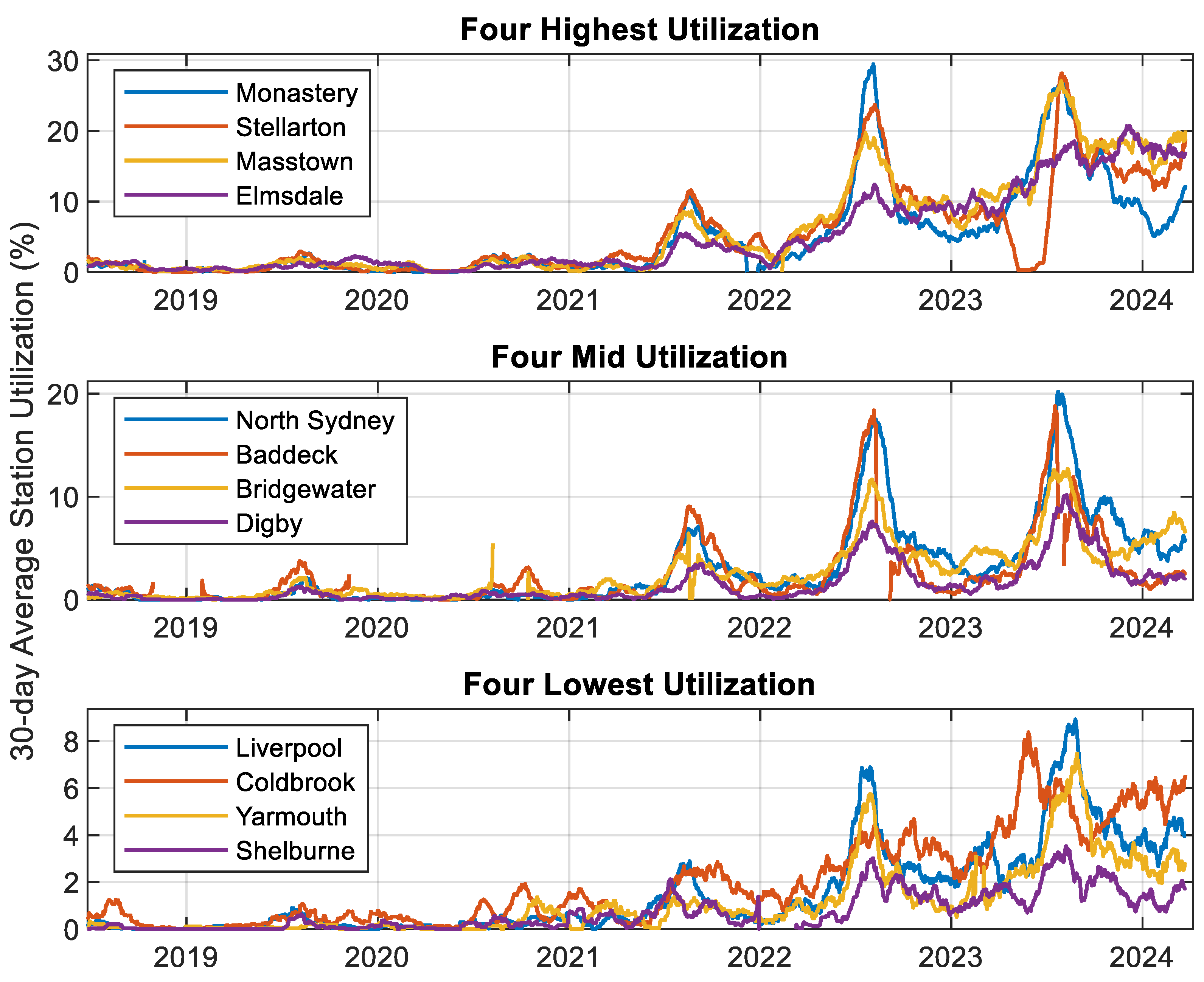
2.1. Charging Event Data

The output, or dependent variable, of this analysis is the utilization of a DCFC site, measured as the count of charging events per year. This metric is evaluated at DCFC sites based on charging event data produced by the network of DCFCs described in Section 1.3: Context of the analysis. The dataset is a record of individual charge events, comprising a start and stop time, the quantity of energy dispensed, a user identification number, the reason for the termination of the charging session (user action, vehicle action, fault, etc.), and several other parameters. These data were provided to this study by Nova Scotia Power Inc., the provincial electric utility and operator of these sites, so only sites operated by them are included. Despite automated data collection, a variety of data error types appear in the charging event record. Quality control operations on the DCFC event data mimic those described in [12] and consist of:
(1)
Identifying and deleting duplicate events.
(2)
Aggregating sequential charging events when the same user ID initiated charging at the same location multiple times separated by less than 20 min, if no other user initiated a charging event between two such events.
(3)
Deleting charging events that, after aggregation, indicated less than 0.5 kWh of energy was transferred.
The raw dataset consists of all charging events occurring in this network between the commissioning date of 23 June 2018 and the most recent available data of 6 April 2024. The raw dataset logs about 45,000 charging events. After quality control, primarily due to event aggregation, the number of unique charging events was reduced to 35,800. To visualize, initially evaluate, and provide a description of the data, each of the 12 sites was evaluated by its utilization factor (UF), a metric defined for a smoothing time window ∆t in [12] according to Equation (1) for a single DCFC cordset.
U F = C = 1 M E C P × t
where P is the nominal power of the charger (in kW, 50 kW for these sites), and EC is the energy (in kWh) supplied in charge event C, among the M charge events that take place within ∆t. The UF thus describes the load factor of the charger within ∆t.
The 30-day UF of each of the 12 chargers (i.e., ∆t = 30 days) through the 5.75 years of data are shown in Figure 2. For readability, the 12 sites are separated into three groups based on the highest observed UF value; the groupings display peak UF values between 20% and 30% (top plot), between 10% and 20% (middle plot), and below 10% (bottom plot). For contrast, [12] recommend that UF be restricted to 10% in designing a DCFC network to avoid excessive probability of queuing to charge. This suggests that by their metric, this network is under-built for the needs of EV drivers in Nova Scotia, at least at some of the sites, during some parts of the year.
Figure 2 shows a variety of important points about the charger utilization dataset. First, it shows that utilization has grown significantly through the duration of data gathering. Note that travel in 2020, and to an extent in 2021, was depressed by COVID-related travel restrictions. Second, it shows a very clear seasonal travel spike in the late summer, when schools are not in session and the weather is mostly likely to be pleasant. This implies that tourism, be it interprovincial or intraprovincial, is a very important consideration in the demand for DCFCs. Third, it shows that this seasonal spike is not consistent in relative magnitude across the various locations (tourist destinations are not evenly distributed across the province). Fourth, it shows that, irrespective of the seasonality, there is a significant difference between the UF of chargers at different sites around the province, amounting to a factor of roughly 10. Finally, Figure 2 shows various kinds of errors in the data record, such as a prolonged service interruption in Stellarton (red, top plot) during the spring of 2023 and anomalous spikes in utilization, such as in Bridgewater (yellow, middle plot) during the summer of 2020.
To avoid possible confounding effects on charging demand by the COVID pandemic, the analysis was isolated to the most recent 2-year period, 7 April 2022 through 6 April 2024. This eliminated a relatively small fraction of the ~35,800 events remaining after the first three quality control steps, leaving ~27,700.

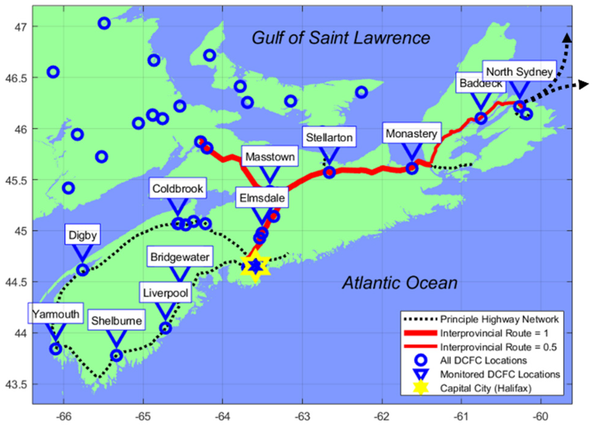
2.2. Traffic Volumes

Intuitively, the dominant driver of the demand for charging is the volume of traffic near to, or driving past, the site. Like many other jurisdictions, Nova Scotia performs regular traffic counts on all primary and secondary provincial highways. These traffic counts, described as ‘Average Daily Traffic’ (ADT), are archived and available to the public through the province’s data portal [24]. Data include highway number, highway section number, count location description (e.g., “0.5 km east of Brushy Hill Rd.”), and the date the count took place. Several traffic counts are available for each section of highway.
To quantify the likely volume of traffic that impacts the utilization of each of the 12 chargers, a ‘control volume’ was defined around each. This volume was not strictly defined by a fixed distance but by a cohort of highway sections that, as clearly as possible, represent where vehicles charging at this site could have come from or could go to. This method is functionally the same as that described in [17]. An example of this volume is shown in Figure 3.
Figure 3 shows the highways around Elmsdale, NS, and six sections of highway used to quantify its local highway traffic. Two of the highway sections evaluated are on a primary provincial highway (Highway 102), and four are on secondary highways (routes 2 and 214). The sum of traffic indicated by provincial traffic counts at the six highlighted sections is divided by 2, to reflect that each vehicle that could make use of this charging site for long-distance travel will enter the volume at one location and exit it at another.
Traffic volumes were scaled down by a factor of 1000 to ‘kADT’ for legibility.

2.3. Local Population
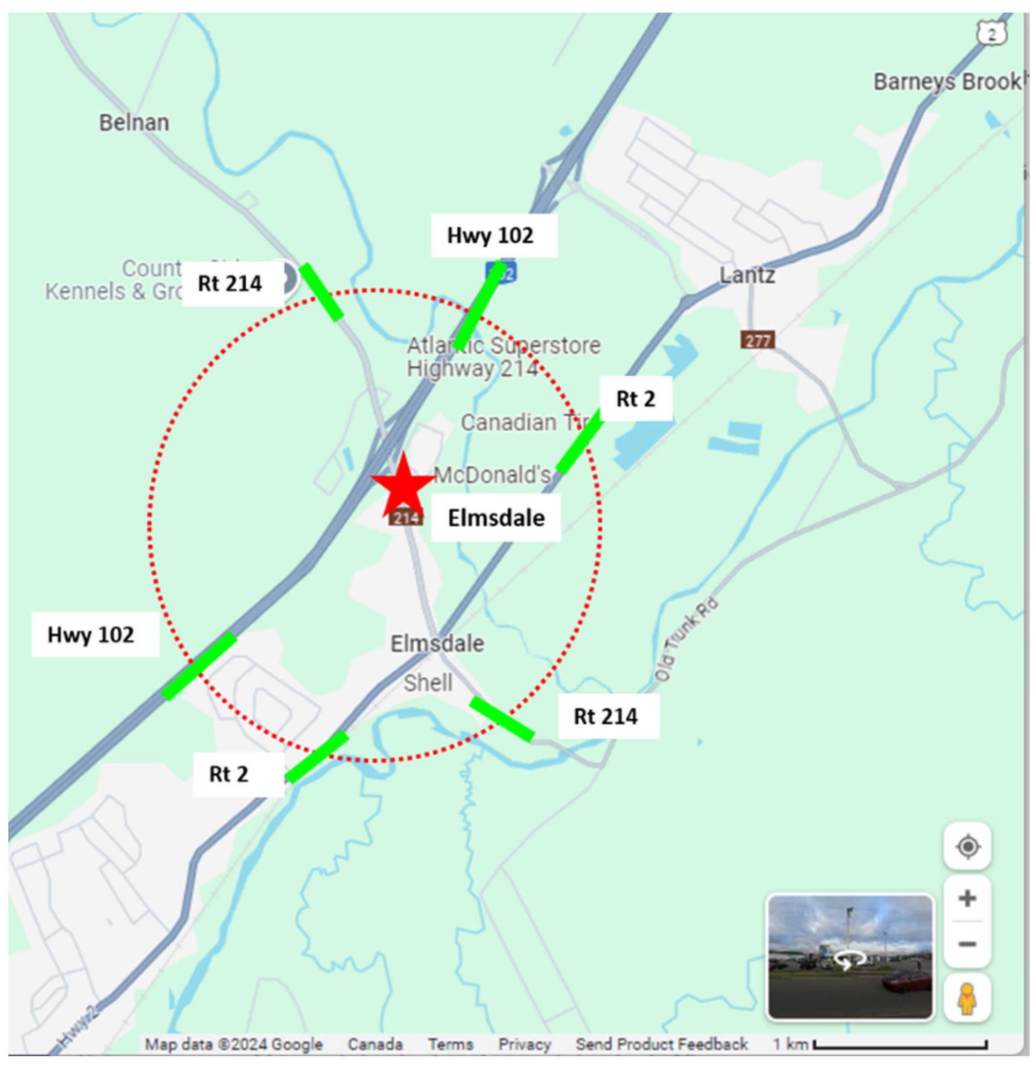
The ‘population’ metric attributed to each DCFC is intended to represent the population of the surrounding communities/neighborhoods, or that of the nearest town for more rural sites. Values for these numbers were drawn from a combination of formal and crowd-sourced online sources [26,27,28]. Where data were available on more than one of these sources, they were compared, and either the most representative ‘local’ population was used, based on differences between jurisdictional boundaries in the population counts, or the values were averaged. This representation of ‘local population’ is intended to quantify two possible conflicting mechanisms that could impact the frequency with which a DCFC site is used.
On one hand, if there is a significant population of ‘garage orphans’ (EV owners who do not have a dedicated charger at home [29]), they may rely on the DCFC for routine charging rather than just long-distance trips, as may be the most common use case. Using the finding that 88% of EV energy comes from home chargers [4,5], a garage orphan would increase the demand on their local DCFC by a factor of 8.3 (100%/12%).
On the other hand, if the local population metric reflects a metropolitan area that attracts a significant number of commuters, then the demand for charging at that DCFC could be negatively impacted relative to other locations with similar traffic volume. This mechanism is based on the premise that car buyers are unlikely to select an EV that is unable to complete a round-trip commute without fast charging, i.e., a population center that draws a lot of commuters will increase traffic volumes without increasing demand for charging.
Local population values were scaled down by a factor of 1000 for legibility.

2.4. Competition

As stated in Section 1.3, the charging network providing data for this study represents about a third of the total population of DCFCs in the province. While much of the monitored network may be described as ‘remote’ from any other public fast charging infrastructure, four of the sites are not. Intuitively, the presence of other DCFCs in the vicinity should reduce the utilization of both, since they will presumably split the total demand for DCFC at that location. To quantify DCFC competition, an equation was constructed to reflect the relative attractiveness of other nearby sites. “Nearby” is defined as being within 25-min driving distance, as determined by Google Maps directions [25].
C o m p = n = 1 N P k W _ n × 25 D i s t M i n u t e s _ n 2 × P l u g F a c t o r n P k W _ h e r e × 25 0 2 × 1
In Equation (2), the numerator constructs a sum across N competing sites within a 25-minute driving radius. Each competing site has a site power PkW_n, which is the product of the power per DCFC cordset and the number of cordsets. Each competing site is located a distance DistMintes_n away, evaluated in driving time on Google Maps directions [25]. Note that sites outside this 25-minute driving distance were not considered to be ‘competition’, so the distance term in the numerator is never negative. The attractiveness of competing sites was inferred to drop off with the square of the distance. The factor PlugFactorn is used to differentiate DCFC sites using Tesla’s then-proprietary connector [30], meaning that only Tesla vehicles, constituting 37% of the EVs registered in Nova Scotia [31], could use that site. I.e., if competing DCFC n offers only Tesla hardware, PlugFactorn is set to 0.37 to reflect the fraction of the EV fleet that it can serve. This calculation will become more complicated as North American EVs from other manufacturers transition to Tesla’s plug.
The sum of the attractiveness of the N other nearby chargers described in the numerator of Equation (2) is divided by the corresponding values for this site. All of the DCFC units in this study are rated 50 kW, so PkW_here is 50 in all cases, though competing DCFC sites ranged in power from 24 to 250 kW, with between 1 and 8 cordsets.

2.5. Interprovincial Highway

While all the DCFC sites included in this study are on the province’s primary highway network (designated ‘100-series’, having route numbers 1xx), within that network there are more and less important individual routes. The designation of ‘interprovincial highway’ was established in this analysis as an explanatory variable to reflect interprovincial travel, be it people arriving in Nova Scotia by road or EV drivers from Nova Scotia traveling out of the province. The premise of using this as an explanatory variable is that interprovincial travel may indicate different driving patterns and different patterns of utilization of DCFC infrastructure than vehicles traveling within the province.
The most important route for interprovincial travel is the Trans Canada Highway. At its eastern end (within Nova Scotia) lie the two principal ferry routes that carry the vast majority of vehicle traffic to the island of Newfoundland. Near its midpoint lies the ferry to the island province of Prince Edward Island (though Prince Edward Island is also linked by the 12 km Confederation Bridge to the neighboring province of New Brunswick). At the western end lies the only roadway link between Nova Scotia (and by association Newfoundland) and the rest of North America.
A second disproportionately important route for interprovincial travel is highway 102, which links the capital city, Halifax, to Trans Canada and thus to the rest of North America. The Halifax Regional Municipality is home to ~43% of the population of Nova Scotia [26]. From the point of view of traffic entering Nova Scotia, Highway 102 is the first major exit off from the Trans Canada.
Due to the importance of these two routes and possible differences in driving patterns associated with interprovincial travel, they were evaluated as an explanatory (independent) variable to the utilization of the 12 DCFC sites. Four of the sites, ‘Masstown’, ‘Stellarton’, ‘Monestary’, and ‘Elmsdale’, which are all located within 1.5 km of highway exists from these two highways, were attributed a score of 1. Two other sites, ‘Baddeck’ and ‘North Sydney’, were attributed a score of one half (0.5). ‘Baddeck’ is unambiguously located on the Trans Canada highway, but on a portion for which there is a competing highway of similar capacity (route 4), and where significant stretches of the highway cease to be controlled access (i.e., grade-level cross streets and driveways connect to the highway). ‘North Sydney’ is close to the Trans Canada and the ferry links to Newfoundland but is more directly accessed from the branching Highway 125 and is in another area where the Trans Canada ceases to be controlled access. The highways that conferred a score of 1 or 0.5 to the ‘Interprovincial Travel Route’ metric are illustrated in Figure 4.

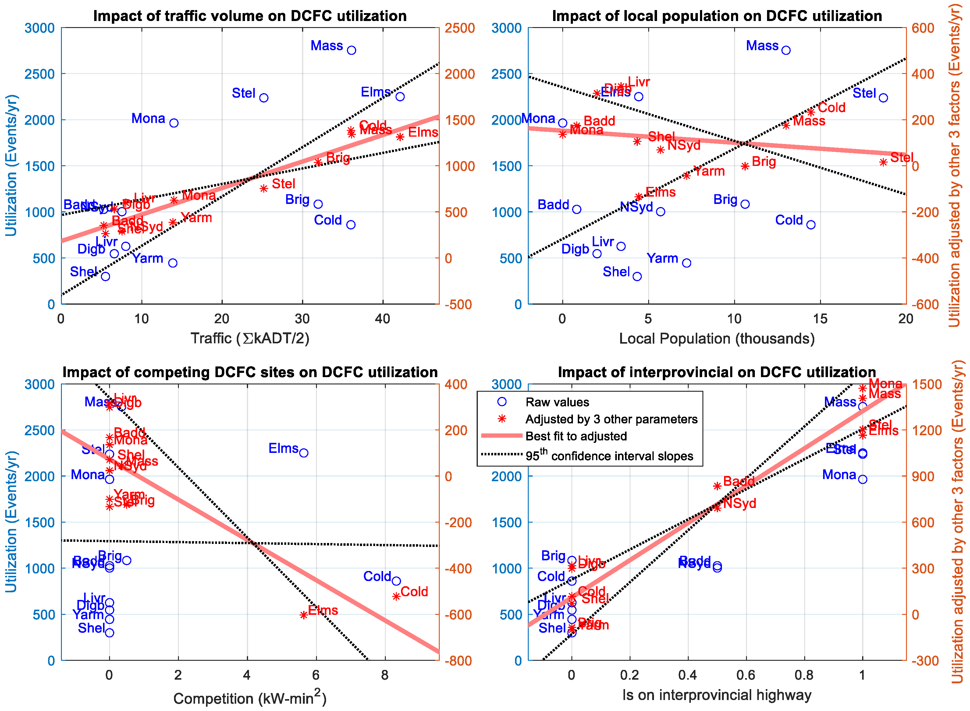
3. Regression Method and Results

3.1. Linear Regression

A four-variable linear regression was used to describe the predictive value of each of the four geographic explanatory variables. A linear regression finds the values of coefficients an in Equation (3) to minimize the root mean square of Pred—Observed values across twelve i sites. Note that no linear/constant variable was included, as a site with zero traffic, zero population, zero competition, and not on an interprovincial route would be expected to attract zero charging demand. The regression was performed using the Matlab function regress.
P r e d i = a 1 × T r a f i + a 2 × P o p i + a 3 × C o m p i + a 4 × I n t e r P r o v i
The input (explanatory) and output (response) variables described in Section 2.2, Section 2.3, Section 2.4 and Section 2.5 are tabulated in Table 1 for the 12 sites. The regression output column (rightmost column in Table 1) is the value Predi calculated by the products of the regression coefficients an and their respective predictive variables for each site. The mean absolute percent error in predicted utilization is 18%, while the RMS error is 25%, driven by small absolute errors in sites with low annual utilization.

3.2. Fitting Parameters

The coefficients used in the best fit of the explanatory variables to the observed DCFC utilization are listed in Table 2 (second column from right, bold), along with the 95th percent confidence range of the coefficient values found by the fitting algorithm.
Table 2 gives some idea of the confidence in each of the variables. The magnitudes of the coefficients vary dramatically, but note that a portion of these differences relate to the magnitudes of the variables.
To visualize the impact and uncertainty of the explanatory variables within the four-parameter fit, the utilization of each of the 12 sites can be plotted against each of the variables. The effects of the regression can be similarly visualized by plotting the utilization of each site adjusted by the three other coefficients against the metrics for that site, e.g., to see the impact of traffic volume on site utilization in isolation, the utilization of each site i can be reduced by a2 ×  Popi, a3 ×  Compi, and a4 ×  InterProvi, and these adjusted values can be plotted against the site traffic volumes Traffici.
Figure 5 shows both the unadjusted utilization (blue circles, left y-axis values) and the adjusted utilization (red stars, right y-axis values) for each of the sites. Each of the four explanatory variables is addressed in a separate plot within Figure 5, with traffic volume in the top left plot, local population in the top right plot, competition in the bottom left plot, and being on an interprovincial route in the bottom right plot. In each plot, the best fit line of the adjusted utilizations is shown as a thick red line to show the relationship between the remaining explanatory variable (x-axis) and utilization (y-axis). The 95th percentile range of coefficients is indicated by black dotted lines.
Figure 5 shows that the different explanatory variables have wide-ranging impacts (slope of the red line) and certainties (spread of slopes of the black dotted 95% confidence interval lines). For example, the ‘Interprovincial Route’ metric (bottom right plot in Figure 5) shows quite tight clustering and a distinct slope, while the ‘Local Population’ metric (top right plot in Figure 5) shows a lot of scatter, little slope in the best fit line, and a range of relationships in the 95% confidence interval that covers both positive and negative correlations.

3.3. Normalized Value Analysis

The magnitude of the fitting coefficients ai indicated in Table 2 likewise vary widely. This variation in magnitude, however, is impacted by the magnitudes of the explanatory variables, which vary by a factor of 40 (and this is only because population and traffic volumes were expressed in thousands throughout the fitting process). To better understand the relative importance of the geographic explanatory variables on DCFC utilization, the explanatory and output variables at each site can be normalized by the average of the values of all sites to represent a percentage greater than or less than the average using Equation (4).
N o r m a l i z e d i = 100 × V a r i a b l e i m e a n V a r i a b l e 1
Because of the construction of Equation (4), a site that has a value of zero in a metric will be represented as a decrease of 100% (from the mean), while a site that has a value of three times the mean will be represented as an increase of 200%. Re-running the Matlab fitting function regress, a new set of coefficients ai is produced for the four normalized explanatory variables, along with corresponding 95th % confidence interval coefficients. These are tabulated as before in Table 3.
The normalized coefficients are of interest since they describe the relative importance of the different explanatory variables. The most notable observation from Table 3 is that the traffic and interprovincial route variables have much larger coefficients (higher impacts) than population or competition. These two parameters could be loosely mapped to intraprovincial and interprovincial long distance travel, respectively, though specific data on origins and destinations of DCFC users was not available. Significantly, the magnitude of the population coefficient is only about 3% that of traffic or interprovincial, and the range encompassed by the 95% confidence interval extends to both significantly positive and significantly negative relationships. Interestingly, even at the edges of the 95% interval, population could only be ~50% as important as traffic (0.114 or 0.143 vs. 0.226).
In Figure 6, four subplots show the values of each of traffic (top left), local population (top right), competing DCFC sites (bottom left), and being on an interprovincial travel route (bottom right, refer to Section 2.5), normalized by Equation (4) and adjusted by each of the three other explanatory variables. As in Figure 5, red stars indicate the values of the 12 individual sites, the best linear fit is indicated with a thick red line, and the 95th percent confidence interval of linear fit is shown by two black dotted lines.
Note that in Figure 6, the degree of apparent ‘scatter’ in the subplots of adjusted data (adjusted by the three other explanatory variables) is primarily a function of the slope of the linear fit. I.e., where the data do not have a steep slope, the scatter looks more dramatic because the total y-axis range is reduced. Note that the range of y-values in any of the subplots at any x-axis value is roughly 30 (events/year) or less.

4. Discussion of Key Results

The impact of traffic passing near a DCFC site has a clear, positive impact on the utilization. The mechanism behind this impact is intuitive; more traffic means more EVs passing, which in turn means more vehicles seeking charge. Similarly, independent of the quantity of passing traffic, being on a key interprovincial travel route is also highly determinative of the demand for charging. This may be a function of the importance of tourist traffic, which is not only comprised disproportionately of vehicles that do not have a ‘home’ charging location but also may be made up of vehicles that are traveling to a more distant destination than the population in general. In the context of Nova Scotia in particular, where the EV adoption rate lags that of other parts of Canada, this interprovincial traffic may likewise consist of a higher proportion of EVs than ‘local’ traffic.
The low relative value of competition, being only ~15% as important as traffic and indicating that a 100% increase in competition (doubling a DCFC site capacity) only decreases utilization by 6%, rather than a more intuitive 50% decrease, is curious. One possible explanation is that EVs seeking charge preferentially choose routes through areas with lots of charging options, analogous to the speculated benefits of charging hubs described in [17], i.e., the observed coefficient is reasonably accurate because a DCFC-rich route attracts a higher fraction of EVs within the traffic. This effect may take place on the scale of individual trips and route choices by EV drivers, or may take place on the scale of social structure, i.e., people who know there are more charging options in their area or along their frequented routes may be more likely to choose an EV, a view supported by other research [8,32,33]. A second possibility is that the metric used to measure DCFC competition, detailed in Section 2.4, is not well formulated, so inadequately captures the actual relationship, i.e., the observed coefficient is not necessarily accurate due to poor formulation. A third possibility is simply that there is insufficient data, i.e., that the four sites with non-zero values of competition used in the regression were simply insufficient to properly isolate the impact of that explanatory variable from other, unrepresented, variability between sites.
The effect of local population is ambiguous, which is consistent with the two possible contradictory mechanisms by which population could impact utilization discussed in Section 2.3. First, a higher population could indicate a commuter destination, and commuters in EVs will likely visit DCFCs at a lower rate than the general population (specifically, lower than long-distance travelers). Or second, that a higher population could indicate a higher prevalence of EV owners who do not have a dedicated ‘home’ charging location, so charge at their local DCFC more than the general population. Some efforts have been taken to disambiguate these two possible mechanisms by quantifying the number of rental residential units listed on classified fora within a fixed distance of each charger. However, (1) the data sources available to populate such explanatory variables are imprecise, particularly given the recent surge in population in the region, and (2) adding too many explanatory variables to a 12-point fitting is likely to produce deceptive results.
The authors do not anticipate that all other datasets will produce identical results, so the coefficients associated with these explanatory variables may be considered a first foray into this kind of investigation. As a future research endeavor, other researchers with access to comparable datasets are encouraged to compare their observed relationships, and having additional sites and a higher total site count could permit the inclusion of additional explanatory variables.

5. Conclusions and Policy Implications

The predominant policy implication of this work is that DCFC sites in areas of high traffic realize more utilization than areas in lower traffic. This rule applies both to generic traffic volume counts and particularly to corridors where long-distance travel (in this analysis, specifically interprovincial travel) may make up a larger fraction of the traffic count than may be present in the general population.
Another implication of this analysis is that corridors with abundant access to charging may attract EV traffic, such that additional charging infrastructure cannibalizes utilization from existing infrastructure at lower rates than intuition would suggest. This effect may operate over short timescales, e.g., route planning by EV drivers, or over longer timescales that could be assessed in this work, e.g., increased EV adoption rates along corridors with more abundant DCFC infrastructure. Combining these two findings, this work seems to support prioritizing EV charging at hubs on major corridors.
Taken in aggregate, this research is informative to DCFC infrastructure planning. Previous work by the authors established a bottom–up charging demand equation presented in [17] as Equation (1). This research offers further insight into appropriate values (or appropriate variations in the values by location) or the final term of that equation, FDC, which describes the fraction of electrical energy supplied by DCFC among the traffic within the ‘catchment’ of a charging hub. These findings may inform researchers and planners how that parameter should be varied as a function of the geographic explanatory variables described here.

Author Contributions

Conceptualization, N.J. and N.S.P.; methodology, N.S.P. and N.J.; software, N.J.; validation, N.S.P., N.J. and L.G.S.; formal analysis, N.S.P. and N.J.; investigation, N.S.P., N.J. and L.G.S.; resources, L.G.S.; data curation, L.G.S.; writing—original draft preparation, N.S.P.; writing—review and editing, N.S.P., N.J. and L.G.S.; visualization, N.S.P. and N.J.; supervision, L.G.S. and N.S.P.; project administration, L.G.S.; funding acquisition, L.G.S. All authors have read and agreed to the published version of the manuscript.

Funding

This research was conducted as part of a larger project in collaboration with Halifax Regional Municipality (HRM), with funding support from HRM and from the Nova Scotia Department of Natural Resources and Renewables. We extend our thanks to Nova Scotia Power Inc. for sharing the DCFC data.

Data Availability Statement

Links to publicly available data used in this study as explanatory variables are referenced in Section 2 Data and Methods. The DCFC utilization data (Section 2.1 Charging Event Data), were shared by Nova Scotia Power Inc. with the authors under a non-disclosure agreement, so unfortunately cannot be made public.

Conflicts of Interest

The authors declare that there are no conflicts of interest other than that of EV drivers. They wish there was a more comprehensive and higher-power EV charging infrastructure. The funders had no role in the design of this study, in the collection, analysis, or interpretation of data, in the writing of the manuscript, or in the decision to publish the results.

References

  1. International Energy Agency. Global EV Outlook 2024; Moving Towards Increased Affordability. International Energy Agency: Paris, France, April 2024; Available online: https://iea.blob.core.windows.net/assets/a9e3544b-0b12-4e15-b407-65f5c8ce1b5f/GlobalEVOutlook2024.pdf (accessed on 9 July 2024).
  2. Levy, J.; Riu, I.; Zoi, C. The Costs of EV Fast Charging Infrastructure and Economic Benefits to Rapid Scale-Up. EVgo Fast Charging. May 2020. Available online: https://a.storyblok.com/f/78437/x/f28386ed92/2020-05-18_evgo-whitepaper_dcfc-cost-and-policy.pdf (accessed on 9 July 2024).
  3. Bunce, L.; Harris, M.; Burgess, M. Charge up then charge out? Drivers’ perceptions and experiences of electric vehicles in the UK. Transp. Res. Part A Policy Pract. 2014, 59, 278–287. [Google Scholar] [CrossRef]
  4. Wood, E.; Rames, C.; Muratori, M.; Raghavan, S.; Melaina, M. National Plug-In Electric Vehicle Infrastructure Analysis. USA Dept Energy 2017, 1393792. [Google Scholar] [CrossRef]
  5. Baresch, M.; Moser, S. Allocation of e-car charging: Assessing the utilization of charging infrastructures by location. Transp. Res. Part A Policy Pract. 2019, 124, 388–395. [Google Scholar] [CrossRef]
  6. Bräunl, T.; Harries, D.; McHenry, M.; Wager, G. Determining the optimal electric vehicle DC-charging infrastructure for Western Australia. Transp. Res. Part D Transp. Environ. 2020, 84, 102250. [Google Scholar] [CrossRef]
  7. Schulz, F.; Rode, J. Public charging infrastructure and electric vehicles in Norway. Energy Policy 2022, 160, 112660. [Google Scholar] [CrossRef]
  8. MacKenzie, D.; Jabbari, P.; Khaloei, M. Locating Fast Charging Stations for Safe and Reliable Intercity Electric Vehicle Travel in Washington; Pacific Northwest Transportation Consortium: Washington, WA, USA, 2018. [Google Scholar]
  9. Illmann, U.; Kluge, J. Public charging infrastructure and the market diffusion of electric vehicles. Transp. Res. Part D Transp. Environ. 2020, 86, 102413. [Google Scholar] [CrossRef]
  10. Miele, A.; Axsen, J.; Wolinetz, M.; Maine, E.; Long, Z. The role of charging and refuelling infrastructure in supporting zero-emission vehicle sales. Transp. Res. Part D Transp. Environ. 2020, 81, 102275. [Google Scholar] [CrossRef]
  11. U.S. Department of Transportation. Biden-Harris Administration Takes Key Step Forward in Building a National Network of User-Friendly, Reliable, and Ac-cessible Electric Vehicle Chargers|US Department of Transportation. US-DOT. June 2022. Available online: https://www.transportation.gov/briefing-room/biden-harris-administration-takes-key-step-forward-building-national-network-user (accessed on 27 September 2024).
  12. Pearre, N.S.; Swan, L.G. Observational Evaluation of the Maximum Practical Utilization of Electric Vehicle DCFC Infrastructure. World Electr. Veh. J. 2022, 13, 190. [Google Scholar] [CrossRef]
  13. Rempel, D.; Cullen, C.; Bryan, M.M.; Cezar, G.V. Reliability of Open Public Electric Vehicle Direct Current Fast Chargers. Hum. Factors 2023, 66, 2528–2538. [Google Scholar] [CrossRef]
  14. Nelder, C.; Rogers, E. Reducing EV Charging Infrastructure Costs. Rocky Mt. Inst. 2019, 48. [Google Scholar] [CrossRef]
  15. Tesla. Find Us|Tesla. Available online: https://www.tesla.com/en_ca/findus? (accessed on 27 September 2024).
  16. Wu, Y.; Ribberink, H. Methodology to Estimate the Need for Direct-Current Fast-Charging Stations along Highways in Canada. J. Transp. Eng. Part A Syst. 2020, 146, 04020108. [Google Scholar] [CrossRef]
  17. Pearre, N.S.; Swan, L.G.; Burbidge, E.; Balloch, S.; Horrocks, L.; Piper, B.; Anctil, J. Regional Electric Vehicle Fast Charging Network Design Using Common Public Data. World Electr. Veh. J. 2022, 13, 212. [Google Scholar] [CrossRef]
  18. He, Y.; Kockelman, K.M.; Perrine, K.A. Optimal locations of U.S. fast charging stations for long-distance trip completion by battery electric vehicles. J. Clean. Prod. 2019, 214, 452–461. [Google Scholar] [CrossRef]
  19. Khan, H.O.A.; Saeed, F.; Arshad, N. Propelling the Penetration of Electric Vehicles in Pakistan by Optimal Placement of Charging Stations. Eng. Proc. 2021, 11, 34. [Google Scholar] [CrossRef]
  20. Nie, Y.M.; Ghamami, M. A corridor-centric approach to planning electric vehicle charging infrastructure. Transp. Res. Part B Methodol. 2013, 57, 172–190. [Google Scholar] [CrossRef]
  21. Luo, Q.; Tian, W.; Jia, H. Location and Capacity Model of Charging Station for Electric Vehicles Based on Commuting Demand. IEEJ Trans. Electr. Electron. Eng. 2020, 15, 1089–1099. [Google Scholar] [CrossRef]
  22. Csonka, B.; Csiszár, C. Determination of charging infrastructure location for electric vehicles. Transp. Res. Procedia 2017, 27, 768–775. [Google Scholar] [CrossRef]
  23. Bundale, B.M. Nova Scotia Power to Build Electric Vehicle Fast-Charging Network in Province. CityNews Halifax, Halifax. 6 March 2018. Available online: https://halifax.citynews.ca/2018/03/06/nova-scotia-power-to-build-electric-vehicle-fast-charging-network-in-province/ (accessed on 19 July 2024).
  24. Nova Scotia. Traffic Volumes—Provincial Highway System. Nova Scotia Open Data. Available online: https://data.novascotia.ca/Roads-Driving-and-Transport/Traffic-Volumes-Provincial-Highway-System/8524-ec3n (accessed on 27 September 2024).
  25. Google. Google Maps. Available online: https://www.google.com/maps (accessed on 24 July 2024).
  26. Statistics Canada. Canada’s National Statistical Agency. Available online: https://www.statcan.gc.ca/en/start (accessed on 22 July 2024).
  27. Wikipedia. The Free Encyclopedia. Available online: https://www.wikipedia.org/ (accessed on 22 July 2024).
  28. AreaVibes. Best Places to Live in the US & Canada. Available online: https://www.areavibes.com/ (accessed on 22 July 2024).
  29. Webb, M. Charging Electric Vehicles: Developing Policy Options to Accommodate the at Home Charging of Garage Orphan Electric Vehicles in the Metro Vancouver Region. Available online: https://open.library.ubc.ca/soa/cIRcle/collections/undergraduateresearch/52966/items/1.0300459 (accessed on 19 July 2024).
  30. Tesla. Opening the North American Charging Standard|Tesla Canada. Available online: https://www.tesla.com/en_ca/blog/opening-north-american-charging-standard (accessed on 27 August 2024).
  31. Electric Vehicle Registration Data | Open Data|Nova Scotia. Available online: https://data.novascotia.ca/Permits-and-Licensing/Electric-Vehicle-Registration-Data/avxy-ifhs/about_data (accessed on 27 August 2024).
  32. Ledna, C.; Muratori, M.; Brooker, A.; Wood, E.; Greene, D. How to support EV adoption: Tradeoffs between charging infrastructure investments and vehicle subsidies in California. Energy Policy 2022, 165, 112931. [Google Scholar] [CrossRef]
  33. Greene, D.L.; Muratori, M.; Kontou, E.; Borlaug, B.; Melaina, M.; Brooker, A. Quantifying the Tangible Value of Public Electric Vehicle Charging Infrastructure; NREL/TP-5400-70340; California Energy Commission: Sacramento, CA, USA, 2020. [Google Scholar] [CrossRef]
Figure 1. Locations of the 12 monitored DCFC sites around Nova Scotia. The location of Nova Scotia within Canada is shown inset, top left.
Wevj 15 00445 g001
Figure 2. Utilization factor (average power normalized by rated power over a 30-day window) delivered by each of the 12 chargers in Nova Scotia through the full dataset.
Wevj 15 00445 g002
Figure 3. An example of implementation of the traffic volume calculation. A ‘control volume’ (red dotted circle) is defined by the area around the Elmsdale DCFC site (red star), and vehicles entering and exiting that volume are summed. Background map from Google Maps [25].
Wevj 15 00445 g003
Figure 4. Map of highways at their value as ‘Interprovincial Routes’ as ascribed in this analysis. Thick red lines show routes attributed a value of 1, while thin red lines show routes attributed a value of 0.5. Important ferry links to Newfoundland and Prince Edward Island are shown as dark blue lines. The location of the provincial capital Halifax is indicated with a red star.
Wevj 15 00445 g004
Figure 5. Four fitting parameters are described visually. In each plot, the annual utilization of each of twelve sites (left y-axis) is plotted against one of the four fitting parameters (x-axis) as a blue circle. The annual utilization adjusted by each of the other three fitting parameters (right y-axis) is plotted as a red star.
Wevj 15 00445 g005
Figure 6. Four normalized fitting parameters are described visually. In each subfigure, the difference in annual utilization of each of twelve sites relative to the average utilization (y-axis) is plotted against the difference in the adjusted, fitting parameters (x-axis) relative to the average of that parameter as a red star.
Wevj 15 00445 g006
Table 1. Explanatory geographic parameters of each of the 12 DCFC sites (second through fifth columns), the corresponding observed number of charging events per year (sixth column), and the regression predicted event count (seventh column).
LocationTraffic
Volume
PopulationCompetitionInterProv
Highway
Observed Events/yPredicted Events/y
(units)(kADT)(1000s)(kW × min2)(/)(count)(count)
Baddeck5.30.8000.51027860
Bridgewater31.910.60.50010841170
Coldbrook36.014.48.320860743
Digby6.62.000546248
Elmsdale42.14.45.641.022502420
Liverpool8.03.400626309
Masstown36.113.00.351.027532682
Monastery14.00.001.019641828
North Sydney7.55.700.51002978
Shelburne5.54.300299228
Stellarton25.218.701.022372370
Yarmouth13.97.200445546
Table 2. Regression coefficients for each of the four geographic explanatory variables, with 95th percent confidence interval coefficients.
Variable(units)LowerBest aUpper
Traffic, a1(Events/kADT)173553
Population, a2(Events/kPop)−23839
Competition, a3(Events/Comp)−152−77−2
InterProv, a4(Events/InterProv)98013351690
Table 3. Fitting coefficients of normalized explanatory variables.
Variable(units)LowerBestUpper
Traffic(%/%)0.2260.4450.664
Population(%/%)−0.1140.0150.143
Competition(%/%)−0.116−0.062−0.008
InterProv(%/%)0.3430.4280.514
Disclaimer/Publisher’s Note: The statements, opinions and data contained in all publications are solely those of the individual author(s) and contributor(s) and not of MDPI and/or the editor(s). MDPI and/or the editor(s) disclaim responsibility for any injury to people or property resulting from any ideas, methods, instructions or products referred to in the content.

