Abstract
Urbanization processes are some of the key drivers of spatial changes which shape and influence land use and land cover. The aim of sustainable land use policies is to preserve and manage existing resources for present and future generations. Increasing access to information about land use and land cover has led to the emergence of new sources of data and various classification systems for evaluating land use and spatial changes. A single globally recognized land use classification system has not been developed to date, and various sources of land-use/land-cover data exist around the world. As a result, data from different systems may be difficult to interpret and evaluate in comparative analyses. The aims of this study were to compare land-use/land-cover data and selected land use classification systems, and to determine the influence of selected classification systems and spatial datasets on analyses of land-use structure in the examined area. The results of the study provide information about the existing land-use/land-cover databases, revealing that spatial databases and land use and land cover classification systems contain many equivalent land-use types, but also differ in various respects, such as the level of detail, data validity, availability, number of land-use types, and the applied nomenclature.
1. Introduction
The 21st century is a time of continuous and dynamic changes in land management. Urbanization has been proceeding rapidly and is using significant tracts of previously unmanaged land. Sustainable management of land, as well as environmental and anthropogenic resources, requires a thorough knowledge of land-use structure and changes in land use, in particular in urbanized land that is subjected to human pressure.
1.1. Sustainable Land Use and Land-Use Structure
Anthropogenic pressure is one of the main drivers of change in space which directly affects land-use structure [1,2,3]. Changes in land-use structure transform the natural environment and, indirectly, lead to changes in climate and biodiversity [4,5,6]. Land-use structure is affected by geographic location; policies implemented at the local, regional, and national level; socioeconomic situation; spatial features that determine potential development strategies in a given area; existing land-use types; a need to address and resolve the consequences of misguided planning decisions; provision of local zoning plans and zoning decisions; restructuring measures implemented in a given area; as well as guidelines for rational land management [7,8,9]. Despite the adoption of numerous legal acts aimed at protection of the environment and promotion of sustainable development, poorly designed legislation can exert a negative impact on land-use structure [10]. Sustainable land use is influenced by socioeconomic processes that affect spatial development, and by the effectiveness of land planning and land management tools that regulate these processes [11].
Sustainable land use has been addressed by the Sustainable Development Goals of the 2030 Agenda for Sustainable Development. Rational land management can play a key role in counteracting climate change and protecting biological diversity, while contributing to social welfare and economic growth. In view of ongoing urban expansion, integrated approaches for planning development of both urban and suburban areas should be supported to ensure sustainable land-use planning [12]. Therefore, land management and planning policies should promote a harmonious balance between the natural environment and changes resulting from human activity. The implemented policies should encourage sustainable management of the natural and urbanized environment to ensure that the existing resources are managed responsibly, therefore, meeting the needs of the present and future generations [13].
Land-use analyses are the main sources of information for assessing the extent to which social, economic, and environmental factors affect urbanization processes and spatial structure [14]. A thorough knowledge of existing land-use patterns and changes in land use over time is essential for analyzing spatial processes and problems and for implementing land management policies that maintain or improve living standards and the quality of life [15]. Analyses of land-use structure enable diagnoses of spatial arrangement in a studied area, the existing state of land development, intensity of land development projects, and the influence of anthropogenic pressure in the evaluated area. Information about spatial development, including land-use structure, plays a key role in planning processes and environmental management [16,17]. Spatial and functional structure depicts the distribution of various land-use types (functions) and their proportions in an analyzed area [18]. As a result, studies on land-use structure have focused on land-use patterns in different types and categories of land. According to Pei et al. [18], urban land-use types can be identified based on their physical appearance (such as the reflection or texture coefficient) or social function. Urban and suburban areas are characterized by the most rapid growth. Urban functions generally carry greater economic weight than other types of land use, which implies that agricultural functions in urban areas cannot be effectively protected against progressing urbanization [9]. Urban areas are also characterized by considerable fragmentation and spatial diversification of different land-use types, which is why the existing state and changes in land use/land cover should be investigated in urbanized areas that are subjected to anthropogenic pressure [19]. A thorough knowledge of the distribution and area of various land-use types, as well as changes in their proportions, is needed in local and regional planning [15]. Land-use analyses and the generated land-use maps can support decision-making in sustainable development, and they constitute a valuable source of knowledge for predicting future changes in space [3].
1.2. Analysis and Sources of Land-Use/Land-Cover Data
Research studies aimed at analyzing land-use/land-cover structures have been conducted around the world. Increasing access to information about land use/land cover leads to the emergence of new sources of data and various classification systems for evaluating land use and spatial changes [20]. The rapid development of software tools has considerably enhanced research into land use/land cover. Geographic Information Systems (GIS) are widely used in urban development and planning to analyze land-use structure and changes in space [21,22,23]. Contemporary research on land-use structure relies on satellite data [24,25]. Various types of remotely sensed data acquired by Landsat satellites have been used since the early 1970s for identifying land-use structure [26]. Remote sensing techniques capture the physical features of land use and are considered to be the key methods of classifying urban land use [18]. Digital archives of remotely sensed data have facilitated studies on historical changes in land use/land cover, including those related to environmental and anthropogenic factors [1,3]. Other methods and data sources for examining land-use structure have also been described in the literature, including field surveys, spatial inventories, geosurveys, geolocation methods, public registers, mobile data, social media, and others [2,27,28,29,30,31,32].
The Copernicus program for monitoring the Earth is an important source of information on land use/land cover. Data are collected from various sources, including Earth observation satellites and in situ sensors. As part of the program, remotely sensed data on land use/land cover can be acquired from the CORINE Land Cover repository covering the territory of Europe. Local data are also available, and they supply more detailed information about land use/land cover in areas confronted with various environmental challenges and problems [33]. Valuable information about land use/land cover can also be obtained from the Urban Atlas whose geographic cover is limited to functional urban areas (FUAs) [34,35,36,37]. Data on riparian zones, coastal zones, and Natura 2000 areas are also available [33]. A cadaster is a conventional and widely used source of information about land use, which is a public register of land, buildings, property owners, and tenants and cadaster data are widely used in land-use analyses [38,39,40]. In Poland, official sources of land-use data include the Database of Topographic Objects (DBTO10k) and the cadaster which is referred to as the Land and Building Register [41,42].
1.3. Research Objectives
Regardless of the selected research method, the adopted land use/land cover classification and sources of data have to be sufficiently detailed for the needs of the planned analyses. A single globally recognized land use classification system has not been developed to date, and various sources of land-use/land-cover data exist around the world. Land management has been investigated in multiple fields of science, and various approaches have been deployed in land-use structure analyses, which has led to the emergence of numerous land use classification systems [40]. The evolution of various land use/land cover classification systems has been driven by national and international initiatives, and these systems have been developed for various purposes, which is why they differ in nomenclature and specific attributes [43]. Therefore, the present study aimed at answering the following research questions: What information do land use/land cover classifications and spatial databases provide, and what are the similarities, differences, and limitations?
In view of the above questions, the aim of this study, was to compare land-use/land-cover data in selected land classification systems to determine the influence of land use/land cover classification and spatial data on analyses of land-use structure in urbanized areas and areas subjected to anthropogenic pressure, using the example of Poland. Land use classification systems that are directly linked with spatial databases were identified for the purpose of automating the analytical process, for example, with the use of GIS software. This study was also undertaken to generate information about existing databases and to discuss their strengths, weaknesses, and limitations. The research hypothesis postulates that land use/land cover classification systems and databases differ in the level of detail, data validity, availability, as well as the number of land-use/land-cover categories. It was also assumed that classification systems that are cross referenced with spatial databases contain a higher number of land-use types than systems that are developed for the needs of thematic scientific analyses. An attempt was also made to determine whether the number of land-use types in the analyzed classification systems correlated with the level of detail in the spatial datasets.
The discussed problem has practical relevance because a single universally accepted classification system or spatial database have not been developed to date. Urbanization proceeds at a different rate in various parts of the world, and the present status of land and changes in land management have to be monitored in urbanized areas and areas subjected to anthropogenic pressure. Therefore, special attention was paid to built-up and urbanized areas. These areas change dynamically, and their layout is closely associated with physical and geographic factors. Urban areas have to be effectively monitored to guarantee that their expansion is consistent with the goals of sustainable development.
2. Materials and Methods
Knowledge of land-use structure plays a very important role in land management analysis, in particular in areas that are subjected to anthropogenic pressure [17]. The selection of an appropriate land use classification method and data source support the acquisition of reliable results with a sufficient level of detail for describing the evaluated area.
2.1. Research Stages, Data Sources, and Methods
The adopted research goals were pursued in stages, as outlined in Figure 1.
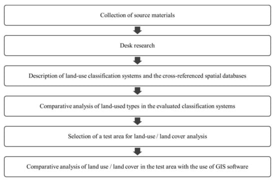
Figure 1.
Stages of research.
The study involved desk research and a comparative analysis of the collected source materials with the use of cartographic methods. Source materials were collected in the first stage of the research. The existing land use classification systems were analyzed in the context of formal classification systems that are regulated by legal provisions and are based on cadastral data, CORINE Land Cover data, or Urban Atlas data, as well as informal classification systems that are created based on research results or the existing classification systems and are used for specific analytical needs [42,44,45,46].
The following land use classification systems were selected for analysis:
- CORINE Land Cover (CLC) [45];
- Urban Atlas (UA) [46];
- Database of Topographic Objects (DBTO10k) [41];
- Polish cadaster (Land and Building Register) [42];
- Land use classification proposed by Anderson et al. [15];
- Land use classification proposed by Pei et al. [18];
- Land use classification proposed by Jia et al. [27];
- Land use classification proposed by Huang et al. [44].
In the next stage of the study, the selected land use classification systems were evaluated for their thematic scope, level of detail, and the number of land-use types. The availability of spatial data relating to land management in the examined classification systems was verified by establishing whether the analyzed systems are directly referenced with spatial data in the existing databases and whether these databases are publicly available. The availability of spatial data had to be checked because some classification systems are directly linked with maps containing spatial data on land management (such as the Urban Atlas and the Database of Topographic Objects), whereas in other systems, users have to generate their own maps or modify the existing map resources based on the characteristic attributes of the presented land-use types.
Then, the selected classification systems were compared. Only land use classification systems that were cross referenced with spatial databases were taken into consideration at this stage of the research. Each system was analyzed, and classifications that were cross referenced with spatial databases were listed in a table presenting land-use types. To account for the fact that global land resources have been subjected to growing urbanization pressure which has increased the area of urbanized and built-up land, two main categories of land use were listed in the table. i.e., built-up and urbanized land and undeveloped land (open space). This division supported a more accurate comparison of the analyzed classification systems in terms of land-use types identified in both categories.
In the last stage of the study, the test area was selected, and its land-use structure was analyzed based on the data acquired from publicly available spatial databases. The strengths, weaknesses, limitations, quality, validity and availability of data, the number of land-use types identified in the test area, and the degree of data generalization were analyzed. An urbanized area that had been subjected to anthropogenic pressure was selected for the needs of this study to identify the differences and similarities among the evaluated databases. Changes in land-use structure proceed most rapidly in urbanized areas which are characterized by considerable fragmentation of land-use/land-cover types and a high number of diverse land-use types. The selected test area was a city with the surrounding suburban zones. Spatial data were acquired from the following three publicly available databases: CORINE Land Cover (CLC), Urban Atlas (UA), and the Database of Topographic Objects (DBTO10k). These data were compared with an orthophoto map depicting land-use types in the analyzed area. The CLC uses a minimum mapping unit of 25 hectares for areal phenomena and a minimum width of 100 m for linear phenomena. Thematic accuracy is ≥85% [45]. The Urban Atlas uses a minimum mapping unit of 0.25 ha for urban classes and 1 ha for the rural classes and a minimum width of 10 m for linear phenomena. The image resolution is 2.5 m [46]. The CORINE Land Cover data and the Urban Atlas data are provided in separate databases (both for the vector and raster versions). The accumulated data in the DBTO10k correspond to topographic maps in 1:10,000 scale [41]. The DBTO10k resources are available via WMS (Web Map Service) and in the vector version. The orthophoto map is characterized by a pixel size of 25 cm. The validity, coverage, and sources of the evaluated databases are presented in Table 1. Data were analyzed with the use of GIS tools, including licensed ArcGIS software and QGIS open-source platform. For research purposes, the available WMS/WMTS (Web Map Service/Web Map Tile Service) services (CLC, UA, and orthophoto map) and data in GML file format (DBTO10k) were used.

Table 1.
Validity, coverage and sources of data in the analyzed databases in the test area.
2.2. Study Area
The studied area was the city of Olsztyn and the surrounding suburban zones. Olsztyn is situated in the Polish Voivodeship of Warmia and Mazury (Figure 2), and it had a population of 171,979 in 2019 [47]. Olsztyn was selected for the study because it is a voivodeship capital and a functional urban area (FUA). Olsztyn is an urban center at the domestic level, and it fulfills selected metropolitan functions at the domestic and international level. The studied area features diverse land use categories and typologically different zones, including urban areas (with high development density), suburban/transitional areas (peripheral areas with lower development density, and the coexistence of highly developed and undeveloped land), and rural areas with a predominance of undeveloped land and natural land cover.
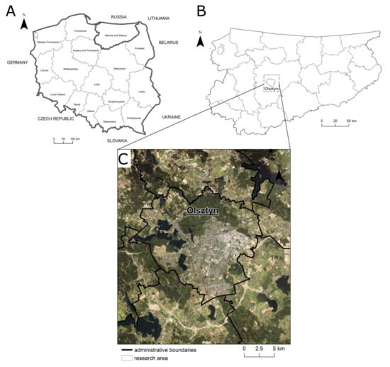
Figure 2.
Location of the test area (C) in Poland (A) and in the Voivodeship of Warmia and Mazury (B).
3. Results
In line with the adopted methodology and research stages, basic information about the analyzed land use classification systems are described Section 3.1. The selected classification systems are compared in Section 3.2, and their applicability for analyzing land-use structure in urbanized areas is evaluated in Section 3.3.
3.1. Description of the Analyzed Land Use Classification Systems and Data Sources
CORINE Land Cover (CLC) is one of the most common sources of data on land-use structure [21,24,25,48]. The CORINE Land Cover project was established by the European Union, and it is coordinated by the European Environment Agency. The CORINE Land Cover (CLC) inventory was initiated in 1985, and it was updated in 2000, 2006, 2012, and 2018 [45]. CORINE Land Cover (CLC) data provide valid and regularly updated information about land use/land cover in Europe, and it presents changes in the evaluated parameters across time intervals. The CLC uses a minimum mapping unit of 25 hectares for aerial phenomena and a minimum width of 100 m for linear phenomena. The CORINE Land Cover data are universal and widely available, which facilitates the use of the adopted land-use classification system. In most countries, CLC technology has been implemented based on a visual interpretation of high-resolution satellite images. Some countries have introduced semiautomatic solutions that rely on both satellite images and data collected in situ [45]. The CLC program currently covers 39 countries. The CLC features one of the most detailed land use classification systems in the world, where land-use data are presented at three levels (Table 2). Level 1 includes the five main types of land use; Level 2 covers 15 land-use types; and the third and most detailed level features 44 land-use types [49]. The CLC is cross referenced with a spatial database that is available for use in the public domain at no charge.
Table 2.
Hierarchical classification of land-use types in the CORINE Land Cover (CLC) inventory.
The Urban Atlas is also a major source of land-use/land-cover data which covers functional urban areas (FUAs). The Urban Atlas contains detailed information about land use/land cover for urbanized areas in Europe, and it covers the majority of European cities with a population higher than 50,000. The Urban Atlas was developed in 2006, and its coverage was expanded from 301 European cities in 2016 to 696 cities in 2018. This data repository was last updated in 2018. Maps covering cities that have not yet been included in the Urban Atlas are being developed, and the project will ultimately cover 788 FUAs. The minimum mapping unit is 0.25 ha for urban classes and 1 ha for the remaining classes. The land use/land cover classification features 17 urban classes (including five classes with different development densities) and 10 rural classes with non-urban land cover (Table 3) [46]. The classification system is cross referenced with a spatial database that is available to all users at no charge.
Table 3.
Hierarchical classification of land-use types in the Urban Atlas (UA).
In Poland, the cadaster is the official source of land-use data [50]. The Polish cadaster, referred to as the Land and Building Register, is a system that aggregates, updates, and generates information on land, buildings, and apartments. Data are presented at two levels of detail, and the cadaster features six land use categories that are divided into 26 classes (Table 4) [42]. In Poland, the information about the boundaries and numbers of cadastral parcels can be acquired from publicly available geoportals, but data relating to contours and land-use types are not customarily collected, and they are not widely available. In practice, cadastral data often deviate from the actual data. Such inconsistencies can be found among the actual boundaries of cadastral plots, boundaries and area of land plots, land-use types, and changes in land use as compared with those indicated in the Land and Building Register. The quality of cadastral data is improved by regularly updating the information in the Land and Building Register. The construction of a modern cadastral system in Poland is significantly impeded by the low accuracy of cadastral data and incomplete spatial data pertaining to cadastral objects [51].
Table 4.
Hierarchical classification of land-use types in the Polish cadaster (Land and Building Register).
The demand for detailed information about land-use types in Poland has prompted the development of national databases containing information about spatial development. The National Database of Topographic Objects (DBTO10k) is one such data source [41]. The accumulated data correspond to topographic maps, in 1:10,000 scale, which contain information about topographic objects, including main buildings and structures. The DBTO10k relies on state-run registers such as the Land and Building Register, Geodetic Register of Utility Infrastructure Networks, National Register of Boundaries and Areas of Territorial Units, National Register of Geographic Names, orthophoto maps, numerical terrain model, as well as registers kept by other authorities and institutions. The DBTO10k was developed in 2012–2013, and it continues to be expanded and updated. The database contains the following nine main categories of data: water supply networks, transport networks, utility infrastructure, land cover, buildings, structures, devices, co-existing land-use types, protected areas, administrative units, and other objects Data are available at three levels of detail. The first level is comprised of nine categories, the second level consists of 57 classes, and the third level includes 286 types of data. Land cover, namely the continuous classification of land-use types that play an important role in land-use studies, is one of the nine main categories of data. The land cover category features 12 land-cover types at Level 2, and 35 land-cover types at Level 3 (Table 5). Different categories of land cover are represented by homogeneous fragments of land with identical physical attributes. Land cover includes the main surface features that are identified based on their external appearance [41]. The DBTO10k is cross referenced with a spatial database which has been available for public use since 2020 [52].
Table 5.
Hierarchical classification of land-use types in the National Database of Topographic Objects (DBTO10k).
The multilevel land use and land cover classification system proposed by Anderson et al. [15] was developed to compensate for the absence of a standardized classification system. The classification system with definitions of various land-use types is presented in Table 6. The system contains nine land-cover types at Level 1 and 37 land-cover types at Level 2. The authors assumed that Levels 3 and 4 data would be generated by groups of local users to ensure that the selected categories accurately met the classification needs of a given area or region as well as the needs of research study.
Table 6.
The multilevel land use and land cover classification system proposed by Anderson et al. [15].
Less detailed informal land use classification systems have also been described in the literature. These systems have been developed to meet specific research needs, and the identified land-use types are universal and can be applied in various regions around the world. The main weakness of these classification systems is that they have not been cross referenced with spatial databases and are not provided in raster or vector version; therefore, the presented spatial data have to be recovered independently or modified based on the existing datasets. For example, the classification system proposed by Pei et al. [18] contains five land use categories that are based on aggregated mobile phone data, i.e., residential, business, commercial, open space, and other. Mobile phone positioning data and remote sensing imagery were used by Jia et al. [27] to analyze land-use structure. The cited authors focused on urbanized areas, and they identified six categories of urban land use, i.e., residential, business, entertainment, scenic, open space, and other.
Huang et al. [44] developed a land use classification system that is based on the Land Administration Law of the People’s Republic of China (GBT 21010-2017). They analyzed 12 land use categories (cultivated land, garden land, water and water conservancy facilities, woodland, grassland, residential land, commercial land, transportation land, industrial land, public management and public service land, special land, and other land) and selected the nine most important categories which were then modified for the needs of the conducted research. The selected land use categories were residential, commercial, educational, civic, transport, industrial, natural, agricultural, and other. Each land-use type was characterized.
Land use classification systems that are cross referenced with spatial databases (the first four systems presented in this subsection) are compared in the following subsection.
3.2. Comparative Analysis of Land Use Classification Systems
The selected land use classification systems were compared in the next stage of the study. Only systems that are cross referenced with spatial databases were taken into consideration. The evaluated systems contain universal land-use types that can be applied globally, and they account for urbanized areas and areas subjected to anthropogenic pressure and are subdivided into specific categories of land use. The analyzed land use classification systems are presented in Table 7. The last and the most detailed level of data were taken into consideration in the analysis. There were two categories of land use identified for in-depth analysis, i.e., built-up and urbanized land, and undeveloped land (open space). Land-use types were assigned to one of the above categories based on the characteristic attributes of each land-use type in the compared classification systems.
Table 7.
Comparative analysis of land-use classification systems.
The examined classification systems differ considerably in the number of the identified land-use types. The Database of Topographic Objects (DBTO10k) features the most detailed classification system which covers 286 land-use types, including 35 types that are directly related to land cover. The CORINE Land Cover inventory features 44 land-use types, the Urban Atlas is composed of 27 land-use/land-cover types, whereas the Polish cadaster covers 26 land-use types.
The compared systems differ considerably in the classification of land into built-up and urbanized land, and undeveloped land (open space). The CLC, DBTO10k and the Polish cadaster contain a much higher number of land-use types in the undeveloped land category (open space) than in the built-up and urbanized land category (33 and 11 in the CLC, 19 and 16 in DBTO10k, 13 and 11 in the Polish cadaster, respectively). The Urban Atlas is the only exception which contains 17 land-use types in the built-up and urbanized land category and 10 land-use types in the undeveloped land category (open space). The classification systems that are developed for specific research needs (described in the previous section) are characterized by a much lower number of land-use/land-cover types in both the built-up and urbanized land category and the undeveloped land category (open space).
Due to the rapid progress of urbanization, special attention has been paid to land-use types in built-up and urbanized areas. As previously mentioned, urbanization has led to dynamic changes in land use and takes up significant tracts of previously unmanaged land with natural cover. Therefore, it can be assumed that classification systems with a higher number of land-use types would be more effective for analyzing land management and land use/land cover. All of the examined classification systems are characterized by a high number of land-use types in the built-up and urbanized land category. This parameter is highest in the Urban Atlas [17] and the Database of Topographic Objects [16]. The Polish cadaster and CLC each feature 11 land-use types in the above category. An analysis of different land-use types in built-up and urbanized areas revealed a common feature in all systems. Every classification system identifies land-use types with residential, industrial, and transport (roads, railways, ports, and airports) functions. The evaluated systems differ in the level of detail and the number of land-use/land-cover types. For example, land under transport networks was classified in five categories in the Urban Atlas and in four categories in the CLC, DBTO10k and the Polish cadaster. Considerable differences were also observed in the classification of land with a residential function. The Urban Atlas, a classification system that focuses on FUAs, contains five residential land-use types that differ in the density of the urban fabric, i.e., continuous urban fabric (S.L. > 80%), discontinuous dense urban fabric (S.L. 50–80%), discontinuous medium-density urban fabric (S.L. 30–50%), discontinuous low-density urban fabric (S.L. 10–30%), and discontinuous very low-density urban fabric (S.L. < 10%). Two residential land-use types are identified in the CLC (continuous urban fabric and discontinuous urban fabric) and DBTO10k (apartment buildings and single-family homes), whereas only one residential land-use type is listed in the Polish cadaster. The evaluated classification systems differ with regard to other types of built-up and urbanized land. Not all systems identify green urban areas which play important environmental and recreational roles in urbanized areas and contribute to sustainable land management. Green urban areas are listed in the CLC and the Urban Atlas, and they are classified as recreational areas in the Polish cadaster. Differences were also noted in the classification of sport and leisure facilities. This land-use type is listed in the CLC and the Urban Atlas, but it is classified as recreational areas together with green urban areas in the Polish cadaster. The DBTO10k does not make a direct reference to green urban areas or sport and leisure facilities. At the same time, the DBTO10k is the only classification system that accounts for retail and service outlets. In the CLC and the Urban Atlas, these objects are listed together with industrial buildings in the CLC and the Urban Atlas, and they are classified in the category of other built-up land in the Polish cadaster. The analyzed classification systems also identify mineral extraction sites (CLC, UA, DBTO10k, and Polish cadaster), construction sites (CLC, UA, and Polish cadaster), dump sites (CLC, UA, and DBTO10k), and other urban land-use types.
The compared classification systems also differ considerably in land-use types in the undeveloped land category (open) space, including in terms of the level of detail and the applied nomenclature. In this category, the CLC contains the most detailed data (33 land-use types), whereas the Urban Atlas is characterized by the lowest level of detail (11 land-use types).
The comparative analysis revealed both differences and similarities among the evaluated classification systems. The characteristic attributes of the identified land-use types play the most important roles regardless of the adopted classification system. The majority of the evaluated systems contain universal land-use types that can be applied globally. The systems are cross referenced with spatial databases (web map services), which is a considerable advantage because research analyses can be automated in GPS software. They contain relatively valid data, excluding the Database of Topographic Objects where upgrades are implemented gradually (a part of the data repository was updated in 2020, and the remaining parts are based on data valid for 2013–2019).
3.3. The Applicability of Public Spatial Databases for Land-Use/Land-Cover Analysis
Land use classification systems that are directly linked with spatial databases appear to be best suited for analyses of land use/land cover. Therefore, the applicability of classification systems for land-use analysis was assessed in systems that are cross referenced with the following spatial datasets: CORINE Land Cover, Urban Atlas and the Database of Topographic Objects. The quality, validity, and availability of data; the number of identified land-use types in the studied area; and the degree of data generalization were evaluated in each system. The differences and similarities among the compared databases were determined for the example of Olsztyn city and the surrounding suburban zones (Figure 3). Additionally, two areas were indicated where differences among the analyzed data sources were visible (the Olsztyn ring road and a fragment of the suburban area). The city of Olsztyn was selected for the study because the most rapid changes in land-use structure take place in urbanized areas and areas subjected to anthropogenic pressure. These areas are also characterized by considerable diversity of land-use/land-cover types and a high number of land-use types, which make them ideally suited for the needs of this study. Land-use/land-cover maps were compared with an orthophoto map of the test area.
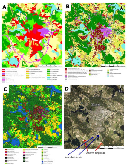
Figure 3.
Land-use/land-cover maps generated based on the following: (A) CORINE Land Cover; (B) Urban Atlas; (C) Database of Topographic Objects (DBTO10k); (D) orthophoto map data. Note that the legend describes only land-use/land-cover types that have been identified in the studied area.
Significant differences in land-use structure were observed among the examined databases. The DBTO10k (Figure 3C) contains the most detailed information. This database lists the highest number of land-use types, and the presented spatial data are most detailed and accurate. These data are suitable for conducting detailed analyses of land-use structure. The Urban Atlas (Figure 3B) also features highly accurate data, but its level of detail is lower than that of DBTO10k. The CORINE Land Cover (Figure 3A) is characterized by the lowest level of detail and a very high degree of generalization. The most striking differences in land-use structure were observed in areas with a residential function. When the CLC data were considered in the analysis, a very large fragment of the analyzed city was covered by continuous and discontinuous urban fabric. In turn, the Urban Atlas identifies five urban land-use types that differ in development density, whereas the DBTO10k lists two categories (apartment buildings and single-family homes) and is characterized by the highest level of detail as compared with the remaining databases. An evaluation of suburban zones also revealed certain differences among the compared databases. The CLC contains highly generalized data that cannot be used in analyses of suburbanization and urban sprawl. The Urban Atlas and the DBTO10k feature more detailed data and are more suited for such evaluations.
Considerable differences in data validity were noted between the DBTO10k and the remaining databases. The orthophoto map (Figure 3D) presenting the Olsztyn ring road (built in 2018–2019) indicates that the DBTO10k inventory contains least up-to-date information. The Olsztyn ring road is completely absent in the maps developed based on DBTO10k data (last update in 2015), and it is displayed as a construction site in the remaining maps. Therefore, despite the fact that the DBTO10k is characterized by the most detailed data, the presented information is most outdated and does not account for the recently developed ring road. Taking into account the suburban areas indicated on the orthophoto map (Figure 3D), the DBTO10k contains the least up-to-date information, the CORINE Land Cover is the most generalized (only one land-use type, i.e., discontinuous urban fabric). The Urban Atlas identifies fourteen land-use types (ten urban land-use types) and is characterized by the highest level of detail as compared with the remaining databases.
It should be noted that a high number of land-use/land-cover types in a classification system does not imply that the rendered large-scale maps will contain highly detailed information. Eighteen of the 44 land-use types listed in the CLC were identified in the studied area. A much smaller difference was noted in the maps rendered based on Urban Atlas and DBTO10k data. Twenty-nine of the 35 land-use types covered by the DBTO10k were visualized, and 21 of the 27 land-use types listed in the Urban Atlas were identified in the test area.
All analyzed databases are available through WMS services. Importantly, the CLC and the Urban Atlas data are available for users in raster and vector version, whereas DBTO10k resources are available in vector version (GML file format). In the latter case (vector version), the map can be modified, i.e., the colors denoting various land-use types can be modified; layers can be added, removed or separated; and data from different levels (first, second, and third) can be extracted.
4. Discussion
The present study was aimed at generating information about the existing land use classifications and spatial databases and discussing their strengths, weaknesses, and limitations. Despite a high number of land-use types, the availability of public databases and WMS services, and the option of directly importing data in GIS software, the information acquired from the existing databases has certain limitations. These weaknesses should be identified to ensure that the optimal source of data is selected for land-use/land-cover analyses.
The first limitation is the low level of detail. The CORINE Land Cover data are far less detailed than the information available in the DBTO10k, the Polish cadaster, and the Urban Atlas. The CLC contains highly generalized data that may not be suitable for research purposes or for analyzing various areas at a scale of 1:1000 or higher, including city districts, cities, and suburban zones where highly detailed information is needed. The CLC is not appropriate for examining small and fragmented areas because the relevant data are highly generalized [53,54]. However, CLC data are widely available and easy to acquire, and they can be applied in small-scale analyses where a high level of detail is not required. The DBTO10k is characterized by the most detailed data which, however, are limited to the territory of Poland.
The second limitation is the low availability of data. Maps based on CLC data are developed individually in each country, but the applicability of the CLC inventory for analyzing land-use structure in various countries is debatable [21]. The Urban Atlas covers only FUAs in most European countries; therefore, its applicability is limited. The DBTO10k was only placed in the public domain in 2020 [52], but the validity of data covering Polish regions varies, which prevents effective comparisons. The Polish cadaster contains the most valid data. The main limitation of cadastral data is that they can be applied only in countries where the cadaster is common and fully available. Cadastral databases are being developed in numerous countries, but they are not fully available in other states [55].
The third limitation is the validity of data. The examined databases are updated at different time intervals, and they cannot be adapted to current research needs. For example, the DBTO10k contains data that were collected and updated between 2013 and 2020, and their validity differs across Polish regions. In turn, the CLC and the Urban Atlas were last updated in 2018. Therefore, when selecting a data source for land management analyses, researchers should keep in mind that the chosen repository may not be fully up to date and that the current land-use status of the examined area may differ from that presented in the available databases.
Fourthly, not all databases fully cover the examined area. The above applies particularly to the Urban Atlas which focuses on FUAs. Data display and data entry errors can also be encountered in some systems.
Lastly, the compared classification systems differ considerably in the number of land-use types. However, the number of land-use types is not directly correlated with the accuracy and level of detail in the generated maps. It should also be noted the land-use types identified in various classification systems may not be fully compatible even if those systems deploy identical or similar nomenclature [15].
Discrepancies and errors resulting from differences in input data and map generation methods can also be encountered in land use classification systems, which is an additional disadvantage [25,56]. The above problem applies to satellite data, and also to cadasters and national databases such as the Database of Topographic Objects. Systems that rely on remotely sensed data provide information about land use/land cover and support the generation of less detailed maps on a smaller scale.
Informal classification systems that are developed for specific research needs or are based on the existing formal systems are used in thematic analyses. As a result, these systems can be tainted by subjectivity. In land use classification systems that are not cross referenced with spatial databases, maps have to be generated from scratch based on spatial inventories, mobile phone data, and other sources. These procedures are highly time consuming. The information available in public databases can also be modified for the needs of informal classification systems.
Due to the multiplicity of land use/land cover classification systems and sources of data, the resulting information can be difficult to interpret because the land-use structure of a given region can differ depending on the adopted classification system or data source [20]. Areas situated in different countries or regions can also be difficult to compare. Despite certain similarities in land-use/land -over types, the functional classification of land-use types can differ across systems that rely on various sources of spatial data. Data repositories also differ in the level of detail, data validity, and accessibility. Therefore, the diversity of classification systems, perspectives, classification methods and data collection methods, limited territorial cover, and differences in data validity pose a significant problem [15]. The selection and the use of databases depends on the type of conducted research, their aims and scope, research area, as well as assumptions regarding the validity, availability, applicability, and accuracy of data. Each of the land-use/land-cover sources can be used independently. Regardless of the selected database and the availability of spatial features, the strengths and weaknesses as well as the accuracy, precision, level of detail (generalization) and reliability of every data source, should always be taken into consideration.
5. Conclusions
Land-use/land-cover data were examined in selected land use classification systems, and the influence of classification systems linked spatial databases on the quality and feasibility of land management analyses was evaluated. The existing databases and their strengths, weaknesses, and limitations were described. Land use/land cover classification systems that are directly linked with spatial databases were identified for the purpose of automating the analytical process, for example, with the use of GIS software. The results of the study validated the research hypothesis postulating that the existing classification systems and spatial databases differ considerably in the level of detail, validity, and availability of data, as well as the number of categories of land use/land cover. It can be concluded that different classification systems contain information with varying levels of detail. Most classification systems have been placed in the public domain, and data repositories that are best suited for the generation of maps with the required spatial resolution can be selected online at no additional charge. The study confirmed that classification systems that are cross referenced with spatial databases contain a greater number of land-use types than informal classifications that are developed for specific research needs, including thematic scientific analyses. The study also revealed that a high number of land-use types does not always imply that the offered data are highly detailed. Therefore, classification systems and land-use types should always be selected based on the level of detail that is appropriate for specific analytical purposes. The limitations of the existing databases, including incomplete coverage of the studied area, invalid data, limited availability, level of detail (generalization), differences in nomenclature, and the number of identified land-use types, should also be taken into account. Regardless of the selected database and the availability of spatial features, the strengths and weaknesses, as well as the accuracy, precision, and reliability of every data source should always be taken into consideration.
The current status and ongoing changes in land management should be regularly monitored in urbanized areas and areas subjected to anthropogenic pressure to counteract the negative effects of urbanization. Typical analyses of land-use structure are generally conducted with the use of spatial data that are widely available in raster or vector version. The existing sources of satellite data, including the CLC database, are characterized by a lower level of detail and a high degree of generalization, and they may not be suitable for land-use analyses of large-scale areas (such as small- and medium-sized towns, districts, and suburbs).
Author Contributions
P.S.-I., Conceptualization, methodology, validation, formal analysis, investigation, resources, data curation, writing—original draft preparation, writing—review and editing, visualization, supervision. The author has read and agreed to the published version of the manuscript.
Funding
This research received no external funding.
Institutional Review Board Statement
Not applicable.
Informed Consent Statement
Not applicable.
Data Availability Statement
Publicly available datasets were analyzed in this study. This data can be found here: https://atlas.warmia.mazury.pl/ (accessed on 10 December 2020), https://land.copernicus.eu/pan-european/corine-land-cover (accessed on 18 December 2020), https://land.copernicus.eu/local/urban-atlas (accessed on 20 December 2020), and https://bdl.stat.gov.pl (accessed on 16 December 2020)].
Conflicts of Interest
The author declare no conflict of interest.
References
- Riad, P.; Graefe, S.; Hussein, H.; Buerkert, A. Landscape transformation processes in two large and two small cities in Egypt and Jordan over the last five decades using remote sensing data. Landsc. Urban Plan. 2020, 197, 103766. [Google Scholar] [CrossRef]
- Senetra, A.; Szarek-Iwaniuk, P. Land use changes in urbanized areas located in the cities of the lake district—Ostróda residential areas case study. Eur. Plan. Stud. 2019, 28, 809–829. [Google Scholar] [CrossRef]
- Dewan, A.M.; Yamaguchi, Y. Land use and land cover change in Greater Dhaka, Bangladesh: Using remote sensing to promote sustainable urbanization. Appl. Geogr. 2009, 29, 390–401. [Google Scholar] [CrossRef]
- Benini, L.; Bandini, V.; Marazza, D.; Contin, A. Assessment of land use changes through an indicator-based approach: A case study from the Lamone river basin in Northern Italy. Ecol. Indic. 2010, 10, 4–14. [Google Scholar] [CrossRef]
- Reid, R.S.; Kruska, R.L.; Muthui, N.; Taye, A.; Wotton, S.; Wilson, C.J.; Mulatu, W. Land-use and land-cover dynamics in response to changes in climatic, biological and socio-political forces: The case of southwestern Ethiopia. Landsc. Ecol. 2000, 15, 339–355. [Google Scholar] [CrossRef]
- Rodrigo-Ilarri, J.; Romero, C.P.; Rodrigo-Clavero, M.E. Land Use/Land Cover Assessment over Time Using a New Weighted Environmental Index (WEI) Based on an Object-Oriented Model and GIS Data. Sustainability 2020, 12, 234. [Google Scholar] [CrossRef]
- Briassoulis, H. Factors influencing land-use and land-cover change. In Land-Use, Land-Cover and Soli Sciences. Encyclopaedia of Life Support System; Eolss Publishers: Oxford, UK, 2009; Volume 1, pp. 126–146. [Google Scholar]
- Verburg, P.H.; Ritsema van Eck, J.R.; Nijs, T.C.M.; Dijst, M.J.; Schot, P. Determinants of land-use change patterns in the Netherlands. Environ. Plan. B Plan. Des. 2004, 31, 125–150. [Google Scholar] [CrossRef]
- Słodczyk, J. Przestrzeń Miasta i Jej Przeobrażenia [Urban Space and Its transformations]; Wydawnictwo Uniwersytetu Opolskiego: Opole, Poland, 2001; p. 304. [Google Scholar]
- Niedziałkowski, K.; Beunen, R. The risky business of planning reform–the evolution of local spatial planning in Poland. Land Use Policy 2019, 85, 11–20. [Google Scholar] [CrossRef]
- Solly, A.; Berisha, E.; Cotella, G.; Janin Rivolin, U. How Sustainable Are Land Use Tools? A Europe-Wide Typological Investigation. Sustainability 2020, 12, 1257. [Google Scholar] [CrossRef]
- United Nations. Land and Sustainable Development Goals. 2018. Available online: https://www.unccd.int/issues/land-and-sustainable-development-goals (accessed on 22 December 2020).
- Durán, Z.V.H.; Rodríguez, P.C.R.; Flanagan, D.C.; García, T.I.; Muriel, F.J.L. Sustainable land use and agricultural soil. In Alternative Farming Systems, Biotechnology, Drought Stress and Ecological Fertilisation. Sustainable Agriculture Reviews 6; Lichtfouse, E., Ed.; Springer Science + Business Media BV: Amsterdam, Netherlands, 2011; pp. 107–192. [Google Scholar] [CrossRef]
- Li, X.; Yeh, A.G. Analyzing spatial restructuring of land use patterns in a fast growing region using remote sensing and GIS. Landsc. Urban Plan. 2004, 69, 335–354. [Google Scholar] [CrossRef]
- Anderson, A.; Hardy, E.; Roach, J.; Witmer, R. A land use and land cover classification system for use with remote sensor data. Geol. Surv. Prof. Pap. 1976, 964. [Google Scholar] [CrossRef]
- Hu, S.; Wang, L. Automated urban land-use classification with remote sensing. Int. J. Remote Sens. 2013, 34, 790–803. [Google Scholar] [CrossRef]
- Harris, P.M.; Ventura, S.J. The integration of geographic data with remotely sensed imagery to improve classification in an urban area. Photogramm. Eng. Remote Sens. 1995, 61, 993–998. [Google Scholar]
- Pei, T.; Sobolevsky, S.; Ratti, C.; Shaw, S.-L.; Zhou, C. A New Insight into Land Use Classification Based on Aggregated Mobile Phone Data. Int. J. Geogr. Inf. Sci. 2013, 28, 1988–2007. [Google Scholar] [CrossRef]
- Kasenko, M.; Barredo, I.J.; Lavalle, C.; McCormick, N.; Demicheli, L.; Sagris, V.; Brezger, A. Are European cities becoming dispersed? A comparative analysis of 15 European urban areas. Landsc. Urban Plan. 2006, 77, 111–130. [Google Scholar] [CrossRef]
- Bach, M.; Breuer, L.; Frede, H.G.; Huisman, J.; Otte, A.; Waldhardt, R. Accuracy and congruency of three different digital land-use maps. Landsc. Urban Plan. 2006, 78, 289–299. [Google Scholar] [CrossRef]
- Cegielska, K.; Noszczyk, T.; Kukulska, A.; Szylar, M.; Hernik, J.; Dixon-Gough, R.; Jombach, S.; Valanszki, I.; Kovacs, K. Land use and land cover changes in post-socialist countries: Some observations from Hungary and Poland. Land Use Policy 2018, 78, 1–18. [Google Scholar] [CrossRef]
- Patra, S.; Sahoo, S.; Mishra, P.; Mahapatra, S.C. Impacts of urbanization on land use/cover changes and its probable implications on local climate and groundwater level. J. Urban Manag. 2018, 7, 70–84. [Google Scholar] [CrossRef]
- Liu, T.; Yang, X. Monitoring land changes in an urban area using satellite imagery, GIS and landscape metrics. Appl. Geogr. 2015, 56, 42–54. [Google Scholar] [CrossRef]
- Petrişor, A.; Ianoş, I.; Tălângă, C. Land cover and use changes focused on the urbanization processes in Romania. Environ. Eng. Manag. J. 2010, 9, 765–771. [Google Scholar] [CrossRef]
- Díaz-Pacheco, J.; Gutiérrez, J. Exploring the limitations of CORINE Land Cover for monitoring urban land-use dynamics in metropolitan areas. J. Land Use Sci. 2013, 9, 243–259. [Google Scholar] [CrossRef]
- Mohajane, M.; Essahlaoui, A.; Oudija, F.; Hafyani, M.E.; Hmaidi, A.E.; Ouali, A.E.; Randazzo, G.; Teodoro, A.C. Land Use/Land Cover (LULC) Using Landsat Data Series (MSS, TM, ETM+ and OLI) in Azrou Forest, in the Central Middle Atlas of Morocco. Environments 2018, 5, 131. [Google Scholar] [CrossRef]
- Jia, Y.; Ge, Y.; Ling, F.; Guo, X.; Wang, J.; Wang, L.; Chen, Y.; Li, X. Urban Land Use Mapping by Combining Remote Sensing Imagery and Mobile Phone Positioning Data. Remote Sens. 2018, 10, 446. [Google Scholar] [CrossRef]
- Lenormand, M.; Picornell, M.; Cantú-Ros, O.G.; Louail, T.; Herranz, R.; Barthelemy, M.; Frías-Martínez, E.; San, M.M.; Ramasco, J.J. Comparing and modelling land use organization in cities. R. Soc. Open Sci. 2015, 2, 1–11. [Google Scholar] [CrossRef]
- Wang, Y.; Wang, T.; Tsou, M.-H.; Li, H.; Jiang, W.; Guo, F. Mapping dynamic urban land use patterns with crowdsourced geo-tagged social media (Sina-Weibo) and commercial points of interest collections in Beijing, China. Sustainability 2016, 8, 1202. [Google Scholar] [CrossRef]
- Cheng, J.; Masser, I. Urban growth pattern modeling: A case study of Wuhan City, PR China. Landsc. Urban Plan. 2003, 62, 199–217. [Google Scholar] [CrossRef]
- Jat, M.K.; Garg, P.K.; Khare, D. Monitoring and modelling of urban sprawl using remote sensing and GIS techniques. Int. J. Appl. Earth Obs. Geoinf. 2008, 10, 26–43. [Google Scholar] [CrossRef]
- Chen, L. Redefining the Typology of Land Use in the Age of Big Data. Ph.D. Thesis, Massachusetts Institute of Technology, Cambridge, MA, USA, 2014. [Google Scholar]
- Copernicus. Available online: https://land.copernicus.eu/ (accessed on 28 December 2020).
- Pazúr, R.; Feranec, J.; Štych, P.; Kopecká, M.; Holman, L. Changes of Urbanised Landscape Identified and Assessed by the Urban Atlas Data: Case Study of Prague and Bratislava. Land Use Policy 2017, 61, 135–146. [Google Scholar] [CrossRef]
- Petrișor, A.I. Assessment of green infrastructure of Bucharest using CORINE and Urban Atlas data. Urban. Archit. Constr. 2015, 6, 19–24. [Google Scholar]
- Prastacos, P.; Chrysoulakis, N.; Kochilakis, G. Spatial metrics for Greek cities using land cover information from the Urban Atlas. In Multidisciplinary Research on Geographical Information in Europe and Beyond, Proceedings of the AGILE’2012 International Conference on Geographic Information Science, Avignon, France, 24–27 April 2012; Gensel, J., Josselin, D., Vandenbroucke, D., Eds.; Springer: Berlin, Germany, 2012; pp. 261–266. [Google Scholar]
- Barranco, R.R.; Silva, F.B.E.; Marin Herrera, M.; Lavalle, C. Integrating the MOLAND and the Urban Atlas Geo-databases to Analyze Urban Growth in European Cities. J. Map Geogr. Libr. 2014, 10, 305–328. [Google Scholar] [CrossRef]
- Bičík, I.; Jeleček, L. Land use and landscape changes in Czechia during the period of transformation 1990–2007. Geografie 2009, 114, 263–281. [Google Scholar] [CrossRef]
- Jansen, L.; Carrai, G.; Petri, M. Land-use change at cadastral parcel level in Albania. Model. Land Use Chang. 2007, 90, 25–44. [Google Scholar]
- Micek, O.; Feranec, J.; Stych, P. Land Use/Land Cover Data of the Urban Atlas and the Cadastre of Real Estate: An Evaluation Study in the Prague Metropolitan Region. Land 2020, 9, 153. [Google Scholar] [CrossRef]
- Regulation of the Minister of the Interior and Administration of 17 November 2011 on the database of topographic objects, the database of geographic and spatial objects, and standard maps with attachments. Journal of Laws, 2011.279.1642.
- Regulation of the Minister of Regional Development and Construction of 29 March 2001 on Land and Buildings Register. Journal of Laws, 2019.393.
- Pérez-Hoyos, A.; García-Haro, F.J.; San-Miguel-Ayanz, J. Conventional and fuzzy comparisons of large scale land cover products: Application to CORINE, GLC2000, MODIS and GlobCover in Europe. ISPRS J.Photogramm. Remote Sens. 2012, 74, 185–201. [Google Scholar] [CrossRef]
- Huang, Z.; Qi, H.; Kang, C.; Su, Y.; Liu, Y. An Ensemble Learning Approach for Urban Land Use Mapping Based on Remote Sensing Imagery and Social Sensing Data. Remote Sens. 2020, 12, 3254. [Google Scholar] [CrossRef]
- CORINE. CORINE Land Cover. 2019. Available online: https://land.copernicus.eu/pan-european/corine-land-cover (accessed on 18 December 2020).
- Urban Atlas. 2020. Available online: https://land.copernicus.eu/local/urban-atlas (accessed on 20 December 2020).
- Central Statistical Office. 2020. Available online: https://bdl.stat.gov.pl (accessed on 16 December 2020).
- Onur, I.; Maktav, D.; Sari, M.; Sonmez, N.K. Change detection of land cover and land use using remote sensing and GIS: A case study in Kemer, Turkey. Int. J. Remote Sens. 2009, 30, 1749–1757. [Google Scholar] [CrossRef]
- CORINE Land Cover Nomenclature. 2019. Available online: https://land.copernicus.eu/user-corner/technical-library/corine-land-cover-nomenclature-guidelines/html (accessed on 18 December 2020).
- Dawidowicz, A.; Źróbek, R. A methodological evaluation of the Polish cadastral system based on the global cadastral model. Land Use Policy 2018, 73, 59–72. [Google Scholar] [CrossRef]
- Harvey, F. The power of mapping: Considering discrepancies of Polish cadastral mapping. Ann. Assoc. Am. Geogr. 2013, 103, 824–843. [Google Scholar] [CrossRef]
- Act of 16 April 2020 amending the Geodetic and Cartographic Law and some other acts. Journal of Laws, 2020.782.
- Cole, B.; Smith, G.; Balzter, H. Acceleration and fragmentation of CORINE land cover changes in the United Kingdom from 2006–2012 detected by Copernicus IMAGE2012 satellite data. Int. J. Appl. Earth Obs. Geoinf. 2018, 73, 107–122. [Google Scholar] [CrossRef]
- Śleszyński, P.; Gibas, P.; Sudra, P. The Problem of Mismatch between the CORINE Land Cover Data Classification and the Development of Settlement in Poland. Remote Sens. 2020, 12, 2253. [Google Scholar] [CrossRef]
- Williamson, I.; Enemark, S.; Wallace, J.; Rajabifard, A. Land Administration for Sustainable Development; ESRI Press Academic: Redlands, CA, USA, 2010. [Google Scholar]
- García-Álvarez, D.; Camacho Olmedo, M.T. Changes in the methodology used in the production of the Spanish CORINE: Uncertainty analysis of the new maps. Int. J. Appl. Earth Obs. Geoinf. 2017, 63, 55–67. [Google Scholar] [CrossRef]


Publisher’s Note: MDPI stays neutral with regard to jurisdictional claims in published maps and institutional affiliations. |
© 2021 by the author. Licensee MDPI, Basel, Switzerland. This article is an open access article distributed under the terms and conditions of the Creative Commons Attribution (CC BY) license (http://creativecommons.org/licenses/by/4.0/).