Article

Conflicts over Land as a Risk for Social-Ecological Resilience: A Transnational Comparative Analysis in the Southwestern Amazon

by
Rebecca Froese
1,2,*,
Claudia Pinzón
3,
Loreto Aceitón
4,
Tarik Argentim
5,
Marliz Arteaga
6,7,
Juan Sebastian Navas-Guzmán
8,
Gleiciane Pismel
9,
Sophia Florence Scherer
10,
Jannis Reutter
1,
Janpeter Schilling
1,2 and
Regine Schönenberg
3
1
Institute of Environmental Sciences, University of Koblenz-Landau, Fortstraße 7, 76829 Landau, Germany
2
Peace Academy Rhineland-Palatinate, University of Koblenz-Landau, 76829 Landau, Germany
3
Institute for Latin American Studies, Free University Berlin, 14197 Berlin, Germany
4
Faculty of Engineering, Metropolitan University of Technology, Santiago 8320000, Chile
5
National Institute for Amazonian Research, Manaus 69067-375, Brazil
6
Faculty of Biological and Natural Sciences, Amazonian University of Pando, Cobija 69932-000, Bolivia
7
School of Natural Resources and Environment, University of Florida, Gainesville, FL 32603, USA
8
Faculty of Human Sciences and Economics, National University of Colombia, Medellín 5003, Colombia
9
Center for Philosophy and Social Sciences, Federal University of Acre, Rio Branco 69917-400, Brazil
10
Center for Development Research, University of Bonn, 53113 Bonn, Germany
*
Author to whom correspondence should be addressed.
Sustainability 2022, 14(11), 6520; https://doi.org/10.3390/su14116520
Submission received: 4 April 2022 / Revised: 22 May 2022 / Accepted: 24 May 2022 / Published: 26 May 2022
(This article belongs to the Section Social Ecology and Sustainability)

Abstract

:
People in the department of Madre de Dios/Peru, the state of Acre/Brazil, and the department of Pando/Bolivia experience similar conflicts over land, land use, and access to resources. At the same time, each conflict reveals distinct characteristics and dynamics, arising from its history, legal regulation, institutional (in-)capacities, and culturally diverse local populations. The aim of this paper is to better understand the main drivers of social-ecological conflicts over land in and around three protected areas in this transboundary region, known as MAP, and to analyze how (environmental) institutions influence these drivers. The paper is based on a literature review and expert interviews; it focuses on conflicts around (1) gold mining in Madre de Dios, (2) extensive cattle ranching in Acre, and (3) access to communal land in Pando. Using theories of conflict research, expanded by a political ecology perspective and insights from stakeholder and expert interviews, we find that the major conflict drivers are (1) land tenure and access to land and natural resources, (2) identity and lifestyle driven transformations, (3) state and market driven agendas, and (4) networked illegal and criminal activities. Through a comparative conflict analysis, we develop four recommendations to strengthen the creation of reflexive institutions that may be able to foster social-ecological resilience in the region: (1) The clarification of responsibilities between governance institutions and their financing; (2) the awareness raising for existing power structures and opening spaces for enhanced local participation; (3) the breaking of corruptive cycles while developing economically, ecologically, and socially sustainable livelihood opportunities; and (4) taking the continuous reproduction of illegal activities into account while clarifying responsibilities, raising awareness, and breaking corruptive cycles. The results of our research therefore not only contribute to a better understanding of conflicts in the MAP region and the wider scientific literature on social-ecological conflicts and governance, but it is also the first paper that identifies entry points and prerequisites for the transformation from reactive to reflexive institutions in Amazonian societies.

1. Introduction

Access to and control over natural resources play a key role in land use conflicts in the southwestern Amazon [1]. Often, formal and informal institutions govern access and distribution of natural resources, and thus directly or indirectly shape and influence the conflict potential in the region [2]. While these institutions have undergone many restructuring processes through sometimes fast changing governmental frame conditions throughout the past century, underlying structures have mostly remained centralized. These centralized structures were manifested through processes of colonial continuities that often resulted in deadlocked institutional stability during mostly stable environmental conditions of the Holocene. We would like to highlight here that ‘stability’ is not necessarily understood positively, such as contributing to human well-being. Rather, stability of the current state can also be an indicator of unjust or inadequate dynamics. In combination, these global stable conditions resulted in more or less stable social-ecological systems (SES) [3], although regional SES were highly threatened through colonial and neo-colonial practices, e.g., [4,5,6].
The erosion of this social-ecological stability through increasing human interference with the Earth System during the Anthropocene deprives the foundations of these formerly stable structures. Consequently, arising governance challenges call for the dynamic transformation of institutions on comparatively short timescales. We understand governance here alongside Arguedas [7] and Saunier and Meganck [8] as the process by which the state, non-state institutions, and civil society interact to make decisions, formulate and implement policies, exercise agency, and pursue other types of actions in the common interest. In the literature, the required institutional transformation is referred to as the development of reflexivity within institutions [6]. Reflexivity can be created through adaptive management processes fostering proactive agency instead of mere reactive management of change, or as Dryzek [9] puts it “being or becoming” a different institution rather than simply “doing” something different. This process requires the development of new reflexive governance competencies as it has been argued by McKay et al. [10] who developed a diagnostic tool to measure them. Such reflexive competencies enable institutions to react dynamically and iteratively to changing conditions and hence are one condition for the creation of resilient institutions.
At the tri-national Amazonian border of Madre de Dios/Peru, Acre/Brazil, and Pando/Bolivia—also known as the MAP region—the neighboring geographic spaces share similar ecological characteristics. However, their social, economic, and historical properties are very different [11]. The MAP region contains large areas of primary forest often under unclear land tenure systems, facing at the same time increasing pressure through extending agricultural, mining, and infrastructural developments. These activities are sometimes well connected to activities of organized crime [12]. The three subnational entities share the occurrence of conflicts over land use and access to resources in and around protected areas (PA); however, the distinctiveness of each conflict arises from both the evolution of governance institutions and the different socio-cultural systems in each country. Little is known about this interplay of governance from formal and informal (environmental) institutions within differing social-cultural environments and their impact on social-ecological conflicts over land in the MAP region. Therefore, this paper aims to answer the question: What are the main drivers of social-ecological conflicts over land in and around three protected areas in the MAP region and how do (environmental) institutions influence these drivers? Addressing this question is important because land use conflicts, potentially developing into violent ones, have a greater impact on people who depend on land to secure their livelihoods [13]. Therefore, understanding environmental governance is important in preventing and mitigating conflicts and is thus highly relevant for people’s and nature’s well-being. This paper therefore not only contributes to a better understanding of conflicts in the MAP region and the wider scientific literature on social-ecological conflicts and governance, it is also the first paper that identifies entry points for the transformation from reactive to reflexive institutions which can strengthen the resilience of rural and disadvantaged population in Amazonian societies. Approaching social resilience from a conflict perspective is a special case, as conflicts and how they are dealt with can be seen as both a challenge for and measure of social resilience. By focusing on conflicts related to land and the environment, we draw the connection between social and ecological resilience and thus follow the demands formulated by During et al. [14] to contribute to the distinct knowledge on social resilience, that is relevant for re-relating people and nature.
We embed our conflict analysis within a social-ecological perspective to account for the deeply intertwined human-nature relationships in the MAP region and the corresponding impossibility to separate the conflict analysis from SES dynamics. Consequently, we use the term social-ecological conflicts, see also [15]. Particularly, we focus on three conflicts over land use in and around PAs, one in each sub-national entity: (1) illegal gold mining in Madre de Dios, (2) extensive cattle ranching in Acre, and (3) access to communal land in Pando.
The article is structured into four sections: In Section 2, we introduce the research region and our analytical framework and describe our methods. In Section 3, we present our results starting with an overview of institutional governance structures of the respective PAs followed by a contextualization of these dynamics and their tensions with prevalent organized crime. Section 3 continues with the comparative analysis of the social-ecological conflicts over land use along four major conflict drivers. In Section 4, we discuss those conflict drivers and how they are affected by formal, informal and illegal institutions. Section 4 closes with a summary on the contribution of our research on understanding conflict drivers in the MAP region and the lessons learnt for the design of reflexive institutions.

2. Materials and Methods

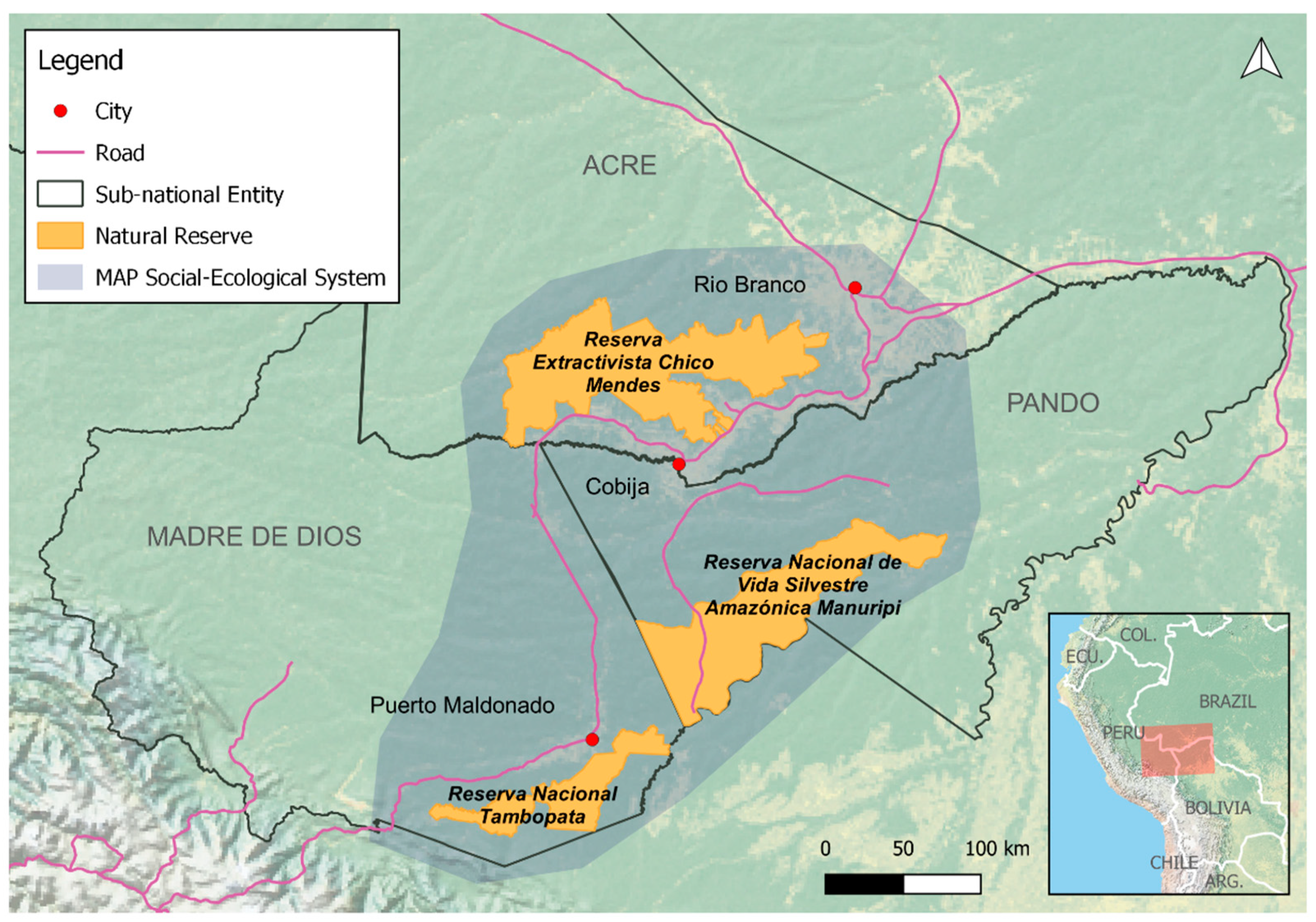
2.1. The Research Region

Our research region is located in the southwestern Amazon (see Figure 1). The transboundary MAP region has a high social, environmental, and economic diversity and is characterized by an abundant biodiversity, including large parts of primary forest, an advancing agricultural frontier, difficult accessibility, and consequently a scarce state presence [16,17]. Currently, the extraction of non-timber forest products (NTFP), such as Brazil nuts, açaí, and to a lesser degree also rubber, is a major formal economic activity in the MAP region and the most important regional labor market.
For many years, the remoteness of the MAP region and its lack of infrastructure kept the region’s resource richness and species diversity at stable levels providing livelihoods for indigenous and traditional communities. Nevertheless, since the 1960s, an improved road infrastructure made previously inaccessible areas accessible, leading to immigration from neighboring departments/states and the expansion of agricultural activities, local trade, and increased natural resource extraction [18]. Hence, over the last decades, the MAP region has been facing drastic transformations in land use patterns, which have had repercussions on biodiversity management and access to natural resources, in particular on NTFP: On the one hand, environmental conservation zones have been consolidated and are being managed by indigenous and extractivist populations as well as (non-)governmental agencies, with each actor assuming different responsibilities [19]. On the other hand, illegal timber and mineral exploitation and increasing cattle ranching are activities that define the landscape and represent a challenge for conservation measures, local populations, and regional governance [20]. In addition to these land use changes, the effects of regional climate change, such as a prolonged dry-season length and increased drought frequency, threaten the resilience of the regional ecosystem [21]. Together with larger-scale regional development plans, these changes impose risks to the resilience of the MAP social-ecological system [22].
For the land-use conflict analysis in this article, we compare three PAs and their buffer zones within the MAP social-ecological system: The Tambopata National Reserve in Madre de Dios, the Chico Mendes Extractivist Reserve in Acre, and the Manuripi National Amazonian Wildlife Reserve in Pando.
The Tambopata National Reserve is located south of the Madre de Dios River in Madre de Dios. It covers an area of 278,284 hectares, surrounded by a buffer zone of 186,450 hectares (INRENA, 2003). The PA was designated in 2000 by Supreme Decree No. 048-2000-AG with the objective to protect the wild flora and fauna, conserve natural and cultural resources, and investigate the potential use of natural resources. This aimed at facilitating the participation of neighboring populations in the management of these resources and promoting the sustainable use of Brazil nut trees (DS N° 012-96 AG) [23]. However, the resilience of the ecosystem and the population that depends on its natural resources are threatened by illegal gold mining and drug trafficking [24].
The Chico Mendes Extractivist Reserve (Sustainable Use Conservation Unit), in the following referred to as ResEx Chico Mendes, is located in the state of Acre, and covers an area of 931,537 hectares, including seven municipalities and a population of almost 2000 families. The reserve belongs to the PA category of Extractivist Reserves, which are territorial administrative spaces that aim to guarantee the sustainable use of natural resources and protect the livelihoods and cultural lifestyles of the traditional forest peoples (Plano de Manejo da Reserva Extractivista Chico Mendes) [25]. It was created in 1990 and named after Francisco ‘Chico’ Mendes, a trade union leader and rubber tapper who stood up for the rights of the traditional communities in the reserve and was assassinated in 1988 by large landowners. At that time, these landowners represented the wish for land use change towards large farms/properties, which is still one of the major reasons for land conflicts in the region [26].
The Manuripi National Amazonian Wildlife Reserve is located in the Manuripi province in the west of the department Pando, covering an area of approximately 747,000 hectares. Its main objective is to protect the Amazon rainforest ecosystem, watersheds, flora and fauna species, and to promote the integral and sustainable use of forest resources to improve the lives of the local population (Plan de Manejo de la Reserva Nacional de Vida Silvestre Manuripi 2012–2022) [27]. The reserve was created in 1973 and is home to ten communities with approximately 1700 inhabitants. The livelihoods are based on small-scale agricultural and livestock activities, subsistence hunting and fishing, as well as açaí and Brazil nut extraction, among other NTFPs [27].

2.2. Analytical Framework

The overall aim of this research is to better understand social-ecological conflicts in the research region. Hence, social-ecological conflicts are considered the causal phenomena in our analytical framework (see Figure 2). Following Scheffran et al. [28], we understand conflicts as social processes involving at least two parties (individuals, groups, state actors, etc.) acting according to diverging interests over a conflict item. Unequal actor constellations and imbalanced power structures among the conflict parties as well as their capacities to use the social structures impact the agency of conflict actors and thus increase the potential for asymmetry within the conflict [29]. Power in relation to power imbalances is understood here as an actor-specific resource that we approached in its relation to societal change, following Avelino and Rotmans [30]. In this sense, power relations are crucial in long-term processes of structural change and thus essential for the creation of reflexive governance capabilities within and across institutional structures.
Social-ecological conflicts are the causal phenomena resulting from the interplay of conflict drivers (independent variable), the intensity of land use (dependent variable), and the reflexivity of institutions (intervening variable). Taking into consideration the social and spatial aspects of the conflicts, we were able to identify the first drivers of conflicts through the literature review. The interviews conducted further helped us fill in the gaps where institutions have the capacity to act, in order to guarantee the equal or regulated access to natural resources in the three PAs. As a result, we identified the following four main drivers in the MAP region: (1) land tenure and access to land and natural resources, (2) identity and lifestyle driven transformations, (3) state and market driven agendas, and (4) networked illegal and criminal activities. These drivers are strongly impacting the intensity of land use and people’s access to natural resources. Formal institutions intervene in this relationship with the implementation of governance measures. Depending on their capabilities, these institutions act in either reactive or reflexive manner. At the same time, informal and illegal institutions intervene, empowered by a lack of law enforcement, impunity, and alternative governance structures at the margin of the state. These informal and illegal institutions often demonstrate a higher degree of reflexivity than the (negatively) stable formal institutions. Here, we particularly consider national and transnational organized crime structures as the underbelly of the reflexivity of institutions. The criminal cycle (orange) and its interfaces with relevant elements of the SES (gray) are considered as antecedent and catalytic conditions for conflict drivers, the reflexivity of institutions, and the intensity of land use.
With land in and around PAs being the conflict item, we find it particularly useful to follow Rechciński et al. [15], and combine two aspects of conflict analysis which are often addressed separately: the spatial and the social-relational aspects. The spatial aspect of conflict analysis is particularly relevant since conservation measures, such as declaring an area as protected territory, are always related to space and have an impact on social actors connected to those spaces. This aspect is addressed by defining the boundaries of the social-ecological system (see Figure 1) and conducting the conflict analysis within these boundaries. We problematize the fact that both PAs and governmental institutions in the MAP region are located far away from the political centers of the three states, which can have implications in the regional governance. According to [31], space can be theoretically organized in center and periphery, reflecting a hierarchization of space and, above all, identifying the power structures connecting these spaces. In this sense, we recognize that there are power relations that permeate geographical spaces. Therefore, we propose to distinguish between the following concepts: states and regions. According to van Langenhove [32], a region is a geographical space that cannot be called a state and yet to some extent has the characteristics of a state. This means that a region can have an own political agenda and an institutional structure that is linked to the central state in two ways: as a support, but sometimes also with a tendency to distance itself from it [32], though always embedded in the structures of the central state [33]. The social-relational component is addressed by taking a political ecology perspective focusing on the actors’ interests and networks as well as inequality and political dynamics on and across different scales [2]. These scales are prevalent in our framework within the identified conflict drivers and intervening institutions (see Figure 3).
Political ecology recognizes the relationships between humans and the environment, and facilitates the uncovering of asymmetric distribution of power over resources [34]. This emphasis on the participation and capabilities of different actors in environmental governance links political ecology with institutional approaches that emphasize democratic institutions, transparency, and accountability in the management of social-ecological systems [35]. Additionally, a political ecology perspective facilitates the integration of highly entrenched illegal and criminal activities. Hence, we find political ecology well suited to analyze the complex entanglements of formal, informal, and illegal institutions in our three case studies.
The comparative analysis conducted in this paper allows us to take a regional, transboundary perspective which sets the local analysis into a wider regional context and enables us to identify commonalities and difference of social-ecological conflicts throughout the three selected PAs in the MAP region.

2.3. Data Collection

The peer-reviewed literature on the case was collected through a structured Web of Science search. This systematic peer-reviewed literature review was complemented with gray literature such as reports from environmental and social NGOs and media reports.
The empirical data collections include ten semi-structured key-informant interviews with representatives from institutions. Some interviewees were selected on the basis of their position as key stakeholders either for decision-making in the PAs or for the conflicts themselves. In addition, we identified interviewees based on knowledge regarding the conflict lines in the region. We conducted interviews to understand the dynamics of the conflicts under the influence of actors across the local, regional, national, and international scale, and because our interview partners occupy different positions in and around the conflict under study in every country. For this purpose, guiding questions were formulated to allow the interviewee to talk about the panorama of land use conflicts and illegal activities in each PA, the actors involved and their interests, as well as the possible causes of these conflicts and their impact. In addition, the way in which the interviews were designed allowed the interview partners to talk about the role of environmental and other formal and informal institutions in the conflict dynamics. In Madre de Dios, we conducted three key-informant interviews with representatives of the Regional Mining Association, the Regional Direction for Mining and Energy, and the Management Committee of the Tambopata National Reserve. While these three interviews were held in person in September and October 2019 before the COVID-19 pandemic, all other interviews had to be held virtually due to limited travel opportunities. This situation posed a limitation for further empirical work, as we were only able to interview those stakeholders and experts who had access to communication via Internet. In Acre we conducted four key-informant interviews with a representative of the Chico Mendes Committee, a civil society actor working with the people in the Chico Mendes Extractivist Reserve, an environmental law expert from academia, a Federal Police Officer, and a representative of the Chico Mendes Institute for Biodiversity Conservation (ICMBio). In Pando, we conducted three interviews with a park ranger of the Manuripi National Amazonian Wildlife Reserve, a missionary working in the area for more than 20 years, and a community leader from within the reserve. The collected data were analyzed using the software MAXQDA combined with manual coding. In a first round of analysis, major conflict drivers identified from the literature were confirmed through the interview results. In a second round, all available data were coded along the four identified conflict drivers as well as the relevant governance actors and their functions.
We chose this data collection approach of combining a literature review with key-informant interviews from different sectors to embark into a differentiated understanding of the conflict drivers while at the same time accounting for historically grown institutional structures and forms of land use. We are aware that the number of interviews is limited and not able to provide comprehensive knowledge on each of the covered conflicts. Nevertheless, we believe that this approach enabled us to identify the major conflict drivers and thus provides entry points for further interviews and analysis in each of the three cases. Aside from the limited number of interviews, it would have been possible to add another research method, e.g., a quantitative approach based on conflict data. However, given the complexity and comprehensiveness of the subject matter and the geographical area that the article is covering, there are limits to the number of methods one can apply.

3. Results

3.1. Institutional Governance Structure

3.1.1. Governance of Protected Areas in the MAP Region

In Madre de Dios, the National Service of Natural Areas Protected by the State (SERNANP) administers 44.6% of the territory classified as PAs, including the Tambopata National Reserve [36]. The SERNANP is an administrative institution of the Ministry of Environment. However, SERNANP does not have the power to make decisions regarding high-impact land uses such as mining, even though mining in the buffer zone of the Tambopata National Reserve directly affects the reserve’s dynamics. This is due to the fact, that mining concessions are under the responsibility of the National Ministry of Energy and Mines (MINEM), and artisanal and small-scale mining (ASM) is under the responsibility of the Regional Directorate of Energy and Mines (DREM). The management of the Tambopata reserve is under the responsibility of a management committee which is composed of governmental and non-governmental organizations [37].
In the case of the Chico Mendes Extractivist Reserve in Acre, management is under the responsibility of the Ministry of Environment (MMA), specifically under the Chico Mendes Institute for Biodiversity Conservation (ICMBio), which is responsible for monitoring if the area is being used according to the law. However, decision-making within the reserve is conducted by a Deliberative Council, presided by the ICMBio, and composed of elected community representatives. The council assumes legislative and executive functions, decides on the approval of land-use regulations—which are elaborated jointly with residents and governmental and non-governmental agencies—and also carries out actions for the development of the reserve. Furthermore, the management plan of the ResEx Chico Mendes dictates the regulations on cattle raising in the extractivist reserve, allowing livestock as a complementary activity and establishing the size of the areas that might be destined to the activity [25,38].
The Manuripi reserve is under national administration and managed by the National Service of Protected Areas (SERNAP), a decentralized institution of the National Ministry of Environment and Water (MMAyA) that has management autonomy [39]. However, while the Forest and Land Agency (ABT) is in charge of the control processes, the National Agrarian Reform Institute (INRA), under the Ministry of Rural Development and Land (MDRyT), is responsible for the regulation and titling of the protected area and its surroundings [27].
These distinct situations in the three reserves under consideration reflect the complexity of the MAP region and the individuality of the institutional setting in and around each PA. Due to the large number and diversity of actors involved in environmental governance, the management of PAs and their natural resources often face conflicting interests of different groups that aim to use and/or protect the same resources for different purposes [40]. Here, institutional conflicts begin, on the one hand, on the legal-jurisdictional level, and on the other, on the socio-cultural level when certain groups voluntarily or involuntarily ignore the rules of the PAs and their surroundings [38]. Nevertheless, social relations and power relations within the PAs are established through many other variables: political, economic, social, and environmental relationships. Due to its peripheral location, such dynamic relationships gained importance in particular during the pandemic accompanied by an aggravated perceived absence of the state. In addition, governance is challenged and conflicts are exacerbated by the occurrence of extreme weather events such as drought periods [41], extreme flooding events [42] or, wildfires [43].

3.1.2. Tensions between Social-Ecological Governance and Organized Crime

Organized crime (OC) is the so-called “white elephant” present in the social-ecological system in the MAP region. In particular, deforestation and illegal land occupation are often correlated with corruption and impunity paid for with money from illicit activities, such as drug trafficking and illegal gold mining. The underlying dynamics of criminalization have push and pull factors impacting local societies, which try to keep pace with change by adapting their respective livelihood strategies [12]. These include overexploitation of shared natural resources, introduction of new economic activities, and involvement in illegal and/or criminal activities. The MAP region, being a border region, is particularly prone to activities of OC, as many major rivers and land routes, such as the interoceanic highway traverse the region and serve as disputed trafficking routes [44,45]. Even small roads such as the road to the village of Chivé, which is located 165 km from Cobija within the Manuripi reserve, serve as trafficking routes; already in 2000, the Mobile Police Unit for Rural Areas (UMOPAR) seized a shipment of 183 kilos of cocaine base paste ready to crystallize [46]. The national director of the Special Force against Drug Trafficking (FELCN) said that the drugs came from the Peruvian town of Puerto Maldonado and were transported to Brazil and Argentina [46]. In addition, the criminal network between Brazil and Bolivia is well established. The State Secretary for Public Safety, present at the Brazil/Bolivia Border Security Meeting in October 2021 in Rio Branco (AC) commented: “Criminality does not choose a place, it hides in Santa Cruz, Beni and Pando, the criminals […] are well connected and we need to organize ourselves. Aircrafts are stolen […] for contraband and drug trafficking. We need the exchange of information to qualify our investigations” [47].
Since 2012 criminal factions from southern Brazil are opening up new branches in the MAP-region. Peaking after the separation of Comando Vermelho (CV) and Primeiro Comando da Capital (PCC) in 2016, the factions engage in hostile takeovers against each other and with local gangs such as Bonde dos 13 in order to control the transnational drug routes passing through Pando and Madre de Dios to Acre [48,49].
For example, urban gangs and rural land grabbing activities are connected through the forced alliance of local gangs such as the Bonde dos 13 in Acre with the powerful faction Comando Vermelho. At the same time, the Primeiro Comando da Capital is forming the new NarcoSul Cartel expanding its connection to Paraguay. In Peru, the competing faction CV is establishing links with the local gang, Los Hostiles de la Amazonía. The crimes committed are drug and human trafficking, illegal extraction of natural resources, transport, commercialization and laundering of timber, falsification of forestry transport guides and papers, bribery, and evasion of checkpoints [50]. On 25 August 2020, a mega-operation carried out by the High Complexity Crime Investigation Division (DIVIAC) of the Peruvian Police confronted an extensive timber trafficking network [51]. This criminal network is made up of at least 29 public officials, employees of the tax office (SUNAT), regional forestry directorates, prosecutors, police, and station guards [52].

3.2. Drivers of Land Use Conflicts

The MAP region is permeated by conflicts related to land use and resource extraction. From 2017 to 2018, the Pastoral Land Commission (CPT) counted five land use conflicts in Madre de Dios with more than 200 families involved [53]. In Acre, the most populated state in the region with about 894,000 inhabitants [54], the CPT counted 124 land conflicts with more than 10,000 families involved. This is the highest number of land conflicts recorded within the MAP region [1]. In addition, for the same period, the CPT documented about 20 land use conflicts in Pando with 150 families involved. In Pando and Acre, the main actors affected by the conflicts are peasants, traditional communities, and small farmers, while indigenous communities are most affected in Madre de Dios.
In the following analysis, we focus on conflicts in and around three selected protected areas in the MAP region. In all three cases, conflicts often evolve around questions of “who can use which resources, how, and to what extent?” During the analysis, we identified four main conflict drivers along which we conduct the comparison in the following sections: (1) Conflicts driven by land tenure and access to land and natural resources; (2) conflicts mainly driven by identity and lifestyle decisions and related societal transformations; (3) conflicts driven by the state and the market and related agendas; and (4) conflicts driven by networked illegal and criminal activities.

3.2.1. Land Tenure and Access to Land and Natural Resources

All three reserves have in common that they aim to support the traditional extractivist lifestyle in the region [25,27,37]. Nevertheless, different forms of access and land use rights are granted and different stages of degradation can be observed within the reserves and their buffer zones [55]. In addition, the seasonal access to Brazil nut, the primary NTFP product, is being regulated quite diversely in the three different regions. The impacts of those formal and informal rules have yet to be closer assessed but that is beyond the scope of this paper.
In the Tambopata Reserve, access, housing, and use of the forest is prohibited within the reserve with only a few exceptions. Access is granted to certain indigenous groups that live outside the area but are allowed to enter the reserve for fishing, hunting, and the collection of NTFPs. Nevertheless, extraction quotas regulate extraction. During one of the interviews, those quotas are claimed by the indigenous peoples to be too strict to sustain their livelihoods due to growing communities. At the same time, parts of the reserve are licensed for Brazil nut harvesting to individual concession owners [37]. These people and their workforces are allowed to access the reserve for harvesting and managing their concessions. In addition to threats through invasion of illegal mining, the complexity of the mining conflict lies in the Mining Interdiction Law approved by the Council of Ministers, and the ecological-economic zoning of Madre de Dios, which is emitted by the Regional Ordinance issued by the Regional Government of Madre de Dios (GOREMAD) [56]. This ordinance determines the mining exclusion zones, which pushed many groups, that historically occupied the territory and conducted artisanal and small-scale mining, into illegality with no option to formalize their activities. This situation escalated until communities were being violated by operations carried out by the Peruvian Police, the General Directorate of Coast Guard and Coast Guard of Peru (DICAPI), and the Ministry of Defense, especially in the reserve’s buffer zone [17].
In comparison, in the ResEx Chico Mendes, the core of the conflicts arise from the advance of cattle ranching activities and the invasion of the land where traditional populations live [57,58]. Cattle ranchers organize formally and informally to legitimize practices that were previously considered an environmental crime and are not allowed inside the reserve according to the Management Plan of 2006 [25]. As a consequence, the reserve loses forest cover and traditions and insidiously reformulates the idea of sustainable livelihoods. One interviewee reports that a scheme to foster this process is to transfer a herd of cattle to graze within the ResEx for three years, with a certain percentage of calves set as payment for each year. As a result of this practice, new herds of cattle build up throughout the ResEx and new pastures have to be established. Additionally, the strong in-migration of Rondônian small-scale cattle ranchers without knowledge of the extractivist use-concept of the ResEx Chico Mendes threatens common lands and created an illegal land and labor-market within the reserve.
The Manuripi reserve is experiencing a constant growth in demand for land, due to population growth and migration inflows [59]. The families that appear on the community land allocation lists have rights to cultivation areas and Brazil nut harvesting areas, but the new and growing families, those that are not on the allocation lists, usually do not have access to land and are dependent on the families with access to land. This situation is confirmed by an interviewed park ranger: “There is a greater demand for land from the communities living within the reserve because they have children, their children grow up, and their children demand land, and this causes internal conflicts”. In addition, some land allocation policies require a proof of residence of more than five years, keeping recent migrants from legal allocation of land [59]. This situation generates conflicts within the communities when the migrant or growing families expect or even illegally occupy public lands or transform forested land within the reserve into agricultural land.

3.2.2. Identity and Lifestyle Driven Transformations

With the pavement of the interoceanic highway, which is directly adjacent to the buffer zone of the Tambopata Reserve, life has changed drastically in the south and east of Madre de Dios. While it took days to travel from Cuzco in the Andes to Puerto Maldonado, the regional capital of Madre de Dios, the distance is now covered in little more than six hours [18]. This large infrastructural development drove migrants from the Andes to Peruvian lowlands on the search for better livelihoods. In addition, gold deposits were found in the 2000s and the so-called second mining boom attracted about 30,000 miners [60]. Increasing gold prices led to an increment in the number of inhabitants from 64,460 in 1993 [61] to 141,070 inhabitants in Madre de Dios in 2017 [62]. The expansion of human activities, especially artisanal and small-scale mining, contributed to land degradation and illegal deforestation and is responsible for the total loss of 208,000 ha of primary forest between 2002 and 2020 [63,64]. Further, gold mining increases mercury discharges into the environment, affecting soil and water quality, endangering fish stocks, and posing a health risk to people living close to or downstream of mining sites [65,66]. The progression of the mining economy in the region fostered a relocation of material and labor force into the mines. These developments were accompanied by increasing illegal and criminal activities from land invasion for illegal mining to activities in the shadow economy of mining such as human trafficking for workforce, prostitution, or entanglements with smuggling activities, e.g., gasoline for pumps and dredges [56,67]. One interviewee states that generally, the profits from illegal activities mostly benefit those with power to capitalize on the profits, however, it is the livelihoods of local communities living in the area that are drastically affected. Many people, in particular those having lived for more than one generation in the region, do not consider themselves as miners (as being their identity) even though they partially work in the mines. Instead, mining is more considered one option for livelihood security that people fall back on when other income sources diminish (e.g., due to low prices of Brazil nuts) or when an additional income is needed (e.g., for covering medical bills). At the same time, a new elite of miners evolved from the initial waves of mining migrants, who gained important political representation over the years and consider themselves as miners [27].
In Acre, the most prevalent conflicts over identity and cultural values revolve around the extractivist versus rainforest cowboy culture [26]. One interviewee confirms that the Chico Mendes Extractivist Reserve is affected by internal conflicts between residents over the use of land, in particular cattle, the role of regional cooperative CooperAcre and the legacy of Francisco ‘Chico’ Mendes, whose assassination had great impact on the Amazon conservation movement. During the government of the Workers’ Party (PT 1999–2019) already in 1999, the idea of a forest citizenship or floristanía was implemented [68]. This move sought to strengthen the extractivist sector in the state through public policies that benefited populations dedicated to the collection of Brazil nuts and rubber, among other NTFPs. However, the promotion of one economic activity at the expense of another begins at the ideological-economic level, materializes in new laws and public policies that focus on agriculture and cattle ranching, and has repercussions on the local culture and economy (see also Section 3.2.3). For an interviewed representative of the Chico Mendes Committee, the problem “is the constant invasion of internal migrants, mostly from Rondônia (Brazil), oriented towards cattle ranching”, which is aggravated by the constant political omission and the fact that young people show no interest in the extractivist lifestyle: “if young people do not feel part of it, the reserve will end”.
In the Manuripi reserve and the buffer zone, in contrast, inhabitants aim to continue traditional lifestyles. However, the framing conditions set by the current management plan, illegal in-migration, and plans for new infrastructure developments counteract these aspirations [27]. In addition, one interviewee reports that the general attitude towards Brazil, which is often seen as the powerful “big brother”, is somewhat put into perspective as some inhabitants of the frontier region are descendants of Brazilian immigrants and, e.g., continue to speak Portuguese as a second language. While people generally aim to continue an extractivist lifestyle focused on the extraction of Brazil nuts, one interviewee reports that the young generation in the region aims to shift from Brazil nut extraction to açai extraction and value creation in hope of increasing revenues.

3.2.3. State and Market Driven Agendas

The pavement of the interoceanic highway mentioned above also fostered the development of the tourism sector in Madre de Dios and facilitated the export of NTFP from the MAP region to national and international markets [69]. According to the Central Reserve Bank of Peru, in 2020, gold production in Madre de Dios reached 2 tons, while total gold reserves in the department are estimated to reach 56 tons [70]. This sector is characterized by artisanal and mostly illegal gold mining, hence the formalization process of gold miners in Madre de Dios has been driven on two levels: firstly, in line with market requirements and requirements of non-governmental organizations such as the Swiss Agency for Development and Cooperation in Peru (COSUDE) and the International Labor Organization (ILO) at the international level, both promoting the improvement of management practices in addition to voluntary formalization processes [71]; and secondly, related to the emergence of a new elite evolving from the initial waves of mining migrants, who gained important political representation over the years [72]. With the implementation of the Formalization Law, the design of measures and instruments was left to the Ministry of Energy and Mines (MINEM), and subject to the approval of the Ministry of Environment (MINAM); however, its implementation was assigned to GOREMAD. Nevertheless, one interviewee confirmed that due to the recent decentralization process, the regional government did not have the necessary resources or experience, resulting in a lack of funding for entities such as DREM and a conflicting relationship between actors at the regional and national level [19]. A second interviewee adds that these conflicting relationships are reinforced through the hybridization of publicly elected positions across the institutional spectrum, as they are obtained by members of associations such as the Federation of Miners of Madre de Dios (FEDEMIN).
In Acre, the interviewees highlight the conflicts between extractivists of NTFPs and state institutions in favor of “progress”—meaning agro-industrial and infrastructural developments requiring large extensions of land—and against the protection of the reserve. There is disagreement between local actors regarding the worth of conserved forest, as for some institutions, this is not producing profit. The ResEx Chico Mendes had been experiencing pressure due to cattle ranching and large-scale agriculture already before the reserve was formally established [38]. Since then, large parts of the area have been degraded due to illegal logging and deforestation for those activities. Although the population of the ResEx Chico Mendes is traditionally dedicated to NTFP extraction, weak markets and resulting low prices for NTFPs represent threats to peoples’ livelihoods [73]. These dynamics directly impact the environmental governance of the reserve [30,31]. As a consequence, cattle ranching is gaining importance in the overall region and is seen as an economic alternative and reliable income source among extractivists. At the same time, the Federation of Agriculture and Livestock of the State of Acre (FAEAC), political actors and the public power in general have made great efforts in favor of laws that modify the use of the reserve and even its territorial limits, e.g., [74]. Consequently, extractivism of NTFPs has been discouraged by governments [75], as the promotion of one economic activity is often accompanied by public policies that weaken some economic sectors, in this case the NTFP’s economy. One interviewee highlighted the interdependence of the economic logic, human-nature relations and political support: “After the collapse of the cultural logic of the mixed economy, complemented by extractivism, the purely economic logic of business management gives way to a purely economic logic. […] Nature only survives if there are people who know it and live from it. […] Although the economy of agro-extractivism is actually more profitable than that of monoculture and can even be modernized through access to the Internet, a transformation towards monoculture or cattle grazing is taking place, as the entire support structure of the state and the market are adapted to the latter”.
In Pando, the main tensions arise around several supreme decrees that have been approved by the central government and that authorize hydrocarbon exploration and mining concessions in protected areas and buffer zones. According to a report of the Documentation and Information Center in Bolivia (CEDIB), 31.6% of the territory of the Manuripi Reserve is potentially affected by the hydrocarbon exploration, putting the communal rights, land, and the livelihood of indigenous and extractivist populations under pressure [76]. As indicated by a researcher at the Latin American Center for Social Ecology, “there is tension between the Bolivian constitution, which grants rights to Nature and Mother Earth, and on the other hand accepts the commercialization of nature” [77]. In addition, illegal exploitation of timber, forest meat, and other forest resources thrive, due to budgetary restrictions for park rangers of more than 50%, weakening law enforcement within the reserve. According to a community leader, “the poor coordination of the authorities representing the state (the area’s director and the local stakeholders represented by the management committee)” are aspects that exacerbate conflicts within the reserve, and he expresses that “to resolve or reduce conflicts, they would recommend a director who knows the area’s problems and the protection corps to do a thorough job in compliance with current regulations”. Such actions have not been done before, since in recent years, the directors of the area have been chosen by hand, and not by competence and merit.

3.2.4. Networked Illegal and Criminal Activities

In Madre de Dios, criminal activities concentrate around the increase of illegal gold-mining due to rising prices on the global market, illegal logging, and illegal timber-trading due to weak law enforcement and growing corruption. The miners who were relocated from Tambopata National Reserve in the “Operation Mercurio” in 2019 are said to have mostly returned. According to Pablo de la Flor, executive director of the National Society of Mining, Petroleum, and Energy (SNMPE), legal mining exports fell by 65 percent in April. Official operations have had to join the quarantine, which has allowed illegal miners to grow in their place [78]. At the height of the pandemic, the High Complexity Crime Investigation Division (DIVIAC) of the Peruvian police uncovered a crime-network, Los Hostiles de la Amazonía, dedicated to the trafficking and illegal trade of timber from Madre de Dios to Cusco, Arequipa, and abroad. At present, the DIVIAC assumes that there are about 50 people, including the Governor of Madre de Dios, further regional government officials, police chiefs and officers, employees from the National Superintendency of Tax Administration (SUNAT) and specialized environmental prosecutors, businessmen, and other people involved in this case of corruption and timber trafficking in Madre de Dios [51].
In Acre, the interviewee from the Federal Police confirms that “the backbone of organized crime in the MAP region is drug trafficking and money laundering, mostly by large agribusiness companies”, and describes how the destruction is financed: “Selective logging of precious woods creates the capital to illegally take larger tracts of land and establish a system of slave labor for logging”. Another source of funding for environmental crime is illegal gold mining. “Illegal grazing leases in protected areas is another land grabbing strategy”. The interviewee from ICMBio-Acre highlights the combination of invasions of large, medium, and small cattle ranchers from both within Acre and from outside, e.g., from Rondônia and Mato Grosso through the highway BR 364. This process is accompanied with “death threats, lack of support for sustainable production, occupation, cocaine routes, and the presence of factions” highlighting the increasing criminalization of the rural area by city gangs and criminal factions, such as the PCC and CV.
In the Manuripi reserve, forest resources are highly coveted causing illegal logging and extraction activities. This situation is explained by the community leader and the park ranger: “There are many problems with Peruvian nationals who illegally enter through the border and carry out illegal logging activities”. The area under greatest pressure within the Manuripi reserve is located along the Peruvian border. Because of long distances, park rangers have difficulty patrolling and controlling the area. At the same time, SERNAP’s option are limited due to shared responsibility with other governance actors. While the police and justice system are responsible for arresting and sanctioning illegal logging activities, SERNAP only has the responsibility to confiscate tools and goods, such as timber or Brazil nuts. Three interviewees mentioned that “there is no coordination between the departmental, municipal, and national levels, so the park rangers’ capacities are diminished”.

4. Discussion

The geographic location of the three PAs has social and ecological implications. On the one hand, the three subnational entities of the MAP region took longer to be occupied by extractive industries than other regions closer to the capitals and economic centers of the respective countries. Thus, being located in the periphery protected the MAP region from extensive development, at least for some time. However, the advancing agricultural frontier and other increasing extractive activities are driven by actors that take advantage of the peripheric and thus distanced location from the authorities and from national perception, but also from actors who feel they receive no support from the government to carry on with traditional and sustainable activities, such as collecting NTFPs. In this sense, the remoteness of public ministry offices and other institutions dedicated to land use regulation and conflict mediation make land conflicts more common and difficult to resolve in the MAP region. Four main drivers of social-ecological conflicts can be identified.
First, regarding land tenure and access to land and natural resources as a conflict driver, we can observe that superposition of concessions and tenure as well as overlapping responsibilities of governance institutions that are responsible for territorial organization create legal uncertainty. This legal uncertainty implicates that people who officially were granted the right to access land, e.g., indigenous people, extractivists, etc., are in fact hindered from doing so, either due to claims or even threats of land owners, both mentally and physically, by illegal land invaders. The challenge of protecting indigenous peoples’ land rights in the region is well known as for instance pointed out by Pereira [79]. Control of PAs is difficult throughout the MAP region because the three PAs are administered at the national level and are located on the periphery of the three countries, with police and prosecutor’s offices often located in the departmental capitals (see also [80]).
Furthermore, these institutions often have small budgets and low capabilities to fulfill their responsibilities (see also [81]). The three PAs therefore share the same lack of accessibility, and the institutions share a lack of resources, which can have repercussions on the law enforcement and intensity of conflicts. If the mediation cannot be carried on by the institutions, the population living in the reserves assume the responsibility of confronting or preventing the conflicts that arise. In the case of the ResEx Chico Mendes and the Manuripi Reserve, we observed that they can be characterized by relatively active social-political participation within the PAs, as the populations are organized locally through committees and associations, and can thus influence reactions to pressure by external actors and agendas. In the case of the Tambopata reserve, the fact that in large parts of the reserve, there is no population living there, makes the area more vulnerable to undetected land invasions and external interests. Therefore, a clarification of responsibilities among governance institutions, the transparent communication of these responsibilities to local communities, and the bond between people and territory, i.e., human–nature relation, seem to be a necessary precondition to mitigate social-environmental conflicts around land tenure and access to land and natural resources.
Second, comparing identity and lifestyle driven transformations as a conflict driver, we see that the pavement of the interoceanic highway had large implications for migration to the entire MAP region. Consequently, the demand for land increased and land use changed. While the populations of Pando agreed to use only certain territory for economic activities, migrants from other regions express their need for land, resulting in demographic and resource pressure. These are often accompanied by changes in land use types as migrants applied other land use practices, be it mining, cattle, or large-scale monoculture, which were not traditional activities in the MAP region (see also [82]). In the short term, these income sources, promising prosperity and prestige, appeared attractive to people in the MAP region, creating an aspiration for leaving an expendable life of extractivism towards a better life and a consequent shift in identity and culture. At the same time, sustainable development actors in the region promote the extractivists lifestyle as the region’s solution to much of the regional as well as global social-ecological challenges (e.g., regional and global climate change). This promotion, in particular if formulated by international organizations, is perceived by other actors as hindering development of the region, and implicitly recreating colonial continuities under the umbrella of sustainable development. At this point, both formal governmental and non-governmental institutions require a re-thinking of power structures and awareness raising. Power for decision making and allocation of funds must be given to local decision makers who have the best knowledge of the region, a point also raised by Cardona et al. [81]. At the same time, awareness of the implications of regional climate change has to be raised to enable these decision makers to take informed decisions while making the consequences of environmental degradation on the local social-ecological system tangible.
Third, state and market driven agendas influence the previously described conflict drivers, supporting economic activities which offer some economic stability and the safeguarding of local livelihoods, although not for all actors involved. In addition, all parts of the MAP region experience pressures by external market actors and political development agendas, promoting new economic sectors at the expense of traditional economic activities, such as recollecting NTFPs and adjusting laws and regulations accordingly. These pressures are enhanced through increasing power imbalances as mining associations in Madre de Dios and large agro-business associations in Acre have gained a lot of political representation and occupy many local, regional, and sometimes even national government positions. In Pando, we observe the progressive discourse of the government giving rights to nature, using the concept Mother Earth (Madre Tierra) as their narrative, while incentivizing hydrocarbon explorations and exploitation of resources in PAs (see also [83]). At the same time, regulating and controlling agencies are underfunded and understaffed resulting in a lack of law enforcement and a poor coordination between them. To overcome these conflict drivers, it appears necessary though almost impossible to break through the vicious circle of corruption, electing local experts in decision making positions and develop livelihood opportunities that are economically, ecologically, and socially sustainable for the region in the long-term.
Fourth, considering networked, illegal, and criminal activities as conflict drivers, it can be said that successful governance in the MAP region has to take into account the continuous reproduction of illegal activities. This way, criminal spaces, which will always exist in society, can be kept small enough to not completely counteract environmental governance. To this end, it is important to investigate the fine line between legal and illegal commercial networks. This is a point also raised by previous studies (e.g., [84]). Understanding the interconnections of the drivers of criminalization is conducive to influencing effective prevention and enforcement decisions by authorities. The lack of institutional articulation emerges as a pattern in each sub-national entity of the MAP region. This problem hinders conflict resolution, making it difficult to create spaces for participation. As a consequence, there is an increase in distrust between actors participating at different levels in land governance structures. Associated with historical processes of violent occupation, these complexities end up favoring criminal spaces that are “alive” and whose growth or reduction may be influenced by political and social action.

5. Conclusions

The aim of this paper was to better understand the main drivers of social-ecological conflicts over land in and around three PAs, Tambopata (Peru), ResEx Chico Mendes (Brazil) and Manuripi (Bolivia), and to analyze how (environmental) institutions influence the major conflict drivers: (1) land tenure and access to land and natural resources, (2) identity and lifestyle driven transformations, (3) state and market driven agendas, and (4) networked, illegal, and criminal activities. State institutions influence and partly enable and enhance these conflict drivers in the following way. Overlapping responsibilities of governance institutions and limited enforcement of regulations protecting and empowering rural and disadvantaged populations, enable external actors to (illegally) access and control resources in the PA. In part, this process is accelerated by an improved road infrastructure and a state agenda that favors development based on privatization over traditional economic activities based on collective land ownership rights. The already limited social contract between the populations in and around the PA and the central state is further undermined by the growing power of criminal networks which challenge the state authority.
For state institutions to avoid aggravating conflict drivers but instead better manage them or even contribute to conflict prevention and mitigation, a transformation from reactive to reflexive institutions and the development of new reflexive governance competencies is needed as Dryzek [9] and McKay et al. [10] have pointed out. Prerequisites for this would imply: (1) the clarification of responsibilities between governance institutions (and their financing); (2) the awareness raising for existing power structures and opening spaces for enhanced local participation; (3) the breaking of corruptive cycles while developing economically, ecologically and socially sustainable livelihood opportunities; and (4) taking the continuous reproduction of illegal activities into account while clarifying responsibilities, raising awareness, and breaking corruptive cycles.
In addition to identifying these entry points, the paper contributes to a better understanding of social-ecological conflicts in the MAP region and the wider scientific literature on conflicts and governance, particularly in PAs. While the character of each conflict differs depending on the actors involved and the reflexive capabilities of the involved institutions, the results presented in this paper point towards potential future conflicts in the MAP region. For decision makers, the paper offers some advice on how (transnational) transformations and developments that undermine the resilience of rural and disadvantaged groups can be mitigated. Indeed, more research is needed to understand the role institutions play in allowing or even promoting the transformation of disruptive developments into strengthened social-ecological resilience of local communities. For future studies, it is also promising to analyze the impact of international and national non-governmental organizations on resource governance and conflict drivers in PAs. Finally, it should be noted that the described conflict processes and their drivers are not necessarily limited to the MAP region but are likely to occur in other PAs located far from the centers of governmental institutions. In addition, the interdependencies described only become visible with detailed knowledge of the local situation. Such knowledge is also highly relevant for conflict-sensitive implementation of protection measures, such as the current debate within the United Nations about protecting 30% of the planet’s surface for safeguarding biodiversity and the climate. Such large-scale measures need to consider the local contexts and in particular ensure that the local population keeps or gains access to sustainable resource use in order to prevent or mitigate conflicts and thus empowering people to protect PAs even under increasing market and developmental pressure.

Author Contributions

Conceptualization, R.F., C.P. and R.S.; methodology, R.F., S.F.S. and J.S.N.-G.; preparation of interviews, R.F., C.P., L.A., T.A., M.A., J.S.N.-G., G.P., S.F.S., J.S. and R.S.; conduction of interviews, Brazil: R.S. and G.P., Peru: R.F., Bolivia: M.A., formal analysis, R.F., M.A., T.A., G.P. and C.P.; data/literature curation, S.F.S.; writing—original draft preparation, R.F., C.P., L.A., T.A., M.A., J.S.N.-G., G.P., S.F.S. and R.S.; writing—substantial review: R.F. and C.P., editing: J.S. and R.S.; visualization, R.F. and J.R.; supervision, R.S. and J.S.; project administration, R.F.; funding acquisition, R.S. All authors have read and agreed to the published version of the manuscript.

Funding

This research was funded by the German Ministry for Education and Research (BMBF) under Grant Number 01LC1824A to 01LC1824F, project PRODIGY.

Institutional Review Board Statement

The study was conducted according to the guidelines of the Declaration of Helsinki. Ethical approval was waived for this study, since no invasive or deceptive methods were used, and the processing of results of the interviews as well as the stakeholder conversations were analyzed anonymously and did not allow to trace sensible personal data.

Informed Consent Statement

Informed consent was obtained from all participants involved in the study.

Data Availability Statement

The data gathered for this study were gained through interviews and virtual workshops conducted under terms of confidentiality.

Acknowledgments

We would like to thank the external reviewers, the guest editors of this special issue, and the team of the Peace Academy Rhineland-Palatinate for their helpful comments and suggestions. We also thank the people in the MAP region for their hospitality during the field research and all the interviewees for their willingness to give us insights into their lives and expertise.

Conflicts of Interest

The authors declare no conflict of interest. The funders had no role in the design of the study; in the collection, analyses, or interpretation of data; in the writing of the manuscript, or in the decision to publish the results.

References

  1. Comissão Pastoral da Terra. Atlas de Conflictos Socioterritoriales Pan-Amazónico. 2020. Available online: https://www.forosocialpanamazonico.com/wp-content/uploads/2020/09/ES_Atlas_de_Conflictos_Socioterritoriales_Pan-Amazonico1.pdf (accessed on 30 March 2022).
  2. Schilling, J.; Schilling-Vacaflor, A.; Flemmer, R.; Froese, R. A Political Ecology Perspective on Resource Extraction and Human Security in Kenya, Bolivia and Peru. Extr. Ind. Soc. 2021, 8, 100826. [Google Scholar] [CrossRef]
  3. Rockström, J.; Steffen, W.; Noone, K.; Persson, A.; Chapin, F.S.; Lambin, E.F.; Lenton, T.M.; Scheffer, M.; Folke, C.; Schellnhuber, H.J.; et al. A Safe Operating Space for Humanity. Nature 2009, 461, 472–475. [Google Scholar] [CrossRef] [PubMed]
  4. Smith, C.L.; Hooks, G.; Lengefeld, M. Treadmills of Production and Destruction in the Anthropocene. J. World-Syst. Res. 2020, 26, 231–262. [Google Scholar] [CrossRef]
  5. Soga, M.; Gaston, K.J. Extinction of Experience: The Loss of Human-Nature Interactions. Front. Ecol. Environ. 2016, 14, 94–101. [Google Scholar] [CrossRef] [Green Version]
  6. Whyte, K.P. Indigenous Science (Fiction) for the Anthropocene: Ancestral Dystopias and Fantasies of Climate Change Crises. Environ. Plan. E Nat. Space 2018, 1, 224–242. [Google Scholar] [CrossRef] [Green Version]
  7. Arguedas, S. Buena Gobernanza en Áreas Protegidas Amazónicas: Una Construcción Colectiva Para Lograr un Territorio Sano. 2019. Available online: https://drive.google.com/file/d/1r5_B6iZZbtvYfmXdwD5XsqW4XylwjD8u/view (accessed on 30 March 2022).
  8. Saunier, R.E.; Meganck, R.A. Dictionary and Introduction to Global Environmental Governance, 2nd ed.; Earthscan: London, UK, 2009; ISBN 184-977-100-6. [Google Scholar]
  9. Dryzek, J.S. Institutions for the Anthropocene: Governance in a Changing Earth System. Br. J. Political Sci. 2016, 46, 937–956. [Google Scholar] [CrossRef]
  10. McKay, P.A.; Vogt, C.A.; Olabisi, L.S. Development and Testing a Diagnostic Capacity Tool for Improving Socio-Ecological System Governance. Environ. Syst. Decis. 2017, 37, 156–183. [Google Scholar] [CrossRef]
  11. Salisbury, D.S.; Weinstein, B.G. Cultural Diversity in the Amazon Borderlands: Implications for Conservation and Development. J. Borderl. Stud. 2014, 29, 217–241. [Google Scholar] [CrossRef]
  12. Schönenberg, R. Kriminalisierung Gesellschaftlicher Transformationsprozesse; Peace Research Institute: Frankfurt, Germany, 2002. [Google Scholar]
  13. Schilling, J.; Nash, S.L.; Ide, T.; Scheffran, J.; Froese, R.; von Prondzinski, P. Resilience and Environmental Security: Towards Joint Application in Peacebuilding. Glob. Chang. Peace Secur. 2017, 29, 107–127. [Google Scholar] [CrossRef]
  14. During, R.; van Assche, K.; van Dam, R. Relating Social and Ecological Resilience: Dutch Citizen’s Initiatives for Biodiversity. Sustainability 2022, 14, 3857. [Google Scholar] [CrossRef]
  15. Rechciński, M.; Tusznio, J.; Grodzińska-Jurczak, M. Protected Area Conflicts: A State-of-the-Art Review and a Proposed Integrated Conceptual Framework for Reclaiming the Role of Geography. Biodivers. Conserv. 2019, 28, 2463–2498. [Google Scholar] [CrossRef] [Green Version]
  16. Klingler, M.; Mack, P. Post-Frontier Governance up in Smoke? Free-for-All Frontier Imaginations Encourage Illegal Deforestation and Appropriation of Public Lands in the Brazilian Amazon. J. Land Use Sci. 2020, 15, 424–438. [Google Scholar] [CrossRef] [Green Version]
  17. Damonte, G. Limited State Governance and Institutional Hybridization in Alluvial ASM in Peru. Resour. Policy 2021, 72, 102118. [Google Scholar] [CrossRef]
  18. Southworth, J.; Marsik, M.; Qiu, Y.; Perz, S.; Cumming, G.; Stevens, F.; Rocha, K.; Duchelle, A.; Barnes, G. Roads as Drivers of Change: Trajectories Across the Tri-National Frontier in MAP, the Southwestern Amazon. Remote Sens. 2011, 3, 1047–1066. [Google Scholar] [CrossRef] [Green Version]
  19. Rodriguez-Ward, D.; Larson, A.M.; Ruesta, H.G. Top-Down, Bottom-up and Sideways: The Multilayered Complexities of Multi-Level Actors Shaping Forest Governance and REDD+ Arrangements in Madre de Dios, Peru. Environ. Manag. 2018, 62, 98–116. [Google Scholar] [CrossRef] [Green Version]
  20. Ruiz Agudelo, C.A.; Mazzeo, N.; Díaz, I.; Barral, M.P.; Piñeiro, G.; Gadino, I.; Roche, I.; Acuña-Posada, R.J. Land Use Planning in the Amazon Basin: Challenges from Resilience Thinking. Ecol. Soc. 2020, 25, 8. [Google Scholar] [CrossRef] [Green Version]
  21. Boulton, C.A.; Lenton, T.M.; Boers, N. Pronounced Loss of Amazon Rainforest Resilience Since the Early 2000s. Nat. Clim. Chang. 2022, 12, 271–278. [Google Scholar] [CrossRef]
  22. Nobre, C.A.; Sampaio, G.; Borma, L.S.; Castilla-Rubio, J.C.; Silva, J.S.; Cardoso, M. Land-Use and Climate Change Risks in the Amazon and the Need of a Novel Sustainable Development Paradigm. Proc. Natl. Acad. Sci. USA 2016, 113, 10759–10768. [Google Scholar] [CrossRef] [Green Version]
  23. MINAM. DECRETO SUPREMO N° 048-2000-AG, Declaran Reserva Nacional Tambopata y Amplían el Parque Nacional Bahuaja Sonene, Ubicados en Los Departamentos de Madre de Dios y Puno. 2000. Available online: https://legislacionanp.org.pe/reserva-nacional-tambopata/ (accessed on 8 December 2021).
  24. Praeli, Y.S. Las Deudas Ambientales de Perú en 2020: Asesinatos de Defensores, Ilegalidad Durante la Pandemia y Acuerdo de Escazú Enviado al Archivo. 2021. Available online: https://es.mongabay.com/2021/01/las-deudas-ambientales-de-peru-asesinatos-de-defensores-ilegalidad-durante-la-pandemia-y-acuerdo-de-escazu-enviado-al-archivo/ (accessed on 30 March 2022).
  25. ICMBio. Plano de Manejo Reserva Extrativista Chico Mendes. 2006. Available online: https://www.icmbio.gov.br/portal/images/stories/imgs-unidades-coservacao/resex_chico_mendes.pdf (accessed on 30 March 2022).
  26. Hoelle, J. Rainforest Cowboys: The Rise of Ranching and Cattle Culture in Western Amazonia; University of Texas Press: Austin, TX, USA, 2015; ISBN 9780292761346. [Google Scholar]
  27. MAyA; SERNAP. Plano de Manejo de la Reserva Nacional de Vida Silvestre Amazónica Manuripi. 2012. Available online: https://www.bivica.org/files/plan-manejo_manuripi.pdf (accessed on 30 March 2022).
  28. Scheffran, J.; Brzoska, M.; Brauch, H.G.; Link, P.M.; Schilling, J. Climate Change, Human Security and Violent Conflict: Challenges for Societal Stability; Springer: Berlin/Heidelberg, Germany, 2012; ISBN 3642286267. [Google Scholar]
  29. Bonacker, T. (Ed.) Sozialwissenschaftliche Konflikttheorien: Eine Einführung, 3rd ed.; VS Verlag für Sozialwissenschaften: Wiesbaden, Germany, 2005; ISBN 9783322956880. [Google Scholar]
  30. Avelino, F.; Rotmans, J. Power in Transition: An Interdisciplinary Framework to Study Power in Relation to Structural Change. Eur. J. Soc. Theory 2009, 12, 543–569. [Google Scholar] [CrossRef] [Green Version]
  31. Guarini, E.F. Center and Periphery. J. Mod. Hist. 1995, 67, S74–S96. [Google Scholar] [CrossRef]
  32. van Langenhove, L. What Is a Region? Towards a Statehood Theory of Regions. Contemp. Politics 2013, 19, 474–490. [Google Scholar] [CrossRef]
  33. Abers, R.; Oliveira, M.S.; Pereira, A. Development, Participation and the Asymmetric State: Big Projects and Local Communities in the Brazilian Amazon. In APSA 2014 Annual Meeting Paper; APSA: Washington, DC, USA, 2014. [Google Scholar]
  34. Paulson, S.; Gezon, L.L.; Watts, M. Locating the Political in Political Ecology: An Introduction. Hum. Organ. 2003, 62, 205–217. [Google Scholar] [CrossRef]
  35. Forsyth, T. Politicizing Environmental Explanations: What Can Political Ecology Learn from Sociology and Philosophy of Science. In Knowing Nature: Conversations at the Intersection of Political Ecology and Science Studies; Goldman, M.J., Nadasdy, P., Turner, M.D., Eds.; University of Chicago Press: Chicago, IL, USA, 2011; pp. 31–46. [Google Scholar]
  36. Mathez-Stiefel, S.-L.; Mulanovich, A.J.; Jaquet, S.; Bieri, S.; Lojas, J.; Breu, T.; Messerli, P. Establishing a Science-Policy-Society Interface for Biodiversity Conservation and Human Well-Being in the Amazon: The Case of Madre de Dios, Peru. Ecosistemas 2020, 29, 1882. [Google Scholar] [CrossRef] [Green Version]
  37. MINAM; SERNANP. Plan Maestro de la Reserva Nacional Tambopata 2019–2023. Available online: http://www.tambopata-bahuaja.info/assets/plan-rp-n-035-2019-completo.pdf (accessed on 30 March 2022).
  38. Maia, F.F.; Neto, F.R.A.; Finco, R.T.C. Os Conflitos na Reserva Chico Mendes—Da Legislação às Práticas Ilegais Dentro do Território. 2016. Available online: https://de.scribd.com/document/453348270/os-conflitos-na-reserva-chico-mendes-de-la-legislac-a-o-a-s-pra-ticas-ilegais-dentro-do-territo-rio (accessed on 30 March 2022).
  39. Adrián, A.H.A. Qué Tánto Conocemos de Nuestras Áreas Protegidas Nacionales en Bolivia? Acta Nova 2015, 7, 93–105. [Google Scholar]
  40. Reed, M.S.; Graves, A.; Dandy, N.; Posthumus, H.; Hubacek, K.; Morris, J.; Prell, C.; Quinn, C.H.; Stringer, L.C. Who’s in and Why? A Typology of Stakeholder Analysis Methods for Natural Resource Management. J. Environ. Manag. 2009, 90, 1933–1949. [Google Scholar] [CrossRef]
  41. Burton, C.; Kelley, D.I.; Jones, C.D.; Betts, R.A.; Cardoso, M.; Anderson, L. South American Fires and Their Impacts on Ecosystems Increase with Continued Emissions. Clim. Resil. 2022, 1, e8. [Google Scholar] [CrossRef]
  42. Dolman, D.I.; Brown, I.F.; Anderson, L.O.; Warner, J.F.; Marchezini, V.; Santos, G.L.P. Re-Thinking Socio-Economic Impact Assessments of Disasters: The 2015 Flood in Rio Branco, Brazilian Amazon. Int. J. Disaster Risk Reduct. 2018, 31, 212–219. [Google Scholar] [CrossRef]
  43. Da Silva, S.S.; Numata, I.; Fearnside, P.M.; de Alencastro Graça, P.M.L.; Ferreira, E.J.L.; dos Santos, E.A.; de Lima, P.R.F.; Da Silva Dias, M.S.; de Lima, R.C.; de Melo, A.W.F. Impact of Fires on an Open Bamboo Forest in Years of Extreme Drought in Southwestern Amazonia. Reg. Environ. Chang. 2020, 20, 1–13. [Google Scholar] [CrossRef]
  44. Goldstein, R. The Triangular Traffic in Women, Plants, and Gold: Along the Interoceanic Road in Brazil, Peru, and Bolivia. In UC Berkeley Electronic Theses and Dissertations; University of California: Berkeley, CA, USA, 2015. [Google Scholar]
  45. El Deber. Cada Guardaparque en Bolivia Debe Proteger Una Extensión Similar a Brasilia O Medellín. Available online: https://eldeber.com.bo/amp/edicion-impresa/cada-guardaparque-en-bolivia-debe-proteger-una-extension-similar-a-brasilia-o-medellin_270741 (accessed on 22 May 2022).
  46. Agencia de Noticias Fides. Cargamento de Cocaína Peruana Fue Interceptada en Pando. Available online: https://www.noticiasfides.com/nacional/politica/cargamento-de-cocaina-peruana-fue-interceptada-en-pando-61346 (accessed on 30 March 2022).
  47. O Documento. Mato Grosso e Outros Três Estados se Unem á Bolívia para Combater Facções Criminosas. 2021. Available online: https://odocumento.com.br/mato-grosso-e-outros-tres-estados-se-unem-a-bolivia-para-combater-faccoes-criminosas/ (accessed on 30 March 2022).
  48. Fonseca, G.D. The Use of Terrorist Tools by Criminal Organizations. Perspect. Terror. 2020, 14, 64–82. [Google Scholar]
  49. Ministério Público do Estado do Acre. Relatório de Informações de Indicadores Prioritários de Violência e Criminalidade 2011–2020, Núcleo de Apoio Técnico; Ministério Público do Estado do Acre: Rio Branco, Brazil, 2021.
  50. Timbercheck. Timber Risk Report. 2020. Available online: https://timbercheck.blog/2020/11/20/timber-risk-report-november-20-2020/ (accessed on 30 March 2022).
  51. Fiestas, F. “Hostiles de la Amazonía”: Al Descubierto Autoridades Peruanas Involucradas en Red de Tráfico de Madera. 2021. Available online: https://es.mongabay.com/2021/11/hostiles-de-la-amazonia-gobernador-regional-madre-de-dios-trafico-madera/ (accessed on 30 March 2022).
  52. Calloquispe Flores, M. Madre de Dios: Detienen a Funcionarios y Policías Implicados en la Tala Ilegal de Madera. 2020. Available online: https://elcomercio.pe/peru/madre-de-dios/madre-de-dios-detienen-a-funcionarios-y-policias-implicados-en-la-tala-ilegal-de-madera-noticia/ (accessed on 30 March 2022).
  53. Comissão Pastoral da Terra. Conflitos por Terra—Ocorrências 2018. 2019. Available online: https://www.cptnacional.org.br/downlods/category/36-conflitos-por-terra-ocorrencias (accessed on 30 March 2022).
  54. Instituto Brasileiro de Geografia e Estatística. População Estimada Acre. Available online: https://cidades.ibge.gov.br/brasil/ac (accessed on 30 March 2022).
  55. Duchelle, A.; Almeyda, A.; Hoyos, N.; Marsik, M.; Broadbent, E.; Kainer, K.A. Conservation in an Amazonian Tri-National Frontier: Patterns and Drivers of Land Cover Change in Community-Managed Forests. In Proceedings of the Conference ‘Taking Stock of Smallholder and Community Forestry’, Montpellier, France, 24–26 March 2010. [Google Scholar]
  56. Damonte, G. Mining Formalization at the Margins of the State: Small-Scale Miners and State Governance in the Peruvian Amazon. Dev. Chang. 2018, 49, 1314–1335. [Google Scholar] [CrossRef]
  57. Pantoja, M.C.; Costa, E.L.; Postigo, A. A Presença do Gado em Reservas Extrativistas: Algumas Reflexões. Rev. Pós Ciên. Soc. 2010, 6, 115–130. [Google Scholar]
  58. Choma, J. Territorialidades em Conflito na Reserva Extractivista Chico Mendes (AC). 2017. Available online: https://singa2017.files.wordpress.com/2017/12/gt02_1507572332_arquivo_artigo-singa-word_enviar.pdf (accessed on 30 March 2022).
  59. Cronkleton, P.; Pacheco, P.; Ibargüen, R.; Albornoz, M.A. Reformas en la Tenencia Forestal en Bolivia: La Gestión Comunal en las Tierras Bajas. 2009. Available online: https://www.cifor.org/publications/pdf_files/Books/BCronkleton0901.pdf (accessed on 30 March 2022).
  60. Scullion, J.J.; Vogt, K.A.; Winkler-Schor, S.; Sienkiewicz, A.; Peña, C.; Hajek, F. Designing Conservation-Development Policies for the Forest Frontier. Sustain. Sci. 2016, 11, 295–306. [Google Scholar] [CrossRef]
  61. Hunter, B. The Statesman’s Year-Book 1994–95; Palgrave Macmillan: London, UK, 2016; ISBN 9780230271234. [Google Scholar]
  62. Instituto Nacional de Estadística e Informática. Perú. Madre de Dios Estadísticas. Available online: http://censo2017.inei.gob.pe/censos-2017-en-madre-de-dios-viven-141-070-personas/ (accessed on 30 March 2022).
  63. Asner, G.P.; Llactayo, W.; Tupayachi, R.; Luna, E.R. Elevated Rates of Gold Mining in the Amazon Revealed Through High-Resolution Monitoring. Proc. Natl. Acad. Sci. USA 2013, 110, 18454–18459. [Google Scholar] [CrossRef] [Green Version]
  64. Global Forest Watch. Interactive Dashbord for Madre de Dios, Peru. 2022. Available online: https://www.globalforestwatch.org/dashboards/country/PER/18/? (accessed on 30 March 2022).
  65. Brack Egg, A.; Ipenza Peralta, C.A.; Álvarez, J.; Sotero, V. Minería Aurífera En Madre De Dios Y Contaminación Con Mercurio: Una Bomba De Tiempo; MINAM: Lima, Peru, 2011.
  66. Velásquez Ramírez, M.G.; Barrantes, J.A.G.; Thomas, E.; Gamarra Miranda, L.A.; Pillaca, M.; Tello Peramas, L.D.; Bazán Tapia, L.R. Heavy Metals in Alluvial Gold Mine Spoils in the Peruvian Amazon. Catena 2020, 189, 104454. [Google Scholar] [CrossRef]
  67. Ojo Público. Después de La Pampa: Los Nuevos Focos de la Trata en Madre de Dios. 2019. Available online: https://ojo-publico.com/1351/despues-de-la-pampa-los-nuevos-focos-de-la-trata-en-madre-de-dios (accessed on 12 December 2019).
  68. Castelo, C.E.F. Um Olhar Sobre o Desenvolvimento Acreano: A “Florestanía” E Outras Histórias. Rev. Nera 2020, 2011, 117–132. [Google Scholar] [CrossRef]
  69. Doan, T.M. Sustainable Ecotourism in Amazonia: Evaluation of Six Sites in Southeastern Peru. Int. J. Tour. Res. 2013, 15, 261–271. [Google Scholar] [CrossRef]
  70. Banco Central de Reserva del Perú. Caracterización del Departamento de Madre de Dios. Available online: https://www.bcrp.gob.pe/docs/Sucursales/Cusco/madre-de-dios-caracterizacion.pdf (accessed on 30 March 2022).
  71. Baraybar Hidalgo, V.; Dargent, E. State Responses to the Gold Rush in the Andes (2004–2018): The Politics of State Action (And Inaction). Stud. Comp. Int. Dev. 2020, 55, 516–537. [Google Scholar] [CrossRef]
  72. Cortés-McPherson, D. Expansion of Small-Scale Gold Mining in Madre de Dios: ‘Capital Interests’ and the Emergence of a New Elite of Entrepreneurs in the Peruvian Amazon. Extr. Ind. Soc. 2019, 6, 382–389. [Google Scholar] [CrossRef]
  73. Maciel, R.C.G.; de Oliveira, O.F.; Filho, P.G.C.; Ribeiro, L.N.; Da Silva, G.S.A.L.; Araújo, W.D.S.; Da Menezes, H.C.S.; Almeida, A.D.M.; Da Silva, Í.H.B. Distribution of Income and Poverty in the Chico Mendes Extrative Reserve (Resex). J. Agric. Stud. 2019, 7, 138. [Google Scholar] [CrossRef] [Green Version]
  74. Rocha, M. Projeto de Lei PL 6024/2019. 2019. Available online: https://www.camara.leg.br/propostas-legislativas/2229754 (accessed on 30 March 2022).
  75. Calderon, R.D.À. Mercado de Produtos Florestais não Madeireiros na Amazônia Brasileira. Ph.D. Thesis, Universidade de Brasília, Brasília, Brazil, 2013. [Google Scholar]
  76. Jiménez, G. Territorios Indígenas y Áreas Protegidas en la Mira—La Mapliación de la Frontera de Industrias Extractivistas. 2013. Available online: https://www.cedib.org/wp-content/uploads/2013/08/territorios_indigenas-y-areas-protegidas-en-la-mira.pdf (accessed on 30 March 2022).
  77. Gudynas, E. Por qué Bolivia no Reconoce Los Derechos de la Naturaleza? 2021. Available online: http://naturerightswatch.com/por-que-bolivia-no-reconoce-los-derechos-de-la-naturaleza/ (accessed on 30 March 2022).
  78. Saffon, S. Alza en Precios del Oro Durante la Pandemia Atiza Minería Ilegal en Perú. Available online: https://es.insightcrime.org/noticias/noticias-del-dia/peru-coronavirus-mineria-ilegal/ (accessed on 30 March 2022).
  79. Pereira, R. Public Participation, Indigenous Peoples’ Land Rights and Major Infrastructure Projects in the Amazon: The Case for a Human Rights Assessment Framework. Rev. Eur. Comp. Int. Environ. Law 2021, 30, 184–196. [Google Scholar] [CrossRef]
  80. Iranzo, Á.; Caballero, S. The Periphery at the Centre: An Analysis of Latin American Regionalism from the Borders. Space Polity 2020, 24, 346–361. [Google Scholar] [CrossRef]
  81. Cardona, W.C.; de Jong, W.; Pokorny, B. The Future of Nature Conservation in Amazonia: Evidence from Transboundary Protected Areas. Front. For. Glob. Chang. 2022, 5, 647484. [Google Scholar] [CrossRef]
  82. Hajjar, R.; Newton, P.; Adshead, D.; Bogaerts, M.; Maguire-Rajpaul, V.A.; Pinto, L.; McDermott, C.L.; Milder, J.C.; Wollenberg, E.; Agrawal, A. Scaling up Sustainability in Commodity Agriculture: Transferability of Governance Mechanisms Across the Coffee and Cattle Sectors in Brazil. J. Clean. Prod. 2019, 206, 124–132. [Google Scholar] [CrossRef]
  83. Toledo Orozco, Z. Informal Gold Miners, State Fragmentation, and Resource Governance in Bolivia and Peru. Lat. Am. Politics Soc. 2022, 64, 45–66. [Google Scholar] [CrossRef]
  84. Abello-Colak, A.; Guarneros-Meza, V. The Role of Criminal Actors in Local Governance. Urban Stud. 2014, 51, 3268–3289. [Google Scholar] [CrossRef]
Figure 1. Map of the research region in the southwestern Amazon. (Source: own representation, map created with the software QGIS v.2.18 and data from OpenStreetMap).
Sustainability 14 06520 g001
Figure 2. Framework for analysis of social-ecological conflicts (Source: own elaboration).
Sustainability 14 06520 g002
Figure 3. Schematic depiction of conflict drivers and reflexive institutions on and across different scales, following political ecology theory (Source: own elaboration).
Sustainability 14 06520 g003
Publisher’s Note: MDPI stays neutral with regard to jurisdictional claims in published maps and institutional affiliations.

