Abstract
To study the spatial distribution of soil salinization, the temporal and spatial variations of groundwater depth, along the Yellow River saline–alkali land, were analyzed. GIS technology was used to conduct spatial interpolation and quantitative analysis in Shahao, including salinization data obtained before summer irrigation, and groundwater depth data for one hydrological year from long-term observation wells. The results indicate that the groundwater depth gradually shallows from south to north, consistent with the topography of the area, and soil salinization is greater in the central and northern parts of the study area. Alkaline soils are widespread in the surface-to-middle soil, accounting for 55.2–62.5% of the total land area. A total of 28.6% of the surface layer is heavily salinized. The crop emergence rate of heavily salinized cropland is only 30–50%. The high salt content of the Yellow River itself, freeze–thaw change and poor drainage are three important factors causing the high soil salinity along the Yellow River saline–alkali land. The changes of groundwater depth are divided into autumn irrigation, the freezing period and the crop-growth period. The return of soil salt in spring caused by autumn irrigation mainly affects the uppermost soil layer (0–100 mm depth).
1. Introduction
Soil is a natural history complex formed with the combined action of certain natural factors, such as climate, biology, water and human activities. Because of the complexity of soil-forming factors, soils exhibit spatial variation. The spatial distribution of soil salinization and the temporal and spatial changes of groundwater depth reflect the degree and state of salinization in the soil cultivated layer [1,2]. Regional soil-type distribution maps can reflect the characteristics and trends of soil spatial variation, and constitute basic data for research on soil-water and salt transport, saline–alkali land improvement, soil fertility assessment, irrigation engineering planning and rational use of soil resources [3]. In traditional soil-type distribution maps, based on limited soil profile points, the soil-type boundaries are delineated, according to certain factors, such as landforms, topography and the phenological landscape. This method lacks a quantitative theoretical basis, and it is still difficult to describe soil characteristics and soil-type boundaries [4,5].
A Geographical Information System (GIS) is a computer system that collects, stores, manages, analyzes and expresses spatial information. This type of system can be applied to efficiently manage and process original data on soil types and information on the regional distribution of soil attributes [6,7]. Of the available methods, the Thiessen polygon is embedded in GIS as a mapping tool by algorithms. It can segment physical quantities with spatial attributes according to limited known points, and provide a good technical platform and a means to draw soil-type maps [8]. In recent years, GIS spatial interpolation has been applied to analyze soil data with continuous spatial coverage. For example, Panagopoulos et al. used Kriging interpolation to study soil salinity variability in an area of 2208 m2 in the Mediterranean region [9]. Gumiere et al. used the inverse distance weighting (IDW) method to predict soil physical properties and moisture content in a study area in Quebec, Canada [10]. Bogunovic et al. studied the effect of different interpolation methods on the prediction accuracy of the spatial variation of soil nutrients, and found that the radial basis function interpolation of soil-available potassium and pH generated smaller prediction errors, whereas IDW interpolation had higher prediction accuracy for soil-available phosphorus [11].
The research on saline–alkali land has mainly focused on the control and improvement of soil salinization [12,13,14], the water and salt transportation mechanism [15], the effect of salinization on crop growth [16,17] and the relationship between groundwater depth and mineralization [18]. There have been few studies on the spatial distribution of soil salinity and groundwater depth [19],and how groundwater depth affects salinity. Farmland soil-moisture transport is affected by topography, meteorological conditions, irrigation conditions, crop types and distribution, soil types and distribution, temporal and spatial changes of groundwater and soil salinity [20,21,22]. For small irrigation areas below 667 hm2, some influencing factors, such as meteorological conditions, can be approximately considered to be consistent over the region; however, spatial variation cannot be ignored for factors with strong spatial variability, such as crops, soil and groundwater [23,24,25]. A reasonable grasp of the spatial distribution of soil salinization and groundwater depth can provide a scientific basis for improvement of saline–alkali soil along the Yellow River, thereby increasing grain yield and achieving the sustainable development of agriculture and the soil–water ecological environment. The Hetao irrigation area, Inner Mongolia, is one of the three major artesian water-diversion irrigation areas in China, and is also an important grain-producing area. The average annual Yellow River diversion is planned to be 5.2 billion m3 [15]; however, 23.3% of the total land area has been damaged by salinization, which seriously restricts the grain yield [26].
Shahao is the trunk irrigation area of the Hetao irrigation area, which is a typical area along the Yellow River. Therefore, in this study, Shahao was selected for the purpose of the research. A map of the regional soil types was drawn by GIS on the basis of field-soil surveys, sampling and experimental data from 2007–2010. The spatial interpolation of the soil salinization index and groundwater depth in the study area were conducted. There are three main aims of the present study. The first aim is a quantitative analysis of the temporal and spatial variations of the groundwater depth in observation wells throughout one hydrological year. The second aim is a quantitative analysis of the spatial distribution of soil salinization at different soil depths at sampling points. The third aim is the assessment of the temporal and spatial changes of groundwater depth and soil salinization, and the identification of the main influencing factors, with the intention of improving the agricultural ecological environment and providing reference information to achieve sustainable agriculture.
2. Materials and Methods
2.1. Study Area
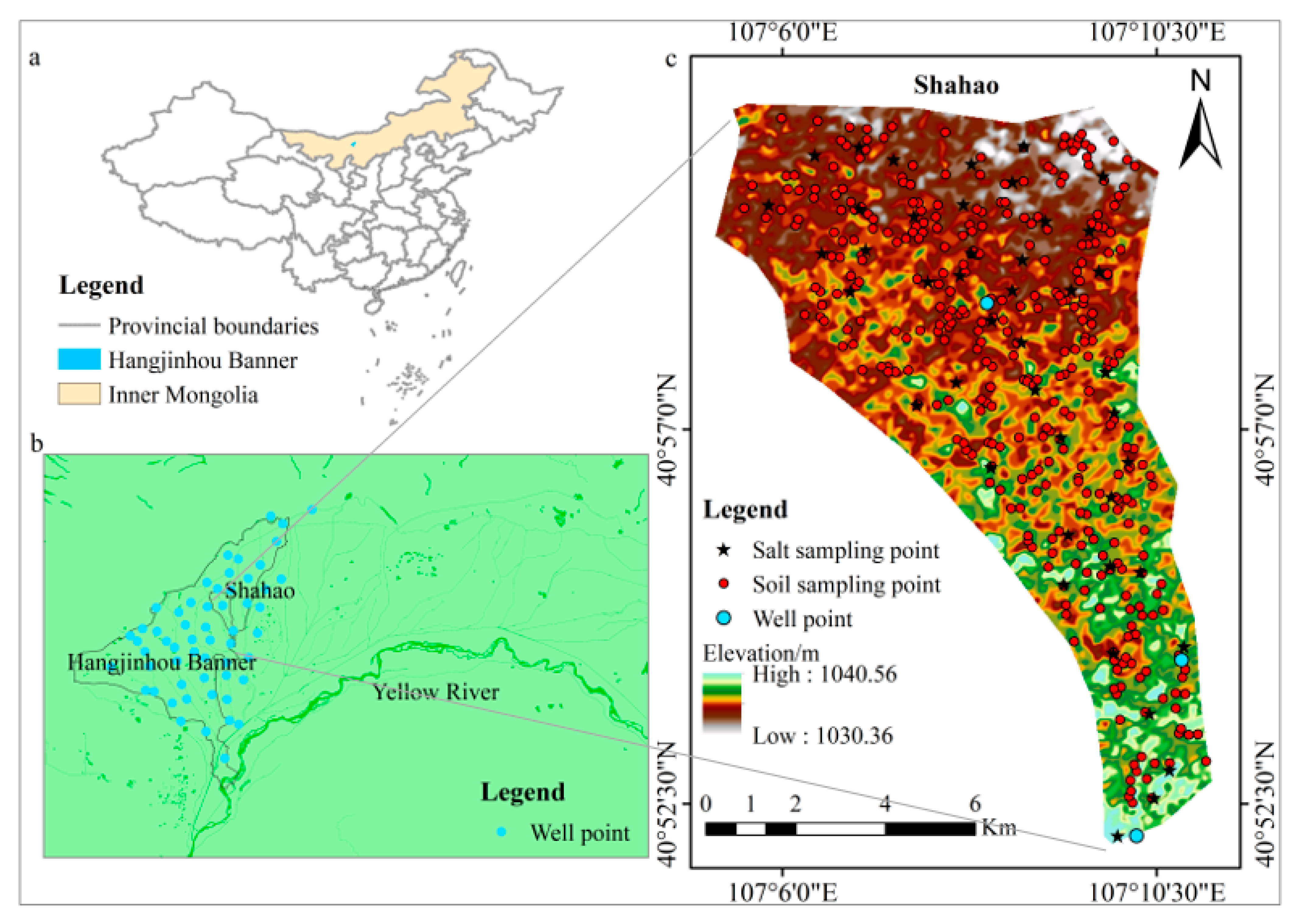
Shahao (107°05′–107°10′ E, 40°52′–41°00′ N) is located in Northern Inner Mongolia (Figure 1), and occupies an area of 52.4 km2. The area is located in an arid zone with a temperate arid climate. The average annual temperature is 7.9 °C, the average annual sunlight time is 3200 h, the average annual precipitation is 136.5 mm and the average annual evaporation is 2306.5 mm. The summers are hot and dry, and the winters are cold with little snow. The main winds are western and northwestern, and the annual average wind speed is ca. 2.7 m/s. Soil freezing begins in middle or late November, the soil is frozen to a depth of 1–1.3 m, all of the frozen layers thaw in mid-May and the time between freezing and thawing is 180 days [27]. Groundwater movement is dominantly vertical, with the main sources being the penetration of field irrigation and channel leakage. The main means of groundwater consumption is evaporation, mainly by vertical movement. The groundwater depth is shallow, and the annual average groundwater depth is 1.66 m. The soil is partly non-salt and partly salted. The main crops are wheat, maize and sunflowers, and there are four to seven rounds of irrigation per year.

Figure 1.
(a) Location of the study area. (b) Locations of groundwater observation wells. (c) Elevation of the land surface above mean sea level, and locations of sampling points.
2.2. Data and Method
2.2.1. Data Collection
The data involved in this study mainly include soil texture, groundwater depth and soil salinity and alkalinization (Table 1).

Table 1.
Data collection type.
Soil Texture Data
In November 2009, the soil survey was conducted in Shahao. The sampling point was selected from the Shahao base map of 1:10,000, whose number was set to 7 in per square kilometers. A total of 343 soil-sampling points (Figure 1c) were collected, and each sampling point used GPS positioning, latitude and longitude coordinates, and recorded the land-use type and vegetation type of the sample point. Since the soil in Shahao was non-salt and salted soil, 5 layers were set in the vertical direction of the sampling point, and thickness of each layer was 20 cm, and each soil sample was 500 g; the soil sample was removed and placed into the sampling bag. We distinguished that the particle size was greater than or less than 0.01 mm in the laboratory, then calculated the percentage of soil particles. The soil texture was determined according to the soil texture classification standard for this technical specification (Table 2). According to the depth and thickness of the clay, it was divided into different soil types, and the naming rules are shown in Table 3.
Table 2.
Soil texture classification.
Table 3.
Nomenclature for soil types with clay in the soil profile.
Groundwater Depth Data
The groundwater depth is automatically monitored by the water-level gauge (HOBO U20-001-02, USA) and the wireless transmission water-level gauge, which was monitored once every 2 h and, at the same time, the groundwater depth was manually monitored once every 6 days. The hydrologic year extends from the autumn irrigation of one year to the end of the crop-growth period of the next year. The monthly average groundwater depth data of 57 long-term observation wells (Figure 1b) covering the irrigation area during the 2008 hydrological year (October 2007 to September 2008) were organized in Excel.
Soil Salinity and Alkalinization Data
From 20 April to 27 April 2010, prior to the summer irrigation, samples to assess soil salinity and alkalinity were collected. A total of 50 soil samples were obtained at a density of one sampling point per square kilometer (Figure 1c). Each sampling point was divided into three layers: the surface (0–10 cm depth); the middle (10–20 cm depth) and the deep (20–50 cm depth) layers. The soil samples were naturally air-dried, ground and sieved through a 2 mm sieve in the laboratory. The sieved samples were used to produce soil-saturated slurry leachates with a soil-to-water ratio of 1:5. Soil salinity was measured with a conductivity meter (model DDSJ-308A, Shanghai, China) and the pH values were obtained by using a pH meter (model PB-21, Shanghai, China), as indicators of the degree of soil salinization [28,29,30] (Table 4).
Table 4.
Soil salinization classification.
2.2.2. Thiessen Polygon
For a set of discrete control points on the plane, the Thiessen polygon of any point Pi is defined as [31]:
where x is any point on the plane; d(x, Pi) and d(x, Pj) are the Euclidean distances from x to Pi and Pj, respectively; and V(Pi) is the Thiessen polygon of point Pi.
The Thiessen polygon can be generated as follows: adjacent control points in the discrete point set P on the plane are connected in pairs, and lines perpendicular to the connecting lines are drawn. The Thiessen polygon is defined by the intersection of perpendicular lines.
2.2.3. Inverse Distance Weighting
The IDW method is based on the principle of similarity, i.e., the closer the distance, the more similar the properties. The weighted average is calculated with the distance between the interpolation point and the sample point as the weight, and sample points that are closer to the interpolation point are given more weight [11]. The formula for IDW is as follows:
where Z is the estimated value of the interpolation point; Zi (i = 1 − n) is the measured sample value; n is the number of samples involved in the calculation and Di is the distance from the interpolation point to the i-th station. The parameter p is the power of distance, which markedly affects the interpolation: the higher the power, the smoother the interpolation result. The parameter p is chosen so as to minimize the mean absolute error. For p = 2, the method is called inverse distance squared weighting. The inverse distance interpolation method is suitable for cases in which the sampling points are evenly distributed and cover the entire area.
In this study, the area covered by each of the 57 long-term observation wells was 40 km2, and sampling points were evenly arranged at a density of one sampling point per square kilometer, so this method can be used for interpolation. Moreover, the distribution of submersible observation wells was not dense, and the IDW helps to improve the accuracy of the interpolated data.
2.2.4. Particle Analysis Process
- (1)
- Place the soil in a cool place to dry, fully roll it with a wooden shovel, then sieve it with a 1 mm sieve;
- (2)
- Standardize the sieved soil samples according to the operating procedures of the laser particle-size analyzer, and accurately record the results;
- (3)
- After completing the measurement test, we used the particle-size analysis software (Talwin) to process the data.
3. Results
3.1. Spatial Analysis of Soil Texture and Land Use
The results of the particle analysis of soil samples demonstrates that the soil textures of Shahao are sandy loam, light loam and light clay (Table 5). The soil is meadow soil, and the soil-type codes of the meadow soil all have “3” as the first number. There are nine soil subtypes in Shahao (Table 6).
Table 5.
Particle composition and bulk density of different soil textures in Shahao.
Table 6.
Soil subclasses and codes of meadow soil in Shahao.
Create a soil sampling point distribution layer based on the latitude and longitude coordinates of the sampling points measured by GPS, draw the Thiessen polygon and cut the Thiessen polygon according to the boundary layer of Shahao to obtain the Thiessen polygon distribution map of Shahao (Figure 2). The soil types in Shahao showed a “flower arrangement” distribution, which intuitively reflected the soil characteristics of “one step, three soil types”. Among them, the soil distribution of full-profile sandy loam-sandy soil was the most extensive, with an area of 21.85 km2, accounting for 41.7% of the total area, while the distribution of thin interlayer sticky light sandy loam soil was the least, with an area of 0.56 km2, accounting for only 1.1% of the total area.
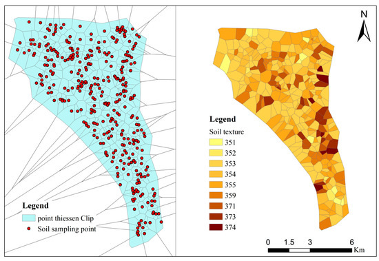
Figure 2.
Thiessen polygon and soil texture distribution in Shahao.
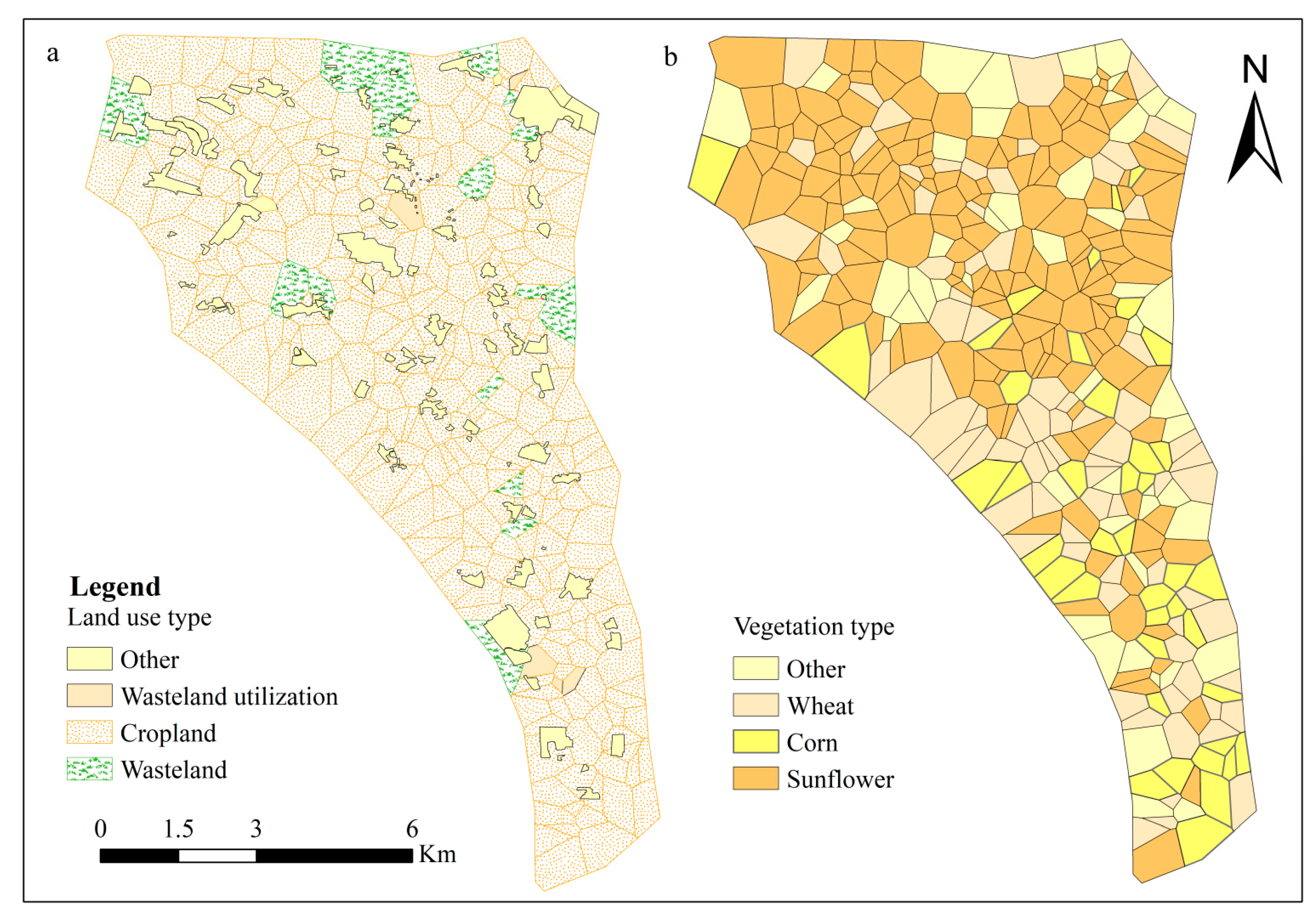
In the soil survey, there were three main land-use types in Shahao, including cropland, wasteland and wasteland reuse. The crops grown were wheat, sunflower, corn, melon, cabbage, tomato, gourd, wolfberry and alfalfa, and the main vegetation of the wasteland in the area were red willow, artemisia, reed and weeds. It can be observed from Figure 3a that the land-use type in Shahao is mainly cropland, accounting for 91% (about 47.7 km2), followed by wasteland reuse and wasteland, accounting for 8.82% (about 4.6 km2), respectively. In order to simplify the planting structure, combined with the actual planting situation in Shahao, the plants in Shahao are divided into four categories (Figure 3b): sunflower, wheat, corn and other plants. The main crops in the survey area are wheat and sunflower, whose planting area accounts for 85.06% (about 44.57 km2) of the entire survey area.
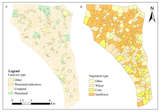
Figure 3.
Distributions of (a) land-use types and (b) vegetation in Shahao.
3.2. Spatial and Temporal Distributions of Groundwater Depth
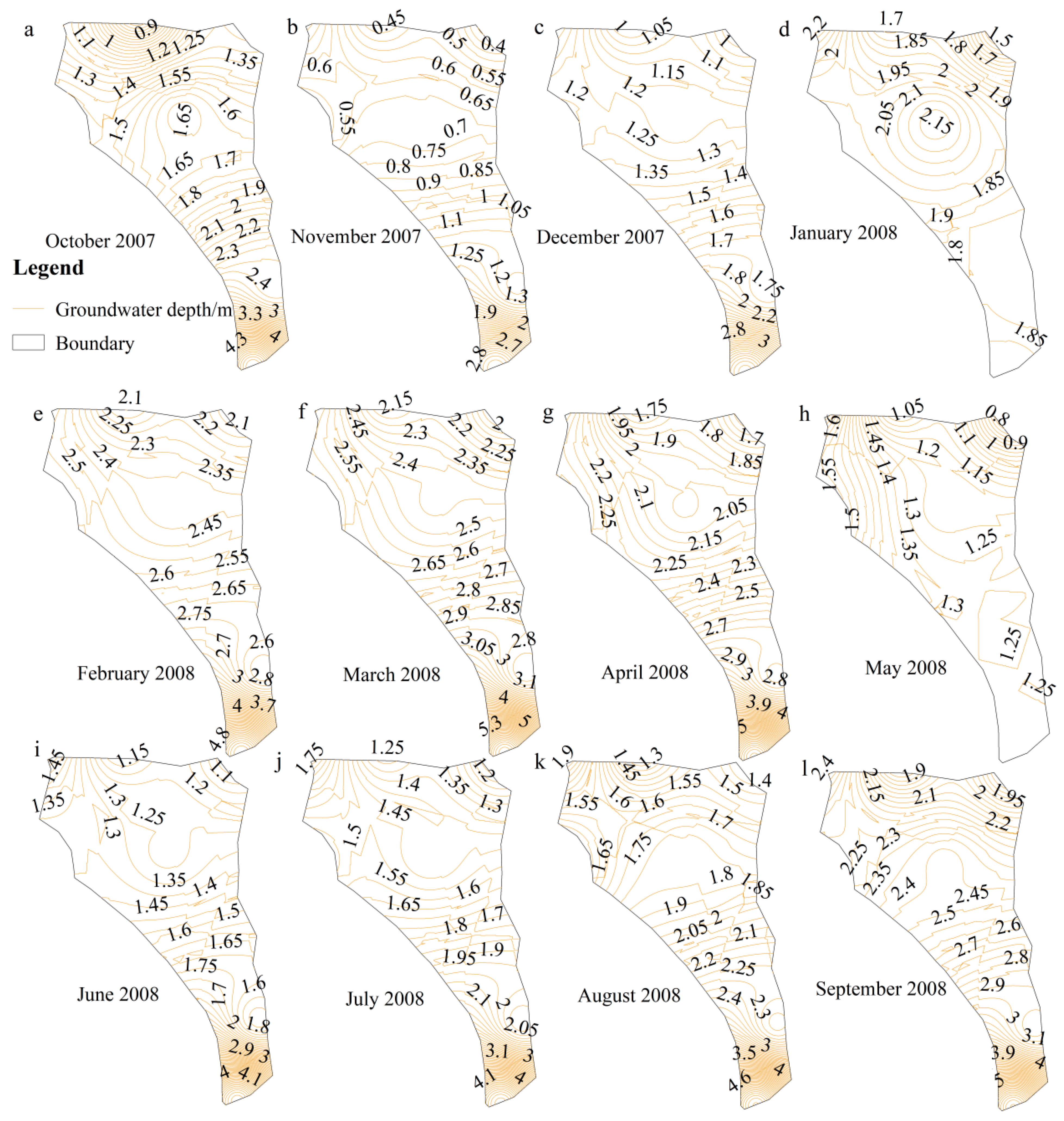
Using the GIS Surface Analysis tool, the spatial distribution raster map of groundwater depth in Shahao from October 2007 to September 2008 was converted into a spatial distribution curve map at 5 cm intervals (Figure 4). Overall, the groundwater depth of Shahao gradually decreases from south to north, because the topography of the study area is higher in the south and lower in the north (Figure 1c), and the average height difference between north and south is 2 m. In addition, the southern part of the study area contains the Hangjinhouqi towns. Most of the water for urban residents and industrial use is obtained from groundwater extraction, whereas the northern part of the study area contains irrigated farmland, and the large amount of irrigation from the Yellow River causes the groundwater level of the farmland to be higher.
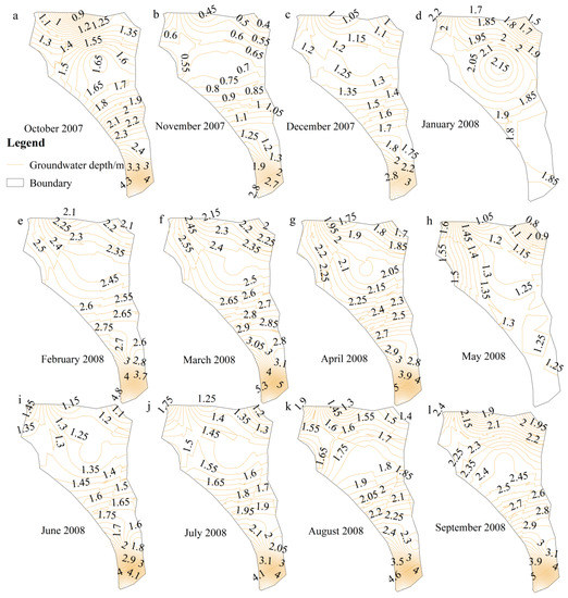
Figure 4.
Maps of groundwater depth during one hydrological year (a–l, October 2007 to September 2008) in Shahao.
Maps of groundwater depth before and after autumn irrigation are shown in Figure 4a,b. During the crop-growth period before the autumn irrigation, soil water was consumed in large quantities and the groundwater depth was relatively low. The autumn irrigation is the largest input of water of the year. At that time, there were no crops on the soil surface, so a large amount of the irrigation water seeped deep into groundwater, causing the groundwater depth in the entire study area to markedly decrease.
Maps of groundwater depth during the freezing period (December 2007 to March 2008) are provided in Figure 4c–f. During December, the ambient temperature gradually decreased, the soil freezing depth continued to increase, groundwater flowed to the surrounding areas with low water levels [32] and the groundwater depth continued to increase. During March, the groundwater depth was the lowest for the whole year.
Maps of groundwater depth in the crop-growth period (April to September) are illustrated in Figure 4g–l. In April, the time of spring ploughing and sowing, the ambient temperature continued to rise, the permafrost thawed gradually and the thawed soil water leaked through the soil pores. However, because the soil was not completely thawed, the groundwater level rose slowly. The frozen soil was fully thawed in May, and most of the water stored in the soil went to replenish groundwater. The first (and largest) irrigation occurred during the growth period, while the crops were emerging but required less water than at other times; thus, a large amount of irrigation water seeped deep into the groundwater. From June to September, the groundwater depth continued to increase, and irrigation continued during this period. Part of the irrigation water was directly used by crops through the soil, and part of the remainder was converted into groundwater. There was also a small evapotranspiration loss as a result of the dry climate and low rainfall levels. When the soil moisture was not sufficient to meet the needs of crop growth, the groundwater was replenished by soil capillary rise, so the effective use of irrigation water was achieved through the action of groundwater.
3.3. Spatial Distribution of Soil Salt and Alkalinity at Different Depths
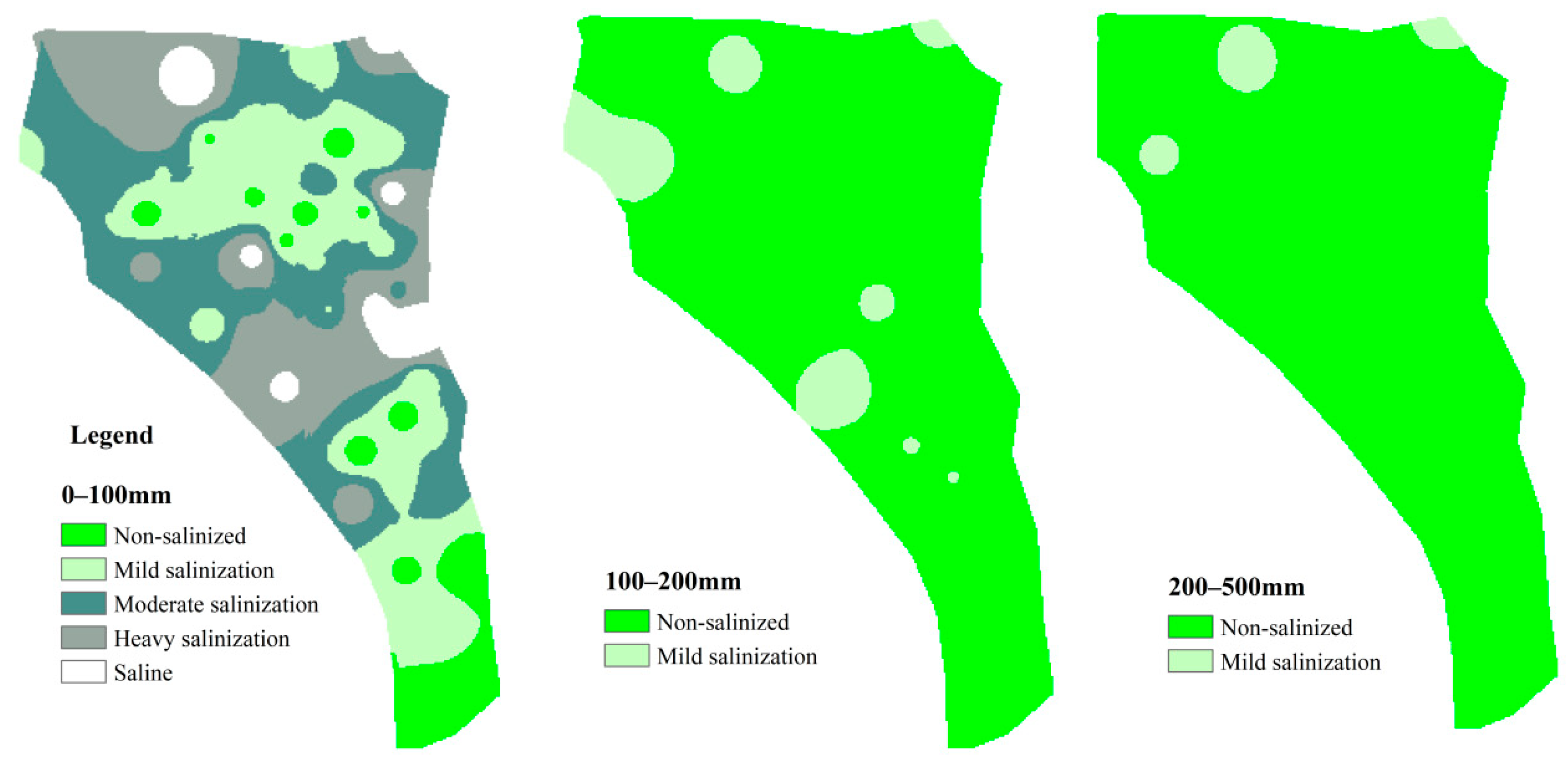
Using the Spatial Analysis tool in ArcGIS 10.2 software, the IDW method was applied to spatially interpolate the salinity and pH values of the sampling points. The spatial distributions of salt and alkalinity were visualized by the salinization/alkalization grade, and maps of soil salt and alkali were drawn for each soil layer (Figure 5 and Figure 6). Spatially, the distribution trends of salinity and alkalinity in each layer of soil were consistent, and the salinity and alkalinity were higher in the central and northern parts of the study area. Vertically, soil salinity and alkalinity generally decreased with increasing depth.

Figure 5.
Spatial distribution of soil salinization in Shahao.

Figure 6.
Spatial distribution of soil alkalinity in Shahao.
In the salinization map (Figure 5), the surface soil layer (0–100 mm depth) was the most saline [33], and the distribution of salinity was the most complex. The area statistics tool of ArcGIS was used to calculate the proportion and area of different salinization grades in this layer of soil: 28.6% of the surface layer was heavily salinized. The crop emergence rate of heavily salinized cropland was only 30–50%, and almost no grass grew on the saline soil, which could not be cultivated without irrigation or improvement. Approximately 33.6% of the land was affected by moderate salinization; in these areas, the crop emergence rate was relatively low, approximately 50–80%. This salinization is an important reason why irrigation should be conducted before farming. Salt in the surface soil was moved into the deep soil or groundwater through leaching by irrigation, reducing the salt content at the surface and improving the emergence and survival rates of planted crops.
In the alkalinity map (Figure 6), the alkalinity distribution is consistent among the three soil layers. The area of strongly alkaline soil was very small, less than 1% of the total land area. Alkaline soils were widespread in the surface-to-middle soil, accounting for 55.2–62.5% of the total land area. Deeper soils were less alkaline, with alkaline soils accounting for 26.1% of the total land area in this depth range. The main crops in this region, wheat, maize and sunflower (Figure 3b), had a suitable pH range of 6.5–7.5, i.e., neutral to slightly alkaline soils. Soil that does not meet the pH requirement limits crop growth and must be improved.
4. Discussion
Shahao has certain unique natural conditions, such as climate, topography, soil and groundwater. The groundwater depth varies with autumn irrigation, the freezing period and the crop-growth period during the year [34] (Figure 4). Spatially, the groundwater depth is higher in the upstream area and low in the downstream area (Figure 4). The topography of Shahao is high in the south and low in the north (Figure 1c), which influences the regional pattern of groundwater depth. The groundwater depth in turn indirectly affects soil-water transport, resulting in the accumulation of salt in the soil and increased relative concentrations of Na+ in the soil solution [35,36], meaning that the native soil was influenced by salinization prior to development.
The crop emergence rate of heavily salinized cropland is only 30–50%, and almost no grass grows on the saline soil, which cannot be cultivated without irrigation (Figure 5 and Figure 6). Irrigation from the diversion of the Yellow River ensures a sufficient water supply for agriculture while leaching the soil salinity. This irrigation enables the development and utilization of this area, but is also an important factor causing the high soil salinity. First, because of the high salt content of the Yellow River itself and extensive irrigation and farming techniques, salt accumulates in the soil in the root layer of crops, which in turn leads to the occurrence of secondary soil salinization and deterioration of the water–soil environment. Second, autumn irrigation is perfumed before the soil freezes in autumn and winter every year. The autumn irrigation is the largest input of water during the year. The irrigation water carries a large amount of soluble salts and freezes in the soil. When the soil melts in spring, the exposed soil surface and strong evaporation lead to salt enrichment in the surface soil [37,38,39]. Enrichment is greater toward the surface [40,41] (Figure 5), resulting in stronger soil alkalinity in the surface and middle layers (Figure 6), which is the local famous “spring soil salt-return phenomenon”. Finally, although some soluble salts and Na+ in the soil can reach the deep soil or groundwater through leaching by irrigation water and deep seepage, the salt does not flow out of the soil because of poor drainage [42,43]. When the groundwater level rises seasonally and with irrigation (Figure 4a,b,i–l), under the action of strong evaporation, ions return to the surface soil [44]; thus, irrigation water leaching cannot solve the problem of soil salinization and alkalinization by itself.
Therefore, to control soil salinization and alkalinization in the Hetao irrigation area, multi-factor linkage control must be conducted. First, irrigation must be improved; specifically, more water should be introduced in areas with severe salinization, and less non-salinized and mildly salinized areas should be irrigated. Second, farming techniques must be improved, and salt- and alkaline-tolerant crops should be selected. Third, in areas with severe salinization and alkalinization, chemical amendments and other improvement measures should be applied in combination with irrigation and leaching to control salt and alkalinity. Overcoming the difficulties, speeding up the construction of drainage systems and improving the drainage environment are also important measures. Only by adhering to the principle of multi-party governance can the problem of salinization in the Hetao irrigation area be solved, the agricultural water–soil environment be improved and productivity be increased.
5. Conclusions
In this paper, the factors influencing soil-water transport in saline–alkali land along the Yellow River and the spatial distribution of soil salinization were analyzed. Using ArcGIS 10.2 software, spatial interpolation was applied to the salinization data of salt sampling points prior to summer irrigation and groundwater depth data for one hydrological year. The main findings of the study are as follows:
- (1)
- Nine soil types are present in Shahao, which exhibit strong spatial variability. Full profile sandy loam–sand soil is the most common type, accounting for 41.7% of the total area. Salt and alkali exhibit the same trends of spatial distribution at different soil depths. In the soil profile, salinity and alkalinity are higher and exhibit wider ranges closer to the soil surface.
- (2)
- The annual dynamic changes of groundwater depth can be divided into three periods, including autumn irrigation, the freezing period and the crop-growth period. Groundwater movement exhibits vertical infiltration and evaporation, because of the influence of certain external conditions, such as crop transpiration, ambient temperature and human activities.
- (3)
- The high salt content of the Yellow River itself, freeze–thaw change and poor drainage are three important factors causing high soil salinity along the Yellow River saline–alkali land. The spring soil salinity recovery caused by autumn irrigation mainly influences the top (0–100 mm depth) soil layer.
Author Contributions
H.L. (Hongfang Li) and J.W. designed the research and prepared manuscript. The data were prepared by H.L. (Hongfang Li), Z.W. and H.L. (Hu Liu); J.W. and H.M. helped revise the manuscript. The manuscript was checked by H.L. (Hongfang Li), J.W., H.L. (Hu Liu), Z.W. and H.M. All authors have read and agreed to the published version of the manuscript.
Funding
This research was funded by the Yinshanbeilu Grassland Eco-hydrology National Observation and Research Station, China Institute of Water Resources and Hydropower Research (MK2022J04), Projects for the Central Government to Guide Local Scientific and Technological Development (2021ZY0031).
Data Availability Statement
The data presented in this study are available on request from the corresponding author.
Conflicts of Interest
The authors declare no conflict of interest.
References
- Nosetto, M.D.; Acosta, A.M.; Jayawickreme, D.H.; Ballesteros, S.I.; Jackson, R.B.; Jobbágy, E.G. Land-use and topography shape soil and groundwater salinity in central Argentina. Agric. Water Manag. 2013, 129, 120–129. [Google Scholar] [CrossRef]
- Abliz, A.; Tiyip, T.; Ghulam, A.; Halik, Ü.; Ding, J.; Sawut, M.; Zhang, F.; Nurmemet, I.; Abliz, A. Effects of shallow groundwater table and salinity on soil salt dynamics in the Keriya Oasis, Northwestern China. Environ. Earth Sci. 2016, 75, 260. [Google Scholar] [CrossRef]
- De Menezes, M.D.; Silva, S.H.G.; Owens, P.R.; Curi, N. Digital soil mapping approach based on fuzzy logic and field expert knowledge. Ciênc. Agrotecnol. 2013, 37, 287–298. [Google Scholar] [CrossRef]
- Pal, S.; Manna, S.; Aich, A.; Chattopadhyay, B.; Mukhopadhyay, S.K. Assessment of the spatio-temporal distribution of soil properties in East Kolkata wetland ecosystem (A Ramsar site: 1208). J. Earth Syst. Sci. 2014, 123, 729–740. [Google Scholar] [CrossRef] [Green Version]
- Behera, S.K.; Shukla, A.K. Spatial Distribution of Surface Soil Acidity, Electrical Conductivity, Soil Organic Carbon Content and Exchangeable Potassium, Calcium and Magnesium in Some Cropped Acid Soils of India. Land Degrad. Dev. 2015, 26, 71–79. [Google Scholar] [CrossRef]
- Paz, J.; Visconti, F.; Zapata, R.; Sanchez, J. Integration of two simple models in a geographical information system to evaluate salinization risk in irrigated land of the Valencian Community, Spain. Soil Use Manag. 2010, 20, 333–342. [Google Scholar] [CrossRef]
- Shit, P.K.; Bhunia, G.S.; Maiti, R. Spatial analysis of soil properties using GIS based geostatistics models. Model. Earth Syst. Environ. 2016, 2, 107. [Google Scholar] [CrossRef] [Green Version]
- Bhunia, G.S.; Shit, P.K.; Maiti, R. Comparison of GIS-based interpolation methods for spatial distribution of soil organic carbon (SOC). J. Saudi Soc. Agric. Sci. 2018, 17, 114–126. [Google Scholar] [CrossRef] [Green Version]
- Panagopoulos, T.; Jesus, J.; Antunes, M.; Beltrão, J. Analysis of spatial interpolation for optimising management of a salinized field cultivated with lettuce. Eur. J. Agron. 2006, 24, 1–10. [Google Scholar] [CrossRef]
- Gumiere, S.J.; Lafond, J.A.; Hallema, D.W.; Périard, Y.; Caron, J.; Gallichand, J. Mapping soil hydraulic conductivity and matric potential for water management of cranberry: Characterisation and spatial interpolation methods. Biosyst. Eng. 2014, 128, 29–40. [Google Scholar] [CrossRef]
- Bogunovic, I.; Mesic, M.; Zgorelec, Z.; Jurisic, A.; Bilandzija, D. Spatial variation of soil nutrients on sandy-loam soil. Soil Till Res. 2014, 144, 174–183. [Google Scholar] [CrossRef]
- Xie, W.; Wu, L.; Zhang, Y.; Wu, T.; Li, X.; Ouyang, Z. Effects of straw application on coastal saline topsoil salinity and wheat yield trend. Soil Tillage Res. 2017, 169, 1–6. [Google Scholar] [CrossRef]
- Min, W.; Guo, H.; Zhou, G. Soil salinity, leaching, and cotton growth as affected by saline water drip irrigation and N fertigation. Acta Agric. Scand. 2016, 66, 489–501. [Google Scholar]
- Luo, S.; Wang, S.; Lei, T. Aggregate-related changes in soil microbial communities under different ameliorant applications in saline-sodic soils. Geoderma 2018, 329, 108–117. [Google Scholar] [CrossRef]
- Wang, G.; Shi, H.; Li, X.; Zheng, Q.; Guo, J.; Wang, W. Analysis of water and salt transportation and balance during cultivated land, waste land and lake system in Hetao Irrigation Area. Shuili Xuebao 2019, 50, 1518–1528. (In Chinese) [Google Scholar]
- Li, J.; Qu, Z.; Chen, J. Effect of Different Thresholds of Drip Irrigation Using Saline Water on Soil Salt Transportation and Maize Yield. Water 2018, 10, 1855. [Google Scholar] [CrossRef] [Green Version]
- Zhang, H.; Li, Y.; Meng, Y.; Cao, N.; Li, D.; Zhou, Z.; Chen, B.; Dou, F. The effects of soil moisture and salinity as functions of groundwater depth on wheat growth and yield in coastal saline soils. J. Integr. Agric. 2019, 18, 2472–2482. [Google Scholar] [CrossRef]
- Lu, Z.; Yang, J.; Liu, G.; Li, J.; Liu, H.; Li, B. Relationship between Soil Salinization and Groundwater Characteristics in the Yellow River Delta. Acta Pedol. Sin. 2017, 54, 1377–1385. [Google Scholar]
- Zeng, Y.; Zhao, C.; Shi, F.; Schneider, M.; Li, Y. Impact of groundwater depth and soil salinity on riparian plant diversity and distribution in an arid area of China. Sci. Rep. 2020, 10, 7272. [Google Scholar] [CrossRef]
- Zhang, H.; Li, D.; Zhou, Z.; Zahoor, R.; Chen, B.; Meng, Y. Soil water and salt affect cotton (Gossypium hirsutum L.) photosynthesis, yield and fiber quality in coastal saline soil. Agric. Water Manag. 2017, 187, 112–121. [Google Scholar] [CrossRef]
- Petheram, C.; Bristow, K.L.; Nelson, P.N. Understanding and managing groundwater and salinity in a tropical conjunctive water use irrigation district. Agric. Water Manag. 2008, 95, 1167–1179. [Google Scholar] [CrossRef]
- Zhang, W.; Zhu, J.; Zhou, X.; Li, F. Effects of shallow groundwater table and fertilization level on soil physico-chemical properties, enzyme activities, and winter wheat yield. Agric. Water Manag. 2018, 208, 307–317. [Google Scholar] [CrossRef]
- Xia, J.; Zhao, X.; Chen, Y.; Fang, Y. Responses of Water and Salt Parameters to Groundwater Levels for Soil Columns Planted with Tamarix chinensis. PLoS ONE 2016, 11, e0145828. [Google Scholar] [CrossRef] [Green Version]
- Zhang, H.; Wang, X.S. The impact of groundwater depth on the spatial variance of vegetation index in the Ordos Plateau, China: A semivariogram analysis. J. Hydrol. 2020, 588, 125096. [Google Scholar] [CrossRef]
- Johansen, O.M.; Andersen, D.K.; Ejrnæs, R.; Pedersen, M.L. Relations between vegetation and water level in groundwater dependent terrestrial ecosystems (GWDTEs). Limnologica 2018, 68, 130–141. [Google Scholar] [CrossRef] [Green Version]
- Wang, G.; Shi, H.; Li, X.; Yan, J.; Akae, T. A Study on Water and Salt Transport, and Balance Analysis in Sand Dune–Wasteland–Lake Systems of Hetao Oases, Upper Reaches of the Yellow River Basin. Water 2020, 12, 3454. [Google Scholar] [CrossRef]
- Tao, J.Y.; Yang, J.S.; Yao, R.J.; Wang, X.P.; Liu, G.M.; Chen, Q. Effects of Soil Salinity on Nitrogen Transformation in Hetao Irrigation District of Inner Mongolia, China. Soils 2020, 52, 802–810. (In Chinese) [Google Scholar]
- Rochfort, S.; Ezernieks, V.; Mele, P.; Kitching, M. NMR metabolomics for soil analysis provide complementary, orthogonal data to MIR and traditional soil chemistry approaches—A land use study. Magn. Reson. Chem. 2015, 53, 719–725. [Google Scholar] [CrossRef]
- Peng, L.; Cheng, H.; Wang, L.J.; Zhu, D.Z. Comparisons the prediction results of soil properties based on Fuzzy C-means clustering and expert knowledge from laboratory Vis-NIR spectroscopy data. Can. J. Soil Sci. 2020, 101, 33–44. [Google Scholar] [CrossRef]
- Yu, H.; Xi, B.; Ma, W.; Li, D.; He, X. Fluorescence Spectroscopic Properties of Dissolved Fulvic Acids from Salined Flavo-aquic Soils around Wuliangsuhai in Hetao Irrigation District, China. Soil Sci. Soc. Am. J. 2011, 75, 1385–1393. [Google Scholar] [CrossRef]
- Casaer, J.; Hermy, M.; Coppin, P.; Verhagen, R. Analysing space use patterns by Thiessen polygon and triangulated irregular network interpolation: A non-parametric method for processing telemetric animal fixes. Int. J. Geogr. Inf. Syst. 1999, 13, 499–511. [Google Scholar] [CrossRef]
- Chen, J.; Gao, X.; Zheng, X.; Miao, C.; Liu, P.; Du, Q.; Xu, Y. Transformation between Phreatic Water and Soil Water during Freeze–Thaw Periods. Water 2018, 10, 376. [Google Scholar] [CrossRef] [Green Version]
- Devkota, M.; Martius, C.; Gupta, R.K.; Devkota, K.P.; McDonald, A.J.; Lamers, J.P.A. Managing soil salinity with permanent bed planting in irrigated production systems in Central Asia. Agric. Ecosyst. Environ. 2015, 202, 90–97. [Google Scholar] [CrossRef]
- Miao, C.; Chen, J.; Zheng, X.; Zhang, Y.; Xu, Y.; Du, Q. Soil Water and Phreatic Evaporation in Shallow Groundwater during a Freeze–Thaw Period. Water 2017, 9, 396. [Google Scholar] [CrossRef] [Green Version]
- Wu, J.; Li, P.; Qian, H.; Fang, Y. Assessment of soil salinization based on a low-cost method and its influencing factors in a semi-arid agricultural area, northwest China. Environ. Earth Sci. 2014, 71, 3465–3475. [Google Scholar] [CrossRef]
- Cui, G.; Lu, Y.; Zheng, C.; Liu, Z.; Sai, J. Relationship between Soil Salinization and Groundwater Hydration in Yaoba Oasis, Northwest China. Water 2019, 11, 175. [Google Scholar] [CrossRef] [Green Version]
- Rahimian, M.H.; Poormohammadi, S. Assessing the Impact of Climate Change on Evapotranspiration and Soil Salinization. In Climate Change and the Sustainable Use of Water Resources; Springer: Berlin/Heidelberg, Germany, 2012; pp. 69–76. [Google Scholar]
- Cui, H.H.; Xian, X.; Tao, W.; Mascellis, R.D.; Mele, G.; Quan, G.Y.; Fei, P.; Tedeschi, A. Effects of saline water irrigation on soil properties in northwest China. Environ. Earth Sci. 2011, 63, 701–708. [Google Scholar]
- Bing, H.; He, P.; Zhang, Y. Cyclic freeze–thaw as a mechanism for water and salt migration in soil. Environ. Earth Sci. 2015, 74, 675–681. [Google Scholar] [CrossRef] [Green Version]
- Feng, J.; Ding, J.; Wei, W. Soil salinization monitoring based on Radar data. Remote Sens. Land Resour. 2019, 31, 195–203. [Google Scholar]
- Wu, C.; Huang, C.; Liu, G.H.; Liu, Q. Spatial prediction of soil salinity in the Yellow River Delta based on geographically weighted regression. Resour. Sci. 2016, 38, 704–713. [Google Scholar]
- Ibrakhimov, M.; Martius, C.; Lamers, J.P.A.; Tischbein, B. The dynamics of groundwater table and salinity over 17 years in Khorezm. Agric. Water Manag. 2011, 101, 52–61. [Google Scholar] [CrossRef]
- Tomaz, A.; Palma, P.; Fialho, S.; Lima, A.; Alvarenga, P.; Potes, M.; Costa, M.J.; Salgado, R. Risk Assessment of Irrigation-Related Soil Salinization and Sodification in Mediterranean Areas. Water 2020, 12, 3569. [Google Scholar] [CrossRef]
- Bian, L.; Wang, J.; Liu, J.; Han, B. Spatiotemporal Changes of Soil Salinization in the Yellow River Delta of China from 2015 to 2019. Sustainability 2021, 13, 822. [Google Scholar] [CrossRef]


Publisher’s Note: MDPI stays neutral with regard to jurisdictional claims in published maps and institutional affiliations. |
© 2022 by the authors. Licensee MDPI, Basel, Switzerland. This article is an open access article distributed under the terms and conditions of the Creative Commons Attribution (CC BY) license (https://creativecommons.org/licenses/by/4.0/).