

Sustainability Indicators of Groundwater Withdrawal in a Heavily Stressed System: The Case of the Acque Albule Basin (Rome, Italy)


Abstract
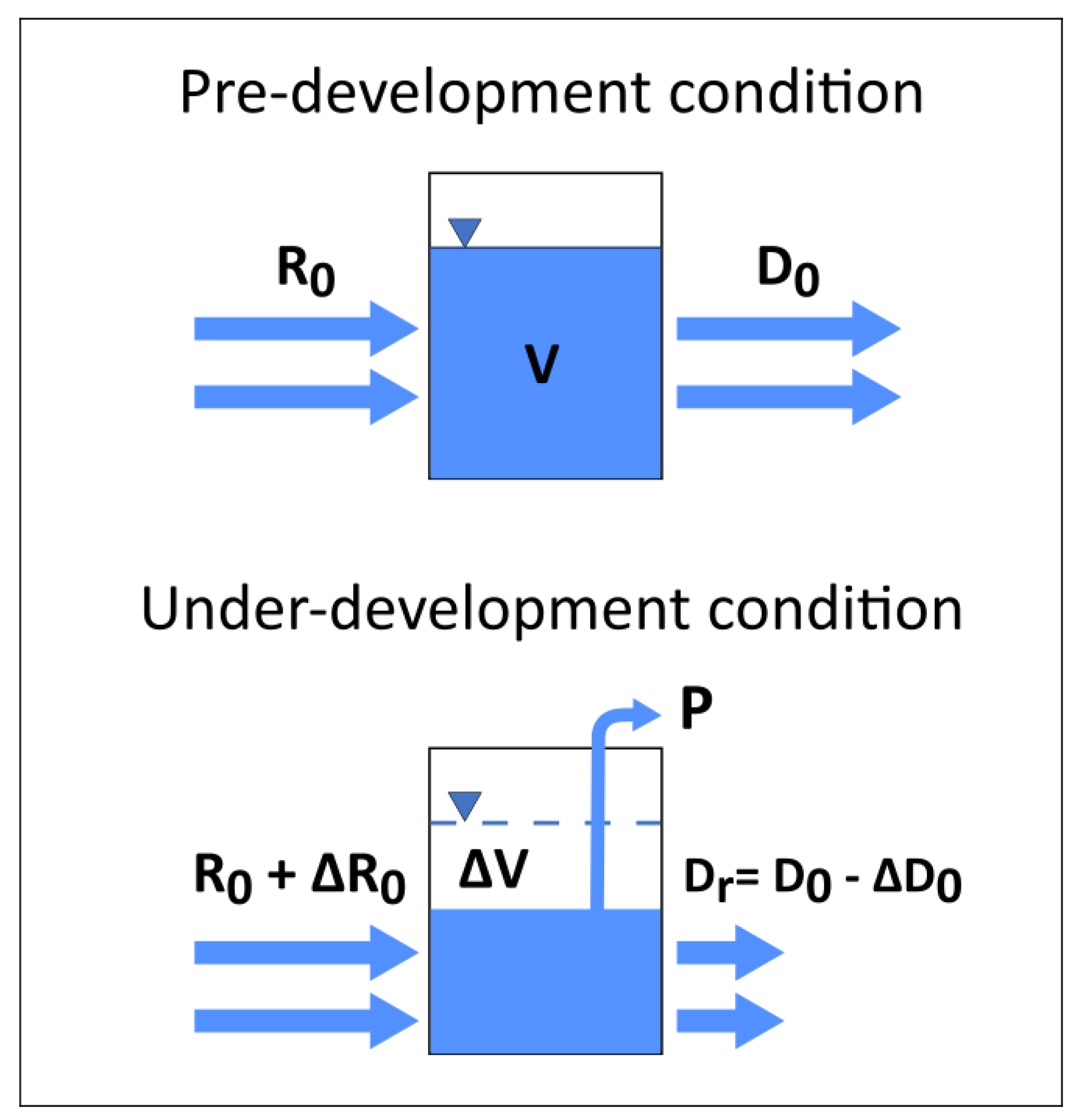
:1. Introduction
2. Background Knowledge on Groundwater Flow and Anthropogenic Impacts in the Acque Albule Basin
3. Materials and Methods
3.1. Investigations
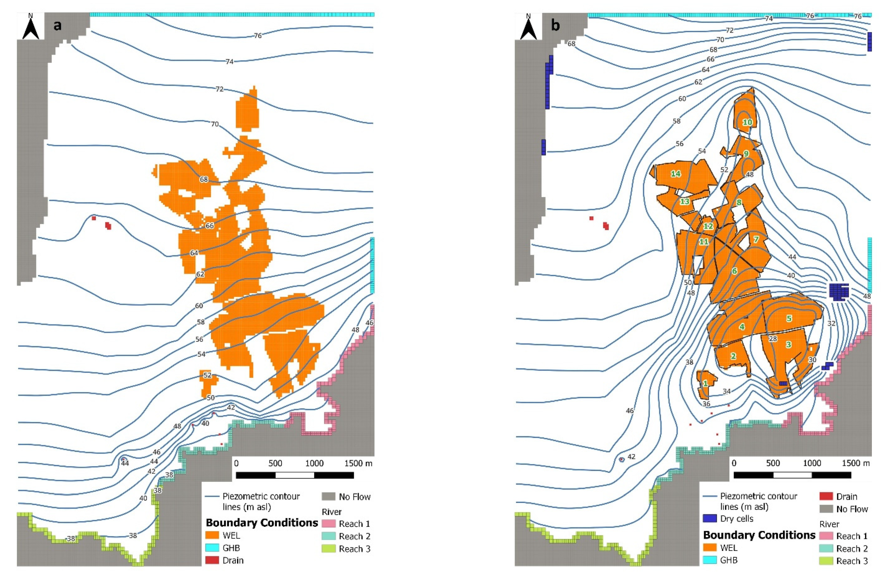
3.2. Groundwater Flow Model
- -
- General Head Boundary (GHB): this condition, assigned to the northern limit of the model to Layers 1 and 3 and to a portion of the eastern border, was used to simulate head-dependent inflows into the system. Head values of GHB were derived from the potentiometric surface map available for the area under natural conditions [40], i.e., when withdrawals from the quarry area were limited;
- -
- No Flow boundary: this condition was assigned to the northwestern limit of the model, where null exchange between the plain and the surrounding reliefs has been recognized [33,34]; the same condition was also assigned to the southern sector of the model beyond the Aniene River, which does not affect the investigated system;
- -
- DRAIN: this head-dependent flux boundary allows the outflow from the system. This condition was applied to the stress periods SP1, SP2 and SP3 (see below) to the Regina, Colonnelle (Acque Albule springs) and S. Giovanni lakes and to the minor springs located in the southern sector of the study area; the drain condition was also applied to simulate the drainage from the quarries during the calibration process for stress period SP2;
- -
- RIVER: this condition simulates the water exchanges between river and groundwater. This condition was assigned to the southern boundary of the model where the Aniene River flows, taking into account the elevations of the river and distinguishing three different conductance zones during calibration process (named as Reach 1, Reach 2 and Reach 3).
4. Results
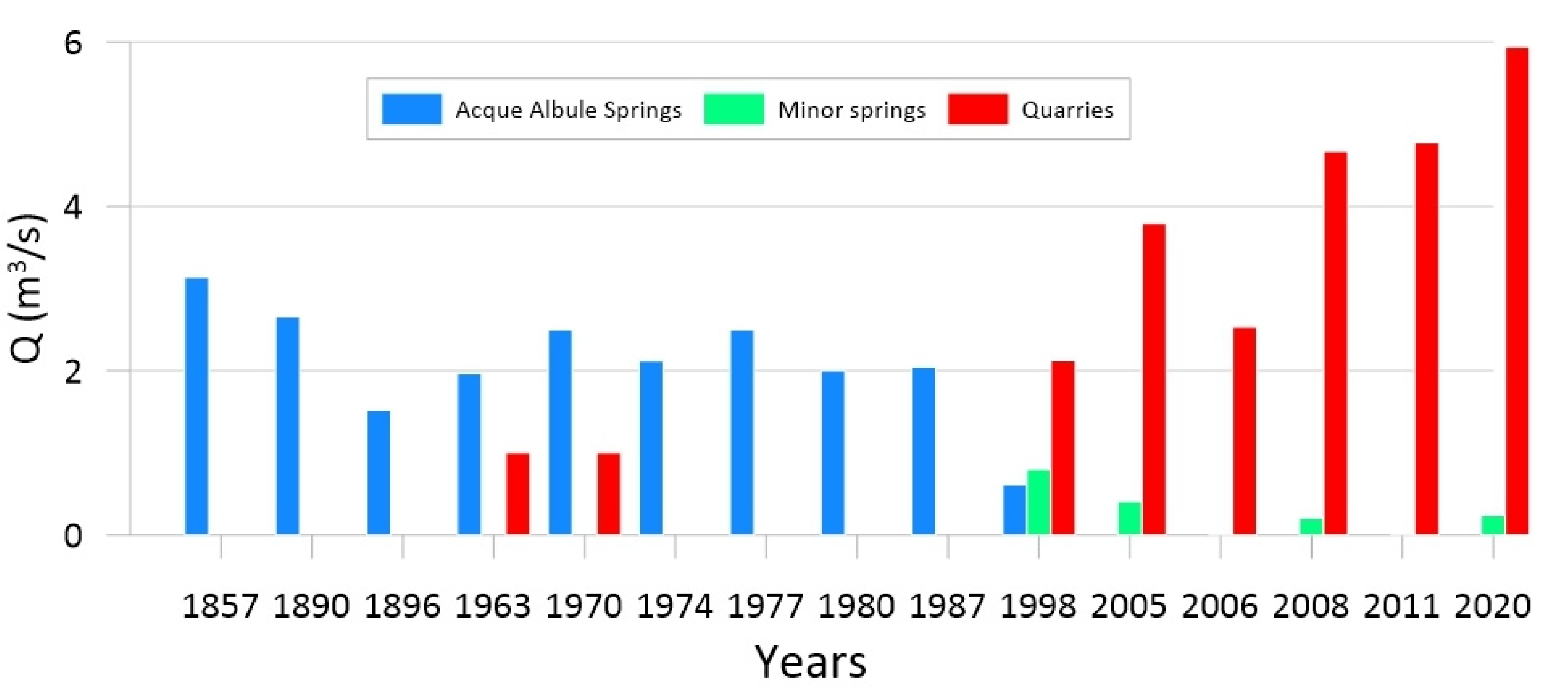
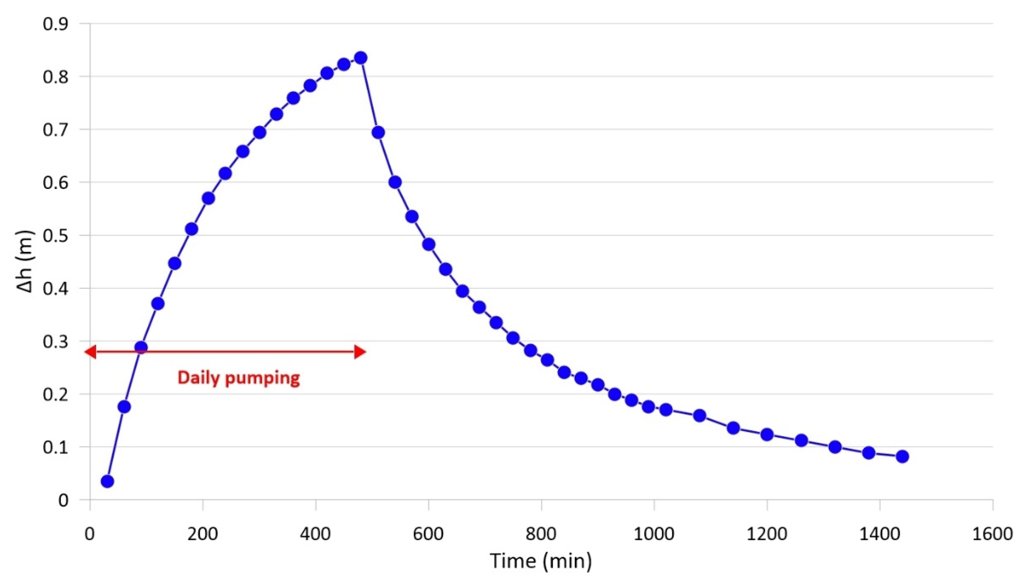
4.1. Variation of the Groundwater Flow and Level in the Plain
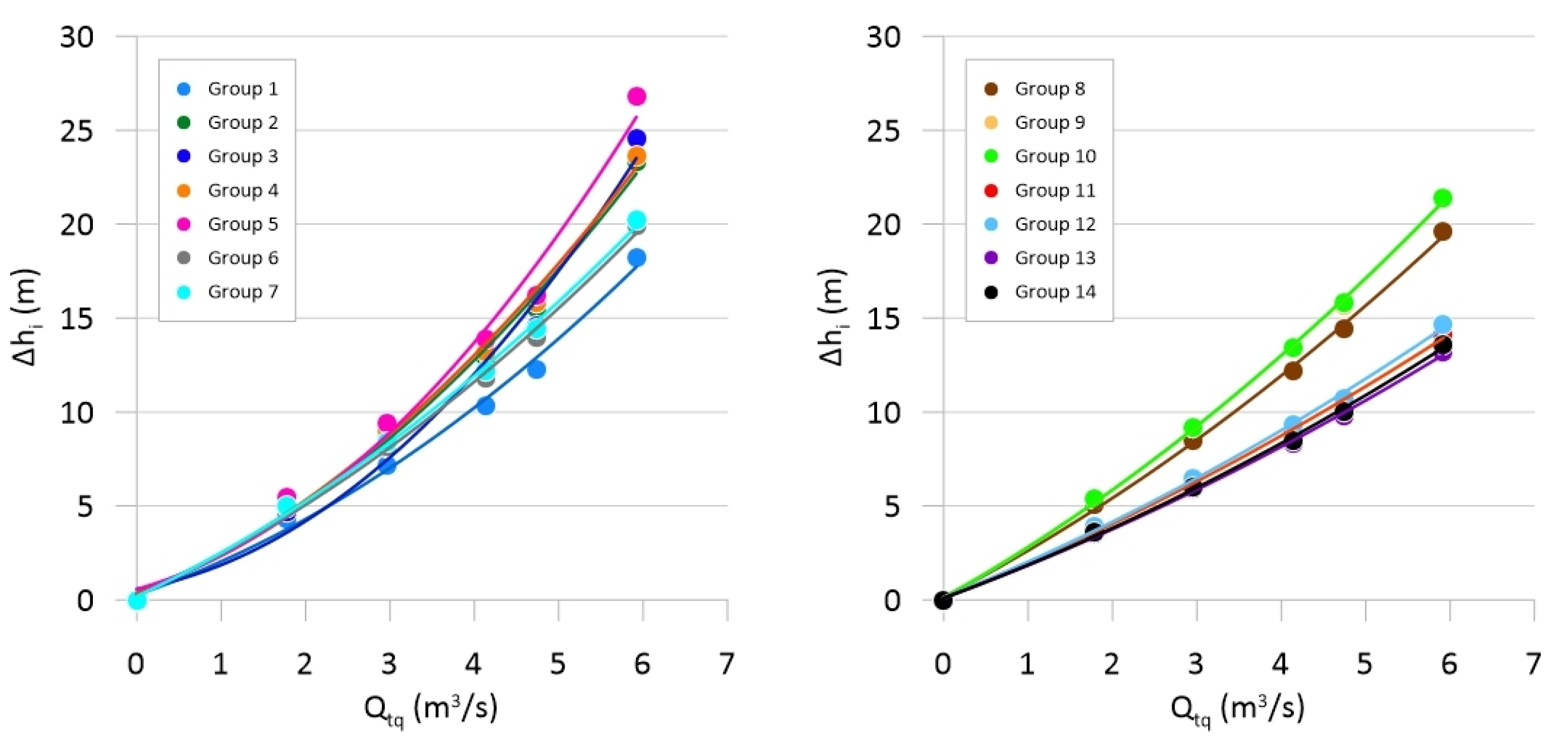
4.2. Results of Groundwater Modeling
- -
- Δhi is the drawdown in the i-th group of quarries,
- -
- Qi is the dewatering discharge from the i-th group of quarries,
- -
- a, b and c are coefficients depending on the location of the group in the groundwater flow pattern, the pumping rate from each group and the interference of pumping from the adjacent groups.
- -
- IQs is the increase in flow of the Acque Albule spring in response to the variation of pumping rate from the i-th group of quarries,
- -
- QsSP1 is the flow discharge of the Acque Albule springs under natural conditions,
- -
- QsSP3 is the flow discharge of the Acque Albule springs with maximum pumping from all groups of quarries,
- -
- Qi is the pumping flow from the i-th quarry
- -
- IQr is the increase in flow of the Aniene River in response to the variation of the pumping rate from the i-th group of quarries,
- -
- QrSP1 is the flow discharge towards the Aniene River under natural conditions,
- -
- QrSP3 is flow discharge toward the Aniene River with maximum pumping from all groups of quarries.
5. Discussion
6. Conclusions
Author Contributions
Funding
Data Availability Statement
Acknowledgments
Conflicts of Interest
References
- Alley, M.; Lake, S.A. The journey from safe yield to sustainability. Ground Water 2004, 42, 12–16. [Google Scholar] [CrossRef] [PubMed]
- Pierce, S.A.; Sharp, J.M.; Guillaume, J.H.A., Jr.; Mace, R.E.; Eaton, D.J. Aquifer-yield continuum as a guide and typology for science-based groundwater management. Hydrogeol. J. 2013, 21, 331–340. [Google Scholar] [CrossRef]
- Gleeson, T.; Cuthbert, M.; Ferguson, G.; Perrone, D. Global groundwater sustainability, resources, and systems in the Anthropocene. Annu. Rev. Earth Planet. Sci. 2020, 48, 431–463. [Google Scholar] [CrossRef] [Green Version]
- Elshall, A.S.; Arik, A.D.; El-Kadi, A.I.; Pierce, S.; Ye, M.; Burnett, K.M.; Wada, C.A.; Bremer, L.L.; Chun, G. Groundwater sustainability: A review of the interactions between science and policy. Environ. Res. Lett. 2020, 15, 093004. [Google Scholar] [CrossRef]
- Alley, W.M.; Reilly, T.E.; Franke, O.L. Sustainability of ground-water resources. US Geol. Surv. Circ. 1999, 1186, 1–79. [Google Scholar]
- Lee, C.H. The determination of safe yield of underground reservoirs of the closed basin type. Trans. Am. Soc. Civ. Eng. 1915, 78, 148–151. [Google Scholar] [CrossRef]
- Conkling, H. Utilization of groundwater storage in stream system development. Proc. Am. Soc. Civ. Eng. 1945, 111, 33–62. [Google Scholar]
- Thomas, H.E. The Conservation of Groundwater; McGraw-Hill Book Company: New York, NY, USA, 1951; p. 327. [Google Scholar]
- Domenico, P.A. Concepts and Models in Groundwater Hydrology; McGraw-Hill: New York, NY, USA, 1972. [Google Scholar]
- Sophocleous, M. From safe yield to sustainable development of water resources: The Kansas experience. J. Hydrol. 2000, 235, 27–43. [Google Scholar] [CrossRef]
- Bredehoeft, J.D. The water budget myth revisited: Why hydrogeologists model. Groundwater 2002, 40, 340–345. [Google Scholar] [CrossRef]
- Kalf, F.R.; Wooley, D.R. Applicability and methodology of determining sustainable yield in groundwater systems. Hydrogeol. J. 2005, 13, 295–312. [Google Scholar] [CrossRef]
- Devlin, J.; Sophocleous, M. The persistence of the water budget myth and its relationship to sustainability. Hydrogeol. J. 2005, 13, 549–554. [Google Scholar] [CrossRef]
- Zhou, Y. A critical review of groundwater budget myth, safe yield and sustainability. J. Hydrol. 2009, 370, 207–213. [Google Scholar] [CrossRef]
- Konikow, L.F.; Leake, S.A. Depletion and capture: Revisiting “the source of water derived from wells”. Groundwater 2014, 52, 100–111. [Google Scholar] [CrossRef]
- Faccenna, C. Structural and hydrogeological features of Pleistocene shear zones in the area of Rome (central Italy). Ann. Geofis. 1994, 37, 121–133. [Google Scholar] [CrossRef]
- Faccenna, C.; Soligo, M.; Billi, A.; De Filippis, L.; Funiciello, R.; Rossetti, C.; Tuccimei, P. Late Pleistocene depositional cycles of the Lapis Tiburtinus travertine (Tivoli, central Italy): Possible influence of climate and fault activity. Glob. Planet. Chang. 2008, 63, 299–308. [Google Scholar] [CrossRef]
- Pentecost, A.; Tortora, P. Bagni di Tivoli, Lazio: A modern travertine depositing site and its associated microorganism. Boll. Soc. Geol. It. 1989, 108, 315–324. [Google Scholar]
- Minissale, A.; Kerrick, D.M.; Magro, G.; Murrell, M.T.; Paladini, M.; Rihs, S.; Sturchio, N.C.; Tassi, F.; Vaselli, O. Geochemistry of Quaternary travertines in the region north of Rome (Italy): Structural, hydrological and paleoclimatic implications. Earth Planet. Sci. Lett. 2002, 203, 709–728. [Google Scholar] [CrossRef]
- Billi, A.; Valle, A.; Brilli, M.; Faccenna, C.; Funiciello, R. Fracture-controlled fluid circulation and dissolutional weathering in sinkhole-prone carbonate rocks from central Italy. J. Struct. Geol. 2006, 29, 385–395. [Google Scholar] [CrossRef]
- La Vigna, F.; Mazza, R.; Capelli, G. Detecting the flow relationships between deep and shallow aquifers in an exploited groundwater system, using long-term monitoring data and quantitative hydrogeology: The Acque Albule basin case (Rome, Italy). Hydrol. Process. 2013, 27, 3159–3173. [Google Scholar] [CrossRef]
- Petitta, M.; Primavera, P.; Tuccimei, P.; Aravena, R. Interaction between deep and shallow groundwater systems in areas affected by Quaternary tectonics (Central Italy): A geochemical and isotope approach. Environ. Earth Sci. 2010, 63, 11–30. [Google Scholar] [CrossRef]
- Carucci, V.; Petitta, M.; Aravena, R. Interaction between shallow and deep aquifers in the Tivoli Plain (central Italy) enhanced by groundwater extraction: A multi-isotope approach and geochemical modeling. Appl. Geochem. 2012, 27, 266–280. [Google Scholar] [CrossRef]
- Boni, C.; Bono, P.; Capelli, G. Schema idrogeologico dell’Italia Centrale. Mem. Soc. Geol. It. 1986, 35, 991–1012. [Google Scholar]
- Capelli, G.; Cosentino, D.; Messina, P.; Raffi, R.; Ventura, G. Modalità di ricarica e assetto strutturale dell’acquifero delle sorgenti Capore—S. Angelo (Monti Lucretili—Sabina Meridionale). Geol. Romana 1987, 26, 419–447. [Google Scholar]
- Capelli, G.; Mazza, R.; Taviani, S. Studi idrogeologici per la definizione degli strumenti operativi del piano stralcio per l’uso compatibile delle risorse idriche sotterranee nell’ambito dei sistemi acquiferi prospicienti i territori vulcanici laziali; Università degli Studi di Roma Tre: Roma, Italy, 2005; Unpublished work. [Google Scholar]
- Cosentino, D.; Pasquali, V. Carta Geologica Informatizzata della Regione Lazio; Università degli Studi Roma Tre—Dipartimento di Scienze Geologiche, Regione Lazio—Agenzia Regionale Parchi—Area Difesa del Suolo: Roma, Italy, 2012. [Google Scholar]
- Acque Albule S.p.A. Indagini Idrogeologiche per Determinare Le Cause dei Dissesti Agli Edifici di via Cesare Augusto e Aree Limitrofe, in Località Bagni di Tivoli; Bono, P., Ed.; Technical Report; Università degli Studi di Roma La Sapienza: Roma, Italy, 2005. [Google Scholar]
- Della Porta, G.; Croci, A.; Marini, M.; Kele, S. Depositional architecture, facies character and geochemical signature of the Tivoli travertines (Pleistocene, Acque Albule Basin, Central Italy). Res. Paleontol. Stratigr. 2017, 123, 487–540. [Google Scholar] [CrossRef]
- Maxia, C. Il Bacino delle Acque Albule (Lazio). Contr. Sc. Geol. Suppl. Ric. Sc. 1950, 20, 3–20. [Google Scholar]
- Del Bon, A.; Sbarbati, C.; Brunetti, E.; Carucci, V.; Lacchini, A.; Marinelli, V.; Petitta, M. Groundwater flow and geochemical modeling of the Acque Albule thermal basin (Central Italy): A conceptual model for evaluating influences of human exploitation on flowpath and thermal resource availability. Cent. Eur. Geol. 2015, 58, 152–170. [Google Scholar] [CrossRef]
- Lombardi, L. Studio idrogeologico del Bacino delle Acque Albule. Roma, Italy, 2005; Unpublished work. [Google Scholar]
- La Vigna, F.; Hill, M.C.; Rossetto, R.; Mazza, R. Parameterization, sensitivity analysis, and inversion: An investigation using groundwater modeling of the surface-mined Tivoli-Guidonia basin (Metropolitan City of Rome, Italy). Hydrogeol. J. 2016, 24, 1423–1441. [Google Scholar] [CrossRef]
- Brunetti, E.; Jones, J.P.; Petitta, M.; Rudolph, D.L. Assessing the impact of large-scale dewatering on fault-controlled aquifer systems: A case study in the Acque Albule basin (Tivoli, central Italy). Hydrogeol. J. 2013, 21, 401–423. [Google Scholar] [CrossRef]
- Harbaugh, A.W. MODFLOW-2005, the U.S. Geological Survey Modular Ground-Water Model—The Ground-Water Flow Process: U.S.; Geological Survey: Reston, VA, USA, 2005; p. 6-A16. [Google Scholar]
- Doherty, J. Calibration and Uncertainty Analysis for Complex Environmental Models; Watermark Numerical Computing: Brisbane, Australia, 2015. [Google Scholar]
- Doherty, J. PEST_HP, PEST for Highly Parallelized Computing Environments; Watermark Numerical Computing: Brisbane, Australia, 2021; pp. 1–94. [Google Scholar]
- Rumbaugh, J.O.; Rumbaugh, D.B. Guide to Using: Groundwater Vistas—Version 8; Environmental Simulation Inc.: Leesport, PA, USA, 2020; pp. 1–515. [Google Scholar]
- Ciotoli, G.; Meloni, E.; Nisio, S. Studio di sintesi e analisi geospaziale applicata alla valutazione della suscettibilità da sinkholes naturali nella Piana delle Acque Albule (Tivoli, Roma). Mem. Descr. Carta Geol. It. 2015, 99, 203–220. [Google Scholar]
- Camponeschi, B.; Nolasco, F. Le Risorse Naturali della Regione Lazio; Istituto di Geologia Applicata: Roma, Italy, 1980; pp. 1–423. [Google Scholar]
- Mangianti, F.; Leone, F. Analisi climatica delle temperature e delle precipitazioni a Roma. In La Geologia di Roma dal centro storico alla periferia. Memorie Descrittive della Carta geologica d’Italia 2008, 80, 169–186. [Google Scholar]
- Certes, C.; de Marsily, G. Application of the pilot-points method to the identification of aquifer transmissivities. Adv. Water Resour. 1991, 14, 284–300. [Google Scholar] [CrossRef]
- Doherty, J.; Fienen, M.N.; Hunt, R.J. Approaches to Highly Parameterized Inversion: Pilot-Point Theory, Guidelines, and Research Directions; SIR 2010-5168; US Geological Survey Scientific Investigations Report: Middleton, WI, USA, 2011.
- Tikhonov, A.N.; Arsenin, V.Y. Solutions of Ill-Posed Problems; Halsted Press: New York, NY, USA, 1977; p. 258. [Google Scholar]
- La Vigna, F. Modello Numerico del Flusso Dell’unità Idrogeologica Termominerale Delle Acque Albule (Roma). Ph.D. Thesis, Università degli Studi Roma Tre, Roma, Italy, 2009. [Google Scholar]
- Acque Albule S.p.A. Idrometria del Sistema Acquifero dei Travertini Della Piana di Guidonia-Tivoli: Aggiornamento Dati, Interpretazione Preliminare e Commenti; Bono, P., Ed.; Technical Report; Università degli Studi di Roma La Sapienza: Roma, Italy, 2006. [Google Scholar]
- Acque Albule S.p.A. Breve Resoconto Sul Monitoraggio Della Falda Ipotermale di Bagni di Tivoli; Bono, P., Ed.; Technical Report; Università degli Studi di Roma La Sapienza: Roma, Italy, 2010. [Google Scholar]
- Cooper, H.H.; Jacob, C.E. A generalized graphical method for evaluating formation constants and summarizing well field history. Am. Geophys. Union Trans. 1946, 27, 526–534. [Google Scholar] [CrossRef]
- Custodio, E.; Llamas, M.R. Hidrologìa Subterrànea; Ediciones Omega: Barcelona, Spain, 1983. [Google Scholar]
- Civita, M. Idrogeologia Applicata e Ambientale; Casa Editrice Ambrosiana: Torino, Italy, 2005. [Google Scholar]
- Mancini, A.; Frondini, F.; Capezzuoili, E.; Galvez Mejia, E.; Lezzi, G.; Matarazzi, D.; Brogi, A.; Swennen, R. Porosity, bulk density and CaCO3 content of travertines. A new dataset from Rapolano, Canino and Tivoli travertines (Italy). Data Brief 2019, 25, 104158. [Google Scholar] [CrossRef]
- Theis, C.V. The source of water derived from wells. Civ. Eng. 1940, 10, 277–280. [Google Scholar]
- Bredehoeft, J.D. Safe yield and the water budget myth. Groundwater 1997, 35, 929. [Google Scholar] [CrossRef]


| Layer | Initial kh Values (m/s) |
|---|---|
| Layer 1: Travertine aquifer | 1 × 10⁻³ |
| Layer 2: Aquitard | 1 × 10⁻⁶ |
| Layer 2: Fault zone | 1 × 10⁻² |
| Layer 3: Carbonate aquifer | 1 × 10⁻³ |
| Year | Acque Albule Springs | Bretella Spring | Barco Springs | Quarries | ||||
|---|---|---|---|---|---|---|---|---|
| T (°C) | EC (µS/cm) | T (°C) | EC (µS/cm) | T (°C) | EC (µS/cm) | T (°C) | EC (µS/cm) | |
| 2005 a | 23.7 | 3610 | 21.1 | 2614 | 19.9–23.5 | 2640–3360 | ||
| 2008 b | 22.2 | 3460 | 21.0–22.0 | 2920–3260 | 17.6–23.3 | 1550–3400 | ||
| 2020 c | 23.5 | 3611 | 20.5 | 2759 | 20.9–22.1 | 3180–3360 | 19.0–21.4 | 3140–3230 |
| Parameter | Calibrated Values |
|---|---|
| Acque Albule springs conductance | 2.94 × 10⁻² (m2/s) |
| Minor springs conductance | 5.43 × 10⁻¹ (m2/s) |
| River conductance—Reach 1 | 5.56 × 10⁻³ (m2/s) |
| River conductance—Reach 2 | 1.05 × 10⁻¹ (m2/s) |
| River conductance—Reach 3 | 1.52 × 10⁻³ (m2/s) |
| Northern GHB conductance | 2.60 × 10⁻³ (m2/s) |
| Northern GHB elevation | 80.3 (m asl) |
| Flow Rates (m3/s) | Observed Value | Simulated Value | Residual |
|---|---|---|---|
| Acque Albule springs SP1 | 2.50 | 1.88 | 0.62 |
| Acque Albule springs SP2 | 0.01 | 0.17 | −0.16 |
| Minor springs SP1 | 0.80 | 0.69 | 0.11 |
| Minor springs SP2 | 0.20 | 0.12 | 0.08 |
| Drainage from quarries SP2 | 4.67 | 6.03 | −1.36 |
| Northern GHB SP1 | 4.00 | 3.96 | 0.04 |
| Parameter | Composite Sensitivity |
|---|---|
| Acque Albule springs conductance | 0.30 |
| Minor springs conductance | 3.07 × 10⁻² |
| River conductance—Reach 1 | 5.30 × 10⁻² |
| River conductance—Reach 2 | 2.55 × 10⁻³ |
| River conductance—Reach 3 | 1.71 × 10⁻² |
| Northern GHB conductance | 0.75 |
| Northern GHB level | 5.18 × 10⁻² |
| Average sensitivity of pilot points | 2.50 × 10⁻² |
| Term | SP1 | SP3 | ||||||
|---|---|---|---|---|---|---|---|---|
| Inflow | Outflow | Inflow | Outflow | |||||
| m3/s | % | m3/s | % | m3/s | % | m3/s | % | |
| Meteoric recharge | 0.32 | 7.4 | 0.24 | 3.5 | ||||
| GHB North, Layer 1 | 1.04 | 24.1 | 2.01 | 29.1 | ||||
| GHB North, Layer 3 | 2.92 | 67.8 | 3.99 | 57.7 | ||||
| GHB Est | 0.05 | 1.1 | 0.06 | 0.9 | ||||
| Aniene River | 0.03 | 0.7 | 1.70 | 39.4 | 0.61 | 8.8 | 0.50 | 7.4 |
| Quarry dewatering | 5.98 | 88.3 | ||||||
| Acque Albule springs | 1.88 | 43.5 | 0.18 | 2.7 | ||||
| Minor springs | 0.69 | 16.0 | 0.11 | 1.6 | ||||
| Total | 4.31 | 100 | 4.32 | 100 | 6.91 | 100 | 6.77 | 100 |
| Scenarios | Qtq (m3/s) | % SP3 |
|---|---|---|
| SP1 | 0 | 0 |
| SP3-30 | 1.80 | 30 |
| SP3-50 | 2.99 | 50 |
| SP3-70 | 4.18 | 70 |
| SP3-80 | 4.78 | 80 |
| SP3 | 5.97 | 100 |
Publisher’s Note: MDPI stays neutral with regard to jurisdictional claims in published maps and institutional affiliations. |
© 2022 by the authors. Licensee MDPI, Basel, Switzerland. This article is an open access article distributed under the terms and conditions of the Creative Commons Attribution (CC BY) license (https://creativecommons.org/licenses/by/4.0/).
Share and Cite
Piscopo, V.; Sbarbati, C.; Lotti, F.; Lana, L.; Petitta, M. Sustainability Indicators of Groundwater Withdrawal in a Heavily Stressed System: The Case of the Acque Albule Basin (Rome, Italy). Sustainability 2022, 14, 15248. https://doi.org/10.3390/su142215248
Piscopo V, Sbarbati C, Lotti F, Lana L, Petitta M. Sustainability Indicators of Groundwater Withdrawal in a Heavily Stressed System: The Case of the Acque Albule Basin (Rome, Italy). Sustainability. 2022; 14(22):15248. https://doi.org/10.3390/su142215248
Chicago/Turabian StylePiscopo, Vincenzo, Chiara Sbarbati, Francesca Lotti, Luigi Lana, and Marco Petitta. 2022. "Sustainability Indicators of Groundwater Withdrawal in a Heavily Stressed System: The Case of the Acque Albule Basin (Rome, Italy)" Sustainability 14, no. 22: 15248. https://doi.org/10.3390/su142215248