Article

Development of a Calculation Concept for Mapping Specific Heat Extraction for Very Shallow Geothermal Systems

1
GeoZentrum Nordbayern, Friedrich-Alexander-Universität Erlangen-Nürnberg (FAU), Schlossgarten 5, 91054 Erlangen, Germany
2
Faculty of Geography, University of Belgrade, Studentski trg 3/III, 11000 Belgrade, Serbia
*
Author to whom correspondence should be addressed.
Sustainability 2022, 14(7), 4199; https://doi.org/10.3390/su14074199
Submission received: 19 January 2022 / Revised: 29 March 2022 / Accepted: 30 March 2022 / Published: 1 April 2022
(This article belongs to the Special Issue Sustainable, Decentralized Flood Protection and Thermal Use)

Abstract

:
Horizontal shallow geothermal applications are easy to install, and their installation process is less liable to legislation than other geothermal systems. Due to a lack of planning guidance, the opportunity to implement such systems is often overlooked, although geothermal installations are urgently needed as a sustainable energy source. To give a foundation for including very shallow geothermal systems in local heat supply planning, potential maps are crucial. To enable their utilization in energy use plans or similar elaborations for municipalities, location-specific and system-specific heat extractions are required. Since applicable standards are not available, it is nearly impossible to provide aggregate propositions, which are essential for potential maps. In this study, a concept was evolved for deriving very shallow geothermal potential maps with location-specific and system-specific heat extraction values. As a basis, VDI 4640 Part 2 information regarding heat extraction and respective climate zone references was utilized. Furthermore, climate information and a soil map were needed to apply the concept to the study area. The application of the concept in an Austrian study area resulted in appropriate potential maps. Moreover, this concept is similarly applicable in other areas of interest.

1. Introduction

Even though fossil fuels still make up a large part of the energy mix, the share of renewable energy sources has continued to grow in recent years. Geothermal energy sources are one of the possible alternatives to conventional fuels, mostly used for heating and cooling. The heating and cooling of buildings and industry amount to half the energy consumption of the European Union, where approximately 75% of heating and cooling is still produced by fossil energy sources [1]. Thus, the enormous potential for geothermal energy as an efficient and constant energy source should be considered. With advances in low-energy building technologies, low-enthalpy geothermal systems will be more applicable, also in areas with limited space.
Geothermal energy sources can be classified into different groups of geothermal systems by installation depth. Deep geothermal systems reach depths of 400 m and deeper, while shallow systems are generally defined by depths less than 400 m [2], or by depths less than 300 m in the context of Austria [3]. Furthermore, very shallow geothermal potentials (vSGPs) should also be distinguished from shallow geothermal vertical borehole heat exchangers (BHEs), due to their substantially deviating thermo-physical characteristics. These very shallow geothermal systems encompass sources in depths up to 10 m [4,5,6], and they are usually horizontally installed 1–2 m below the surface. Due to this position near the surface, these very shallow ground-loop systems are—in contrast to other geothermal systems—dependent on and driven by soil thermal properties and climate conditions. Furthermore, installation of the ground loops can be accomplished easily by using an excavator. These very shallow geothermal systems, like other geothermal systems, are integrated into ground source heat pump systems for providing heat supply.
Thermal soil properties such as thermal conductivity, thermal diffusivity, and heat capacity control the heat extraction potential of very shallow geothermal systems. These thermal soil properties are strongly influenced by other soil parameters such as bulk density and content of fluids (air and water content) [7,8,9]. Since the thermal conductivity of air is around 0.026 W/(m·K), of water is around 0.556 W/(m·K), and of different minerals is significantly >1.0 W/(m·K) [10], thermal transport occurs largely in the soil grains. To enable good connectivity between these grains and to reduce porosity, high bulk density allows for direct grain contact, and high water content can bypass isolating air porosities. Moreover, the thermal conductivity of soil is influenced by its texture, defined by grain size distribution [11,12,13]. Field capacity depends on this soil type-specific grain size distribution, which defines specific water contents. Similarly, soil texture controls the matric potential [14], whereby actual water contents described by conditions such as field capacity are defined. Regarding saturated conditions, sand has relatively high thermal conductivities also due to relatively high bulk densities [15]. In unsaturated conditions, however, pure sand is lacking in terms of its water-holding capacity. In this regard, soil types with an increasing amount of fine grains (loam, silt, and clay) have an increasing water-holding capacity. Thus, different soil types exhibit remarkable deviations in terms of their thermal properties [7,15], which must be taken into consideration for geothermal installations. Additionally, climate factors such as solar radiation and precipitation influence vSGP [4,16,17]. Organic matter and salt concentration are parameters that can also affect the thermal soil properties [18,19], but their influence is not considered in this study.
Utilization of the vSGP is generally achieved through closed-loop horizontal geothermal systems—most commonly, horizontal ground heat exchangers, capillary tube mats, heat baskets, and different trench collectors such as slinky collectors. These horizontal ground heat exchangers are usually applied in residential buildings, but applications in the newer generation of district heating systems are feasible, as well [6]. As Martinopoulous et al. [20] demonstrated in comparison to the other heating installations, systems relying on geothermal heat pumps operate with the lowest cost. Furthermore, horizontal systems have lower installation costs because no drilling technology is required; consequently, they are widely used in engineering today [21] as a suitable alternative for conventional energy sources [22]. They are also not subject to complicated legal procedures, which often strictly define drilling processes in some countries. Thus, when sufficient ground area is available, horizontal ground heat exchangers provide a very cost-effective solution that can be used for heating and cooling [23].
As the ecological conscience of the population and the popularity of renewable energy sources grow, policy makers and private investors are becoming more interested in geothermal energy sources. One goal of this study, as a part of the Green Energy Lab-Spatial Energy Planning (GEL-SEP) project, is to sensitize policy makers to this topic. This growth of interest for vSGP must be met with tools that can clarify and illustrate the potential of very shallow installations. The most-elaborated tools are designed for vertical borehole heat exchangers [24,25] and not for horizontal systems. Nevertheless, Assouline et al. [26] mapped theoretical geothermal potential based on machine learning techniques, and the ThermoMap tool (www.thermomap.eu; accessed on 29 March 2022) displays vSGP for the European continent [4,16]. One of the decisive parameters of ThermoMap is the thermal conductivity of soil. This is a relevant factor for planners of geothermal heating and cooling systems as well, but this parameter cannot directly present the efficiency of a possible geothermal system. Therefore, it is not suitable for non-experts. On the other hand, the heat extraction rate (in W/m2) expresses efficiency more transparently, as it defines the theoretical performance of different specific systems. Thus, effective heat extraction rates can be more practical for implementing overall geothermal concepts. In terms of horizontal geothermal systems, heat extraction (W/m²) describes the possible ground source heat supply over a distinct area that can be directly compared with the heating demand of the building.
Still, defining actual heat extraction values is not a simple task, due to, inter alia, the wide variety of horizontal geothermal systems. In particular, every system can potentially derive an individual quantity of energy per square meter. Additionally, the calculation of heat extraction is complicated due to the heterogeneity of physical soil parameters and other varying geological, pedological, and geographical circumstances. Nonetheless, the aim of this study is to provide specific heat extraction rates.
One of the rare sources presenting values for heat extraction of horizontal geothermal systems is the report VDI 4640 Part 2 [27]. These heat extraction values are calibrated for different very shallow geothermal systems: horizontal collectors, tube mats, two different heat baskets, and trench collectors. VDI 4640 also considers climatic conditions from 15 different weather stations across Germany [28]. Regarding this study, climate was considered by applying heating degree days (HDDs) based on mean ambient temperatures and a differentiation of altitude. In this case, altitude is considered as an area-wide available proxy for differences in ambient temperature. In addition to climate conditions, the heat extraction rates in this guideline depend on four general soil types: sand, loam, silt, and sandy clay. Thus, in VDI 4640 Part 2, the heat extraction rates depend on specific very shallow geothermal systems, on climate, and on soil type. These values are originally based on calculations made by Ramming [29], who carried out numerical simulations with TRNSYS to improve the previous empirical VDI 4640 version significantly. Still, it has to be considered that these findings are based on analytical coherences and numerical simulations.
The goal of this study is to transfer the specific heat extraction rates for specific very shallow geothermal systems of VDI 4640 Part 2, which were derived for the German climate, to be applicable in geographic environments outside of Germany. Therefore, the most relevant influencing parameters—climatic conditions, soil types, and elevation—must be considered. This transfer is essential for applying system-specific heat extraction values from VDI 4640 that are not available as comprehensive specifications elsewhere in other regions.
With this concept, a spatial determination of the vSGP for nationwide areas should be enabled. For the purpose of this study, as part of the GEL-SEP project, the concept was applied in Salzburg and Styria (both states of the federal republic of Austria). This study represents a spatial analysis and a deviation in the heat extraction rate out of this spatial database, but it should be considered that the results are solely based on VDI 4640 information and were not validated on a real case.

2. Research Methodology
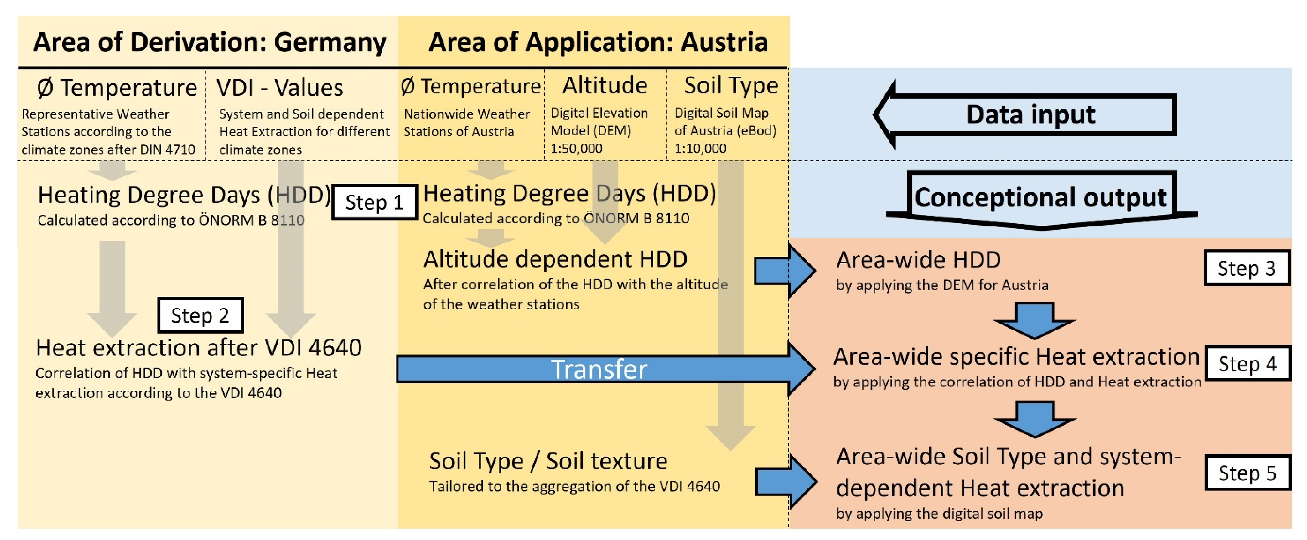
2.1. Data Sources

The first step was defining and obtaining all necessary data sources and realization tools. As a fundamental parameter for the study, heat extraction estimations from VDI 4640 Part 2 [27] were obtained. This report offers heat extraction rates for 5 very shallow geothermal systems, appropriate for 15 different climate zones and 4 different soil types.
The geothermal systems considered are horizontal ground heat exchangers, capillary tube mats, trench collectors, and geothermal baskets with a geometry of 1.3 × 1.3 m (heat basket 1) and a geometry of 2.0 × 0.5 m (heat basket 2). For the purpose of the usage of meteorological statistics and climate data for calculating energy demands of buildings in the standard DIN 4710 [28], Germany is divided into 15 climate zones; each zone is represented by a single weather station: Bremerhaven, Rostock, Hamburg, Potsdam, Essen, Bad Marienberg, Kassel, Braunlage, Chemnitz, Hof, Fichtelberg, Mannheim, Passau, Stötten, and Garmisch-Partenkirchen (Table A1). In VDI 4640, stated heat extraction rates also depend on soil type. Four major soil types are considered: sand, loam, silt, and sandy clay. Sandy clay is a specific soil type that represents close to ideal soil properties regarding geothermal applications with optimal thermal conditions. According to VDI 4640, this specific soil type allows significantly higher and more optimistic heat extraction rates compared to the three other soil types. By applying a spatial investigation as in this study, with areal data of various resolutions and performed interpolation, an exact determination of a specific soil type is hard to guarantee. Therefore, we decided to exclude sandy clay from this concept to avoid an overestimation of the transferred heat extraction rates.
As mentioned, the goal of this study is to develop a method to transfer heat extraction rates specified for Germany (area of derivation) to other geographical areas (area of application), and to test it in two federal states of Austria: Salzburg and Styria (Figure 1). Hence, specific data related to the case study areas are necessary (Table A2).
The parameters relevant for this study, which are specific for the investigated geographical area, are altitude, soil type, and mean ambient temperature. Mean ambient temperature is essential, because the annual mean value represents undisturbed soil temperature, and it defines the heating demand for buildings. The digital elevation model (DEM) [30] of Austria is provided (Figure 2) to achieve information regarding altitudes as a proxy for these mean ambient temperatures. The model’s horizontal resolution is 50 × 50 m (50 m), and its vertical resolution is 0.1 m. Soil maps of Salzburg and Styria (scale bar 1:10,000) [31] are also required to specify the relevant soil type. While the DEM was readily accessible online, the soil maps were bought and provided by the Geological Survey of Austria.
Ambient air temperature is a crucial variable for considering heating demand by applying HDDs. Therefore, average monthly ambient air temperatures for Germany and Austria are obtained.
For Germany, temperature values are obtained from DIN 4710 [28]. This standard presents average monthly ambient temperatures for the 15 weather stations that represent the used climate zones referenced in VDI 4640. The implemented monthly mean values were determined by using mean temperatures for the period of 30 years (1961–1990). The database is narrowed to two weather stations, where a shorter period of observation is noted: Marienberg (from 1963) and Chemnitz (from 1977). Nonetheless, these periods are sufficient to serve as a meaningful database.
Average monthly ambient temperature values for Austria are obtained from the web presentation of the national meteorological and geophysical service of Austria, the Central Institute for Meteorology and Geodynamics [32]. This source offers average monthly ambient temperatures for 30 weather stations in Austria that are spread over the entire country and located at different elevations. Mean monthly temperatures are taken for the observed period of 30 years (1981–2010). Daily ambient air temperatures would be more precise, but since daily as well as monthly temperature values are determined by using data of a 30-year period, the difference should be negligible.
The geographic information system (GIS) software ArcGIS is applied for mapping, as well as for the intersection between numerical and areal databases, and for the implementation of soil maps.

2.2. Adaption Process

The adaption process (Figure 3) includes the calculations of HDD based on the average monthly ambient air temperatures for the area of derivation and area of application, as well as several correlations which are explained below, to produce an area-wide heat extraction map for the area of application.

2.2.1. STEP 1—Definition of HDD

Calculating the HDD values is an important step for transferring heat extraction rates in the study. Degree day is a general number of days in which the temperature moves below or above a defined threshold, and HDD is used to define the heating energy demand of buildings [33]. There are different ways to calculate HDD. For the purpose of this study, the applied Equation (1) is available in Austrian Standards International ÖNORM B 8110-5 [34]:
HDD22/14 = ∑ (Tin − Tout) × d,
where:
  • HDD22/14   represents the heating degree days according to ÖNORM B 8110-5;
  • Tin   is the average inside temperature, which is defined as 22 °C;
  • Tout   is the average outside temperature of the respective month (in °C); and
  • d   is the number of days in the respective month when ambient T < 14 °C.
It is important that HDDs are calculated using the same principle for both the initial and reliant country (i.e., the area of derivation and area of application). In this study, HDDs are calculated for 15 weather stations from Germany, as well as for 30 weather stations in Austria, according to Equation (1).

2.2.2. STEP 2—Correlation of Heat Extraction Rate with HDD (Area of Derivation)

In the next step, the first correlations are introduced in preparation for the transfer of the heat extraction rate from the area of derivation as provided in VDI 4640 Part 2 [27]. Therefore, heat extraction is correlated with the calculated HDDs. This correlation is drawn for 15 German weather stations considering the respective soil types and the different very shallow geothermal systems of VDI 4640. This relation is needed for transfer heat extraction rates as stated in VDI 4640, which are calibrated on the respective German weather stations, to other study areas outside of Germany. Due to the availability of ambient temperature data for calculation HDDs, this parameter is used as a transfer medium for referring the heat extraction rates to another region.

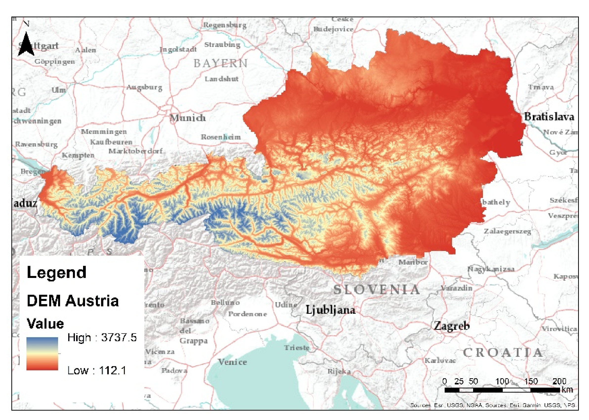
2.2.3. STEP 3—Correlation of HDD with altitude (Area of Application)

This step excludes the area of derivation (Germany) and focuses on the area of application (in this case, Austria). As the HDDs were similarly calculated for Austrian weather stations, in this step, they are correlated with the respective altitude of the 30 weather stations. This correlation enables a continuous coherence that is applied on the DEM of Austria. Combining this correlation and the DEM of Austria allows a map of altitude-dependent HDDs as an extrapolation of the HDDs to the whole country. An area-wide HDD value map for the whole study area in Austria was produced by utilizing a GIS project.

2.2.4. STEP 4—Transfer of Heat Extraction to Area of Application

After performing STEP 1 (calculating the HDD values) and STEP 2 (correlations of heat extraction with HDD), heat extraction rates can be determined for any given HDD. To transfer these relations to the area of application, an HDD map of the study area in Austria was compiled (STEP 3). To generate an initial map of the heat extraction rates for the area of application, the derived correlations of STEP 2 were applied to this spatial HDD map.

2.2.5. STEP 5—Consideration of Soil Map Information
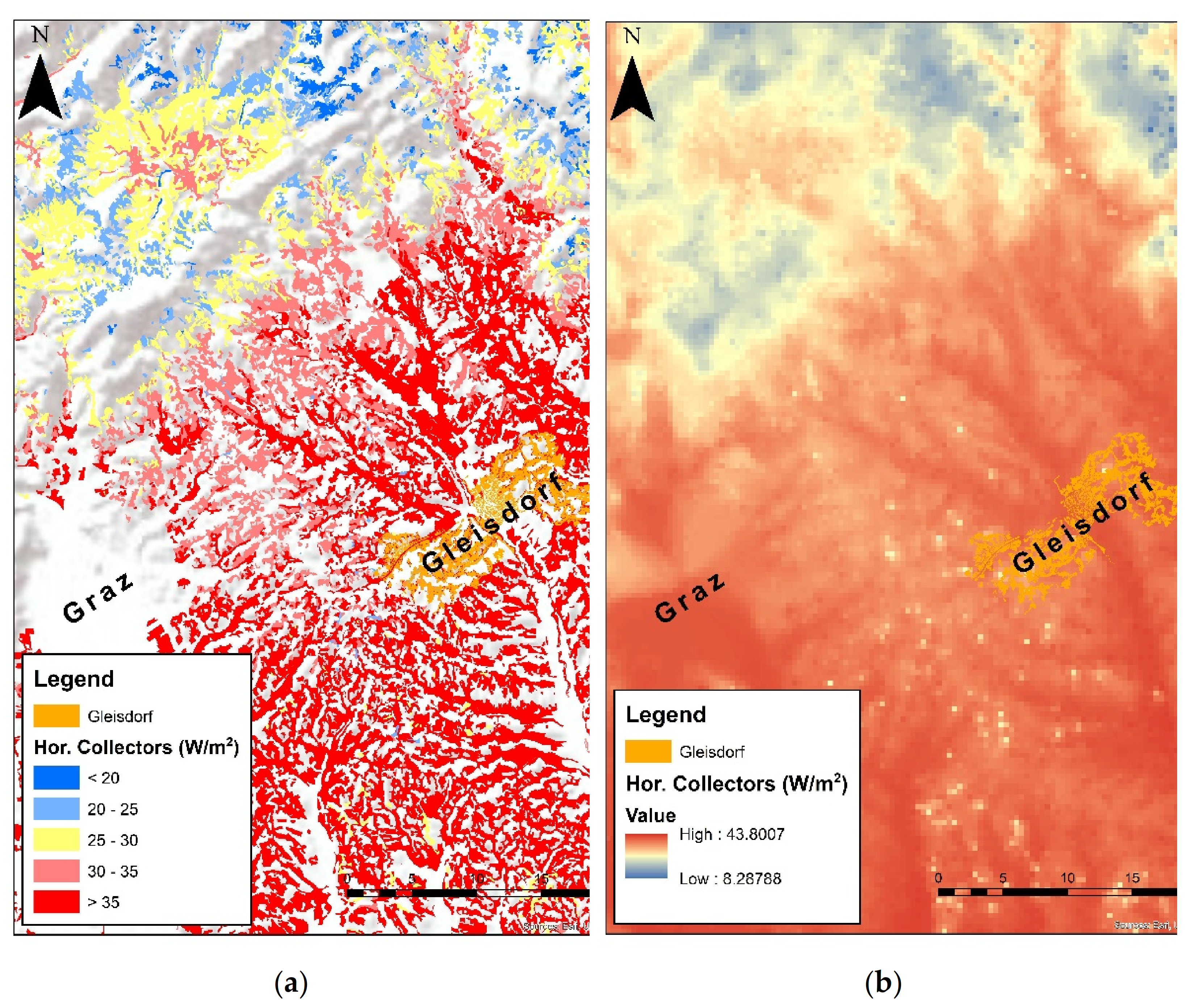
The last step involves the soil map for the study area. Before this step, the heat extraction rate in one point was available for all in VDI 4640 stated soil texture groups, but without reference to one respective soil texture group, and it depended solely on HDD. The relevant soil texture groups were identified in the spatial data set for the study area and partly re-categorized to fit the soil types mentioned in VDI 4640 Part 2 (Table A3). As a result, it is possible to narrow heat extraction values by dependency on VDI 4640 soil types: sand, loam, or silt [27]. Thus, for the area of application, a map of potential heat extraction rates for different very shallow geothermal systems depending on soil texture, altitude, and climate can be produced. Firstly, the spatial outcomes follow the polygons of the digital Austrian soil map. To produce total coverage, soil texture information needs to be interpolated. Therefore, the three grain size fractions, sand, silt, and clay (Table A3), were used, and the inverse distance weighting (IDW) method was applied.

3. Results

In STEP 1, the HDDs for both areas (area of derivation and area of application) were determined according to ÖNORM B 8110. These calculated annual HDD values range from about 3500 to 7000 in Germany and from about 3500 to 10,000 in Austria. The difference regarding the latter end of HDD numbers is due to the altitude of the respective weather stations. In Germany, the highest weather station, which is used as a representative weather station for the climate zones according to DIN 4710, is 1213 m above sea level, whereas in Austria, there are a few weather stations that are up to 3105 m above standard elevation zero. Within such heights, HDDs are elevated, as well.
To compile area-wide specific heat extraction values based on this HDD map for the area of application, a correlation between HDD and heat extraction of each very shallow geothermal system and for every respective soil type group according to VDI 4640 (STEP 2) must be performed for the climate zones of Germany (area of derivation). With this advance, a system characteristic and soil-specific correlation between HDD and heat extraction is defined (Figure 4).
Because these correlations were performed for three soil type groups and for all five shallow geothermal systems considered by VDI 4640 Part 2, in total, 14 such relations were established (Figure 5). Regarding the trench collector, the values for loam and silt are equivalent. Otherwise, there would be 15 relations.
The coefficients of determination for those relations are in the range R² = 0.74–0.93 (Figure 5a–n).
By introducing the correlations between HDD and the heat extraction rate, the key parameter is prepared for application on any other area of investigation. Therefore, this information must be transferred to the area of application by calculating heat extraction with all 14 relations (Table 1) using the specific HDD of the study area.
The altitude is used as a proxy for mean ambient temperatures to enable an area-wide transfer of the target parameter. The dependency of altitude on HDD is showcased by the correlation between the previously calculated HDD and the altitude of the respective weather stations (Figure 6). With R² = 0.97, an unambiguous coherence between HDDs and the altitude was found. As a result, the HDD values for a distinct region can be determined just by using the altitude (h) and the determined area-specific correlation trend (2). This relation is only valid regarding the area of application, in this case for Austria. For other countries, this coherence according to STEP 3 must be determined separately.
HDD22/14 = 2.1227 × h + 2994.8
With the knowledge of this relation (Figure 6), the HDD value, which had been primarily punctual information related to each weather station, is rolled out over the whole investigated area (Austria) by applying the relation to the DEM of the country. Therefore, the introduced Equation (2) is used for the GIS project to calculate the georeferenced HDD with the DEM information for the area of application.
For this study, the area of application is defined by the Austrian federal states of Salzburg and Styria. Therefore, the specific HDD was prepared in the GIS as an area-wide map for both federal states. On that basis, the stated relations between HDD and heat extraction rates (Table 1, Figure 5) could be used for an area-wide calculation of the specific heat extraction in this GIS project (STEP 4).
In this processing stage, the heat extraction rate for each shallow geothermal system is available over the whole area for all three applied soil texture groups. Thus, the corresponding soil map was implemented to determine the actual present soil texture group and the corresponding heat extraction rate (STEP 5). After this implementation, the potential heat extraction rate could be mapped for the area of application (Salzburg and Styria) for the different very shallow geothermal systems covered by VDI 4640 (Figure 7). It is shown in Figure 5 and Figure 7 that trench collectors have the highest extraction rates and heat baskets have the lowest extraction rates. Furthermore, the figures show the influence of climate conditions induced by altitude.
By zooming in on the produced potential map, it is apparent that the application of the concept in this spatial context of the GIS project follows the polygons of the Austrian soil map (Figure 8a).
Due to missing soil data for built-up, forest, and mountainous areas, in this study, the given soil information is interpolated using the IDW method. By using the interpolated soil type information, a total coverage of the investigated area regarding the specific heat extraction rate is possible (Figure 8b).
In the depicted heat extraction map, the effect of the DEM is obvious. The heat extraction values are higher in the valleys and the promontory plains, whereas the more mountainous areas show decreased heat extraction.
Thus, by applying the introduced concept (Figure 3; STEP 1–STEP 5) with the respective calculation models (Table 1), the specific heat extraction values for very shallow geothermal systems are estimated based on the characteristic HDD of the study area in Austria. Furthermore, this concept is also applicable in any other area of application where climate data (monthly or daily ambient temperature), a soil map, and a DEM are available.

4. Discussion

Due to the lack of reliable information regarding precise heat extraction over a variety of different very shallow geothermal systems and its dependence on the spectrum of soil types, the application of VDI 4640 might be the only way to describe such a specific potential map. Therefore, it should be kept in mind that the declaration in the guideline was previously empirical (the 2001 version) and was improved by numerical modeling and simulations [29] in the 2019 version. Nonetheless, VDI 4640 Part 2 constitutes a source of information that is frequently used by planners of very shallow geothermal installations in and outside of Germany.
With regard to the correlation between HDDs and altitude for the region of Austria, an unambiguous coherence (R² = 0.97) was found (Figure 6). However, it should be noted that due to the restricted availability of climate data in Austria, mean monthly ambient temperatures could have been used for determining HDDs for one averaged year. Usually, mean daily values are preferred, but considering that a monthly mean is based on daily values, it should lead to very similar results.
To derive a meaningful relation between HDDs and altitude as stated in Equation (2), it is helpful to have recourse to a data basis provided by weather stations that are spread over a distinct range of altitude. If all considered weather stations are at one elevation level, no significant trend can be revealed. In the prepared case, Austria features weather stations over a wide elevation range.
Generally, climate conditions (or rather, the ambient temperature considered for this study) should follow the elevation. However, although this is an anticipated result, it still has strong coherence with the mentioned discussion points as well as the extent of the investigated area of application.
Since HDDs are used in the concept, there are two further points that should be taken into account. One point is that HDDs are often determined in a way that is individually customized for each country. The Equation (1) used in this study presents the Austrian methodology [34]. In this case, this method was preferred because of the focus of this study area, but many other countries have their own elaborated methods [35,36,37]. This shows that there is a lack of an international methodology [38]. Hence, by applying the concept as carried out in this study on other regions, the basis is still the Austrian methodology. If other national or international HDD methods are to be integrated, the concept will have to be processed from STEP 1 with an adjusted Equation (1).
The other point is that by applying an HDD method as in the presented concept, only heating demand is considered. For low-energy buildings and for application in warmer regions, it would be worth considering cooling by implementing cooling degree days [39,40] for future approaches. Cooling has enormous potential especially for very shallow geothermal installations, due to their characteristic possibility of a mutual usage (cooling and heating).
To meet the heating demand defined by the HDDs, the necessary and possible heat extraction rate must be determined. Therefore, correlations were established for all investigated shallow geothermal systems and for the main soil texture groups—sand, loam, and silt—that are treated by VDI 4640 Part 2. Unfortunately, a more diverse soil type range is not available, which may have led to a more sophisticated result. However, with this given structure, coarse-grained as well as fine-grained soil are still taken into account.
Regarding the correlations between HDDs and heat extraction rates, the calculated heat extraction rates are significantly lower for sand than for loam and silt (Figure 5). The difference between loam and silt is minor, but overall, silt exhibits the highest heat extraction values. This outcome follows, for instance, a study by Busby et al. [41], where dry sand had the least thermal conductivity and silt had the highest thermal conductivity values. Pure sand showing very low heat extraction values is comprehensible because of its low water holding capacity; thus, the thermal connectivity can be notably diminished [42]. Busby et al. showed that only values for saturated soil exceed the thermal conductivity of silt. Regarding saturated conditions, the thermal conductivity trend is the opposite, and sand shows the highest values [15]. Regarding very shallow geothermal applications, (continuous) saturated soil conditions should not be assumed because of the very shallow installation depth. For this study (in terms of potential heat extraction stated in VDI 4640), the most optimistic soil type sandy clay was excluded in order to avoid overestimations. This indicates that in VDI 4640, a soil consisting of sand with a fine-grained addition has more beneficial thermal conditions like silt has. A higher thermal conductivity for a sandy soil also corresponds to the outcomes of Markert et al. [43].
Thermal properties of soil are difficult to handle due to the dependencies on other varying physical soil parameters. The possible variations of actual thermal properties in one soil can differ distinctly [13] by variations of water content [14], the volume fraction of air [7], and bulk density [8,12,18]. When applying VDI 4640 as a data source, these soil parameters cannot take such variations into consideration. However, for this study, only a general outline is necessary to enable such a spatial analysis.
In this study, the correlations between HDDs and the heat extraction rates for the respective soil types are in the range R² = 0.74–0.93 (Figure 5). Because HDDs that are defined by climatic conditions (ambient temperatures) are correlated with heat extraction rates defined for different climate zones, suitable coherence is expected to some degree. If this concept is applied in other countries or areas with more divergent climate conditions, these correlations between HDDs and heat extraction rates can differ more.
Considering each system, the coefficients of determination average around R² = 0.91 for the classical horizontal collector and the capillary tube mats, whereas the coefficients for both heat baskets are around R² = 0.80 and that for the trench collector is about R² = 0.77. The two systems with a higher coherence (horizontal collectors and capillary tube mats) show a wider range of heat extraction rates in one correlation (Figure 5a–f) than heat baskets and trench collectors (Figure 5g–n). These more exponential trends with a wider range of heat extraction might produce higher coefficients of determination than the very flat and nearly linear trends of heat baskets and trench collectors, although the overall deviations are very similar.
This finding also means that capillary tube mats and horizontal collectors, as more areal systems, are more affected by climatic conditions than the other investigated very shallow geothermal systems. The reason for this might be found in the boundary conditions of the numerical modeling, but an appropriate reference that would prove this statement is unknown.
Regarding the coefficients of determination, it must be considered that in this case, the established correlations between HDDs and heat extraction rates show just one point beyond 5364 HDDs. This one point at 6946 HDDs has a strong effect on the trend of the correlations. However, due to the fact that these basis values are not measured but given by the applied standard, the determined relations should be reliable. Still, there is an uncertainty, especially for HDD values of the study area that exceed this last HDD point. Particularly, if this concept is applied in regions with few weather stations or with weather stations that are allocated only at lower elevations even though there are mountainous areas, the application of this relation will exceed the highest HDD data point.
However, this correlation between HDDs and heat extraction rates is essential for the transfer of heat extraction from German climate zones to Austrian ambient temperatures. Only by such a transfer, an application of the specific heat extraction rates of VDI 4640 Part 2 for other regions in terms of potential maps is possible. Values of VDI 4640 are already widely used by planners in the first appraisal for new shallow geothermal installations, although until now, there were only 15 climate zones and no gradual transition available. Thus, by applying the approach of this study, the utility of the already given information in a gradual and spatial form is significant. In the GEL-SEP project itself, the goal is to raise policy makers’ awareness of vSGPs, but these potential maps will also help planners make more appropriate assessments.

5. Conclusions

Applying the presented concept is an opportunity to extract and provide system-specific heat extraction rates for very shallow geothermal ground-loop systems in spatial potential maps. The area-wide provision of this information can be useful for planners who consider ground source heat pump systems and for policy makers who want to utilize the general potential of very shallow geothermal systems.
Since the specific heat extraction rates for very shallow geothermal systems from VDI 4640 Part 2 are linked to defined German climate zones, the direct application of this VDI 4640 guideline was not possible elsewhere. This study’s introduced concept enables a mapping of system-specific heat extraction values according to VDI 4640 on other study areas outside of Germany. In this study, the concept was performed on a study area in Austria.
Therefore, the correlation between the calculated HDD and the altitude of the respective weather stations in Austria was at a high level (R² = 0.97). For the next step, the direct relations between the HDD and the soil-specific heat extraction values of the area of derivation were needed to apply these to the study area. The relations developed in this study are in the range R² = 0.74–0.93. Considering each system, these coefficients of determination average around R² = 0.84. These correlations constitute the basis for an application of this concept in the study area. With regard to these coefficients of determination, the transfer of the climate zone-dependent, system-specific heat extraction values to the study area by applying the introduced concept was successful. However, to evaluate whether the heat extraction arrangement corresponds to actual existing conditions, a validation is necessary.
Furthermore, this concept applied to the area of application in Austria is also transferable to other countries with similar climate conditions to Germany, most likely by reaching a similar transfer quality. After defining the HDDs of the application area, only STEP 3–STEP 5 must be carried out. The only requirements that must be considered are the availability of monthly or better daily ambient temperatures including the altitude of the weather stations, a soil map, and a DEM of the area of application. With these three inputs, the transfer to other countries with temperate climate conditions is to be expected with high accordance. A transfer to other areas with sub-arid or arid climates or to areas with frozen soils will not be directly possible, because additional aspects regarding pedological conditions and the heating and cooling demands will differ. Within the boundary conditions of the numerical modeling by Ramming [29], these aspects are not considered to their full extent. Thus, VDI 4640 Part 2 [27] as a source of heat extraction rates may not be entirely appropriate for significantly deviating global climate zones.
Nevertheless, with such a tool, by enabling the provision of widespread and georeferenced heat extraction information for specific very shallow geothermal systems, an easier application of these systems across countries may result. Information about the heat extraction rate, especially for planners and installers, might facilitate the utilization of very shallow geothermal systems.
This concept provides a solid workflow that can be applied to other study areas. For very large countries and study areas, it might be expedient to perform the correlations for different regions separately, considering that empirical values from actual very shallow geothermal installations are needed in these study areas to validate the concept.

References

Author Contributions

Conceptualization, H.S. and N.J.; methodology, H.S.; software, N.J.; validation, H.S. and N.J.; formal analysis, H.S.; investigation, H.S.; resources, D.B.; data curation, N.J. and H.S.; writing—original draft preparation, H.S. and N.J.; writing—review and editing, D.B., N.J. and H.S.; visualization, N.J. and H.S.; supervision, D.B.; project administration, D.B.; funding acquisition, D.B. All authors have read and agreed to the published version of the manuscript.

Funding

This research was partly funded through a subcontract with the Geological Survey of Austria in the course of the project “Green Energy Lab-Spatial Energy Planning”. For publication we acknowledge financial support by Deutsche Forschungsgemeinschaft and Friedrich-Alexander-Universität Erlangen-Nürnberg within the funding programme “Open Access Publication Funding”.

Institutional Review Board Statement

Not applicable.

Informed Consent Statement

Not applicable.

Data Availability Statement

Not applicable.

Acknowledgments

The authors want to thank colleagues from the Geological Survey of Austria, Cornelia Steiner and Gregor Götzl, for considering us for the implementation of the very shallow geothermal portion of the project “Green Energy Lab-Spatial Energy Planning” and the provision of the soil maps of the study area.

Conflicts of Interest

The funders had no role in the design of the study; in the collection, analyses, or interpretation of data; in the writing of the manuscript, or in the decision to publish the results.

Appendix A

Table A1. List of German weather stations used (according to DIN 4710 [28]).
NR.LocalityAltitude (Average of DIN 4710-Stated Values) (m ASL)Respective Climate Zone
1Bremerhaven/Norderney18(1) Bremerhaven
2Rostock-Warnemünde/Heiligendamm13(2) Rostock-Warnemünde
3Hamburg-Fuhlsbüttel/Hamburg-Sasel31(3) Hamburg-Fuhlsbüttel
4Potsdam81(4) Potsdam
5Essen/Gelsenkirchen/Bochum134(5) Essen
6Bad Marienberg/Bad Lippspringe355(6) Bad Marienberg
7Kassel231(7) Kassel
8Braunlage607(8) Braunlage
9Chemnitz418(9) Chemnitz
10Hof/Zinnwald722(10) Hof
11Fichtelberg1213(11) Fichtelberg
12Mannheim96(12) Mannheim
13Passau409(13) Passau
14Stötten/Stuttgart-Schnarrenberg526(14) Stötten
15Garmisch-Partenkirchen596(15) Garmisch-Partenkirchen
Table A2. List of Austrian weather stations used (according to ZAMG [32]).
NR.LocalityAltitude (m ASL)
1Bad Gleichenberg282
2Bregenz424
3Eisenstadt184
4Feuerkogel1618
5Graz-Uni366
6Hohenau/March155
7Innsbruck-Uni581
8Irdning-Gumpenstein707
9Klagenfurt448
10Kresmünste383
11Kufstein495
12Langen am Arlberg1250
13Lienz659
14Linz-Stadt263
15Loibl-Tunnel1092
16Obergurgl1938
17Patscherkofel2247
18Reutte852
19Ried im Innkreis435
20Salzburg-Flughafen430
21Schöckl1436
22Sonnblick3105
23St. Pölten260
24St. Sebastian-Mariazell872
25Tamsweg1024
26Villacher Alpe2160
27Wien-Hohe Warte200
28Zell am See766
29Zeltweg677
30Zwettl-Stift506
Table A3. Soil types of the Austrian soil map with their respective grain size fractions used in this study for IDW interpolation and the major soil texture groups that correspond to VDI 4640 Part 2.
Major Soil Texture Groups Applied in VDI 4640 Part 2Soil Types of the Austrian Soil ClassificationSilt%Clay%Sand%
SandSand (S) 15580
SandSilty Sand (uS) 42.52.555
LoamLoamy Sand (lS)37.51052.5
SiltSandy Silt (sU)651025
SiltSilt (U)85105
LoamClayey Sand (tS)517.577.5
LoamSandy Loam (sL)37.52042.5
SiltLoamy Silt (lU)652015
LoamSandy Clay (sT)532.562.5
LoamLoam (L)37.532.530
SiltSilty Loam (uL)65305
SiltLoamy Clay (lT)27.54527.5
SiltClay (T)25750

References

  1. European Commission 2015–2021: Heating and Cooling. Available online: https://ec.europa.eu/energy/topics/energy-efficiency/heating-and-cooling_en (accessed on 5 January 2022).
  2. Haehnlein, S.; Bayer, P.; Blum, P. International legal status of the use of shallow geothermal energy. Renew. Sust. Energ. Rev. 2010, 14, 2611–2625. [Google Scholar] [CrossRef]
  3. Goldbrunner, J. Oberflächennahe Geothermie in Österreich. In Handbuch Oberflächennahe Geothermie, 1st ed.; Bauer, M., Freeden, W., Jacobi, H., Neu, T., Eds.; Springer: Berlin/Heidelberg, Germany, 2018; pp. 739–753. [Google Scholar]
  4. Bertermann, D.; Klug, H.; Morper-Busch, L.; Bialas, C. Modelling vSGPs (very shallow geothermal potentials) in selected CSAs (case study areas). Energy 2014, 71, 226–244. [Google Scholar] [CrossRef]
  5. Jocić, N.; Müller, J.; Požar, T.; Bertermann, D. Renewable Energy Sources in a Post-Socialist Transitional Environment: The Influence of Social Geographic Factors on Potential Utilization of Very Shallow Geothermal Energy within Heating Systems in Small Serbian Town of Ub. Appl. Sci. 2020, 10, 2739. [Google Scholar] [CrossRef] [Green Version]
  6. Zeh, R.; Ohlsen, B.; Philipp, D.; Bertermann, D.; Kotz, T.; Jocić, N.; Stockinger, V. Large-Scale Geothermal Collector Systems for 5th Generation District Heating and Cooling Networks. Sustainability 2021, 13, 6035. [Google Scholar] [CrossRef]
  7. Ochsner, T.E.; Horton, R.; Ren, T. A new perspective on soil thermal properties. Soil Sci. Soc. Am. J. 2001, 65, 1641–1647. [Google Scholar] [CrossRef]
  8. Abu-Hamdeh, N.H. Thermal properties of soils as affected by density and water content. Biosyst. Eng. 2003, 86, 97–102. [Google Scholar] [CrossRef]
  9. Schwarz, H.; Bertermann, D. Mediate relation between electrical and thermal conductivity of soil. Geomech. Geophys. Geo-Energy Geo-Resour. 2020, 6, 50. [Google Scholar] [CrossRef]
  10. Côté, J.; Konrad, J.M. A generalized thermal conductivity model. Can. Geotech. J. 2005, 42, 443–458. [Google Scholar] [CrossRef]
  11. Barry-Macaulay, D.; Bouazza, A.; Singh, R.M.; Wang, B.; Ranjith, P.G. Thermal conductivity of soils and rocks from the Melbourne (Australia) region. Eng. Geol. 2013, 164, 131–138. [Google Scholar] [CrossRef] [Green Version]
  12. Lu, Y.; Lu, S.; Horton, R.; Ren, T. An empirical model for estimating soil thermal conductivity from texture, water content, and bulk density. Soil Sci. Soc. Am. J. 2014, 78, 1859–1868. [Google Scholar] [CrossRef]
  13. Bertermann, D.; Schwarz, H. Laboratory device to analyse the impact of soil properties on electrical and thermal conductivity. Int. Agrophys. 2017, 31, 157. [Google Scholar] [CrossRef] [Green Version]
  14. Lu, S.; Lu, Y.; Peng, W.; Ju, Z.; Ren, T. A generalized relationship between thermal conductivity and matric suction of soils. Geoderma 2019, 337, 491–497. [Google Scholar] [CrossRef]
  15. Bertermann, D.; Müller, J.; Freitag, S.; Schwarz, H. Comparison between measured and calculated thermal conductivities within different grain size classes and their related depth ranges. Soil Syst. 2018, 2, 50. [Google Scholar] [CrossRef] [Green Version]
  16. Bertermann, D.; Klug, H.; Morper-Busch, L. A pan-European planning basis for estimating the very shallow geothermal energy potentials. Renew. Energ. 2015, 75, 335–347. [Google Scholar] [CrossRef]
  17. Di Sipio, E.; Bertermann, D. Factors influencing the thermal efficiency of horizontal ground heat exchangers. Energies 2017, 10, 1897. [Google Scholar] [CrossRef] [Green Version]
  18. Abu-Hamdeh, N.H.; Reeder, R.C. Soil thermal conductivity effects of density, moisture, salt concentration, and organic matter. Soil Sci. Soc. Am. J. 2000, 64, 1285–1290. [Google Scholar] [CrossRef]
  19. Zhu, D.; Ciais, P.; Krinner, G.; Maignan, F.; Puig, A.J.; Hugelius, G. Controls of soil organic matter on soil thermal dynamics in the northern high latitudes. Nat. Commun. 2019, 10, 3172. [Google Scholar] [CrossRef] [Green Version]
  20. Martinopoulos, G.; Papakostas, K.T.; Papadopoulos, A.M. A comparative review of heating systems in EU countries, based on efficiency and fuel cost. Renew. Sust. Energ. Rev. 2018, 90, 687–699. [Google Scholar] [CrossRef]
  21. Pu, L.; Xu, L.; Qi, D.; Li, Y. Structure optimization for horizontal ground heat exchanger. Appl. Therm. Eng. 2018, 136, 131–140. [Google Scholar] [CrossRef]
  22. Yan, T.; Xu, X. Utilization of Ground Heat Exchangers: A Review. Curr. Sustain. Renew. Energy Rep. 2018, 5, 189–198. [Google Scholar] [CrossRef]
  23. Boban, L.; Miše, D.; Herceg, S.; Soldo, V. Application and Design Aspects of Ground Heat Exchangers. Energies 2021, 14, 2134. [Google Scholar] [CrossRef]
  24. Müller, J.; Galgaro, A.; Dalla Santa, G.; Cultrera, M.; Karytsas, C.; Mendrinos, D.; Pera, S.; Perego, R.; O’Neill, N.; Pasquali, R.; et al. Generalized pan-European geological database for shallow geothermal installations. Geosci. J. 2018, 8, 32. [Google Scholar] [CrossRef] [Green Version]
  25. Ramos-Escudero, A.; García-Cascales, M.S.; Cuevas, J.M.; Sanner, B.; Urchueguía, J.F. Spatial analysis of indicators affecting the exploitation of shallow geothermal energy at European scale. Renew. Energ. 2021, 167, 266–281. [Google Scholar] [CrossRef]
  26. Assouline, D.; Mohajeri, N.; Gudmundsson, A.; Scartezzini, J.L. A machine learning approach for mapping the very shallow theoretical geothermal potential. Geotherm. Energy 2019, 7, 19. [Google Scholar] [CrossRef] [Green Version]
  27. VDI. VDI 4640-2—Technical Rule 4640-2, Thermal Use of the Underground, Ground Source Heat Pump Systems; VDI, Beuth Publishing House: Berlin, Germany, 2019. [Google Scholar]
  28. DIN. DIN 4710, Statistics on German Meteorological Data for Calculating the Energy Requirements for Heating and Air Conditioning Equipment; DIN, Beuth Publishing House: Berlin, Germany, 2003. [Google Scholar]
  29. Ramming, K. Bewertung und Optimierung Oberflächennaher Erdwärmekollektoren für Verschiedene Lastfälle. Ph.D. Thesis, Technische Universität Dresden, Dresden, Germany, 26 April 2007. [Google Scholar]
  30. Digitales Geländemodell von Österreich, Version 50 Meter. Available online: http://data.opendataportal.at/dataset/dgm-austria (accessed on 20 November 2020).
  31. Digitale Bodenkarte Österreich, eBod. Available online: https://bodenkarte.at/#/center/ (accessed on 20 November 2020).
  32. Zentralanstalt für Meteorologie und Geodynamik—(ZAMG). Klimamonitoring. Available online: https://www.zamg.ac.at/cms/de/klima/klima-aktuell/klimamonitoring/?station=19204&param=t&period=period-ym-2020-01&ref=3 (accessed on 21 December 2020).
  33. Spinoni, J.; Vogt, J.; Barbosa, P. European degree-day climatologies and trends for the period 1951–2011. Int. J. Climatol. 2015, 35, 25–36. [Google Scholar] [CrossRef] [Green Version]
  34. Austrian Standards International. ÖNORM B 8110-5; Thermal Insulation in Building Construction—Part 5: Model of Climate and User Profiles. Austrian Standards International: Vienna, Austria, 2019.
  35. Castañeda, M.E.; Claus, F. Variability and trends of heating degree-days in Argentina. Int. J. Climatol. 2013, 33, 2352–2361. [Google Scholar] [CrossRef]
  36. Janković, A.; Podraščanin, Z.; Djurdjevic, V. Future climate change impacts on residential heating and cooling degree days in Serbia. Időjárás—Q. J. Hung. Meteorol. Serv. (OMSZ) 2019, 123, 351–370. [Google Scholar] [CrossRef] [Green Version]
  37. Ramon, D.; Allacker, K.; De Troyer, F.; Wouters, H.; van Lipzig, N.P. Future heating and cooling degree days for Belgium under a high-end climate change scenario. Energy Build. 2020, 216, 109935. [Google Scholar] [CrossRef]
  38. Atalla, T.; Gualdi, S.; Lanza, A. A global degree days database for energy-related applications. Energy 2018, 143, 1048–1055. [Google Scholar] [CrossRef] [Green Version]
  39. Roshan, G.R.; Ghanghermeh, A.A.; Attia, S. Determining new threshold temperatures for cooling and heating degree day index of different climatic zones of Iran. Renew. Energ. 2017, 101, 156–167. [Google Scholar] [CrossRef] [Green Version]
  40. Christenson, M.; Manz, H.; Gyalistras, D. Climate warming impact on degree-days and building energy demand in Switzerland. Energy Convers. Manag. 2006, 47, 671–686. [Google Scholar] [CrossRef]
  41. Busby, J.; Lewis, M.; Reeves, H.; Lawley, R. Initial geological considerations before installing ground source heat pump systems. Q. J. Eng. Geol. Hydrogeol. 2009, 42, 295–306. [Google Scholar] [CrossRef]
  42. Roshankhah, S.; Garcia, A.V.; Carlos Santamarina, J. Thermal Conductivity of Sand–Silt Mixtures. J. Geotech. Geoenviron. Eng. 2021, 147, 06020031. [Google Scholar] [CrossRef]
  43. Markert, A.; Bohne, K.; Facklam, M.; Wessolek, G. Pedotransfer functions of soil thermal conductivity for the textural classes sand, silt, and loam. Soil Sci. Soc. Am. J. 2017, 81, 1315–1327. [Google Scholar] [CrossRef]
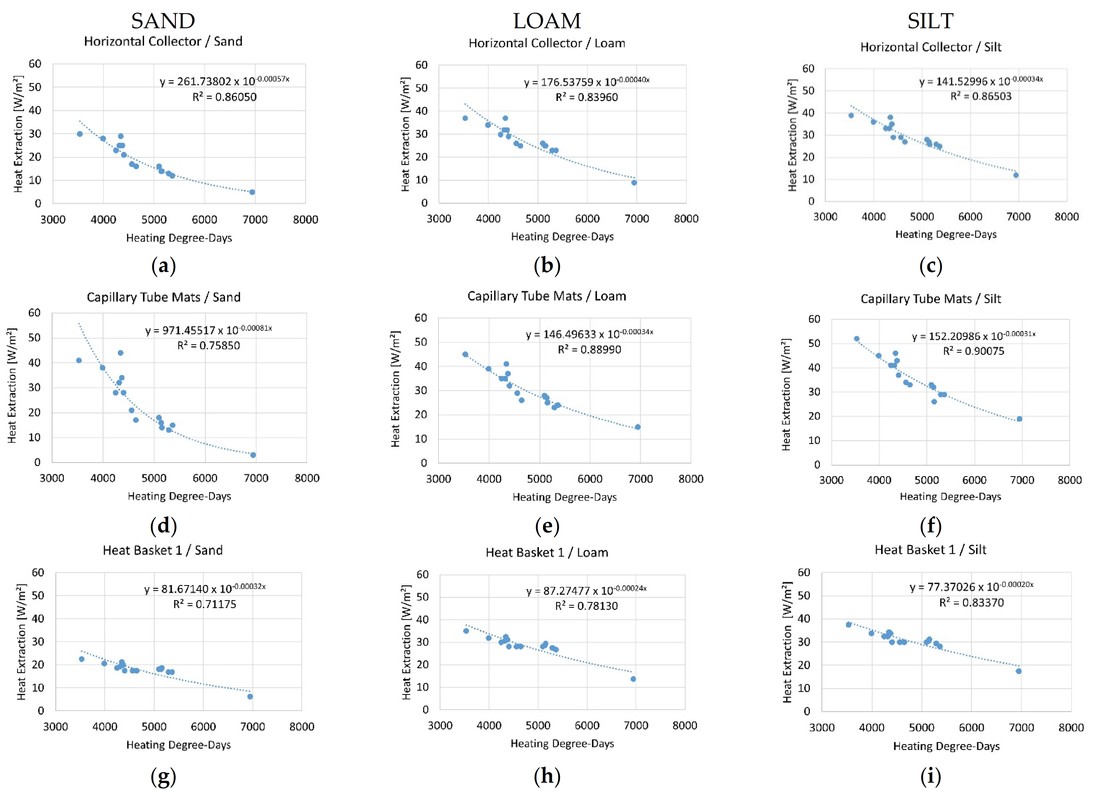
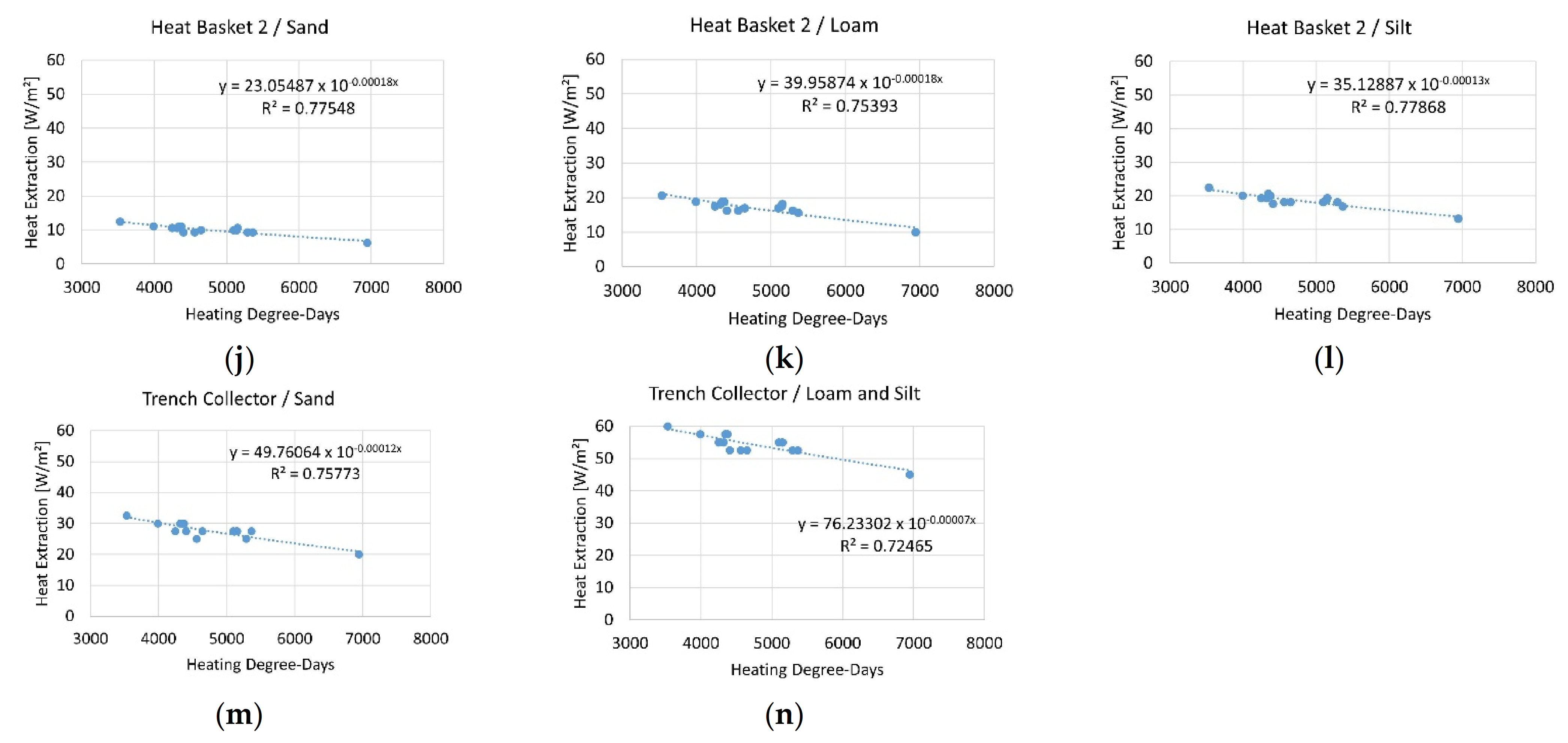
Figure 1. Map of Austria in the European context (small overview picture) with a focus on the two federal states Salzburg and Styria, representing the area of application.
Sustainability 14 04199 g001
Figure 2. DEM of Austria [30] implemented in the geographic information system project.
Sustainability 14 04199 g002
Figure 3. Flowchart of the adaption process.
Sustainability 14 04199 g003
Figure 4. Correlation between HDD and the heat extraction values of VDI 4640 for a horizontal collector in loam soil considering German climate zones after DIN 4710 (STEP 2).
Sustainability 14 04199 g004
Figure 5. (an) Correlation between HDD and the heat extraction values of VDI 4640 for all systems and soil texture groups over the German climate zones after DIN 4710.
Sustainability 14 04199 g005aSustainability 14 04199 g005b
Figure 6. Correlation between HDD and the altitude of the respective weather stations in Austria as described in STEP 3.
Sustainability 14 04199 g006
Figure 7. Maps of heat extraction rates (W/m²) depicted for three very shallow geothermal systems ((A1 + A2): heat basket; (B1 + B2): horizontal collector; (C1 + C2): trench collector) in the area of the Austrian federal states Salzburg (A1 + B1 + C1) and Styria (A2 + B2 + C2).
Sustainability 14 04199 g007
Figure 8. (a) Map of heat extraction rates (W/m²) depicted for the horizontal collector in the area around Gleisdorf (pink area)/Styria/Austria pursuing the polygons of the shapefile of the Austrian soil map. (b) Map of heat extraction rates (W/m²) depicted for the horizontal collector in the area around Gleisdorf/Styria/Austria after interpolation of the soil texture group and following the DEM.
Sustainability 14 04199 g008
Table 1. Developed calculation model for determining heat extraction from HDD.
Very Shallow Geothermal
System
Soil Texture GroupCalculation Model for Heat Extraction (P) Based on HDD (x)Coefficient of Determination
Horizontal
Collector
Sand P = 261.74 10−0.0005667956x [W/m²]R² = 0.94
Loam P = 176.54 10−0.0003992871x [W/m²]R² = 0.89
Silt P = 141.53 10−0.0003357456x [W/m²]R² = 0.90
Capillary Tube Mats Sand P = 971.46 10−0.0008099321x [W/m²]R² = 0.92
Loam P = 146.50 10−0.0003352380x [W/m²]R² = 0.91
Silt P = 152.21 10−0.0003090645x [W/m²]R² = 0.91
Heat Basket 1 Sand P = 81.67 10−0.0003242691x [W/m²]R² = 0.76
Loam P = 87.27 10−0.0002375047x [W/m²]R² = 0.81
Silt P = 77.37 10−0.0001963163x [W/m²]R² = 0.85
Heat Basket 2 Sand P = 23.05 10−0.0001750295x [W/m²]R² = 0.80
Loam P = 39.96 10−0.0001807998x [W/m²]R² = 0.79
Silt P = 35.13 10−0.0001341375x [W/m²]R² = 0.80
Trench
Collector
Sand P = 49.76 10−0.0001244829x [W/m²]R² = 0.78
Loam and SiltP = 76.23 10−0.0000715544x [W/m²]R² = 0.74
Publisher’s Note: MDPI stays neutral with regard to jurisdictional claims in published maps and institutional affiliations.

