

Technologies for the Preservation of Cultural Heritage—A Systematic Review of the Literature

Abstract
:1. Introduction
2. Related Works
3. Methodology
4. Results and Discussion
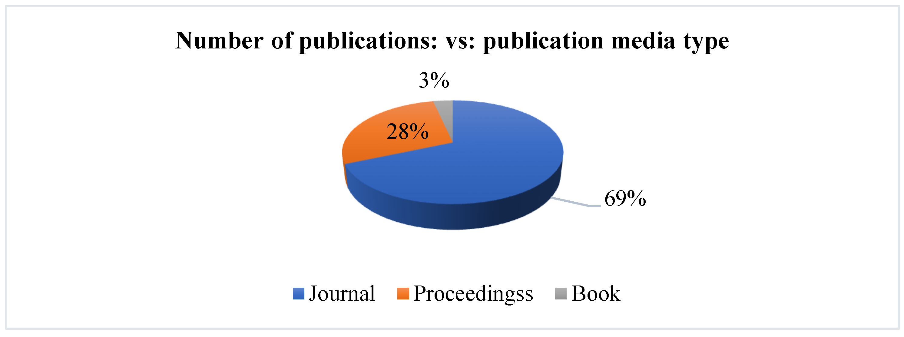
4.1. Scientometric Analysis
4.2. Technical Analysis
5. Conclusions
6. Future Work
Author Contributions
Funding
Institutional Review Board Statement
Informed Consent Statement
Data Availability Statement
Conflicts of Interest
Appendix A

| References | Data Acquisition Methodology | Data Acquisition Technique | Data Acquisition Equipment | Data Processing | End Users |
|---|---|---|---|---|---|
| [37] | Initial modeling (M1): geodetic, photogrammetric and laser scanning data Spectral system: | Photogrammetry Magnetic Scan | M1: Two total integrated stations (Pentax R323NX and Leica TCR 405), two time-of-flight pulse-based 3D laser scanners (Leica BLK 360 and Faro HDR), two full-frame DSLR cameras (Canon EOS 6D and Sony A7RIII) with multiple lenses (24 mm, 135 mm, 28–75 mm) and two unmanned aerial systems (DJI Phantom 4 Pro and Mavic 2 Pro). Hyperspectral: HyperView multi-sensor hyperspectral sensing platform using 3D-one | Software Agisoft Metashape v.1.6.5 Software Geomagic Wrap 2017. Software Faro Scene and Cyclone Register 360 (BLK Edition) applying the Cloud-to Cloud method | Experts |
| [29] | Application of the HeritageCare project with all its protocols (SL1, SL2, SL3) SL1: advanced monitoring system to keep specific structural and environmental parameters under control. | BIM | SL1: 12 temperature and relative humidity (TH), 7 surface and 5 environmental sensors, plus 5 sensors for surface temperature, relative humidity and luminosity (THL). Three xylophagous sensors (X). One carbon dioxide (G) sensor. 2 biaxial clinometers (CL). One weather station (EM) BIM model: Autodesk Revit Virtual Virtualization Tour: HoloLens | HeritageCare Platform Autodesk Revit Software | Experts/Non-experts |
| [27] | The phases of the FEM analysis: (i) construction of the 3D model; (ii) transformation of NIF into a quad mesh model and NURBS; (iii) WEF analysis. Phases of the Photogrammetric Model: (i) alignment of the images; (ii) building of a dense point cloud (PC); (iii) the construction of meshes and the identification of the plans of the single façade; (iv) the construction of the ortho mosaic. | Fotogrametría | Topographic survey: Total station: Leica TS11. EDM measurements are performed using laser technology (Light Amplification by Stimulated Emission of Radiation) Scan to FEMSLR camera. Nikon D3300 with a Nikkor 20mm f/2.8D prime lens. Intel(R) Xeon(R) E5-1650v4 @ 3.60 GHz CPU (central processing unit), RAM (random access memory) 64 GB, NVIDIA Quadro M4000 GPU (graphics processing unit). | Software Rhino Software Cloud Comparison Software Agisoft Metashape Software Midas Fea NX | Experts |
| [30] | Data acquisition (photogrammetry) Information Analysis-3D Modeling Using Analysis Software Calculating the severity index | Fotogrametría | Processing: Computer with dual Intel Xeon processor (128 GB RAM, 64-bit operating system). Standard Level Cameras, Carbon Fiber Telescopic Rod, Tripod, Tablet, Laser Distance Meter, Flexometer, Tweezers | Software Agisoft Photoscan Software 3D microscopy analysis software (such as TalyMap 3D), Microsoft Excel software | Experts |
| [38] | Exhibition platform (mirror) Three-dimensional (3D) scanning to build a digital database of the original shapes. | Optical scanning | High-resolution optical scanner for creating 3D models | 3D printing for scientific exhibition | Non-experts |
| [39] | Implementation of the INCEPTION platform: innovate 3D models “forever”, “for everyone”, “everywhere”, developing, collecting and sharing interoperable 3D semantic models. Cloud-based platform. | BIM | The BIM model allows the use of any software such as Autodesk Revit, ArchiCAD, Apache Fuseki SPARQL Dedicated Server. | Input = BIM model loaded as IFC (Industry Foundation Class) processed under Windows. Semantic information is extracted and generated as (RDF), according to the INCEPTION H-BIM ontology, serialized as Turtle (TTL), stored and accessed as HTTP through a dedicated server. | Experts |
| [35] | A segmentation process was carried out in the chosen sector using the EasyCUBE PRO software of the Geomaticscube Ecosystem (Geomaticscube, 2018) | Software tool called “Working Box” allows you to define the minimum rectangular parallelepiped (box) capable of enclosing a 3D object. | EasyCUBE PRO software from the Geomaticscube ecosystem (Geomaticscube, 2018) | Experts | |
| [40] | Knowledge: 3D Survey Techniques Modeling Methods and modalities of access and web exchange of multiscale 3D reconstructions. | BIM | Online information system, data provided by the Politecnico di Milano. | Modelo 3D: BIM technique. BIM3DSG7:1. Database creation (DB). PostgreSQL Software PgAdmin. | Experts |
| [41] | Application of different data acquisition techniques for 3D modeling and literature analysis to formulate guidelines for the implementation and organization of the BIM and HBIM process for cultural heritage objects | Project 1: Terrestrial laser scanning-Photogrammetry Project 2: Laser scanning Project 3: Photogrammetry Project 4: Laser scanning and photogrammetry BIM | Project 1: Faro X330 ScannerProject 2: Z+ F SCANNER IMAGER 5010cProject 3: NIKON D200 digital camera and AF S NIKKOR objective Project 4: FARO FocuS 150 ground scanner, complemented by drones with 6K Cinema DNGRAW digital cameras. | P1: Autodesk ReCap, AutoCAD, Revit, Meshlab-BIM model: Software: FARO SCANE, Geomagic Design X, Rhino Ceros P2: Revit Software, Laser Control Software, ArchiCAD, Software pointcab P3: Software Photomodeler Scanner Rino Software P4: Reality Capture Software. Unity CAD Program (3D) | Experts |
| [34] | Terrestrial laser scanning (TLS) for data acquisition is processed using software, and a massive point cloud of approximately 426 million points is obtained for 18.27 GB file in PTS format. | Terrestrial laser scanning (TLS) | TLS: Leica Geosystems BLK360 3D scanner [42], maximum range of 120 m (radius of 60 m), spot measurement speed of 360,000 points per second and accuracy of 4 mm at 10 m | Leica Cyclone REGISTER 360 software on a laptop via the scanner’s Wi-Fi network | Experts |
| [43] | Elaboration of a digital replica of the Heritage with photographs. Digital printing with 3D to capture murals in the caves and print them on the walls of a physical replica of the cave. Digital wall staging: (1) image segmentation; (2) damage labeling; and (3) content filling. | Material heritage: high-precision scanning and photography. Intangible heritage: phonological coding method | Flying Sky gigapixel camera | A priori algorithm and the Suffix Array structure | Non-experts |
| [44] | Application of GPR to examine the ability of the method to detect cracks and changes in the thickness of the heritage wall, implementing 4 phases of measurements, making use of GPR Noggin | GPR (Ground Penetrating Radar) | GPR Noggin (Sensors & Software) is equipped with 250 MHz and 500 MHz antennas. Synthetic GPR models and scans were performed using the finite difference time domain (FDTD) method via the free gprMax software | Matlab: Crewes Matlab Toolbox | Experts |
| [45] | (1) Collection of information through photogrammetry and TLS (2) Data processing by specialized software (3) Production of 3D surface model. | Photogrammetry Solar Laser Scanning (TLS) | SLR cameras, compact cameras, tablets, smartphones | Zephyr Aerial 3DF Raster Graphics Editing Software | Experts |
| [26] | (1) Data: HBIM method, photogrammetric study integrated with GNSS (Global Navigation Satellite System) study (2) Modeling, HBIM, for VR model (3) Features of the VR model route (4) Preliminary Evidence (5) Development of a serious game | Fotogrametría HBIM | An omnidirectional camera called RICOH THETA. Shader Skybox/3D Panoramic Unit | BIM-based Autodesk Revit VR platform: Autodesk LIVE and Enscape-Game engine: Unity | Non-experts |
| [25] | Two fine recording methods were applied: the nearest iterative point to the nearest neighbor (NN-ICP) and the nearest Levenberg-Marquardt iterative point (LM-ICP). 3D modelado. A comparison is made between these two methods. | Terrestrial laser scanning (TLS) | Reference Data Contrast: Topcon ES 105 Total Station TLS Device: Stonex X300 TLS Scanner | CAD modeling software. | Experts |
| [31] | Analysis, data acquisition, 3D modeling and spatial analysis in the GIS environment. | UAV method combined with ground control points (GCPs) | Image: DJI Mavic Pro drone UAV-based camera equipped with a 4K camera, manufactured by Da-Jiang Innovations Science and Technology Co and a stabilizer camera base head. | Software Agisoft Photoscan Metaforma BIM Technique Software ArchiCAD Motion Software Structure (SfM) | Experts |
| [46] | Data acquisition (3D laser scanning and UAV photogrammetry) Data processing (two data sets) Comparison of the two data points. | Fotogrametría Ground Laser Scanning (TLS)Unmanned Aerial Vehicles (UAVs) | Faro Focus 3D S120UAV laser scanner: Phantom 4 manufactured by DJI. The quadcopter has an integrated camera with a CMOS sensor (1/2.3 inch) of 6.17 mm wide and 3477 mm long and a resolution of 12Mpx | Software DJI GS pro software FARO SCENE software ContextCapture software CloudCompare | Experts |
| [47] | Review of geoinformatics technologies in photogrammetry, remote sensing and spatial information science and their application to HC | Terrestrial Laser Scanning Photogrammetry (TLS) | Non-professional Single Lens Reflex Laser Scanner Faro Focus 3D S120 | Leica Cyclone 3D processing software. Online geo-crowdsourcing platform | Experts |
| [48] | (1) Identification of milestones S, T and D (2) The establishment of 3D topography and modeling of heritage objects. (3) Planimetric support hitos (4) Creation of the initial GNSS (5) Establishment of GCP (6) Thickening of the planimetric network GCP (7) distribution of elevations to GCP planimetric milestones (8) Red GCP completada (9) Levantamiento fotogramétrico terrestre | Ground laser scanning (TLS) and aerial photogrammetry performed with an unmanned aerial vehicle (UAV) | Photogrammetry: Nikon D5100 18–55 VR Drone Kit DJI Phantom 4 Digital Camera, with the following features: Camera sensor: 1” CMOS; Resolution: 20 mpixels, Lens: FOV 84°; 8.8 mm/24 mm TLS scanner: Z + F (Zoller + Frochlich) Imager 5010 | Software Agisoft Photoscan Software CloudCompare Software Z + F Laser Control® Office y Scout Software CAD | Experts |
| [32] | Satellite data collection-software data processing-3D modeling | Persistent dispersive interferometry (PS-InSAR) | Persistent dispersion interferometry: Image: Copernicus program: 20 images acquired by Sentinel-1A and 21 images of Sentinel-1B downloaded free of charge from the Copernicus Open Access Hub. Digital modeling: Scout LiDAR sensor (Velodyne Ultra Puck VLP 32C) and a Sony A7R II camera, both mounted on a DJI Matrix M600 PRO UAV platform. | Software ENVI SARscape Software Phoenix LiDAR Systems Software Global Mapper | Experts |
| [50] | The three main stages consisted of data preparation, data preprocessing, and main processing. | Ground laser scanning (TLS) and unmanned aerial vehicles (UAVs or drones) 3D Geoinformation System (GIS) | Professional Multirotor Fixed Wing UAV DJI Phantom 3 Laser Scanner Topcon IP-S3 HD Mobile Mapping System 3Descarners Laser (GNSS) | Magnet Master Field, TopconMagnet Collage, Topcon Software Agisoft photoscan City Engine, software ESRI | Experts |
| [51] | (1) Acquisition of geometric and photogrammetric data and analysis of the conservation status of the selected portion (2) The formalization of the ontology for the conservation process. (3) 3D modeling. (4) The enrichment of parametric model data. | UAV (Unmanned Aerial Vehicle) digital photogrammetry and SLAM (Simultaneous Localization and Mapping) handheld laser scanner | GPT3105N como estación total. DJI Spark MMA1 drone y su cámara integrada RPAS (Remotely Piloted Aircraft Systems). Slam MLS (Mobile Laser Scanner) KAARTA Stencil 2 Scanner | Agisoft Metashape Software version 1.5.3 CloudCompare Software. Autodesk Revit Software | Experts |
| [53] | Data acquisition (LiDAR method) Generated Point Cloud Mapping (BIM) Resource collection, Cleansing collected data, saving in format(.csv), and converted to XML format by Top braid Composer to be replicated with Autodesk Revit and AutoCAD Ontology Design | LiDARBIM scanning method | Does not specify | AutoCAD Autodesk Revit (BIM environment) | Experts |
| [54] | Two types of GNSS receivers were used for data acquisition: (a) 3 Trimble R9 equipped with Zephyr 2 geodesic GNSS antennas and (b) a Leica GS15 smart GNSS receiver. | UIAV magicians and laser scanning | Trimble R9 equipped with Zephyr 2 geodesic GNSS antennas and (b) a Leica GS15 smart GNSS receiver Image acquisition: DJI Inspire 2 UAV, with a 24 MP camera | Software Agisoft PhotoScan Professional | Experts |
| [55] | Inspect the building and obtain morphological data, at an adequate and quantifiable scale, together with complementary chromatic information that allows a high-quality definition of the external texture of each of its parts. | Fotogrametría Solar Laser Scanning (TLS) | Laser Scanner Faro Focus 3D S120 Canon 5D Camera Mark lll DSLR with Canon EF 24–105 mm f/3.5-5.6 IS STMP Lens OpCard 202Onnon DL-913/DL-Simple Model LED Continuous Light and Tripod Lens | Does not specify | Experts |
| [56] | (1) Extraction of data from the conservation plan. (2) classification of data to be included in the BIM model. (3) Modeling of base data to include them in BIM (4) Translation of the data model to be implemented in the chosen software | Fotogrametría HBIM | Does not specify | Software Autodesk Revit | Experts/Non-Experts |
| [57] | (1) Creation of 3D models. (2). Formation of ontology. (3) Creation of 3D GIS for onto-model integration (4) Formation of ontological excursion routes | Recommended: UAV imaging and laser scanning | Recommended: tripod and a special panoramic head, digital camera, lens (wide-angle or fisheye type), camera shooting cable | Recommended 3D modeling: Real Works Survey (RWS) software, three-dimensional development 3Dipsos: Autodesk Inventor software, Autodesk Revit 3D | Experts |
| [59] | (1) Data acquisition by terrestrial laser scanning (2) Recording and georeferencing scans (3) Point cloud segmentation into tiles (4) Rearranging point cloud tiles (5) 3D solid modeling (6) texture mapping of polygon models, (7) Conversion of data for import into the game engine (8) development of motion and interaction control in Unity (9) implementation on HTC Vive (10) immersive and interactive visualization of the Complex | Terrestrial laser scanning (TLS) | Riegl VZ400 scanner with Canon EOS 7D mk II Nikon D610 camera with 20.2MP CMOS sensor. RiScan for georeferencing and segmentation of point clouds ReCap for reorganization of tiles3ds Max using segmented point clouds for 3D modeling and texture mapping Unit game engine Visualization: HTC Vive VR system that uses Steam VR as an interface between the game engine and HTC Vive. | Software Autodesk 3D Max | Experts |
| [60] | Data acquisition (3D laser scanning and photogrammetry) Data processing 3D modeling visualization | Fotogrametría Solar Laser Scanning (TLS) | Active sensors (laser scanner) and passive sensors (digital camera) Professional SLR camera | Software Agisoft PhotoScan Visualización: 3DHOP (3D Heritage Online Presenter | Experts |
| [61] | CAAL satellite remote sensing | Remote sensing data: very high resolution (VHR) images available through Google Earth and Bing Imagery, transmitted within the QGIS platform | CORONA Satellite | Does not specify | Experts |
| [63] | (i) 3D reproductions for the implementation of augmented reality; (ii) interaction of the gaze and gestures for the realization of applications to improve the visitor experience in the exhibitions; (iii) AI applications for the realization of useful tools/solutions for the restoration of works of art. | Natural User Interfaces (NUI) | Eye-tracking system: consists of a common PC, a Full HD 24 display and an EyeTribe device (ET100-The Eye Tribe Tracker 11) Application based on gesture interaction: a standard PC, a 24” Full HD monitor and a Kinect sensor | Does not specify | Non-experts |
| [64] | (1) Workflow organization (2) Section control (3) 2d fusion (4) representation. Documentation and study of mechanical behavior through 3D modeling: Data collection in the field and data processing. | 3D laser scanner | Does not specify | Escanear Word | Experts |
| [36] | Application of HBIM techniques to obtain the 3D Model of the chosen heritage, the data obtained are transferred to the EasyCUBE PRO software to be processed (Segmented) and obtain the analysis of patrimonial degradation. | Fotogrametría digital | They do not specify | Software EasyCUBE Pro | Experts |
| [65] | Based on the hierarchical orientation of the images through an artificial vision technique. To automate image-based modeling and produce high-quality 3D point clouds. Three-dimensional point clouds, textured meshes and orthoimages were created. | Digital Photogrammetry Ground Laser Scanning (TLS)Unmanned Aerial Vehicles (UAVs) | DJI Inspire 1 Pro UAV platform, Zenmuse X5 digital camera equipped with a global navigation satellite system (GNSS) and an interchangeable lens that can be operated in real-time cinematic mode (RTK). Riegl LMS-Z210 Scanner (for TLS) | Pix4D CloudCompare Software (To compare the results of two applied techniques) | Experts |
| [66] | Making a replica of Tutankhamun’s tomb using a high-resolution two- and three-dimensional capture of the images of the original tomb. The print of the images was vacuum filled on a base of milled and molten resin to be assimilated to the surface contours of the original wall. | Laser scanning and photogrammetry | Does not specify | Does not specify | Non-experts |
| [67] | Recopilation and data processing, Identification of historical details, Constructing of parametric historical objects and mapping of parametric objects in scanning data to produce complete engineering orthographic drawings and 3D models. | Laser scanning HBIM | Artificial Intelligence “AI” sensors and cameras | HBIM and IoT tools | Experts |
| [68] | Use of the platform: (1) Geometric modeling (2) Server usage (3) Visor” | Photogrammetry Magnetic Scan | Photogrammetry: Nikon F-810 camera and wide angle of 17 mm. (104°) and 24 mm (83°). Laser Scanning: laser scanner of the brand Faro, model Focus 150 | PetrobimPhotoscan web platform Autodesk Recap Software Open Source Cloud Comparison | Experts |
| [69] | Application of the HeritageCare System: SL1 or StandardCare; SL2 or PlusCare. SL1, evaluates the state of the heritage SL3 or TotalCare: integrates and manages all data collected from SL1 and SL2 using BIM Modeling | BIM | HeritageCare platform, developed in PHP and JavaScript, HTMLy CSS (design language), among other web systems. To obtain information from the sensors using JavaScript Object Notation (JSON) communication protocol between the platform and the server that stores the monitoring data. | Application of the PlusCare protocol on the HeritageCare platform | Experts/Non-Experts |
| [70] | 3D Scanning | Photogrammetry laser scanning | Creaform Go! Scan 50 | Autodesk Mudbox CATIA V5 | Experts/Non-Experts |
References
- UNESCO. Convención Sobre la Protección del Patrimonio Mundial, Cultural y Natural; UNESCO: Paris, France, 1972. [Google Scholar]
- Puerta, D.M.C. Puesta en Valor del Patrimonio Histórico Marítimocostero en Andalucía Occidental Desde el Punto de Vista del Turismo Sostenible: Estudio de Caso. Ph.D. Thesis, Universidad de Cádiz, Cádiz, Spain, 2021. [Google Scholar]
- Manzhong, L. The Application of Virtual Reality Technology in the Preservation of Mining and Metallurgy Culture in Huangshi Region. In Proceedings of the 2017 IEEE International Conference on Information, Communication and Engineering, Xiamen, China, 17–20 November 2017. [Google Scholar]
- Jara, A.J.; Sun, T.Y.; Song, H.; Bie, T.R.; Genooud, D.; Bocchi, Y. Internet of Things for Cultural Heritage of Smart Cities and Smart Regions. In Proceedings of the IEEE 29th—International Conference on Advanced Information Networking and Applications Workshops, Gwangju, Republic of Korea, 24–27 March 2015. [Google Scholar]
- Zhu, Z.; Fan, M.; Sun, C.; Long, R. Cultural symbiosis: Chu Culture and Course Teaching of Interface Design—A Case Study on a Chinese Bestiary. In Proceedings of the 2017 the 7th International Workshop on Computer Science and Engineering, Wuhan, China, 5–7 July 2017. [Google Scholar]
- Tan, X.; Wu, C.Y.X. Chinese Traditional Visual Cultural Symbols Recognition Based on Convolutional Neural Network. In Proceedings of the International Conference on Measuring Technology and Mechatronics Automation, Macau, China, 11–12 March 2016. [Google Scholar]
- Zhang, G.; Wang, J.; Huang, W.; Yang, Y.; Su, H.; Yue, Y.; Zhai, Y.; Liu, M.; Chen, L. A Study of Chinese Character Culture Big Data Platform. In Proceedings of the International Conference on Cloud Computing and Big Data, Beijing, China, 4–6 November 2015. [Google Scholar]
- Huang, Y.-C.; Chen, Y.-J. Digital Image Design Research of Popular Culture Exhibition. In Proceedings of the International Conference on Signal and Image Processing, Taiwan, China, 22–25 September 2019. [Google Scholar]
- Ramadijanti, N.; Fadilah, F.H.; Pangestu, D.M. Basic Dance Pose Applications Using Kinect Technology. In Proceedings of the Knowledge Creation and Intelligent Computing (KCIC), Manado, Indonesia, 15–17 November 2016. [Google Scholar]
- Tan, S.; Chen, D.; Guo, C.; Huang, Z. An Augmented Reality System of Face-Changing Sichuan Opera Based on Real-Time Interaction. In Proceedings of the International Conference on Virtual Reality and Visualization, Hangzhou, China, 24–26 September 2016. [Google Scholar]
- Zhao, Z. Digital Protection Method of Intangible Cultural Heritage Based on Augmented Reality Technology. In Proceedings of the International Conference on Robots & Intelligent System, Huai’an, China, 15–16 October 2017. [Google Scholar]
- Liu, X. Research on the Service Platform to Realize Unified Retrieval and Revelation of Digital Cultural Resources. In Proceedings of the 8th International Symposium on Computational Intelligence and Design, Hangzhou, China, 12–13 December 2015. [Google Scholar]
- United Nations Educational, Scientific and Cultural Organization—UNESCO. World Cultural Heritage Management; UNESCO: Paris, France, 2014. [Google Scholar]
- Skublewska-Paszkowska, M.; Milosz, M.; Powroznik, P.; Lukasik, E. 3D technologies for intangible cultural heritage preservation-literature review for selected databases. Herit. Sci. 2022, 10, 3. [Google Scholar] [CrossRef] [PubMed]
- Liang, X.; Lu, Y.; Martin, J. A review of the role of social media for the cultural heritage sustainability. Sustainability 2021, 13, 1055. [Google Scholar] [CrossRef]
- Dutra, L.F.; Porto, R.M.A.B. Smart alternatives for the preservation of cultural heritage in the context of smart cities. RICI 2020, 13, 1378–1396. [Google Scholar]
- Quintero, M.S.; Fai, S.; Smith, L.; Duer, A.; Barazzetti, L. Ethical Framework for Heritage Recording Specialists Applying Digital Workflows for Conservation. In The International Archives of the Photogrammetry, Remote Sensing and Spatial Information Sciences; ISPRS: Antalya, Türkiye, 2019. [Google Scholar]
- Brunelli, A.; Calgaro, L.; Semenzin, E.; Cazzagon, V.; Giubilato, E.; Marcomini, A.; Badetti, E. Leaching of nanoparticles from nano-enabled products for the protection of cultural heritage surfaces: A review. Environ. Sci. Eur. 2021, 33, 48. [Google Scholar] [CrossRef]
- Tavares, D.; Alves, F.; Vásquez, I. The Relationship between Intangible Cultural Heritage and Urban Resilience: A Systematic Literature Review. Sustainability 2021, 13, 12921. [Google Scholar] [CrossRef]
- De La Hoz Franco, E.; Ariza-Colpas, P.; Quero, J.M.; Espinilla, M. Sensor-Based Datasets for Human Activity Recognition—A Systematic Review of Literature. IEEE Access 2018, 6, 59192–59210. [Google Scholar] [CrossRef]
- Petticrew, M.; Roberts, H. Why Do We Need Systematic Reviews? In Systematic Reviews in the Social Sciences; Wiley-Blackwell: Oxford, UK, 2008. [Google Scholar]
- Almatrafi, O.; Johri, A. Systematic Review of Discussion Forums in Massive Open Online Courses (MOOCs). IEEE Trans. Learn. Technol. 2019, 12, 413–428. [Google Scholar] [CrossRef]
- Mendoza, Y.D.; Castro, M.A.B.; Castro, G.R.B. MOOC en la educación: Un acercamiento al estado de conocimiento en Iberoamérica, 2014–2017. RIDE Rev. Iberoam. Investig. Desarro. Educ. 2017, 8, 259–278. [Google Scholar]
- Lerario, A.; Varasano, A. An IoT smart infrastructure for S. Domenico Church in Matera’s “Sassi”: A multiscale perspective to built heritage conservation. Sustainability 2020, 12, 6553. [Google Scholar] [CrossRef]
- Shanoer, M.M.; Abed, F.M. Evaluate 3D laser point clouds registration for cultural heritage documentation. Egypt. J. Remote Sens. Space Sci. 2018, 21, 295–304. [Google Scholar] [CrossRef]
- Ruffino, P.A.; Permadi, D.; Gandino, E.; Haron, A.; Osello, A.; Wong, C.O. Digital technologies for inclusive cultural heritage: The case study of serralunga d’alba castle. Int. Arch. Photogramm. Remote Sens. Spat. Inf. Sci. 2019, IV-2/W6, 141–147. [Google Scholar]
- Alfio, V.S.; Costantino, D.; Pepe, M.; Garofalo, A.R. A Geomatics Approach in Scan to FEM Process Applied to Cultural Heritage Structure: The Case Study of the Colossus of Barletta. Remote Sens. 2022, 14, 664. [Google Scholar] [CrossRef]
- Ricca, M.; Alberghina, M.F.; Randazzo, L.; Schiavone, S.; Donato, A.; Albanese, M.P.; La Russa, M.F. A combined non-destructive and micro-destructive approach to solving the forensic problems in the field of cultural heritage: Two case studies. Appl. Sci. 2021, 11, 6951. [Google Scholar] [CrossRef]
- Masciotta, M.G.; Morais, M.J.; Ramos, L.F.; Oliveira, D.V.; Sanchez-Aparicio, L.J.; Gonzalez-Aguilera, D. A Digital-based Integrated Methodology for the Preventive Conservation of Cultural Heritage: The Experience of HeritageCare Project. Int. J. Archit. Herit. 2021, 15, 844–863. [Google Scholar] [CrossRef]
- Galantucci, R.A.; Fatiguso, F.; Galantucci, L.M. A proposal for a new standard quantification of damages of cultural heritages, based on 3D scanning. Sci. Res. Inf. Technol. 2018, 8, 121–138. [Google Scholar]
- Sestras, P.; Ros, S.; Bilas, S.; Nas, S.; Buru, S.M.; Kovacs, L.; Spalevic, V.; Sestras, A.F. Feasibility assessments using unmanned aerial vehicle technology in heritage buildings: Rehabilitation-restoration, spatial analysis and tourism potential analysis. Sensors 2020, 20, 2054. [Google Scholar] [CrossRef] [Green Version]
- Moise, C.; Lazar, A.-M.; Mihalache, C.E.; Dedulescu, L.A.; Negula, I.F.D.; Badea, A.; Poenaru, V.D.; Moise, R.; Ortan, A.R. Geomatics Technologies in the Framework of Multidisciplinary Project for Integrated Management of Cultural Heritage Sites. Int. Arch. Photogramm. Remote Sens. Spat. Inf. Sci. 2020, XLIII-B2-2, 1477–1484. [Google Scholar] [CrossRef]
- Li, C.; Yang, J.; Zhang, X.; Fu, M. Research on non-destructive testing technology in renovating projects of Mukden palace. Int. Arch. Photogramm. Remote Sens. Spat. Inf. Sci. 2019, XLII-2/W11, 721–726. [Google Scholar] [CrossRef] [Green Version]
- Antón, D.; Pineda, P.; Medjdoub, B.; Iranzo, A. As-built 3D heritage city modelling to support numerical structural analysis: Application to the assessment of an archaeological remain. Remote Sens. 2019, 11, 1276. [Google Scholar] [CrossRef] [Green Version]
- Maffei, S.P.; Canevese, E.; De Gottardo, T.; Pizzol, L. Advanced 3d technology in support of the BIM processes in the cultural heritage: In-depth analysis of the case study of the roman fluvial port of Aquileia (Italy). Int. Arch. Photogramm. Remote Sens. Spat. Inf. Sci. 2019, XLII-2/W11, 989–993. [Google Scholar] [CrossRef] [Green Version]
- Maffei, S.P.; Canevese, E.; De Gottardo, T. The real in the virtual. The 3D model in the cultural heritage sector: The tip of the iceberg. Int. Arch. Photogramm. Remote Sens. Spat. Inf. Sci. 2019, XLII-2/W9, 615–621. [Google Scholar] [CrossRef] [Green Version]
- Kolokoussis, P.; Skamantzari, M.; Tapinaki, S.; Karathanassi, S.; Georgopoulos, A. 3D and hyperspectral data integration for assessing material degradation in medieval masonry heritage buildings. Int. Arch. Photogramm. Remote Sens. Spat. Inf. Sci. 2021, XLIII-B2-2, 583–590. [Google Scholar] [CrossRef]
- Jo, Y.H.; Kim, J.; Cho, N.C.; Lee, C.H.; Yun, Y.H.; Kwon, D.K. A study on planning and platform for interactive exhibition of scientific cultural heritage. Int. Arch. Photogramm. Remote Sens. Spat. Inf. Sci. 2019, XLII-2/W15, 605–607. [Google Scholar] [CrossRef] [Green Version]
- Di Giulio, R.; Maietti, F.; Piaia, E. Advanced 3D survey and modelling for enhancement and conservation of cultural heritage: The inception project. Int. Arch. Photogramm. Remote Sens. Spat. Inf. Sci. 2019, 962, 325–335. [Google Scholar]
- Tommasi, C.; Achille, C.; Fanzini, D.; Fassi, F. Advanced Digital Technologies for the Conservation and Valorisation of the UNESCO Sacri Monti. In Digital Transformation of the Design, Construction and Management Processes of the Built Environment; Springer: Berlin/Heidelberg, Germany, 2020; pp. 379–387. [Google Scholar]
- Janisio-Pawlowska, D. Analysis of the Possibilities of Using HBIM Technology in the Protection of Cultural Heritage, Based on a Review of the Latest Research Carried out in Poland. ISPRS Int. J. Geo-Inf. 2021, 10, 633. [Google Scholar] [CrossRef]
- Tong, Z.L.W. Application of oblique photography and GIS technologies in the integrated conservation and development of historic cities in China: Practices in Shigatse, Tibet and Quanzhou (Zayton), Fujian. Int. Arch. Photogramm. Remote Sens. Spat. Inf. Sci. 2019, 42, 1203–1208. [Google Scholar]
- Li, M.; Wang, Y.; Xu, Y.-Q. Computing for Chinese Cultural Heritage. Vis. Inform. 2021, 6, 1–13. [Google Scholar] [CrossRef]
- Manataki, M.; Sarris, A.; Oikonomou, D.; Simirdanis, K.; Strapazzon, G.; Fernández, P.T. Contribution of GPR Method in Monitoring and Evaluating the Conservation State of Fortezza, Rethymno, Greece. In Proceedings of the 17th International Conference on Ground Penetrating Radar (GPR), Rapperswil, Switzerland, 18–21 June 2018. [Google Scholar]
- Tucci, G.; Conti, A.; Fiorini, L.; Mei, F.; Parisi, E.I. Digital photogrammetry as a resource for Cuban cultural heritage: Educational experiences and community engagement within the innova Cuba project. Int. Arch. Photogramm. Remote Sens. Spat. Inf. Sci. 2018, XLII-5, 37–44. [Google Scholar] [CrossRef] [Green Version]
- Chatzistamatis, S.; Kalaitzis, P.; Chaidas, K.; Chatzitheodorou, C.; Papadopoulou, E.; Tataris, G.; Soulakellis, N. Fusion of TLS and UAV photogrammetry data for post-earthquake 3D modeling of a cultural heritage Church. Int. Arch. Photogramm. Remote Sens. Spat. Inf. Sci. 2018, XLII-3/W4, 143–150. [Google Scholar] [CrossRef] [Green Version]
- Xiao, W.; Mills, J.; Guidi, G.; Rodriguez-Gonzalvez, P.; Barsanti, S.G.; Gonzalez-Aguilera, D. Geoinformatics for the conservation and promotion of cultural heritage in support of the UN Sustainable Development Goals. ISPRS J. Photogramm. Remote Sens. 2018, 142, 389–406. [Google Scholar] [CrossRef]
- Radulescu, V.M.; Radulescu, G.M.T.; Nas, S.; Radulescu, A.T.; Bondrea, M.; Radulescu, C.M. Geoinformatics technologies for preservation of cultural heritage, case study, Rakoczi-Banffy castle, Urmeni, Bistria Nasaud County, Romania. J. Appl. Eng. Sci. 2021, 11, 41–48. [Google Scholar]
- Yang, C.; Han, F.; Wu, H.; Chen, Z. Heritage landscape information model (HLIM): Towards a contextualized framework for digital landscape conservation in China. Int. Arch. Photogramm. Remote Sens. Spat. Inf. Sci. 2019, XLII-2/W15, 1221–1227. [Google Scholar] [CrossRef] [Green Version]
- Noor, N.M.; Ibrahim, I.; Abdullah, A.; Abdullah, A.A.A. Information fusion for cultural heritage three-dimensional modeling of Malay cities. Int. J. Geogr. Inf. Sci. 2020, 9, 177. [Google Scholar]
- Di Stefano, F.; Gorreja, A.; Malinverni, E.; Mariotti, C. Knowlegde Modeling for Heritage Conservatuon Process: From Survey to HBIM implementation. Int. Arch. Photogramm. Remote Sens. Spat. Inf. Sci. 2020, XLIV-4/W1, 19–26. [Google Scholar] [CrossRef]
- Tommasi, C. Modalities of valorisation and promotion of cultural heritage through ICT: Adding new milestones to the “standard” practice. Int. Arch. Photogramm. Remote Sens. Spat. Inf. Sci. 2021, XLVI-M-1-2, 745–752. [Google Scholar] [CrossRef]
- Noor, S.; Shah, L.; Adil, M.; Gohar, N.; Saman, G.E.; Jamil, S.; Qayum, F. Modeling and representation of built cultural heritage data using semantic web technologies and building information model. Comput. Math. Organ. Theory 2019, 25, 247–270. [Google Scholar] [CrossRef]
- Themistocleous, K.; Danezis, C.; Gikas, V. Monitoring ground deformation of cultural heritage sites using SAR and geodetic techniques: The case study of Choirokoitia, Cyprus. Appl. Geomat. 2020, 13, 37–49. [Google Scholar] [CrossRef]
- Cosme, G.M.; Lorenzo, C.V. New technologies for the documentation and preservation of the maya cultural heritage. The palace of the governor at Uxmal (Yucatán, Mexico). Int. Arch. Photogramm. Remote Sens. Spat. Inf. Sci. 2020, 44, 397–403. [Google Scholar] [CrossRef]
- Rebec, K.M.; Deanovi, B.; Oostwegel, L. Old buildings need new ideas: Holistic integration of conservation-restoration process data using Heritage Building Information Modelling. J. Cult. Herit. 2022, 55, 30–42. [Google Scholar] [CrossRef]
- Honchar, A.; Dovgyi, S.; Popova, M. Ontological Approach to Consolidation of 3D Models of Objects of Historical and Cultural Heritage and GIS. Radio Electron. Comput. Syst. 2021, 1, 81–91. [Google Scholar]
- Diara, F.; Rinaudo, F. Open source hbim for cultural heritage: A project proposal. Int. Arch. Photogramm. Remote Sens. Spat. Inf. Sci. 2018, XLII-2, 303–309. [Google Scholar] [CrossRef] [Green Version]
- Kan, T.; Buyuksalih, G.; Ozkan, G.E.; Baskaraca, P. Rapid 3D digitalization of the cultural heritage: A case study on Istanbul Suleymaniye social complex (Kulläye). Int. Arch. Photogramm. Remote Sens. Spat. Inf. Sci. 2019, 42, 645–652. [Google Scholar] [CrossRef] [Green Version]
- Cardaci, A.; Versaci, A. Research and technological innovation for the knowledge, conservation and valorization of cultural heritage in Sicily. Int. Arch. Photogramm. Remote Sens. Spat. Inf. Sci. 2019, XLII-2/W15, 247–254. [Google Scholar] [CrossRef] [Green Version]
- Nebbia, M.; Cilio, F.; Bobomulloev, B. Spatial risk assessment and the protection of cultural heritage in southern Tajikistan. J. Cult. Herit. 2021, 49, 183–196. [Google Scholar] [CrossRef]
- Acke, L.; De Vis, K.; Verwulgen, S.; Verlinden, J. Survey and literature study to provide insights on the application of 3D technologies in objects conservation and restoration. J. Cult. Herit. 2021, 49, 272–288. [Google Scholar] [CrossRef]
- Cantoni, V.; Mosconi, M.; Setti, A. Technological innovation and its enhancement of cultural heritage. In Proceedings of the 2019 IEEE International Symposium on INnovations in Intelligent SysTems and Applications (INISTA), Sofia, Bulgaria, 3–5 July 2019. [Google Scholar] [CrossRef]
- Mechiche, R.; Zeghlache, H. The digitization of shared cultural built heritage highlighted in “Heritage at Risk in Algeria. IOP Conf. Ser. Mater. Sci. Eng. 2020, 949, 012021. [Google Scholar] [CrossRef]
- Manajitprasert, S.; Tripathi, N.K.; Arunplod, S. Three-dimensional (3D) modeling of cultural heritage site using UAV imagery: A case study of the pagodas in Wat Maha That, Thailand. Appl. Sci. 2019, 9, 3640. [Google Scholar] [CrossRef] [Green Version]
- Wong, L.; Quintero, M.S. Tutankhamen’s two tombs: Replica creation and the preservation of our cultural heritage in the digital age. Int. Arch. Photogramm. Remote Sens. Spat. Inf. Sci. 2019, XLII-2/W11, 1145–1150. [Google Scholar] [CrossRef]
- Elabd, N.; Mansour, Y.; Khodier, L. Utilizing innovative technologies to achieve resilience in heritage buildings preservation. Dev. Built Environ. 2021, 8, 100058. [Google Scholar] [CrossRef]
- Agustín, L.; Quintilla, M. Virtual reconstruction in BIM Technology and digital inventories of heritage. Int. Arch. Photogramm. Remote Sens. Spat. Inf. Sci. 2019, XLII-2/W15, 25–31. [Google Scholar] [CrossRef] [Green Version]
- Sánchez-Aparicio, L.J.; Masciotta, M.-G.; García-Alvarez, J.; Ramos, L.F.; Oliveira, D.V.; Martín-Jiménez, J.A.; González-Aguilera, D.; Monteiro, P. Web-GIS approach to preventive conservation of heritage buildings. Autom. Constr. 2020, 118, 103304. [Google Scholar] [CrossRef]
- Comes, R.; Neam, C.; Grec, C.; Buna, Z.; Găzdac, C.; Mateescu-Suciu, L. Digital Reconstruction of Fragmented Cultural Heritage Assets: The Case Study of the Dacian Embossed Disk from Piatra Roșie. Appl. Sci. 2022, 12, 8131. [Google Scholar] [CrossRef]
- Mieza, M.S.; Bertola, M.J.; Fruccio, W.; Di Sario, N. Análisis de Diferentes Softwares para Reconstrucción de Objetos Mediante Técnicas de Fotogrametría Digital. In Proceedings of the XVI Congreso Nacional de Profesores de Expresión Gráfica en Ingeniería, Arquitectura y Carreras Afines, Buenos Aires, 3–4 October 2019; Available online: https://www.researchgate.net/publication/336439425_ANALISIS_DE_DIFERENTES_SOFTWARES_PARA_RECONSTRUCCION_DE_OBJETOS_MEDIANTE_TECNICAS_DE_FOTOGRAMETRIA_DIGITAL (accessed on 16 November 2022).
- Polyakova, I.R.; Maglieri, G.; Mirri, S.; Salomoni, P.; Mazzeo, R. Art Scene Investigation: Discovering and Supporting Cultural Heritage Conservation through Mobile AR. In Proceedings of the IEEE INFOCOM 2019—IEEE Conference on Computer Communications Workshops (INFOCOM WKSHPS), Paris, France, 29 April–2 May 2019; pp. 584–589. [Google Scholar]
- Carrión-Ruiz, B.; Blanco-Pons, S.; Duong, M.; Chartrand, J.; Li, M.; Prochnau, K.; Fai, S.; Lerma, J.L. Augmented Experience to Disseminate Cultural Heritage: House of Commons Windows, Parliament Hill National Historic Site (Canada). Int. Arch. Photogramm. Remote Sens. Spat. Inf. Sci. 2019, 42, 243–247. [Google Scholar] [CrossRef] [Green Version]
- Fanani, A.Z.; Hastuti, K.; Syarif, A.M.; Harsanto, P.W. Challenges in Developing Virtual Reality, Augmented Reality and Mixed-Reality Applications: Case Studies on A 3D-Based Tangible Cultural Heritage Conservation. IJACSA Int. J. Adv. Comput. Sci. Appl. 2021, 12, 219–227. [Google Scholar] [CrossRef]
- Salameh, M.M.; Touqan, B.A.; Awad, J.; Salameh, M.M. Heritage conservation as a bridge to sustainability assessing thermal performance and the preservation of identity through heritage conservation in the Mediterranean city of Nablus. Ain Shams Eng. J. 2022, 13, 101553. [Google Scholar] [CrossRef]
- Arias, A.G.A.; Escobar, J.J.M.; Padilla, R.T.; Matamoros, O.M. Historical-cultural sustainability model for archaeological sites in Mexico using virtual technologies. Sustainability 2020, 12, 7337. [Google Scholar] [CrossRef]
- Günay, S. Impact of integration of digital technologies in lost architectural heritage visualization in post-conflict societies. Int. Arch. Photogramm. Remote Sens. Spat. Inf. Sci. 2021, XLVI-M-1-2, 285–291. [Google Scholar] [CrossRef]
- Paladini, A.; Dhanda, A.; Ortiz, M.R.; Weigert, A.; Nofal, E.; Min, A.; Gyi, M.; Su, S.; Van Balen, K.; Quintero, M.S. Impact of Virtual Reality Experience on Accessibility of Cultural Heritage. Int. Arch. Photogramm. Remote Sens. Spat. Inf. Sci. 2019, XLII-2/W11, 929–936. [Google Scholar] [CrossRef]
- Presti, O.L.; Carli, M.R. Italian catacombs and their digital presence for underground heritage sustainability. Sustainability 2021, 13, 12010. [Google Scholar] [CrossRef]
- Deng, X.; Kim, I.T.; Shen, C. Research on Convolutional Neural Network-Based Virtual Reality Platform Framework for the Intangible Cultural Heritage Conservation of China Hainan Li Nationality: Boat-Shaped House as an Example. Hindawi Math. Probl. Eng. 2021, 2021, 5538434. [Google Scholar] [CrossRef]
- Aygen, F.Z.; Nicole, D.L. Special section preface: Digital heritage knowledge platforms. Virtual Archaeol. Rev. 2020, 11, 2–3. [Google Scholar] [CrossRef] [Green Version]
- Zhong, H.; Wang, L.; Zhang, H. The Application of Virtual Reality Technology in the Digital Preservation of Cultural Heritage. Comput. Sci. Inf. Syst. 2021, 18, 535–551. [Google Scholar] [CrossRef]
- Anwar, W.F.F. The Implication of Smart Environment on Old Palembang Cultural Heritage Places. IOP Conf. Ser. Earth Environ. Sci. 2019, 396, 012031. [Google Scholar] [CrossRef] [Green Version]
- Xiong, Z.; Zhi, L.; Jiang, J. Virtual Reality Technology Applied Research in Terms of Red Cultural Relic Protection. In Proceedings of the 2018 International Joint Conference on Information, Media and Engineering (ICIME), Osaka, Japan, 12–14 December 2018. [Google Scholar]
- Cantatore, E.; Lasorella, M.; Fatiguso, F. Virtual reality to support technical knowledge in cultural heritage. The case study of cryptoporticus in the archaeological site of Egnatia (Italy). Int. Arch. Photogramm. Remote Sens. Spat. Inf. Sci. 2020, XLIV-M-1-2, 465–472. [Google Scholar] [CrossRef]
- Napolitano, R.K.; Scherer, G.; Glisic, B. Virtual tours and informational modeling for conservation of cultural heritage sites. J. Cult. Herit. 2018, 29, 123–129. [Google Scholar] [CrossRef]
- Geronikolakis, E.; Zikas, P.; Kateros, S.; Lydatakis, N.; Georgiou, S.; Kentros, M.; Papagiannakis, G. A True AR Authoring Tool for Interactive Virtual Museums. In Visual Computing in Cultural Heritage; Springer Nature: Berlin/Heidelberg, Germany, 2020; pp. 225–241. [Google Scholar]
- Geronikolakis, E.; Tsioumas, M.; Bertrand, S.; Loupas, A.; Zikas, P.; Papagiannakis, G. New Cross/Augmented Reality Experiences for the Virtual Museums of the Future. In Progress in Cultural Heritage: Documentation, Preservation, and Protection; Lecture Notes in Computer Science; Springer: Berlin/Heidelberg, Germany, 2018; pp. 518–527. [Google Scholar]
- Perles, A.; Perez-Marin, E.; Mercado, R.; Segrelles, J.D.; Blanquer, I.; Zarzo, M.; Garcia-Diego, F.J. An energy-efficient internet of things (IoT) architecture for preventive conservation of cultural heritage. Future Gener. Comput. Syst. 2018, 81, 566–581. [Google Scholar] [CrossRef]
- Lerario, A. Article the IoT as a key in the sensitive balance between development needs and sustainable conservation of cultural resources in Italian heritage cities. Sustainability 2020, 12, 6952. [Google Scholar] [CrossRef]
- Lee, W.; Lee, D.-H. Cultural Heritage and the Intelligent Internet of Things. ACM J. Comput. Cult. Herit. 2019, 12, 21. [Google Scholar] [CrossRef]


| Thematic Axis 1 | Thematic Axis 2 | Thematic Axis 3 |
|---|---|---|
| “Cultural Heritage” | Conservation | Technology |
| Preservation | ||
| Link 1: | Thematic Axis 1 AND Thematic Axis 2 | |
| Link 2: | Thematic Axis 1 AND Thematic Axis 3 | |
| Link 3: | Thematic Axis 2 AND Thematic Axis 3 | |
| Link 4: | Thematic Axis 1 AND Thematic Axis 2 AND Thematic Axis 3 | |
| Journal | Number of Papers | Quartile SJR | Quartile JCR | Area of the Journal | H-Index | ISSN | Country |
|---|---|---|---|---|---|---|---|
| Sustainability | 17 | Q1 | Q2 | Energy Environmental Science Social Sciences | 85 | 2071-1050 | Switzerland |
| Applied Sciences | 6 | Q2 | Q2 | Chemical Engineering Computer Science Engineering Materials Science Physics and Astronomy | 52 | 2076-3417 | Switzerland |
| Journal of Cultural Heritage | 5 | Q1 | Q3 | Arts and Humanities Chemistry Computer Science Economics, Econometrics and Finance Materials Science Social Sciences | 64 | 1778-3674 | France |
| Sensors | 4 | Q2 | Q1 | Biochemistry, Genetics and Molecular Chemistry Computer Science Engineering Medicine Physics and Astronomy | 172 | 1424-8220 | Switzerland |
| Type of Intervention | Number of Papers | % |
|---|---|---|
| Technological | 102 | 70% |
| SLR | 8 | 6% |
| Proposal | 3 | 2% |
| Architectural | 4 | 3% |
| Biological | 1 | 1% |
| Not applicable | 1 | 1% |
| Restoration | 2 | 1% |
| Not applicable | 4 | 3% |
| Educational proposal | 2 | 1% |
| Chemistry | 6 | 4% |
| Techno-pedagogical | 1 | 1% |
| Political-administrative | 1 | 1% |
| Renewable technologies (energy improvement) | 1 | 1% |
| Administrative | 1 | 1% |
| Microbiological | 1 | 1% |
| Biotechnology | 2 | 1% |
| Tourist proposal | 1 | 1% |
| Economic | 1 | 1% |
| Multidisciplinary | 2 | 1% |
| Legal | 1 | 1% |
| Type of Technology | Number of Papers | % |
|---|---|---|
| 3D digital technologies | 45 | 45% |
| Other technologies | 34 | 31% |
| 3D-AR/VR | 17 | 17% |
| IoT | 4 | 5% |
| Sensors | 2 | 2% |
| Reference | Database | Type of Assets Chosen | Subtype of Cultural Heritage | Country of Location of the Heritage | Chosen Heritage |
|---|---|---|---|---|---|
| [37] | Scopus | Cultural | Tangible | Greece | Rhodes Island |
| [29] | Wos | Cultural | Tangible | Portugal | Doge’s Palace of Guimaraes |
| [27] | Wos | Cultural | Tangible | Italy | Colossus of Barletta |
| [30] | Wos | Cultural | Tangible | Italy | Palmieri Palace |
| [38] | Scopus | Cultural | Tangible | Not applicable | Not applicable |
| [39] | Scopus | Cultural | Tangible | Italy | Palazzo del Podestà in Mantua |
| [35] | Scopus | Cultural | Tangible | Italy | Archaeological site of the Roman waterway port of Aquileia |
| [40] | Scopus | Cultural | Tangible | Italy | The nine Sacri Monti of Piedmont and Lombardy |
| [41] | Wos | Cultural | Tangible | Poland | Centennial Hall in WroclawWang Temple in KarpaczSt. Gertrude Chapel in Koszalin Church in Iwiecino |
| [42] | Scopus | Cultural | Tangible | China | The city of Shigatse |
| [34] | Scopus | Cultural | Tangible | Spain | Basilica in the archaeological site of Baelo Claudia (Tarifa, Spain) |
| [43] | Science Direct | Cultural | Tangible e Intangible | China | Mogao Caves in Dunhuang and the Art of Guqin (Music and Murals) |
| [44] | IEEE | Cultural | Tangible | Greece | Historic center of Rethymno |
| [45] | Scopus | Cultural | Tangible | Cuba | Historic Center of Havana |
| [26] | Scopus | Cultural | Tangible | Italy | Castillo de Serralunga d’Alba |
| [25] | Science Direct | Cultural | Tangible | Iraq | Iraqi National Museum Al-Mustansiriyah Heritage School |
| [31] | Scopus | Cultural | Tangible | Romania | Hida mansion dating from the 19th century |
| [46] | Scopus | Cultural | Tangible | Greece | Church of Zoodochos Pigi in the village of Vrisa |
| [47] | Scopus | Cultural | Tangible | Spain Vietnam Nepal | The Old Town of Ávila and its medieval walls The My Son Sanctuary Kathmandu Valley |
| [48] | Wos | Cultural | Tangible | Romania | Castillo Rakoczi-Banffy en Urmeni., Bistri.a Nasaud County |
| [32] | Scopus | Cultural | Tangible | Romania | Castillo de Corvin en Hunedoara |
| [49] | Scopus | Natural and Cultural | Tangible | China | 24 National Scenic Areas |
| [50] | Scopus | Cultural | Tangible | Malaysia | Kota Bharu |
| [51] | Scopus | Cultural | Tangible | Italy | The city of San Ginesio |
| [52] | Scopus | Cultural | Tangible | Not applicable | Not applicable |
| [53] | Wos | Cultural | Tangible | Pakistan | Gorkhatri |
| [54] | Scopus | Natural | Tangible | Cyprus | The Neolithic settlement of Choirokoitia |
| [55] | Scopus | Cultural | Tangible | Mexico | Governor’s Palace, located in the Mayan city of Uxmal-Yucatan |
| [56] | Science Direct | Cultural | Tangible | Slovenia | Dusk’s homestead and Recica near Bled (Recica near Bled) |
| [57] | Scopus | Cultural | Tangible | Not applicable | Not applicable |
| [58] | Scopus | Cultural | Tangible | Not applicable | Not applicable |
| [59] | Scopus | Cultural | Tangible | Turkey | Suleymaniye Complex |
| [60] | Scopus | Cultural | Tangible | Italy | Archaeological heritage of the island of Sicily |
| [33] | Scopus | Cultural | Tangible | China | Mukden Palace: Dazheng Hall and the wooden structure of the Ancestral Temple |
| [61] | Science Direct | Cultural | Tangible | Tajikistan | South Khatlon |
| [62] | Science Direct | Cultural | Tangible | Not applicable | Not applicable |
| [63] | IEEE | Cultural | Tangible | Italy | Pavia |
| [64] | Scopus | Cultural | Tangible | Algeria | The Mosque of the minaret of El Attik, the mausoleum of Scipio and the status of the fountain of Fouara |
| [36] | Scopus | Cultural | Tangible | Italy | Archaeological site of the Roman river port of Aquileia |
| [65] | Scopus | Cultural | Tangible | Thailand | Pagoda en Wat Maha That |
| [66] | Scopus | Cultural | Tangible | Egypt | Tutankhamun’s tomb |
| [67] | Science Direct | Cultural | Tangible | United States | The Alamo San Antonio de Valero Mission |
| [68] | Scopus | Cultural | Tangible | Spain | Architectural heritage in Aragon |
| [69] | Scopus | Cultural | Tangible | Spain | the General Historical Library of Salamanca |
| [70] | Scopus | Cultural | Tangible | Romania | Dacian Embossed Disk from Piatra Ros |
| Reference | Database | Type of Assets Chosen | Subtype of Cultural Heritage | Country of Location of the Heritage | Chosen Heritage |
|---|---|---|---|---|---|
| [72] | IEEE | Cultural | Tangible | Korea | Tombs Koguryo |
| [73] | Scopus | Cultural | Tangible | Canada | One of the neo-Gothic window frames of the House of Commons in the Central Block of Parliament Hill National Historic Site |
| [74] | WoS Scopus | Cultural | Tangible | Not applicable | Not applicable |
| [75] | Science Direct | Cultural | Tangible | Palestine | the Mediterranean city of Nablus |
| [76] | Scopus | Cultural | Tangible | Mexico | Archaeological site of El Tepozteco |
| [77] | Scopus | Cultural | Tangible | Turkey Greece | Izmir in Turkey and Thessaloniki in Greece |
| [78] | Scopus | Cultural | Tangible | Myanmar | Myin-pya-gu Buddhist Temple in Bagan City |
| [79] | Scopus | Cultural | Tangible | Italy | Italian Catatumbas |
| [80] | WoS Scopus | Cultural | Intangible | China | Hainan |
| [81] | Scopus | Cultural | Tangible | Not applicable | Not applicable |
| [82] | Wos | Cultural | Tangible | Not applicable | Not applicable |
| [83] | Scopus | Cultural | Tangible | Indonesian | Palembang Historic Sites |
| [84] | IEEE | Cultural | Tangible | China | Fang Zhimin Martyrs Cemetery-red cultural relics in Jiangxi Province |
| [85] | Scopus | Cultural | Tangible | Italy | Egnatia Underground Cryptoporticus |
| [86] | Wos | Cultural | Tangible | United States | Princeton University Campus |
| [87] | Scopus | Cultural | Tangible e Intangible | Greece | Knossos Palace |
| [88] | Scopus | Cultural | Tangible | Greece | Brief History of the Museum |
| Reference | Data Acquisition Technique | VR Software (Development) | VR SYSTEM | VR SET | Immersion Technology | Data Acquisition Equipment | Data Processing | End Users |
|---|---|---|---|---|---|---|---|---|
| [72] | Does not specify | A-frame | Non-immersive | App / PC of high denominations | Bookmarks supported in ARToolKit: Hiro marker | Does not specify | Does not specify | Non-Experts |
| [73] | Photogrammetry and T for building information modeling (BIM) combined with Augmented Reality (AR) | Vuforia Engine System Development Kit (SDK) for Unity | Non-immersive | App | Does not specify | Robot Who | Software Revit Software Rhino | Non-Experts |
| [76] | Photogrammetry | Does not specify | Non-Immersive | App | Holographic Device | Sony CyberShot Camera Model DSC-HX200V in RAW formatProvision device (Non-specific) | MATLAB | Non-Experts |
| [77] | Does not specify | Unity | Non-immersive | App | Does not specify | Does not specify | Does not specify | Non-Experts |
| [78] | Photogrammetry | Unreal Engine for Epic Games: Sistema Blueprints Visual Scripting | Immersive | High Denomination PC | (HMD) HTC | Cameras (non-specific) | Software Reality Capture | Non-Experts |
| [80] | C4D polygon modeling method | Motor UE4 Unreal Engine | Immersive | App / PC of high denominations | VR HTC + VIVE | SteamVR | Non-Experts | |
| [84] | UAV aerial photography | Algorithm SIFT | Non-immersive | App / PC of high denominations | Does not specify | Does not specify | Algorithm SIFT | Non-Experts |
| [85] | Cartography Spheric photographs | Software Virtual Tour | Non-Immersive | High Denomination PC | Not applicable | Samsung Gear 360 camera is characterized by two 180° lenses on two sides (spherical head), a tripod and a led rod. Technical properties of the camera: Image sensor: CMOS, 15.0 MP ×2; Default output pixel (count equivalent to): 25.9 MP; Lens: f/2.2. Additional Photo Studio: Canon EOS 100D Digital Camera | Photoshop CC© | Non-Experts |
| [86] | Virtual tours and informational modeling (VT/IM) | Color Panotour Pro | Non-immersive | High Denomination PC | Not applicable | RICOH THETA S Camera | Experts | |
| [87] | Virtual tours and informational modeling (VT/IM) | Unity 3D | Immersive | High Denomination PC | Supports all compatible VR headsets such as Oculus, HTC VIVE, Microsoft Mixed Reality and others. | HoloLens camera | SteamVR | Non-Experts |
| [88] | Smartphones | IOS: ARKit y Unity3D by Apple Android: ARCore by Google | Non-immersive | App | Not applicable | Smartphones and tablets | Non-Experts |
| Reference | Database | Type of Assets Chosen | Subtype of Cultural Heritage | Country of Location of the Heritage | Chosen Heritage |
|---|---|---|---|---|---|
| [89] | WoS Scopus Science Direct | Cultural | Tangible | Spain | the Church of Santo Tomàs and San Felipe Neri in Valencia |
| [24] | Scopus | Cultural | Tangible | Italy | San Domenico Church in Matera |
| [90] | Scopus | Cultural | Tangible | Italy | Heritage cities |
| [91] | Wos | Cultural | Tangible | South Korea | Woljeong Bridge |
| Reference | Architecture Description | Architecture Components | Data Exchange | IoT System | Protocols Used | End Users |
|---|---|---|---|---|---|---|
| [89] | Modular, with flexible and low-cost nodes, sub-GHz based RF band, encrypted data exchange, based on IoT standards, Able to process transmitted and batch data collected by nodes and gateways, enables execution of processes embedded in cloud containers that consume data stored in the database (MongoDB) | Nodes, Gateway, Cloud, and User Interface | Sensor information reaches the collection cloud using MQTT rendering for LoRA and an https callback for Sigfox (as needed for this platform). The node information is separated into the two categories and stored in the corresponding record. A MongoDB database is used for storage. | Sensirion SHT3x sensor, low power with an accuracy of ±2% for HR and ±0.5 °Kelvin for temperature. 868 and 433 MHz ISM bands LoRaWAN band devices, 20 bytes per packet and 16.7 minutes between packets. The central node is an evaluation kit for the LoRA network that uses a multi-technology. mDot module. The rightmost node is an Arrow Smart everything evaluation kit that includes a Telit LE51-868S module for Sigfox. Multitechs Multiconnected Conduit MTCDT-210A Gateway, IBM Bluemix PaaS Cloud MultiConnect Router/Gateway CONDuit MTCDT-210A and accessory card for LoRa | Sigfox LoRaWan | Non-Experts |
| [24] | Modular, developed on a stack of IP and UDP (User Datagram) protocols with the reuse of the application layer DLMS (Device Language Message Specification)-COSEM (Companion Specification for Energy Metering) already defined by CEI (Comitato Elettrotecnico Italiano) and IEC (International Electrotechnical Commission). Commercial radio modules (TIM+Fasweb+Huawei) implement the NB-IoT + IP + UDP protocol stack at the embedded level. | (1) A sensor network (2) A gateway module that handles the dialog between the sensor network and the data management server; (3) A data management server (Big Data). (4) A user application. | WSN network (wireless sensor network) 5G, to connect the WSN to the NB-IoT 5G network, an interface was created using the M2M communication service between the local MODBUS gateway and the MODBUS -NB-IoT gateway of the 5G network, thus allowing the transmission of the collected data to the servers of the TIM IoT cloud platform. | 10 linear displacement transducers, 5 inclinometers, 2 internal temperature and humidity sensors, and 1 external temperature, humidity and pressure sensor | IP and UDP (User Datagram) The RS485 interface with MODBUS RTU protocol Mobile line: NB-IoT 5G | Experts |
| [90] | Not applicable | Not applicable | Not applicable | Not applicable | LoRaWan Constrained Application Protocol (CoAP)ZigBee | Non-Experts |
| [91] | IoT unit: Community sensing sensor (100 environmental sensors in ZigBee wireless environment + 5 slope measurement sensors) and communication unit + application. | The IoT unit (includes a detection unit), a communication unit and an application part. | IoT unit (includes a sensing unit), a communication unit and an application part. Sensors collect information + Server (Linux environment) + Wireless ZigBee for receiver and DB (SQL). Data stored in real time. | Detection unit: 100 structural and environmental sensors. Co sensors consist of 2: Slope measurement 2: Structured load measurement The devices are equipped with bullet elements. The resolution of the integrated analog-to-digital converter (ADC) is 16 bit | ZigBee with a communication interface Industrial, Scientific and Medical (ISM) radio band 2.4 GHzRS485 | Experts |
Disclaimer/Publisher’s Note: The statements, opinions and data contained in all publications are solely those of the individual author(s) and contributor(s) and not of MDPI and/or the editor(s). MDPI and/or the editor(s) disclaim responsibility for any injury to people or property resulting from any ideas, methods, instructions or products referred to in the content. |
© 2023 by the authors. Licensee MDPI, Basel, Switzerland. This article is an open access article distributed under the terms and conditions of the Creative Commons Attribution (CC BY) license (https://creativecommons.org/licenses/by/4.0/).
Share and Cite
Mendoza, M.A.D.; De La Hoz Franco, E.; Gómez, J.E.G. Technologies for the Preservation of Cultural Heritage—A Systematic Review of the Literature. Sustainability 2023, 15, 1059. https://doi.org/10.3390/su15021059
Mendoza MAD, De La Hoz Franco E, Gómez JEG. Technologies for the Preservation of Cultural Heritage—A Systematic Review of the Literature. Sustainability. 2023; 15(2):1059. https://doi.org/10.3390/su15021059
Chicago/Turabian StyleMendoza, María Antonia Diaz, Emiro De La Hoz Franco, and Jorge Eliecer Gómez Gómez. 2023. "Technologies for the Preservation of Cultural Heritage—A Systematic Review of the Literature" Sustainability 15, no. 2: 1059. https://doi.org/10.3390/su15021059