1. Introduction
The European Union (EU) has emphasized the need to adapt to climate change by adopting in 2013—and updating in 2021—the EU strategy (EU strategy) on adaptation to climate change (ACC) [
1,
2]. While there are many definitions of ACC, here we mean ACC as the “adjustment of human and natural systems to climatic actual or expected events, in order to minimize damage or maximize benefit” (after [
3,
4]). The EU strategy aims at making the European member states more climate-resilient, remarks on the need to adopt adaptation measures from national to regional levels, and stresses the urgency to “achieve coordination and coherence at the various levels of planning and management through national adaptation strategies” [
2]. In 2013, the Polish government published the “Strategic adaptation plan for sectors and areas sensitive to climate changes in Poland by 2020, with an outlook by 2030” (SPA 2020, developed as a part of the Klimada Project [
5]). The SPA 2020 was the first document dealing with adaptation to climate changes in Poland. In 2015, the Italian Ministry of the Environment and Protection of Land and Sea adopted the National Climate Change Adaptation Strategy [
6]. Italy is also developing a National Climate Change Adaptation Plan (December 2022, latest update; [
7]).
According to the EU strategy, the Mediterranean basin is vulnerable to climate change [
2]. In this regard, in February 2019, the Autonomous Region of Sardinia adopted the Regional Strategy for Adaptation to Climate Change (RSACC) with the purpose of paving the way for increasing the climate resilience of the region to extreme weather events [
8]. Regional planning should be consistent with the RSACC: thus, spatial planning is crucial for the promotion of adaptation approaches from regional to local scale. Polish regional strategic documents are being drawn up to adapt cities to the climate change presented in global and regional climate scenarios. However, these documents take only a limited account of current knowledge on assumed climate change or the nature of this change for the quality of human life.
Spatial planning (SP) has been defined in a variety of ways. In this paper, we follow Davoudi’s definition of SP: “actions and interventions that are based on ‘critical thinking about space and place’ [that] involve not only legislative and regulatory frameworks for the development and use of land, but also the institutional and social resources through which such frameworks are implemented, challenged and transformed” [
9]. According to Busayo et al., lately, “spatial planning laws on the global scene have metamorphosed to cover broader areas and facets that call for the integration of planning systems into diverse sectors for addressing societal issues including climate change adaptation” [
10]. Spatial planning is instrumental in fostering the integration of adaptation goals according to different institutional hierarchical levels to address budgetary constraints and develop synergies [
4,
11]. Developing a strategy at the regional and local level is of fundamental importance and is extremely difficult not only in Poland [
12]. Regional planning tools are usually drafted through multi-actor collaboration and could be frameworks for defining successful adaptation measures sub-regionally, for example through municipal master plans [
4]. According to Ledda et al. [
4], “the regional plans are relevant to local planning and might be key to link national and regional adaptation principia and strategies to local adaptation measures”. However, we found a certain lack of studies—a research gap—that deal with adaptation to climate change in regional spatial plans (or regional plans strictly related to spatial planning issues) in Italy and Poland and that consider results obtained from the comparative approach of two European regions.
According to Cortinovis and Geneletti (2018) and Lai et al. (2019) [
13,
14], the integration of green areas (including green infrastructures) in urban planning processes can contribute to provide ecosystem services and benefits for humankind, including adaptation to climate change solutions [
15]. Therefore, a proper understanding of the usefulness of green infrastructures for enhancing environmental quality is both theoretically and practically relevant to local urban planners [
16]. In this paper, we mean Green Infrastructure (GI) as “a strategically planned network of natural and semi-natural areas with other environmental features designed and managed to deliver a wide range of ecosystem services. It incorporates green spaces (or blue if aquatic ecosystems are concerned) and other physical features in terrestrial (including coastal) and marine areas. On land, GI is present in rural and urban settings” [
17]. Scientific literature has scarcely addressed systematically the inclusion of GI in regional planning tools in Italy and Poland. De Montis et al. (2022) [
18] state that the “scrutiny of green infrastructures related concepts integration patterns in planning documents would lead to a better understanding of the strengths and weaknesses of planning frameworks”.
Thus, this study aims at filling two research gaps via two research questions (RQs) by scrutinizing a set of regional plans adopted in Sardinia (Italy) and Wielkopolska (Poland): (i) How do Sardinia and Wielkopolska consider adaptation to climate change and GI in regional spatial planning tools or regional plans closely related to spatial planning issues (RQ1)? Can the organization of the spatial planning system of Italy and Poland contribute at the integration of adaptation to climate change and GI in regional (and subregional) spatial planning tools (RQ2)?
RQ1 aims at investigating if—and to what extent—key concepts of adaptation to climate change and GI characterized the regional planning process and pointing out the main strengths and weaknesses of the tools. RQ2 has the purpose of stressing if and how the current organization of the spatial planning system of both the states has potential to ease the integration of adaptation issues and ecosystem services—delivered by GI—into practice.
The manuscript unfolds as follows. In
Section 2, we provide the reader with an overview on the main elements that characterize the planning systems of Italy and Poland. In
Section 3, we report on a brief literature review concerning spatial planning and ACC and spatial planning and GI. In
Section 4, we exemplify the methodological approach. In
Section 5 and
Section 6, we illustrate and discuss the results (
Section 5) and, respectively, summarize the concluding remarks (
Section 6).
2. Spatial Planning in Italy and Poland
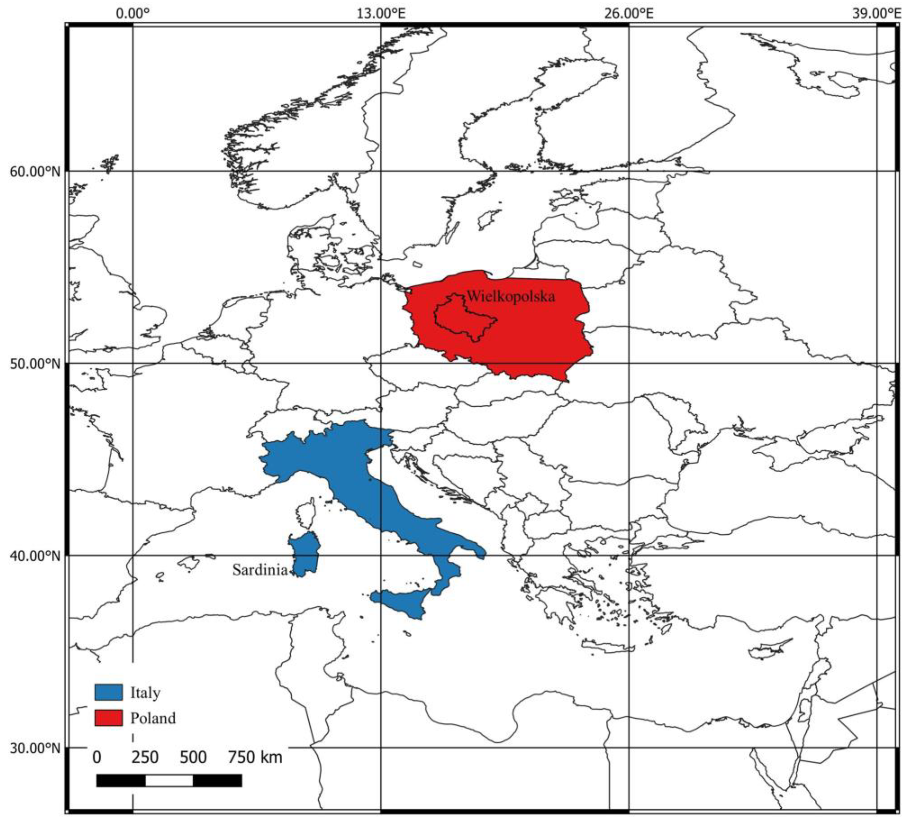
Italy, in southern Europe (
Figure 1), is a democratic republic, which belongs to the European Union. The state extends over a surface area of 302,073 square kilometers and is characterized by a predominantly hilly area (41.6% of the total area), while mountain and plains cover about 175,202 square kilometers (respectively, 35% and 23.2% of the total area; Italian National Institute of Statistics, 2014 [
19]). The Italian peninsula consists of 20 administrative regions, which host about 60 million residents (Italian National Institute of Statistics, 2021 [
20]) in 7904 municipalities (Italian National Institute of Statistics, 2022 [
21]). The municipalities are clustered in—and administered by—80 Provinces, 2 Autonomous Provinces, 14 Metropolitan Cities, and 6 Free Municipal Consortia (Italian Republic, 2022 [
22]).
Italy approved laws with the aim of regulating human behavior in a meticulous way (Italian Republic, [
23,
24,
25,
26,
27]). We can recognize a juridical tradition of Italian law, which assumes that a correct behavior must constantly be referred to a written normative source. The tradition of Italian law has determined a planning system largely based on the so-called “command and control” scheme, according to which the regulatory apparatus requires a top–down approach, i.e., the public administrations promote territorial transformations that are conformed to certain characteristics and check that these transformations take place in accordance with the plans [
28].
The Italian urban planning law [
23] could be considered as one of the most innovative when it was enacted “as it introduced multi-level planning and urban development plans extended to entire municipal territories and limited the building activities of municipalities lacking urban development plans” [
29]. The Italian urban planning law of 1942 was never repealed or replaced and is still in force. In the 1970s, the legislative activities concerning urban planning were delegated to the 20 administrative regions and were characterized by weak strategic regulation and strong heterogeneity [
29,
30,
31], “thus easing forms of control and increasingly delegating decision-making to [also very small and demographically irrelevant] municipalities” [
30].
While the urban planning law of 1942 [
23] focused on the urban development, in the last decades in Italy, the processes of urban growth have undergone a drastic setback, and it has been understood that beyond certain limits the urban sprawl has negative effects for the economy and for the real estate market [
32].
The plans can be classified by the function they perform or by their scale (national, regional, sub-regional, municipal scale).
Table 1 summarizes the main spatial planning activities of Regions, Provinces, Metropolitan Cities, and municipalities according to Petroncelli [
32].
According to De Montis [
28], the coordination plans (e.g., the provincial spatial coordination plans) refer to large portions of the territory (at least inter-municipal scale) and define a framework for the territorial transformations; the operational plans (e.g., the municipal master plans) are approved in accordance with the coordination plans usually at the municipal level and affect the local administrative area; the executive plans concern the implementation of measures—included in the operational plans—in practice.
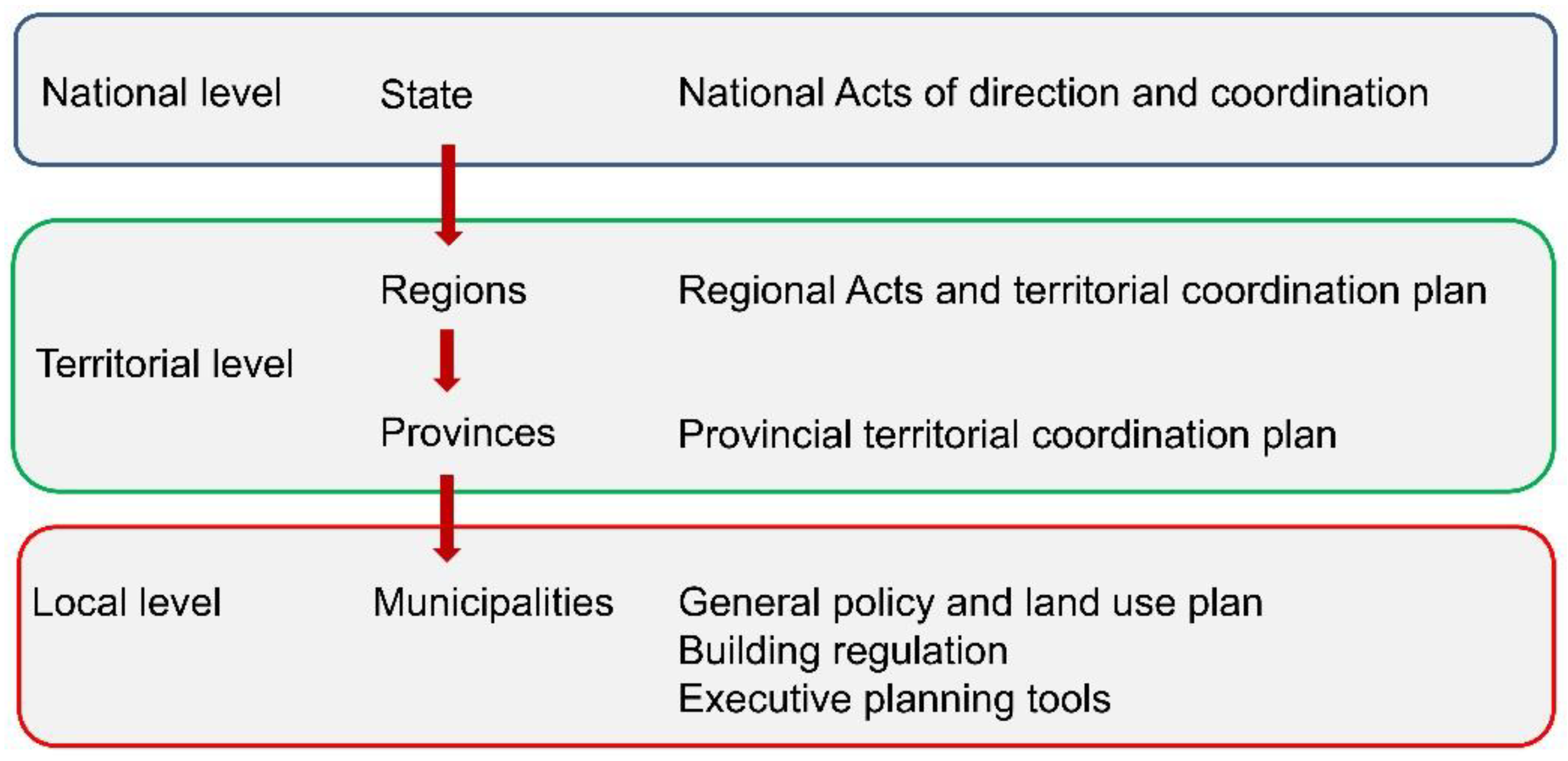
Italy acknowledges four administrative levels: state, region, province, and municipality (
Figure 2, after [
33]; Larsson [
34]). National sector plans adopted at the state level are very rare, as the “planning competences have been transferred to the lower-level administrative bodies” [
4]. Regions, provinces, and municipalities adopt a plurality of instruments—coordination, operational regulation, and implementation instruments—to regulate their own development. Usually, regional and provincial governments draw up instruments (e.g., coordinator territorial plans) aimed at regulating the development of large areas through general provisions, while municipalities regulate changes to their land through municipal master plans [
35,
36,
37,
38].
Poland, officially Republic of Poland, is a country in central Europe (
Figure 1) and since 2004 is a member state of the EU. Poland covers an area of 312,696 km
2 and is the fifth-most populous member state with a population of over 38 million. The implementation of the spatial policy in Poland obeys the Spatial Planning and Development Act (SPDA) approved in 2003. The SPDA regulates the spatial planning system in Poland, including the development of spatial policies and spatial plans (concepts, plans, studies) and attributed different powers to the administrative tiers of government [
39]. The Polish spatial planning and management system has changed a lot over the last 30 years. The most relevant transition occurred after the fall of socialism [
40]. During the socialist era, planning and decision making were centralized so that local authorities had no influence and were mere executors of spatial transformations in their own area. Between 1989 and 2003, the Polish Government established and implemented a roadmap for building a new spatial planning and management system. Similarly, other central and eastern European countries restructured their spatial planning and management system. For most countries, this restructuration has been steered and eased by the process of adhesion to the European Union [
41,
42,
43].
According to the Polish Constitution, the territorial system of the Republic of Poland ensures the decentralization of public power [
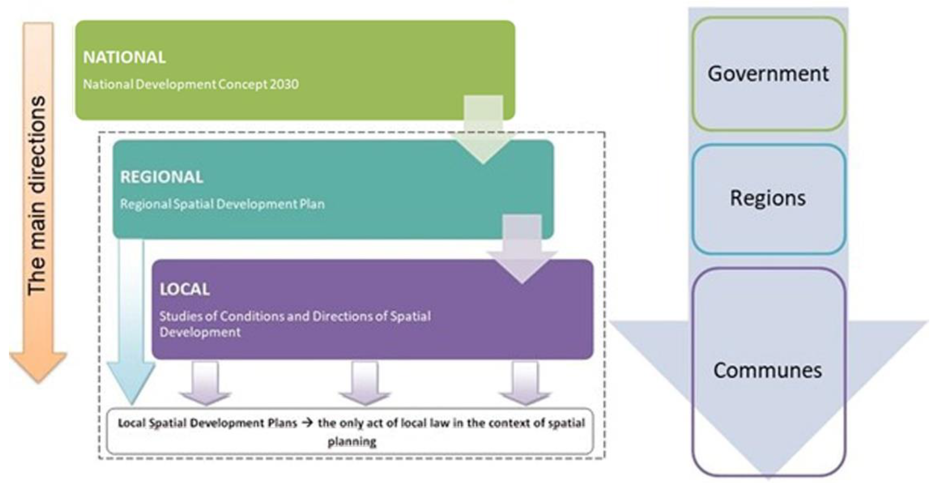
39]. Governmental bodies operate in four hierarchical tiers (
Figure 3): the state, at the national level; sixteen regions (Voivodeship), at the regional level; 379 provinces (Powiat), at the intermediate level; and 2477 municipalities (Gmina), at the local level. National, regional, and local level administrations are committed to land use planning. The national government steers spatial planning, according to the Long-term National Development Concept (Poland 2030), which has integrated and substituted the National Spatial Development Concept. These documents set out the conceptual framework and address the development of the whole country, by organizing the environmental and landscape protection system. Voivodeships play a limited role in spatial planning through the Regional Spatial Plans together with spatial development plans for urban functional areas. Powiats have only minor functions related to planning. The main actors in land-use planning are the municipalities, which elaborate mandatory studies on local planning scenarios for the whole communal area and the Local Spatial Development Plan for part of the community, the only legally binding zoning plan. The disadvantage of local plans is that they are recommended but not mandatory. According to a hierarchical scheme set out by the SPDA, the local plan is drafted in conformance with the spatial development plan of a voivodeship, which obeys to the National Spatial Development Concept and Long-term National Development Strategy (
Figure 3).
4. Materials and Method
In this section, we describe the methodological approach. Firstly, we provide the reader with the list of regional plans considered in this study. Secondly, we introduce the criteria adopted to scrutinize the plans in terms of inclusion of adaptation to climate change and GI concepts.
4.1. Planning Tools Selection
We scrutinized the regional planning tools (including the strategic environmental assessment—SEA—report when available) described in
Table 2.
As for Sardinia, the Regional Hydrogeological Plan (RHP) has been adopted in 2006 by the Autonomous Region of Sardinia. The plan provides guidelines, sectoral actions, technical standards, and general prescriptions for the prevention of hydrogeological hazards and risks in the regional river basin and hydrogeological hazard areas. RHP regulates areas of very high, high, medium, and moderate hydraulic and landslide hazard. The Regional Landscape Plan (RLP) aims to protect the landscape, with the dual purpose of preserving its quality elements and promoting its improvement through restoration and restructuring, even deep restoration when it appears degraded and compromised. RLP relies on three pillars, meaning ‘environmental’, ‘historical and cultural’ and ‘settlement’ settings, and it affects the regional territory, particularly twenty-seven coastal landscape units (LU). An LU consists of regional areas with similar environmental, historical and cultural, and settlement characteristics. The municipal master plans adopted in Sardinia must be consistent with RHP and RLP.
As for Wielkopolska, the Spatial Development Plan (SDP) has been adopted in 2019 by the Wielkopolska Regional Parliament. This is the most important strategic document for the Wielkopolska Region, which defines the spatial policy within the administrative border of the region. The plan defines the model of spatial development, the objectives of spatial policy and directions of spatial development of the region as well as the distribution of public purpose investments of supra-local importance. This document also contains a detailed analysis of development directions for the functional area of the voivodeship capital. The Environmental Protection Program (EPP) for the Wielkopolska Region until 2030 has been adopted in 2020 by the Wielkopolska Regional Parliament and implements an ecological policy for the region with the assumptions of the most important national and EU strategic documents. Conclusions and recommendations formulated in both documents should be reflected in planning documents at the regional and local level.
4.2. Adaptation to Climate Change: Assessment Criteria
We applied the criteria proposed by Ledda et al. [
4]. Ledda et al. [
4] focused on the regional plans adopted by the Autonomous Region of Sardinia (Italy), south European Mediterranean region, which is an area that will be negatively affected by climate change in the coming decades. Ledda et al. [
4] aimed at proposing and applied a method rooted in the scientific literature and adaptation strategies with the purpose of scrutinizing a set of regional plans related to spatial planning issues. The authors performed a document analysis according to the following steps: (i) collection of the main strategic regional plans; (ii) scrutiny of the plans by using specific criteria (
Table 3), to assess if, and to what extent, adaptation to climate change concepts were considered by the plans.
The criteria were used to scrutinize if the plans: referred to adaptation strategies (regional, national, European, or international climate change adaptation strategies); included explicit (measures specifically defined in response to climate change) or implicit (that have not been defined as a response to climate change but are useful for adaptation) measures; identified the responsible bodies for implementing explicit adaptation measures.
4.3. Green Infrastructure and Spatial Planning: Assessment Criteria
De Montis et al. [
18] focused on the integration of Green Infrastructure (GI) concepts in regional plans and programs and proposed and applied a complex index to do so. The study aimed at clarifying if—and to what extent—GI concepts were included in regional plans and programs adopted in Sardinia (Italy). De Montis et al. [
18] defined and applied a quali–quantitative multicriteria method for selecting and scrutinizing regional plans and programs. This method was based on content analysis, inspired by similar criteria-based frameworks, and designed to enable a comparative assessment of Sardinian planning tools with respect to other countries and regions. The method included the use of a composite indicator—i.e., the Complex Index of Green Infrastructure Integration (CIGI)—for ascertaining the intensity of the consideration of GI themes and criticalities in plans and programs. While the methodologic details on the design of CIGI can be retrieved in De Montis et al. [
18], here, we focus on the main elements: simple criteria (
Table 4), scoring rule (
Table 5), and criteria aggregation pattern (Equations (1)–(3)).
The full expression of the composite indicator CIGI reads as follows (De Montis et al., [
18]):
where
and
(with
) are the weights of the domain indicators Complex Index of GI Explicit Integration (CIGEI) and Complex Index of GI Implicit Integration (CIGII), which are calculated according to the following equations:
where
and
are the weights of—respectively—the simple explicit (
) and implicit (
) criteria, with
and
. Weight of
; weight of
.
6. Conclusions
Spatial planning has a key role in the promotion of adaptation to climate change (ACC) and green infrastructure (GI) concepts and principles as well as adequate planned measures. In this paper, we answered to two research questions (RQs). RQ1 aimed at investigating if—and to what extent—key concepts of ACC and GI characterized the regional planning process of Sardinia (Italy) and Wielkopolska (Poland) and pointing out the main strengths and weaknesses of the tools. RQ2 had the purpose of stressing if and how the current organization of the spatial planning system of both Italy and Poland has potential to ease the integration of ACC and ecosystem services—delivered by GI—into practice.
As for RQ1, we found out that the major regional spatial planning tools of both regions are deficient in terms of consideration of ACC and GI issues. The plans mainly met implicit performance criteria. Thus, future updates of the plans must integrate ACC and GI concepts according to European, national, and regional strategies (ACC) or provincial guidance (GIs).
As for RQ2, the multi-level and multi-actor planning system of Italy and Poland can contribute at the integration of adaptation to climate change and GI concepts at the regional and sub-regional scale. Italy has adopted a national adaptation strategy in 2015 [
6]. Thus, Sardinia benefits from a national (and from 2019, regional) framework that promotes adaptation to climate change, i.e., the national [
6] and regional adaptation strategy [
8]. In this regard, the planning system of both states has a central role for the promotion of adaptation from a higher (state) level to lower (sub-regional) level. Neither Italy nor Poland have adopted a national GI yet, but some Italian public administrations adopted guidelines for the design and implementation of GI at the provincial level.
We might speculate that the regional plans show a weak attitude to integrating ACC and GI concepts because of the slowness of the regions to fully integrate such concepts into the regional legislative framework (see Wielkopolska) and to update the plans (see Sardinia). On the one hand, a satisfactory integration of the EU strategies on ACC and GI into regional regulations and guidance documents of Wielkopolska might be relevant to the mainstreaming of ACC, resilience and GI in plans related to SP issues. SP could promote the consideration of such concepts into planning processes, e.g., in the context of strategic environmental assessment. On the other hand, Sardinia needs to update the regional plans, according to the regional strategy for ACC and better include GI concepts into the SP processes. In Poland, there is a clear need to develop or update planning documents and adaptation strategies for regions and subregions, which undergo energy transformation processes relating to moving away from coal. These are strongly transformed areas, in which the processes of mitigation and ACC play a special role. In the case of the Wielkopolska region, this applies to the Konińskie Basin of Brown Coal.
We feel that this research can contribute to the scientific panorama as: (i) it provides the scholars with a methodological approach replicable in similar European geographical contexts; (ii) the study might be of inspiration for planners to assess the quality of regional plans and stress their strengths and weaknesses; (iii) the performance criteria proposed in this study have potential to be utilized as a checklist, i.e., a sort of list of criteria that need to be met in the context of planning processes; (iv) it emphasizes the role of adaptation to climate change and GI concepts in regional spatial planning and provides the regional administrations with reasons that support the need to increase the climate resilience of territories and population to preserve human (and non-human) life. European regions can be inspired by this study to promote the use of GIs for increasing territorial resilience.
The main limitations of this research regard: (i) the small set of regional plans scrutinized and (ii) the basic performance criteria adopted. We aim at increasing the sample of plans and considering additional performance criteria in future research. A further limitation concerns the need to investigate how regional plans are implemented in practice. Future research should investigate what barriers—regulatory or otherwise—hinder the implementation of the scrutinized plans in regard to ACC and promoting the use of GI.


 ,
, 


