Article

Digital Documentation and Conservation of Architectural Heritage Information: An Application in Modern Chinese Architecture

1
Key Laboratory of Urban and Architecture Heritage Conservation, School of Architecture, Southeast University, Nanjing 210096, China
2
School of Design and Applied Arts, Albertina Academy of Fine Arts, 10152 Turin, Italy
3
Department of Architecture and Design, COMSATS University Islamabad, Islamabad 45550, Pakistan
*
Author to whom correspondence should be addressed.
Sustainability 2023, 15(9), 7276; https://doi.org/10.3390/su15097276
Submission received: 20 March 2023 / Revised: 24 April 2023 / Accepted: 25 April 2023 / Published: 27 April 2023
(This article belongs to the Special Issue Sustainable Conservation of Urban and Cultural Heritage)

Abstract

:
With the rapid advancement of technology, accurate and reliable architectural heritage information is increasingly in demand in the fields of cultural heritage and architectural conservation. This study aimed to establish a positive and harmonious relationship between architectural heritage and urban renewal in China’s sustainable urbanization process by documenting and conserving Chinese architectural heritage information. This work focuses on integrating architectural heritage information into multilevel and multi-dimensional information using scientific and standardized classification methods for documenting and conserving Chinese architectural heritage. The former site of the provisional Senate of the Nanjing National Government was studied and documented for this purpose. A precise 3D modeling for the components of architectural heritage and building information modeling (BIM) technology based on the two-dimensional (2D) drawings and component information were studied, analyzed, and used for restoration. Finally, a component “family” library was created using the common components of existing historical buildings. The results showed that the proposed method could provide both 3D and 2D drawings directly in the digital protection of historical buildings to monitor, repair, and protect architectural heritage, particularly historical buildings, throughout their life cycle. Overall, this work highlights the importance of protecting architectural heritage in sustainable urbanization and proposes an effective method for achieving this goal.

1. Introduction

1.1. Modern Chinese Architectural Heritage in the Context of Sustainable Urban Renewal

After 1840, Chinese society and culture underwent a period of transition and transformation, which profoundly impacted the development of modern Chinese architecture. During this period, traditional Chinese architecture coexisted with the spread of Western architectural influence. The collision and blending of various architectural styles and the introduction of new materials, techniques, and construction methods have created a special class of modern Chinese architectural heritage, a new product of multiculturalism [1]. From both material and spiritual perspectives, modern Chinese architectural heritage occupies an important position and has significant value for research, preservation, and reuse. It has gradually become one of the most important cultural phenomena reflecting social changes and playing an essential role in uplifting people’s spirits and promoting national culture during challenging times [2]. Therefore, the sustainable protection and utilization of modern Chinese architectural heritage are crucial for preserving the cultural identity and heritage of the nation, promoting social harmony, and contributing to sustainable urban development.
However, development and protection entail both contradictions and challenges. Despite the constant improvement in China’s urbanization, the environmental quality of many historical buildings has not kept pace with progress. Neglected development in old districts, outdated infrastructure, and a lack of cultural self-confidence among residents have become prominent issues [3,4]. Furthermore, some once-thriving areas have fallen into disrepair and can no longer meet the needs of contemporary life. Historical and cultural heritage is a unique source of wealth and resources for a city, with past and present values. Therefore, merely repairing and renovating buildings on a material level is inadequate to address these issues in a sustainable manner. Sustainable urban renewal must be a comprehensive process encompassing historical, social, economic, and cultural changes. Preserving historical and cultural heritage is an essential aspect of building a sustainable city. The unique architectural heritage of the city is a valuable asset for the vital preservation of its cultural and historical legacy. Community participation and empowerment are also important ways to support sustainable development goals, promote sustainable and healthy urban development, and encourage the participation of all sectors of society.

1.2. The Application of Digital Technologies

The principles of sustainable development place higher requirements on the actual operations of urban renewal. Their requirements include establishing an information platform open to the public and taking advantage of all parties’ strengths to carry out salvage recording, investigating, and collating data on modern architectural heritage nationwide [5]. A city’s architectural heritage is an essential carrier of the Chinese traditional culture, preserving its artistic and scientific values and also its spiritual pillar [6]. It is important for the transition to urban culture and should take part in guiding urban renewal. It is, therefore, necessary to avoid damage to buildings and cultural heritage sites and to eliminate the negative impact on the original historical environment.
The Central Office’s “Several Opinions on Strengthening the Reform of the Protection and Utilization of Cultural Relics” proposes to make full use of the Internet, big data, cloud computing, and other technological means to increase scientific and technological support. Information technology and artificial intelligence promote the integration and innovation of cultural heritage display and utilization. With the continuous advancement in heritage protection, the preservation of heritage is relatively good. However, according to modern criteria, there is a need to move away from traditional heritage protection practices towards a more scientific, systematic, and comprehensive approach to heritage information management. The promotion of in-depth investigation, analysis, and comprehensive display of heritage value, as well as dynamic monitoring and early warning, can drive the transformation from passive rescue protection to active, systematic, and preventive heritage preservation and management [7]. This engenders heightened demands on the operational mechanisms of heritage conservation.
In 1975, Chuck Eastman, the “father of BIM” at Georgia Institute of Technology, first proposed the concept of building information modeling (BIM) [8]. In 2002, Autodesk implemented it on a technical level. BIM is based on three-dimensional digital technology and integrates various related information on architectural engineering projects into an engineering data model [9]. This technology establishes the concept of “family” based on building components’ construction position and geometric shape. Each “family” type corresponds to a building component or part, and the building model is constructed by calling the family components into the project. Building components come with attribute tables, allowing users to insert attributes such as materials, construction levels, sizes, and numbers. This model is the object of collaborative work among various professions and can achieve full life-cycle management of architectural design, construction, and operation.
BIM directly manages building information and uses the basic geometric units as the building components. An information management system indexed by a three-dimensional model can be established by embedding or linking various nongeometric information to the corresponding component attributes. It can effectively utilize analytical functions such as data comparison, detail table queries, and component extraction. Therefore, from the perspective of information management, a geographic information system (GIS) manages the macro information of the building, while BIM is the appropriate means of managing the micro and meso-level building data. Combining the two systems can establish a technical platform for the full life-cycle management of architectural heritage [10].
The cultural heritage of the historical buildings may be compromised by poor maintenance, earthquakes, fire, and other forms of natural and anthropogenic destruction. To preserve and protect this heritage, the information about it must be saved in a digital format. Damaged historic buildings require protection and restoration based on information stored in computers. The virtual digital restoration of cultural relics is realized by modeling the “family” components library of the existing historical building and recalling the required components in the BIM process. Using BIM technology, each damaged historical building can be digitally cut and saved in the project to control the construction progress and improve the efficiency of its maintenance work.
China’s architectural heritage has a unique style with rich historical, cultural, and artistic values. However, its protection fails to fully consider the architectural characteristics of China’s large wooden structures. Thus, the management of operations and maintenance of architectural heritage needs to improve and take full advantage of the continuous development of information technology and scientific preservation and management methods. This study analyzes the feasibility and necessity of applying BIM technology to the maintenance of architectural heritage information, proposes to create a BIM-based architectural heritage information management platform, and studies its implementation.
The innovation points of this work can be divided into the following two points:
(1)
For the information acquisition, a new method based on the software environment of Autodesk Revit is proposed, drawing on the classification method of archeological typology, which provides a new concept and a new model for the development of surveying and mapping of cultural and architectural heritage;
(2)
For the construction of the information platform, the models for different levels of information are further refined to lay a solid foundation for supporting the investigation, preservation, monitoring, and management of cultural heritage and ensure the security, authenticity, integrity, and continuity of the heritage information.
The aim of this research study is to take the construction of the architectural heritage model as the starting point and summarize the experience in the construction process. The work puts forward targeted countermeasures for model construction and information storage. The significance of this study lies in providing practical reference and operational support to the digital information management of architectural heritage.

2. Literature Review

Significant research has been carried out related to issues of architectural heritage. Fadli and AlSaeed (2019) [11] investigated Qatar’s existing architectural heritage, urban conservation methods, principles of modern digitization, and archiving technologies to create a sustainable, interactive archiving platform, namely, the Historic Building Information Modeling (HBIM) platform in Qatar. This unique digital platform is designed to respond to urban heritage conservation and building restoration needs. Moyano et al., (2021) [12] pointed out that 3D point cloud data acquired through ground photogrammetry, close-range photogrammetry, light detection, ranging, etc., play a vital role in heritage preservation. Point clouds can be exported to BIM, simplifying the 3D modeling process as part of a restoration and reconstruction project. Most scientific research in this field currently employs procedures for inserting point clouds into BIM. Some studies have analysed the literature on the scientific literature on integrating terrestrial laser scans and structures from motion/multi-view stereo data into HBIM. Bianco (2018) [13] designed and implemented a multilevel, interactive topographic map of Tuscia’s cultural heritage. The study found that geographic information system (GIS) maps could match some of the surveying and mapping options in the cultural heritage sector and define two-tier database records according to the Midas standard. Masciotta et al., (2021) [14] explored the leading role of digitization in historical and cultural heritage conservation projects. The program developed a comprehensive digital-based approach as a tool for properly and more accurately recording the information on cultural heritage buildings and allowing cultural relic owners to directly participate in the process. Soler-Estrela (2018) [15] used 3D laser scanning to collect first-hand on-site data based on the surveying and mapping of the relocation project of a historical building. Höll et al., (2014) [16] investigated a high-accuracy 3D scanning device designed for ancient rock art sites in the European 3D-Pitoti project. This device captured the 3D structure and radiometric surface properties with high accuracy and precision beyond photo texture. The article highlighted the importance of achieving excellent registration of scanned 3D data for a seamless transition between scales. The novel micro-range scanner used in the 3D-Pitoti project avoids common structure-from-motion drift issues and can be used for other architectural heritage sites. Overall, this study demonstrates the potential of advanced technology in preserving and documenting architectural heritage for future generations. C. Alexander et al., (2015) [17] put forth an integrated multi-scalar approach for 3D recording of rock-art sites, with a specific emphasis on micro- and mid-scale elements in their landscape contexts. Their research primarily focused on the recording of 3D models. V. Mascardi et al., (2014) [18] introduced a holonic multi-agent system designed to interpret rock art sketches, images, and texts. The system tackled the challenges of rock art interpretation by adopting a distributed approach that synergized the strengths of both human experts and computational agents. The system leveraged multiple agents’ knowledge and expertise to provide a comprehensive interpretation of rock art, addressing the challenges of interpreting different types of cultural heritage site information. D. Briola et al., (2017) [19] introduced a technique that combines nonlinear deformation models and unsupervised clustering to achieve petroglyph recognition in the IndianaMas project. This technique provided novel insights and effectively automated the identification and classification of petroglyphs for better protection and preservation of cultural heritage sites.
The data processing software is used for splicing, denoising, and streamlining into BIM software for 3D modeling, and point cloud slices are used to draw the 2D plan, elevation, and profile to meet the needs of relocation and reconstruction of historical buildings. Combining 3D laser scanning technology with BIM technology offers a valuable contribution to the protection, maintenance, demolition, and construction of historical buildings. However, until now, the use of BIM technology in architectural heritage conservation, both domestically and internationally, has not been a high priority. It has only been used in a small number of cases concerning antique buildings in China and only to construct virtual models, not for the 3D architectural information indexing requirements. BIM technology has not yet formed an exclusive platform for architectural heritage. To achieve that goal, more BIM research is needed.

3. Materials and Methods

3.1. The Standardized Digital Classification System of Architectural Heritage Information

The characteristics of architectural culture are diverse, and in studying the protection and preservation of traditional culture, more knowledge will continue to emerge. The preservation of architectural heritage using digital technology must be classified in a way that allows information models and systems better compatibility and expansion [20]. Traditional heritage architectural materials do not follow a clear classification criterion, and many may be intertwined and interrelated. Adopting a digital approach overcomes the inherent complexity of this information and allows us to understand and analyze it from a more comprehensive digital perspective in which the information is incorporated into a clearly structured framework [21]. Considering that the research scope of this work is limited to the aspect of detailed planning, the technical process of compiling architectural heritage protection planning follows four stages:
(1)
A collection of architectural heritage information;
(2)
Analysis and evaluation;
(3)
A compilation of conservation planning;
(4)
Implementation of planning and monitoring by referring to the relevant provisions of detailed urban planning.
Figure 1 shows a technical flow chart model of architectural heritage conservation planning.
On the basis of the extensive research and experimental application of digital technology in the conservation of architectural heritage by our laboratory, below, we summarized the methods of digital modeling and preservation of architectural heritage divided into three steps.

3.1.1. Information Gathering

Figure 1 shows that information gathering is the most preliminary stage in the preparation of heritage records and conservation plans. The collection of information involves first, the investigation of the current resources on the architectural heritage building/site and its surrounding environment, and second, the collection of the material on the current state as well as the historical, social, cultural, economic, and natural environment of its surrounding area.

3.1.2. Investigation

In the Guidelines for the Protection of Cultural Relics and Historic Sites in China, the activities in the information collection stage are summarized as general survey, review, and key investigation. In addition, some activities are classified as general investigation or special investigation.

3.1.3. The Analysis and Evaluation Stages

The analysis and evaluation stages are based on the current investigation and data collected in the earlier information collection stages. This stage involves value, preservation state, management conditions, threat factors, research status, and display of the architectural heritage. More specifically, the concrete analysis and evaluation are conducted with the view of the ontological value of architectural heritage, defined by, e.g., the state of preservation of architectural heritage building/site and its surroundings, the status of existing protection and management measures, factors threatening its safety, knowledge of and relevant research, displayable content, and social benefits of architectural heritage building/site and its surrounding environment.
The basic materials of architectural heritage primarily include existing physical materials, literature materials, folklore, etc. Physical materials provide objective and factually verifiable information, while literature and materials related to documentary records from different historical stages are a source of relatively subjective material. Physical materials reflect their technical and artistic value, while literature reflects their social background and historical characteristics [22]. On the basis of big data thinking and a large amount of collected information, the authors have constructed and proposed a standardized data analysis method for China’s modern architectural heritage digital library. It analyzes the basic information on China’s modern architectural heritage at the macro, meso, and micro levels.
The standardization of information facilitated resource provision in the following areas:
(1)
At the macro level, the standardization of information on China’s modern architectural heritage encompasses a comprehensive analysis of the city and its context, a record of basic information on modern architecture, and an introduction to the buildings’ structural systems that were prevalent during a specific era, including but not limited to reinforced-concrete structures, brick and wood structures, and steel and wood structures.
(2)
The meso level analysis encompasses various aspects of modern architecture, such as the biographies of key architects, building materials, structure systems, detailed practices, interior and exterior construction techniques, historical context, decorative features, and architectural styles, including Western classical architectural forms, traditional Chinese forms, new ethnic forms, and modern forms.
(3)
At the micro level, the digital library specifies detailed collection and display standards, including naming methods for files, rules for using computer software, standard requirements for archiving, common issues in modeling, principles of architectural photography, and contents of architectural texts. The three-dimensional modeling database of Chinese modern architecture based on Revit software also standardizes the principles of modeling, storage, and use for related projects and complementing and extending surveying work.
In terms of value evaluation, the database assesses the artistic, historical, social, scientific, and practical values of Chinese modern architecture. The evaluation criteria are based on the authenticity and integrity principles of UNESCO’s cultural heritage of architecture and the “Nara grid” [23] established by the Nara Declaration, providing a scientific basis for management decisions.
The significance of establishing these standards is to improve and ensure the quality of digital databases and regulate and guide the collection and recording of information on Chinese modern architectural heritage. At the same time, these standards ensure the achievement of project goals. Table 1 shows the standardized information classification method of the architectural heritage digital library.
Cultural information pertaining to architectural heritage supplements the physical information, breathing life into the architectural heritage and reflecting its historical and social value. The digital architectural heritage should be collected, sorted, analyzed, and preserved as comprehensively as possible. The framework of BIM is presented in Figure 2.
Architectural heritage preservation, as much as contemporary architecture, must go through the process from conceptual design to on-site construction. Digital technology was used to perform a virtual digitizing process of architectural heritage so that the output information of each stage could be classified according to the usual planning steps.
The process of digitizing the physical information of architectural heritage can be regarded as a kind of planning carried out according to the following steps:
(1)
Research related to climate and regional characteristics;
(2)
Comprehensive planning taking into consideration the size and shape of architectural heritage;
(3)
Depiction of the building’s plane and elevation through meticulous drafting and creation of its section and three-dimensional (3D) design using advanced modeling techniques;
(4)
The use of digital design methods for spatial form, structural processing, construction methods, etc., and the selection of materials and colors.
Digital research on traditional architectural craftsmanship is equivalent to the design of engineering drawings. Using this method can help classify architectural heritage design and construction information and better understand the digitization process of architectural heritage [24,25]. Table 2 denotes the information classification system of design and construction.

3.2. Overview of Case Studies in Research

Our research group has collected information on more than 1500 cultural heritage buildings from over 10 representative cities in modern China, which have been recorded and stored in a digital library. The majority of the recorded heritage buildings still exist or have drawings available, and their information was collected using traditional surveying methods. The digital library classified Chinese modern architecture according to the standardized information classification method described earlier; for example, by listing each building, building complex, or historic environment as an entry, with exact dates of construction and completion obtained by accurate research. Then, the entry was assigned the attributes of the city and building type, forming a surjective mapping relationship across multiple resource databases.
It was essential to record information authentically to establish a rigorous standard for the Chinese modern architectural heritage digital library. A standardized database was able to address the poor coupling and correlation of digital information resources, allowing for direct retrieval and use of core information resources. As shown in Figure 3, the left panel (a) depicts the front-end homepage of the digital library, which applies cloud computing technology. Researchers can enter specific information regarding historical buildings on this page to search, match, and retrieve complete 3D models and their corresponding information. The right panels display the digital 3D reconstructed models of significant historical buildings obtained through the case study using the methodology described in this paper. These models provide evidence for the argumentation presented in this study, including (b) the former site of the Nanjing branch of the Bank of Communications, (c) Dahua Theater, (d) the Yangtze Hotel, and (e) the former site of National Government Ministry of Foreign Affairs building.
This paper focused on the former site of the provisional Senate of the National Government as a case study, because of the difficulties in conducting detailed manual surveying caused by ownership issues. To address this challenge, the site was selected as a sample for 3D reconstruction technology, exploring a new approach for recording and preserving historical architectural information.
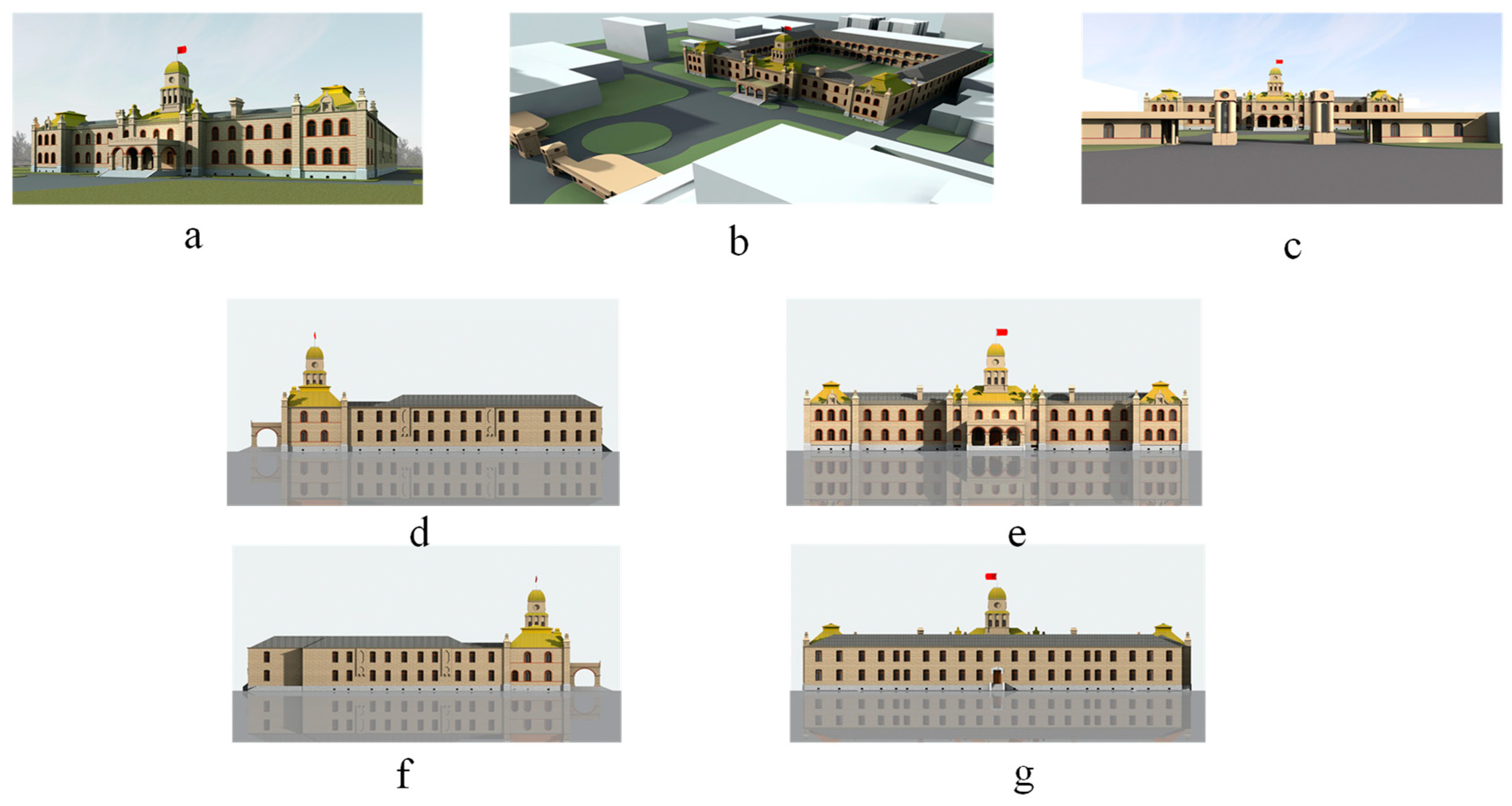
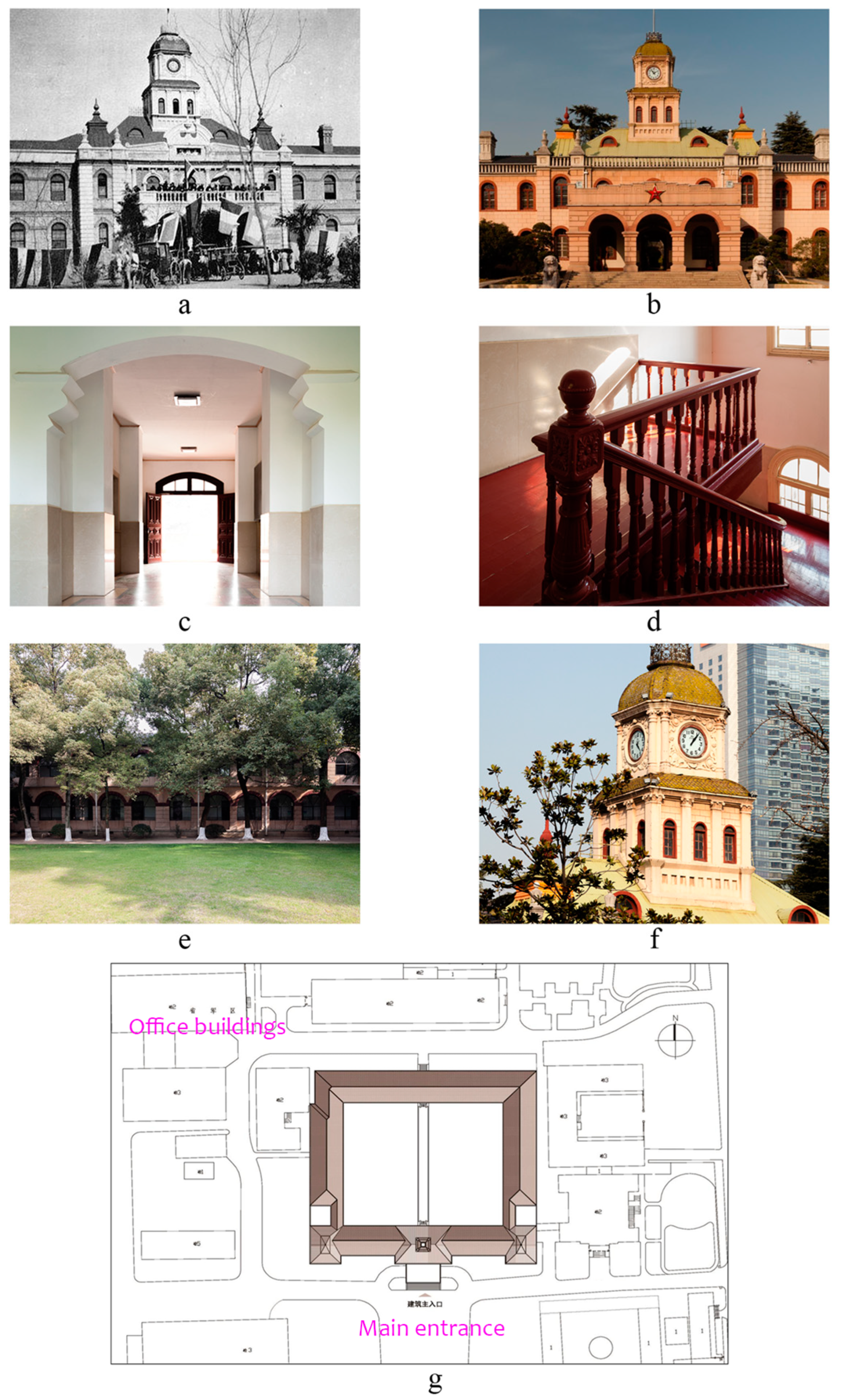
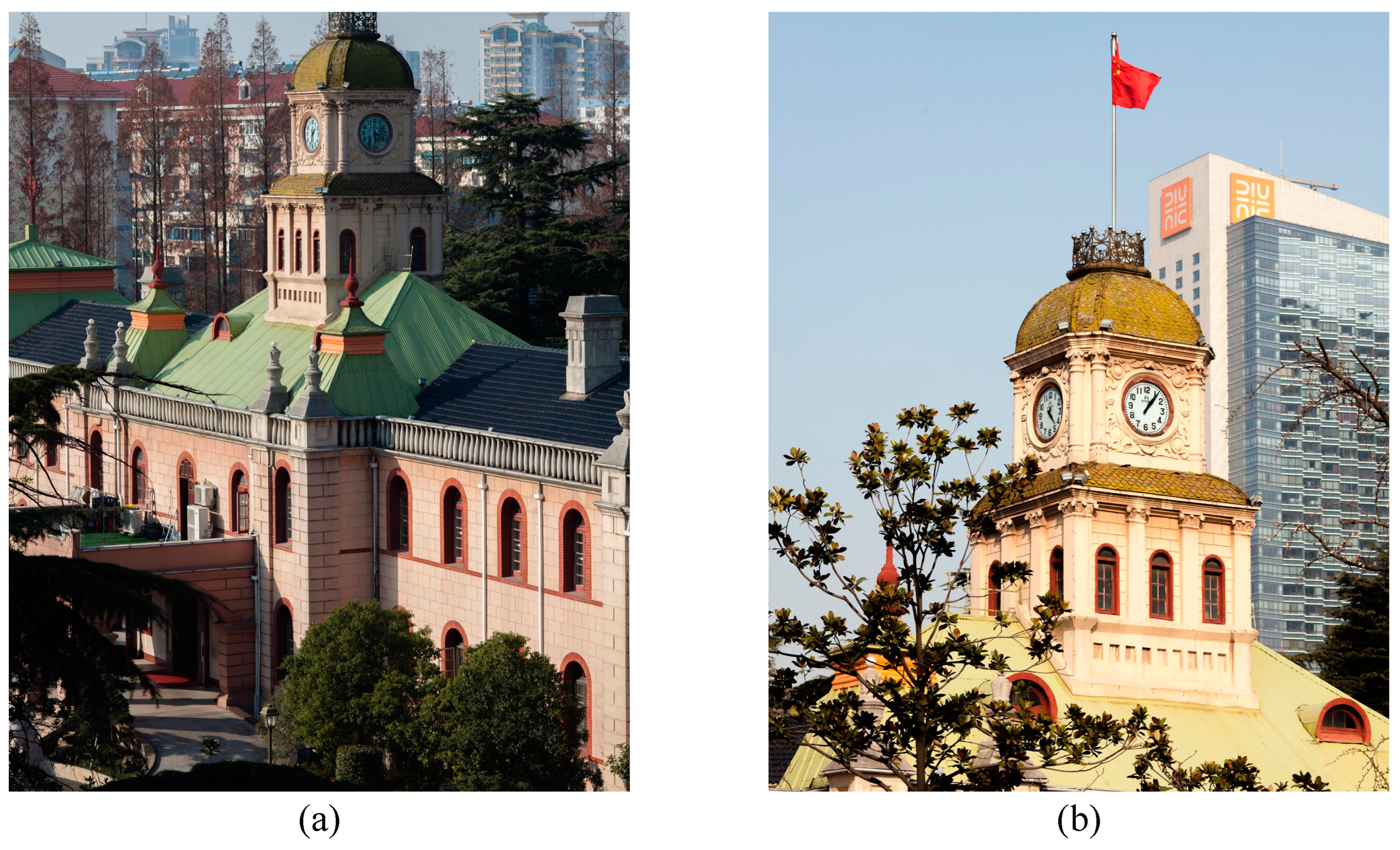
The former site (main building) of the provisional Senate of the National Government began construction in 1909 [26,27] and was completed the following year. The main building combines French classical and Baroque architectural details, which was groundbreaking in its architectural type, design, and construction (as shown in Figure 4). The main building is a brick–wood hybrid structure, the central part of which is approximately square and has two floors (about 11.8 m high). A six-story bell tower (about 22.6 m high) is above the main entrance. The exterior walls of this building were originally made of fair-faced brick masonry with round-arched windows. The foundation and ridges are made of bricks from the Nanjing city wall. The main part of the roof is a two-fold four-slope roof covered with green tin tiles and supported by triangular wooden purlins. The roof also includes small minarets, railings, chimneys, dormers, and other architectural elements. The bell tower has a square-bottomed dome with a metal scale tile roof. The building has distinct three-stage characteristics. Through observation and research, it was found that there were problems with the former site of the provisional Senate. First, the structural system of the main building was chaotic [28,29,30], and the structure layout was not reasonable. The main components, such as the walls, wood, and concrete floors, showed obvious structural damage, which affected the safety and seismic stability of the structure. Second, there was considerable damage to the exterior facade of the building. It was originally architectural with fair-faced brick walls, the top of the doors and windows was a fair-faced red brick arch, and the center of the door was a keystone with fair-faced red bricks. A continuous fair-faced red brick wall decoration belt extended between the arches, and the rest of the fair-faced brick walls were made of gray bricks. Between the first and second floors, there was a stacked-brick skirting. The middle and four-corner columns were decorated with terrazzo and divided by imitating stone. Because of disrepair, over time the exterior wall brick of the building was pulverized. The original architectural features that have disappeared due to damage and the passage of time need to be restored urgently [31]. An overview of this building is shown in Figure 5.

3.3. Construction and Digital Protection of Building Information Management System

The method employed in this research involved studying various historical stages of architectural heritage [32,33,34] and carrying out activities such as recording, mapping, repairing, and monitoring after the protection of architectural heritage has been established. Its process and results were integrated and managed in the information management platform to serve the operation of architectural heritage maintenance management [35]. The core technical framework of the BIM information management system involved GIS, Revit (Autodesk software module), and databases (digital library). The further subdivision involved the creation of BIM, information operation, data management, data interface, coding rules, and other links. As an important node in the information network, the management efficiency of each node affected the work efficiency and automation level of the whole information management platform [36]. The BIM creation process of architectural heritage was divided into three stages: data preparation, creation of a component family, and model construction.
In the context of conserving and restoring Chinese modern architectural heritage, using digital technology to aid in information collation and conservation was of significant practical importance.
There were five important steps in the creation of a component family:
(1)
Component research: the setting position, structural function, and conventional types and shape changes of ancient architectural components were understood, the component was decomposed, and the volume was determined to decide its main geometric parameters;
(2)
Selection of family template: according to the type of component, the appropriate family file template was selected;
(3)
Drawing of geometric information: the layout was helpful in drawing the reference plane of component geometry and adding reference lines and dimensions, where the size attribute parameters were set step-by-step based on the geometric characteristics of the component, and parametric definition was carried out to meet the requirements of model reuse to the greatest extent;
(4)
Inspection of geometric parameters: it was necessary to verify whether the setting of dimensional parameters was successful and whether there were missing items in order to carry out a reuse inspection, returning to geometric information for modification, if necessary;
(5)
Addition of nongeometric parameters: different text attribute parameters were added for family components, including component code, component name, material, and other information.
On the basis of the BIM technology, this work studied the reasonable and effective information management methods in modeling architectural cultural heritage, selecting laser 3D scanning technology to collect the preliminary data and using the Autodesk Revit modeling platform to collate and manage the digital information on architectural heritage. The building components were classified according to the specific functions, and the architectural cultural heritage information was integrated through the model [37]. On account of the classification of architectural typologies, this work divided the building into the roof, column, staircase, envelope, and other component types, and recorded and managed related information with corresponding “family” types [38]. At the same time, the “family” component was used to build the overall model of the provisional Senate of the Nanjing National Government site, thus meeting the demands of information integration at all levels of architectural heritage and the need for information extraction from all parties.
The building of the provisional Senate of the Nanjing National Government is magnificent and exquisite, and accurate data information was required to build the model. The laser point cloud data in this work were collected on 19 October 2022. The 3D laser scanner was used to collect the shape data of the architectural heritage, and a total of 100G capacity data were obtained. The acquisition was carried out in the daytime. First, the surrounding environment of the former site of the provisional Senate was comprehensively evaluated, and the 3D laser scanner site was preset. Then the 3D laser scanner was used to obtain the point cloud data of the former site, and the Cyclone software was employed to perform the site model splicing operation. After the noise removal and registration processing, the imp format file was obtained and exported to the rcp format file. Next, the rcp format file was imported into Autodesk computer-aided design (AutoCAD) software or Revit Architecture for data segmentation and ranging. Moreover, the point cloud data were obtained and used as the source and reference of geometric information required by the former site model. Finally, through the 3D point cloud model cutting, the data information of specific components was measured with basic measuring tools, and the specific location of components was checked during the model-building process. The point cloud data of the building are denoted in Figure 6.
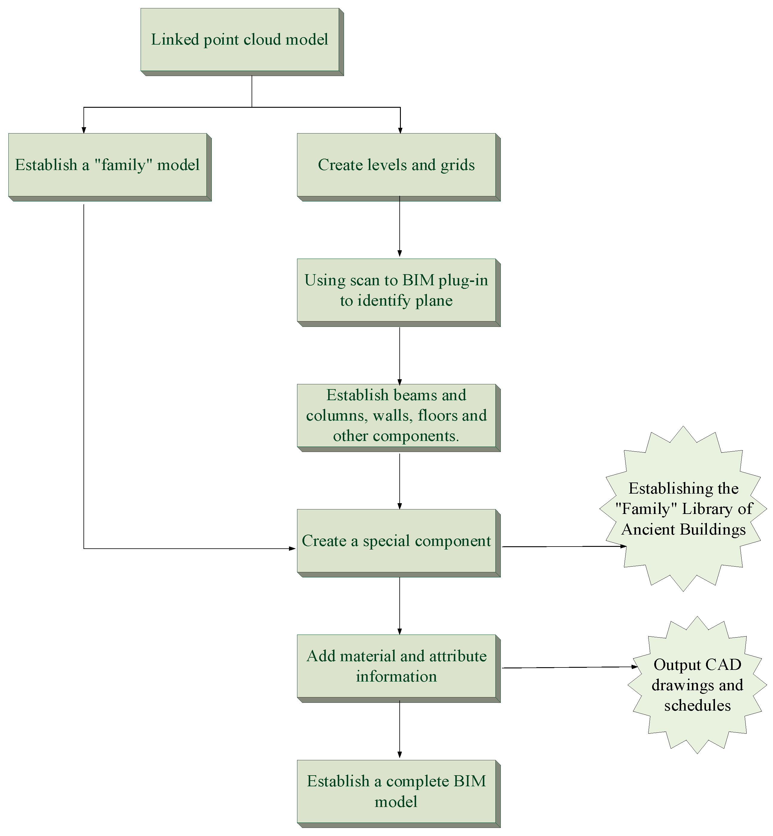
The process of establishing BIM based on point cloud data is shown in Figure 7. It principally included linking point cloud data, building a “family” model, building annotation symbol primitives, building a complete model, and adding attribute information.
The construction of BIM required detailed models and information on components, including the internal structure of the building. The family classification of Revit was able to realize the integration of architectural heritage components. The components were classified according to the architectural construction characteristics, typological analysis, and field survey information collection. The types and quantities of components were counted to accurately evaluate the architectural heritage. After that, specific building information was added to the bell tower model and roof property sheet. In Revit, the building information in text form was added as needed, including the name, material, color, age, and others. The material of the bell tower and the relevant text information were set in the properties of the material and decoration bar, and the newly defined “family” file was saved. To complete the overall building model, it was loaded into the project for the overall building test. Modeling and information recording of decorative bell tower components and roof components were completed according to the above steps.

3.4. Methodology

The discussion above summarizes the methodology adopted in this study, which involved integrating the architectural heritage information into a multilevel and multi-dimensional information framework using a scientific and standardized classification system. This framework facilitated the preliminary collection, investigation, analysis, and evaluation of the information, followed by establishing a digital library based on big data thinking to serve as a database. This database could store and retrieve structured and unstructured architectural information and support the preparation of architectural heritage conservation planning. To monitor, repair, and protect architectural heritage, particularly historical buildings, throughout their life cycle, BIM-based digital technology was employed.

4. Results

4.1. BIM Generates Plan, Elevation, and Section Drawings of Historical Buildings

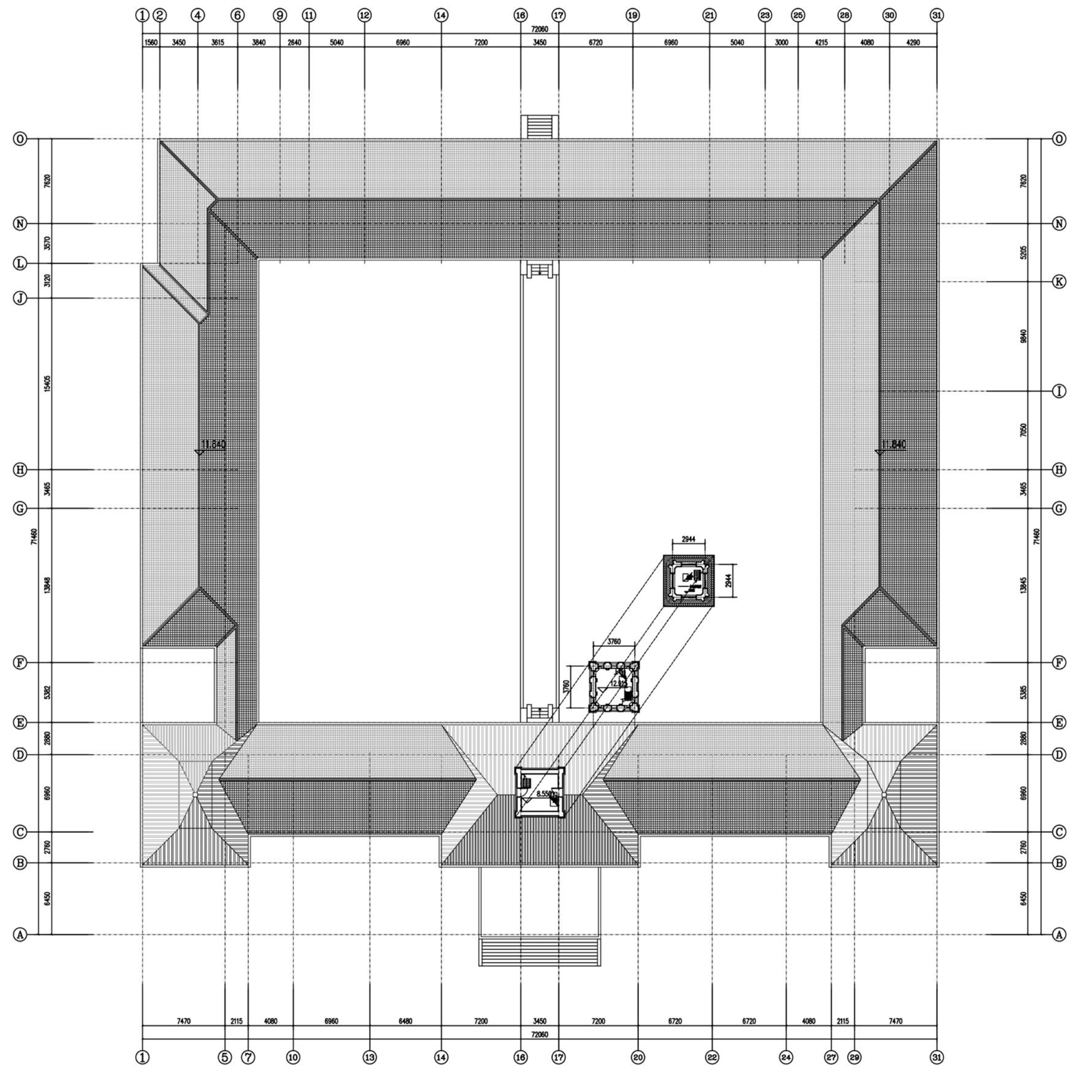
In traditional BIM, both 3D models and 2D plane graphics can be generated. Construction drawings play a pivotal role in engineering design and process. In the existing BIM, the plan and elevation views can be obtained through the section cutting of the BIM. Because of the complex structure of historical buildings, it is often necessary to depict their parts and details on a large scale, resulting in detailed drawings of architectural features. In the plan view of the old building selected as a case study, the appropriate plan view was selected, its stereoscopic view was copied, and information such as annotations, etc., was drawn on the new plan [39,40,41,42]. Figure 8 refers to a partial plan view of the bell tower of the former site of the provisional Senate.
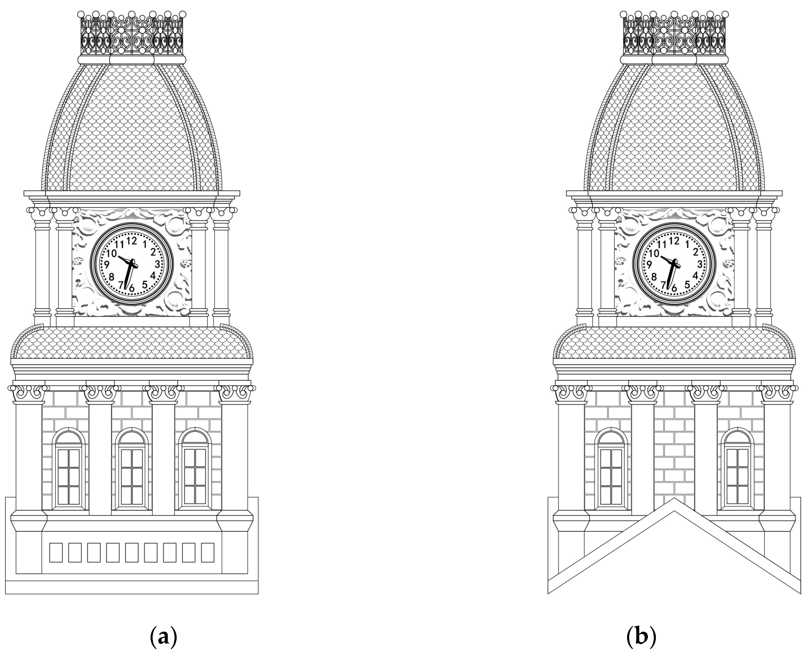
Figure 9 presents the front and side elevations of the bell tower. The elevation of a building indicates the orthographic projection map obtained by the orthographic projection of the outer wall of the building. Similar to its plan, the elevation was also one of the basic patterns of representing the building, reflecting its form and appearance.
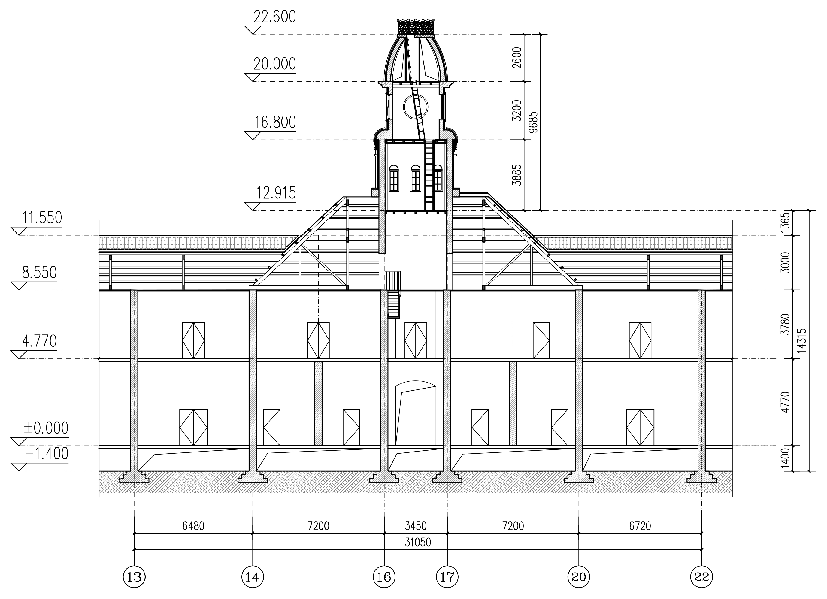
A sectional view of the bell tower is displayed in Figure 10. The sectional view refers to the projection drawing obtained by vertically cutting the building with an imaginary section plane. It mainly reflects the structural form of the building, the utilization of vertical space, and the structural practices of each floor.
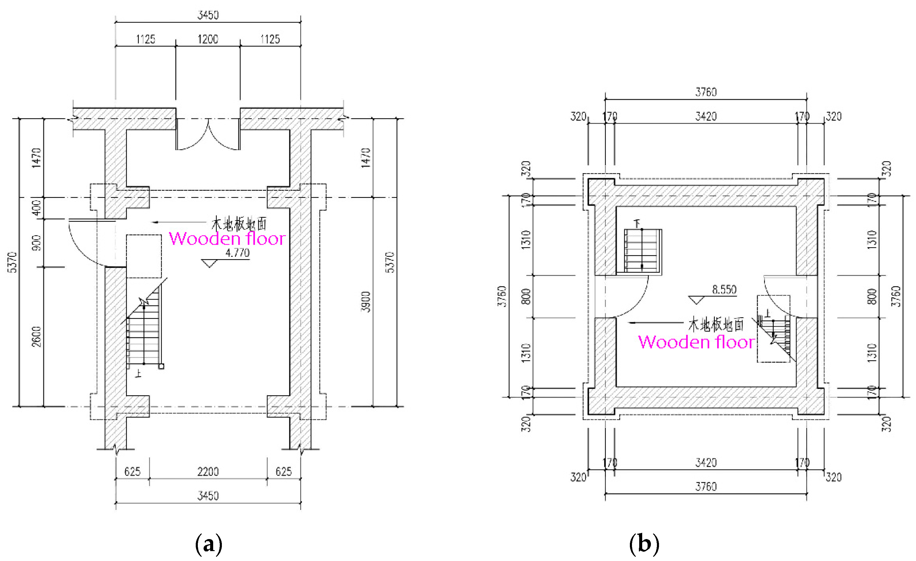
Architectural details are mainly supplements and explanations of local structures and details that cannot be fully expressed in the plan, elevation, and sectional views of the building. Figure 11 indicates the plan for the 2nd and 3rd floors of the bell tower. Figure 12 displays the plan of the 4th and 5th floors of the bell tower, and Figure 13 shows the plan of the 6th floor and the roof of the bell tower.

4.2. Digital Restoration of Modern Architectural Cultural Heritage Based on “Family”

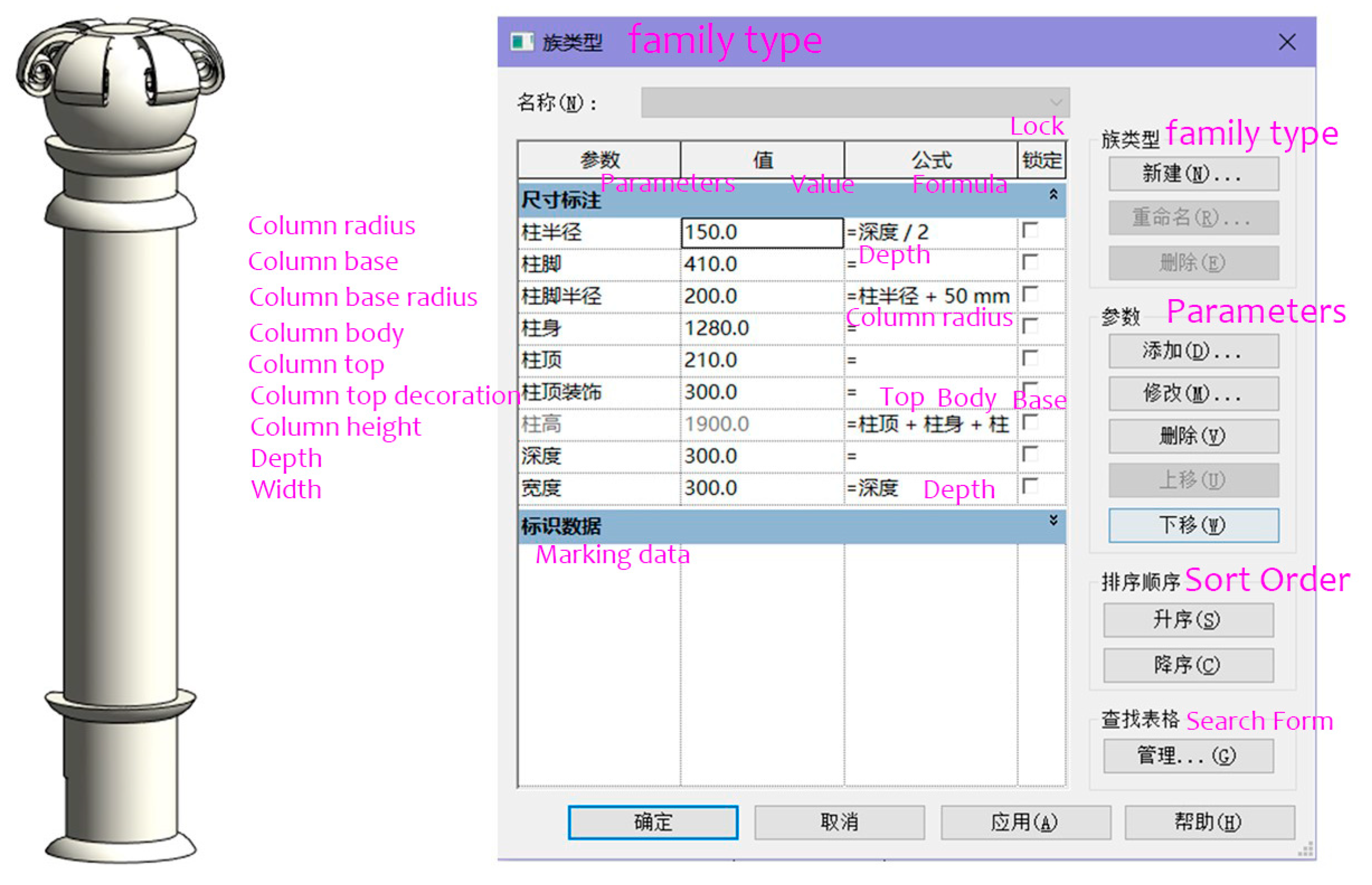
The new modeling technology was able to greatly improve the modeling efficiency of historic buildings. First, the historical building components were classified, then the corresponding “family” components were established, and these components were parameterized. BIM was managed, and model information was saved. The “family” model was essentially a type of building component, a basic unit of BIM. The architectural information of all historical buildings could be obtained in BIM, which greatly improved the efficiency of historical building restoration. The bell tower sub-column (Figure 14) was parameterized with a column radius of 150.0 mm, a base of 410 mm, a base radius of 200 mm, a body of 1280 mm, and a cap of 210 mm.

4.3. Digital Restoration of the Cultural Heritage of Historical Buildings

Figure 15 shows the building of the former site of the provisional Senate.
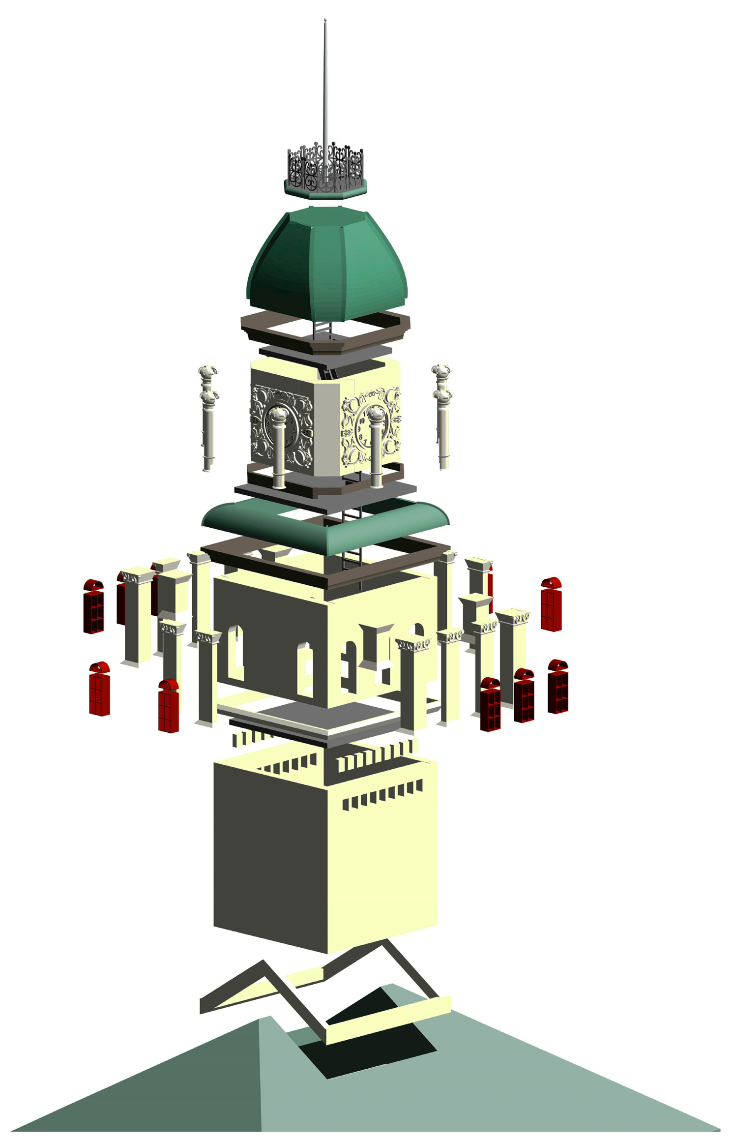
On the basis of the site pictures and the survey, the building’s overall structure remains relatively intact, although the exterior outline has suffered partial damage. To address this, the “family” component discussed in the previous section was used to digitally repair the building. This process involved data collection and on-site reconnaissance to obtain complete information about the building and create an architectural BIM model for historical buildings, saving its components as “families”. This approach ultimately led to the formation of a component library. Figure 16 depicts a dismantled view of the building’s bell tower.
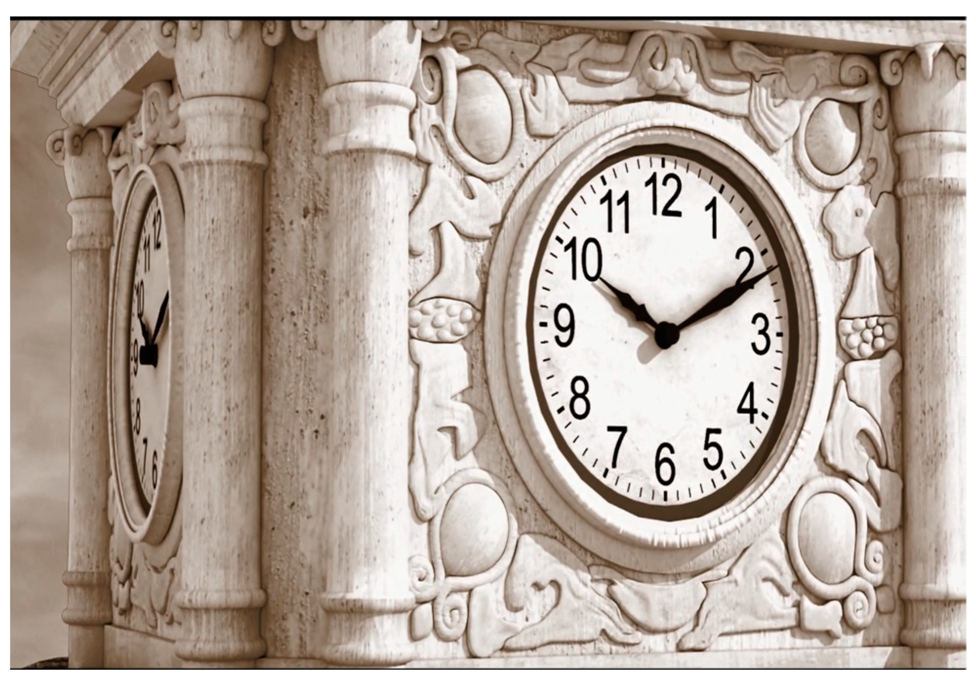
On the basis of the complete component data of the bell tower, a “family” component was directly created for this building. Figure 17 displays the structure of the bell tower generated using these data.
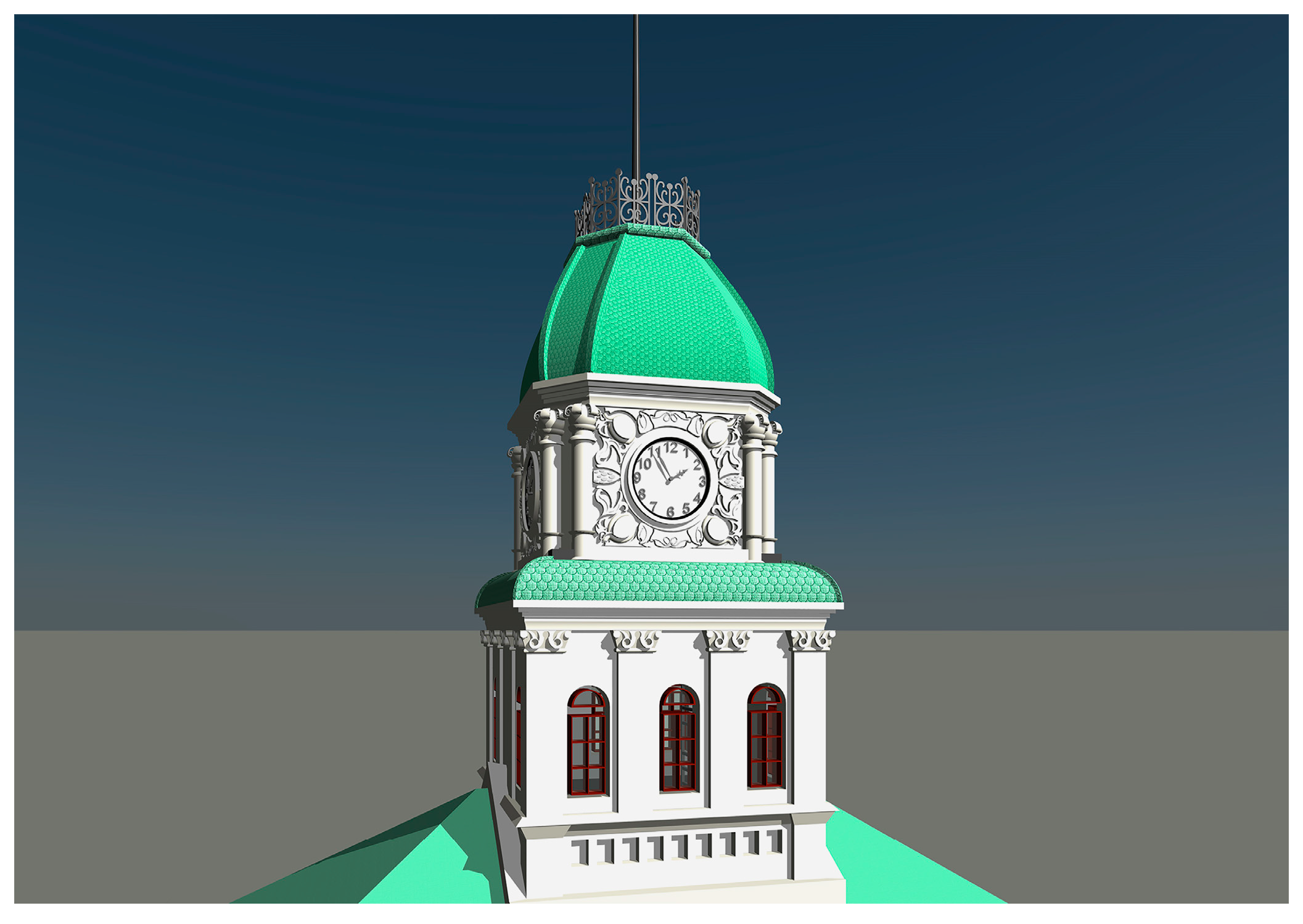
For the incomplete part of the data, the component “family” of the former site of the provisional Senate was loaded into the BIM of the bell tower structure, and its component “family” parameters were adjusted. The digital restoration of the clock tower BIM is presented in Figure 18.

5. Discussion

The interactive method of 3D laser scanning technology and BIM technology used for information collection was compared with manual surveying and mapping information acquisition technology based on drawing files, digital shooting information acquisition technology, and 3D laser scanning information acquisition technology.
As outlined in Table 3, this study presents a comprehensive evaluation and comparison of each approach’s strengths and weaknesses based on various criteria, including information recording ease, time cost, information recording authenticity, accuracy, operability, and stability, as well as training costs and constraints. The interactive method of 3D laser scanning technology and BIM technology utilized in this project has facilitated the preservation of more precise and realistic information compared to other techniques. Furthermore, this method is time-efficient, promotes visualization, and offers a valuable alternative in cases where manual mapping is infeasible. While each approach has its own suitable application scenario, it is the researcher’s responsibility to accurately assess which method to use and validate it as technology advances.
All modern Chinese architectural heritage is the result of cooperation among all elements of the construction work based on ideas, motives, and purposes of the specific space and time. As such, it is the carrier of both materials and ideas and, therefore, not isolated from its historical background. To ensure historical accuracy, it is necessary to record and identify information on various architectural elements and their evolution over time. To achieve this goal, it is essential not only to preserve and archive the drawings, photos, and textual information from each historical period but also to use 3D reconstruction systems to better perceive the historical changes in modern architectural heritage on the temporal scale.
This project focused on the former site of the provisional Senate of the National Government as an example and used BIM technology to promote the digitalization of Chinese architectural heritage. Our completed historical building model contains information related to the buildings in space and covers the whole life cycle of the architectural heritage, recording each repair and change over time, including the damage caused by natural disasters. This is a very valuable tool for studying Chinese architectural and cultural heritage.
In the era of digital technology, this work represents an operational exploration that offers new opportunities for recording and preserving architectural heritage, with several advantages, including ensuring the accuracy of the information, promoting the continuity of historical research, preserving urban culture, advancing professional fields, and raising public awareness about the protection and utilization of modern architectural heritage. Moreover, because of the scalability of digital technology, our model facilitates the exploration of more diversified functions, such as cloud computing, high-precision modeling, and AI technology. However, it is crucial to note that digital technology is rapidly evolving and may only address a fraction of current issues. Nonetheless, through a collaborative and interdisciplinary research approach and an open-sharing initiative, our study can significantly contribute to advancing the digital technology application in architectural heritage.

6. Conclusions

The growing awareness of sustainability and advancements in digital technologies have led to increasing demand for accurate and reliable architectural heritage information across various industries. Consequently, there is a growing requirement to ensure the authenticity of such information. The construction of a comprehensive and public-oriented life-cycle information management system for architectural heritage, as described in information surveying and mapping, is a complex and enormous project. BIM technology is mainly used to make attempts and explorations in collecting and processing cultural heritage building information. Establishing BIM compensates for the shortcomings of traditional 3D models that cannot obtain attribute information. Thus, BIM technology enhances the digital documentation and preservation of architectural heritage information to a greater extent. The digital restoration of modern architectural cultural heritage using BIM fills the gap left by difficult-to-obtain or undocumented data and, in doing so, helps restore damaged historic buildings. The study mainly focuses on establishing the 3D model of historic buildings using BIM technology, proposing a digital virtual restoration method based on “family” components. In that respect, more research should be conducted to achieve digital restoration of severely damaged historic buildings lacking historical materials and relevant similar “family” components.
Discussing new technologies in the context of urban heritage preservation has been rewarding. As in the relationship between urban renewal and urban heritage, the “new” and “old” are complementary and interdependent, similar to light and shadow. They do not exist independently but mutually enrich and fulfill one another. The purpose of this study was to promote the sustainable development of urban renewal and enable cultural heritage to transcend temporal barriers, allowing more people and new generations to share information across different time periods.

Author Contributions

Conceptualization, Y.C.; methodology, Y.C.; formal analysis, Y.C.; investigation, Y.C. and X.S.; resources, Q.Z.; data curation, Q.Z.; writing—original draft preparation, Y.C.; writing—review and editing, Y.C., Y.W. and N.A.; visualization, Y.C., Y.W. and X.S.; supervision, Q.Z.; project administration, Y.W. and N.A.; funding acquisition, Q.Z. All authors have read and agreed to the published version of the manuscript.

Funding

This research was funded by the National Natural Science Foundation of China, grant number 51778123. Project title: Research on reinforced concrete building protection technology in early modern China.

Institutional Review Board Statement

Not applicable.

Informed Consent Statement

Not applicable.

Data Availability Statement

Not applicable.

Conflicts of Interest

The authors declare no conflict of interest.

References

  1. Sun, L. Drawing the identity of architect: Liu Jipiao as an artistic architect in the late 1920s China. Front. Archit. Res. 2021, 10, 584–597. [Google Scholar] [CrossRef]
  2. Xu, S. Emergence of “Architecture”: In the Reform Years of Late Qing Dynasty. In Routledge Handbook of Chinese Architecture; Routledge: London, UK, 2023; pp. 235–250. [Google Scholar] [CrossRef]
  3. Zhang, Y.; Dong, W. Determining minimum intervention in the preservation of heritage buildings. Int. J. Archit. Herit. 2021, 15, 698–712. [Google Scholar] [CrossRef]
  4. Leon, I.; Pérez, J.J.; Senderos, M. Advanced techniques for fast and accurate heritage digitisation in multiple case studies. Sustainability 2020, 12, 6068. [Google Scholar] [CrossRef]
  5. Münster, S.; Utescher, R.; Ulutas Aydogan, S. Digital topics on cultural heritage investigated: How can data-driven and data-guided methods support to identify current topics and trends in digital heritage? Archit. Herit. 2021, 5, 25. [Google Scholar] [CrossRef]
  6. Barsocchi, P.; Bartoli, G.; Betti, M.; Girardi, M.; Mammolito, S.; Pellegrini, D.; Zini, G. Wireless sensor networks for continuous structural health monitoring of historic masonry towers. Int. J. Archit. Herit. 2021, 15, 22–44. [Google Scholar] [CrossRef]
  7. Almodovar-Melendo, J.M.; Cabeza-Lainez, J.M. Environmental features of Chinese architectural heritage: The standardization of form in the pursuit of equilibrium with nature. Sustainability 2018, 10, 2443. [Google Scholar] [CrossRef]
  8. Sacks, R.; Eastman, C.; Lee, G.; Teicholz, P. BIM Handbook: A Guide to Building Information Modeling for Owners, Managers, Designers, Engineers and Contractors; John Wiley & Sons: Hoboken, NJ, USA, 2011. [Google Scholar]
  9. Ma, Z.; Yuan, R. Integrated application of BIM and GIS: An overview. Procedia Eng. 2017, 196, 1072–1079. [Google Scholar] [CrossRef]
  10. Di, Y.; Wu, C. A Study on the Whole Life Cycle Management of Architectural Heritage and Building Information Modeling—An Example of the South Outer Gate of Chageo Temple, Cambodia. New Archit. 2013, 4, 4. [Google Scholar] [CrossRef]
  11. Fadli, F.; Al Saeed, M. Digitizing vanishing architectural heritage; The design and development of Qatar historic buildings information modeling [Q-HBIM] platform. Sustainability 2019, 11, 2501. [Google Scholar] [CrossRef]
  12. Moyano, J.; Nieto-Julián, J.E.; Lenin, L.M.; Bruno, S. Operability of point cloud data in an architectural heritage information model. Int. J. Archit. Herit. 2022, 16, 1588–1607. [Google Scholar] [CrossRef]
  13. Bianco, A. Geomatics and Architectural Heritage: A Multi-layer Interactive Map of Tuscia-Italy. Int. J. Archit. Urban Dev. 2018, 8, 15–22. [Google Scholar]
  14. Masciotta, M.G.; Morais, M.J.; Ramos, L.F.; Oliveira, D.; Sánchez-Aparicio, L.J.; González-Aguilera, D. A digital-based integrated methodology for the preventive conservation of cultural heritage: The experience of HeritageCare project. Int. J. Archit. Herit. 2021, 15, 844–863. [Google Scholar] [CrossRef]
  15. Soler-Estrela, A. Cultural landscape assessment: The rural architectural heritage (13th–17th Centuries) in Mediterranean Valleys of Marina Alta, Spain. Buildings 2018, 8, 140. [Google Scholar] [CrossRef]
  16. Höll, T.; Holler, G.; Pinz, A. A novel high accuracy 3D scanning device for rock-art sites. Int. Arch. Photogramm. Remote Sens. Spat. Inf. Sci. 2014, 40, 285. [Google Scholar] [CrossRef]
  17. Alexander, C.; Pinz, A.; Reinbacher, C. Multi-scale 3D rock-art recording. Digit. Appl. Archaeol. Cult. Herit. 2015, 2, 181–195. [Google Scholar] [CrossRef]
  18. Mascardi, V.; Briola, D.; Locoro, A.; Grignani, D.; Deufemia, V.; Paolino, L.; Bianchi, N.; de Lumley, H.; Malafronte, D.; Ricciarelli, A. A holonic multi-agent system for sketch, image and text interpretation in the rock art domain. IJICIC 2014, 10, 81–99. [Google Scholar]
  19. Briola, D.; Deufemia, V.; Mascardi, V.; Paolino, L. Agent-oriented and ontology-driven digital libraries: The IndianaMAS experience. Softw. Pract. Exp. 2017, 47, 1773–1799. [Google Scholar] [CrossRef]
  20. Borri, A.; Corradi, M. Architectural heritage: A discussion on conservation and safety. Heritage 2019, 2, 631–647. [Google Scholar] [CrossRef]
  21. Della Torre, S. Italian perspective on the planned preventive conservation of architectural heritage. Front. Archit. Res. 2021, 10, 108–116. [Google Scholar] [CrossRef]
  22. Castellano-Román, M.; Pinto-Puerto, F. Dimensions and levels of knowledge in heritage building information modelling, HBIM: The model of the Charterhouse of Jerez (Cádiz, Spain). Digit. Appl. Archaeol. Cult. Herit. 2019, 14, 00110. [Google Scholar] [CrossRef]
  23. Van Balen, K. The Nara Grid: An Evaluation Scheme Based on the Nara Document on Authenticity. APT Bull. 2008, 49, 39–45. [Google Scholar]
  24. Aloisio, A.; Antonacci, E.; Fragiacomo, M.; Alaggio, R. The recorded seismic response of the Santa Maria di Collemaggio basilica to low-intensity earthquakes. Int. J. Archit. Herit. 2021, 15, 229–247. [Google Scholar] [CrossRef]
  25. Colucci, E.; Noardo, F.; Matrone, F.; Spanò, A.; Lingua, A. High-level-of-detail semantic 3D GIS for risk and damage representation of architectural heritage. Int. Arch. Photogramm. Remote Sens. Spat. Inf. Sci. 2018, 42, 107–114. [Google Scholar] [CrossRef]
  26. Adamopoulos, E.; Volinia, M.; Girotto, M.; Rinaudo, F. Three-dimensional thermal mapping from IRT images for rapid architectural heritage NDT. Buildings 2020, 10, 187. [Google Scholar] [CrossRef]
  27. Del, M.S.T.T.; Tabrizi, S.K. A methodological assessment of the importance of physical values in architectural conservation using Shannon entropy method. J. Cult. Herit. 2020, 44, 135–151. [Google Scholar] [CrossRef]
  28. Milošević, M.R.; Milošević, D.M.; Stanojević, A.D.; Stević, D.M.; Simjanović, D.J. Fuzzy and interval AHP approaches in sustainable management for the architectural heritage in smart cities. Mathematics 2021, 9, 304. [Google Scholar] [CrossRef]
  29. Wang, T.; Zhao, L. Virtual Reality-Based Digital Restoration Methods and Applications for Ancient Buildings. J. Math. 2022, 2200, 2305463. [Google Scholar] [CrossRef]
  30. Spiridonov, A.; Umniakova, N. Problems of Restoration of Historical Fenestration for Providing the Normalized Parameters of the Microclimate of Premises in Ancient Buildings. IOP Conf. Ser. Mater. Sci. Eng. 2020, 753, 022064. [Google Scholar] [CrossRef]
  31. Hmood, K.; Jumaily, H.; Melnik, V. Urban architectural heritage and sustainable tourism. WIT Trans. Ecol. Environ. 2018, 227, 209–220. [Google Scholar] [CrossRef]
  32. Noardo, F. Architectural heritage semantic 3D documentation in multi-scale standard maps. J. Cult. Herit. 2018, 32, 156–165. [Google Scholar] [CrossRef]
  33. Cai, Z.; Fang, C.; Zhang, Q.; Chen, F. Joint development of cultural heritage protection and tourism: The case of Mount Lushan cultural landscape heritage site. Herit. Sci. 2021, 9, 86. [Google Scholar] [CrossRef]
  34. Zhao, C.; Zhang, Y.; Wang, C.C.; Hou, M.; Li, A. Recent progress in instrumental techniques for architectural heritage materials. Herit. Sci. 2019, 7, 36. [Google Scholar] [CrossRef]
  35. Zhang, Y.; Zhang, H.; Sun, Z. Effects of urban growth on architectural heritage: The case of Buddhist monasteries in the Qinghai-Tibet plateau. Sustainability 2018, 10, 1593. [Google Scholar] [CrossRef]
  36. Shu, H.; Yang, M.; Liu, Q.; Luo, M. Study of TiO2-modified sol coating material in the protection of stone-architectural cultural heritage. Coatings 2020, 10, 179. [Google Scholar] [CrossRef]
  37. Vacca, G.; Fiorino, D.R.; Pili, D. A spatial information system (SIS) for the architectural and cultural heritage of Sardinia (Italy). ISPRS Int. J. Geo-Inf. 2018, 7, 49. [Google Scholar] [CrossRef]
  38. Angulo-Fornos, R.; Castellano-Román, M. HBIM as support of preventive conservation actions in heritage architecture. Experience of the renaissance quadrant facade of the cathedral of Seville. Appl. Sci. 2020, 10, 2428. [Google Scholar] [CrossRef]
  39. ISO 23386:2020; Building Information Modelling and Other Digital Processes Used in Construction—Methodology to Describe, Author and Maintain Properties in Interconnected Data Dictionaries. International Organization for Standardization: Geneva, Switzerland, 2020. Available online: https://www.iso.org/standard/75401.html. (accessed on 25 March 2020).
  40. ISO 12006-2:2015; Building Construction—Organization of Information about Construction Works—Part 2: Framework for Classification. International Organization for Standardization: Geneva, Switzerland, 2015. Available online: https://www.iso.org/standard/61753.html. (accessed on 8 May 2015).
  41. ISO 19650-1:2018; Organization and Digitization of Information about Buildings and Civil Engineering Works, Including Building Information Modelling (BIM)—Information Management Using Building Information Modelling—Part 1: Concepts and Principles. International Organization for Standardization: Geneva, Switzerland, 2018. Available online: https://www.iso.org/standard/68078.html. (accessed on 15 March 2018).
  42. EU BIM Task Group. Handbook for the Introduction of Building Information Modelling. The European Public Sector, 2017. Available online: http://www.eubim.eu/downloads/EU_BIM_Task_Group_Handbook_FINAL.PDF (accessed on 15 March 2018).
Figure 1. The process of protection of architectural heritage (drawn by the author).
Sustainability 15 07276 g001
Figure 2. The framework of BIM (drawn by the author).
Sustainability 15 07276 g002
Figure 3. The Chinese modern architecture digital library. ((a) front-end homepage of the digital library; (b) the former site of the Nanjing branch of the Bank of Communications; (c) Dahua Theater; (d) Yangtze Hotel; (e) the former site of the National Government Ministry of Foreign Affairs building). (Source: the author’s studio).
Sustainability 15 07276 g003
Figure 4. The digital model of the building of the former site of the provisional Senate of the National Government. ((a) Main elevation; (b) aerial view; (c) entrance view; (d) east elevation; (e) south elevation; (f) west elevation; (g) north elevation). (Source: drawn by the author).
Sustainability 15 07276 g004
Figure 5. The building of the former site of the provisional Senate. (a) Historical photograph; (b) current photograph of the building; (c) internal corridor; (d) historical staircase inside the building; (e) the lawn outside the building; (f) bell tower outside the building; (g) the general plan of the building). (Source: the author’s studio).
Sustainability 15 07276 g005
Figure 6. Point cloud data of the provisional Senate of the Nanjing National Government building: (a) top side; (b) front side. (Source: the authors).
Sustainability 15 07276 g006
Figure 7. Proposed establishment process of BIM based on point cloud data. (Source: the author’s studio).
Sustainability 15 07276 g007
Figure 8. A partial plan view of the bell tower. (Source: drawn by the author).
Sustainability 15 07276 g008
Figure 9. The front and side elevations of the bell tower processed following the BIM method. ((a) front and (b) side). (Source: the author’s studio).
Sustainability 15 07276 g009
Figure 10. A sectional view of the bell tower. (Source: the author’s studio).
Sustainability 15 07276 g010
Figure 11. The plan for the 2nd and 3rd floors of the bell tower. ((a) 2nd floor; (b) 3rd floor) (source: the author’s studio).
Sustainability 15 07276 g011
Figure 12. The plan of the 4th and 5th floors of the bell tower. ((a) 4th floor; (b) 5th floor) (source: the author’s studio).
Sustainability 15 07276 g012
Figure 13. The plan of the 6th floor and the bell tower roof. ((a) 6th floor and (b) roof) (source: the author’s studio).
Sustainability 15 07276 g013
Figure 14. The sub-column in the case-study bell tower. (Source: drawn by the author).
Sustainability 15 07276 g014
Figure 15. The main building of the former site of the provisional Senate. ((a) the overall structure of the building, and (b) the overall structure of the bell tower). (Source: the author’s studio).
Sustainability 15 07276 g015
Figure 16. The dismantled view of the bell tower of the building (source: drawn by the author).
Sustainability 15 07276 g016
Figure 17. The structure of the bell tower, the building of the former site of the provisional Senate (source: the author’s studio).
Sustainability 15 07276 g017
Figure 18. The digital restoration of the BIM (source: drawn by the author).
Sustainability 15 07276 g018
Table 1. Three levels of proposed standardized information of architectural heritage digital library (source: drawn by the author).
Macro LevelMeso LevelMicro Level
City and ContextBasic InformationLocation
Date of Construction
Style
Architect
Construction Team
Owners
Data Collection StandardsFile Naming
AUTOCAD Drawing
Revit Model
GIS Information
Photography Principles
Text Content
Types of Chinese Modern ArchitectureLandscape
Military
Administration
Educational
Residential
Industrial
Commercial
Transportation
Memorial
Cultural
Medical
Engineering Structures
Scientific Research
Religious
Value Assessment CriteriaArtistic Value
Historical Value
Social Value
Scientific Value
Use Value
ChangesStyle
Function
Ownership
Historic InformationHistoric style
Stories
Celebrities
Drawings Database2D Drawing Library
3D Model Library
Current InformationCurrent state
Ownership
Use Status
Building Structure Systems
Table 2. The information classification system of design and construction.
ProcessMacro Level and Meso Level Micro Level
Scheme designBackground Value judgment
Geography, HumanitiesSingle location
Single buildingPedestalHigh platform, stone steps
RoomStructureSurface width, depth, column foundation, column body, bucket arch, beam, square column, etc.
EnclosingDoors, windows, baffles, etc.
MaterialForm, component
roofWood, brick, stone
Table 3. Comparison of methods.
MethodsAdvantageDisadvantage
Manual surveying and mapping information acquisition technology based on drawing filesThe most prominent feature of the traditional measurement method is to use a single point for measurement, mainly by measuring the distance between feature points, to draw a two-dimensional map of the building.In manual surveying and mapping, personnel tends to make numerous subjective assumptions based on their habits, such as vertical and parallel constraints, or according to the law of construction, the survey results are summarized and simplified so that many actual structural deviations, such as deformation, defects, processing differences, etc., are deliberately corrected.
Digital shooting information acquisition technologyThis method greatly simplifies the surveying and mapping work of large sample drawings of the components, and the drawn lines genuinely reflect the status quo of components.The information recording method of digital photography can only express the elevation composition and color of buildings with historical features but cannot record the structure, size, and materials of buildings. Therefore, digital photos are often used as the basic work for collecting landscape building information to provide a reference for future information protection work.
Laser scanning information acquisition technologyThe registration precision is high, the operation is convenient, and the result is reliable.It is vulnerable to environmental conditions and susceptible to cumulative errors.
The interactive method of 3D laser scanning technology and BIM technologyIt is high accuracy, time-saving, enhanced visualization, and easy maintenance of dimensions for real-time observation.The cost of BIM technology, including specialized software, trained personnel, and equipment, can be high.
Disclaimer/Publisher’s Note: The statements, opinions and data contained in all publications are solely those of the individual author(s) and contributor(s) and not of MDPI and/or the editor(s). MDPI and/or the editor(s) disclaim responsibility for any injury to people or property resulting from any ideas, methods, instructions or products referred to in the content.