Abstract
In recent years, floods and climate-induced cataclysms have caused significant annual damage to livelihoods worldwide, with limited research on their vulnerability, impact, resilience, and long-term adaptation strategies in developing countries. In the South Indian State of Kerala, the major flood in 2018 caused immense economic losses in the low-lying and densely populated Alappuzha District. While the region has a heightened risk of periodic flooding, the considerable destruction of buildings and infrastructure highlights the need for effective solutions for flood resilience in the existing housing stock and new construction. In this context, this study examines flood resilience in the built environment of Alappuzha, focusing on flood vulnerability, building practices, and potential approaches suitable for the region that the current literature does not address. This study employs a qualitative research approach to understand current trends in adaptation strategies and the influencing socioeconomic and cultural factors. The study employs various data collection methods, including interviews, site observations, and content analyses of existing government reports, journal articles, and popular media sources. The findings indicate that although there are three types of established flood resilience techniques (static elevated, floating, and amphibious structures), their suitability for the low-lying areas of Alappuzha depends on the geographic, climatic, socioeconomic, and cultural contexts. Stilted houses have become the most common construction method, in response to climatic and socioeconomic conditions. In addition, the findings highlight the bounce-forth resilience quality of amphibious building techniques and suggest further exploration by integrating them with local technologies and materials. The study concludes that a comprehensive approach is needed that integrates traditional and modern knowledge and practices in disaster risk reduction and management to enhance the resilience of the built environment to flooding.
1. Introduction
Climate-induced cataclysms present major risks and significant challenges to the built environment, including buildings, infrastructure, and communities. Cities face substantial challenges in dealing with the consequences of climate-induced cataclysms, which are exacerbated by the increasing frequency and severity of extreme weather events, including hurricanes, typhoons, cyclones, heavy rainfall, and storms [1,2]. Globally, low-lying coastal cities are susceptible to flooding and changing ecological conditions that cause damage, destruction, and disruption [3,4,5]. Studies have projected that climate change and related factors may amplify the complexity of flooding, potentially engendering substantial societal repercussions.
Floods have consistently been the most frequent and destructive natural hazards in history [6,7,8], destroying property and human lives. Among the prevalent natural disasters and threats, various standard lists emphasise flooding as an indicator of resilient cities, owing to their widespread occurrence across multiple countries [9,10]. The occurrence of floods has increased significantly over the last two decades, posing significant obstacles for governments to mitigate physical damage to buildings and produce effective disaster preparedness, including urban regeneration strategies [11,12]. Due to rising sea levels and storm surges, susceptibility to flooding has created increasing concerns for exacerbating social inequalities, diseases, widespread displacement, economic repercussions, loss of homes, and vulnerabilities within communities [5,13,14,15]. Consequently, an increasing focus has been on adaptation and mitigation strategies in built environments.
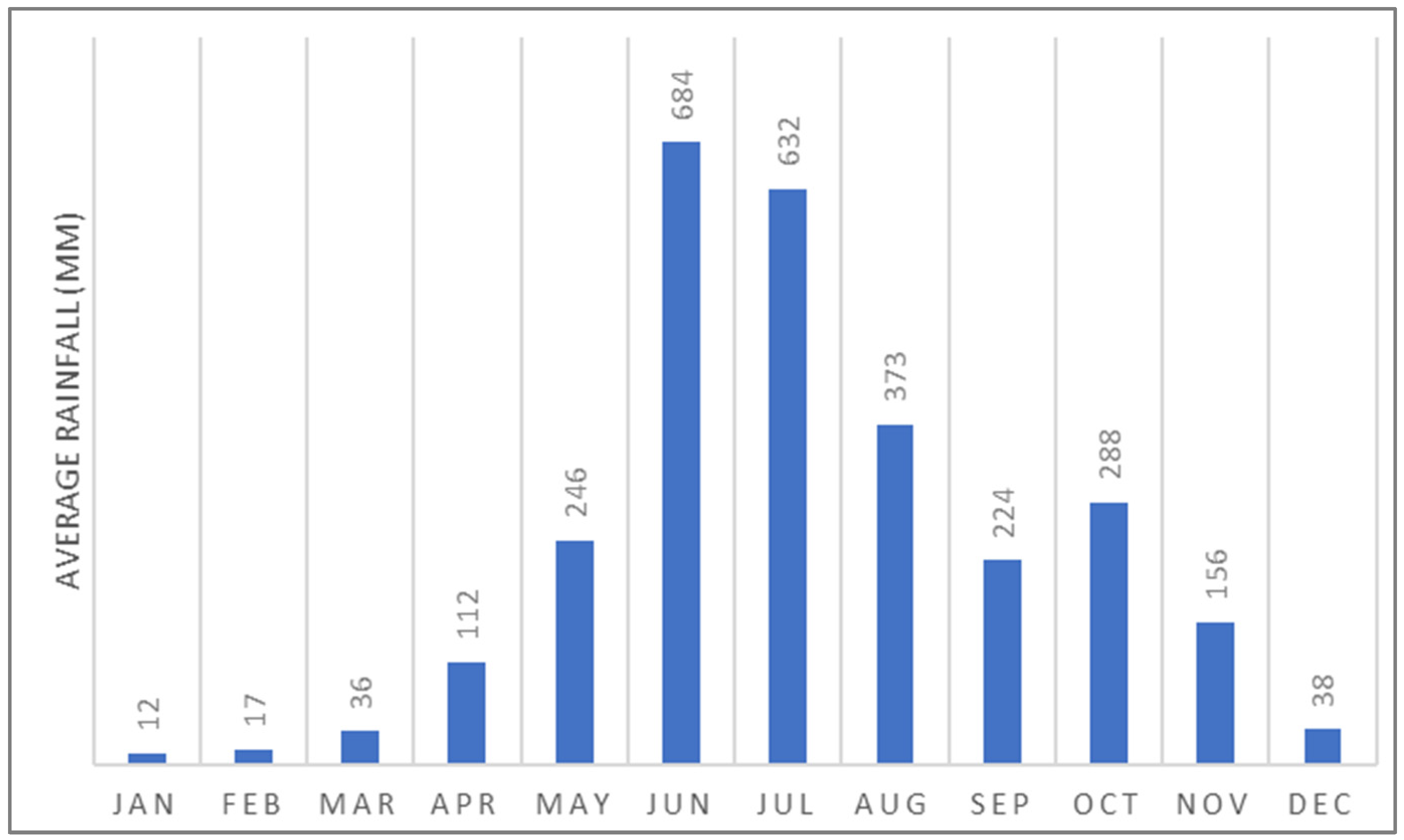
Over the past five years, Kerala in India has experienced several devastating floods. Kerala receives extremely high annual average rainfall throughout its two consecutive rainy seasons, spanning six months from mid-May to early November [16] (Figure 1). Although Kerala is not typically subjected to floods compared with the rest of India [17], flood incidents have become more frequent and severe in recent years. In August 2018, a significant flood occurred that was the most severe in the century since the 1924 flood [18]. The estimated damage caused by the 2018 flood was approximately 3.8 billion USD [2]. This was followed by a lesser-magnitude flood in August 2019 and another major flood in 2020, creating widespread losses [17].

Figure 1.
Annual average rainfall in Kerala (source: authors).
Resilience to flooding is a critical issue, particularly considering the effects of climate change in low-income cities, where vulnerable populations are disproportionately affected by the devastating impacts of inundation. While previous studies have focused on vulnerability assessment and the effect of flooding on the built environment, there is a lack of research on the resilience of the built environment to flooding through construction practices and other adaptation measures. Several studies have highlighted various techniques for flood-resistant buildings and infrastructure in flood-prone areas in developed countries [14,19,20,21]. Nonetheless, there is a need for research examining the resilience of the built environment to flooding in the context of Alappuzha District in Kerala, India.
Understanding the factors contributing to flood resilience is essential. As the potential for climate-induced cataclysm increases in low-lying cities, what resilient design strategies and construction practices exist in Alappuzha to ameliorate flooding? It is hypothesised that resilience to flooding in the Alappuzha District in Kerala adapts to the specific socioeconomic and cultural context, which influences the design and construction of buildings, the use of materials and support systems, and the level of community preparedness. The objective of this study is to comprehensively explore the resilience of the built environment to flooding, including the existing housing stock and the suitability of current flood resilience techniques.
This study is essential to the international community because of the limited global focus on low-lying areas in South India in the face of climate change-induced weather events. Alappuzha’s struggle with flooding presents a practical case study for understanding the implications of climate change on the built environment, and for identifying adaptive strategies that can be implemented in communities facing similar challenges. To achieve the United Nations’ Sustainable Development Goals, especially Goal 11 (Sustainable Cities and Communities) and Goal 13 (Climate Action), measures must be taken to improve the resilience of urban environments. As such, this research may help to further these objectives by influencing practices and policies in other susceptible areas.
2. Literature Review
Over the past two decades, the concept of resilience has gained importance in urban planning, engineering, and environmental psychology. Resilience, a term that emerged in the 1970s, has a variety of definitions emanating from governmental and non-governmental agencies, as well as scholars in the field of urban planning. Although resilience is malleable, with diverse interpretations from practitioners [22], most definitions in urban settings pertain to disaster risk reduction (DRR) [23]. The United Nations Office for Disaster Risk Reduction (UNISDR) defines resilience as “the ability of a system, community, or society exposed to hazards to resist, absorb, accommodate, adapt to, transform, and recover from the effects of a hazard in a timely and efficient manner” [24] (p. 3). Resilience in the built environment promotes sustainable and inclusive urban development through the ability of physical infrastructure, urban systems, and communities to withstand, adapt to, and recover from various stressors, shocks, and disturbances [25]. In addition, resilient built environments exhibit flexibility and adaptability to dynamic conditions. The concept represents a holistic approach to the challenges of an uncertain future, “bridging the gap between disaster risks and the adaptation to climate change so that the people living and working in cities–particularly the poor and vulnerable–survive and thrive no matter what stresses or shocks they encounter” [25] (p. 3).
2.1. Engineering Resilience and Ecological Resilience
Studies have analysed the origin and evolution of the types of resilience based on earlier works that defined the distinction between engineering resilience and ecological resilience [26]. While they share similarities in their goals of promoting stability and adaptability, they differ in focus, scope, and underlying principles [27]. Engineering resilience refers to the ability of physical infrastructure and engineered systems to absorb shocks, disruptions, or changes and return to a stable state within a relatively short time. This is measured in terms of the time a system takes to return to its original steady state after a disturbance. In contrast, ecological resilience is measured in terms of the magnitude of disturbance the system can absorb before it changes its structure [28]. Ecological resilience encompasses the dynamic interactions among living organisms, habitats, and ecological processes that enable ecosystems to absorb changes, recover from disturbances, and adapt to shifting environmental conditions [29]. This concept highlights the interconnectedness and complexity inherent in natural systems by considering elements such as biodiversity, habitat connectivity, and ecosystem dynamics. Davoudi [30] emphasised that ecological resilience rejects the notion of a single, stable equilibrium, in contrast to the tenets of engineering resilience. Nonetheless, both types of resilience are similar, as confirmed by the presence of a state of equilibrium. While engineering resilience should bounce back to a pre-existing equilibrium, ecological resilience is expected to bounce forth to a new one.
2.2. Resilience and Sustainability Paradox
Another view of resilience in relation to sustainability has been widely discussed in urban planning and policies. Resilience in the built environment is closely linked to sustainability. Studies have identified diverse interpretations in various policy and decision-making contexts. Sustainability is often perceived through Brundtland’s definition of sustainable development towards our shared future, whereas resilience is a systems approach that emphasises capacity building, hazard response, and recovery rate [22]. Major and Al-Nabet [31], in their study on the paradox of urban resilience, argued that resilience had gained traction in urban planning but failed to achieve the same level of acceptance as sustainability among built environment professionals.
A significant reason for this disparity in acceptance is that the concept of sustainability and its implications are easily understood. In contrast, resilience is more convoluted, even though both essentially mean the same thing. By definition, a sustainable system should be resilient, and vice versa, while considering the interdependencies and interactions between social, economic, environmental, and institutional factors. Sustainability and resilience in the built environment can be integrated through risk-informed sustainable development [22,32]. Therefore, both can be crucial in addressing environmental challenges while promoting long-term viability. They also involve enhancing the capacity of communities and infrastructure to withstand and adapt to various stressors and disturbances.
2.3. Flood Resilience Approaches in the Built Environment
Two primary approaches have been proposed for flood resilience [33]. The first perspective suggests that buildings, infrastructure, or systems can be made resilient by fully developing mechanisms to evade flooding through design interventions. On the other hand, the second viewpoint states that resilience can be achieved by accepting flooding as an inevitable reality and adjusting life and the physical environment to partly contain the flood. Both options present unique challenges and require careful consideration when selecting the most efficient approach.
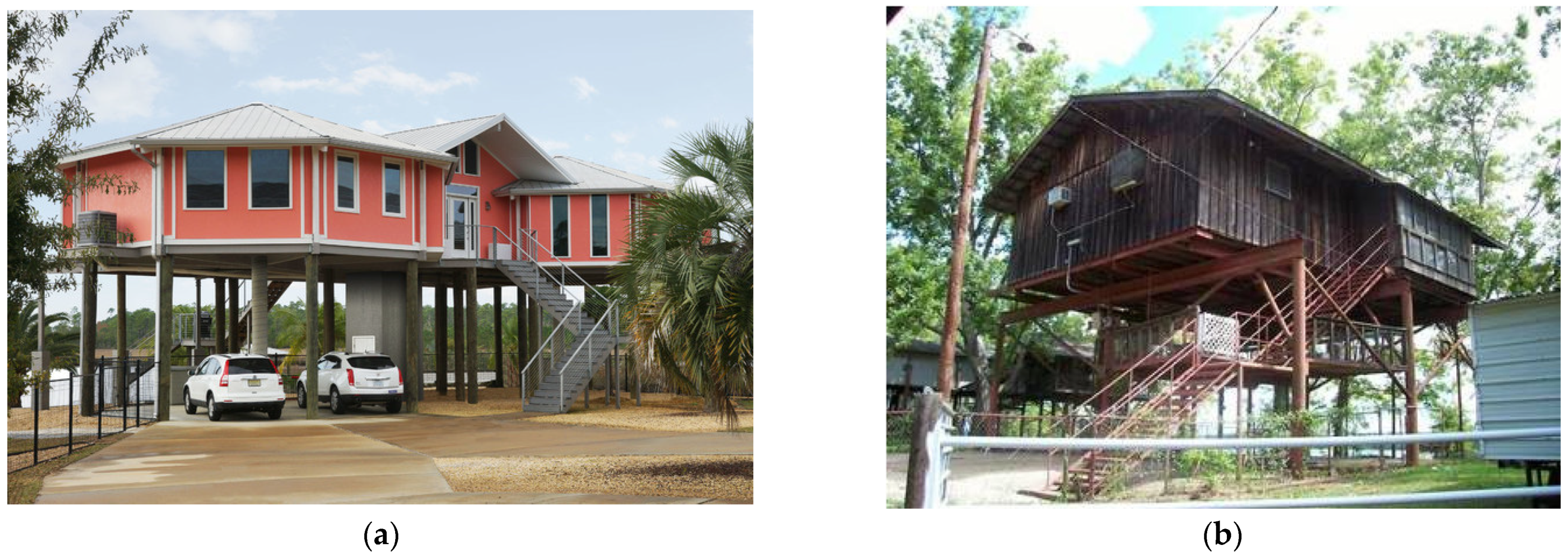
The first approach has been widely discussed in the literature. Stilted houses are the most commonly adopted solution for mitigating the impact of flooding on residential structures (Figure 2). Many Southeast Asian areas, such as the Chao Phraya Basin in Thailand, have historically depended on stilt houses to avoid flooding. Elevating houses has become a regulatory requirement to retain eligibility for flood insurance in parts of Louisiana in the aftermath of Hurricanes Katrina and Rita [34]. However, stilted houses may seem incongruous in regions where such construction practices are not vernacular. In New Orleans, permanently elevating dwellings has practical limits that hinder accessibility to living areas and create inconveniences in daily life. This method may lead to a loss of neighbourhood characteristics, impacting social relationships within the community.
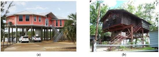
Figure 2.
(a) Hurricane-resistant stilt house in New Orleans [35]. (b) Permanently elevated house [34].
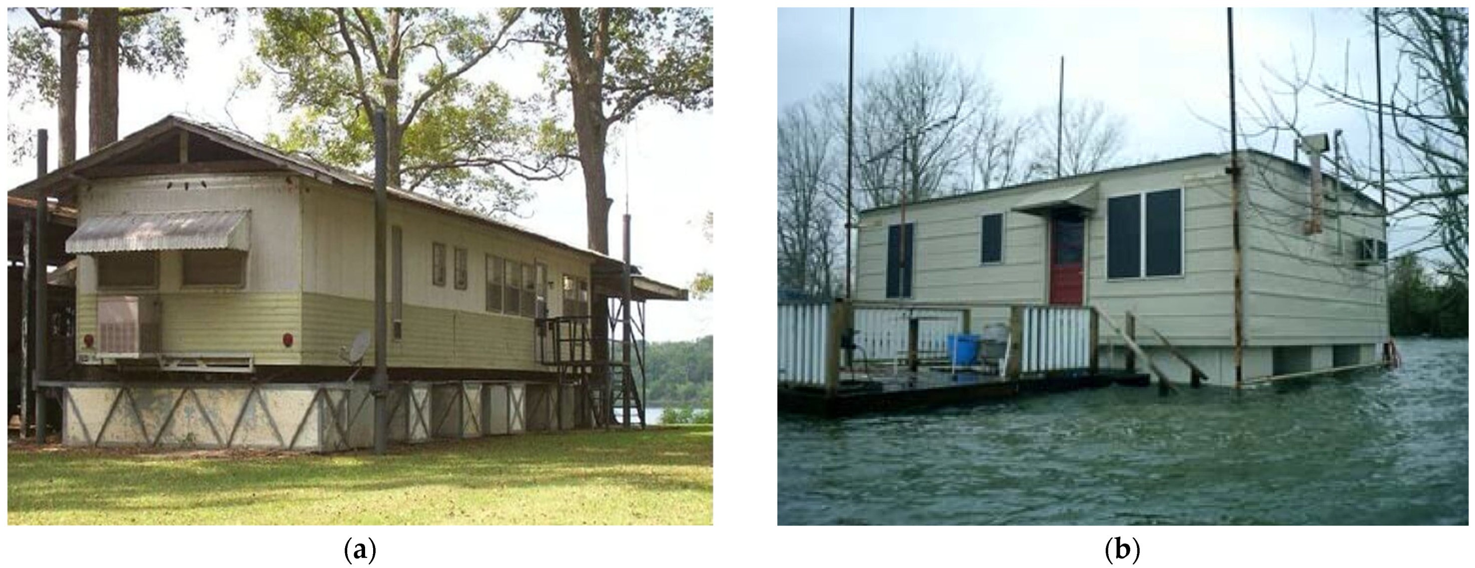
Furthermore, several studies have explored the concept of amphibious houses as flood-resilient buildings [19,34]. An amphibious house is a construction with a buoyant foundation that remains above the water level and floats during floods but does not float permanently [21,36]. Many studies have proposed the possibility of utilising the concept behind floating docks and boats, which could allow houses to rest close to the ground under normal conditions and rise as much as necessary in the case of floods (Figure 3). Amphibious foundations are proven, low-cost, low-impact flood protection strategies that can increase the resilience of a flood-prone community in the face of a disaster [20]. In addition, amphibious houses are accessible by both roads and boats. Therefore, this amphibious concept has the potential to overcome almost all of the limitations highlighted for the others.

Figure 3.
(a) Amphibious house with Styrofoam foundation under normal dry conditions. (b) Amphibious house floating with flooding level [34].
A floating structure is another type of building specifically engineered to withstand floods. Unlike amphibious houses, a floating home is a permanent dwelling equipped with a flotation system, anchored in a fixed position, and lacking navigational tools [37]. These innovative structures offer unique solutions to the challenges posed by rising sea levels, flood-prone areas, and limited land availability in the coastal and waterfront environments. One of the main advantages of floating buildings is their flexibility and adaptability to changes in water levels and environmental conditions [21]. The buildings remain unaffected by extreme flooding because they are not physically located on the ground [34]. Although there is growing interest in experimentation with floating architectures, it is essential to note that access to floating structures can be difficult during extremely low or very high water levels [38].
2.4. The Built Environment and Flooding
Although flooding may result from heavy rainfall, storm surges, and overflowing rivers, studies indicate that built environment’s characteristics significantly impact the extent of damage sustained by communities [39]. Urbanisation and land-use changes are significant factors contributing to hazard, exposure, and vulnerability (H-E-V), owing to their impact on urban surface hydrological characteristics [40,41]. Urban expansion patterns and types, such as edge expansion and leapfrogging, can affect the risk level, as infilling has a weaker positive correlation with flood hazards [42]. Construction activities affect surface infiltration, evapotranspiration, and runoff, exacerbating the frequency and duration of urban flooding [43].
Moreover, the spatial and temporal patterns of urban flooding are influenced by land-use allocation ratios [44,45]. The impact of land-use changes on urban flood disasters is a complex issue influenced by various natural, social, and economic factors. Simulation studies that examined the variability between cultivated, forest, green land, and construction land areas revealed different effects, indicating the need for optimisation to minimise the probability of future urban flood disasters [41]. Different land-use scenarios (natural, economic, and sustainable development) showed that the land-use pattern under the sustainable development scenario is the most conducive to reducing the flood risk [40,41]. In addition, the spatial distribution of water-bearing surfaces, such as the presence of natural or artificial lakes, can significantly influence the flood levels in urban areas and increase risk [42,46]. In addition, the built environment can alter natural waterways and drainage patterns, leading to increased flood hazards.
The implementation of low-impact development (LID) practices, including “rain gardens (RG), green roofs (GR), vegetated swales, infiltration trench (IT), bioretention (BR), rain barrels (RB), permeable pavement (PP), and their combinations”, has been shown to mitigate inundation to some extent, particularly under rainfall events of smaller magnitude [47]. The concept of “sponge cities” in China illustrates an approach to urban design that integrates water management into the urban development, aiming to mitigate flood risk through permeable pavements and other low-impact development strategies [42]. A study focusing on the effects of horizontal and vertical patterns highlighted that the building coverage ratio, building density, proportion of impervious surfaces, proportion of green space, and population density are the most essential factors in creating sponge cities [48]. The integration of blue–green–grey infrastructure, as well as the use of hydrodynamic models and geographic information system (GIS) technologies, can enhance urban resilience to these water-related disasters [49].
Nature-based solutions, including protecting and restoring coastal wetland ecosystems, have naturally reduced the effects of storm surges and associated flood hazards [50,51]. Wetland ecosystems is a term that includes several kinds of terrain, such as wet forests, reedbeds, peat bogs, fens, wet grasslands, and salt marshes [52]. These ecosystems play a vital role in providing habitats for species, reducing the impact of floods, regulating climatic changes, breaking down pollutants, and preventing erosion [53]. Many organisations promote wetlands as a flood management method, since they function like sponges, retaining water during high precipitation and gradually releasing it during dry seasons [52]. Wetland conservation is crucial for ecosystem functioning, affecting groundwater recharge, flood flow alteration, sediment stabilisation, and water quality [52]. However, expanding impervious surfaces, constructions, and other anthropogenic activities lead to habitat loss and degradation. This impacts the biodiversity and the wetlands’ ability to perform their basic functions, such as mitigating floods [51].
Overall, the literature reviewed here underscores the importance of resilience in urban contexts and the need for comprehensive approaches that consider the dynamic nature of environmental challenges and the complex links between social, economic, environmental, and institutional factors.
3. Materials and Methods
The primary objective of this study was to comprehensively explore the resilience of the built environment to flooding, including the existing housing stock and the suitability of current flood resilience techniques. The materials used for this research and the methodological approach are described in this section.
3.1. The Research Design
This study utilised a qualitative case study approach focusing on the Alappuzha District in Kerala, India. Alappuzha served as a formidable context for this investigation because of the recurrent flooding in the geographic area. The primary source of information for this research was derived from existing literature on the subject, including cartographic maps, journals, reports, magazine websites, and other popular media sources. The authors conducted a qualitative literature search on Scopus and Google Scholar, focusing on various data sources. The search outputs were sorted and analysed based on correlation to the related research themes on flood vulnerability and resilience in the study region. In addition, the content analyses of these documents and maps provide a comprehensive understanding of contemporary trends in flood resilience, construction practices, and the built environment.
Due to the limited availability of literature specifically focusing on the built environment and construction practices in Alappuzha, this study incorporated site visits to flood-prone areas. The researchers conducted site observations to collect data on the architectural styles, built environment, flood management strategies, and community resilience practices. In addition, this study incorporated insights from the residents. Semi-structured interviews were conducted with 11 residents who experienced annual floods in Kuttanad, a locality in Alappuzha. The respondents were pre-selected through personal communication with residents who have stayed in the community for over 20 years. Furthermore, the interviews lasted 15–20 min, with the findings transcribed using thematic and content analysis to identify recurring themes. These interviews served as a valuable resource for unravelling the socioeconomic and cultural factors underlying the observed patterns related to flood resilience in the study area. By engaging with the local population, this study aimed to bridge the gap between theory and practice and lived experiences, thereby contributing a nuanced perspective to the overall analysis.
This study draws insights from flood-prone areas worldwide to broaden the scope of potential flood resilience solutions for Alappuzha. The flood resilience techniques implemented in different global contexts were carefully selected and evaluated for their suitability under the specific circumstances of Alappuzha. This comparative approach allows for a more comprehensive understanding of the diverse strategies employed worldwide, as well as their potential applicability within the unique sociocultural and environmental contexts of Alappuzha.
By synthesising information from literature, interviews, and case study analysis, this study sought to provide a holistic assessment of the flood resilience landscape in Alappuzha (Figure 4). The ultimate goal was to provide valuable insights that can inform policymakers, urban planners, and local communities in developing effective strategies to enhance the resilience of the existing housing stock in the face of recurrent floods. Through this multifaceted approach, this research aims to identify challenges and propose practical and context-specific solutions to bolster the resilience of Alappuzha’s built environment against the impacts of flooding.
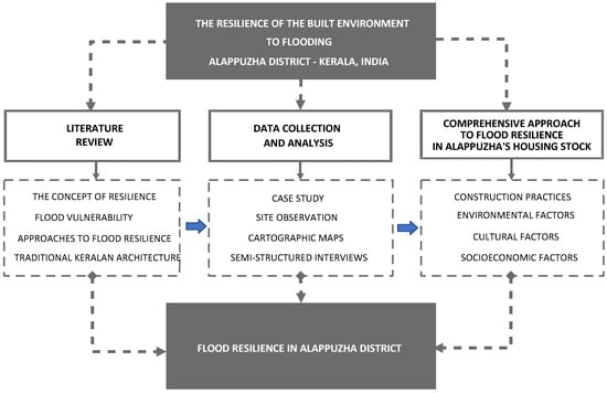
Figure 4.
The research design.
3.2. The Case Study Setting: Alappuzha District in the South Indian State of Kerala
Kerala is one of the southern states of India and is located along its western edge (Figure 5a). The population is approximately 32 million, based on the 2011 census. By 2050, the population of Kerala is projected to double to 64 million [54]. It is the second-most urbanised state among the major states in India, with an average population density of 859 per square metre [55,56]. The average population density along the western coastal belt is over 1000 per square metre [57], leaving the eastern region sparsely populated. Moreover, residential areas have expanded to satisfy the growing demand for housing plots. Therefore, housing density is more concentrated in the coastal regions (Figure 5b).
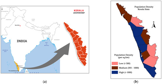
Figure 5.
(a) Location map of Kerala. (b) Population density map of Kerala.
As shown in Figure 6a,b, Kerala’s physiography can be categorised into three primary units: coastal plains, midlands, and hill ranges. The highland region, situated along the eastern border of Kerala, encompasses 48% of the total land area. It has a characteristic of towering Western Ghats, which ascend from the coastal plains to an average elevation of 900 m. Other peaks in the Ghats exceed an elevation of 1800 m, with Anamudi being the tallest mountain in South India. The midlands consist of undulating terrain nestled between the mountains and the lowlands. The midlands comprise around 40% of the total land area and are mostly used for agriculture. The lowlands cover the remaining area, sometimes called the coastal plains.
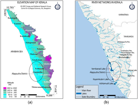
Figure 6.
(a) Elevation map of Kerala [54]. (b) River networks in Kerala [58].
Alappuzha is one of the areas with the lowest elevation and largest number of water bodies in Kerala. Compared to other regions in Kerala, it is the lowest-lying district in the state, with an average elevation of 1 m above mean sea level (MSL). In addition, Alappuzha has an 80 km coastline and is home to 8 of the 44 rivers in Kerala. Being a sandy strip of land intersected by rivers, lagoons, and canals, Alappuzha is widely known as the “Venice of the East”. A large part of Alappuzha lies on the bank of Vembanad Lake, India’s longest lake, covering an area of 230 square kilometres. The elevation of parts of Alappuzha, such as Kuttanad (which is known as the “Rice bowl of Kerala”), ranges between 0.6 m and 2.2 m below MSL. Because of this geographical elevation, the number of houses prone to flooding is also higher in this area.
More than 2.1 million people reside in Alappuzha District, with 1,013,142 males and 1,114,647 females. Approximately 54% of the population reside in urban regions, while 46% dwell in rural areas [56]. A diverse population of Hindus, Muslims, and Christians enriches the social fabric of Alappuzha. According to the National Census of 2011, Alappuzha has a literacy rate of 93.66%, which is above the state average of 90.92% at that time. Per capita income in Alappuzha is also higher than the state average. Road density is high in Alappuzha, making it second among the 14 districts in Kerala in terms of the extent of national and state highways. With regard to the availability of schools, Alappuzha is on par with the state average of 4 schools per 1000 people. Regarding colleges and health institutions, Alappuzha is above the state average.
Although the influence of the caste system is diminishing, it still plays a significant role in shaping social dynamics, since traditional occupations typically determine one’s social status. Approximately 804,471 people are engaged in work activities, including 74.1% classified as primary occupation “earning more than 6 months”, while 25.9% participate in secondary activities that provide a means of subsistence for less than 6 months [56]. On the other hand, approximately 1,323,318 people, or 63% of the total population, are classified as non-working groups [59].
Despite the flooding issues, it is essential to note that Alappuzha is one of the most acclaimed tourist destinations and culturally important districts in Kerala. The abundance of water resources creates the major livelihood activities of the people of Alappuzha, including agriculture, fishing, inland navigation, and the coir industry [59]. In addition, the backwater landscape contributes to the tourism economy, with houseboat excursions, Ayurvedic travel, and cultural events attracting travellers worldwide.
4. Results and Discussion
This section includes the research findings and briefly describes the flood vulnerability of the built environment in Alappuzha, flood resilience in general, and flood resilience in the traditional architecture of Kerala.
4.1. Alappuzha: Flood Vulnerability and Built Environment
Flood inundation is becoming a normal phenomenon during every rainy season in many parts of Alappuzha [60]. This is primarily due to the controlled discharge of water from mega hydroelectric project reservoirs situated upstream of the four major rivers in Alappuzha [18]. When flood warnings are issued before dam shutters are opened, locals are generally prepared for a small amount of flooding. In addition, residents have established routines and adjustment mechanisms to overcome such situations. However, the unanticipated extensive downpours during what was supposedly the declining phase of the first rainy season in 2018 caused significant floods in several parts of Kerala [61]. While most other places were affected only by local rains, Alappuzha had to deal with two issues: (1) rising water levels of the river due to surplus water discharge at unprecedented rates from multiple reservoirs, and (2) rising water levels due to extensive local rain. Fostering resilience should involve improving preparedness and developing better response plans that provide sufficient time for communities and individuals to act.
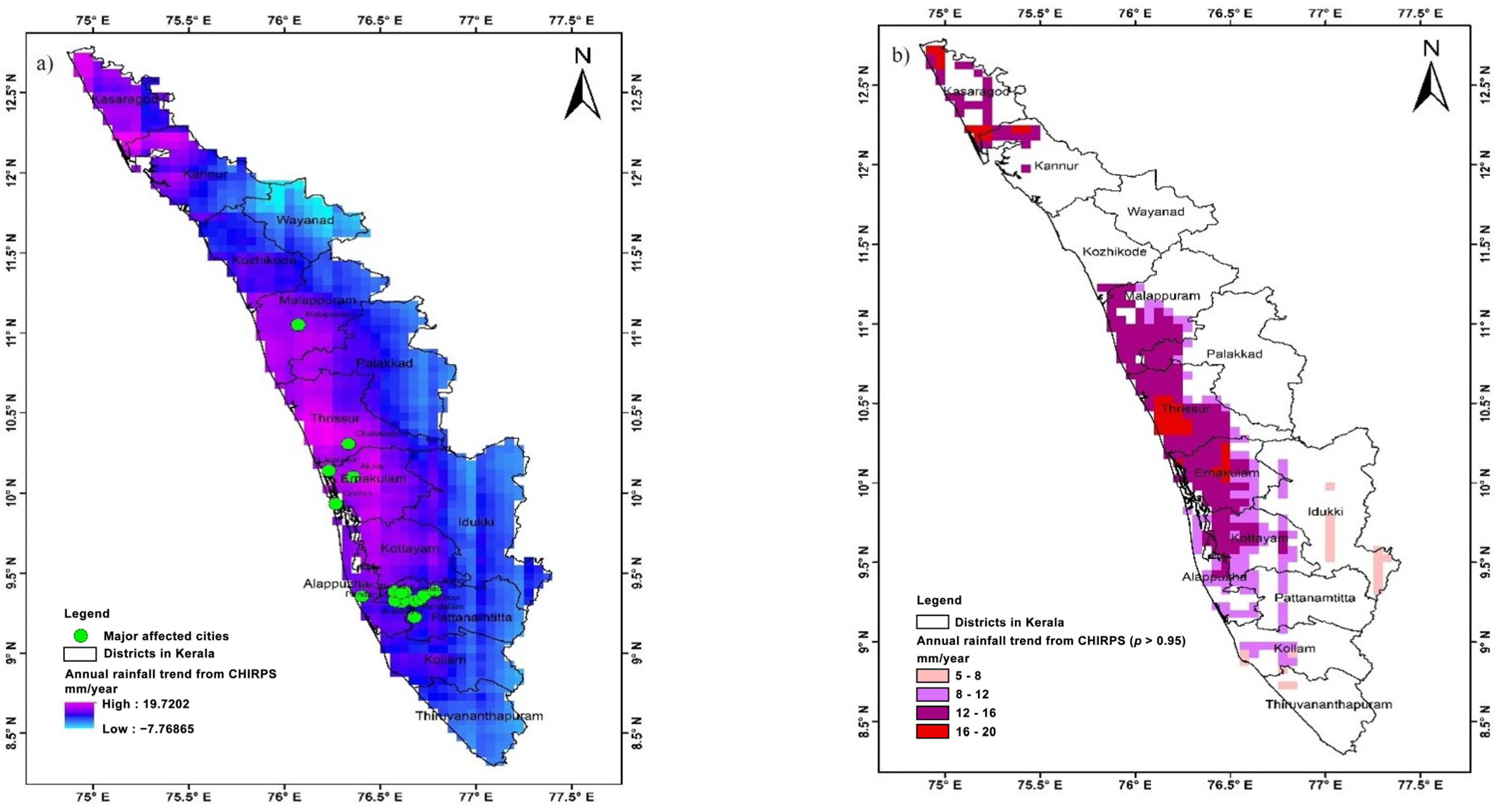
Given the dire consequences on the built environment, there are growing concerns regarding the potential for future flooding. Several studies have focused on mapping techniques to predict the likelihood of flood occurrence in Kerala [62]. Implementing effective early warning systems (EWSs) and flood predictions makes it feasible to prevent 75% of deaths and other injuries [63]. Tiwari et al. [64] proposed an advanced and reliable modelling technique based on rainfall trends from 1981 to 2018, using Sentinel-1 synthetic-aperture radar data and Otsu’s method to map flood inundation areas, with Google Earth Engine (GEE) for Otsu algorithm implementation (Figure 7a,b). The study assessed results by calculating a confusion matrix, comparing submerged water areas, comparing flooded and non-flooded seasons, and analysing historical rainfall patterns. In reference to these maps, Alappuzha was identified as having an elevated risk of flooding. According to the classification system established by the Global Facility for Disaster Reduction and Recovery (GFDRR), the Alappuzha area falls within the medium category, indicating that there is more than a 20% likelihood of potentially life-threatening and damaging floods occurring within the next decade.
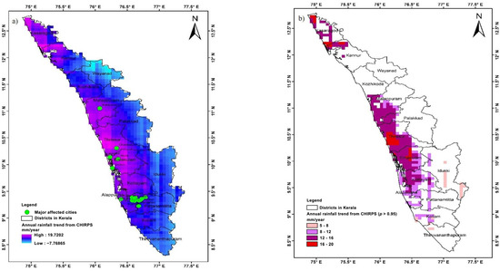
Figure 7.
(a) Pixel-wise trend analysis of annual monsoon rainfall from 1981 to 2018 in Kerala, India. (b) Pixel-wise signification trend analysis (95% confidence level) of annual monsoon rainfall from 1981 to 2018 in Kerala, India [64].
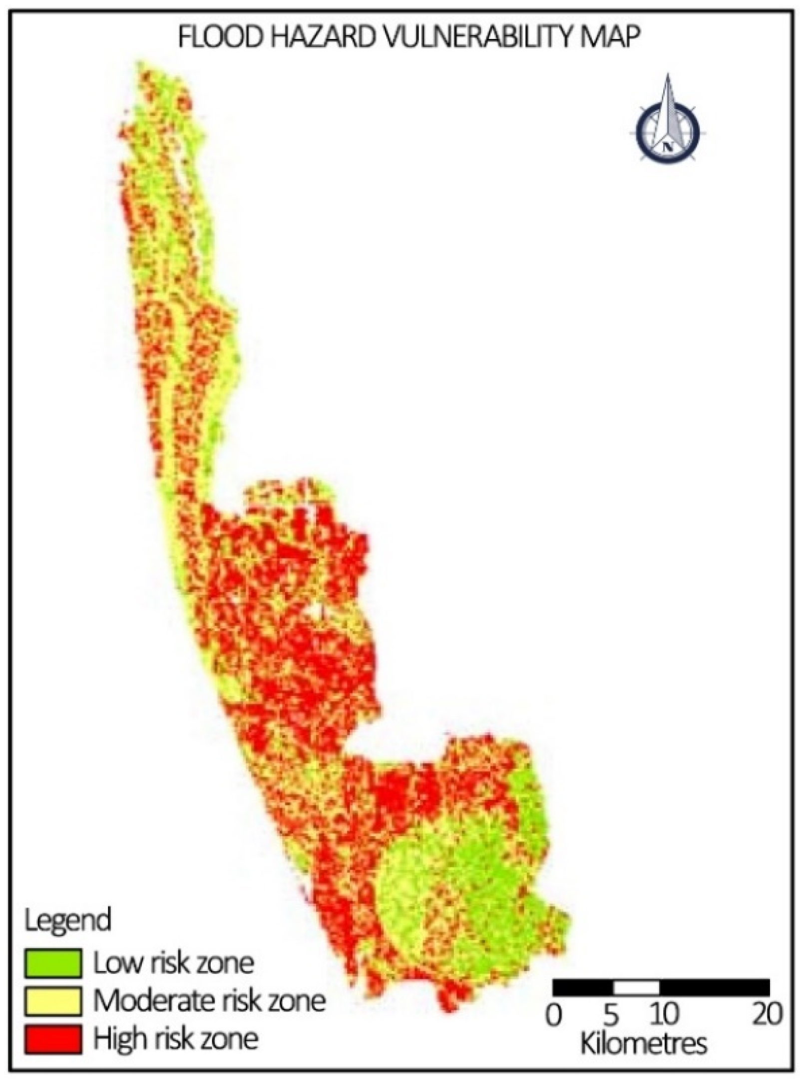
According to government records, Alappuzha is one of India’s most densely populated districts. However, most of the district lies in high-to-moderate flood risk zones, as illustrated in the flood hazard vulnerability map of Alappuzha (Figure 8). Roy et al. [65] created the map using ArcGIS Desktop 10.3 software and remote sensing by weighted overlay of flow accumulation, land use, rainfall, slope, and soil. The technique of this research involves the reclassification of separate maps, followed by overlaying them using a weightage factor to generate a flood hazard vulnerability map. The relatively low elevation of Alappuzha contributes to its heightened susceptibility to floods and coastal erosion during extreme weather events. Consequently, the magnitude of the housing crisis increases proportionately during flood events [66]. Rising sea levels also affect freshwater resources, saltwater intrusion, and coastal ecosystems, exacerbating regional challenges. Extreme weather conditions such as high winds, storm surges, flooding, and landslides cause structural collapse, roof damage, foundation erosion, and inundation of buildings. In addition, transportation networks, including roads and bridges, have experienced structural failures, which restrict mobility and access to essential services. While architects and urban professionals consider numerous factors when creating a built environment [67], flooding underscores the importance of prioritising resilient and sustainable principles when designing spaces. Therefore, a shift to flood-resilient building design is significant for Alappuzha.

Figure 8.
Flood hazard vulnerability map [65].
In regions where natural catastrophes are rare, individuals are often unprepared to withstand intermittent weather. Similarly, built environments are generally not designed to resist floods, storms, or earthquakes, limiting the effectiveness of preventive measures in providing complete protection from such events. However, the increased frequency of these threats necessitates the implementation of measures based on the recent findings. Figure 9a depicts the geolocation of the rescue requests received during the 2018 flood. This map clearly demonstrates the severity of the flooding incidence, suggesting changes in weather patterns. Figure 9b illustrates the flooded buildings caused by torrential rainfall of varying intensity in Alappuzha.
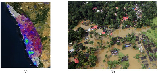
Figure 9.
(a) Map indicating the concentration of rescue requests from regions marked in green during the 2018 flood (parts of Alappuzha) [68]. (b) Aerial view of houses drowned during the flood in Kerala in 2018 [69].
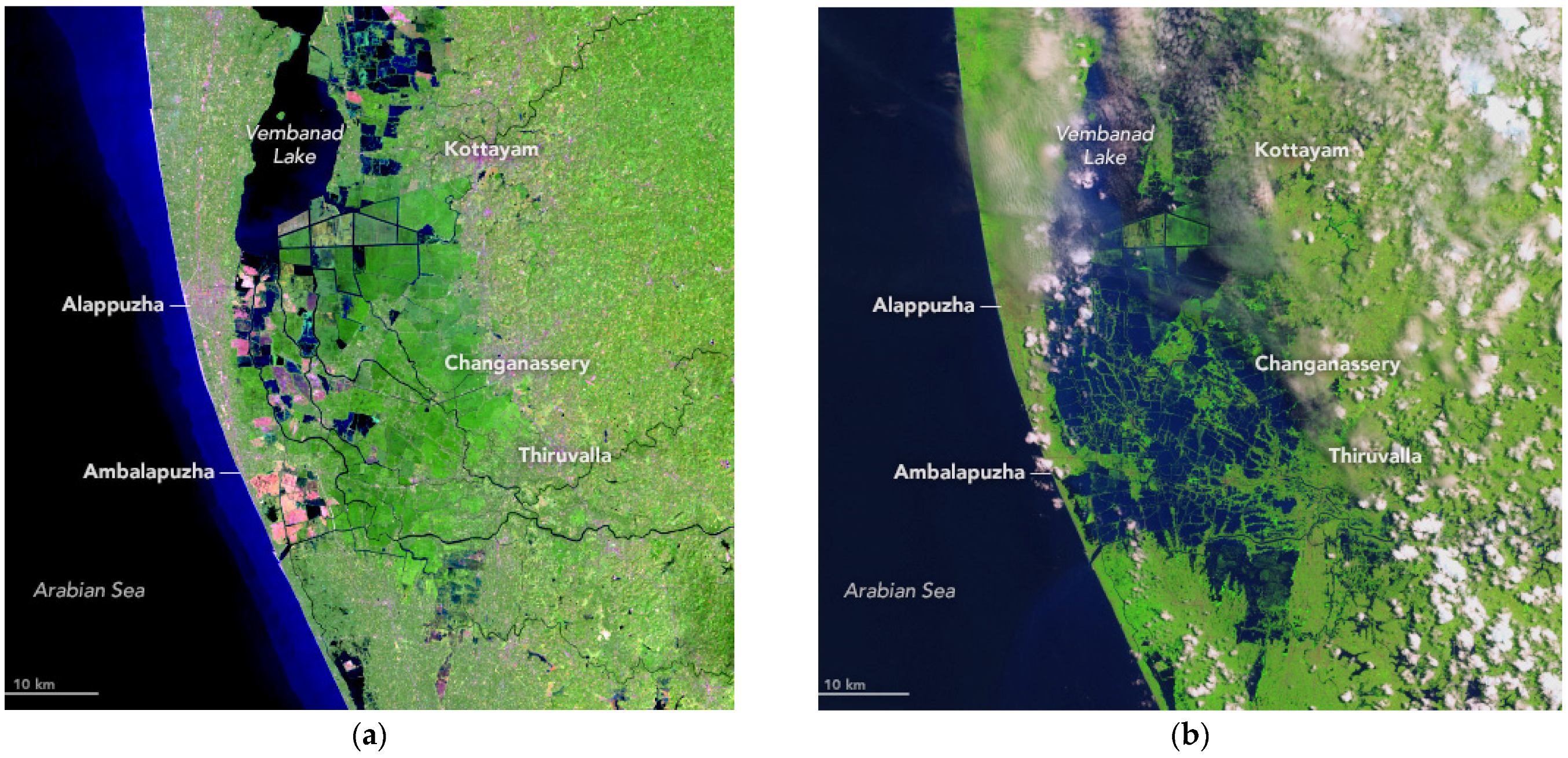
Due to its location and low elevation, Alappuzha is at risk of flooding from rivers and the Arabian Sea (Figure 10a,b). Satellite imagery of Alappuzha town, Vembanad Lake, and its surroundings before and during the cataclysm provides an idea of the extent of the flooding. Because of the area’s low elevation, any standard building was affected by this flood. This inundation pattern is consistent with other Asian cities that have experienced a disproportionately high number of hydrological disasters over the past three decades leading up to 2015 [24]. Therefore, developing an appropriate resilience mechanism is necessary to help the community overcome annual flood challenges. Similarly, it is essential that built environment professionals embrace resilience principles in their design process, especially in flood-prone places such as Alappuzha.

Figure 10.
(a) Vembanad Lake, rivers, canals, and surrounding areas before the 2018 flood. (b) Landsat 8 satellite image during the 2018 flood, depicting the abundance of water in the area [70].
4.2. Traditional Keralan Architecture and Flood Resilience
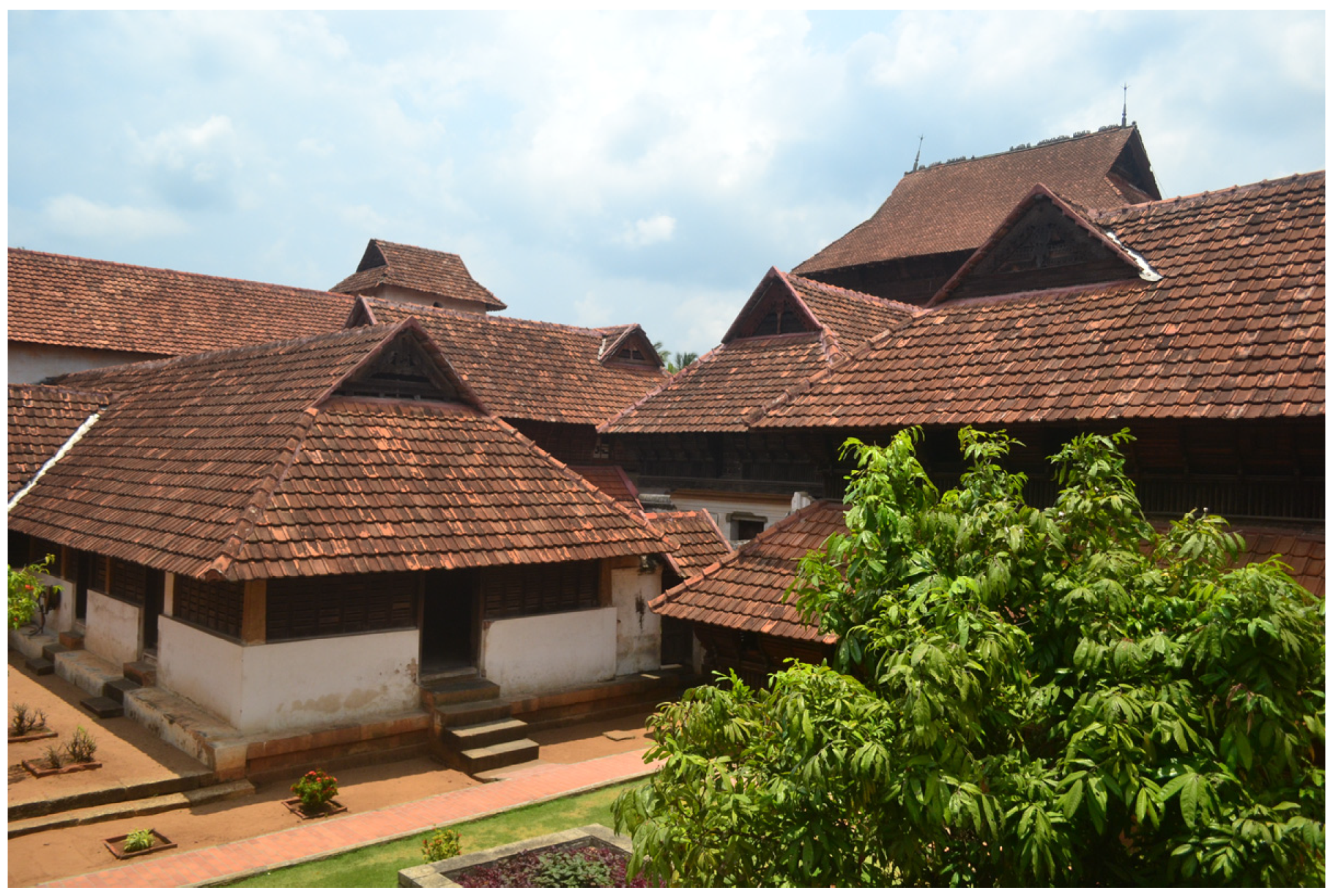
The traditional architecture of Kerala is significantly influenced by its specific climatic conditions, wood abundance, and unique community structure. These factors contribute to the development of distinct features in the architecture and adaptive strategies. The evolution of diverse religious and cultural practices and their prominence during different periods have significantly impacted the shaping of architectural styles. Historically, the forms and features of Keralan architecture have evolved since the Vedic period [71]. Buddhism, Jainism, and Hinduism are believed to have influenced the local architecture during this period. From the 8th to 18th centuries, traditional architecture followed the Vedic science of architecture and became more refined and organised. Wood played a predominant role in the construction materials during these times. During this period, architectural elements and construction techniques were developed in response to the local climate, socioeconomic conditions, cultural heritage, and availability of materials.
During the colonial period from the 16th century to the 20th century, external factors and principles influenced Keralan architecture. The Dutch, French, Portuguese, and English architectural and construction styles were adapted to local practices during the colonial era. Following India’s independence in the mid-20th century, other drastic changes occurred in the social, political, and economic fabric, as well as architectural technology and character. In Kerala, land reform legislation enacted in the 1960s conferred land ownership rights to a large number of tenants who had dwelled under powerful landlords for many generations [72]. From 1960 to 1970, there was a significant migration of people to Middle Eastern countries for employment opportunities. This movement significantly improved the economic status of many families, subsequently referred to as the Gulf Boom [73]. In addition to socioeconomic reforms, the resulting change in the familial structure from large to small nuclear joint families also influenced the emerging architecture. There was also a change in the preference from traditional wooden structures to reinforced concrete buildings (Figure 11).
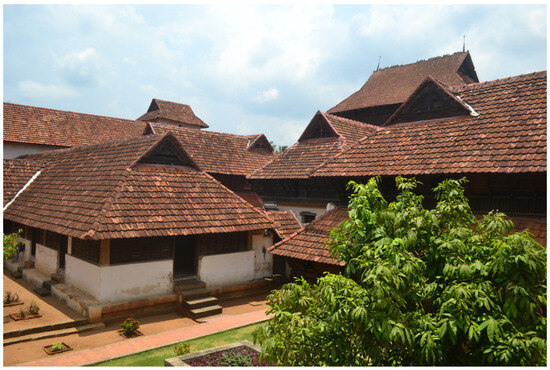
Figure 11.
Gable roofs and wooden ceiling works are the prime features of Kerala’s architectural style.
Contemporary houses in Kerala are predominantly concrete buildings built for and occupied by single families, which has resulted from the change in the familial structure. The choice of building materials has significantly evolved in the last two decades, owing to increased access to resources worldwide after economic liberalisation and globalisation in India [74]. While the construction of single-family homes undoubtedly exacerbates the housing crisis by reducing the available land for housing, the influx of imported building materials presents unprecedented challenges for waste management and contributes to climate change. A sustainable development approach to these issues can be achieved through careful consideration, balancing community and economic development, land-use planning and design, and the appropriate use of technology [75].
4.3. Flood Resilience Approaches in Kerala
Discussions on flood resilience in Kerala are centred on two approaches: employing techniques to avoid flood inundation, or accepting that flooding is an unavoidable reality and modifying life and the physical environment to partially mitigate the impact of floods. While the former tends to be more straightforward to implement, the latter evolves from the complex reality that it is neither economically nor practically feasible to abandon or rebuild many existing houses vulnerable to annual flooding.
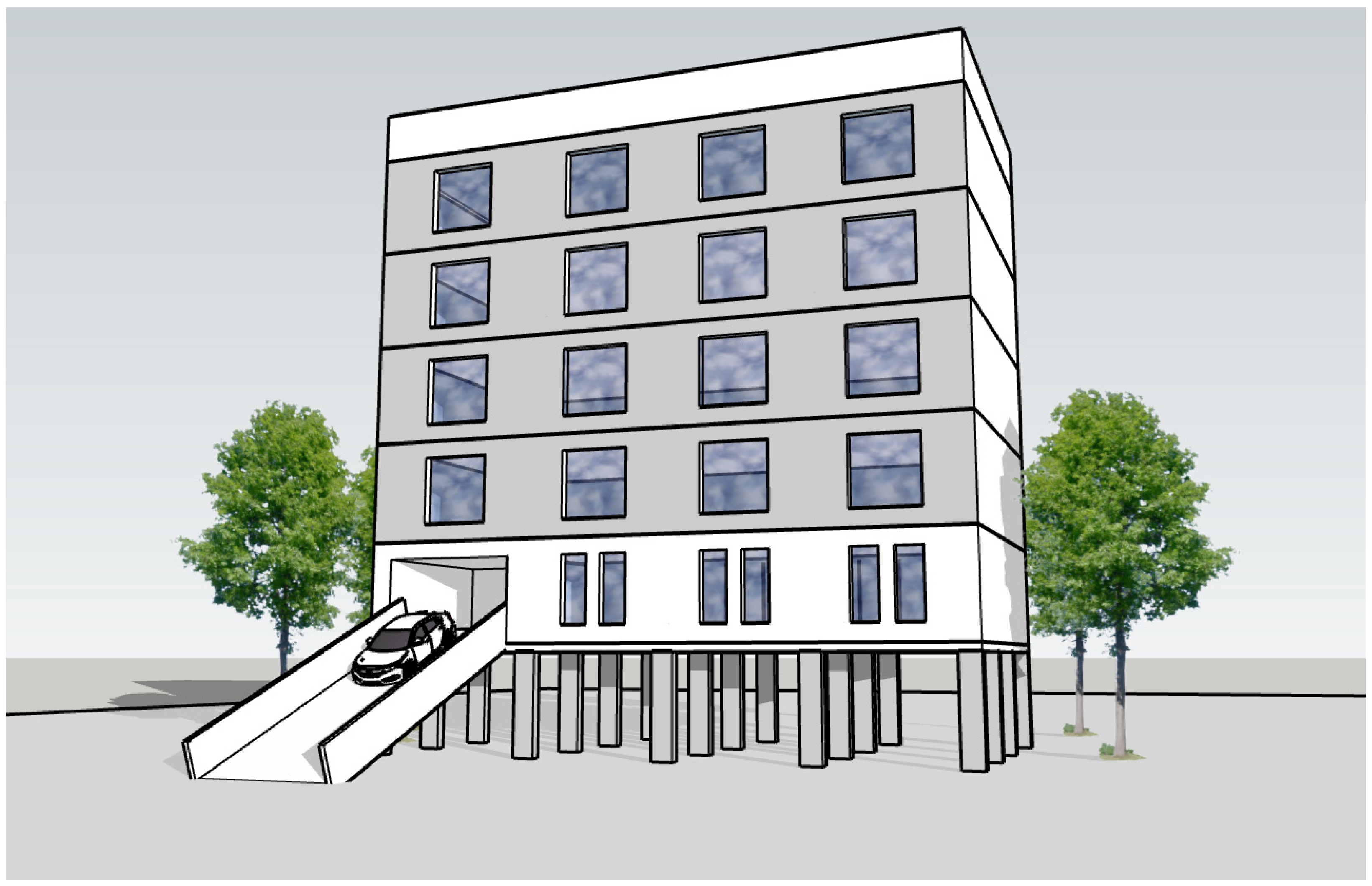
Using the first approach, studies have focused on innovative design concepts that can completely avoid flooding. Singh et al. [76] attempted a flood-resistant design for a six-storey residential building in Malappuram, which is around 200 km away from Alappuzha. Flood resistance was analysed only from a structural design standpoint. The study suggested building elevated liveable spaces above ground level, supported by appropriate concrete columns. A notable departure from the conventional design is the placement of car parking on the first floor rather than at ground level (Figure 12). The study assumed that an adequate height is required for retaining walls to resist future floods of greater magnitude and higher flow. Although such proposals for multistorey buildings can provide practical solutions to protect both residents and their vehicles from flooding, they are ineffective in most existing single-floor houses.
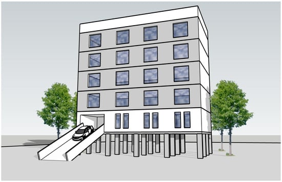
Figure 12.
Model of flood-resilient multistorey building with elevated car parking.
More than 200,000 houses in the Kuttanad region are susceptible to flooding, potentially requiring expensive and comprehensive flood mitigation measures. Despite the prevalence of the first approach worldwide, it is important to note that the number of houses built on stilts may depend on socioeconomic context. Studies have proposed implementing resilient solutions such as incorporating elevated rooms and bathing in standalone single-floor houses [60]. Although this proposal raises the topic of adaptation during annual floods, it is important to question its practicality because of its financial implications for the government, which would potentially be responsible for retrofitting and financing. Nonetheless, the state government encourages individual reconstruction in flood-affected areas, rather than fully funding rebuilding efforts [77]. Other proposals suggest building a multipurpose community centre in every low-lying village to function as a relief camp during floods, instead of using physical measures to enhance the flood resilience of individual housing units [60]. In addition, the study refutes the notion that individuals should live in flood-resistant houses.
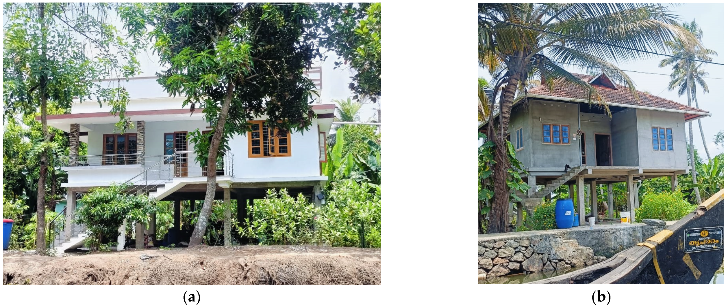
When it comes to building stilts to evade floods, there are differing views, particularly regarding single-family residential units. Despite the assumption that stilted concrete buildings are unaffordable for most people in the region [60], the authors have documented the trends of these structures (Figure 13). Static elevated structures, known as stilt buildings, are designed specifically for flood resilience, without any living space on the ground floor. In contrast to traditional single-storey buildings, which are relatively less costly, these structures possess the notable benefit of resisting inundation during periods of exceptionally high water levels, owing to their elevated clearance from the ground. This approach has become popular with new buildings with the increasing awareness of flood vulnerability. Alternative strategies should focus on retrofitting and revitalising opportunities to enhance the flood resistance of existing single-storey buildings.
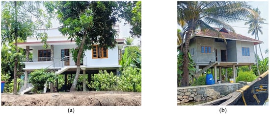
Figure 13.
(a,b) Photographs of elevated houses built on concrete stilts in the Kuttanad region.
Therefore, the socioeconomic and cultural factors in flood-resilient housing cannot be overlooked. In addition to stilt houses, residents are refining the concept of temporarily elevating their buildings by using hydraulic jacks to provide a more flexible gap from the ground level. Typically, structural elevation involves lifting the home off its existing foundation or slab, and then building a new foundation or extending the current one to a higher level. Between 2014 and 2020, reports indicate that more than 50 houses in low-lying areas of Kuttanad were elevated to evade annual floods (Figure 14). The technology of lifting buildings is becoming popular in this area because of its lower cost and shorter completion time compared to the construction of new structures. According to Philip [78], the cost of lifting houses is only one-tenth that of building new buildings, which can be accomplished in a few months. Residents prefer to adopt this flood-evading technique whenever it is feasible and affordable. These examples contradict the “suffer and live with flood” ideology. The live-with-floods approach is beneficial in dealing with the existing housing stock, which cannot be demolished and rebuilt altogether.
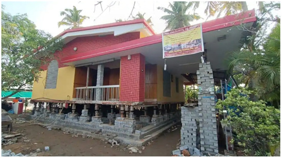
Figure 14.
A house in Kuttanad using hydraulic jacks [79].
Although amphibious houses offer an excellent relationship between land and water, they are not a common typology in this region. The cultural and regulatory issues associated with this type of construction are similar to those associated with floating houses. Scholars argue that introducing floating structures in unfamiliar places can adversely affect genius loci [34]. Although several studies have suggested that amphibious foundations are cost-effective and overcome the limitations of other methods [20], these structures still face reliability issues and are considered to be in the implementation phase [38]. However, amphibious houses have the advantage of resembling traditional brick-and-mortar houses in terms of appearance, while also escaping floods of almost any level.
Floating houses are uncommon in Kerala, unlike in other cities in Thailand, Vietnam, and the Netherlands. This is attributed to several factors, including excessive costs, inadequate safety and security features, and social and cultural challenges associated with owning a house situated in water. Residents indicated that the high cost of building traditional houseboats and the easily flammable construction materials are inhibiting factors. The respondents remarked that individuals with the financial means to purchase property in other locations were relocating from flood-prone regions. Consequently, lower-income individuals mainly remain in such areas, which explains the lack of experimentation with expensive measures. Moreover, regulatory issues also contribute to the slow progress in the adoption of this typology of housing. Local building codes do not specify guidelines for construction in water but mandate a specified distance from water bodies when constructing on plots adjacent to rivers or lakes.
A comparative analysis of the three distinct flood resilience techniques (stilt, floating, and amphibious) highlighted their regional prevalence. Stilted houses are the most common typology among flood-resilient new constructions, and hydraulic jack lifting is the technique used in existing houses. Although stilted houses (static elevation) have relative advantages, socioeconomic and cultural issues have curtailed the pervasive acceptance of permanently elevating houses. As in the case of New Orleans [34], there are three drawbacks:
- Structural and practical limitations: Raising houses (sometimes even up to 12–15 feet) above the street resolves the issue of flooding but makes accessibility to living areas difficult and makes everyday life inconvenient. Elevating buildings in such areas also makes them vulnerable to wind.
- Loss of neighbourhood character: Transformations to permanently elevated houses deprive neighbourhoods of all their historic urban character. Such an approach will also affect how communities and people connect.
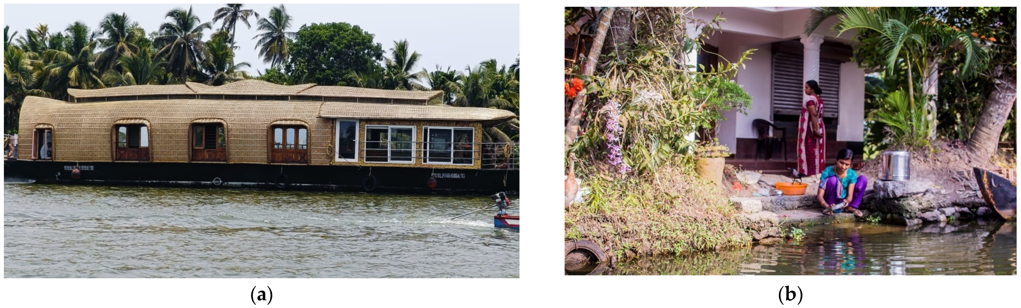
- Increasing the width and stability of stilts can enhance their structural stability, but it also increases construction costs, potentially making them unaffordable for most residents. Most importantly, English [34] pointed out that any fixed elevation will not ensure full floodproofing, which makes the entire effort to elevate unworthy. In the predominantly agrarian communities of Alappuzha, people have strong connections with land and water, as shown in Figure 15. Residents are not confined to the boundaries of their homes but, rather, interact with the immediate outdoor environment for their daily tasks. As a result, permanently elevating houses owing to the risk of floods may not be the optimal decision.
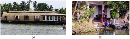 Figure 15. (a) People easily access boats and floating houseboats moored in the water in front of their houses. (b) Individuals depend on the lakes and canals around their houses for cleaning, washing, transportation, and other activities [80].
5. Conclusions
This study explored the flood resilience of the Alappuzha region in India, which has been prone to severe floods in recent years. Using literature analysis, site observations, media insights, and interviews, this study examined flood vulnerability and various resilience methods to determine the approaches, including their advantages and disadvantages. The main goal of this study was to inform policymakers and communities of context-specific flood resilience strategies, acknowledging the sociocultural and environmental nuances of Alappuzha.
The traditional Keralan architecture evolved in response to the region’s geographic context, locally available resources, and climatic conditions. Construction elements such as mud, bricks, and wood were sourced locally from within the environment. Based on this analysis, there has been a shift from locally sourced materials to imported materials for house construction, which does not conform to the resilience or sustainability precepts. Traditional Keralan houses, although not completely flood-resistant, are often located on elevated sites or constructed on higher platforms in flood-prone areas. The increasing population and housing demand exert pressure on the limited amount of elevated land available for residential construction. Rather than traditional large-family houses, the proliferation of single-family houses has diminished the probability of acquiring elevated land for development purposes. This has also strained current wetland ecosystems, which have diminished recently because of construction and other anthropogenic activities. Studies have noted that floodplain wetlands have a more significant potential to reduce floods, while their loss can further amplify the risk [50,51,52]. This situation highlights the need for careful planning and management to ensure the long-term sustainability of these ecosystems.
Furlan et al. [81] noted that urban planners often underestimate the influence of ecological systems and the social basis of well-being when assessing built environments. Drawing on various papers and studies on the subject, this study concludes that Alappuzha is highly vulnerable to the threat of flooding, especially the existing single-family homes in this region. With the current trajectory, researchers anticipate that an increase in sea level will result in ineffective water discharge into the ocean, thereby giving rise to both inland and riverine flooding in the near future. This pattern of hydrological threats is consistent with those of other Asian coastal cities [24].
To prepare for these imminent adverse events, Alappuzha requires a robust, long-term solution that considers two fundamental aspects: First, resilient solutions that anticipate aggressive rain and floods should be developed in the immediate future. Although flood vulnerability modelling in Kerala indicates present and future concerns, there is a need for EWS implementation in Kerala, particularly within the low-lying areas identified as the most vulnerable. The existing EWSs in the study region are local cable television channels, such as KCV, which are effectively used to communicate flood warnings to local communities. Nonetheless, a new EWS for Kuttanad should be created using a community-oriented approach integrated with traditional knowledge [82].
Second, by employing energy-efficient and eco-friendly building techniques and materials, it is possible to minimise the environmental impact of construction projects. This approach involves the use of locally sourced materials and technologies that are sensitive to the local climatic conditions. By doing so, it is possible to reduce the carbon footprint of buildings and contribute to global efforts to mitigate climate change. Coastal areas such as Alappuzha should focus on developing socioeconomic resilience to survive flooding [83]. Unfortunately, individuals with greater financial means relocate to other areas, widening the socioeconomic gap and further exacerbating inequitable access to safety and security. It is essential to take appropriate measures to resolve this problem and to guarantee that all individuals, regardless of their economic situation, have access to safe and secure living circumstances.
The concept of resilience observed in the case of Alappuzha is oriented towards the engineering resilience approach, whereas ecological resilience has not been explored. Stilted houses, which are the most common typology observed in the examples within and outside Alappuzha, are a product of the engineering resilience approach that attempts to evade floods by raising the threshold of resistance and expecting to return to the original state. Several studies have described a similar preference for the engineering resilience approach as an immediate solution to flooding [33]. The ecological resilience approach should yield a different product by permanently bouncing forward toward a state of higher resilience.
There is an awareness of the need for flood-resilient construction practices, as observed in this study, especially in popular media, articles, newspapers, and social media. The increased frequency of flood occurrences demands alternatives to traditional construction. However, a resilient solution that is structurally, economically, and culturally acceptable is not yet available. Potential resilience approaches include stilt houses, amphibious foundations, and floating structures, each with its own merits and demerits. Among the flood-resistant housing types in the research area, stilt buildings are the most prevalent for new construction, whereas hydraulic jack lifting is the most common approach for existing houses. Nonetheless, structural limits and the loss of neighbourhood characteristics are critical challenges of elevating houses on stilts, which limit holistic resilience. In addition, buildings with stilted foundations are disconnected from ground activities, leading to an imbalance in their fundamental connections with the outdoor environment.
Although Alappuzha is renowned for its construction of traditional houseboats, experimental floating and amphibious houses are not commonly observed in this area. The risks associated with wooden boat construction, in terms of fires, are prevalent in this region. Floating houses lack structural stability compared with traditional brick-and-mortar houses. Moreover, higher construction and maintenance costs present significant barriers to the adoption of floating houses. Cultural factors also play a significant role in limiting the popularity of these types of dwellings. However, amphibious houses are a promising concept whose safety limits depend only on the guiding piles. While buoyancy and weight-balancing issues have been noted in many experimental setups, amphibious houses could be a potential permanent solution for Alappuzha. Onsite experiments are required to further explore these challenges and solutions. Developing indigenous solutions inspired by locally available materials and techniques can increase the likelihood of resilience.
Developing resilience requires addressing fundamental questions based on our understanding of the built environment. When discussing engineering resilience, which aims to “bounce back quickly” to its previous state (the preferred state of equilibrium), we must question the need to return to a condition that has previously been shown to lack resilience. Therefore, bouncing back may not be the most suitable option to protect houses against floods. Concepts such as “Build Back Better” focus on increasing the tolerance threshold rather than reverting to the previous state. These are more aligned with the idea of ecological resilience and are appropriate for this scenario.
This research has universal significance and offers practical solutions for other cities, especially in developing countries with similar socioeconomic and environmental contexts. Although this case study concentrates specifically on the Alappuzha area, the findings could be more broadly applicable for pre-flooding resilience and post-disaster recovery, especially in low-lying regions where frequent floods occur. This study contributes to the theoretical understanding of community-based resilience in flood-prone areas. While several studies have concentrated on the instances of New Orleans, the Netherlands, and other developed locations, this study supplements the growing collection of literature that focuses on emerging nations. The solutions and lessons from the Alappuzha case study could substantially contribute to creating more resilient communities. In addition, the focus on low-cost approaches and sustainable land-use practices can be adopted as best practices in flood risk management.
While the strategies for responding to floods differ across regions, the underlying reasons for such adaptation have remained consistent. Ensuring safety requires a combination of traditional practices and modern solutions to address the threats posed by the constantly changing environment. Through an analysis of local adaptation mechanisms, this case study contributes to the international discourse on climate adaptation and disaster management. The results can significantly impact global policymaking, facilitate collaboration across borders, and drive the adaptation of AI technology to different city forms. They can also be applied to academic curricula and training forums worldwide, creating a universal discourse on sustainable urbanism.
6. Limitations
Flood resilience is a vast topic that can be studied from various perspectives. Engineering, sociology, medicine, and economics are some of the few broader titles under which it is usually studied. Flood resilience cannot be achieved without simultaneously considering some or most related topics. While it is necessary for scientific studies to focus on specific aspects, this research only provides an overview of the socioeconomic and cultural factors associated with the study area. An in-depth analysis of these factors was not provided, so as to limit the scope. Similarly, while there are several types of flood-resilient building practices around the world, we have considered only three specific types of flood-resilient building practices that are the most relatable to the context of the study area.
7. Contribution to Knowledge
This study investigated flood resilience in Alappuzha, Kerala—a region that faces heightened flood risks. This study contributes to the existing body of knowledge by (1) exploring the impact on housing and proposing flood resilience technologies for Alappuzha; (2) tracing the evolution of Kerala’s architecture from traditional wooden structures to contemporary concrete buildings, emphasising the shift’s implications for flood vulnerability; (3) incorporating global insights into flood-resilient techniques, considering stilt houses, amphibious foundations, and floating structures; and (4) analysing literature, media, and local interviews.
In response to the unique flood challenges faced by Alappuzha, it is imperative to guide policymakers in crafting tailored flood resilience strategies that consider the region’s sociocultural fabric and environmental dynamics. By recognising these nuances, policymakers can ensure that resilience measures are effective and sensitive to the needs and practices of the local population. Additionally, there is a pressing need to foster experimentation using various flood resilience methods to mitigate the potential hazards posed by flooding. Through rigorous study and analysis of different approaches, including their strengths, limitations, and feasibility, a deeper understanding can be gained, allowing for informed decision-making and implementation. Community engagement and participation play pivotal roles in developing robust flood resilience strategies. By involving residents in the process and soliciting their feedback, it is possible to harness local knowledge and insights, thereby enhancing the relevance and effectiveness of resilience. This collaborative approach ensures that resilience measures are not only inclusive, but also reflective of diverse perspectives and priorities within the community.
Future research should thoroughly examine and compare the technical specifications of both local and national building laws and regulations designed to mitigate or restrict the adverse impacts of flooding incidents. Furthermore, it is important for studies to consider regional, national, and international practices of other nations that have comparable flooding situations.
Author Contributions
Conceptualisation, A.A.C. and M.G.M.; methodology, A.A.C. and M.G.M.; software, A.A.C. and H.A.A.M.; validation, A.A.-K., G.B. and R.F.; formal analysis, H.A.A.M. and G.B.; investigation, A.A.C., M.G.M. and H.A.A.M.; resources, A.A.-K. and H.A.A.M.; data curation, G.B. and R.F.; writing—original draft preparation, A.A.C. and M.G.M.; writing—review and editing, A.A.-K., G.B., H.A.A.M. and R.F.; visualisation, A.A.C. and M.G.M.; supervision, A.A.-K., G.B. and R.F.; project administration, R.F.; funding acquisition, A.A.-K., H.A.A.M. and R.F. All authors have read and agreed to the published version of the manuscript.
Funding
This research was funded by Qatar University’s Student Grant 2025 Cycle #1, January 2025–May 2025. The authors would like to acknowledge DAUP and Qatar University for its research-oriented vision and its support for sustainable development.
Institutional Review Board Statement
The authors declare that no ethical review and approval were required for this study.
Informed Consent Statement
Written informed consent for participation was not required because all participants’ data was anonymized before analyses were done.
Data Availability Statement
The data used in this research have been presented in the article.
Conflicts of Interest
The authors declare no conflicts of interest.
References
- Bektaş, Y.; Sakarya, A. The Relationship between the Built Environment and Climate Change: The Case of Turkish Provinces. Sustainability 2023, 15, 1659. [Google Scholar] [CrossRef]
- World Bank. Kerala Partnership Breaks New Ground in Mainstreaming Adaptation to Climate Change. Available online: https://www.worldbank.org/en/country/india/brief/world-bank-kerala-state-partnership-breaks-new-ground-in-sub-national-strategic-engagement (accessed on 22 January 2024).
- Chao-Amonphat, S.; Nitivattananon, V.; Srinonil, S. Adaptation Measures on Hydrological Risks and Climate Change Impacts in Urbanized Sub-Region, Thailand: A Case Study in Lower Chao Phraya River Basin. Int. J. Disaster Resil. Built Environ. 2024, 15, 59–79. [Google Scholar] [CrossRef]
- Ariyaningsih; Sukhwani, V.; Shaw, R. Vulnerability Assessment of Balikpapan (Indonesia) for Climate Change-Induced Urban Flooding. Int. J. Disaster Resil. Built Environ. 2023, 14, 387–401. [Google Scholar] [CrossRef]
- Tahir, F.; Madandola, M.G.; Al-Ghamdi, S.G. Enhancing Resilience: Surveillance Strategies for Monitoring the Spread of Vector-Borne Diseases. In Sustainable Cities in a Changing Climate; John and Wiley and Sons: Hoboken, NJ, USA, 2024; pp. 263–276. [Google Scholar]
- Sharifi, A. Flood Mapping Using Relevance Vector Machine and SAR Data: A Case Study from Aqqala, Iran. J. Indian Soc. Remote Sens. 2020, 48, 1289–1296. [Google Scholar] [CrossRef]
- Fahad, S.; Hossain, M.S.; Huong, N.T.L.; Nassani, A.A.; Haffar, M.; Naeem, M.R. An Assessment of Rural Household Vulnerability and Resilience in Natural Hazards: Evidence from Flood Prone Areas. Environ. Dev. Sustain. 2023, 25, 5561–5577. [Google Scholar] [CrossRef]
- Sarıcıoğlu, P.; Ayçam, İ. Building Design in the Context of Climate Change and a Flood Projection for Ankara. In Adapting the Built Environment for Climate Change; Elsevier: Amsterdam, The Netherlands, 2023; pp. 327–347. [Google Scholar]
- Chmutina, K.; Lizarralde, G.; von Meding, J.; Bosher, L. Standardised Indicators for “Resilient Cities”: The Folly of Devising a Technical Solution to a Political Problem. Int. J. Disaster Resil. Built Environ. 2023, 14, 514–535. [Google Scholar] [CrossRef]
- Adegun, O.B. Flood-Related Challenges and Impacts within Coastal Informal Settlements: A Case from LAGOS, NIGERIA. Int. J. Urban Sustain. Dev. 2023, 15, 1–13. [Google Scholar] [CrossRef]
- Islam, A.; Shit, P.K.; Datta, D.K.; Islam, M.S.; Roy, S.; Ghosh, S.; Das, B.C. Floods in the Ganga–Brahmaputra–Meghna Delta; Springer International Publishing: Cham, Switzerland, 2023; ISBN 978-3-031-21085-3. [Google Scholar]
- Bernardini, G.; Ferreira, T.M.; Baquedano Julià, P.; Ramírez Eudave, R.; Quagliarini, E. Assessing the Spatiotemporal Impact of Users’ Exposure and Vulnerability to Flood Risk in Urban Built Environments. Sustain. Cities Soc. 2024, 100, 105043. [Google Scholar] [CrossRef]
- Felsenstein, D.; Lichter, M. Social and Economic Vulnerability of Coastal Communities to Sea-Level Rise and Extreme Flooding. Nat. Hazards 2014, 71, 463–491. [Google Scholar] [CrossRef]
- Bukvic, A.; Barnett, S. Drivers of Flood-Induced Relocation among Coastal Urban Residents: Insight from the US East Coast. J. Environ. Manag. 2023, 325, 116429. [Google Scholar] [CrossRef]
- Kuru, O.D.; Ganapati, N.E.; Marr, M. Perceptions of Local Leaders Regarding Postdisaster Relocation of Residents in the Face of Rising Seas. Hous. Policy Debate 2023, 33, 1124–1145. [Google Scholar] [CrossRef]
- Krishnakumar, K.N.; Prasada Rao, G.S.L.H.V.; Gopakumar, C.S. Rainfall Trends in Twentieth Century over Kerala, India. Atmos. Environ. 2009, 43, 1940–1944. [Google Scholar] [CrossRef]
- Vijaykumar, P.; Abhilash, S.; Sreenath, A.V.; Athira, U.N.; Mohanakumar, K.; Mapes, B.E.; Chakrapani, B.; Sahai, A.K.; Niyas, T.N.; Sreejith, O.P. Kerala Floods in Consecutive Years—Its Association with Mesoscale Cloudburst and Structural Changes in Monsoon Clouds over the West Coast of India. Weather Clim. Extrem. 2021, 33, 100339. [Google Scholar] [CrossRef]
- Chithra, K.; Binoy, B.V.; Bimal, P. Spatial Mapping of the Flood-Affected Regions of Northern Kerala: A Case Study of 2018 Kerala Floods. J. Indian Soc. Remote Sens. 2022, 50, 677–688. [Google Scholar] [CrossRef]
- Archer, R.; Choi, H.; Vasconez, R.; Najm, H.; Gong, J. Adaptive Coastal Construction: Designing Amphibious Homes to Resist Hurricane Winds and Storm Surges. J. Ocean Eng. Mar. Energy 2023, 9, 273–290. [Google Scholar] [CrossRef]
- English, E.C.; Chen, M.; Zarins, R.; Patange, P.; Wiser, J.C. Building Resilience through Flood Risk Reduction: The Benefits of Amphibious Foundation Retrofits to Heritage Structures. Int. J. Archit. Herit. 2021, 15, 976–984. [Google Scholar] [CrossRef]
- Ameh, H.; Badarnah, L.; Lamond, J. Amphibious Architecture: A Biomimetic Design Approach to Flood Resilience. Sustainability 2024, 16, 1069. [Google Scholar] [CrossRef]
- Marlow, E.C.; Chmutina, K.; Dainty, A. Interpreting Sustainability and Resilience in the Built Environment. Int. J. Disaster Resil. Built Environ. 2023, 14, 332–348. [Google Scholar] [CrossRef]
- Wisner, B. Five Years Beyond Sendai—Can We Get Beyond Frameworks? Int. J. Disaster Risk Sci. 2020, 11, 239–249. [Google Scholar] [CrossRef]
- UNISDR. How To Make Cities More Resilient A Handbook For Local Government Leaders A Contribution to the Global Campaign 2010–2020 Making Cities Resilient—“My City Is Getting Ready!”; UNISDR: Geneva, Switzerland, 2017. [Google Scholar]
- The Rockefeller Foundation and Arup. City Resilience Framework; The Rockefeller Foundation and Arup: London, UK, 2015. [Google Scholar]
- Holling, C.S. Resilience and Stability of Ecological Systems. Annu. Rev. Ecol. Syst. 1973, 4, 1–23. [Google Scholar] [CrossRef]
- Meerow, S.; Newell, J.P. Urban Resilience for Whom, What, When, Where, and Why? In Geographic Perspectives on Urban Sustainability; Routledge: London, UK, 2021; pp. 43–63. [Google Scholar]
- Amirzadeh, M.; Sobhaninia, S.; Sharifi, A. Urban Resilience: A Vague or an Evolutionary Concept? Sustain. Cities Soc. 2022, 81, 103853. [Google Scholar] [CrossRef]
- Bush, J.; Doyon, A. Building Urban Resilience with Nature-Based Solutions: How Can Urban Planning Contribute? Cities 2019, 95, 102483. [Google Scholar] [CrossRef]
- Davoudi, S. Resilience: A Bridging Concept or a Dead End? Plan. Theory Pract. 2012, 13, 299–333. [Google Scholar] [CrossRef]
- Major, M.D.; Al-Nabet, S.F. Building’s Don’t Bounce: The Design Paradox of Urban Resilience. In Proceedings of the 26th Annual Congress for The New Urbanism, Savannah, GA, USA, 16 May 2018; pp. 1–10. [Google Scholar]
- UNDRR. Global Assessment Report on Disaster Risk Reduction 2019; UNISDR: Geneva, Switzerland, 2019; ISBN 9789210041805. [Google Scholar]
- Matczak, P.; Hegger, D. Improving Flood Resilience through Governance Strategies: Gauging the State of the Art. WIREs Water 2021, 8, e1532. [Google Scholar] [CrossRef]
- English, E.C. Amphibious Foundations and the Buoyant Foundation Project: Innovative Strategies for Flood Resilient Housing. In Proceedings of the International Conference on Urban Flood Management, Paris, France, 25–27 November 2009; pp. 1–8. [Google Scholar]
- Topsider Hurricane Homes. Available online: https://www.topsiderhomes.com/hurricane-proof-homes.php (accessed on 3 March 2024).
- Prosun, P. LIFT House: An Amphibious Strategy for Sustainable and Affordable Housing for the Urban Poor in Flood-Prone Bangladesh. Ph.D. Thesis, University of Waterloo, Waterloo, ON, Canada, 2011. [Google Scholar]
- Moon, C. A Study on the Floating House for New Resilient Living. J. Korean Hous. Assoc. 2015, 26, 97–104. [Google Scholar] [CrossRef]
- Piatek, Ł.; Wojnowska-Heciak, M. Multicase Study Comparison of Different Types of Flood-Resilient Buildings (Elevated, Amphibious, and Floating) at the Vistula River in Warsaw, Poland. Sustainability 2020, 12, 9725. [Google Scholar] [CrossRef]
- Brody, S.D.; Zahran, S.; Maghelal, P.; Grover, H.; Highfield, W.E. The Rising Costs of Floods: Examining the Impact of Planning and Development Decisions on Property Damage in Florida. J. Am. Plan. Assoc. 2007, 73, 330–345. [Google Scholar] [CrossRef]
- Bin, L.; Xu, K.; Pan, H.; Zhuang, Y.; Shen, R. Urban Flood Risk Assessment Characterizing the Relationship among Hazard, Exposure, and Vulnerability. Environ. Sci. Pollut. Res. 2023, 30, 86463–86477. [Google Scholar] [CrossRef] [PubMed]
- Zhao, H.; Gu, T.; Tang, J.; Gong, Z.; Zhao, P. Urban Flood Risk Differentiation under Land Use Scenario Simulation. iScience 2023, 26, 106479. [Google Scholar] [CrossRef]
- Idowu, D.; Zhou, W. Global Megacities and Frequent Floods: Correlation between Urban Expansion Patterns and Urban Flood Hazards. Sustainability 2023, 15, 2514. [Google Scholar] [CrossRef]
- Seemuangngam, A.; Lin, H.-L. The Impact of Urbanization on Urban Flood Risk of Nakhon Ratchasima, Thailand. Appl. Geogr. 2024, 162, 103152. [Google Scholar] [CrossRef]
- Yang, Q.; Zhang, S.; Dai, Q.; Yao, R. Assessment of Community Vulnerability to Different Types of Urban Floods: A Case for Lishui City, China. Sustainability 2020, 12, 7865. [Google Scholar] [CrossRef]
- Tempa, K. District Flood Vulnerability Assessment Using Analytic Hierarchy Process (AHP) with Historical Flood Events in Bhutan. PLoS ONE 2022, 17, e0270467. [Google Scholar] [CrossRef] [PubMed]
- Manandhar, B.; Cui, S.; Wang, L.; Shrestha, S. Urban Flood Hazard Assessment and Management Practices in South Asia: A Review. Land 2023, 12, 627. [Google Scholar] [CrossRef]
- Zhou, Y.; She, D.; Wang, Y.; Xia, J.; Zhang, Y. Evaluating the Impact of Low Impact Development Practices on the Urban Flooding over a Humid Region of China. JAWRA J. Am. Water Resour. Assoc. 2022, 58, 1264–1278. [Google Scholar] [CrossRef]
- Huang, Y.; Lin, J.; He, X.; Lin, Z.; Wu, Z.; Zhang, X. Assessing the Scale Effect of Urban Vertical Patterns on Urban Waterlogging: An Empirical Study in Shenzhen. Environ. Impact Assess. Rev. 2024, 106, 107486. [Google Scholar] [CrossRef]
- Zhang, D.; Shi, X.; Xu, H.; Jing, Q.; Pan, X.; Liu, T.; Wang, H.; Hou, H. A GIS-Based Spatial Multi-Index Model for Flood Risk Assessment in the Yangtze River Basin, China. Environ. Impact Assess. Rev. 2020, 83, 106397. [Google Scholar] [CrossRef]
- Van Coppenolle, R.; Temmerman, S. Identifying Global Hotspots Where Coastal Wetland Conservation Can Contribute to Nature-Based Mitigation of Coastal Flood Risks. Glob. Planet. Chang. 2020, 187, 103125. [Google Scholar] [CrossRef]
- Berde, V.B.; Chari, P.V.B.; Berde, C.V. Wetland and Biodiversity Hotspot Conservation. In Research Anthology on Ecosystem Conservation and Preserving Biodiversity; IGI Global: Hershey, PA, USA, 2022; pp. 775–784. [Google Scholar]
- Acreman, M.; Holden, J. How Wetlands Affect Floods. Wetlands 2013, 33, 773–786. [Google Scholar] [CrossRef]
- Ming, J.; Xian-guo, L.; Lin-shu, X.; Li-juan, C.; Shouzheng, T. Flood Mitigation Benefit of Wetland Soil—A Case Study in Momoge National Nature Reserve in China. Ecol. Econ. 2007, 61, 217–223. [Google Scholar] [CrossRef]
- Ramachandra, T.V.; Karthick, B.; Boominathan, M.; Ali, A.; Avinash, K.G. Waterscape of Kerala—Characterisation of Surface, Well and Tap Water in All Districts; CES Technical Report 133; Indian Institute of Science: Bangalore, India, 2013. [Google Scholar]
- Indian Ministry of Housing and Urban Affairs. Urbanization in Indian States. Available online: https://mohua.gov.in/cms/level-of-urbanisation.php (accessed on 1 June 2023).
- Government of India. Census of India. Available online: https://censusindia.gov.in/census.website/data/population-finder (accessed on 24 February 2023).
- Kerala State Planning Board. Kerala Development Report: Initiatives, Achievements, and Challenges; Kerala State Planning Board: Thiruvananthapuram, Kerala, 2021.
- The Irrigation Design and Research Board (IDRB) Irrigation Department, Government of Kerala. Available online: https://irrigation.kerala.gov.in/river-basin (accessed on 4 March 2024).
- Department Of Town And Country Planning—Government Of Kerala. District Urbanization Report—Alappuzha; Department Of Town And Country Planning—Government Of Kerala: Kannur, India, 2011.
- Jose, A.V. Building a New Kerala: Ideas and Reflections RULSG-Policy Pointers Series: 9 Some Priorities for Rehabilitation in the Kuttanad Region; Centre for Development Studies (JNU): Thiruvananthapuram, India, 2018. [Google Scholar]
- Jacinth Jennifer, J.; Saravanan, S.; Abijith, D. Integration of SAR and Multi-Spectral Imagery in Flood Inundation Mapping–a Case Study on Kerala Floods 2018. ISH J. Hydraul. Eng. 2020, 28, 480–490. [Google Scholar] [CrossRef]
- Walia, A.; Sharma, P.; Nusrat, N. Kerala Floods 2018: Impacts and Lessons Drawn. In International Handbook of Disaster Research; Springer: Berlin/Heidelberg, Germany, 2022; pp. 1–17. [Google Scholar]
- Balbi, S.; Villa, F.; Mojtahed, V.; Hegetschweiler, K.T.; Giupponi, C. A Spatial Bayesian Network Model to Assess the Benefits of Early Warning for Urban Flood Risk to People. Nat. Hazards Earth Syst. Sci. 2016, 16, 1323–1337. [Google Scholar] [CrossRef]
- Tiwari, V.; Kumar, V.; Matin, M.A.; Thapa, A.; Ellenburg, W.L.; Gupta, N.; Thapa, S. Flood Inundation Mapping-Kerala 2018; Harnessing the Power of SAR, Automatic Threshold Detection Method and Google Earth Engine. PLoS ONE 2020, 15, e0237324. [Google Scholar] [CrossRef] [PubMed]
- Roy, C.M.; Manoj, E.; Joy, H.; Ravi, S.; Roy, A. Development of Flood Hazard Vulnerability Map for Alappuzha District. Int. J. Curr. Eng. Sci. Res. 2018, 5, 77–81. [Google Scholar]
- Government of Kerala. Demography (As Per Provisional Population Figures of 2011 Census). Available online: https://alappuzha.nic.in/en/demography/ (accessed on 17 April 2023).
- Valdeolmillos, N.A.A.; Furlan, R.; Tadi, M.; Sinclair, B.R.; Awwaad, R. Towards a Knowledge-Hub Destination: Analysis and Recommendation for Implementing TOD for Qatar National Library Metro Station. Environ. Dev. Sustain. 2023, 26, 9783–9815. [Google Scholar] [CrossRef]
- Jacob Jikku Varghese Satellite Images, App to Aid Estimate of Kerala Flood Loss. Available online: https://www.onmanorama.com/news/kerala/2018/08/28/satellite-images-app-aid-estimate-kerala-flood-loss.html (accessed on 2 January 2024).
- Venkitasubramanian, S. Floods in Kerala. Available online: https://www.reuters.com/news/picture/floods-in-kerala-idINRTS1XFOF/ (accessed on 7 September 2023).
- Dauphin, L. Before and After the Kerala Floods. Available online: https://earthobservatory.nasa.gov/images/92669/before-and-after-the-kerala-floods (accessed on 4 March 2024).
- Koduveliparambil, J.J. Construction Practices in Traditional Dwellings of Kerala, India. Master’s Thesis, McGill University, Montreal, QC, Canada, 1997. [Google Scholar]
- Kuriakose, B. Evolution of Kerala Architecture Over the Years. Available online: https://www.bennykuriakose.com/post/evolution-of-kerala-architecture-over-the-years (accessed on 31 May 2023).
- Prakash, B.A. Gulf Migration and Its Economic Impact: The Kerala Experience. Econ. Polit. Wkly. 1998, 33, 3209–3213. [Google Scholar]
- Mukherji, R. Introduction: Globalization and Change in India. India Rev. 2019, 18, 1–7. [Google Scholar] [CrossRef]
- Al-Mohannadi, M.; Awwaad, R.; Furlan, R.; Grosvald, M.; Al-Matwi, R.; Isaifan, R.J. Sustainable Status Assessment of the Transit-Oriented Development in Doha’s Education City. Sustainability 2023, 15, 1913. [Google Scholar] [CrossRef]
- Singh, A.K.; Sharma, P.; Krishnaraj, L.; Prasath Kumar, V.R. Design and Analysis of Flood Resisting Residential Building: A Case Study in Malappuram-KERALA. J. Eng. Res. 2022, 9, 1–12. [Google Scholar] [CrossRef]
- Neeraj, S.; Mannakkara, S.; Wilkinson, S. Build Back Better Concepts for Resilient Recovery: A Case Study of India’s 2018 Flood Recovery. Int. J. Disaster Resil. Built Environ. 2020, 12, 280–294. [Google Scholar] [CrossRef]
- Philip, S. Kerala: 2018 Flood on Mind, Houses in Backwaters Region Now on Stilts. Available online: https://indianexpress.com/article/india/kerala-2018-flood-on-mind-houses-in-backwaters-region-now-on-stilts-6484055/ (accessed on 14 April 2023).
- Kerala House Lifting Services. Available online: https://keralahouselifting.com/ (accessed on 29 February 2024).
- Footloose Dev. Life in the Backwaters of Alleppey, Kerala. Available online: https://footloosedev.com/life-in-the-backwaters-of-alleppey-kerala/ (accessed on 1 March 2023).
- Furlan, R.; Grosvald, M.; Azad, A. A Social-Ecological Perspective for Emerging Cities: The Case of Corniche Promenade, “Urban Majlis” of Doha. J. Infrastruct. Policy Dev. 2022, 6, 1496. [Google Scholar] [CrossRef]
- Pramanik, A.; Sujay, P.; Alex, A.M. Capacity Building for Early Warning System (Kavalam Panchayat, Kuttanad Taluk, Alappuzha District, Kerala); Tata Insititute of Social Sciences: Mumbai, India, 2019. [Google Scholar]
- Dutta, M. Disaster Risk Reduction and Resilience Building Among the Coastal Zone Communities in Lakshwadeep and Kerala. In Disaster Risk Reduction: Community Resilience and Responses; Bupinder, Z., Ahmad, A., Srungarapati, A.B., Eds.; Springer Nature: Singapore, 2019; pp. 279–297. ISBN 978-981-10-8845-2. [Google Scholar]


Disclaimer/Publisher’s Note: The statements, opinions and data contained in all publications are solely those of the individual author(s) and contributor(s) and not of MDPI and/or the editor(s). MDPI and/or the editor(s) disclaim responsibility for any injury to people or property resulting from any ideas, methods, instructions or products referred to in the content. |
© 2024 by the authors. Licensee MDPI, Basel, Switzerland. This article is an open access article distributed under the terms and conditions of the Creative Commons Attribution (CC BY) license (https://creativecommons.org/licenses/by/4.0/).