Article

Update of the Interpretive Conceptual Model of Ladeira de Envendos Hyposaline Hydromineral System (Central Portugal): A Contribution to Its Sustainable Use

by
José M. Marques
1,*,
Paula M. Carreira
2,
Pedro Caçador
1 and
Manuel Antunes da Silva
3
1
Instituto Superior Técnico, CERENA, Av. Rovisco Pais, 1049-001 Lisboa, Portugal
2
Instituto Superior Técnico, C2TN, Campus Tecnológico e Nuclear, Estrada Nacional 10 (at km 139.7), 2695-066 Bobadela LRS, Portugal
3
Super Bock Group, Apartado 1044, 4466-955 S. Mamede de Infesta, Portugal
*
Author to whom correspondence should be addressed.
Sustainability 2024, 16(12), 5179; https://doi.org/10.3390/su16125179
Submission received: 8 February 2024 / Revised: 11 June 2024 / Accepted: 12 June 2024 / Published: 18 June 2024
(This article belongs to the Special Issue Sustainable Development of Hydrogeology)

Abstract

:
The aim of this paper is to describe the surveys performed in order to update the interpretive conceptual circulation model of the Ladeira de Envendos hyposaline hydromineral system (Central Portugal). The geology of the Ladeira de Envendos region is strongly controlled by the Amêndoa-Carvoeiro synform, of Ordovician-Silurian age, presenting continuous and aligned quartzite ridges on the NE flank, that form the basic structure of a set of inselbergs. The physico-chemical analysis of the Ladeira de Envendos natural mineral spring and borehole waters was provided by the Super Bock Group Enterprise (Concessionaire of the Ladeira de Envendos). Furthermore, two sampling campaigns took place to increase knowledge on the isotopic composition of the studied natural mineral waters. The stable (δ2H, δ18O) isotopic data indicate that local meteoric waters infiltrate around 400 m altitude and evolve to the natural mineral waters (of Cl-Na facies) through a NW–SE underground flow path ascribed to the highly fractured and permeable quartzite rocks. From recharge to discharge, the infiltrated meteoric waters acquire silica (±9 mg/L) due to water–quartzite rock interaction. These natural mineral waters emerge at temperatures around 21 °C, being the up flow of these waters controlled by the rock fractures and local faults. The natural mineral waters mean residence time range between 25 and 40 years, as indicated by the 3H content of these waters, enhancing an active recharge of this hydromineral system. The results obtained indicate existence of three hydrogeological subsystems, ascribed to three inselbergs, with similar groundwater circulation paths. These multi and interdisciplinary studies should be seen as an important contribution to the sustainable management of this type of natural mineral water resources.

1. Introduction

Worldwide, and Portugal is no exception, natural mineral waters have their origin in precipitation. In some cases, the recharge and underground flow paths can be relatively complex, making it necessary to obtain as much information as possible about the processes involved. In assessing the hydromineral resources of a given region, a multidisciplinary approach (e.g., geology, tectonics, hydrogeology, hydrogeochemistry, and isotope hydrology) must be taken into due consideration to enable the elaboration of a consistent conceptual hydrogeological circulation model, which is the basis for future development plans and for a sustainable management of these “invisible” types of georesources.
A natural mineral water is a groundwater, considered bacteriologically pure, with stable physico-chemical characteristics at its origin, within the range of natural fluctuations, which may eventually result in favourable health effects, and which is distinguished from the “normal” groundwaters of the region by its original purity and its nature, characterized by the content of mineral substances, trace elements or other constituents. The natural mineral water acquires specific physical and chemical signatures, depending on the mineralogy of the geological formations through which they flow and the type of water–rock interaction processes. Furthermore, their temperature of emergence is a mark of the circulation depth of these waters, where higher issue temperatures are ascribed to deeper and longer underground flow paths, favoured by the rock diaclases, fractures, and major faults.
Charles Lepierre was the author of the often-repeated phrase, “proportionately to its surface and its population, Portugal is one of the richest countries on the globe in terms of the number and variety of its thermal springs” [1]. In Portugal, the influx to thermal spas has been undergoing considerable development, not only in terms of “Classic Thermalism” but also in the sense of “Thermal Well-Being”. In the Iberian Peninsula, the use of natural mineral waters for devotion and leisure was also widespread. Today, there are countless remnants of this true Roman cult for water in Portugal [2]. According to [2], in Portugal, the natural mineral water industry is by nature associated with environmental concerns, being essential to guarantee the natural renewal of water, in quantity and quality. Therefore, it is necessary to promote the aquifers’ preservation, protecting them from any possible source of anthropogenic contamination. As stated by [2], the correct management of the aquifer considers three distinct but interdependent aspects: hydraulic, chemical, and microbiological. The hydraulic management implies a clear knowledge of the aquifer dynamics, the volume of resources, reserves, and the mean residence time of the water. The exclusive use of useful infiltration volumes and respect for contact times between water and rocks guarantees the chemical stability of the water, which is then offered to consumers [2]. This way, the research presented in this paper, developed in close collaboration with the Technical Director of Ladeira de Envendos (co-author of this paper) will contribute to the sustainable management of this hydromineral resource.
In Portugal, most of the natural mineral waters are used in the thermal spas, as in the case of Ladeira de Envendos. Several studies have been performed in hydromineral systems with hydrogeological settings like the case of Ladeira de Envendos. A study on two similar hydromineral systems in Central Portugal (Luso and Penacova hydromineral systems) was presented by [3], comprising a thick monoclinal series (greater than 700 m) of siliciclastic metasediments (quartzites and quartz greywackes with rare schist intercalations) with a general inclination to SW. To the NE, the series lies, in unconformity, on the Schist Greywacke Complex, dominated by pelitic facies of very low permeability. To the SW, the siliciclastic series are covered by almost impermeable shales [3]. According to [3], the early Ordovician quartzites support this hydrogeological system, which consists of three main fractured aquifer systems: (i) an upper aquifer system (“normal” groundwaters) with discharge temperature of about 17 °C, (ii) Luso natural mineral aquifer system with issue temperature around 27 °C, and (iii) Penacova natural mineral aquifer system with emergence temperature of about 20 °C. We are in the presence of hyposaline waters (total mineralization up to 43 mg/L), and Cl-Na facies, with the following silica values: (i) 8.2 mg/L in the upper aquifer system, (ii) 13.2 mg/L in the Luso natural mineral aquifer system, and (iii) 9.0 mg/L in the Penacova natural mineral aquifer system. Those authors reported different tritium values for the groundwaters of these three aquifer systems, namely (i) 6.05 TU in the upper aquifer system, (ii) 2.45 TU in the Luso natural mineral aquifer system, and (iii) 5.54 TU in the Penacova natural mineral aquifer system. Regarding the δ18O values, they are very similar, indicating the presence of meteoric waters with similar recharge altitudes [3]. The silica contents are related to the circulation depth and consequent residence time, as also indicated by the discharge temperatures and 3H values, supporting the proposed conceptual circulation model by [3]. According to these authors, the hydraulic functioning of the above-mentioned aquifer units can be summarized as follows: recharge by direct precipitation, with the upper aquifer system presenting a shallow circulation, being the natural mineral aquifer systems characterized by a deeper circulation, with NW and SE flow paths.
According to [4], the Monfortinho hydromineral system located in Central Portugal, close to the Spanish border, is associated with Arenigian quartzite formations. It is a confined aquifer between the Schist-Greywacke complex–pre-Ordovician, below, and the schistose formations of the Llanvirnian-Caradocian, above. It is an Na-HCO3 natural mineral water, hyposaline (total mineralization 44 mg/L), rich in SiO2 (53% of total mineralization), and pH 5.8. It discharges at a temperature of 29.4 °C. The recharge zones of this hydromineral system are the quartzite ridges at altitudes between 400–600 m a.s.l. After recharge with predominantly subvertical flow, the underground flow paths of these natural mineral waters are subhorizontal, in the quartzite formations, at depths of the order of 300–400 m [4]. In the discharge zone of this hydromineral system, the rise of the natural mineral waters is promoted by the intense fracturing of quartzite formations, resulting from local/regional faults [4].
A study on some hydrogeological systems in the North and Central Portugal [in Portuguese] was presented by [5], drawing attention to the fact that the natural mineral waters from Ladeira de Envendos are very low mineralized, resulting from the infiltration of meteoric waters through a very fractured rock, mainly quartzites from the early Ordovician. According to [5], the hydrogeological model of the natural mineral waters of Ladeira de Envendos is integrated by a recharge and underground flow path area corresponding to the large quartzite outcrop of Serra das Águas Quentes and a discharge zone at the eastern part of the same area.
A new contribution to the development of the conceptual circulation model of the Castelo de Vide natural mineral waters (Ribeirinho and Fazenda do Arco hydromineral concession–Super Bock Group Enterprise) was presented by [6]. According to those authors, the origin and circulation of these natural mineral waters is directly associated with the Castelo de Vide syncline that develops along the southern limit of the Central Iberian Zone. The recharge area of this aquifer system essentially corresponds to the outcrops of the Lower Ordovician quartzites, which are highly fractured, facilitating the direct infiltration of precipitation [6]. These natural mineral waters have low electrical conductivity values (29 < EC < 76.95 μS/cm) and slightly acidic pH (4.69 < pH < 6.03). The Cl-Na facies is explained through the preferential recharge by precipitation and the low temperature of water–quartzite rocks interaction, resulting in hyposaline waters [6].
The use of the natural mineral water in Ladeira de Envendos for health purposes is documented to have started before the year 1726, as documented by [7]. The naturally emerging source was used for osteoarticular and skin diseases. Nowadays, the Mineral Water SPA offers services mainly for health purposes but also for non-medical wellness use. The exploitation of Ladeira de Envendos natural mineral water in addition to the above-referred use is also sold as bottled water. This resource is abstracted according to a plan approved by the authorities in which the maximum yield and water level technically allowed is established. All the hydrodynamic parameters of the origins and hydrochemical/microbiological characteristics of the water are measured continuously and twice a week, so that all the works are carried out in a sustainable way. Such a type of studies strongly contributes to the knowledge of the natural mineral water aquifers, helping with the day-to-day interpretation of the data with the aim of achieving a balanced exploitation focused on maintaining the renewability of the resource.
Although ascribed to different hydrogeological background (clastic and carbonate rocks) and topographic conditions, the recent work developed by [8] presents a similar methodology to that of this case study—Ladeira de Envendos hydromineral system. It is a regional study where the authors, based on hydrogeochemical and isotopic data (δ2H, δ18O and 3H), describe the origin, underground flow paths and water–rock interaction processes associated with natural glacial mineral waters occurring on the Tibetan Plateau (alpine region) [8]. These natural glacial mineral waters belong to the HCO3-Na-Ca-type, with total dissolved solids between 384–964 mg/L [8]. According to [8], these waters (i) result from the glacial melting in a mountainous area with an altitude of more than 4500 m a.s.l., (ii) infiltrate in the geological formations, (iii) are ascribed to an underground flow path with a residence time of about 52 years, and (iv) emerge through major faults. The chemical composition of these mineral waters is mainly controlled by the water–silicates interaction and cation exchange. The isotopic (δ2H and δ18O) signatures of the mineral (spring) waters and surface waters are similar to those of glacial waters, indicating a common origin for these waters [8]. The conceptual hydrogeological model proposed by [8] is an excellent contribution to future studies aimed at assessing natural glacial mineral waters in alpine regions around the world.
The main objective of this study was to update the interpretive conceptual model of the Ladeira de Envendos hyposaline hydromineral system (Central Portugal), enhancing the role that the assessment of hydromineral systems conceptual models could play in the sustainable management and protection of this type of resources. Thus, a multi and interdisciplinary approach from diverse disciplines, such as geology, geochemistry, hydrogeology, and isotope hydrology, was applied, and will be presented and discussed in the following sections. It is the first time that a study of this nature has been carried out in the region, with a special emphasis on the contribution of isotope hydrology (δ2H, δ18O and 3H) together with other geoscience disciplines, for the characterization, both qualitative and quantitative, of the Ladeira de Envendos hydromineral system, namely hydrochemical facies, water–rock interaction, origin and recharge altitude, circulation depth and temperature, and apparent age of the natural mineral waters. The region under study is in the Central region of mainland Portugal (see Figure 1), in the Municipality of Mação, belonging to the District of Santarém. The research region is in the Tagus River Basin, one of the most important hydrogeological units of the Portuguese mainland.

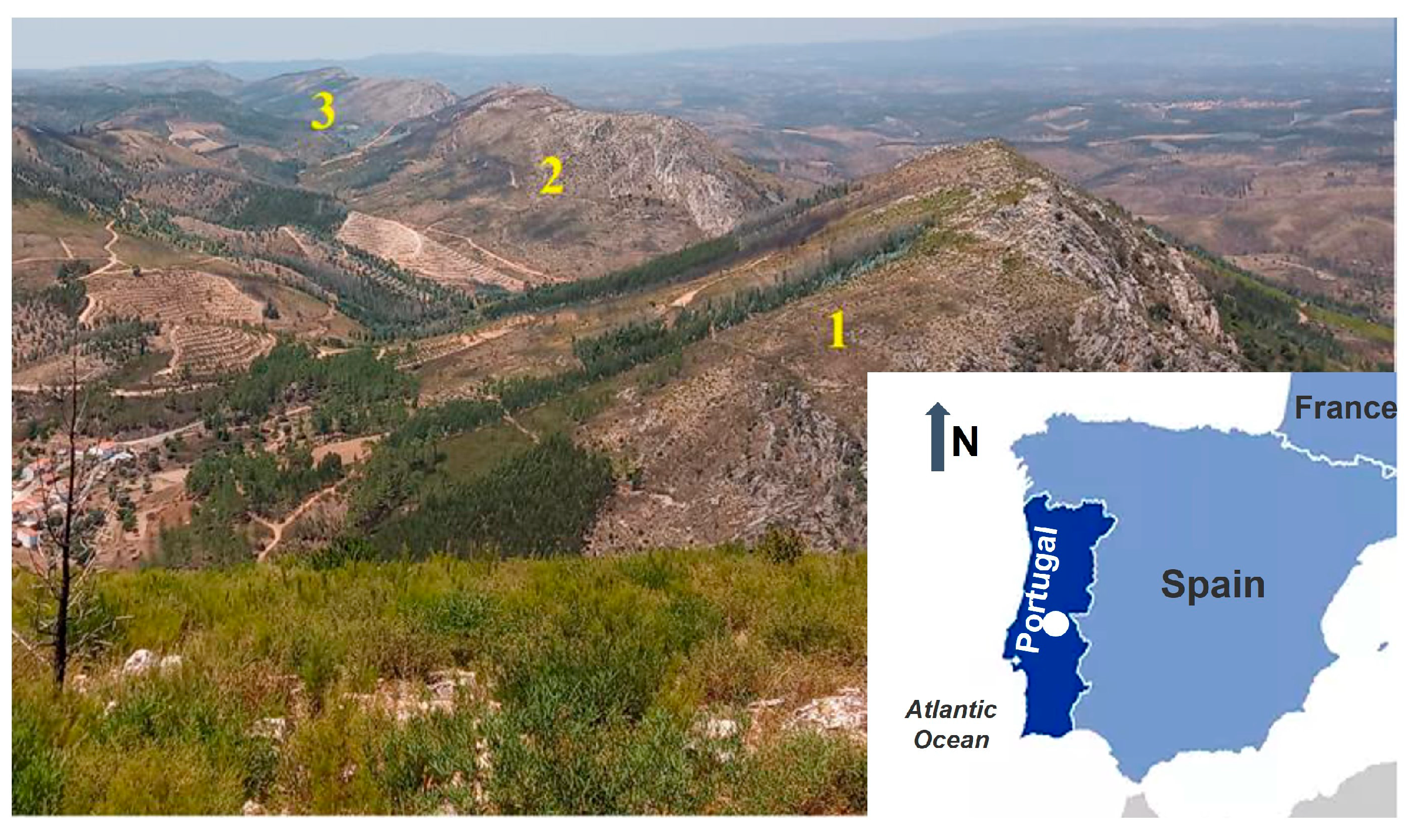
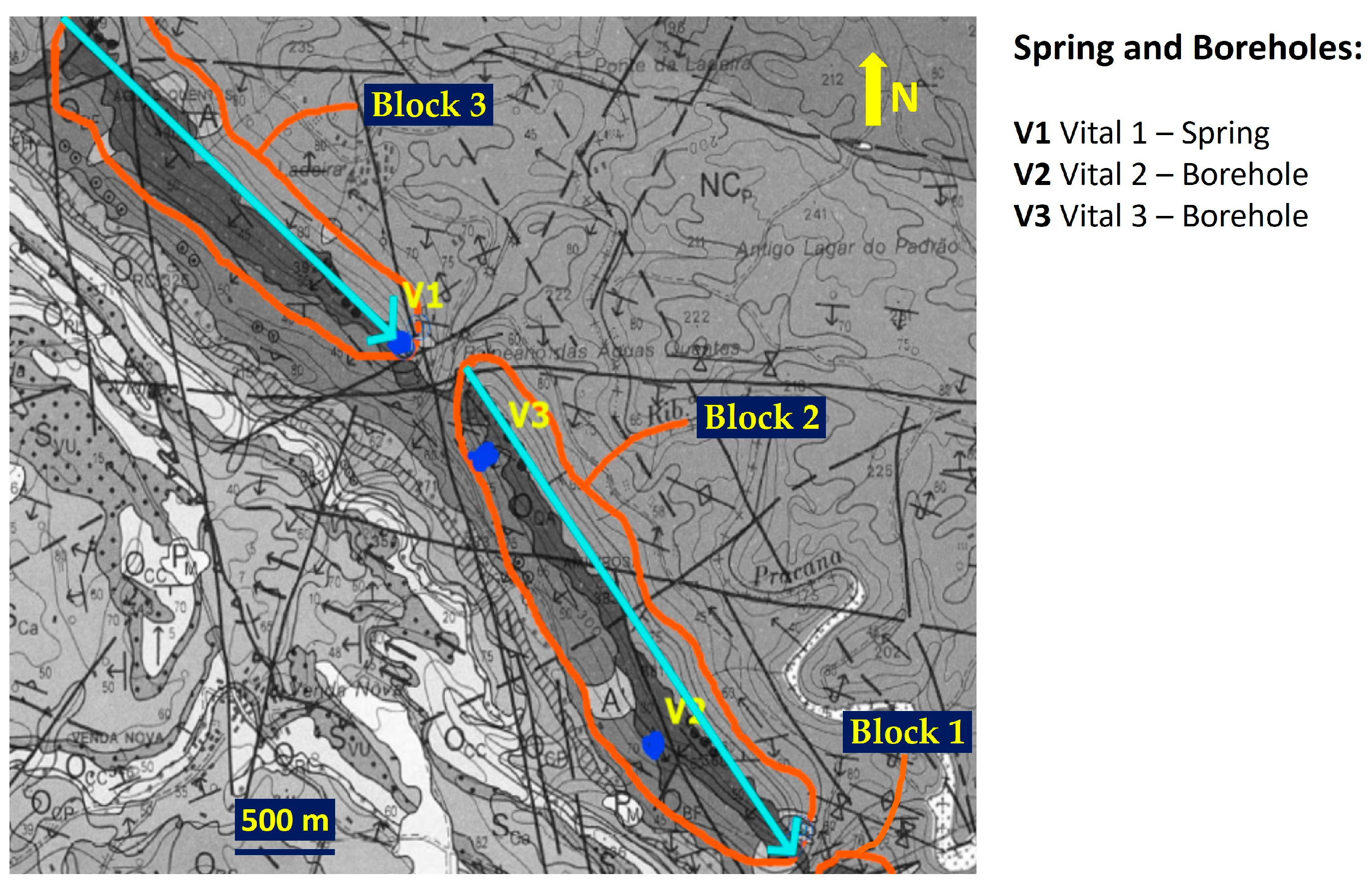
2. Regional Geological, Tectonic, Hydrogeological, and Climatological Framework

According to [10], the geological structure of the Ladeira de Envendos region is strongly controlled by the Amêndoa-Carvoeiro synform, of Ordovician-Silurian age, WNW–ESE oriented. The Amêndoa-Carvoeiro synform is described by [10] as presenting continuous and aligned quartzite ridges on both flanks that form the skeleton of a set of inselbergs: these units are the so-called Serra da Moita da Asna, Serra da Amieirosa, and Serra das Águas Quentes, marked in Figure 1 as 1, 2, and 3, respectively.
The subdivision of these three mountain ranges results from the action of local tectonics (deep faults), with an ENE–WSW orientation [10], ascribed to the discharge sites of the hydromineral system. In fact, at Ladeira de Envendos, these faults represent preferential pathways for natural mineral waters to rise to the surface, emerging in the form of springs, with these sources heterogeneously distributed in the three inselbergs shown in Figure 1, with the predominant occurrences in the extreme SE of each one of the blocks, which seems to indicate that groundwater circulation occurs along the NW–SE direction.
The description of the regional geology made by [10] highlights the predominant geological formations in the Amêndoa-Carvoeiro synform, essential for the hydrogeological control of the hydromineral system of Ladeira de Envendos, namely the following:
-
Brejo Fundeiro (middle Ordovician)—consisting of a high fossiliferous pelitic sequence intercalated with thin quartzite bands and siltstones;
-
Armorican quartzite (early Ordovician)—involving, from base to top, arkose conglomerates followed by a series of quartzite benches with a thickness between 0.3 and 1.5 m. Silt-arenitic strata and siltstones of small size intercalated with quartzites and pelites, with a thickness of about 80 m.
-
Padrão-Silveira (Schist-Greywacke complex–pre-Ordovician)—with great expression in the study region, outcropping around the Amêndoa-Carvoeiro synform. This geological formation consists of a succession of metagreywackes with metapelites of a few tens of meters.
The Armorican quartzite formation was highlighted by [10] due to its excellent hydrogeological significance ascribed to the high fracture permeability. According to [11], these types of geological formations are characterized by the absence or reduced groundwater circulation in porous media. The Armorican quartzite outcrops (see Figure 2) constitute ridges in the Amêndoa-Carvoeiro synform and are fitted underneath by the Schist-Greywacke complex (see Figure 3) and superiorly by the Brejo Fundeiro formation, both impermeable geological formations, guiding groundwater recharge to flow alongside the quartzite formation, avoiding lateral flow. A similar framework was described by [3].
The climate is temperate Mediterranean [13], with a two-month dry period in July and August. According to [13], the average air temperature for the Ladeira de Envendos region is 14.1 °C. Annual rainfall is 2744 mm (in the northern part of the basin and at altitudes greater than 1300 m) and 524 mm (in the southern part of the basin, closer to the study region). As stated by [13], according to the climate classification system established by [14], in the Tagus River Basin, where the study region is located, we can observe some climate variability ranging from super-humid climate (A) to dry sub-humid (C1).

3. Materials and Methods

To carry out this study, 3 representative sampling sites of the Ladeira de Envendos hydromineral system were considered (Ladeira de Envendos spring—Vital 1, and the boreholes Vital 2 and Vital 3) for which, there is a physico-chemical database (2010 to 2019). The Super Bock Group Enterprise (Concessionaire of the natural mineral waters and Ladeira de Envendos) kindly provided this record. The boreholes have very similar depths, namely the following: Vital 2 reached a depth of 218 m, and the borehole Vital 3 a depth of 208 m. In the case of Vital 2 borehole, static initial level—24.5 m; dynamic level—until 60 m. For Vital 3 borehole, static initial level—71.3 m; dynamic level—until 80 m. In the Vital 1 spring, used for bottling and spa treatments, the flow rate varies naturally along the hydrological year, rising with the recharge and decreasing with the natural discharge. In 2018, the maximum flow rate was 19.8 m3/h and the minimum flow rate was 11.0 m3/h. In 2019, the maximum flow rate was 16.7 m3/h and the minimum flow rate was 12.6 m3/h.
In addition to the above-mentioned sampling sites, it was also essential to carry out two field work campaigns (as a complement to information from the 2010 to 2019 database provided by the Super Bock Group Enterprise) to collect samples of “normal” groundwaters from Ladeira de Envendos region (springs Cabroeira direita CD, Cabroeira esquerda CE, Charneira 1 C1, Charneira 2 C2, and Pego da Rainha PR), for (i) in situ measurements—temperature T °C, pH, electrical conductivity EC μS/cm, and redox potential Eh mV (given with respect to the reference (H+/H2), using a portable Hach HQ40D Digital two-channel multi-meter (Hach Company, Colorado, USA), and (ii) isotopic (δ2H, δ18O and 3H) determinations. No water samples were collected for chemical analysis. The two sampling campaigns took place during summer (July 2019) and winter (January 2020). It is important to reference that of the several sampling sites, only Vital 1, Vital 2, and Vital 3 are regularly monitored and exploited by the Super Bock Group. The Bica da Estrada spring BE sampling site (although not exploited by the Super Bock Group) was also considered as natural mineral water, given that it is a spring located close to the road, near the Ladeira de Envendos Spa, where the local population obtains its natural mineral water in an outlet from Vital 1. The remaining selected sampling sites, although having physical-chemical characteristics rather similar to the above-mentioned sampling sites, were considered as “normal” groundwaters of the region. The set of sampling points was selected to be representative of groundwaters (natural mineral waters and “normal” groundwaters) associated with the Amêndoa-Carvoeiro synform, considering the groundwater sampling on the three continuous and aligned quartzite ridges, because of the compartmentation of Ladeira de Envendos aquifer system ascribed to the local tectonics (a detailed explanation will be given in the following section of this paper).
For the sampling sites, Vital 1, Vital 2, and Vital 3, regularly monitored, the following analytical standard methods were employed by the Super Bock Group: bicarbonate—SMEWW 2320 B (titration method); silica—M.M. 2.2.7 (speciation calculations). By ionic chromatography: chloride, sulphate and nitrate—SMEWW 4110 B; sodium, potassium, calcium and magnesium—M.M. 6.1.1.
For the determination of δ2H and δ18O values in the natural mineral waters and “normal” groundwaters of the study region, 50 mL of water were collected from each selected sampling site. The water samples were stored in high-density polyethylene bottles with double lids, to avoid isotopic fractionation. The stable isotopic determinations (δ2H and δ18O) were carried out at the Laboratório de Isótopos Ambientais of C2TN/IST (Centro de Ciências e Engenharias Nucleares do Instituto Superior Técnico) using a Laser Spectroscopic Analyzer LGR DT-100 24d (Los Gatos Research Inc., USA). The accuracy is ±1‰ for δ2H and ±0.1‰ for δ18O. The results are reported in delta (δ) notation and referenced to the international V-SMOW standard [15].
The method used for the determination of tritium content consists of distillation, electrolytic enrichment, neutralization, and measurement by liquid scintillation spectrometry using the PACKARD TRI-CARB 4530 scintillator (PACKARD, USA), as described in [16]. Tritium concentrations are expressed in Tritium Units (TU), being the error associated with the measurements usually varying around 0.6 TU, a function of the tritium content in the water sample.

4. Results

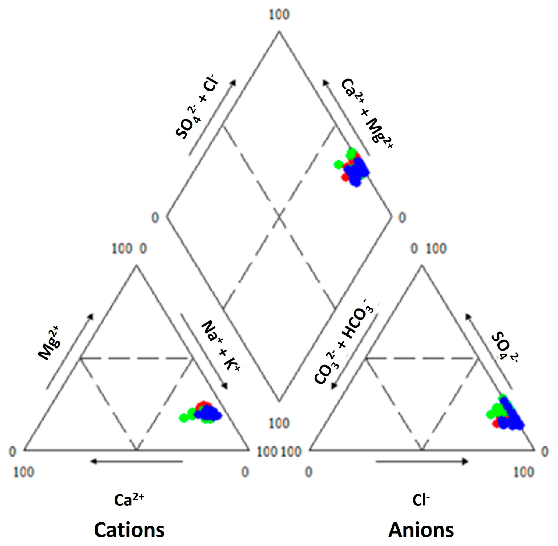
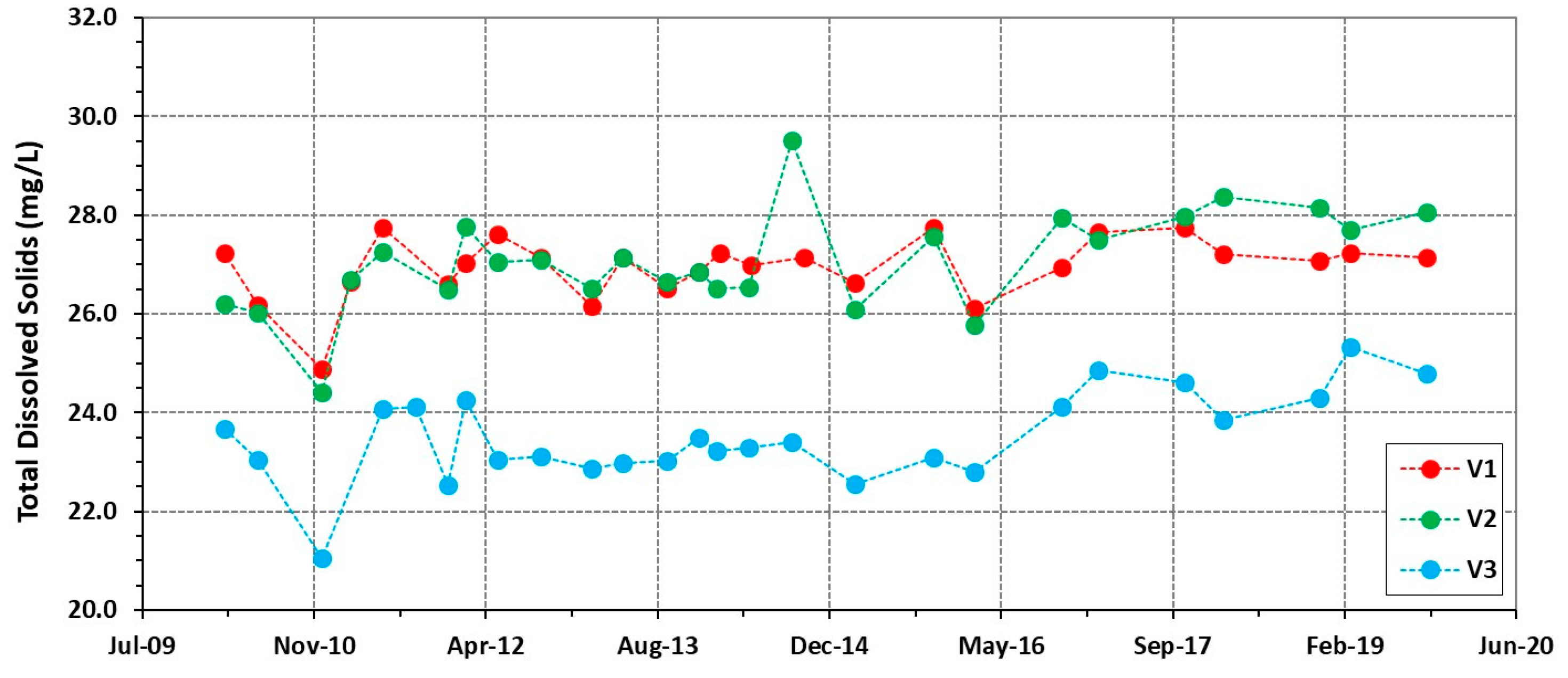
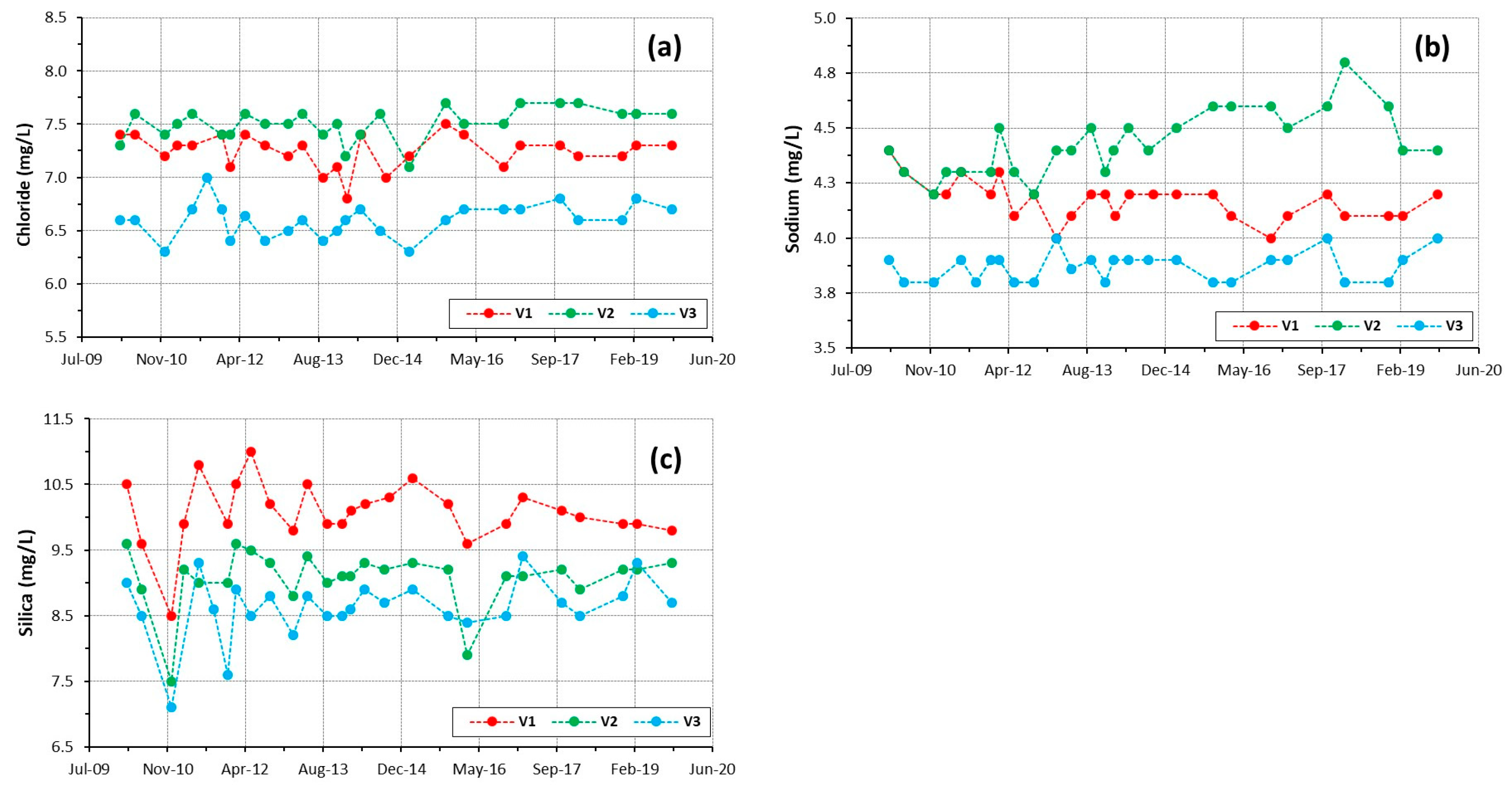
4.1. Physico-Chemical Signatures of the Waters

Hydrogeochemistry has an important role in the assessment of groundwater systems, namely natural mineral waters. Physical and chemical signatures of the natural mineral waters can be extremely useful to (i) infer the origin and type of groundwater recharge, (ii) enhance groundwater flow paths, (iii) interpret interactions between groundwaters and the aquifer matrix, and (iv) adjust conceptual groundwater circulation models, e.g., [11,17].
Figure 4 shows the locations of the natural mineral waters and “normal” groundwaters sampling sites. In the two field work campaigns carried out both in the Ladeira de Envendos hydromineral system and in the “normal” groundwaters of the region, the homogeneity of the pH, Eh, and EC is evident. Both natural mineral and “normal” groundwater samples present acidic pH values, ranging between 4.16 and 5.73, considering the logarithmic scale used to specify the acidity or basicity of aqueous solutions. The natural mineral waters from the Ladeira de Envendos present a mean pH value of 4.50. At all sampled sites, the Eh values range between 83.4 and 171.3 mV. The natural mineral waters from the Ladeira de Envendos present a mean Eh value of 154.7 mV. In all groundwater samples, EC values are very low, ranging between 28.6 µS/cm and 60.3 µS/cm. The natural mineral waters from the Ladeira de Envendos present a mean EC value of 44.6 µS/cm. The natural mineral and “normal” groundwaters of the study region have an emergence temperature higher than the average air temperature (14.1 °C [18]) of the region. It is important to note that in Portugal, the expression “thermal water” is often applied not only for natural mineral waters whose discharge temperature is above 20 °C, but also for natural mineral waters with discharge temperatures below 20 °C but used in spas for therapeutic purposes. Therefore, the use of the term “thermal water” for the waters under study is not easy to apply, given that the discharge temperatures of the natural mineral waters used in the Ladeira de Envendos Spa range between 19.2 °C and 23.0 °C, and the discharge temperature of the “normal” groundwaters of the region ranges between 13.3 °C and 22.2 °C. When comparing to the sampling campaign of July 2019, in January 2020 an average drop in the emergence temperature of the sampled groundwaters (of about 3.6 °C) was detected. In a first approach, this drop in temperature could be attributed to a problem with the temperature probe. However, it is important to note that the second field work campaign (January 2020) was carried out during a cold winter, and the above-mentioned temperature variation can be attributed to having placed the water inside a small container to insert the probes for the various in situ determinations. Therefore, the results of the water temperature determinations during the second field work campaign must be regarded with some restrictions. The results obtained can be observed in Table 1.
Using the data series (2010–2019) made available by the Super Bock Group, the natural mineral waters from Vital 1 spring and the Vital 2 and Vital 3 boreholes were projected in a Piper diagram using the United States Geological Survey’s GW_Chart software, version 1.3, and are represented in Figure 5, where it can be seen that the natural mineral waters of Ladeira de Envendos have the same hydrogeochemical facies, belonging to the Cl-Na-type waters, similar with the results presented by [3,6] for similar hydrogeologic environments.
As previously mentioned, the Ladeira de Envendos hydromineral system is characterized by the presence of natural mineral waters with very low mineralization. Nevertheless, by observing the diagram of Figure 6 (total mineralization versus time), it is possible to verify the similarity in the total mineralization content of Vital 1 spring and Vital 2 borehole natural mineral waters, which present, over time, a higher total mineralization than the natural mineral waters of borehole Vital 3, although all of them show a similar distribution pattern of the mineralization, over time. It is important to note that the ionic balance was calculated for all water analyses and the results vary in V1 from 0.11 to 3.86% (V1 mean ionic balance = 0.88 ± 1.42%; n = 24); V2 ionic balance shifts between 0.1 and 7.1% (V2 mean ionic balance = 1.58 ± 2.09%; n = 25); and in V3 borehole, the ionic balance ranges between 0.2 and 4.0% (V3 mean ionic balance = 0.79 ± 1.92%; n = 24). The ionic balance obtained is acceptable, according to [17].
In a first approach, the higher common decrease in the three sampling sites in December 2010 (Figure 6) can be interpreted as a sampling/analytical error, with small significance and never repeated (the same explanation for the lowest silica values in Figure 7c). However, the calculated ionic balance for V1 is 0.27%, in V2 it is 6.80%, and in V3 it is 1.80%, so the hypothesis that the observed deviation in December 2010 could be attributed to analytical error does not seem feasible as a possible explanation for this behaviour, although the calculation of TDS is independent from the ionic determinations in the water samples. Therefore, this decrease could be interpreted as a natural variation of the system, within the acceptable fluctuations for this type of waters.
The diagrams of Figure 7a–c represent the concentration of the dominant ions (Na+) and (Cl) and silica (SiO2) over time. The previously mentioned trend is notable regarding the fact that the natural mineral waters from Vital 1 spring and Vital 2 borehole present higher Na+, Cl, and SiO2 contents, when compared to the natural mineral waters from borehole Vital 3.
Concerning Figure 7b, the values variation is in line with the admitted interval for natural mineral waters. Nevertheless, the Na+ increase might be explained considering the exploitation methodology used in the three sources. Vital 1 spring is an artesian source, where the use of the natural mineral water is made with no human intervention, whereas in Vital 2 and Vital 3 boreholes, the natural mineral water is pumped, 24/7, all over the year. The decrease in TDS registered in December 2010 (Figure 6) is mainly marked in Figure 7c by the silica content, since silica is the predominant solution species in the studied natural mineral waters (see Table 2), as a result of the water–quartzite rock interaction.
Using a series of chemical data from 2010 to 2019, provided by the Super Bock Group Enterprise, the average chemical composition of the natural mineral waters of Ladeira de Envendos hydromineral system (spring—Vital 1, and the boreholes Vital 2 and Vital 3) was calculated. The results obtained are presented in Table 2.
From the analysis of Table 2, one can observe that the natural mineral waters of Ladeira de Envendos are very low mineralized waters. It should be noted that silica is the chemical species with the highest content, followed by the chloride and sodium. The dry residue average values of the natural mineral waters from Vital 1 spring and the Vital 2 and Vital 3 boreholes is 30.57 ± 4.02 mg/L, 30.50 ± 5.52 mg/L, and 27.58 ± 4.80 mg/L, respectively. According to the European Classification [19], the natural mineral waters of Ladeira de Envendos are hyposaline waters, like the natural mineral waters described by [3,4,6].

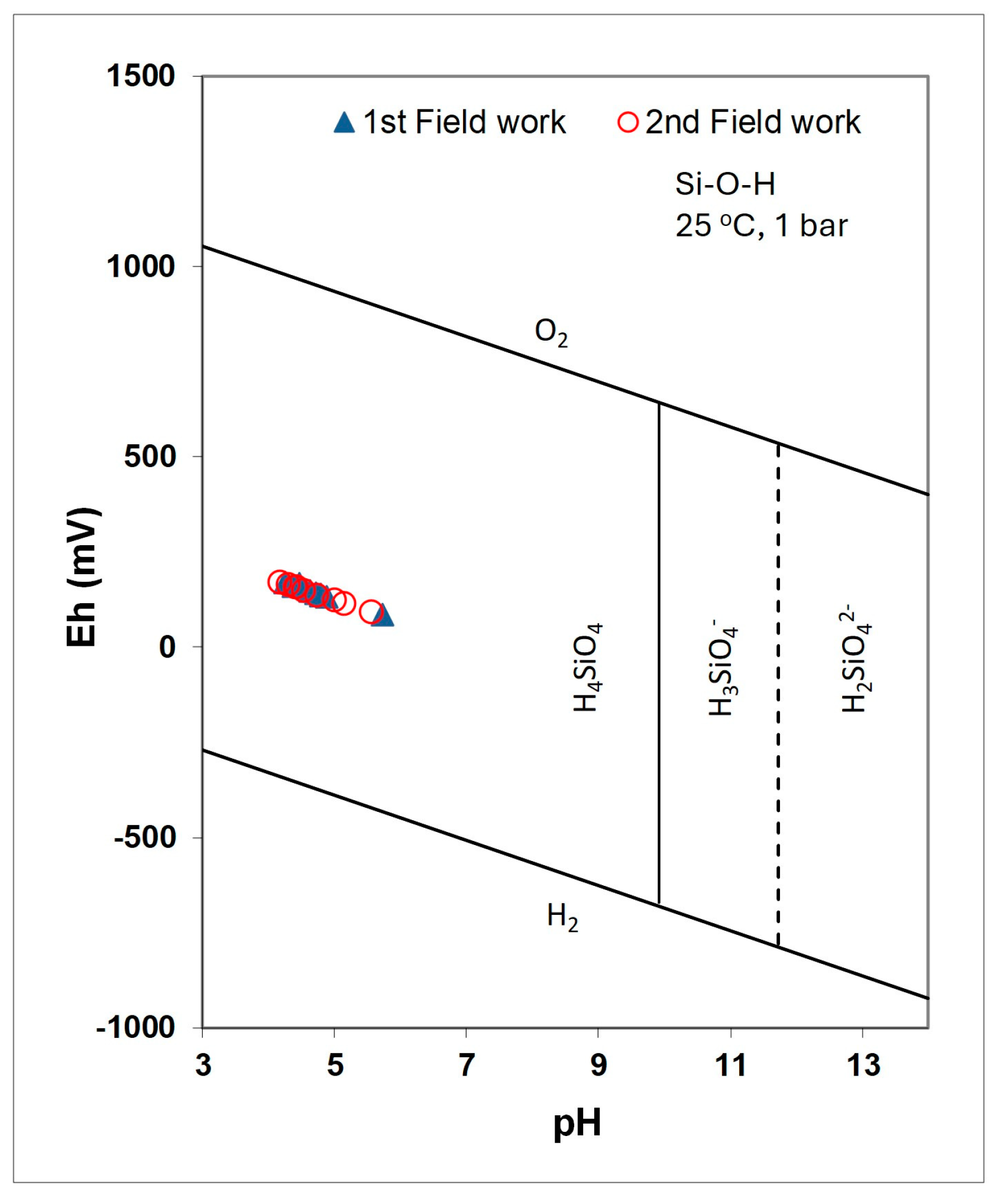
4.2. Chemical Geothermometers

The use of chemical geothermometers is an important tool in the study of hydromineral/hydrothermal resources, both in the exploration phase and during their exploitation, to assess the reservoir depth, or the effects of exploitation on the resource temperature, e.g., [20]. It should be noted that the Ladeira de Envendos hydromineral system is inserted in a quartzite formation where the mineral with the greatest expression in its composition is quartz (silica). Discharge temperatures are low, indicating cooling occurring essentially by conduction. Therefore, the geothermometer used in this case study was the silica (quartz) geothermometer proposed by [21], whose equation is as follows:
T(°C) = [1315/(5.205 − log SiO2)] − 273.15   SiO2 in mg/L
This geothermometer usually presents more consistent results when applied to hydrothermal systems with low discharge temperatures, as is the case in the present study (see [20,21] and references therein). Table 3 reports the results of the application of this geothermometer to the natural mineral waters of the Ladeira de Envendos hydromineral system (Vital 1 spring, and Vital 2 and Vital 3 boreholes). The maximum circulation depths of the natural mineral waters under study are also presented.

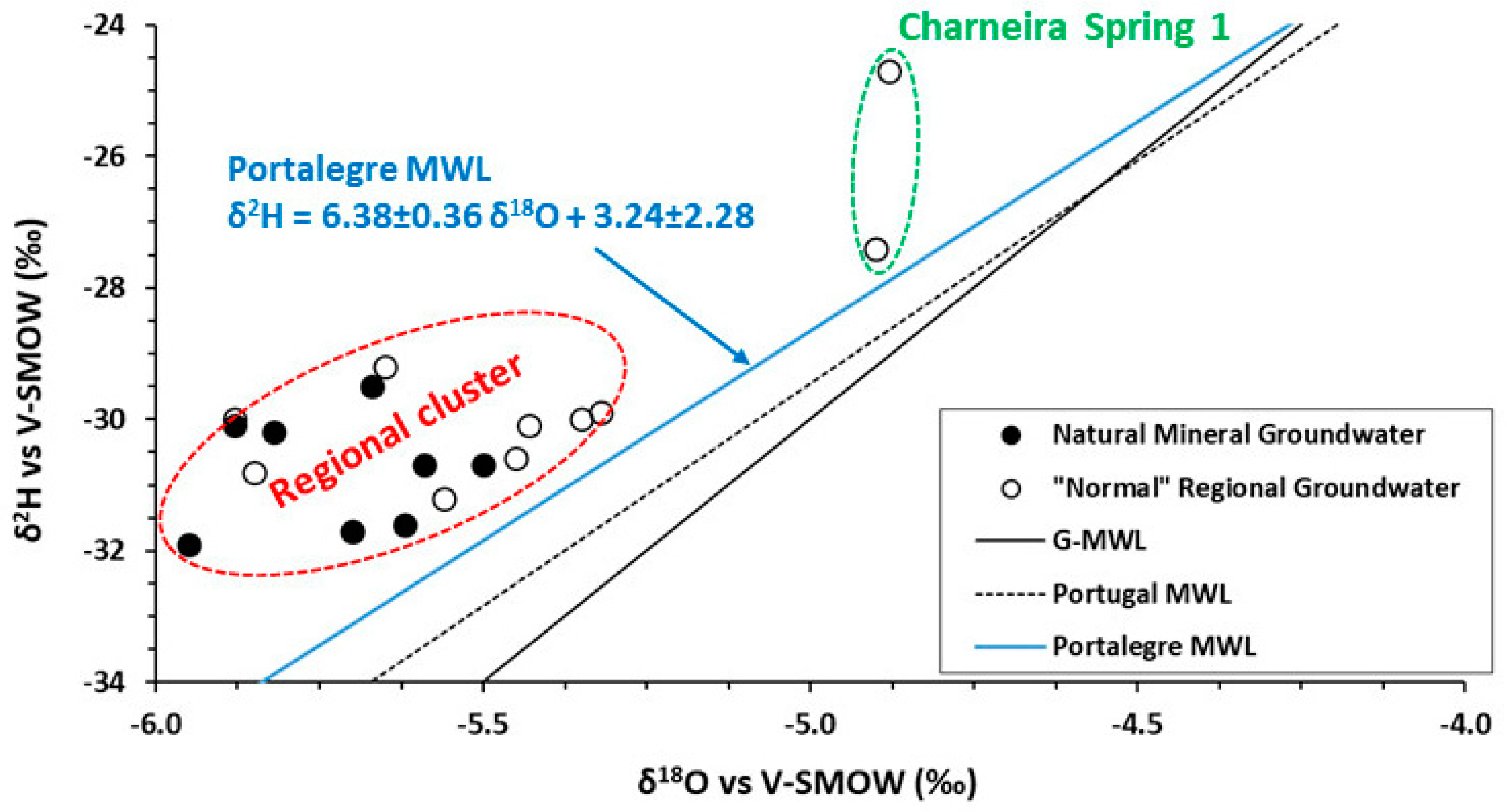
4.3. Isotopic (δ2H, δ18O and 3H) Signatures of the Waters

The application of isotopic techniques (δ2H, δ18O and 3H determination) to hydrological studies has been developed since the beginning of the 1930s until the present day, showing a strong increase after the 1950s [22]. The use of isotopic methodologies, alone or together with traditional hydrological techniques (hydrodynamic, hydrogeological, hydrogeochemical, hydrogeophysical, etc.), have played a fundamental role in the investigation of hydromineral systems, namely in defining potential recharge areas, determining the underground flow paths, dating groundwater systems, identifying mixing processes between different aquifer units, etc. (e.g., [23,24,25,26]).
The isotopic composition (δ18O and δ2H values) of the natural mineral waters samples collected from the Ladeira de Envendos hydromineral system (from Vital 1 spring, and Vital 2 and Vital 3 boreholes) and from the “normal” groundwaters of the region (Cabroeira direita, Cabroeira esquerda, Charneira 1, Charneira 2, and Pego da Rainha springs) are presented in Table 4.
The δ18O values of the sampled waters vary between −5.95 ‰ (at Vital 3 sampling site—2nd campaign) and −4.88 ‰ (at the Charneira 1 sampling site—2nd campaign). The δ2H values vary between −31.9 ‰ (at Vital 3 sampling site—2nd campaign) and −24.7 ‰ (at the Charneira 1 sampling site—2nd campaign). From Table 4, it should be noted that the isotopic composition of the Charneira 1 sampling site is rather different (more enriched in heavy isotopes) from the isotopic composition of the other (natural mineral and “normal”) sampled groundwaters (see Figure 8).
The determination of 3H content was also carried out in the same samples for the δ18O and δ2H measurements. The results obtained are shown in Table 5.

5. Discussion

5.1. Physico-Chemical Signatures of the Waters

All the sampled groundwaters are hyposaline waters, typical of interaction with quartzite geological formations. At all sampling sites, the redox potential values are positive, which reveals that both natural mineral waters and “normal” groundwaters of the region are oxidizing waters. These results are in line with what was mentioned by [11] when they point out that for systems with a poorly developed soil layer, superimposed fractured rock formations, it is usual to record positive Eh values due to the good oxygenation of the system. In fact, Eh data can become very useful if used as an indicator over time and/or with other common parameters to help develop a complete picture of the water quality being monitored [11]. Although the studied natural mineral waters and “normal” groundwaters of the region present relatively similar EC values, it should be noted that in the groundwaters from the Charneira 1 spring, a significant increase in EC was recorded between the 1st (EC = 28.6 µ/cm—July 2019) and the 2nd (EC = 60.3 µ/cm—January 2020) field work campaigns. This increase in the mineralization could be ascribed to the mixing of groundwaters circulating in quartzite formations with shallow groundwaters resulting from a strong component of surface runoff (during winter—in summer the local climate is very dry), which may have led to an increase in water mineralization. Unfortunately, we do not have EC determinations for surface waters during the 2nd field work campaign (22 January 2020), due to the absence of surface flow at the time of sampling. However, field observations made during this campaign indicate the possibility of considerable surface runoff in Block 1 (see location of the Charneira 1 spring in Figure 4). Furthermore, the increase in tritium content in Charneira 1 spring waters in the winter field work campaign (see Table 5) seems to confirm this input, although it is difficult to calculate the mixing percentage as we are missing one of the end-members. Concerning Charneira 1 spring waters, it should be noted that during the 2nd field work campaign (January 2020), the pH decreases, EC increases, T decreases, and Eh increases (see Table 1).
Considering the acidic nature of the sampled groundwaters (4.16 < pH < 5.73), two systems could control the evolution of pH: SiO2/H4SiO4 and H2CO3/HCO3. However, in such type of groundwaters ascribed to water–rock interaction with quartzite rocks, the bicarbonate content is very weak (see Table 2) and it is the silica system which controls the pH [29] (see Figure 9).
Moreover, the region under study is characterized by steep slopes, with little agriculture and vegetation consisting essentially of small shrubs and thin soils. The fact that in all sampling sites Eh values of the groundwaters are positive (83.4 < Eh < 171.3 mV), indicating the presence of oxidizing waters, is in line with what was reported by [11] for the case of hydrogeological systems associated with a poorly developed soil layer like the Ladeira de Envendos system. This soil layer is overlying fractured rocks (e.g., quartzites), where it is common to record high redox potential values due to the good oxygenation. Considering the detected average drop in the emergence temperature of the sampled waters (natural mineral waters and “normal” groundwaters of the region) of about 3.6 °C, from the Summer—July 2019 to the Winter—January 2020 field work campaign, one must consider the influence of air temperature on temperature fluctuations in the region’s groundwaters, which should not be associated with very deep circulation.
Water–quartzite rock interaction is responsible by the chemical composition of the studied natural mineral waters, resulting in the low mineralization of these waters and the predominance of silica in solution (see Table 2). Therefore, the Cl-Na facies (see Figure 5) presented by these natural mineral waters should be ascribed to the chemical composition of the regional precipitation, coming from the Atlantic (recharge waters). Cl and Na concentrations in rain waters from Portugal, namely Na+ = 5.6 mg/L and Cl = 9.5 mg/L, were mentioned by [30].
Considering that the geological environment (quartzite rocks) is similar and relatively homogeneous in the sampling sites Vital 1, Vital 2, and Vital 3, the higher total mineralization of the natural mineral waters from Vital 1 spring and Vital 2 borehole, when compared to the natural mineral waters of Vital 3 borehole (see Figure 6), appears to be associated with longer underground flow paths promoting higher water–rock interaction, from recharge to discharge. This fact seems to indicate that underground water circulation should occur in the NW–SE direction, in the three geomorphological units (inselbergs blocks) presenting similar hydrogeological characteristics. It seems that the infiltrated waters which evolve to natural mineral waters from Vital 1 spring and Vital 2 borehole circulate throughout the entire extent of the blocks in which they are inserted, while Vital 3 borehole intercepts the hydromineral system at a depth very close to the recharge area, exploiting natural mineral waters with a shorter underground flow path and consequently lower mineralization (see Figure 10). Furthermore, the tritium content in Vital 3 and Vital 2 boreholes, in the flow direction, seems to confirm this hypothesis.
From the diagrams of Figure 7a–c, the fact that the natural mineral waters from Vital 1 spring and Vital 2 borehole are those with the highest concentrations of dominant ions (Na+ and Cl) and silica (SiO2) over time corroborates the previously formulated hypothesis that the contact time with the rock matrix represents the dominant factor in the mineralization of these waters. Given that these are natural mineral waters whose circulation occurs in quartzite formations, the Cl-Na facies may be explained by the leaching of deposited NaCl salts (either in the soil or in the discontinuities of quartzite formations—diaclases, fractures, stratification) after several episodes of rain (recharge of the hydromineral system), as suggested by [31] in a similar case study. Therefore, the higher Na+ and Cl concentrations of the natural mineral waters from Vital 1 spring and Vital 2 borehole corroborate a NW to SE underground flow path. It should be noted that, in the case of very low mineralized waters, the observed stability in the chemical composition is a fundamental factor for their classification as natural mineral waters [19].

5.2. Chemical Geothermometers

The application of the silica chemical geothermometer [21] to the Ladeira de Envendos hydromineral system led to the estimation of relatively low reservoir temperatures at depth (see Table 3), indicating the presence of rather shallow circulation systems, explaining the low emergence temperature of these natural mineral waters. The estimation of the circulation depth of the natural mineral waters under study was carried out using the following equation,
Depth = (TReservoir − Tair)/GG
where
-
TReservoir is the reservoir temperature provided by the chemical geothermometer (in °C);
-
Tair is the average annual air temperature for the region (in °C);
-
GG is the geothermal gradient of the region (in °C/km),
considering that [32] suggests an average geothermal gradient of 33 °C/km in mainland Portugal and knowing the average annual air temperature for the region under study, which according to [18], has a value of 14.1 °C. Table 3 reports the estimated maximum circulation depths of the natural mineral waters under study, ranging from 0.63 to 0.78 km.

5.3. Isotopic (δ2H, δ18O and 3H) Signatures of the Waters

The isotopic composition of the natural mineral waters and the “normal” groundwaters of the study region were plotted in the δ2H-δ18O diagram of Figure 8. The set of water points projects close to the Global Meteoric Water Line G-MWL (δ2H = 8 × δ18O + 10 [27] and the Portugal Meteoric Water Line P-MWL (δ2H = 6.78 × δ18O + 4.45 [33] indicating the meteoric origin of these waters. Additionally, the regional meteoric water line, Portalegre-MWL, GNIP station between 1998 and 2004 [33], was plotted in the diagram. Although Portalegre station is located at an altitude of 780 m and around 55 km SE of the Ladeira de Envendos research area (mean altitude 400 m a.s.l.), these precipitation isotopic data were used to visualize the graphic distribution of the mineral water isotopic composition. The annual weighted isotopic composition of Portalegre GNIP station is δ18O = −5.60‰ and δ2H= −33.2‰ [33], relatively similar to the isotopic composition of the natural mineral water samples from the Ladeira de Envendos system, although these samples show a deviation towards more enriched isotopic values (see Table 4). Through the analysis of Figure 8, it was possible to verify that the sampled waters form a “cluster”, allowing to formulate the hypothesis that (except for the Charneira 1 spring) they can be considered as representative of the Ladeira de Envendos hydromineral system. Regarding groundwater samples from the Charneira 1 spring, the different signatures in relation to the “cluster” are notable not only in terms of the isotopic compositions, but also in terms of field parameters (in the January 2020 field work campaign, lower temperature T = 13.3 °C and higher EC = 60.3 µS/cm). This trend could be ascribed to a mixing process with shallow groundwaters that originated from surface runoff along the hill where this spring is located. However, this hypothesis is easily supported by the deviation observed in the first campaign performed during the dry season (July 2019), but is more difficult to accept during the rainy season where the use of water in agriculture is smaller. Nevertheless, the hypothesis to explain the observed isotopic enrichment in both sampling campaigns (in the dry and rainy seasons) at the Charneira 1 spring (Figure 8) can also be attributed to isotopic fractionation with altitude. This suggests a different preferential recharge area at lower altitudes and a shorter underground flow path when compared to the other springs analyzed. Both the stable isotope and the tritium content support this hypothesis (Table 4 and Table 5), being supported by the field data. Considering that the isotopic altitude effect in the Portuguese mainland is −0.2‰ per 100 m [33], a lower preferential recharge altitude for the Charneira 1 spring should be considered, at least 300 m of altitude difference between this spring and the Ladeira de Envendos hydromineral system. The observed behaviour/content fluctuation in all samples can be related to a “piston flow” circulation. The variations in the isotopic content can be ascribed to the seasonal isotopic signatures observed in the Portuguese regional precipitation database. It is important to mention that only two sampling campaigns for isotopic determinations have been conducted in the region, and further surveys are required.
Therefore, as previously mentioned, the groundwaters from Charneira 1 spring should not be considered as representative of the Ladeira de Envendos hydromineral system. The waters that form the “cluster”, with very homogeneous isotopic composition, seem to have similar recharge altitudes, on the top of the quartzite ridges (along the NE flank of the Amêndoa-Carvoeiro synform) which present altitudes be-tween 430 m a.s.l. at Serra das Águas Quentes and 370 m a.s.l. at Serra da Moita da Asna, as can be observed in Figure 11.
In the region, the deuterium excess (d) in all water samples collected in both campaigns varies between 11.8 and 17.0‰. The relation between the δ2H and δ18O values in the rain samples should be close to that defined by the Global Meteoric Water Line Equation (G-MWL), i.e., around 10 and 12‰. However, the deuterium excess values obtained at the stations located in continental Portugal (GNIP stations, part of the Portuguese Isotopes in Precipitation Network) show an increasing trend with distance from the coast and also with the altitude, i.e., the more continental stations, case of Portalegre and Penhas Douradas (Serra da Estrela) stations, present deuterium excess values of 12.9‰ and 15.4‰, respectively [33]. In addition, the highest excess deuterium values in the precipitation samples (monthly samples) in these stations were recorded during the winter precipitation, which can be attributed to the temperature differences between the colder atmospheric air and the ocean surface and the percentage of relative humidity. In the Portuguese Network of Isotopes in Precipitation, the relationship between deuterium excess values and annual averages weighted with the altitude of the stations is not unique. Such high d values were also mentioned in some stations in the southeast of Spain [34]. High values in the deuterium excess are often found in the precipitation of the western Mediterranean. The relationship between higher deuterium excess values at higher altitudes and during winter and autumn precipitation months was also reported by [35].
Considering the tritium content at Portalegre GNIP station, only records between 1988 to 1992 are available, with a weighted mean of 5.3 TU [36]. Because there are no regional data available on the tritium content in precipitation, it was assumed that the content of this radioactive isotope in the precipitation waters in mainland Portugal could vary between 3 TU and a maximum content of 4 TU. The current limitations of tritium data for estimating mean groundwater residence time were referred by [37], knowing that this radioisotope has returned to its natural atmospheric concentrations. These authors also mentioned the need to use time series of precipitation during the last 50 years. In the Ladeira de Envendos region, collecting this type of time series is a problematic issue since at the Portalegre GNIP station, the 3H record is only 4 years. Another hypothesis is to resort to another nearby station, i.e., the Penhas Douradas station. However, the possibility to complete the time series with Penhas Douradas data (located at 1380 m a.s.l. and about 100 km N, mountainous region) is also not feasible since the available 3H record overlaps the tritium data record between 1988 and 1999.
Since all groundwater samples have measurable tritium content, the natural mineral waters of the Ladeira de Envendos hydromineral system represent a system with a strong component of active recharge. Assuming a piston flow circulation, i.e., no groundwater mixing occurs by convergence of flow paths, dispersion and/or diffusion, the groundwater sample behaves as a “closed unit” from recharge to sampling point, and the apparent groundwater age inferred in this way will represent a single value corresponding to the integrated travel time of the water sample. So, assuming that the half-life of 3H is 12.32 years [22], it was feasible to estimate a maximum mean residence time, between 25 and 40 years, for the natural mineral waters from the Ladeira de Envendos hydromineral system.

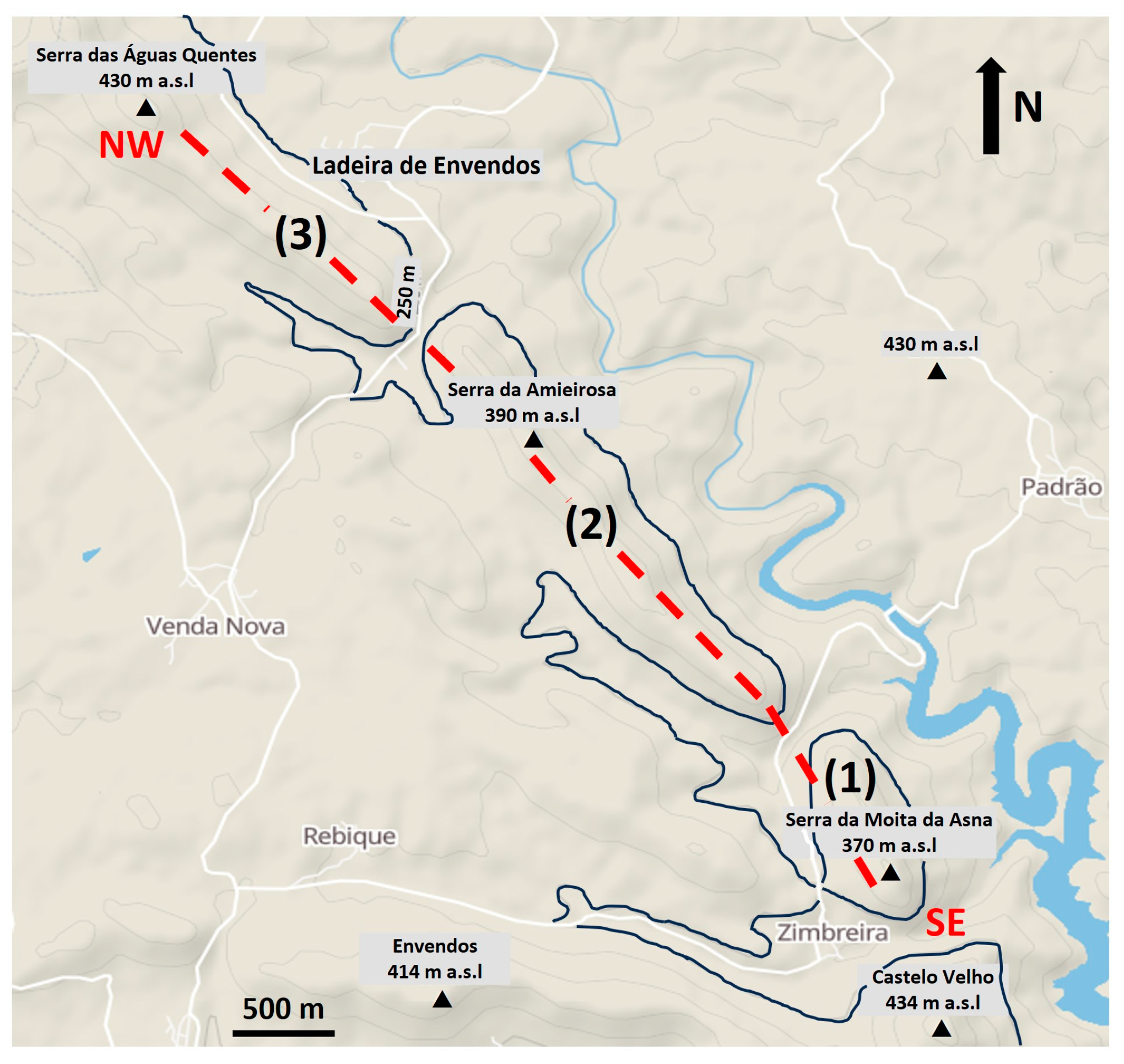
6. Contribution to the Update of the Conceptual Hydrogeological Circulation Model of the Ladeira de Envendos Hydromineral System

According to [38], a conceptual hydrogeological circulation model related to a given hydromineral system must be easy to “read”, mostly qualitative and comprise a physical explanation on how the hydromineral system works, including the general trend, with an emphasis on the content of the research developed. A conceptual hydrogeological circulation model generally involves schematic cross-sections and/or maps presenting the local/regional geology, preferential recharge areas, groundwater flow paths, water–rock interaction processes occurring at depth, and discharge locations, e.g., [39,40,41]. As recent data become accessible from the latest field work campaigns, a given conceptual hydrogeological circulation model should be updated over time.
The main objective of this study was to contribute to the improvement of the conceptual hydrogeological circulation model of the Ladeira de Envendos hydromineral system, which is schematically presented in Figure 12.
The Ladeira de Envendos hydromineral system has its origin in meteoric waters (1), infiltrated along the Serra das Águas Quentes, Serra da Amieirosa, and Serra da Moita da Asna mountains, at very similar recharge altitudes (approximately 410 m a.s.l.). The recharge is favoured by the heavily fractured quartzite ridges, favouring the heating (2) of the meteoric waters to temperatures up to 35 °C–40 °C (using the silica geothermometer [21]) and water–quartzite rock interaction (3), with the preferential dissolution of silica since quartz is the main mineral of quartzites. In addition, based on the above-mentioned temperatures, the maximum depth of circulation of Ladeira de Envendos natural mineral waters was estimated between 0.63 to 0.78 km. The fractured quartzite rocks, favouring the recharge, are also the means by which the natural mineral waters rise to the surface (4), being in some cases also favoured by the fault systems which divide the quartzite ridge into Blocks 1 (Serra da Moita da Asna), 2 (Serra da Amieirosa), and 3 (Serra das Águas Quentes). The natural discharge (5) of the system occurs, in the form of springs, with an issue temperature of about 21 °C on the southeast border of all of the blocks (the orange in Figure 11). Given the tritium content in the natural mineral waters analyzed (spring and boreholes), the circulation subsystems have an average residence time of between 25 and 40 years. By the “reading” of Figure 12, and in accordance with what was previously mentioned, it is visible that the Ladeira de Envendos hydromineral system is sorted into three subsystems with very similar characteristics (altitudes of recharge, underground flow paths, water–rock interaction processes, and average residence time—from recharge to discharge), strongly conditioned by the local/regional hydrogeological characteristics.
Figure 12. Schematic representation of the updated conceptual hydrogeological circulation model of the Ladeira de Envendos hydromineral system (not to scale). F stands for the major fault systems. The diaclases system of the quartzite rocks and associated groundwater flow paths have been simplified, in order not to overload the schematic cross section, although the diaclases are affecting the whole entire inselbergs, either all over the surface or at depth. Adapted from [9].
Sustainability 16 05179 g012
The results obtained with the multi and interdisciplinary study of the natural mineral waters of Ladeira de Envendos, when compared with the similar case studies presented in the “Introduction” of this paper, highlight the fact that when the hydrogeological frameworks are similar, the evolution of meteoric waters (recharge) through water–rock interaction (in these cases with quartzite rocks) give rise to very similar “end-members”: hyposaline natural mineral waters of Cl-Na facies, where silica is the chemical species that presents the highest concentration.
These results highlight the role of the conceptual hydrogeological circulation models to ensure a sustainable groundwater management. This updated conceptual model should be seen as a key tool for understanding the hydrodynamic functioning of the Ladeira de Envendos hydromineral system with a view towards future groundwater management strategies. This approach for the Ladeira de Envendos hydromineral system indicates its potential applicability to other hydromineral systems facing similar challenges.

7. Concluding Remarks

In this paper, through a multi and interdisciplinary approach, the formulated hypotheses were proven by the critical interpretation of data acquired from a wide spectrum of disciplines from the geosciences.
The geomorphology of the Ladeira de Envendos region is dominated by the Amêndoa-Carvoeiro synform, where the NE flank is divided into three blocks (inselbergs) split by major faults.
The geology is dominated by the Armorican quartzite formation, densely fractured, and bounded by the Brejo Fundeiro and Padrão-Silveira impermeable formations, contributing to a recharge from meteoric waters in the quartzite formations, without occurring lateral flow.
The Ladeira de Envendos hyposaline natural mineral waters (the dry residue does not exceed 30 mg/L) belong to the Cl-Na facies, and the presence of silica represents approximately one third of the total dissolved solids. The groundwater circulation occurs from NW to SE. Since the hydromineral system is separated in three blocks, the existence of three hydrogeological subsystems with similar groundwater circulation paths should be considered.
δ18O and δ2H values indicate that the sampled groundwaters can be considered as representative of the Ladeira de Envendos hydromineral system, whose recharge occurs at similar altitudes (around 400 m a.s.l.), along the quartzite ridges that comprise the various blocks on the NE flank of the Amêndoa-Carvoeiro synform. The 3H content in the natural mineral waters of Ladeira de Envendos shows the presence of a considerable modern recharge component and a mean residence time of between 25 and 40 years.
However, it will be important, in the future, to carry out new sampling campaigns, for physico-chemical and isotopic determinations at the same time of year, in order to update the proposed conceptual circulation model.

Author Contributions

Conceptualization, J.M.M., P.M.C., P.C. and M.A.d.S.; methodology, J.M.M., P.M.C. and P.C.; software, P.M.C. and P.C.; investigation, J.M.M., P.M.C. and P.C.; writing—original draft preparation, J.M.M., P.M.C., P.C. and M.A.d.S.; writing—review and editing, J.M.M., P.M.C. and M.A.d.S.; visualization, J.M.M. and P.M.C. All authors have read and agreed to the published version of the manuscript.

Funding

CERENA/IST author acknowledges the FCT support through FCT-UIDB/04028/2020 project. The author from C2TN/IST acknowledges FCT support through the strategic project FCT-UIDB/04349/2020.

Institutional Review Board Statement

Not applicable.

Informed Consent Statement

Not applicable.

Data Availability Statement

The original contributions presented in the study are included in the article, further inquiries can be directed to the corresponding authors.

Acknowledgments

The authors would like to thank the Super Bock Group Enterprise (Concessionaire of the natural mineral waters of Ladeira de Envendos) for their logistic support during the field work campaigns, and for kindly providing the physico-chemical database (2010 to 2019). An early draft of this manuscript was critically read by three anonymous reviewers, and we gratefully acknowledge their contributions. The authors also would like to acknowledge M.R Carvalho for Figure 9. The Academic Editor’s comments and suggestions are also acknowledged.

Conflicts of Interest

Author Manuel Antunes da Silva was employed by the company Super Bock Group. The remaining authors declare that the research was conducted in the absence of any commercial or financial relationships that could be construed as a potential conflict of interest.

References

  1. Lepierre, C. (1930/31) Chimie et physico-chimie des eaux. Port. Hydrol. Clim. 1930/31, 1, 75–106. [Google Scholar]
  2. APIAM. Águas Minerais Naturais e Águas de Nascente. Livro Branco, 1st ed.; APIAM: Lisboa, Portugal, 2015; pp. 12–62. (In Portuguese) [Google Scholar]
  3. Vieira da Silva, A.M.; Condesso Melo, M.T.; Marques da Silva, M.A. Modelo conceptual e caracterização hidrogeológica preliminar do sistema aquífero da Serra do Buçaco. In Proceedings of the Actas das Jornadas Luso-Espanholas sobre As Águas Subterrâneas no Noroeste da Península Ibérica, La Coruña, Espanha, 3–6 July 2000. (In Portuguese). [Google Scholar]
  4. Cortez, S. Águas Minerais Naturais e de Nascente da Região Centro, 1st ed.; Mare Liberum: Aveiro, Portugal, 2012; pp. 483–485. (In Portuguese) [Google Scholar]
  5. Madureira de Sousa, A.A. Estudo de Sistemas Hidrogeológicos no Norte e Centro de Portugal. MSc Thesis, Departamento de Geociências, Ambiente e Ordenamento do Território, Faculdade de Ciências, Universidade do Porto, Porto, Portugal, 2015. [in Portuguese]. [Google Scholar]
  6. Almeida, A.M.; Dias, D.; Almeida, M.; Marques, J.M.; Antunes da Silva, M. Contribuição para o desenvolvimento do modelo conceptual de circulação da Água Mineral Natural de Castelo de Vide. In Proceedings of the 12th Seminário Sobre Águas Subterrâneas, Coimbra, Portugal, 7–8 March 2019. (In Portuguese). [Google Scholar]
  7. Henriques, F.F. Aquilégio Medicinal; Oficina da Música: Lisboa, Portugal, 1726; p. 48. (In Portuguese) [Google Scholar]
  8. Wang, L.; Xiao, Y.; Yang, H.; Zhang, Y.; Wang, S.; Qi, Z.; Han, J.; Hu, W.; Wang, J.; Hao, Q.; et al. Formation mechanism of high-altitude glacial mineral water in the Kunlun Mountains of Tibetan Plateau: Insights from isotopes and hydrochemistry. J. Hydrol. Reg. Stud. 2024, 53, 101789. [Google Scholar] [CrossRef]
  9. Caçador, P. Elaboração de um Modelo Interpretativo do Aquífero Hidromineral de Ladeira de Envendos. Master’s Thesis, Instituto Superior Técnico, Lisboa, Portugal, 2021. (In Portuguese). [Google Scholar]
  10. Romão, J.; Esperancinha, A. Carta geológica de Portugal-Folha 28-A Mação. Nota Explicativa, 1st ed.; Departamento de Geologia, Instituto Nacional de Engenharia, Tecnologia e Inovação: Lisboa, Portugal, 2006; pp. 1–77. [Google Scholar]
  11. Freeze, A.R.; Cherry, J.A. Groundwater; Englewood Cliffs: Prentice-Hall, NJ, USA, 1979; pp. 82–134. [Google Scholar]
  12. HM-27—Ladeira de Envendos. Available online: https://hidrogenoma.dgeg.gov.pt/agua-mineral-natural/ladeira-de-envendos (accessed on 13 November 2023).
  13. Cordovil, C.M.S.; Cruz, S.; Brito, A.G.; Cameira, M.R.; Poulsen, J.R.; Thodsen, H.; Kronvang, B. A simplified nitrogen assessment in Tagus River basin: A management focused review. Water 2018, 10, 406. [Google Scholar] [CrossRef]
  14. Thornthwaite, C.W. An approach toward a rational classification of climate. Geogr. Rev. 1948, 38, 55–94. [Google Scholar] [CrossRef]
  15. IAEA. Training Course Series 35 Laser Spectroscopic Analysis of Liquid Water Samples for Stable Hydrogen and Oxygen Isotopes. Performance Testing and Procedures for Installing and Operating the LGR DT-100 Liquid Water Stable Analyser, 1st ed.; International Atomic Energy Agency: Vienna, Austria, 2009; pp. 1–27. [Google Scholar]
  16. IAEA. Procedure and Technique Critique for Tritium Enrichment by Electrolysis at IAEA Laboratory, 1st ed.; Technical Procedure nº19; International Atomic Energy Agency: Vienna, Austria, 1976; pp. 1–42. [Google Scholar]
  17. Appelo, C.A.J.; Postma, D. Geochemistry, Groundwater and Pollution, 1st ed.; Balkema: Rotterdam, The Netherlands, 1993; pp. 1–168. [Google Scholar]
  18. IPMA. Available online: http://portaldoclima.pt/pt/ (accessed on 13 December 2020).
  19. Directive 2009/54/EC. Available online: http://data.europa.eu/eli/dir/2009/54/oj (accessed on 15 November 2023).
  20. Fournier, R.O. Chemical geothermometers and mixing models for geothermal systems. Geothermics 1977, 5, 41–50. [Google Scholar] [CrossRef]
  21. Truesdell, A.H. Summary of Section III. Geochemical techniques in exploration. In Proceedings of the Second United Nations Symposium on the Development and Use of Geothermal Resources, Lawrence Berkley Laboratory, University of California, San Francisco, CA, USA, 20–29 May 1975. [Google Scholar]
  22. Mook, W.G. Environmental Isotopes in the Hydrological Cycle: Principles and Applications, 1st ed.; IHP-V Technical Documents in Hydrology No. 39; UNESCO: Paris, France, 2000; Volume 1, pp. 89–142. [Google Scholar]
  23. Giggenbach, W.; Gonfiantini, R.; Jangi, B.L.; Truesdell, A.H. Isotopic and chemical composition of the Parbati Valley geothermal discharges, North-West Himalaya, India. Geothermics 1983, 12, 199–222. [Google Scholar] [CrossRef]
  24. Albu, M.; Banks, D.; Nash, H. Mineral and Thermal Groundwater Resources, 1st ed.; Chapman and Hall: London, UK, 1997; pp. 48–144. [Google Scholar]
  25. Aggarwal, P.K.; Froehlich, K.; Gonfiantini, R.; Gat, J.R. Isotope hydrology: A historical perspective from the IAEA. In Isotopes in the Water Cycle. Past, Present and Future of a Developing Science, 1st ed.; Aggarwal, P.K., Gat, J.R., Froehlich, K.F.O., Eds.; Springer: Dordrecht, The Netherlands, 2005; pp. 3–8. [Google Scholar]
  26. Marques, J.M.; Carreira, P.M.; Aires-Barros, L.A.; Monteiro Santos, F.A.; Antunes da Silva, M.; Represas, P. Assessment of Chaves Low-Temperature CO2-Rich Geothermal System (N-Portugal) Using an Interdisciplinary Geosciences Approach. Geofluids Spec. Issue—Geotherm. Syst. Interdiscip. Approaches Eff. Explor. 2019, 2019, 1379093. [Google Scholar] [CrossRef]
  27. Craig, H. Isotopic variations in meteoric waters. Science 1961, 133, 1702–1703. [Google Scholar] [CrossRef] [PubMed]
  28. Carreira, P.; Nunes, D.; Valério, P.; Araújo, M.F. A 15-year record of seasonal variation in the isotopic composition. J. Radioanal. Nucl. Chem. 2009, 281, 153–156. [Google Scholar] [CrossRef]
  29. Pourbaix, M. Atlas of Electrochemical Equilibria in Aqueous Solutions, 2nd ed.; National Association of Corrosion Engineers: Houston, TX, USA, 1974. [Google Scholar]
  30. Afonso, M.J.; Chaminé, H.I.; Carvalho, J.M.; Marques, J.M.; Gomes, A.; Araújo, M.A.; Fonseca, P.E.; Teixeira, J.; Marques da Silva, M.A.; Rocha, F.T. Urban groundwater resources: A case study of Porto City in northwest Portugal. In Urban Groundwater: Meeting the Challenge. Chapter 20—Urban Aquifer Management. International Association of Hydrogeologists Selected Papers, 1st ed.; Howard, K.W.F., Ed.; Taylor & Francis Group: London, UK, 2006; Volume 8, pp. 271–287. [Google Scholar]
  31. Almeida, A.M.; Dias, D.; Almeida, M.; Marques, J.M.; Antunes da Silva, M. Modelo Conceptual de Circulação da Água Mineral Natural de Castelo de Vide; Relatório de Estágio, Instituto Superior Técnico/Super Bock Group: Lisboa, Portugal, 2019; Unpublished Report. (In Portuguese) [Google Scholar]
  32. IGM. Recursos Geotérmicos em Portugal Continental (Baixa Entalpia), 1st ed.; Instituto Geológico e Mineiro: Lisboa, Portugal, 1998; pp. 8–22. (In Portuguese) [Google Scholar]
  33. Carreira, P.M.; Araújo, M.F.; Nunes, D. Isotopic composition of rain and water vapour samples from Lisbon region: Characterization of monthly and daily events. In Isotopic Composition of Precipitation in the Mediterranean Basin in Relation to Air Circulation Patterns and Climate; Final report of a Coordinated Research Project; 2005; IAEA-TECDOC-1453; pp. 141–156. Available online: https://www-pub.iaea.org/MTCD/Publications/PDF/te_1453_web.pdf (accessed on 13 November 2023).
  34. Cruz-San Julian, J.; Araguás-Araguás, L.; Rozanski, K.; Benavente, J.; Cardenal, J.; Hidalgo, M.C.; Garcia-Lopez, S.; Martinez-Garrido, J.C.; Moral, F.; Olias, M. Sources of precipitation over South-Eastern Spain and groundwater recharge. An isotopic study. Tellus 1992, 44B, 226–236. [Google Scholar] [CrossRef]
  35. Natali, S.; Doveri, M.; Giannecchini, R.; Baneschi, I.; Zanchetta, G. Is the deuterium excess in precipitation a reliable tracer of moisture sources and water resources fate in the western Mediterranean? New insights from the Apuan Alps (Italy). J. Hydrol. 2022, 614, 128497. [Google Scholar] [CrossRef]
  36. Carreira, P.M.; Valério, P.; Nunes, D.; Araújo, M.F. Temporal and seasonal variations of stable isotopes (δ2H and δ18O) and tritium in precipitation over Portugal. Proceedings of the International Conference Isotopes in Environmental Studies. Aquatic Forum 2004. IAEA-CSP-26, 2006, (IAEA-CN-118/63), 370–373. Available online: https://www.iaea.org/publications/7404/isotopes-in-environmental-studies-aquatic-forum-2004 (accessed on 13 November 2023).
  37. Ben Ammar, S.; Taupin, J.-D.; Alaya, M.B.; Zouari, K.; Patris, N.; Khouatmia, M. Using geochemical and isotopic tracers to characterize groundwater dynamics and salinity sources in the Wadi Guenniche coastal plain in northern Tunisia. J. Arid. Environ. 2020, 178, 104150. [Google Scholar] [CrossRef]
  38. Moore, J.E. Field Hydrogeology: A Guide for Site Investigations and Report Preparation, 1st ed.; Lewis Publishers: New York, NY, USA, 2002; pp. 47–59. [Google Scholar]
  39. Sharp, J.M., Jr. Fractured aquifers/reservoirs: Approaches, problems, and opportunities. In Proceedings of the Mem. 24th Congress of IAH, Part 1, Oslo, Norway, 28 June–2 July 1993. [Google Scholar]
  40. Brassington, F.C. A proposed conceptual model for the genesis of the Derbyshire thermal springs. Q. J. Eng. Geol. Hydrogeol. 2007, 40, 35–46. [Google Scholar] [CrossRef]
  41. Gu, X.; Zhang, Q.; Cui, Y.; Shao, J.; Xiao, Y.; Zhang, P.; Liu, J. Hydrogeochemistry and genesis analysis of thermal and mineral springs in Arxan, Northeastern China. Water 2017, 9, 61. [Google Scholar] [CrossRef]
Figure 1. The Amêndoa-Carvoeiro syncline (NE flank) and the tectonic structures (major faults) that control its division into three “inselbergs”: Serra da Moita da Asna (1), Serra da Amieirosa (2), and Serra das Águas Quentes (3). Photo by J.M. Marques (2020). Adapted from [9].
Sustainability 16 05179 g001
Figure 2. Simplified geological map of the region of the Ladeira de Envendos hydromineral system, showing the location of the spring (Vital 1) and bore hole (Vital 2 and Vital 3) natural mineral waters. (*) See text for details on these geological formations. Adapted from [12].
Sustainability 16 05179 g002
Figure 3. Example of the quartzite ridge in the Ladeira de Envendos region. Dashed line indicates the contact between the Armorican quartzite (1) and the Padrão-Silveira (2) geological formations. Photo by J. M. Marques (2019).
Sustainability 16 05179 g003
Figure 4. Location and discharge altitudes of groundwater sampling sites. Adapted from [9].
Sustainability 16 05179 g004
Figure 5. Piper diagram of the Ladeira de Envendos natural mineral waters, where (red) Vital 1 spring, (green) Vital 2 borehole, and (blue) Vital 3 borehole are shown. Adapted from [9].
Sustainability 16 05179 g005
Figure 6. Temporal evolution (2010–2019) of total mineralization in the natural mineral waters of Ladeira de Envendos (Vital 1 spring, and Vital 2 and Vital 3 boreholes). Data from the Super Bock Group Enterprise.
Sustainability 16 05179 g006
Figure 7. (ac) Temporal evolution (2010–2019) (a) Cl, (b) Na+, and (c) SiO2 in the natural mineral waters of Ladeira de Envendos (Vital 1 spring, and Vital 2 and Vital 3 boreholes). Data from the Super Bock Group Enterprise.
Sustainability 16 05179 g007
Figure 8. Projection of the isotopic composition of the natural mineral waters and “normal” groundwaters of the region under study on a δ2H-δ18O diagram. The lines represent the Global Meteoric Water Line G-MWL δ2H = 8 × δ18O + 10 [27] and the Portugal Meteoric Water Line Portugal-MWL δ2H = 6.78 × δ18O + 4.45 [28].
Sustainability 16 05179 g008
Figure 9. Pourbaix diagram for the natural mineral waters of Ladeira de Envendos hydromineral system.
Sustainability 16 05179 g009
Figure 10. Natural mineral water circulation paths ascribed to the Ladeira de Envendos hydromineral system. Limit of geomorphological units/inselbergs blocks (orange); preferential flow paths direction (cyan), natural mineral waters from Vital 1 spring, and Vital 2 and Vital 3 boreholes (blue). Adapted from [9].
Sustainability 16 05179 g010
Figure 11. Altitudes of the quartzite ridges that constitute the different “inselbergs” blocks in the region of the Ladeira de Envendos hydromineral system. (1) Block 1; (2) Block 2; (3) Block 3. Adapted from [9]. The dashed line stands for the NW–SE transect outlined in Figure 12.
Sustainability 16 05179 g011
Table 1. Field parameters determined in situ, obtained during the 1st (19 July 2019) and 2nd (22 January 2020) field work campaigns. * Stands for springs; ** Stands for boreholes.
1st Field Work Campaign2nd Field Work Campaign
Sampling SitepHEC
(µS/cm)
T
(°C)
Eh
(mV)
pHEC
(µS/cm)
T
(°C)
Eh
(mV)
Vital 1 *4.7950.223.0137.64.2844.119.5164.8
Bica da Estrada **4.6343.323.0147.64.9944.019.9124.7
Vital 2 **4.2549.322.6167.84.4051.419.4158.1
Vital 3 **4.4738.922.0165.34.1638.419.2171.3
Cabroeira direita *5.7343.022.283.45.5444.117.092.7
Cabroeira esquerda *4.8846.921.5131.75.1348.217.0116.1
Charneira 1 *4.7128.621.6141.24.5160.313.3149.1
Charneira 2 *4.7836.616.8135.14.7240.815.3138.2
Pego da Rainha *4.3738.420.7160.14.3943.717.8158.6
Table 2. Average chemical composition of the natural mineral waters of Ladeira de Envendos hydromineral system (Vital 1 spring, and Vital 2 and Vital 3 boreholes). Concentrations in mg/L.
Sampling SiteHCO3ClSO42−NO3Na+K+Ca2+Mg2+SiO2
Vital 1 (n = 26)0.49 ± 0.437.25 ± 0.161.90 ± 0.111.51 ± 0.144.17 ± 0.090.35 ± 0.050.49 ± 0.070.74 ± 0.0310.07 ± 0.48
Vital 2 (n = 26)0.53 ± 0.657.51 ± 0.153.03 ± 0.181.06 ± 0.104.43 ± 0.140.31 ± 0.050.45 ± 0.130.67 ± 0.049.07 ± 0.45
Vital 3 (n = 26)0.47 ± 0.426.60 ± 0.161.62 ± 0.091.23 ± 0.093.87 ± 0.070.19 ± 0.050.36 ± 0.100.56 ± 0.038.62 ± 0.48
Table 3. Results of the application of the silica geothermometer [21] to the natural mineral waters of Ladeira de Envendos hydromineral system (Vital 1 spring, and Vital 2 and Vital 3 boreholes), using SiO2 mean values (see Table 2).
Truesdell (1975) 1SiO2 (mg/L)Reservoir
Temperature (°C)
Circulation Depth (km)
Vital 110.0739.80.78
Vital 29.0736.50.68
Vital 38.6234.90.63
Notes: 1 Cooling by conduction.
Table 4. Isotopic composition (δ18O and δ2H) of water samples from Ladeira de Envendos hydromineral system and from the “normal” groundwaters of the region. The first campaign took place in July 2019 and the second campaign in January 2020.
Sampling Site1st Field Work Campaign2nd Field Work Campaign
δ18Oδ2Hdδ18Oδ2Hd
Vital 1 *−5.82−30.216.36−5.62−31.613.36
Bica da Estrada *−5.88−30.116.94−5.50−30.713.30
Vital 2 **−5.70−31.713.90−5.59−30.714.02
Vital 3 **−5.67−29.515.86−5.95−31.915.70
Cabroeira direita *−5.56−31.213.28−5.85−30.816.00
Cabroeira esquerda *−5.53−30.014.24−5.88−30.017.04
Charneira 1 *−4.90−27.411.80−4.88−24.714.34
Charneira 2 *−5.43−30.113.34−5.65−29.216.00
Pego da Rainha *−5.45−30.613.00−5.32−29.912.66
Note: * Spring; ** Borehole; δ18O, δ2H and d (deuterium excess) values in permillage (‰) relative to the V-SMOW standard.
Table 5. Results of tritium content (TU) of natural mineral water from Ladeira de Envendos hydromineral system and from the “normal” groundwaters of the region. The first campaign took place in July 2019 and the second campaign in January 2020.
Sampling
Site
1st Field Work
Campaign
2nd Field Work
Campaign
3H3H
Vital 1 *1.101.07
Bica da Estrada *1.100.54
Vital 2 **0.680.57
Vital 3 **1.07n.d.
Cabroeira direita *1.040.45
Cabroeira esquerda *0.370.47
Charneira 1 *0.511.47
Charneira 2 *0.72n.d.
Pego da Rainha *0.781.10
Note: * Spring; ** Borehole. The analytical error associated with the liquid scintillation counter and analytical processes is ±0.6 TU. n.d. stands for no determination.
Disclaimer/Publisher’s Note: The statements, opinions and data contained in all publications are solely those of the individual author(s) and contributor(s) and not of MDPI and/or the editor(s). MDPI and/or the editor(s) disclaim responsibility for any injury to people or property resulting from any ideas, methods, instructions or products referred to in the content.

