
Assessing Salinity Reduction by Environmental Restoration in the Seomjin River Estuary (South Korea): A Numerical Model Approach for Corbicula Habitat Conservation

Abstract
:1. Introduction
2. Materials and Methods
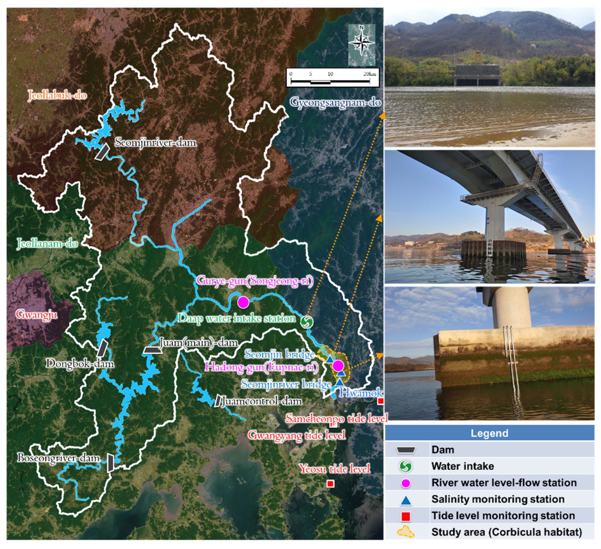
2.1. Study Area
2.2. EFDC Model Description
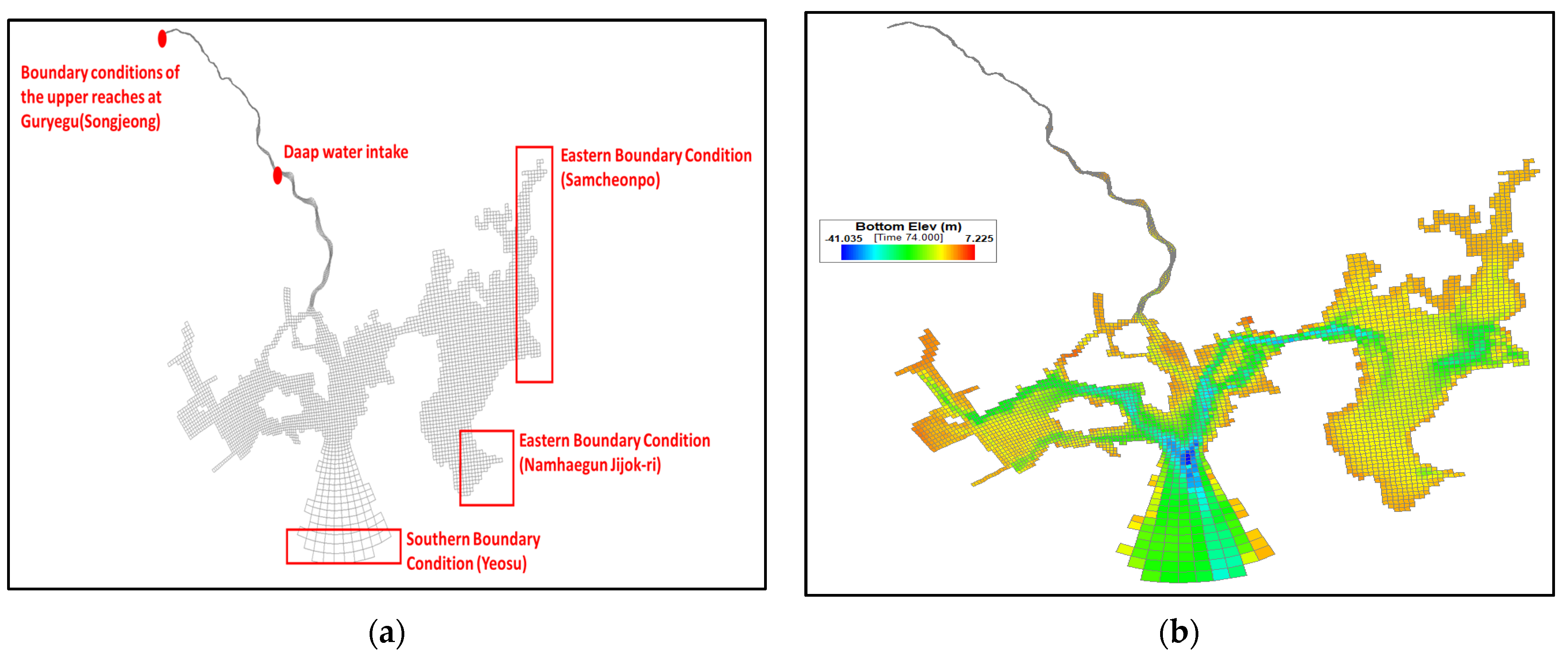
2.3. Data Setup for a Simulation Model
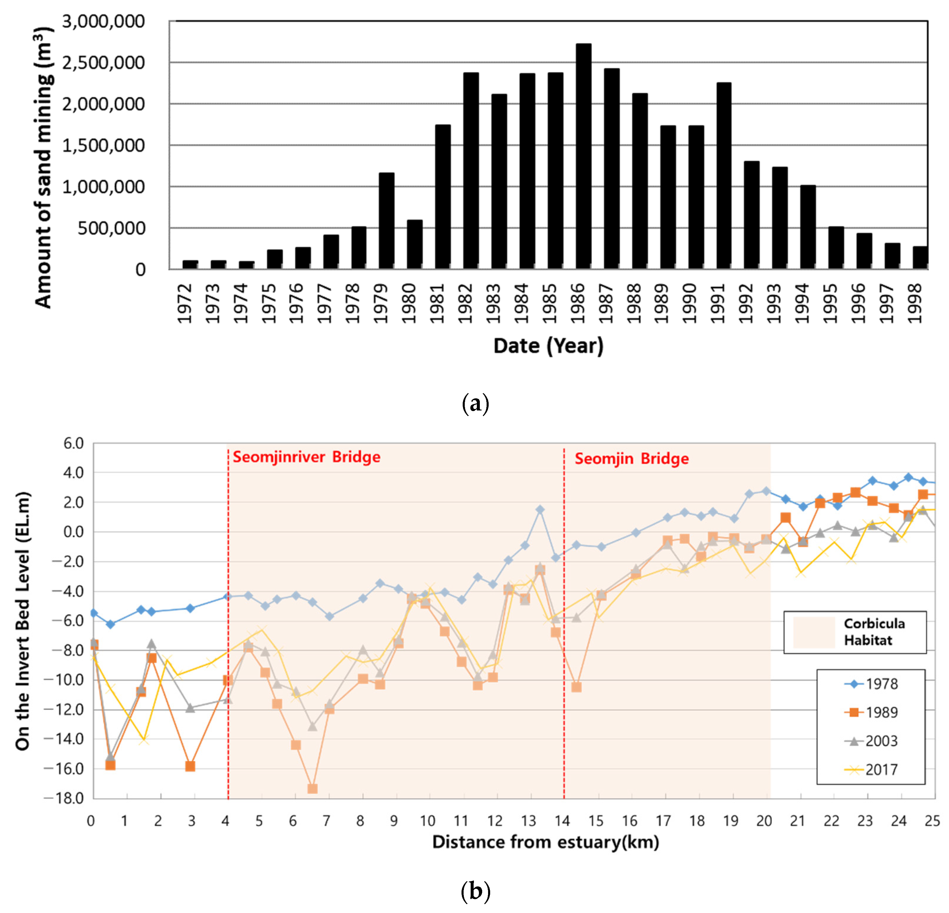
2.3.1. Environmental Changes at Daap Water Intake and Sand Mining Works
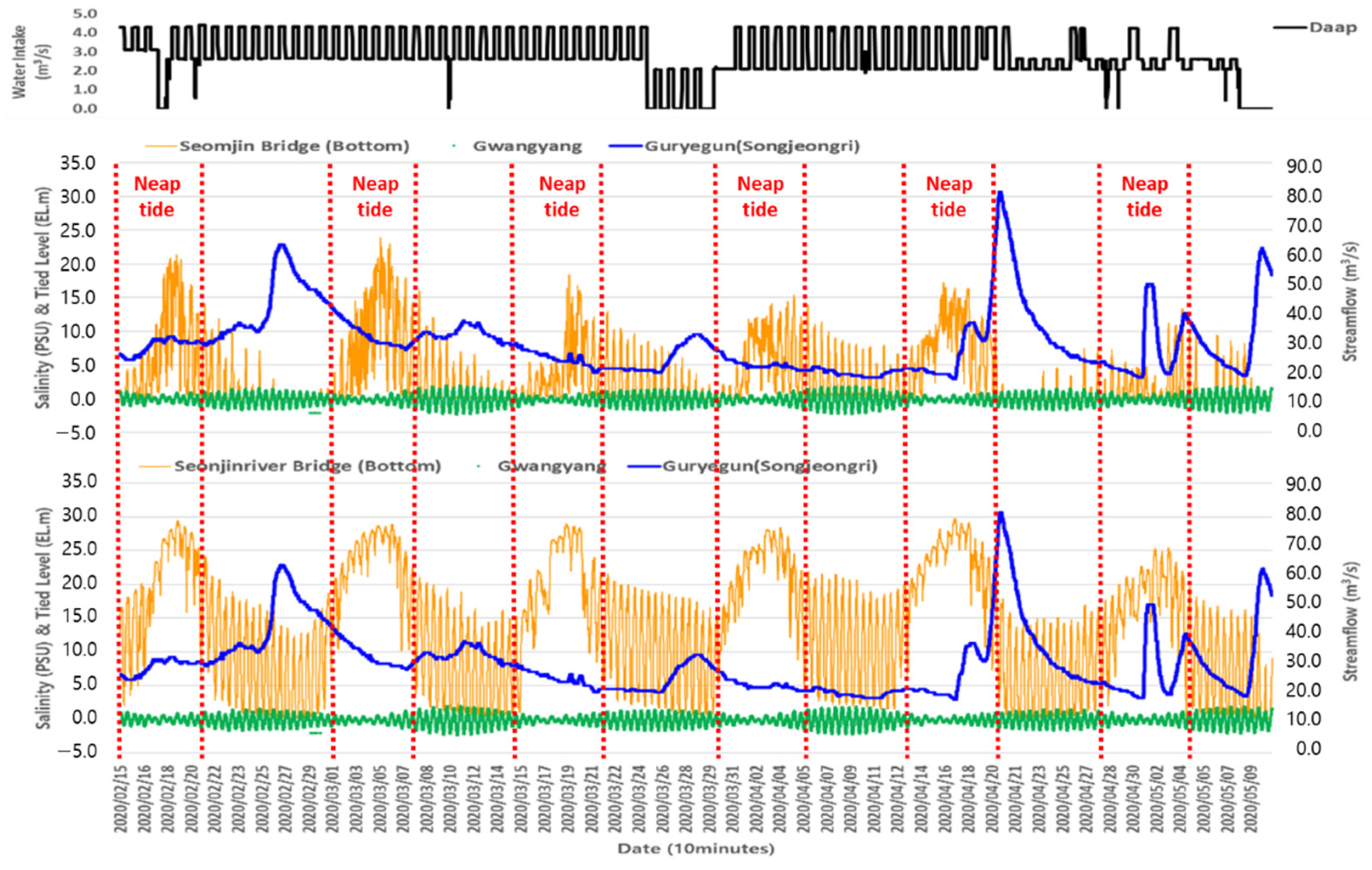
2.3.2. Measured Hydrological Data for Simulations of the EFDC Model
2.4. Model Application for Salinity Simulation
2.5. Ranges of Salinity for Habitable Environments of Corbicula
3. Results
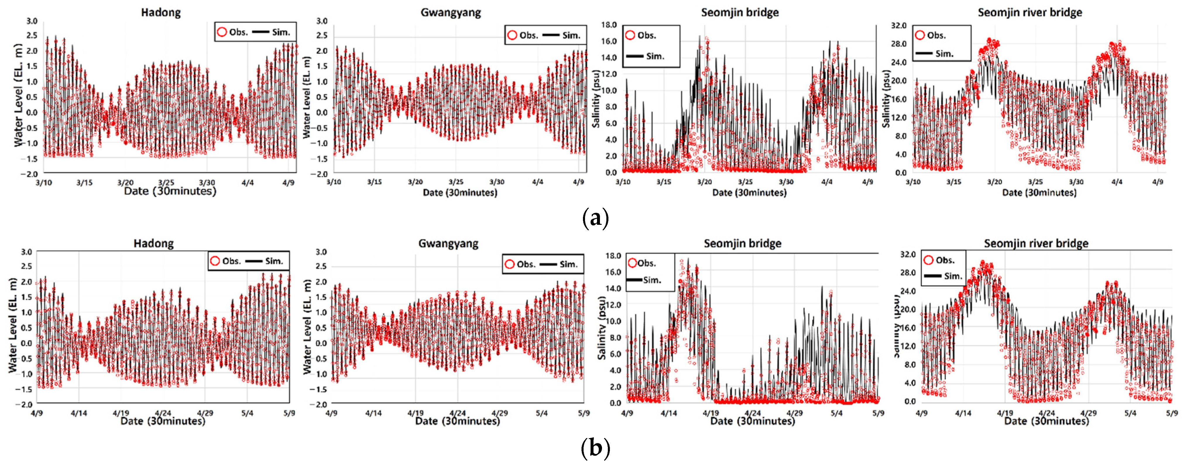
3.1. Model Calibration and Validation
3.2. Derivation of the Optimal Discharge for Habitable Corbicula Environments
3.3. Analysis of Salinity Reduction Effects under Various Scenarios
3.3.1. Riverbed Restoration
3.3.2. Submerged Weir
3.3.3. Groynes
3.3.4. Comprehensive Evaluation of Structural Scenarios
4. Discussion
- (1)
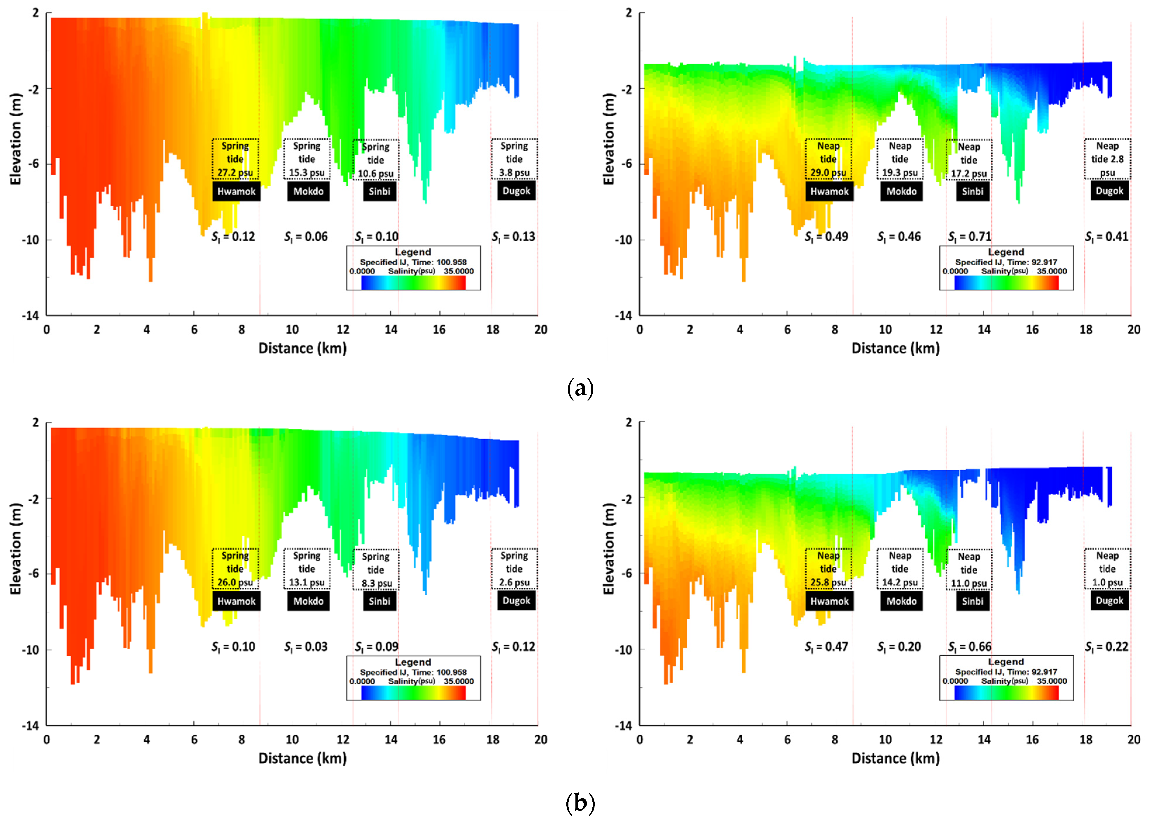
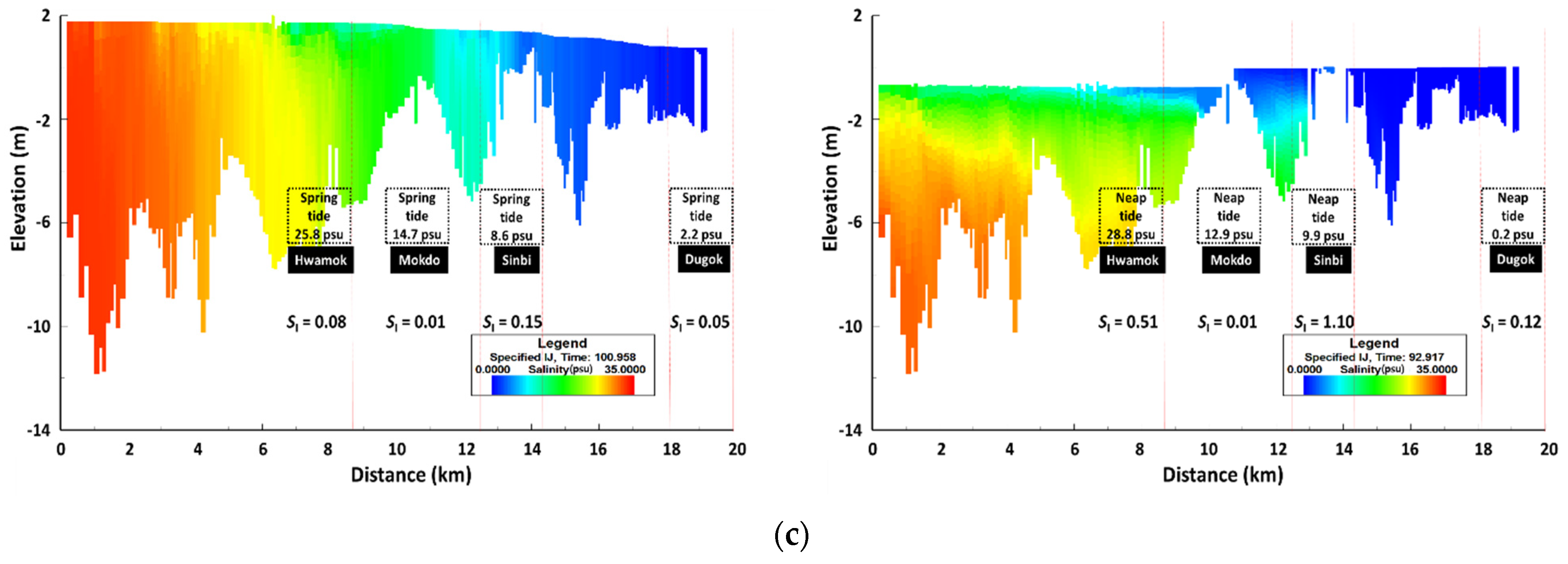
- The analysis of average salinity reduction effects enables the assessment of whether the structural scenarios applied as models fulfill the overall salinity concentration conditions suitable for corbicula growth by delaying or preventing natural seawater flow.
- (2)
- By analyzing the vertical distribution of salinity concentrations to investigate saltwater stratification during neap tides, it is possible to identify sections of the riverbed where corbicula growth is feasible despite an overall reduction in average salinity concentrations. This distinction is based on the salinity distribution in the riverbed where corbicula grows.
- (3)
- By analyzing the penetration distance of salinity concentrations into the riverbed, it is possible to evaluate the sections suitable for optimal corbicula habitat conditions, considering both the average salinity concentration and the high salinity stagnation phenomenon at the riverbed.
5. Conclusions
Author Contributions
Funding
Institutional Review Board Statement
Informed Consent Statement
Data Availability Statement
Conflicts of Interest
References
- Noh, J.; Lee, J.Y.; Shin, J.K. Analysis of saltwater intrusion by flushing discharge in the Seomjin River estuary. J. Environ. Impact Assess. 2011, 20, 325–335. [Google Scholar]
- Baek, S.H.; Seo, J.Y.; Choi, J.W. Growth characteristics and distribution pattern of a brackish water clam, Corbicula japonica along an estuarine salinity gradient in Seomjin River. J. Korea Acad.-Ind. Coop. Soc. 2015, 16, 6852–6859. [Google Scholar] [CrossRef]
- Son, Y.G. A Numerical Simulation for Salinity Intrusion in Nakdong River Estuary Using EFDC. Ph.D. Dissertation, Kongju University Graduate School, Kongju, Republic of Korea, 2009. (In Korean). [Google Scholar]
- Han, S.D. Evaluation of mean tidal currents at Kwangyang and Chinju Bay, Connected into Noryang Channel. Theses Collect. 1995, 13, 161–170. [Google Scholar]
- Lee, J.J.; Kim, Y.J. Analysis of flow duration characteristics due to environmental change in Korea River Basin. J. Korean Soc. Hazard Mitig. 2011, 11, 67–75. [Google Scholar] [CrossRef]
- Kang, S.; Choi, S.; Lee, D. Evaluation and re-estimation of instream flow considering the water quality and aquatic ecosystem of the Seomjingang River Watershed. J. Korean Soc. Hazard Mitig. 2021, 21, 347–355. [Google Scholar] [CrossRef]
- Minhas, P.S.; Ramos, T.B.; Ben-Gal, A.; Pereira, L.S. Coping with salinity in irrigated agriculture: Crop evapotranspiration and water management issues. Agric. Water Manag. 2020, 20, 105832. [Google Scholar] [CrossRef]
- Krishna, P.; Mina, D.; Meisam, R.; Roland, O. Managing salinity for sustainable agricultural production in salt-affected soils of irrigated drylands. Agric. Syst. 2022, 198, 103390. [Google Scholar] [CrossRef]
- Chun, J.A.; Lim, C.; Kim, D.; Kim, J.S. Assessing Impacts of Climate Change and Sea-Level Rise on Seawater Intrusion in a Coastal Aquifer. Water 2018, 10, 357. [Google Scholar] [CrossRef]
- Ministry of Land, Infrastructure and Transport. Seomjin River Basic Plan; Ministry of Land, Infrastructure and Transport: Seoul, Republic of Korea, 2021.
- Seo, J.Y.; Kim, J.H.; Choi, J.W. A comparative study on the ecological characters of Corbicula japonica populations inhabiting at the subtidal estuary of the Seomjin River and the intertidal eulsuk sand flat of the Nakdong River, Korea. Korean J. Malacol. 2018, 34, 135–146. [Google Scholar] [CrossRef]
- Song, C.G.; Kim, H.J.; Rhee, D.S. Analysis of flow reversal by tidal elevation and discharge conditions in a Tidal River. J. Korean Soc. Saf. 2014, 29, 104–110. [Google Scholar] [CrossRef]
- Kim, S. Research on Methodology of Hydrodynamic-Water Quality and Stratification Modeling in Reservoir Using EFDC. Ph.D. Dissertation, Chungnam University Graduate School, Daejeon, Republic of Korea, 2010. [Google Scholar]
- Shin, C.M.; Min, J.H.; Park, S.Y.; Choi, J.; Park, J.H.; Song, Y.S.; Kim, K. Operational water quality forecast for the Yeongsan River using EFDC model. J. Korean Soc. Water Environ. 2017, 33, 219–229. [Google Scholar]
- Moustafa, M.Z.; Ji, Z.G.; Hamrick, J. Impacts of freshwater sources on salinity structure in a large, shallow estuary. Environments 2024, 11, 72. [Google Scholar] [CrossRef]
- Jeong, S.M.; Yeon, K.S.; Hur, Y.T.; Oh, K.R. Salinity intrusion characteristics analysis using EFDC model in the downstream of Geum River. J. Environ. Sci. 2010, 22, 934–939. [Google Scholar] [CrossRef]
- Ceon, I.K.; Kim, M.H. The prediction and analysis of bed changes characteristics in the Seomjin River Downstream. J. Korean Soc. Hazard Mitig. 2009, 9, 115–121. [Google Scholar]
- Crone, T. The basic sediment transport equations made ridiculously simple. In Ocean/Ess 410 Marine Geology and Geophysics; Marine Sciences Building: Savannah, GA, USA, 2004. [Google Scholar]
- Lee, J.Y.; Kim, W.K.; Lee, C.S. Growth and survival of the brackish water clam, Corbicula japonica larvae according to rearing conditions. Korean J. Malacol. 2011, 27, 337–343. [Google Scholar] [CrossRef]
- Lee, M.H.; Choi, J.D.; Noh, G.H.; Shin, S.J.; Ryu, D.K. Distribution and biomass estimation of Corbicula japonica in the Seomjin River, Korea. Korean J. Malacol. 2021, 37, 17–24. [Google Scholar]
- Nakamura, M.; Aki, S.; Takahashi, F.; Shinagawa, A.; Nakao, S. Salt tolerance of yamato shijimi (Corbicula japonica). Aquaculture 1996, 44, 31–35. [Google Scholar]
- Japan Fisheries Agency. Guidelines for Improvement Techniques in Lakes and Ponds Fisheries; Japan Fisheries Agency: Tokyo, Japan, 2009.
- Seo, J.; Kim, J.; Chung, J.; Lee, Y.; Choi, J. Distribution patterns of a marsh clam, Corbicula japonica on the eulsuk tidal flat of the Nakdong River estuary, Korea. Korean J. Malacol. 2017, 33, 185–193. [Google Scholar] [CrossRef]
- Korea Institute of Ocean Science and Technology. Environmental Changes in the Seomjin River Estuary: Sedimentological-Geochemical Monitoring and Management Strategy; Korea Institute of Ocean Science and Technology: Busan, Republic of Korea, 2018. [Google Scholar]
- Lee, Y.; Choi, H.; Kim, W.; Cheong, C. Evaluation of acute toxicity of salinity, ammonia and nitrite to corbicula. J. Korean Soc. Environ. Technol. 2016, 17, 542–547. [Google Scholar]
- Moriasi, D.N.; Arnold, J.G.; Van Liew, M.W.; Bingner, R.L.; Harmel, R.D.; Veith, T.L. Model evaluation guidelines for systematic quantification of accuracy in watershed simulations. Trans. ASABE 2007, 50, 885–900. [Google Scholar] [CrossRef]
- Shaha, D.; Cho, Y. Comparison of empirical models with intensively observed data for prediction of salt intrusion in the Sumjin River estuary, Korea. Hydrol. Earth Syst. Sci. 2009, 13, 923–933. [Google Scholar] [CrossRef]
- Michor, K.; Senfter, S.; Nemmert, A.; Unterlercher, M.; Reisinger, M. River Restoration Concept Based on Calculations of Optimal River Width; Euronatur, RIZA Rapport; Institute for Inland Water Management and Waste Water Treatment: Lelystad, The Netherlands, 2021. [Google Scholar] [CrossRef]
- Krishna, P.D.; Mina, D.; Meisam, R.; Roland, O. Human-induced salinity changes impact marine organisms and ecosystems. Glob. Change Biol. 2023, 29, 4731–4749. [Google Scholar] [CrossRef]

| Daap Intake (m3/s) | Discharge at Gurye-gun (Songjeong-ri) (m3/s) | Model Simulated Result (psu) | |||||
|---|---|---|---|---|---|---|---|
| Seomjin Bridge | Seomjin River Bridge | Hwamok | |||||
| Spring Tide | Neap Tide | Spring Tide | Neap Tide | Spring Tide | Neap Tide | ||
| 2.523 | 5 | 16.45 | 19.94 | 21.79 | 25.70 | 26.38 | 27.94 |
| 10 | 12.64 | 19.12 | 18.76 | 25.52 | 24.50 | 27.60 | |
| 15 | 7.98 | 18.01 | 15.68 | 24.96 | 22.20 | 27.16 | |
| 20 | 3.60 | 16.75 | 12.88 | 24.54 | 20.34 | 25.98 | |
| 25 | 2.17 | 15.52 | 11.62 | 23.99 | 19.22 | 26.29 | |
| 30 | 1.46 | 14.33 | 10.41 | 23.49 | 18.25 | 25.98 | |
| 35 | 0.98 | 13.16 | 9.98 | 23.01 | 17.94 | 25.74 | |
| 3.125 | 5 | 16.83 | 20.07 | 22.03 | 25.75 | 26.44 | 27.94 |
| 10 | 13.13 | 19.29 | 19.15 | 25.54 | 24.69 | 27.61 | |
| 15 | 8.44 | 18.10 | 16.04 | 25.12 | 22.32 | 27.22 | |
| 20 | 3.77 | 16.91 | 12.89 | 24.69 | 20.38 | 26.02 | |
| 25 | 2.25 | 15.65 | 11.82 | 24.05 | 19.29 | 26.29 | |
| 30 | 1.48 | 14.44 | 10.51 | 23.61 | 18.29 | 26.02 | |
| 35 | 1.01 | 13.32 | 10.23 | 23.10 | 18.02 | 25.80 | |
| 3.912 | 5 | 17.32 | 20.09 | 22.47 | 25.81 | 26.68 | 27.96 |
| 10 | 13.45 | 19.37 | 19.48 | 25.58 | 24.74 | 27.66 | |
| 15 | 9.22 | 18.34 | 16.48 | 25.21 | 22.61 | 27.28 | |
| 20 | 4.22 | 17.15 | 13.37 | 24.77 | 20.60 | 26.32 | |
| 25 | 2.39 | 15.84 | 11.90 | 24.17 | 19.29 | 26.37 | |
| 30 | 1.60 | 14.82 | 10.89 | 23.95 | 18.65 | 26.32 | |
| 35 | 1.07 | 13.53 | 10.29 | 23.30 | 18.05 | 25.89 | |
| 4.630 | 5 | 17.83 | 20.19 | 22.85 | 25.89 | 26.84 | 28.04 |
| 10 | 14.13 | 19.58 | 19.89 | 25.67 | 24.90 | 27.68 | |
| 15 | 9.57 | 18.54 | 16.89 | 25.32 | 22.74 | 27.34 | |
| 20 | 4.34 | 17.36 | 13.52 | 24.88 | 20.71 | 26.11 | |
| 25 | 2.43 | 16.03 | 12.03 | 24.30 | 19.29 | 26.43 | |
| 30 | 1.60 | 14.82 | 10.65 | 23.78 | 18.45 | 26.11 | |
| 35 | 1.12 | 13.72 | 10.47 | 23.35 | 18.18 | 25.92 | |
| Scenarios | Description | Model Application | Application Map |
|---|---|---|---|
| Riverbed Restoration | A method of raising the downstream water level by uniformly elevating the existing riverbed throughout the 1 to 17 km stretch from the Seomjin River estuary, achieved through activities such as sand mining. | For EFDC grid (i, j) Grids 63–69 and 70–215: Increasing the existing downstream water level values by ① 1 m, ② 2 m, and ③ 3 m |  |
| Submerged Weir | The installation of three underwater dams between the 1 to 6 km stretch from the Seomjin River estuary, designed to maintain a constant water level or slow the water flow. | For EFDC grid (i, j) ① Grids 63–69 and 71: An increase of 2 m, 3 m, and 4 m from the existing downstream water level values. ② Grids 63–69 and 87: An increase of 2 m, 3 m, and 4 m from the existing downstream water level values. ③ Grids 63–69 and 98: An increase of 2 m, 3 m, and 4 m from the existing downstream water level values. | 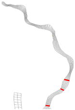 |
| Groynes | To prevent the flow, four weirs are installed within the river channel, positioned between the 4 and 6 km stretch from the Seomjin River estuary. | For EFDC grid (i, j): ① Grids 63–66 and 90: Implementing a method to raise the existing downstream water level values by 1 m, 2 m, and 3 m. ② Grids 66–69 and 92: Implementing a method to raise the existing downstream water level values by 1 m, 2 m, and 3 m. ③ Grids 63–66 and 94: Implementing a method to raise the existing downstream water level values by 1 m, 2 m, and 3 m. ④ Grids 66–69 and 96: Implementing a method to raise the existing downstream water level values by 1 m, 2 m, and 3 m. | 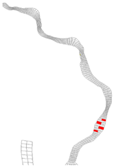 |
| Scenarios | Discharge at Gurye-gun (Songjeong-ri) (m3/s) | Water Intake at Daap (m3/s) | Riverbed Restoration (m) | Average Salinity (psu), Salinity Reduction (psu, RRS-0 Minus Each Scenarios) | |||
|---|---|---|---|---|---|---|---|
| Dugok (Spring/Neap Tides) | Sinbi (Spring/Neap Tides) | Mokdo (Spring/Neap Tides) | Hwamok (Spring/Neap Tides) | ||||
| RRS-0 | 10 | 3.912 | 0 | 6.6/9.1, - | 15.2/22.9, - | 19.2/24.4, - | 28.6/29.4, - |
| RRS-1 | 1 | 3.8/2.8, −2.8/−6.3 | 10.6/17.2, −4.6/−5.7 | 15.3/19.3, −3.9/−5.1 | 27.2/29.0, −1.4/−0.4 | ||
| RRS-2 | 2 | 2.6/1.0, −4.0/−8.1 | 8.3/11.0, −6.9/−11.9 | 13.1/14.2, −6.1/−10.2 | 26.0/28.5, −2.6/−0.9 | ||
| RRS-3 | 3 | 2.2/0.2, −4.4/−8.9 | 8.6/9.9, −6.6/−13.0 | 14.7/12.9, −4.5/−11.5 | 25.8/28.8, −2.8/−0.6 | ||
| Scenarios | Discharge at Gurye-gun (Songjeong-ri) (m3/s) | Water Intake at Daap (m3/s) | Submerged Weir Height (m) | Salinity (psu), Salinity Reduction (psu, RRS-0 Minus Each Scenarios) | |||
|---|---|---|---|---|---|---|---|
| Dugok (Spring/Neap Tides) | Sinbi (Spring/Neap Tides) | Mokdo (Spring/Neap Tides) | Hwamok (Spring/Neap Tides) | ||||
| SWS-0 | 10 | 3.912 | 0 | 6.6/9.1, - | 15.2/22.9, - | 19.2/24.4, - | 28.6/29.4, - |
| SWS-1 | 2 | 6.6/9.1, −0.0/−0.0 | 15.2/22.8, −0.0/−0.1 | 19.2/24.4, −0.0/−0.0 | 28.6/29.4, −0.0/−0.0 | ||
| SWS-2 | 3 | 6.6/9.1, −0.0/−0.0 | 15.2/22.8, −0.0/−0.1 | 19.1/24.4, −0.1/−0.0 | 28.5/29.3, −0.1/−0.1 | ||
| SWS-3 | 4 | 6.6/9.0, −0.0/−0.1 | 15.1/22.7, −0.1/−0.2 | 19.1/24.2, −0.1/−0.2 | 28.5/29.3, −0.1/−0.1 | ||
| Scenarios | Discharge at Gurye-gun (Songjeong-ri) (m3/s) | Water Intake at Daap (m3/s) | Groynes Height (m) | Salinity (psu), Salinity Reduction (psu, RRS-0 Minus Each Scenarios) | |||
|---|---|---|---|---|---|---|---|
| Dugok (Spring/Neap Tides) | Sinbi (Spring/Neap Tides) | Mokdo (Spring/Neap Tides) | Hwamok (Spring/Neap Tides) | ||||
| GS-0 | 10 | 3.912 | 0 | 6.6/9.1, - | 15.2/22.9, - | 19.2/24.4, - | 28.6/29.4, - |
| GS-1 | 1 | 6.5/8.9, −0.1/−0.2 | 15.0/22.6, −0.2/−0.3 | 19.0/24.2, −0.2/−0.2 | 28.4/29.4, −0.2/−0.0 | ||
| GS-2 | 2 | 6.4/8.7, −0.2/−0.4 | 14.8/22.2, −0.4/−0.7 | 18.7/23.8, −0.5/−0.6 | 28.1/29.4, −0.5/−0.1 | ||
| GS-3 | 3 | 6.2/8.3, −0.4/−0.8 | 15.1/22.7, −0.1/−0.2 | 18.4/23.1, −0.8/−1.3 | 27.7/29.3, −0.9/−0.1 | ||
| Scenarios | Discharge at Gurye-gun (Songjeong-ri) (m3/s) | Water Intake at Daap (m3/s) | Height (m) | Salinity (psu), Salinity Reduction (psu, RRS-0 Minus Each Scenarios) | |||
|---|---|---|---|---|---|---|---|
| Dugok (Spring/Neap tides) | Sinbi (Spring/Neap Tides) | Mokdo (Spring/Neap Tides) | Hwamok (Spring/Neap Tides) | ||||
| No | 10 | 3.912 | 0 | 6.6/9.1, - | 15.2/22.9, - | 19.2/24.4, - | 28.6/29.4, - |
| All | Riverbed restoration 3 m+ Submerged Weir 4 m + Groyne 3 m | 2.0/0.1, −4.6/−9.0 | 8.5/9.5, −6.7/−13.4 | 14.1/11.1, −5.1/−13.3 | 25.5/28.5, −3.4/−0.9 | ||
| Scenarios | Height (m) | Salinity (15 psu) Intrusion Distance (km) | Salinity (20 psu) Intrusion Distance (km) | Salinity (25 psu) Intrusion Distance (km) |
|---|---|---|---|---|
| No | - | 17.9 | 15.9 | 13.1 |
| Riverbed restoration | 3 m | 14.5 (−3.4) | 12.0 (−3.9) | 9.6 (−3.5) |
| Submerged Weir | 4 m | 17.9 (−0.0) | 15.9 (−0.0) | 13.0 (−0.1) |
| Groyne | 3 m | 17.7 (−0.2) | 15.8 (−0.1) | 12.7 (−0.4) |
| All | Riverbed restoration 3 m + Submerged Weir 4 m + Groyne 3 m | 14.2 (−3.7) | 11.9 (−4.0) | 9.5 (−3.6) |
Disclaimer/Publisher’s Note: The statements, opinions and data contained in all publications are solely those of the individual author(s) and contributor(s) and not of MDPI and/or the editor(s). MDPI and/or the editor(s) disclaim responsibility for any injury to people or property resulting from any ideas, methods, instructions or products referred to in the content. |
© 2024 by the authors. Licensee MDPI, Basel, Switzerland. This article is an open access article distributed under the terms and conditions of the Creative Commons Attribution (CC BY) license (https://creativecommons.org/licenses/by/4.0/).
Share and Cite
Lee, G.; Park, J.; Jung, C.; An, Y. Assessing Salinity Reduction by Environmental Restoration in the Seomjin River Estuary (South Korea): A Numerical Model Approach for Corbicula Habitat Conservation. Sustainability 2024, 16, 5653. https://doi.org/10.3390/su16135653
Lee G, Park J, Jung C, An Y. Assessing Salinity Reduction by Environmental Restoration in the Seomjin River Estuary (South Korea): A Numerical Model Approach for Corbicula Habitat Conservation. Sustainability. 2024; 16(13):5653. https://doi.org/10.3390/su16135653
Chicago/Turabian StyleLee, Gayeong, Jongyoon Park, Chunggil Jung, and Yunkeun An. 2024. "Assessing Salinity Reduction by Environmental Restoration in the Seomjin River Estuary (South Korea): A Numerical Model Approach for Corbicula Habitat Conservation" Sustainability 16, no. 13: 5653. https://doi.org/10.3390/su16135653