Abstract
Understanding and managing land use/cover changes (LUCC) is crucial for ensuring the sustainability of the region. With the support of remote sensing technology, intensity analysis, the geodetic detector model, and the Mixed-Cell Cellular Automata (MCCA) model, this paper constructs an integrated framework linking historical evolutionary pattern-driving mechanisms for future simulation for LUCC in the Lower Liaohe Plain. From 1980 to 2018, the increasing trends were in built-up land and water bodies, and the decreasing trends were in grassland, cropland, forest land, unused land, and swamps. Overall, the changes in cropland, forest land, and built-up land are more active, while the changes in water bodies are more stable; the sources and directions of land use conversion are more fixed. Land use changes in the Lower Liaohe Plain are mainly influenced by socio-economic factors, of which population density, primary industry output value, and Gross Domestic Product (GDP) have a higher explanatory power. The interactive influence of each factor is greater than any single factor. The results of the MCCA model showed high accuracy, with an overall accuracy of 0.8242, relative entropy (RE) of 0.1846, and mixed-cell figure of merit (mcFoM) of 0.1204. By 2035, the built-up land and water bodies will increase, while the rest of the land use categories will decrease. The decrease is more pronounced in the central part of the plains. The findings of the study provide a scientific basis for strategically allocating regional land resources, which has significant implications for land use research in similar regions.
1. Introduction
Since the 1980s, the significance of LUCC has been on the rise in comprehending global environmental change and the interconnectedness between social and environmental systems [1,2,3,4]. Alterations in land use and land cover (LULC) serve as visible evidence of the profound influence of human activities on the structure of the Earth’s surface, forming a critical focal point in the study of global environmental change and sustainable development. They are imperative for advancing various objectives outlined in the United Nations Sustainable Development Goals (SDGs), including but not limited to SDGs 3, 9, and 15 [5,6]. Against the backdrop of rapid global economic growth and accelerating urbanization, land use has led to various ecological issues, including carbon emissions [7,8], climate change [9,10], loss of biodiversity [11], a decline in ecosystem productivity [12], soil and land degradation [13], and a weakening of ecosystem services [14], directly impacting the region’s capacity for sustainable development. Therefore, studying the process of LUCC, uncovering the reasons for changes in land resources, and predicting future trends in land cover types can guide human land use activities to ensure that land use changes benefit global environmental sustainability, ultimately achieving sustainable development [15].
Since the implementation of the “LUCC Scientific Research Program” in 1995, numerous scholars have undertaken thorough investigations into the spatiotemporal evolution patterns of LUCC [16,17], analyses of the driving factors [18], and simulation predictions in this field [16].
When analyzing changes in LUCC types, models such as the land use transfer matrix [9,19], land use dynamic models, land use degree comprehensive index models, and landscape pattern indices are widely utilized [20,21]. These models offer valuable insights into the overall changes in regional LUCC from various perspectives. For example, the land use transfer matrix is primarily utilized to comprehensively analyze the quantitative characteristics of regional land use and land cover changes (LUCCs) and the directions of the changes within each category [22]. Land use dynamic models can delve into the spatial changes in land use and the alterations in the composition of land use types [23]. However, an increasing number of scientists believe that the intensity (proportion) of change may hold more value than the size of the change in understanding the processes of land use and land cover (LULC) changes [24]. Aldwaik introduced a new analytical framework called intensity analysis to depict land use change patterns [25]. This method, utilizing the land use transfer matrix, scrutinizes the extent and intensity of land use alterations from a higher-level approach at the interval, category, and transfer levels. Furthermore, the method identifies the stability features of regional land use transformations through consecutive time intervals [26].
Quantitatively analyzing the driving factors and predicting future changes are the current focus and challenges of the research [27], and are crucial for achieving sustainable land use and mitigating global environmental issues [28]. Globally, the driving forces causing changes in land use types mainly stem from natural systems and social systems (including societal, economic, and policy dimensions). In the long term, natural factors in more ecologically sensitive areas have a controlling effect on LUCC [29], including vegetation type, soil, and precipitation. For example, in the studies by Li et al. [30] and Zhang et al. [31], natural conditions are the main factors affecting LUCC. On the other hand, social factors play a more significant role in the short term, with economic development and population size becoming the dominant factors of LUCC, as evidenced in the studies by Zhou et al. [32], Ning et al. [33], and Wei et al. [34]. Currently, the analysis of driving mechanisms is transitioning from qualitative studies to empirical statistical methods, commonly including correlation analyses, logistic regression models, principal component analyses, geographic weighted regression, and geodetector methods [30,35]. One commonly utilized tool for quantitatively analyzing the driving forces of spatial heterogeneity in geographic factors is the geodetector. It is favored due to its applicability, solid theoretical basis, and user-friendly operation [27].
The simulation of LUCC has evolved from quantitative to spatial pattern simulations, and from single models to coupled models, showing a trend towards multiple models, techniques, and forms of intelligence. The main LUCC simulation models at this stage include Cellular Automaton (CA), the Markov Model [36], System Dynamics (SD), the Conversion of Land Use and its Effects to a Small regional extent (CLUE-S) [37], Agent-Based Models (ABMs), Future Land Use Simulation (FLUS), etc. [38,39,40]. Although these traditional models have produced the expected simulation results, they also possess certain limitations. For instance, the SD model can illustrate the interactions between the structure, function, and dynamic behavior of complex systems. However, it struggles to manage spatial information and lacks the capacity to depict the spatial pattern of land use [41]. The FLUS model is capable of simulating jumping land use changes, yet it faces challenges in accurately portraying spatial discrepancies in land use alterations across various regions [42]. CA can be seamlessly integrated with other models, GIS, and remote sensing data to enhance its simulation capabilities. It boasts robust spatial computing capabilities, although its conversion rules often depend on empirical statistics or expert knowledge [43]. To further CA models’ ability to mine land use change patterns, Xun Liang et al. proposed the MCCA (Mixed-Cell Cellular Automata) model in 2021, which utilizes a mixed metacell that incorporates various land use types, adapting to the intricate land use conditions. Compared to traditional CA models, the MCCA model exhibits differences in cell space, cell state, and cell neighborhood transformation rules, achieving a breakthrough from qualitative, static simulations to quantitative, dynamic simulations [44].
The Lower Liaohe River Plain, a pivotal area for land resource development, has evolved into a region characterized by diverse landscape types through the interaction of natural processes and human activities over time [45]. For instance, the Liaohe Estuary National Natural Wetland Reserve is situated within this area. Meanwhile, the Lower Liaohe Plain holds significance as one of the key national grain production centers. Recently, noticeable changes have been observed in the Lower Liaohe Plain in response to factors such as global population expansion, rapid urbanization trends, climate change, and frequent episodes of natural disasters [46]. The reduction in forest and grassland areas, along with wetland degradation and other ecological concerns, has emerged as a challenge impacting the development of the central urban cluster in Liaoning Province and the Shenyang economic zone. These challenges also pose a threat to the sustainable development of the regional ecological environment. Understanding the drivers behind these land cover changes and forecasting future trends are pivotal for discerning the ecological impacts in similar regions.
Therefore, in this study, the intensity analysis, geodetector model and MCCA model were selected to analyze the LUCC characteristics, driving mechanisms, and future development trends of the Lower Liaohe Plain. This paper aims to achieve the following research objectives: (1) analyze the evolving patterns of different land use types in the Lower Liaohe region from 1980 to 2018; (2) investigate the driving forces behind LUCC, considering natural, social, and economic factors; (3) simulate the changing patterns and future trends of LUCC in the Lower Liaohe Plain from 2018 to 2035. It is anticipated that this study will furnish a scientific foundation for optimizing the land use structure, enhancing the efficiency of land resource utilization, and promoting sustainable development. Additionally, it aims to offer historical insights and serve as a point of reference for future land use planning and policymaking.
2. Materials and Methods
2.1. Study Area
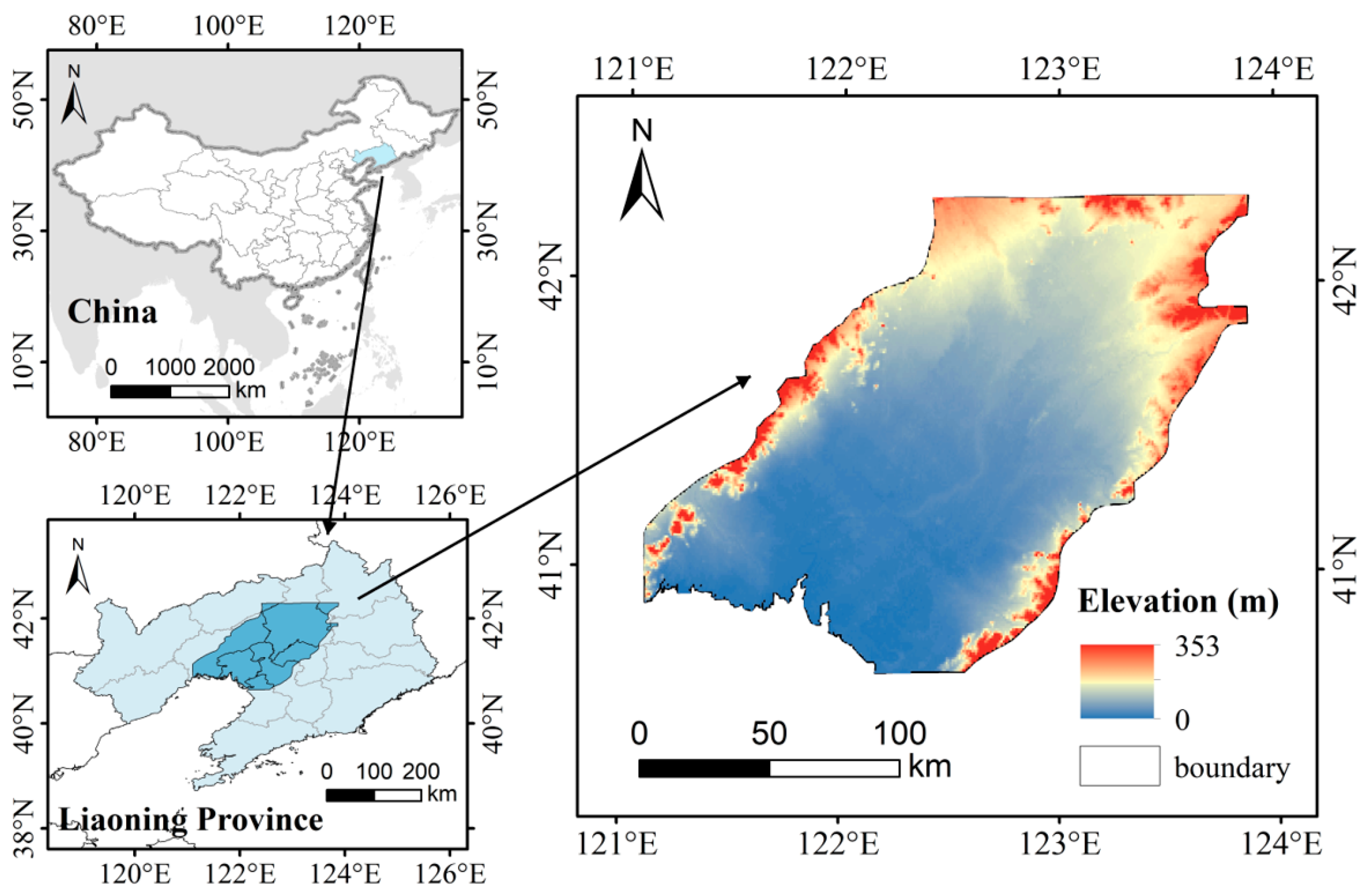
The Lower Liaohe River Plain, situated in the southern region of northeast China within central Liaoning Province, covers an area of around 35 × 104 km2. Spanning from 120°42′ E to 124°45′ E in longitude and 40°43′ N to 43°27′ N in latitude. The plain features a relatively low and flat, gently rising towards the east and west while sloping from north to south, with elevations below 50 m. The climate exhibits cold and dry winters and hot and humid rainy summers. The study area typically experiences concentrated precipitation between June to September each year, with annual levels ranging from 600 to 1100 mm.
The Lower Liaohe Plain serves as the primary agricultural production area in Northeast China, the core of the old industrial base, and the largest regionally integrated economic zone. This vast area covers 9 cities and 22 counties in Liaoning Province, with major municipalities including Shenyang City, Tieling City, Anshan City, Yingkou City, Panjin City, Fuxin City, Jinzhou City, Liaoyang City, and Fushun City (Figure 1).

Figure 1.
Location of the study area.
2.2. Data Sources and Preprocessing
Land use data (30 m) in 1980, 1990, 2000, 2010 and 2018 were selected, all from the United States Address Survey (USGS, https://earthexplorer.usgs.gov/) (accessed on 10 October 2021) (Table 1). Each image was imaged in July–August, and then the remote sensing images were radiometrically calibrated, atmospherically corrected, mosaicked, and cropped with the help of ENVI 5.5 software, and the images were classified by human–computer interaction visual interpretation and supervised classification. The image classification process utilized the remote sensing land use classification system from the “China Land Resources and Environment Database”. Considering the research requirements and the actual land use scenarios, the land in the study area was categorized into seven main types: grassland, built-up land, cropland, forest land, water bodies, unused land, and swamps. The classification results were validated through human–computer interaction, using random sampling from Google Earth. The overall accuracy achieved was 0.83, meeting the minimum acceptable discrimination accuracy threshold of Kappa ≥ 0.70 in validation results.

Table 1.
Description of Landsat image used in land use classification.
The Digital Elevation Model (DEM) data were obtained from the Geospatial Data Cloud (https://www.gscloud.cn, accessed on 3 August 2022). Data on average daily temperature, maximum/minimum temperature, sunshine hours, average daily wind speed at 10 m above ground level, and relative humidity were gathered from 25 meteorological stations to compute the standardized precipitation evapotranspiration index on a 12-month time scale (SPEI-12) and Reference Evapotranspiration (ET0) [47]. These data were sourced from the Natural Weather Information Center (http://data.cma.cn, accessed on 12 September 2022). Socioeconomic data such as population density, GDP, and primary industry output were obtained from the Liaoning Provincial Bureau of Statistics (https://tjj.ln.gov.cn/, accessed on 7 November 2022). Meteorological and socio-economic data span the period from 1980 to 2018.
2.3. Methods
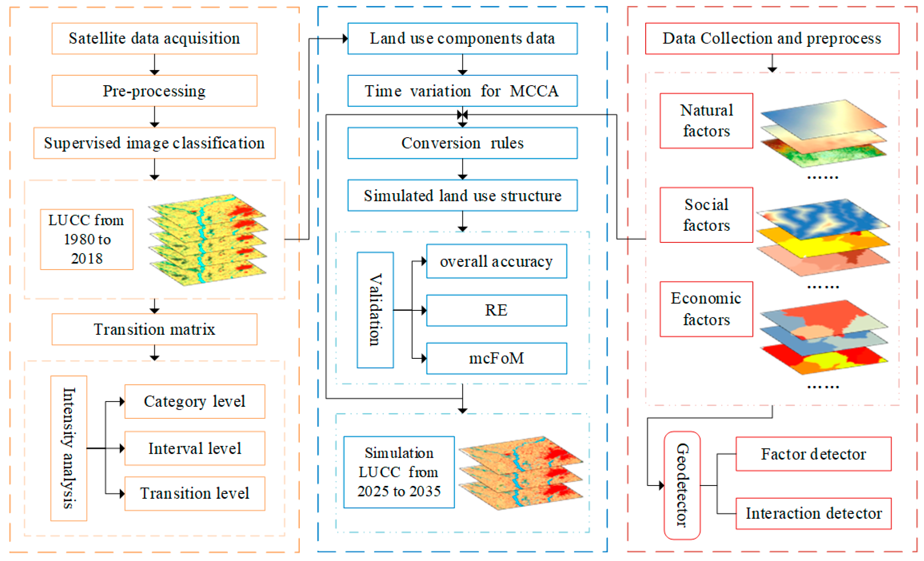
This paper’s technical approach includes three sections: analyzing LUCC characteristics, determining the driving mechanisms, and predicting future land use trends (Figure 2).
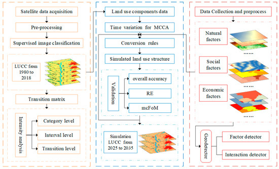
Figure 2.
The overall research framework.
2.3.1. Intensity Analysis
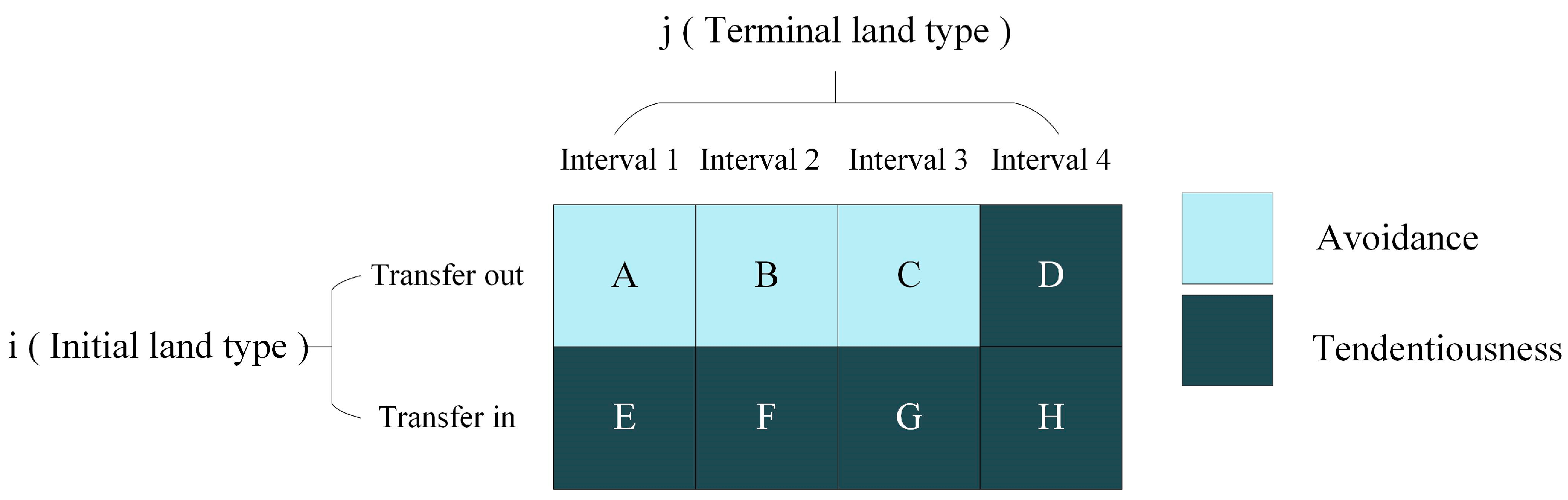
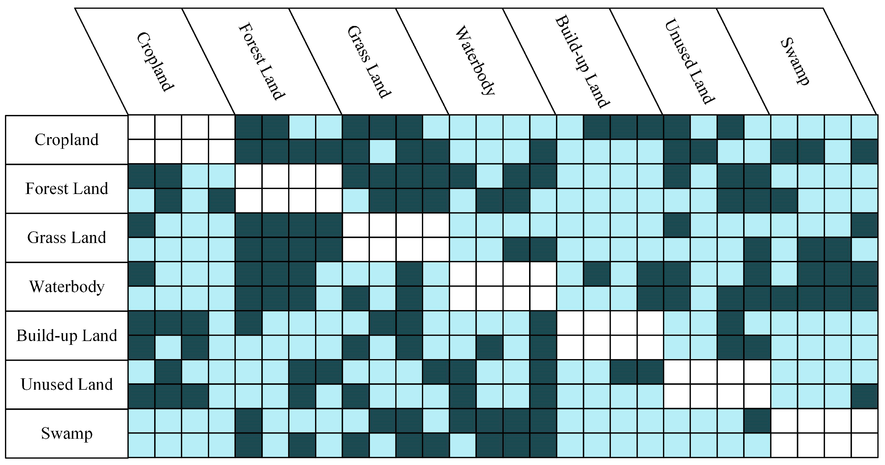
Utilizing the land use transfer matrix, this method quantitatively analyzes the transfer rates and directions of different land use types across various periods from different perspectives. The analysis is categorized into interval, category, and transformation levels [25]. The intensity analysis package can be accessed at https://sites.google.com/site/intensity analysis (accessed on 25 October 2022). To visually examine the changes in various land classes at the transformation level, this paper introduces a cross-linked table illustrating land conversion patterns (Figure 3) based on Yang’ study [48]. Letters A–E represent the transformational characteristics (tendency or avoidance) of the terrestrial species in each time interval, with colors indicating whether land class i tends to convert to land class j. Dark blue signifies a tendency to convert, while light blue indicates avoidance. When A and E share the same color in the vertical row, it indicates that the conversion from initial to final land class in time interval 1 has systematic characteristics (tendency or avoidance). Similarly, if A–D or E–H in the horizontal row match in color, it indicates stable conversion from initial to final land class Moreover, if all cells are of the same color, it indicates that the conversion between two land classes shows stable systematic changes.
where St represents the annual uniform intensity of LUCC; U represents the annual mean intensity of change in all time periods. Gtj represents the annual gain intensity of LULC type j; Lti represents the annual loss intensity of LULC type i. J represents the number of ground classes; i represents a certain ground class at the starting point; j represents a certain ground class at the end point; t represents the beginning time; Yt represents the year at time point t.

Figure 3.
Confusion table of land transition patterns.
2.3.2. Geodetector
The geodetector method is utilized to investigate spatial heterogeneity, comprising four components: factor detection, risk detection, interaction detection, and ecological detection. Factor detection assesses the explanatory power of various drivers, while interaction detection identifies how different drivers interact, comparing them with a value of q to determine whether the interaction of the two factors enhances or diminishes the impact on the dependent variable. Ecological detection explores the appropriate range of effects of different factors on the independent variable. Risk detection determines whether significant differences exist in attribute means between two sub-regions [49].
In this study, factor detection and interaction detection were selected for analyzing driving mechanisms. The formula for factor detection is as follows:
where h represents the stratification of the variable Y or factor X; Nh and N represents the number of cells in layer h and the full zone; δh2 and δ2 represents the variance of Y values in layer h and the full zone, respectively. The value of q ranges from 0 to 1, a value closer to 1 reflects a greater degree of influence, while a lower value suggests the opposite.
2.3.3. MCCA Model
The model operation mechanism comprises three parts [44].
- (1)
- Based on the dataset of land use and the driving factors from the initial and target years, the Random Forest Regression (RFR) algorithm is used to mine the land use conversion rules. The formula is as follows:
- (2)
- Based on the linear regression tool provided by the model, historical land use and future land use demand are obtained for model validation and future forecasting, respectively. Combining the input land use data, land use conversion probabilities, and domain boundaries, the proportion of coverage of each land use type in the mixed tuple cell is determined by the competitive roulette mechanism. The formula is as follows:
- (3)
- The overall accuracy, RE and mcFoM metrics are employed for assessing the model’s accuracy.
3. Results
3.1. Intensity Analysis of LUCC
3.1.1. Intensity Analysis of LUCC at Interval Level
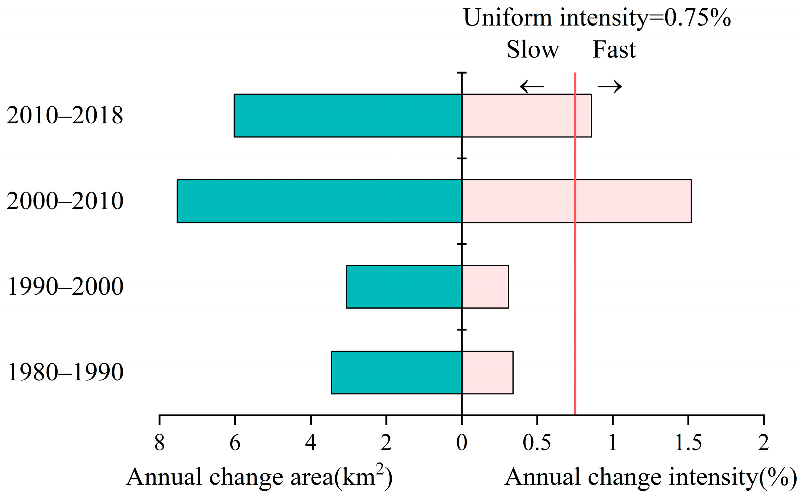
The intensity analysis results for the Lower Liaohe River Plain within the time interval are given in Figure 4. The left area indicates the amount of land use change during the time interval, while the right area shows the intensity of change (St) in each land category within those intervals. The red solid line represents the average intensity of change (U) over the study period. If a bar within a period exceeds the average intensity line (U = 0.75%), the land use change process within that period is faster; otherwise, it is slower. The land use area change in the Lower Liaohe River Plain was relatively small between 1980 and 2000, and relatively large between 2000 and 2018. The annual average intensity during 1980–2000 was 0.34% and 0.31%, respectively, neither of which exceeds the average intensity line, indicating slow change. However, the St during 2000–2018 exceeded the average change intensity line, especially reaching the maximum value (St = 1.52%) during 2000–2010, showing rapid changes. In general, land use and land cover change in the Lower Liaohe River Plain have shown a steadily acceleration over the past four decades.
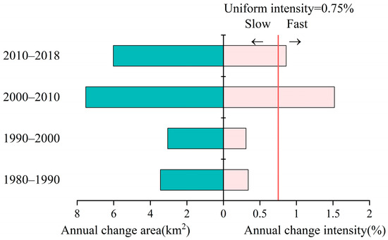
Figure 4.
Time Interval Level Intensity Analysis.
3.1.2. Intensity Analysis of LUCC at Category Level
The results of land use category levels are given in Figure 5. The transformation of land types became increasingly intricate over the study period, with the most significant changes observed in cropland. Cropland expansion was more pronounced before 2000, while a decrease in arable land became more prominent after 2000. Additionally, built-up land areas also exhibited significant changes, with the transferred-in area being consistently larger than the transferred-out area during the entire study period. This trends peaked from 2000 to 2010, reaching 44.09 km2. In contrast, the area transferred out of marshes remained smaller than that transferred in, indicating a continuous decrease in swamp land. The scale of transferred-in and transferred-out forest land, water bodies, grassland, and unused land does not differ greatly, with mutual increase and decrease, showing a dynamic equilibrium state.
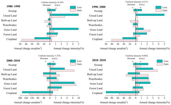
Figure 5.
Category Level Intensity Analysis.
In terms of change intensity, forest land exhibited active change dynamics. The transfer-in and transfer-out change intensities of cropland were both below the average, showing a relatively stable state, which is not consistent with the area change due to its larger area change relative to its own larger base. In addition, built-up land displayed an escalating intensity of change, showing a pronounced decreasing trend. The intensity of change in grassland surpassed the average intensity during 2000–2010, with peak values reached within this period (Lti = 8.56%, Gtj = 9.18%). The intensity of transfers in and out of water bodies was lower than the average change intensity during 1980–1990 but surpassed it during 1990–2018, signaling a shift from stability to activity in water bodies. Overall, the annual average change intensity showed a clear phase with the year 2000 as the dividing line.
3.1.3. Intensity Analysis of LUCC at Transition Level
Figure 6 displays the cross-contingency table of LUCC patterns in the Lower Liaohe River Plain, revealing diverse transformation patterns throughout the study period. The conversion intensity of processes such as forest land to cropland, forest land to grassland, and grassland to forest land, etc., exhibited stable tendencies. Conversely, conversions like cropland to water bodies, forest land to built-up land, and built-up land to cropland demonstrated a persistent avoidance pattern.
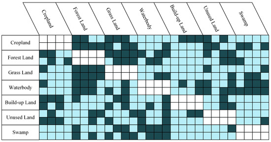
Figure 6.
Cross-contingency table of land use change patterns at transfer levels.
Analysis of the conversion level intensity highlighted that cropland expansion mostly depends on the occupation of forest land, grassland and swamp, with conversions primarily occurring from cropland to grassland and built-up land. The conversion intensity between forest land and grassland indicatied a close spatial distribution pattern between these two land types. Moreover, the conversion intensity of cropland, water bodies, and grassland exhibited a tendency towards urban land in half of the time periods, while the conversion intensity of built-up land out to other land types showed avoidance across almost all time periods.
3.2. Driving Force Analysis of LUCC
3.2.1. Selection of Influencing Factors
A total of 14 factors were selected as independent variables and input to the geodectector for analysis, including elevation, average annual temperature, annual precipitation, total population, and GDP, etc., in the Lower Liahe Plain (Table 2). To comply with the input requirements of the geodetector, the variables were first discretized according to the natural breakpoint method. Kriging interpolation analysis was performed using ArcGIS 10.7 to unveil the spatial characteristics of the study components. A regular grid of 2 km × 2 km consisting of 11,058 sample points was created using the Create Fishing Grid function in ArcGIS. Subsequently, information on all variables was extracted from these sample points for further exploration.
Table 2.
Driving factors of LUCC.
3.2.2. Independent Effects of Factors
Analyzing the driving factors of land use change in the Lower Liaohe River Plain involved selecting four types of land conversion based on cropland area changes (Table 3).
Table 3.
Transformation of cropland area from 2000 to 2018 (km2).
Factor detection results are shown in Table 4. Different land class conversion processes are influenced by distinct factors. Combining the four land type conversion processes, population density (47.10%) has the strongest explanatory power for land type conversion, followed by per capita GDP, GDP, average annual precipitation, the total value in primary industry, the total value in secondary industry, and ET0.
Table 4.
The result of factor detection.
Specifically, in the conversion of cropland to built-up land, aspect did not pass the significance test. ET0 emerged as the strongest explanatory power for this conversion (26.87%), followed by the total value in primary industry, total population, population density and the total value in secondary industry, all with explanatory powers exceeding 21%. When converting cropland into water bodies, slope did not pass the significance test, while SPEI-12 (16.89%) played a key role, followed by GDP (15.84%), average annual temperature (15.45%), and population density (14.83%). In the conversion of forest land into cropland, slope, aspect, and SPEI-12 did not pass the significance test, except for ET0 (21.66%) being the primary influencing factor, followed by total population (8.57%), the total value in primary industry (8.50%), and GDP (8.50%). For the conversion of swamp to cropland, all 14 factors passed the significance test (p < 0.05).
3.2.3. Interaction Effects between Factors
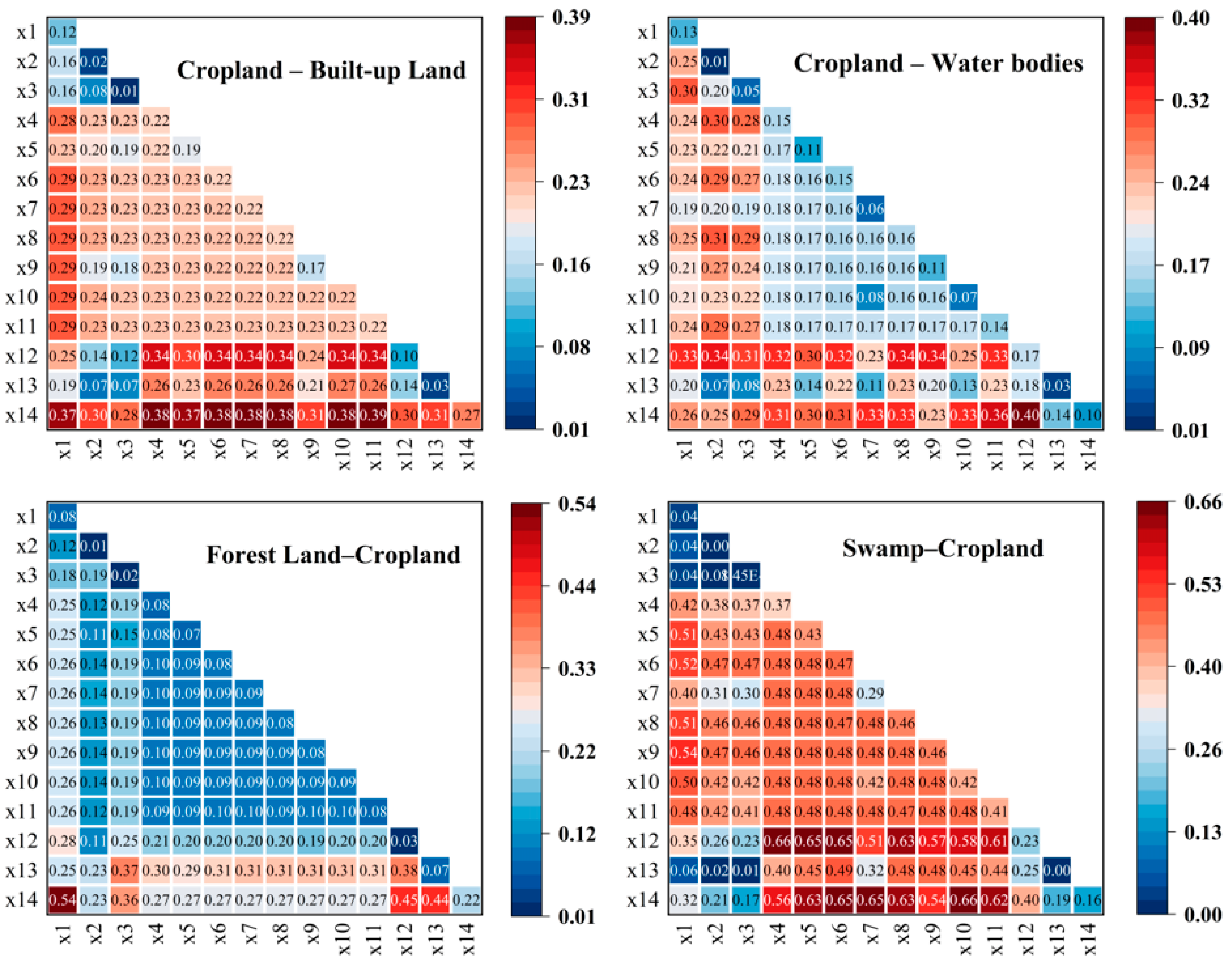
The results of interaction detection for each factor are shown in Figure 7. In the conversion from cropland to built-up land, the interaction of ET0 with factors like average annual temperature, total population, population density, GDP, the total value in primary industry, and the total value in secondary industry showed explanatory powers exceeding 38%. When transitioning from cropland to water bodies, the most influential interaction was between ET0 and SPEI-12, surpassing 40%. In addition, interactions of SPEI-12 with ET0, annual average temperature, population density, GDP, and the total value in secondary industry exhibited influence exceeding 30%, showing non-linear enhancements. In the transformation from forest land to cropland, the single factor with the greatest influence was ET0 and elevation, which had an explanatory power of more than 54%, followed by ET0 and distance to water source at 44.19%. For the conversion from swamp to cropland, stronger explanatory power was seen when SPEI-12, ET0, and other factors interacted. For example, SPEI-12 interacts with annual mean temperature, ET0 interacts with the total population, and ET0 interacts with the total value in primary industry, demonstrating explanatory powers exceeding 65%, indicating a nonlinear enhancement.

Figure 7.
Interactive detection results of the driving factors.
In summary, the key interactions identified in each land use transformation process ar: the total value in secondary industry∩ET0 (38.54%), SPEI-12∩ET0 (40.17%), elevation∩ET0 (54.21%), and the total value in primary industry∩ET0 (65.98%). These interactions highlight the significant roles played by factors such as ET0, SPEI-12, the total value in primary industry, and the total value in secondary industry in the LUCC in the Lower Liaohe River Plain.
3.3. Prediction of Future LUCC
3.3.1. Model Validation
In this paper, the accuracy of the MCCA model was evaluated by predicting mixed land use in 2018 using historical mixed land use data and comparing it with the actual land use in 2018. Specifically, the training parameters and output paths were configured to run the project using land use data from 2010 and 2018 to obtain conversion rules for land categories from 2010 to 2018. Referring to the official manual, the number of regression trees was set to 100, the sampling rate was set to 10%, and 14 features were randomly selected for splitting at each node (mTry). The user manual is accessible at https://github.com/HPSCIL/Mixed_Cell_Cellullar_Automata (accessed on 8 May 2024). Land use data from 1980 to 2018 was then used to calculate historical land use trends (e.g., 2000–2018) and the project’s future land use demands (e.g., 2018–2035). Finally, based on the use of the 2010 land use structure, development potential, and linear projection results, a simulated land use structure for 2018 was generated.
The study achieved an accuracy of 0.8242, with RE at 0.1846, and mcFoM at 0.1204 when comparing simulation results with the actual land use structure. Furthermore, all land use types had out-of-bag root mean square error (OOB-RMSE) values below 0.05, indicating that the selected driving factors reasonably account for LUCC in the study area. Overall, the simulation outcomes of the MCCA model are deemed satisfactory and can be utilized for forecasting future LULC structures.
3.3.2. Time Variation Analysis of Simulation Results
Based on land use data from 2010 and 2018, we forecasted the land use composition of the Lower Liaohe River Plain from 2025 to 2035 (Figure 8). By 2035, cropland accounts for 63.05% of the total area and remains the most widely distributed land use type in the area. In comparison to 2018, cropland, forest land, grassland, and swamp have declined, while water bodies, built-up land, and unused land have increased. Specifically, cropland decreased by 8.79%, forest land and swamp decreased by 45.67% and 45.82%, respectively; built-up land increased by 79.30% and unused land increased by 75.71%. Notably, cropland and built-up areas exhibit the most notable changes when adjusting for land area distribution across different land use types.
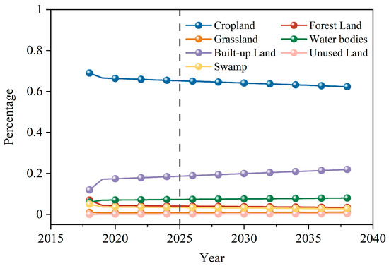
Figure 8.
Prediction of land use structure types.
3.3.3. Land Use Conversion Rules
We input the processed land use data along with the driving factors into the MCCA model to extract quantitative transition rules. The specific parameters were established by consulting the official manual, through which we obtained the transition rule data for each land use type in the Lower Liahe Plain, as illustrated in Figure 9.
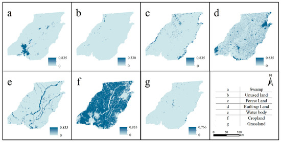
Figure 9.
Transformation rule.
3.3.4. Spatial Variation Analysis of Simulation Results
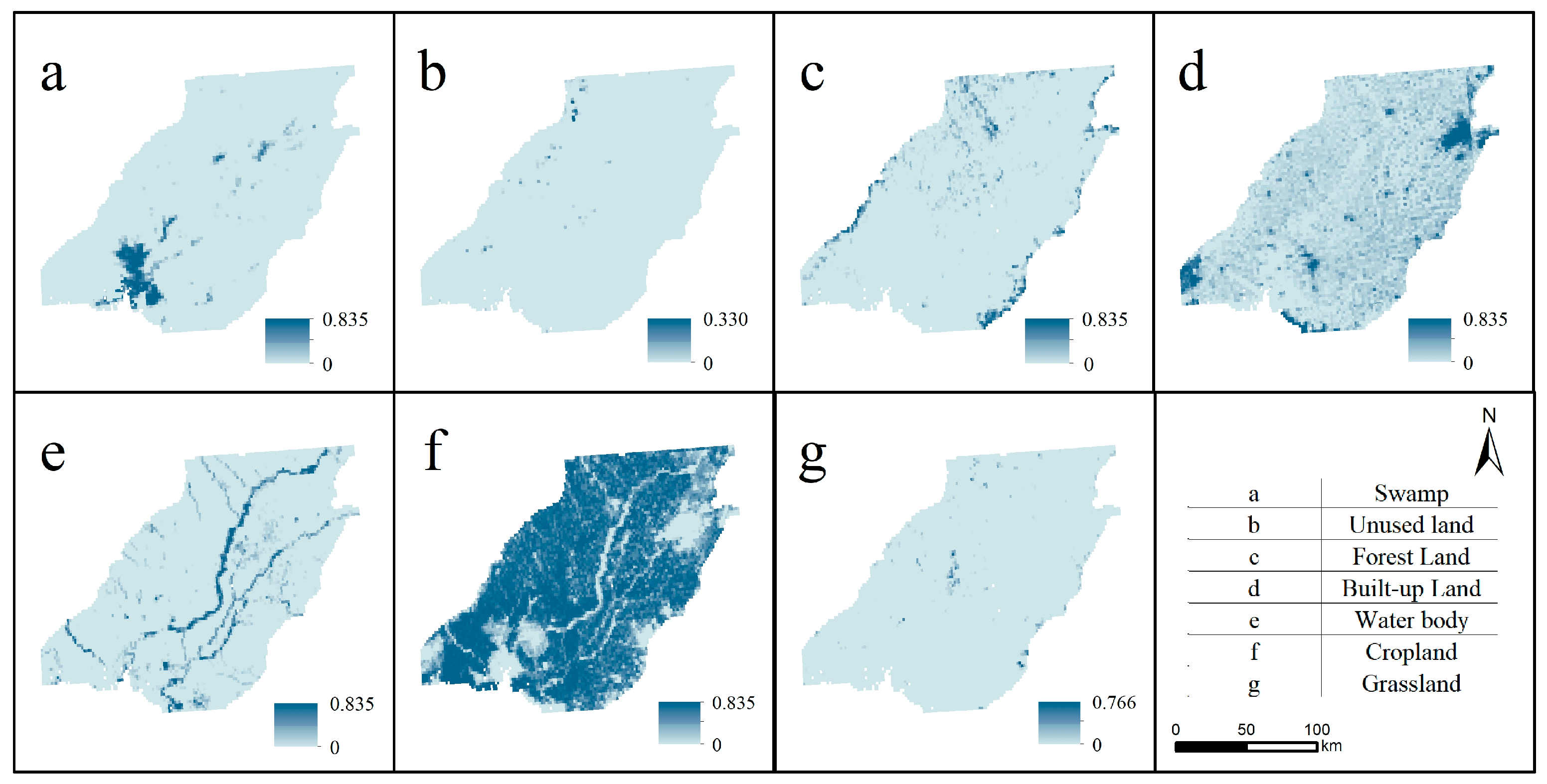
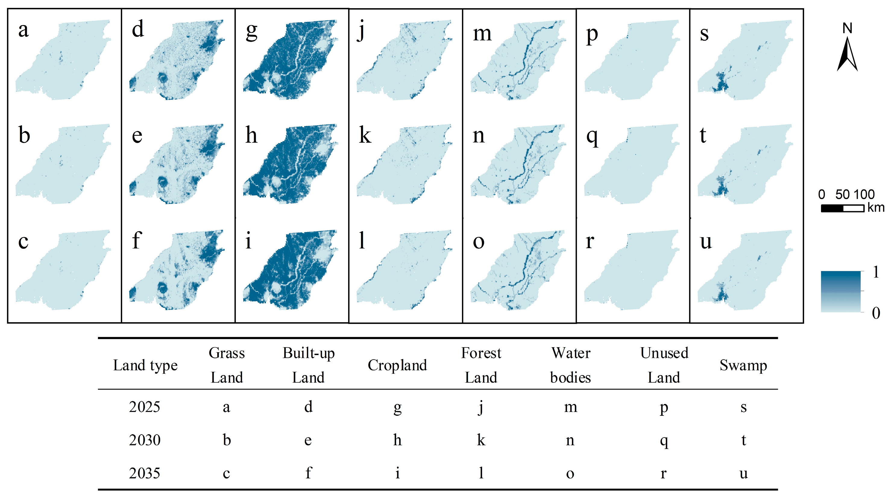
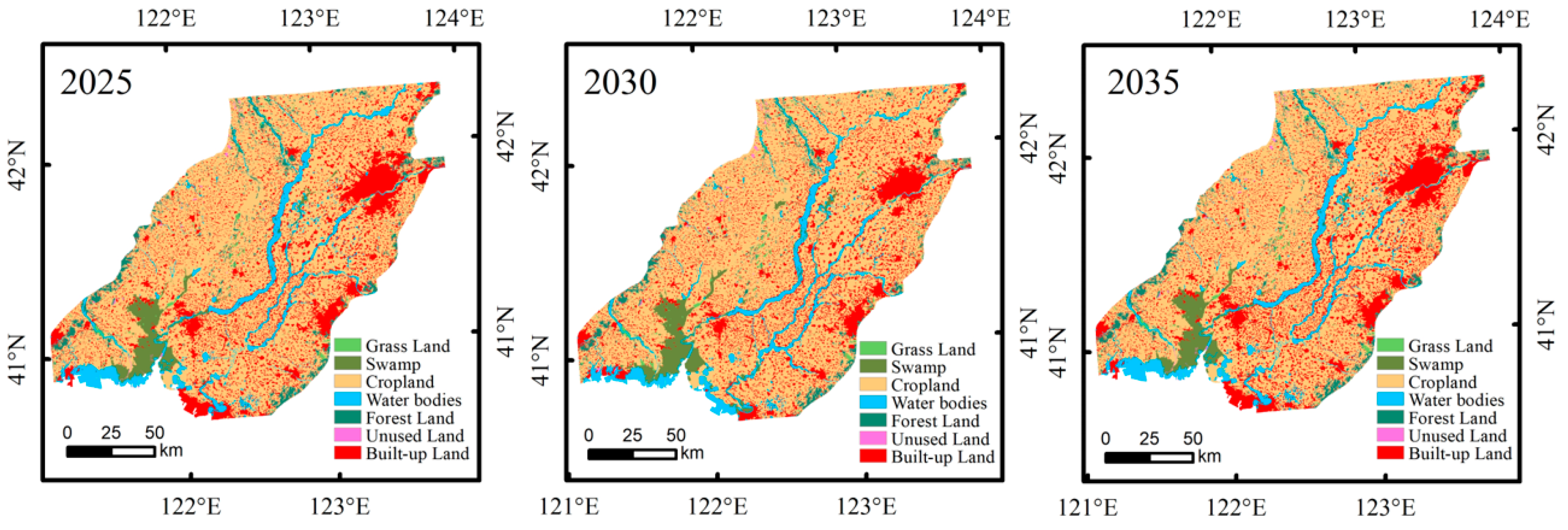
Leveraging the structured driving factor data, the 2018 land use data of the Lower Liaoning River Plain served as the starting point. Subsequently, the density distribution of seven land types in each metacell for 2025, 2030, and 2035 was simulated utilizing projected data on different land cover types. This process also yielded the mixed image metadata for each land type and is depicted in Figure 10. The comprehensive simulation outcomes are presented in Figure 11.
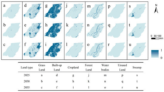
Figure 10.
Distribution map of land use structure from 2025 to 2035.
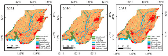
Figure 11.
Simulation results of land use.
Overall, the cropland distribution in the Lower Liaohe River Plain from 2025 to 2035 is concentrated in Jinzhou, Yingkou, Liaoyang and the central and western areas of Shenyang. The spatial distribution remains dense with high overall integrity. The decrease in cropland predominantly occurs in the central sector of the plain. Built-up land is mainly centered in the central part of Panjin, the eastern part of Shenyang, the northeastern part of Fushun, and the southwestern part of Jinzhou, indicating outward expansion. Significant growth in built-up land is observed in the eastern part of Shenyang and the eastern part of Anshan, showing a trend of aggregation. Reductions in forest land are mainly concentrated in Fuxin and northwestern Shenyang, while other land types do not show obvious areas of increase or decrease.
4. Discussion
4.1. LUCC and Transformation Intensity Analysis
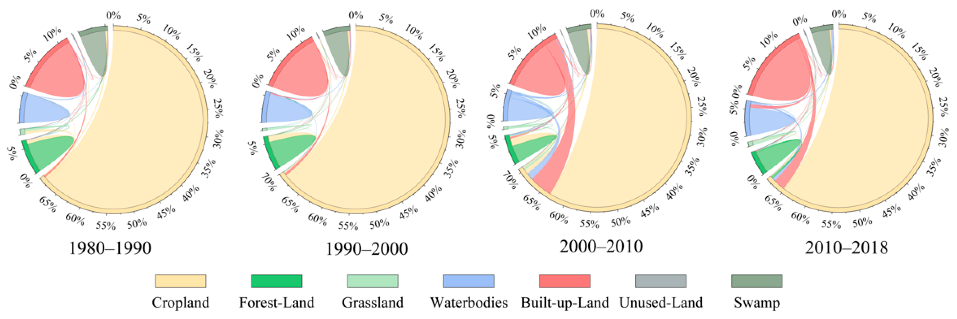
Situated in the downstream region of the Liaohe River Basin, the Lower Liaohe River Plain boasts gentle topography intersected by numerous tributaries, including the Hun River, Xiushui River, and Wangyang River, ensuring abundant water resources. The region’s climate, characterized by both rainfall and warmth, has fostered rapid agricultural growth, establishing cropland as the predominant land type in the Lower Liaohe River Plain. The dominance of cropland, with a relatively concentrated distribution, is evident in the study area. Built-up land and forest land follow in importance, while other land use types cover a smaller area [50]. The transfer of land use reflects the substantial base of cropland, forest land, and built-up land, leading to significant transfers compared to other land types (Figure 12). Prior to 2000, cropland experienced the most rapid expansion; followed by a significant increase in built-up land post-2000, indicating dynamic changes, whereas the forest land area remained consistently active throughout. These findings align with the trajectory analysis conducted by Wang et al., which focused on cropland changes [51].
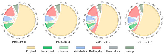
Figure 12.
LUCC in Lower Liaohe River Plain between 1980 and 2018.
Before the 21st century, the growing population in the Lower Liaohe Plain, coupled with increasing food demand, necessitated the clearing of forests and grasslands to expand arable land. However, the rapid growth in population and relatively crude agricultural production methods resulted in heightened water and air pollution in the region, leading to the conversion of significant forest land and grassland areas to other uses. Large-scale deforestation has contributed to soil erosion, serious land degradation, and the rapid deterioration of the ecological environment.
In 2003, the Party Central Committee introduced a strategy to revitalize the old industrial bases in Northeast China, subsequently driving urban transformation and urbanization in Liaoning Province. Since the 21st century, living standards in the Lower Liaohe Plain have improved steadily, urbanization has accelerated, the rate of decrease in forest land area has slowed down, and the urban environment has gradually optimized. The rapid economic development has propelled ongoing adjustments in land use structure. Sun et al. [45] analyzed the driving mechanism of the changing landscape pattern in the Lower Liaohe River Plain from 1986 to 2010. Initially, heavy deforestation of forest land and grassland occurred during the early stages of economic development, followed by a significant decrease that later rebounded due to national initiatives. Concurrently, the expansion of construction land has been continuously, particularly accelerating in later years. Research on the Liaohe River basin has revealed a steady rise in land use intensity and dynamics over time. Urban land conversion rates were notably high, with arable land witnessing significant transfers aligning with the results of this study [52].
4.2. Influences of Driving Factors on LUCC
In recent years, extensive research has been conducted on the relationship between natural and socioeconomic factors and LUCC. The main natural factors affecting land use in the Liaohe region include temperature and precipitation, while socio-economic factors include population, economic factors, spatial factors, fixed asset investment, and urbanization level [45,51,53]. This study focuses on 14 influencing factors encompassing natural, social, and economic factors to investigate the drivers of LUCC in the Lower Liaohe River, building on previous research. Given that cropland dominates the Lower Liaohe Plain, it is reasonable to select different land use conversion processes according to the degree of change in its area and further analyze the driving mechanisms. Key findings reveal that influential factors include ET0, SPEI-12, population density, per capita GDP, and primary industry output, among others. ET0 is an important component of land hydrothermal balance, and different land use types have different vegetation cover and surface albedo, etc. [54,55].
The southern part of the Lower Liaohe River Plain borders the Bohai Sea and the Liaodong Bay, characterized by a temperate semi-humid monsoon climate with abundant water and heat conditions. Therefore, changes in evapotranspiration significantly influence the area’s land use patterns. The SPEI combines temperature, precipitation, and evapotranspiration effects, serving as a wetness and dryness indicator [56]. By incorporating ET0 and SPEI-12 into the analysis, the paper provides a more comprehensive exploration of the factors driving land use change in the Lower Liaohe River Plain, setting it apart from prior studies. In addition, population density is one of the main driving factors of land use change in the region. As socio-economic development progresses, population growth naturally contributes to the expansion of arable and urban land areas. With the development of plantation, forestry, and animal husbandry in the primary sector, the land use pattern in the region is characterized by the ongoing expansion of arable land and a gradual decrease in forested areas.
4.3. Future Land Use Change Scenarios
Future changes in land use patterns reflect a complex interplay between natural and socio-economic factors. In this study, the land use data of 2018 and past driving factors were used to test model accuracy in simulations. Combining the above data, the simulation accurately predicted land use in 2018. Compared with the studies of Zhou and Wu [57,58], who explored different development scenarios and conducted data testing over two periods, their methods provide valuable directions for further in-depth research. In addition, the accuracy of factor selection influences study results. Overall, the simulation outcomes of the MCCA model demonstrate satisfactory performance.
Between 2018 and 2035, cropland in the Lower Liaohe River Plain will decrease, while the urbanization process will become more significant, which aligns with the findings simulated by Lv et al. [59]. Urban expansion may stem from encroachment on forest land and swamps, reflecting the inevitable urbanization trajectory in the region. The introduction of the reform and opening-up policy in 1978 accelerated the development and construction of the region, particularly marked by “the Central Liaoning City Cluster Development Plan”. This plan, endorsed by the provincial government in February 2008, aims for a 76% urbanization rate by 2020, harmonizing urban and rural planning and comprehensively promoting regional integration. Furthermore, as the core of economic development and an important heavy industrial hub in northern China, the Lower Liaohe River Plain boasts high-quality infrastructure that attracts residents, leading to increased construction land availability due to population influx. Given the diversity and complexity of urban spatial changes, modeling mixed land use can provide managers with an understanding of future trends and interactions, empowering decision-makers to advance sustainable urban land development practices [47].
4.4. Relevant Policy Recommendations
As cropland predominates in the lower Liaohe Plain, the government can direct cropland transformation through scientific land planning and management in response to the changing land types. Measures should be taken to restrict the non-agricultural conversion of farmland and prevent land over-exploitation to ensure sustainable cropland resource utilization. Moreover, supporting agricultural science and technology innovation can enhance the efficiency and output of farmland use, in response to the national call for “guaranteeing food security” and “agricultural powerhouse”. As grassland, woodland, and swamp areas are declining, it is crucial to prioritize ecological protection and restoration. Strengthening wetland protection, advancing grassland ecological restoration projects, and advocating for the sustainable management of woodland resources are recommended to foster ecosystem health and development.
In the future, government departments need to enhance land planning and management and formulate and implement ecological protection and restoration programs, particularly focusing on the central plains where land use changes are most prominent. Structural transformation of land use, guided by the government, will mitigate over-exploitation and utilization of land resources to protect the local ecological environment and biodiversity. By 2035, there will be an increase in built-up land and water bodies and a decrease in other land uses. Appropriate infrastructure should be built in due course to meet future urbanization and water resource requirements. In particular, water resources management and protection should be strengthened to ensure the stability and sustainability of the water supply.
4.5. Limitations
In this study, we have developed a comprehensive analytical framework for examining the historical evolutionary patterns, driving mechanisms, and future simulation of LUCC in the Lower Liaohe Plain. In applying the intensity analysis method, the cross-linked table is cited to present the results of the conversion level, which enhances the comparability with related studies. Our research has yielded valuable insights and recommendations that provide a deeper understanding of sustainable land resource management in the region.
Nevertheless, certain limitations exist in this study. Discrepancies in remote sensing resolution and quality in the lower Liaohe region, as well as the substantial span of the study, may affect the accuracy of the research results. In addition, the limited access to data has resulted in a mix of 10-year and 8-year intervals, potentially introducing bias in the interpretation of land use change and affecting the accuracy and comparability of study results. In future studies, this section may be improved.
In the analysis of driving forces, the construction of the evaluation system for driving indicators in land use pattern evolution is found to be imperfect. The density of fishing nets and the number of sampling points of independent variables may impact the results. When conducting the analysis for ET0 and SPEI-12, only results with high correlation were obtained, the influence of positive and negative correlations were not taken into account.
Compared to previous land use simulations, the MCCA model used in this study considers the reality that land use units comprise mixed types with multiple land uses. By 2035, under ideal conditions unperturbed by external influences, projections indicate an increase in built-up land and water bodies and a reduction in other land uses. This conclusion is based on the predictions of future land use demand made by the MCCA model under the assumption of linearity. However, as land use changes often exhibit non-linear characteristics, the model may struggle to accurately capture these fluctuations, leading to prediction deviations. In fact, land use changes cannot be completely isolated from the influence of external environments. Thus, it is crucial to consider significant national-level policies such as the “Five-Year Plan” and regional-level plans like the “Development Plan for the Central City Cluster of Liaoning Province”. These policies will have substantial impacts that cannot be ignored, shaping the future direction of land use development. In situations where external factors, such as policy changes and shifts in the external environment, are unquantifiable, utilizing diverse alternative indicators can enhance the simulation’s accuracy. Furthermore, while the model results demonstrate the selected drivers’ effectiveness in explaining land use changes, there remains room for further exploration into the interaction mechanisms among different factors. By adjusting and optimizing the combination of drivers in a targeted manner, the accuracy and applicability of the model predictions can be enhanced.
5. Conclusions
This study utilizes a combination of intensity analysis, the geodetector model, and the MCCA model to examine the characteristics of land use/cover change, driving mechanisms, and future development trends in the Lower Liaohe Plain, aiming to offer valuable insights for informed land resource allocation and sustainable development. The ensuing results are outlined as follows:
Cropland dominates the land cover in the Lower Liaohe Plain. From 1980 to 2018, built-up land and water bodies exhibited increasing trends, while grassland, cropland, forest land, unused land, and swamps experienced declines. Notably, cropland, forest land, and built-up land witnessed more dynamic changes, while water bodies remained relatively stable. The pattern of land type transfers displayed a consistent direction, with cropland and forest land primarily converting into built-up areas.
Land use changes in the Lower Liaohe Plain are primarily driven by socio-economic factors, with population density, output value of the primary industry, and GDP demonstrating significant explanatory power. The combined impact of these factors surpasses that of any individual factor.
The MCCA model yielded accuracy results, with an overall accuracy of 0.8242, RE of 0.1846, and mcFoM of 0.1204. All land use types show OBB-RMSE values below 0.05, indicating that the chosen drivers effectively account for LUCC in the research area. Projections suggest an increase in built-up land and water bodies by 2035, alongside reductions in other land use categories, particularly in the central region of the plains.
Author Contributions
Conceptualization, R.W. (Rina Wu) and R.W. (Ruinan Wang); methodology, R.W. (Rina Wu); software, R.W. (Ruinan Wang); validation, R.W. (Rina Wu), L.L. and J.J.; formal analysis, R.W. (Ruinan Wang); investigation, L.L.; resources, R.W. (Rina Wu); data curation, R.W. (Ruinan Wang); writing—original draft preparation, R.W. (Rina Wu); writing—review and editing, R.W. (Ruinan Wang); visualization, L.L. and J.J.; supervision, R.W. (Rina Wu); funding acquisition, R.W. (Rina Wu). All authors have read and agreed to the published version of the manuscript.
Funding
This research was funded by Liaoning Philosophy and Social Science Planning Fund Project (Grant No. L23CJY001).
Institutional Review Board Statement
Not applicable.
Informed Consent Statement
Not applicable.
Data Availability Statement
All data can be accessed through the provided website.
Acknowledgments
We thank everyone who helped during the manuscript writing. We also thank the journal editor and the anonymous reviewers for their useful comments and great efforts on this paper.
Conflicts of Interest
The authors declare that they all have no potential conflicts of interest.
References
- Dong, J.; Kuang, W.; Liu, J. Continuous land cover change monitoring in the remote sensing big data era. Sci. China Earth Sci. 2017, 60, 2223–2224. [Google Scholar] [CrossRef]
- Jia, S.; Yang, Y. Spatiotemporal and Driving Factors of Land-Cover Change in the Heilongjiang (Amur) River Basin. Remote Sens. 2023, 15, 3730. [Google Scholar] [CrossRef]
- Verburg, P.H.; Crossman, N.; Ellis, E.C.; Heinimann, A.; Hostert, P.; Mertz, O.; Nagendra, H.; Sikor, T.; Erb, K.-H.; Golubiewski, N.; et al. Land system science and sustainable development of the earth system: A global land project perspective. Anthropocene 2015, 12, 29–41. [Google Scholar] [CrossRef]
- Yang, H.; Zhong, X.; Deng, S.; Nie, S. Impact of LUCC on landscape pattern in the Yangtze River Basin during 2001–2019. Ecol. Inf. 2022, 69, 101631. [Google Scholar] [CrossRef]
- Feng, H.; Wang, S.; Zou, B.; Nie, Y.; Ye, S.; Ding, Y.; Zhu, S. Land use and cover change (LUCC) impacts on Earth’s eco-environments: Research progress and prospects. Adv. Space Res. 2023, 71, 1418–1435. [Google Scholar] [CrossRef]
- Song, W.; Cao, S.; Du, M.; Lu, L. Distinctive roles of land-use efficiency in sustainable development goals: An investigation of trade-offs and synergies in China. J. Clean. Prod. 2023, 382, 134889. [Google Scholar] [CrossRef]
- Cao, J.; Zhang, X.; Deo, R.; Gong, Y.; Feng, Q. Influence of stand type and stand age on soil carbon storage in China’s arid and semi-arid regions. Land Use Policy 2018, 78, 258–265. [Google Scholar] [CrossRef]
- Zhu, E.; Deng, J.; Zhou, M.; Gan, M.; Jiang, R.; Wang, K.; Shahtahmassebi, A. Carbon emissions induced by land-use and land-cover change from 1970 to 2010 in Zhejiang, China. Sci. Total Environ. 2019, 646, 930–939. [Google Scholar] [CrossRef] [PubMed]
- Li, C.; Wu, J. Land use transformation and eco-environmental effects based on production-living-ecological spatial synergy: Evidence from Shaanxi Province, China. Environ. Sci. Pollut. Res. 2022, 29, 41492–41504. [Google Scholar] [CrossRef]
- Sy, S.; Quesada, B. Anthropogenic land cover change impact on climate extremes during the 21st century. Environ. Res. Lett. 2020, 15, 034002. [Google Scholar] [CrossRef]
- De Koning, G.H.J.; Benítez, P.C.; Muñoz, F.; Olschewski, R. Modelling the impacts of payments for biodiversity conservation on regional land-use patterns. Landsc. Urban Plann. 2007, 83, 255–267. [Google Scholar] [CrossRef]
- Yan, D.; Scott, R.L.; Moore, D.J.P.; Biederman, J.A.; Smith, W.K. Understanding the relationship between vegetation greenness and productivity across dryland ecosystems through the integration of PhenoCam, satellite, and eddy covariance data. Remote Sens. Environ. 2019, 223, 50–62. [Google Scholar] [CrossRef]
- Meaza, H.; Tsegaye, D.; Nyssen, J. Allocation of degraded hillsides to landless farmers and improved livelihoods in Tigray, Ethiopia. Nor. Geogr. Tidsskr. 2016, 70, 1–12. [Google Scholar] [CrossRef]
- Hoyer, R.; Chang, H. Assessment of freshwater ecosystem services in the Tualatin and Yamhill basins under climate change and urbanization. Appl. Geogr. 2014, 53, 402–416. [Google Scholar] [CrossRef]
- Cui, J.; Zhu, M.; Liang, Y.; Qin, G.; Li, J.; Liu, Y. Land Use/Land Cover Change and Their Driving Factors in the Yellow River Basin of Shandong Province Based on Google Earth Engine from 2000 to 2020. ISPRS Int. J. Geo Inf. 2022, 11, 163. [Google Scholar] [CrossRef]
- Hishe, S.; Bewket, W.; Nyssen, J.; Lyimo, J. Analysing past land use land cover change and CA-Markov-based future modelling in the Middle Suluh Valley, Northern Ethiopia. Geocarto Int. 2019, 35, 225–255. [Google Scholar] [CrossRef]
- Homer, C.; Dewitz, J.; Jin, S.; Xian, G.; Costello, C.; Danielson, P.; Gass, L.; Funk, M.; Wickham, J.; Stehman, S.; et al. Conterminous United States land cover change patterns 2001–2016 from the 2016 National Land Cover Database. ISPRS J. Photogramm. Remote Sens. 2020, 162, 184–199. [Google Scholar] [CrossRef]
- Tian, Y.; Yin, K.; Lu, D.; Hua, L.; Zhao, Q.; Wen, M. Examining Land Use and Land Cover Spatiotemporal Change and Driving Forces in Beijing from 1978 to 2010. Remote Sens. 2014, 6, 10593–10611. [Google Scholar] [CrossRef]
- Wang, L.; Wang, J.; Liu, Z.; Zhu, J.; Qin, F. Evaluation of a deep-learning model for multispectral remote sensing of land use and crop classification. Crop J. 2022, 10, 1435–1451. [Google Scholar] [CrossRef]
- Liang, Y.; Zeng, J.; Li, S. Examining the Spatial Variations of Land Use Change and Its Impact Factors in a Coastal Area in Vietnam. Land 2022, 11, 1751. [Google Scholar] [CrossRef]
- Huang, B.; Huang, J.; Gilmore Pontius, R.; Tu, Z. Comparison of Intensity Analysis and the land use dynamic degrees to measure land changes outside versus inside the coastal zone of Longhai, China. Ecol. Indic. 2018, 89, 336–347. [Google Scholar] [CrossRef]
- Zhang, M.; Wang, J.; Zhang, Y.; Wang, J. Ecological response of land use change in a large opencast coal mine area of China. Resour. Policy 2023, 82, 103551. [Google Scholar] [CrossRef]
- da Cunha, E.R.; Santos, C.A.G.; da Silva, R.M.; Bacani, V.M.; Pott, A. Future scenarios based on a CA-Markov land use and land cover simulation model for a tropical humid basin in the Cerrado/Atlantic forest ecotone of Brazil. Land Use Policy 2021, 101, 105141. [Google Scholar] [CrossRef]
- Deng, Z.; Quan, B. Intensity Analysis to Communicate Detailed Detection of Land Use and Land Cover Change in Chang-Zhu-Tan Metropolitan Region, China. Forests 2023, 14, 939. [Google Scholar] [CrossRef]
- Aldwaik, S.Z.; Pontius, R.G. Intensity analysis to unify measurements of size and stationarity of land changes by interval, category, and transition. Landsc. Urban Plan. 2012, 106, 103–114. [Google Scholar] [CrossRef]
- Quan, B.; Pontius, R.G.; Song, H. Intensity Analysis to communicate land change during three time intervals in two regions of Quanzhou City, China. GISci. Remote Sens. 2019, 57, 21–36. [Google Scholar] [CrossRef]
- Xu, D.; Zhang, K.; Cao, L.; Guan, X.; Zhang, H. Driving forces and prediction of urban land use change based on the geodetector and CA-Markov model: A case study of Zhengzhou, China. Int. J. Digital Earth 2022, 15, 2246–2267. [Google Scholar] [CrossRef]
- Wu, F.; Mo, C.; Dai, X. Analysis of the Driving Force of Land Use Change Based on Geographic Detection and Simulation of Future Land Use Scenarios. Sustainability 2022, 14, 5254. [Google Scholar] [CrossRef]
- Hu, Y.; Hu, Y. Land Cover Changes and Their Driving Mechanisms in Central Asia from 2001 to 2017 Supported by Google Earth Engine. Remote Sens. 2019, 11, 554. [Google Scholar] [CrossRef]
- Li, K.; Feng, M.; Biswas, A.; Su, H.; Niu, Y.; Cao, J. Driving Factors and Future Prediction of Land Use and Cover Change Based on Satellite Remote Sensing Data by the LCM Model: A Case Study from Gansu Province, China. Sensors 2020, 20, 2757. [Google Scholar] [CrossRef]
- Zhang, X.; Yang, Y.; Gao, H.; Xu, S.; Feng, J.; Qin, T. Land Cover Changes and Driving Factors in the Source Regions of the Yangtze and Yellow Rivers over the Past 40 Years. Land 2024, 13, 259. [Google Scholar] [CrossRef]
- Zhou, Y.; Li, X.; Liu, Y. Land use change and driving factors in rural China during the period 1995-2015. Land Use Policy 2020, 99, 105048. [Google Scholar] [CrossRef]
- Ning, C.; Subedi, R.; Hao, L. Land Use/Cover Change, Fragmentation, and Driving Factors in Nepal in the Last 25 Years. Sustainability 2023, 15, 6957. [Google Scholar] [CrossRef]
- Wei, Z.; Du, N.; Yu, W. Land use change and its driving factors in the ecological function area: A case study in the Hedong Region of the Gansu Province, China. J. Arid. Land 2024, 16, 71–90. [Google Scholar] [CrossRef]
- Liu, C.; Li, W.; Zhu, G.; Zhou, H.; Yan, H.; Xue, P. Land Use/Land Cover Changes and Their Driving Factors in the Northeastern Tibetan Plateau Based on Geographical Detectors and Google Earth Engine: A Case Study in Gannan Prefecture. Remote Sens. 2020, 12, 3139. [Google Scholar] [CrossRef]
- Ronizi, S.R.A.; Negahban, S.; Mokarram, M. Investigation of land use changes in rural areas using MCDM and CA-Markov chain and their effects on water quality and soil fertility in south of Iran. Environ. Sci. Pollut. Res. 2022, 29, 88644–88662. [Google Scholar] [CrossRef]
- Sun, C.; Bao, Y.; Vandansambuu, B.; Bao, Y. Simulation and Prediction of Land Use/Cover Changes Based on CLUE-S and CA-Markov Models: A Case Study of a Typical Pastoral Area in Mongolia. Sustainability 2022, 14, 15707. [Google Scholar] [CrossRef]
- Chen, Z.; Huang, M.; Zhu, D.; Altan, O. Integrating Remote Sensing and a Markov-FLUS Model to Simulate Future Land Use Changes in Hokkaido, Japan. Remote Sens. 2021, 13, 2621. [Google Scholar] [CrossRef]
- Li, H.; Fang, C.; Xia, Y.; Liu, Z.; Wang, W. Multi-Scenario Simulation of Production-Living-Ecological Space in the Poyang Lake Area Based on Remote Sensing and RF-Markov-FLUS Model. Remote Sens. 2022, 14, 2830. [Google Scholar] [CrossRef]
- Liu, X.; Liang, X.; Li, X.; Xu, X.; Ou, J.; Chen, Y.; Li, S.; Wang, S.; Pei, F. A future land use simulation model (FLUS) for simulating multiple land use scenarios by coupling human and natural effects. Landsc. Urban Plan. 2017, 168, 94–116. [Google Scholar] [CrossRef]
- He, C.; Zhang, J.; Liu, Z.; Huang, Q. Characteristics and progress of land use/cover change research during 1990-2018. Acta Geogr. Sin. 2021, 76, 2730–2748. [Google Scholar] [CrossRef]
- Cao, K.; Zhang, W.; Wang, T. Spatio-temporal land use multi–objective optimization: A case study in Central China. Trans. GIS 2019, 23, 726–744. [Google Scholar] [CrossRef]
- Qiao, Z.; Jiang, Y.; He, T.; Lu, Y.; Xu, X.; Yang, J. Land use change simulation:progress, challenges, and prospects. Acta Ecol. Sin. 2022, 42, 5165–5176. [Google Scholar]
- Liang, X.; Guan, Q.; Clarke, K.C.; Chen, G.; Guo, S.; Yao, Y. Mixed-cell cellular automata: A new approach for simulating the spatio-temporal dynamics of mixed land use structures. Landsc. Urban Plan. 2021, 205, 103960. [Google Scholar] [CrossRef]
- Sun, C.; Yan, X. Driving mechanism analysis of landscape pattern change in the Lower Liaohe Plain based on GIS-Logistic coupling model. Acta Ecol. Sin. 2014, 34, 7280–7292. [Google Scholar]
- Liu, X.; Bian, Z.; Sun, Z.; Wang, C.; Sun, Z.; Wang, S.; Wang, G. Integrating Landscape Pattern Metrics to Map Spatial Distribution of Farmland Soil Organic Carbon on Lower Liaohe Plain of Northeast China. Land 2023, 12, 1344. [Google Scholar] [CrossRef]
- Abdullahi, S.; Pradhan, B. Land use change modeling and the effect of compact city paradigms: Integration of GIS-based cellular automata and weights-of-evidence techniques. Environ. Earth Sci. 2018, 77, 251. [Google Scholar] [CrossRef]
- Yang, J.; Gong, J.; Gao, J.; Ye, Q. Stationary and systematic characteristics of land use and land cover change in the national central cities of China using intensity analysis: A case study of Wuhan City. Resour. Sci. 2019, 41, 701–716. [Google Scholar]
- Wang, J.F.; Li, X.H.; Christakos, G.; Liao, Y.L.; Zhang, T.; Gu, X.; Zheng, X.Y. Geographical Detectors-Based Health Risk Assessment and its Application in the Neural Tube Defects Study of the Heshun Region, China. Int. J. Geog. Inf. Sci. 2010, 24, 107–127. [Google Scholar] [CrossRef]
- Liu, H.; Wang, Q.; Dong, X.; Bian, Z.; Sun, F. Cultivated Land Use Change and Protecting Exploitation Ways in Typical Region of Lower Reaches of Liaohe River Plain. Res. Agric. Modern. 2010, 31, 608–611. [Google Scholar]
- Wang, Q.; Song, G. Changes of cultivated land pattern and its spatial driving factors in the typical regions of Lower Liaohe Plain. Trans. Chin. Soc. Agric. Eng. 2021, 37, 275–283. [Google Scholar]
- Wang, X.; Liu, W.; Zhang, L.; Zheng, J.; Wang, D.; Wang, L. Dynamic Analysis of Landscape Pattern in Liaohe Watershed in the past Ten Years. J. Fujian For. Sci. Technol. 2015, 42, 9–15. [Google Scholar]
- Li, H.Y.; Man, W.D.; Li, X.Y.; Ren, C.Y.; Wang, Z.M.; Li, L.; Jia, M.M.; Mao, D.H. Remote sensing investigation of anthropogenic land cover expansion in the low-elevation coastal zone of Liaoning Province, China. Ocean Coast. Manag. 2017, 148, 245–259. [Google Scholar] [CrossRef]
- Varamesh, S.; Mohtaram Anbaran, S.; Shirmohammadi, B.; Al-Ansari, N.; Shabani, S.; Jaafari, A. How Do Different Land Uses/Covers Contribute to Land Surface Temperature and Albedo? Sustainability 2022, 14, 16963. [Google Scholar] [CrossRef]
- Pal, S.; Ziaul, S. Detection of land use and land cover change and land surface temperature in English Bazar urban centre. Egypt. J. Remote Sens. Space Sci. 2017, 20, 125–145. [Google Scholar] [CrossRef]
- Ali, S.; Basit, A.; Umair, M.; Makanda, T.A.; Shaik, M.R.; Ibrahim, M.; Ni, J. The Role of Climate Change and Its Sensitivity on Long-Term Standardized Precipitation Evapotranspiration Index, Vegetation and Drought Changing Trends over East Asia. Plants 2024, 13, 399. [Google Scholar] [CrossRef] [PubMed]
- Wu, X.; Liu, X.; Zhang, D.; Zhang, J.; He, J.; Xu, X. Simulating mixed land-use change under multi-label concept by integrating a convolutional neural network and cellular automata: A case study of Huizhou, China. GISci. Remote Sens. 2022, 59, 609–632. [Google Scholar] [CrossRef]
- Zhou, S.; Peng, L. Integrating a mixed-cell cellular automata model and Bayesian belief network for ecosystem services optimization to guide ecological restoration and conservation. Land Degrad. Dev. 2022, 33, 1579–1595. [Google Scholar] [CrossRef]
- Lv, L.; Yang, Y.; Jiang, J.; Qiao, H.; Bai, S. Evolution and Prediction of Landscape Pattern in the Xialiaohe Plain. Geomat. World 2021, 28, 73–78. [Google Scholar]


Disclaimer/Publisher’s Note: The statements, opinions and data contained in all publications are solely those of the individual author(s) and contributor(s) and not of MDPI and/or the editor(s). MDPI and/or the editor(s) disclaim responsibility for any injury to people or property resulting from any ideas, methods, instructions or products referred to in the content. |
© 2024 by the authors. Licensee MDPI, Basel, Switzerland. This article is an open access article distributed under the terms and conditions of the Creative Commons Attribution (CC BY) license (https://creativecommons.org/licenses/by/4.0/).