

Unveiling the Soil beyond Definitions: A Holistic Framework for Sub-Regional Soil Quality Assessment and Spatial Planning


Abstract
:1. Introduction
1.1. Soil Quality—The Main Goals and Objectives Dealing with Its Preservation in the International Panorama
1.2. Land Quality or Soil Quality? A Literature Review
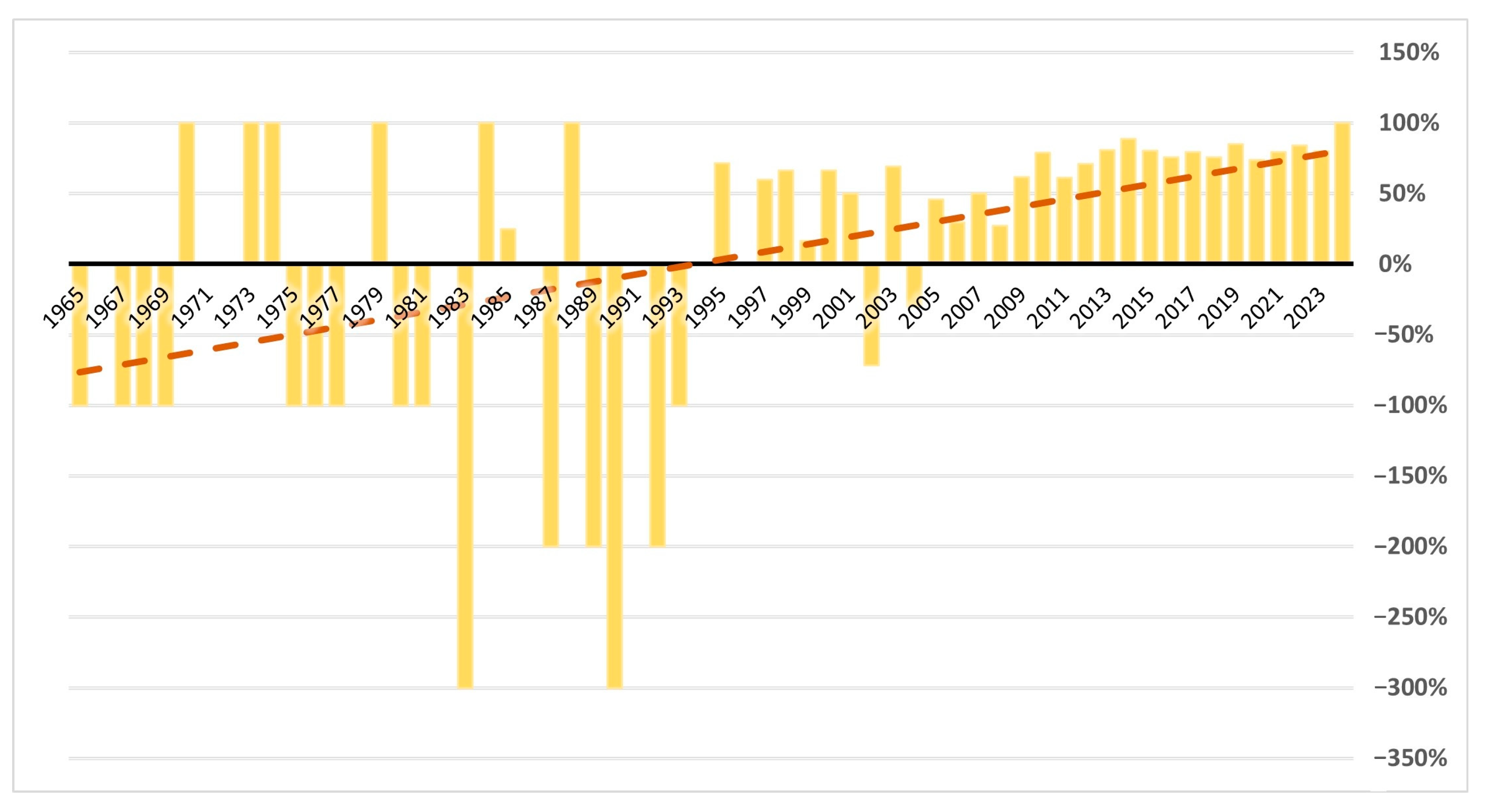
- Temporally speaking, soil quality is gaining prominence in the literature at the expense of land quality, even within the fields of spatial and strategic planning.
- In absolute terms, the number of scientific texts tagged with soil quality far exceeds those tagged with land quality, even within the fields of spatial and strategic planning, indicating a richer body of literature.
- Traditionally, the term “land quality” has primarily denoted suitability for human uses, such as agricultural or pastoral purposes, reflecting an anthropocentric viewpoint. Over time, however, soil quality, originally associated with pedogenic and agronomic contexts, has evolved to encompass the inherent quality of the soil itself, beyond its practical implications or usefulness for human activities. Moreover, discussions on soil ecosystem services include cultural and recreational services, reflecting a broader conception of the term soil quality under a novel eco-centric perspective compared to the past.
1.3. Face the Problem: How—and Why—to Evaluate the Soil Quality and Degradation at Sub-Regional Scale?
2. Materials and Methods
- Indicators of soil properties are considered to be “the physical (e.g., porosity, texture), chemical (e.g., pH, readily available phosphate), and biological (e.g., microbial biomass) characteristics of a soil” [37].
- Indicators of soil services provide information about soil’s utility and importance for the surrounding environment and ecosystems, as well as human activities. This includes “not only […] the provision of goods and services related to the intended land use (e.g., production services such as food and wood production) but also […] goods and services such as the provision of aesthetic beauty, cultural heritage and preservation of biodiversity” [39].
- Indicators related to main current and potential threats for soil quality over the territory show the consequential effects of human pressures and soil’s intrinsic and extrinsic vulnerability and sensitivity to them.
3. Results
- Laws and proposals at the European scale (Soil Monitoring Law and Nature restoration Law);
- Scientific literature;
- European project: LIFE + MGN.
3.1. Data Reference Sources and Their Availability/Usability Referring to the Different Scales
3.2. Presentation of the Case Study: The Lombardy Region and the Province of Brescia
3.3. Methodology Application
3.4. Indicator Selection
3.4.1. Soil Properties
- Electric conductivity. It is a soil property related to the soluble nutrients, both anions and cations. It is positively related to good nutrient availability for plants. When lacking, soils can present an unstable structure and a tendency to dispersion, while its abundance can bring salinity problems [68].
- Soil Organic Carbon. It is one of the most indicative soil properties, as it is related to microbial processes, nutrient storage, plant available water capacity, infiltration capability, aggregate formation and stability, bulk density, cation exchange capacity and soil enzymes, and invertebrate presence. It also influences soil erosion tendency, soil structure, and other physical properties [69].
- Bulk density in topsoil and subsoil. Bulk density is an indicator of soil porosity, carbon, and moisture content and, consequently, soil productivity and quality. It is related to various physical, chemical, and biological properties of soil and depends on several factors, including anthropogenic ones. It is one of the most significant indicators for detailing thermophysical characteristics and agricultural production [70].
- Available P. Phosphorus is a crucial macronutrient essential for plant growth and metabolism. Most plant activities, including growth, respiration, and reproduction, hinge on phosphorus levels in the soil. Furthermore, phosphorus is a vital component of photosynthesis. It is correlated with other properties, e.g., soils rich in organic matter offer superior organic phosphate supplies for plant uptake compared to soils with lower organic content. Additionally, soils with minimal leaching contain higher phosphorus levels compared to soils experiencing more significant leaching [71].
- Available N. It refers to the nitrogen availability for plants in soils, necessary for crop production. It depends on the rate of N mineralization, namely microbial decomposition, which is controlled by many environmental factors, such as temperature, moisture, and aeration. This is essential, since almost all the N in the soil is present in complex organic compounds not yet available for plants [72].
- Other nutrients (K, Ca, Mg, Fe, Mn). Besides C, N, P, and S, plants need other elements for normal growth and life cycles. Together with primary nutrients (N, P, and K), some are called secondary elements, such as K, Ca, and Mg, and other are micronutrients, like Fe and Mn. All these elements are essential for plant life, and their deficiency limits the productivity or may halt plant growth completely [73]
- Water holding capacity (WHC) and available holding capacity (AWC). Water in soil, held or available, depends on various factors, including plant cover type, plant density, growth stage, root depth, evaporation and transpiration rates, water infiltration amount, wetting rate, soil horizonation or layering nature, and the duration since the last rainfall or irrigation event. Measuring the quantity of water available for plant use influencing the likelihood of deep percolation proves beneficial in numerous agronomic scenarios [74].
- pH. It is a fundamental soil property that can significantly impact the availability and toxicity of elements, the activity of microbial groups, plant disease, the decomposition of natural and synthetic chemicals, and the microbial transformation of different atmospheric gases like CH4 [68].
- Microbial biomass. It plays a crucial role in nutrient transformations and storage, such as the conversion of organic nitrogen into forms accessible to plants. Agricultural systems relying on internal nitrogen sources depend on microbial biomass and its activity to supply nitrogen to crops. The carbon within microbial biomass serves as stored energy for microbial processes, making microbial biomass carbon a potential indicator of microbial activity [75].
- Ratio of bacteria and fungi. Bacteria and fungi play a crucial role in nutrient cycling and the functioning of terrestrial ecosystems. The ratio of fungi to bacteria (F/B ratio) is employed as an index to examine the effects of environmental changes and human-induced disturbances on the structure and functionality of soil microbial communities [76].
- Coarse fragments. Coarse fragments in soil, also known as rock fragments or stones, can influence soil properties as bulk density, porosity, saturated hydraulic conductivity, and pore size distribution [77].
- Munsell color. This notation is a widely used system for describing and classifying soil colors. Soil color can indirectly reflect some aspects of soil properties, such as organic matter content and drainage conditions [78].
- Morphological aspects (slope and depth). Morphological indicators are probably the most common and simplest, with easily observed characteristics, yet are known for influencing other soil properties like nutrient concentrations [79].
- Humidity. Soil moisture, constituting one of the three phases in the soil system alongside soil minerals (solids) and air, is integral to various aspects of soil behavior. The mechanical properties of the soil, including consistency, compatibility, cracking, swelling, shrinkage, and density, depend on soil moisture content. Additionally, soil moisture plays a pivotal role in plant growth, the organization of natural ecosystems, and biodiversity. In the agricultural sector, ensuring the application of sufficient and timely moisture for irrigation, tailored to the soil–moisture–plant environment, is crucial for successful crop production [80].
- Corg/Norg. The carbon-to-nitrogen (C/N) ratio in soils describes the relationship between the concentration of C and N and is a sensitive indicator of soil quality, since it can assess carbon and nitrogen nutrient cycling in soils [81].
- CaCO3. Calcium carbonate (CaCO3) content in soil can significantly influence soil quality and properties, affecting mainly (and positively) pH value and with a positive role against clay dispersion [82].
- Surface and groundwater quality. Degradation of soil quality has repercussions for water quality. This is evident through the leaching of pesticides and excess nutrients into surface and groundwater, coupled with seawater intrusion into aquifers [83].
- Exchangeable sodium percentage (ESP) and sodium adsorption ratio (SAR). Soil salinity/sodicity is a key factor in evaluating soil quality, with particular influence on agricultural productivity and sustainability. In cases of extreme values, soil appears poor in physical properties, permeability, and vegetation presence. To access soil sodicity, exchangeable sodium percentage (ESP) and sodium adsorption ratio (SAR) are normally used, with the possibility of linking the two with existing relationships in the literature [84].
- Texture. Soil texture refers to the relative proportions of sand, silt, and clay particles in a soil. This property plays a crucial role in influencing soil quality since it affects microbial activity, water content, soil temperature, aggregation, and porosity, together with gas exchange capacity, respiration of roots and microorganisms, and carbon storage capacity [85].
3.4.2. Soil Services
- Total amount of fodder produced (Biomass production—forage production). As proposed by Schirpke et al., the quantification of this service can start from the grasslands and pastures distributed over the territory, to which average production values provided by ISTAT are associated [41]. The same approach can potentially be applied to any production type, including woody biomass, provided that appropriate statistical data are available.
- Potential productivity (Biomass production—forage production). Land supply service can also be evaluated in potential terms, considering these aspects. Such land characterization is provided by the Geoportal of Brescia Province.
- Carbon dioxide stored/sequestered in vegetation (Climate regulation—carbon sequestration). For service quantification, a useful source is the National Forest inventory related to land cover classes and converted to carbon. It is associated with INFC data on epigeal phytomass, root/shoot ratio, and current increase in epigeal tree volume per hectare, evaluated by forest categories, according to an adaptation of the method used in the National Carbon Accounting [86], based on the IPCC methodology [87].
- Retention capacity (Water quality, supply and regulation—discharge, infiltration, and flood control). As proposed by Morri et al., to quantify the service, one can use the retention coefficients typical of forest cover and management developed for the Marche Region, which provide volumes of water retained in the basin and thus subtracted from surface runoff. Information about forest management should be associated with these coefficients [88]. Alternatively, Nedkov and Burkhard [89] propose using retention rates for land cover classes, providing an estimate of volumes potentially retained during rainfall events. The coefficients need to be supplemented with vegetation cover information, such as the Forest Map of the Lombardy Region or, similarly, the DUSAF or Corine Land Cover.
- Protective capacity (Water quality, supply, and regulation—filtering capacity). A useful indicator is the protective capacity on surface and groundwater, geolocalized by the Lombardy Region. Water quality information at the hydrographic basin scale should also be considered for a complete characterization of the service.
- Landscape value (Aesthetic, cultural, recreational value supply). The Geoportals of Lombardy Region and Brescia Province provide a wide characterization of landscape features and elements in the territory, along with the geolocation of relevant sites from a naturalistic and ecological perspective.
- Recreational value and inspiration for culture, arts, educational and spiritual values, sense of identity (Aesthetic, cultural, recreational value supply). The Geoportals of Lombardy Region and Brescia Province offer extensive information on cultural and artistical features and elements in the territory. The opportunity for their use is considered an ecosystem service of the soil, providing support, survival, and value.
- Common butterfly index (Biodiversity conservation—agricultural and forest ecosystems). Butterflies play a significant ecological role, serving as vital pollinators, a source of sustenance for other species, and an index of ecosystem health. Butterflies not only play a key role in pollination, but are also sensitive to climate change, which impacts pollination patterns and habitat loss, making them highly responsive indicators. Consequently, a thriving population of butterflies often signifies a more robust and healthier ecosystem [90].
- Index of common avifauna in forest and agricultural habitat (Biodiversity conservation—agricultural and forest ecosystems). Birds are highly suitable for monitoring the effects of global environmental change due to their well-established history of global monitoring efforts. They are relatively easy to detect and identify, benefit from well-developed and cost-effective census methods, and our knowledge of the population biology, behavior, and life history is quite comprehensive (except in tropical regions), as pointed out by Xiao et al. [91]. Additionally, birds exhibit predictable population responses to environmental changes and are both widespread and diverse, with approximately 10,000 species found globally [91].
- Percentage of agricultural land affected by landscape elements with high diversity (Biodiversity conservation—agricultural and forest ecosystems). As underlined by Zarden et al., linear landscape features, such as ditches, hedgerows, rows of trees, and field margins, serve as crucial habitats and sources of ecosystem services, acting as ecological infrastructure for species within agricultural environments [92]. To enhance the representation of landscape composition in large-scale environmental evaluations at the regional level, it is essential to create spatial maps illustrating the distribution of these elements. In their research, Zarden et al. propose a methodology for modelling the spatial distribution of linear landscape elements, starting from LUCAS land use and land cover data [92].
- Standing and fallen deadwood (Biodiversity conservation—agricultural and forest ecosystems). As pointed out by Seidling et al., living trees and their decaying wood remnants together form the fundamental structural elements of forest ecosystems [93]. The arrangement of tree stands within a forest significantly influences species diversity. Multiple studies have demonstrated strong associations between the structural characteristics of tree stands and the diversity of fauna for various taxonomic groups and ecological guilds. Geolocation of these species can be obtained from the INFC database, combined with the Forest Map on the Geoportal of Lombardy Region.
- Forest connectivity (Biodiversity conservation—agricultural and forest ecosystems). As pointed out by Vogt et al., forest connectivity and, consequently, fragmentation significantly influence biodiversity, ecosystem services, and the mounting impact of human-driven land use changes [94]. Forest fragmentation can result in the isolation and depletion of species and genetic diversity, the deterioration of habitat quality, and a diminished capacity of the forest to support essential natural processes required for ecosystem well-being [94]. In their analysis, Vogt et al. present a methodology for the quantification of forest connectivity, for which Copernicus Discrete Classification data can be used [94].
- Diversity of tree species (Biodiversity indicators for agricultural and forest ecosystems). The diversity of tree species, and the prevalence of native species, is a well-recognized indicator of ecosystem health. Geolocation of these species can be obtained from the INFC database, combined with the Forest Map on the Geoportal of the Lombardy Region.
- HNV farming (Biodiversity indicators for agricultural and forest ecosystems). Proposed at the European level, it is composed of “3 sub-indicators that measure: the areas in which extensive agriculture is practiced and with a high proportion of semi-natural vegetation (e.g., meadows and pastures); areas with a mosaic of low-intensity agriculture (e.g., rice fields, olive groves, orchards) and natural, semi-natural and structural elements (e.g., hedges, dry stone walls, groves, rows, small watercourses, etc.) that contribute to the diversity of the agricultural landscape; agricultural areas that support rare species or a high richness of species of European or global interest” [48]. The methodology proposed for the Lombardy Region is based on an adaptation of the National Rural Network and develops the indicator with a very small reference cell, providing highly detailed results (cell size: 100 × 100 m) [67].
3.4.3. Soil Threats
- Heavy metal concentration (Contamination). Heavy metals adversely affect plant quality and yield and alter the size, composition, and activity of the microbial community, negatively impacting soil microbial properties such as respiration rate and enzyme activity, which are useful indicators of soil pollution [95].
- Zn concentration (Contamination). The balance of zinc (Zn) in soil, whether deficient or excessive, can affect soil functions and have repercussions for animal and human health. Zinc is a micronutrient critical for various biological processes, and maintaining the right concentration is crucial for ecosystems’ and organisms’ well-being [96].
- Contaminated areas (Contamination). This involves locating contaminated sites with soil and/or groundwater pollution that have undergone a reclamation process and received certification of reclamation or permanent safety. The Geoportal of Lombardy Region maps such sites, including those with soil and groundwater contamination, sites with contamination of either soil or groundwater, sites with groundwater contamination and completed soil reclamation, and sites with completed reclamation awaiting certification.
- Index of sensitivity to nutrient and pollutant inputs (Contamination). This sensitivity, as conceptualized by the Lombardy Region in the Annex to the 7 May 2007 D.d.g. of the Lombardy Region [66], can be classified using average indices of plant associations essential for environmental unit structure. Units with a low nitrogen substrate are more sensitive than those with a high nitrogen substrate. In this light, specific parameters connecting land use and this sensitivity can be used, as presented in the cited Annex [66].
- Environmental pressures and sensitivities (Sealing). This information provides elements of territorial development and the anthropization processes that pose risks to environmental sensitivity elements. The Geoportal of the Province of Brescia provides an assessment of settlement pressure, particularly in Map 3.3 of the PTCP titled “Environmental Pressures and Sensitivities”, which is a valuable resource for evaluating the impact of human development on environmental factors in the Brescia Province.
- Landscape degradation (Sealing). Landscape degradation, understood as the “deterioration” of landscape features, is caused by both abandonment-related processes, leading to a gradual loss of defining elements (including subsoil and surface degradation, vegetation, buildings, hydraulic structures, etc.), and by innovative interventions that introduce incongruous changes (in terms of size, shape, materials, usage, etc.) that do not align with the characteristics of the existing landscape, failing to achieve a satisfying reconfiguration of a new landscape–settlement framework. The Geoportal of the Province of Brescia reports this information and detects landscape degradation phenomena, both areal and punctual.
- Infrastructure fragmentation index (Sealing). As proposed in the 2021 Environmental Strategic Assessment of the Regional Lombard Plan [65], this index estimates the areas affected by fragmentation caused by infrastructure presence, but it can also be readily applied to the impact of other human activities. Calculating this indicator requires data on land use in the study area and the surface areas associated with various land use types, obtainable from sources like DUSAF or Corine Land Cover [65], along with a map of the infrastructure network, for example, from the Mobility Infrastructure layer of the Lombardy Region.
- Landscape compromise index (Sealing). Proposed in the 2021 Environmental Strategic Assessment of the Regional Lombard Plan [65], this index considers that transforming open spaces into built and urbanized areas creates residual areas that may suffer from degradation and underutilization. Widespread urbanization also leads to fragmentation, affecting the use of surrounding territory, ecosystem services, and environmental relationships. In this way, the proposed index evaluates both changes in settlement form, which deteriorates with an increase, and an overall occupancy index. These components are combined to provide an index of landscape compromise. Calculating this index requires data on land use in the study area and surface areas associated with various land use types, obtainable from sources like DUSAF or Corine Land Cover, [65], along with a map of the infrastructure network, which can be sourced from the Mobility Infrastructure layer of the Lombardy Region.
- Recovery time factor (Sealing). As proposed in the Annex to the 7 May 2007 D.d.g. of the Lombardy Region [66], recovery is evaluated in relation to the ecological value of environmental units damaged by human activities. The index is calculated on a scale from 1 to 3, based on development times of over 30 years, between 30 and 100 years, and exceeding 100 years. Calculating this indicator requires, for the study area, data on land use and surface areas associated with different land use types, obtainable from sources like DUSAF or Corine Land Cover, along with the parameters specified in the cited Annex [66].
- Habitat standard per capita (Sealing). Defined by the 2021 Environmental Strategic Assessment of the Regional Plan of Lombardy Region [65], this concept assesses the ability of territories to support human functions, defining quantitative thresholds for evaluating the sustainability of anthropogenic pressures within a specific geographic area. Calculating this indicator requires, for the study area, data on land use and surface areas associated with various land uses, obtainable from sources like DUSAF or Corine Land Cover [65]. Additionally, it considers the population or equivalent inhabitants within the study area.
- Matrix (Sealing). Defined by the 2021 Environmental Strategic Assessment of the Regional Plan of Lombardy Region [65], the “Matrix” is determined by the type of element or recurring combinations of elements that are prevalent and interconnected in a landscape, influencing its structure and fundamental characteristics. For it to be recognized, these elements must make up at least 51% of the landscape coverage. A more stable environment, less susceptible to landscape disruption, is associated with a matrix value of at least 60%. This value represents the dominance of specific land use types, determined using data on land use and surface areas associated from sources like DUSAF or Corine Land Cover [65].
- Overall naturalistic value index (Sealing). Proposed in the Annex to the 7 May 2007 D.d.g. of the Lombardy Region [66], this index combines the degree of naturalness (N), the state of danger and rarity (P), and the potential for temporal and spatial restoration (R). The indicator is obtained by estimating the components N, P, and R and assigning a value from 0 to 10, with the maximum value being the overall index value for the examined environmental unit. Calculating this indicator requires data on land use in the study area and surface areas associated with different land use types, obtainable from sources like DUSAF or Corine Land Cover, along with the parameters specified in the Annex to the 7 May 2007 D.d.g. of the Lombardy Region [66].
- Territorial biopotentiality (Sealing). Defined by the 2021 Environmental Strategic Assessment of the Regional Plan of Lombardy Region [65], this indicator, among other outcomes, provides information about the degree of stability, evolutionary trends, effects of potential transformations, and biological deficit introduced by transformations or environmental resource depletion in the study areas. Calculating this indicator requires data on land use in the study area and the surface areas associated with different land use types, obtainable from sources like DUSAF or Corine Land Cover [65]. Additionally, parameters characterizing territorial biopotentiality (possibly referring to specific environmental parameters) for each type of land use are required, and these can be found in the technical documentation of the indicator within the 2021 Environmental Strategic Assessment of the Regional Plan of Lombardy Region [65].
- Soil erosion processes (Erosion). Soil erosion threatens agriculture and the natural environment and is caused by factors such as water, wind, and morphological aspects. Evaluating indicators of soil erosion is crucial, especially in the context of climate change, thus in future scenarios. A prior reference for the indicator is represented by the ESDAC database with data sources at different scales, together with erosion indicators for Italy by CMCC.
- Soil defense works (Erosion). The Soil Defense Works Information Service (ODS) provides an up-to-date picture of the maintenance and securing of slopes and watercourses to mitigate hydraulic and hydrogeological risk in Lombardy. The Geoportal of Lombardy Region provides this resource.
- Biodiversity vulnerability (Biodiversity loss). The effect of biodiversity loss can be computed by combining the effects of different data inputs over the territory, such as soil erosion, climate change, habitat fragmentation, salinity, and compaction. Potential threats are mapped by ESDAC.
- Hydrogeological risk forecasts (Landslides and floods). Reliable forecasts about climatic conditions and their changes in the coming years are essential in the climate change era. A valuable source of data forecasts is the Euro-Mediterranean Centre of Climate Change.
- Drainage area index (Landslides and floods). Defined by the 2021 Environmental Strategic Assessment of the Regional Plan of Lombardy Region [65], the Idren index is the ratio between the draining surface and the total surface area of each domain, representing the percentage of non-impermeable soil. The index determines the effects of urbanization on soil permeability, in terms of anthropogenic pressure. Calculating this index requires data on land use in the study area and the surface areas associated with different land use types, obtainable from sources like DUSAF or Corine Land Cover. Additionally, you would require coefficients for the draining surface for each type of land cover, which can be found in the 2021 Environmental Strategic Assessment of the Regional Plan of Lombardy Region [65].
- Landslide vulnerability (Landslides and floods). This evaluates the spatial probability of generic landslide occurrence, considering factors such as elevation, lithology, climatic conditions, and land cover [97]. ESDAC provides valuable resources in this direction.
- Characterization of particular vulnerable areas (Landslides and floods). Geolocating areas particularly subject to hydrological risk is essential, especially for their position. Various sources in the regional and provincial Geoportals provide this service.
- Strategic forested areas for landslide defense (Landslides and floods). As reported by Forbes and Keith, forests and trees play a significant role in preventing landslide, confirmed by various scientific studies and with different contributions. For instance, deep-rooted plants help reduce soil moisture through transpiration, lowering the risk of landslides, and forests can act as a barrier against smaller debris flows and rock falls, mitigating their impact and blocking their progress [98]. An interesting data source in this direction can be found in the Geoportal of Brescia Province.
4. Discussion
5. Conclusions
Author Contributions
Funding
Institutional Review Board Statement
Informed Consent Statement
Data Availability Statement
Acknowledgments
Conflicts of Interest
References
- Hou, D.; Bolan, N.S.; Tsang, D.C.W.; Kirkham, M.B.; O’Connor, D. Sustainable soil use and management: An interdisciplinary and systematic approach. Sci. Total Environ. 2020, 729, 138961. [Google Scholar] [CrossRef] [PubMed]
- Directorate-General for Research and Innovation (European Commission). Caring for Soil Is Caring for Life: Ensure 75% of Soils Are Healthy by 2030 for Healthy Food, People, Nature and Climate: Interim Report of the Mission Board for Soil Health and Food; Publications Office of the European Union: Luxembourg, 2020. [Google Scholar]
- Kopittke, P.M.; Menzies, N.W.; Wang, P.; McKenna, B.A.; Lombi, E. Soil and the intensification of agriculture for global food security. Environ. Int. 2019, 132, 105078. [Google Scholar] [CrossRef]
- General Assembly United Nations Organization. Transforming Our World: The 2030 Agenda for Development Sustainable; General Assembly United Nations Organization: New York, NY, USA, 2015. [Google Scholar]
- Noel, S.; Stewart, N. Reaping Economic and Environmental Benefits from Sustainable Land Management Economics of Land Degradation Initiative: Report for Policy and Decision Makers; Naomi Stewart (UNU-INWEH) and Hannes Etter (GIZ): Bonn, Germany, 2015. [Google Scholar]
- De Castro, P.; Prodi, R. Corsa Alla Terra: Cibo e Agricoltura Nell’era Della Nuova Scarsità, 2nd ed.; con una postfazione dell’autore; Donzelli Editore: Roma, Italy, 2012. [Google Scholar]
- FAO. FAO Strategy on Mainstreaming Biodiversity across Agricultural Sectors; FAO: Roma, Italy, 2020. [Google Scholar] [CrossRef]
- Pezzagno, M.; Richiedei, A. Quale futuro per la rendita? Riflessioni e tendenze di ricerca. Arch. Studi Urbani Reg. 2021, 129, 209–231. [Google Scholar] [CrossRef]
- Joint Research Centre (European Commission). Mapping and Assessment of Ecosystems and Their Services: An EU Wide Ecosystem Assessment in Support of the EU Biodiversity Strategy; Publications Office of the European Union: Luxembourg, 2020. [Google Scholar]
- Teixeira Da Silva, R.; Fleskens, L.; Van Delden, H.; Van Der Ploeg, M. Incorporating soil ecosystem services into urban planning: Status, challenges and opportunities. Landsc. Ecol. 2018, 33, 1087–1102. [Google Scholar] [CrossRef]
- Breure, A.; De Deyn, G.; Dominati, E.; Eglin, T.; Hedlund, K.; Van Orshoven, J.; Posthuma, L. Ecosystem services: A useful concept for soil policy making! Curr. Opin. Environ. Sustain. 2012, 4, 578–585. [Google Scholar] [CrossRef]
- Delibas, M.; Tezer, A.; Kuzniecow Bacchin, T. Towards embedding soil ecosystem services in spatial planning. Cities 2021, 113, 103150. [Google Scholar] [CrossRef]
- Ministry of the Environment and Energy Security. Strategia Nazionale Biodiversità 2030; Ministero dell’Ambiente e della Sicurezza Energetica Direzione Generale Patrimonio Naturalistico e Mare Divisione III–Strategie della Biodiversità: Roma, Italy, 2023. [Google Scholar]
- European Parliament and Council. Proposal for a Directive on Soil Monitoring and Resilience; European Parliament and Council: Brussels, Belgium, 2023. [Google Scholar]
- European Parliament and Council. Proposal for a Regulation on Nature Restoration; European Parliament and Council: Brussels, Belgium, 2022. [Google Scholar]
- Soil Resources, Management and Conservation Service (Ed.) A Framework for Land Evalution; FAO: Rome, Italy, 1981. [Google Scholar]
- Pieri, C.J.M.G.; World Bank (Eds.) Land Quality Indicators; World Bank discussion papers, no. 315; World Bank: Washington, DC, USA, 1995. [Google Scholar]
- Briassoulis, H. Combating Land Degradation and Desertification: The Land-Use Planning Quandary. Land 2019, 8, 27. [Google Scholar] [CrossRef]
- Ray, S.K.; Bhattacharyya, T.; Reddy, K.R.; Pal, D.K.; Chandran, P.; Tiwary, P.; Mandal, D.K.; Mandal, C.; Prasad, J.; Sarkar, D.; et al. Soil and land quality indicators of the Indo-Gangetic Plains of India. Curr. Sci. 2014, 107, 1470–1486. [Google Scholar]
- Buondonno, A.; Coppola, E. Qualità del suolo, concetti ed applicazioni. Un’analisi critica. Ital. J. Agronomy. 2009, 4, 5–12. [Google Scholar] [CrossRef]
- Mausel, P.W. Soil quality in illinois—An example of a soils geography resource analysis∗. Prof. Geogr. 1971, 23, 127–136. [Google Scholar] [CrossRef]
- Bünemann, E.K.; Bongiorno, G.; Bai, Z.; Creamer, R.E.; De Deyn, G.; De Goede, R.; Fleskens, L.; Geissen, V.; Kuyper, T.W.; Mäder, P.; et al. Soil quality—A critical review. Soil Biol. Biochem. 2018, 120, 105–125. [Google Scholar] [CrossRef]
- Doran, J.W.; Parkin, T.B. Defining and Assessing Soil Quality; SSSA Special Publications; Doran, J.W., Coleman, D.C., Bezdicek, D.F., Stewart, B.A., Eds.; Soil Science Society of America and American Society of Agronomy: Madison, WI, USA, 2015; pp. 1–21. [Google Scholar] [CrossRef]
- Doran, J.W.; Parkin, T.B. Quantitative Indicators of Soil Quality: A Minimum Data Set; SSSA Special Publications; Doran, J.W., Jones, A.J., Eds.; Soil Science Society of America: Madison, WI, USA, 2015; pp. 25–37. [Google Scholar] [CrossRef]
- Karlen, D.L.; Mausbach, M.J.; Doran, J.W.; Cline, R.G.; Harris, R.F.; Schuman, G.E. Soil Quality: A Concept, Definition, and Framework for Evaluation (A Guest Editorial). Soil Sci. Soc. Am. J. 1997, 61, 4–10. [Google Scholar] [CrossRef]
- Liu, Y.; Wang, H.; Zhang, H.; Liber, K. A comprehensive support vector machine-based classification model for soil quality assessment. Soil Tillage Res. 2016, 155, 19–26. [Google Scholar] [CrossRef]
- Golub, J. Sovereignty and Subsidiarity in EU Environmental Policy. Political Stud. 1996, 44, 686–703. [Google Scholar] [CrossRef]
- Ceccarelli, T.; Bajocco, S.; Salvati, L.; Perini, L. Investigating syndromes of agricultural land degradation through past trajectories and future scenarios. Soil Sci. Plant Nutr. 2014, 60, 60–70. [Google Scholar] [CrossRef]
- Tobias, S.; Conen, F.; Duss, A.; Wenzel, L.M.; Buser, C.; Alewell, C. Soil sealing and unsealing: State of the art and examples. Land Degrad. Dev. 2018, 29, 2015–2024. [Google Scholar] [CrossRef]
- Directorate General for the Environment (European Commission). Guidelines on Best Practice to Limit, Mitigate or Compensate Soil Sealing; Publications Office of the European Union: Luxembourg, 2012; Available online: https://data.europa.eu/doi/10.2779/75498 (accessed on 29 January 2024).
- Directorate-General for Environment (European Commission); Amec; BIO by Deloitte (BIO); Institute for Environmental Studies; Vienna University of Economics and Business (WU). Study Supporting Potential Land Targets under the 2014 Land Communication: Final Report; Publications Office of the European Union: Luxembourg, 2014; Available online: https://data.europa.eu/doi/10.2779/53343 (accessed on 23 January 2024).
- Haslmayr, H.-P.; Geitner, C.; Sutor, G.; Knoll, A.; Baumgarten, A. Soil function evaluation in Austria—Development, concepts and examples. Geoderma 2016, 264, 379–387. [Google Scholar] [CrossRef]
- Oliveira, E.; Tobias, S.; Hersperger, A. Can Strategic Spatial Planning Contribute to Land Degradation Reduction in Urban Regions? State of the Art and Future Research. Sustainability 2018, 10, 949. [Google Scholar] [CrossRef]
- SOS4life. Linee Guida per un Sistema di Compensazione del Consumo di Suolo (Desealing e Scambio Crediti di Superficie) e Misure per Promuovere gli Interventi di Rigenerazione Urbana; Action B.3.2; SOS4life: Forlì, Italy, 2020; Available online: https://www.sos4life.it/wp-content/uploads/SOS4Life_Linee-guida-per-un-sistema-di-compensazione-del-consumo-di-suolo_B3.2.pdf (accessed on 23 March 2024).
- Pompilio, M. Governing the vast area after Law 56-2014: Unprecedented synergy between municipal and provincial planning? EyesReg J. Reg. Sci. 2016, 6, 25–29. [Google Scholar]
- Bouma, J. Soil science contributions towards Sustainable Development Goals and their implementation: Linking soil functions with ecosystem services. Z. Pflanzenernähr. Bodenk. 2014, 177, 111–120. [Google Scholar] [CrossRef]
- Vrebos, D.; Bampa, F.; Creamer, R.; Gardi, C.; Ghaley, B.; Jones, A.; Rutgers, M.; Sandén, T.; Staes, J.; Meire, P. The Impact of Policy Instruments on Soil Multifunctionality in the European Union. Sustainability 2017, 9, 407. [Google Scholar] [CrossRef]
- EEA ETC/ULS. Soil Monitoring in Europe. Indicators and Thresholds for Soil Quality Assessments; EEA ETC/ULS: Bonn, Germany, 2021. [Google Scholar]
- Corvalán, C.; Hales, S.; McMichael, A.J.; Millennium Ecosystem Assessment (Program); World Health Organization. Ecosystems and Human Well-Being: Health Synthesis. In Millennium Ecosystem Assessment; World Health Organization: Geneva, Switzerland, 2005. [Google Scholar]
- EEA (Ed.) Europe’s Environment: The Second Assessment: An Overview; Publications Office of the European Communities: Luxembourg, 1998. [Google Scholar]
- Schirpke, U.; Marino, D.; Marucci, A.; Palmieri, M.; Scolozzi, R. Operationalising ecosystem services for effective management of protected areas: Experiences and challenges. Ecosyst. Serv. 2017, 28, 105–114. [Google Scholar] [CrossRef]
- Epifani, R. Indicazioni per il Monitoraggio Ambientale. Ph.D. Thesis, Università degli Studi di Milano, Milan, Italy, 2009. [Google Scholar]
- Marzaioli, R.; D’Ascoli, R.; De Pascale, R.A.; Rutigliano, F.A. Soil quality in a Mediterranean area of Southern Italy as related to different land use types. Appl. Soil Ecol. 2010, 44, 205–212. [Google Scholar] [CrossRef]
- Ballabio, C.; Panagos, P.; Monatanarella, L. Mapping topsoil physical properties at European scale using the LUCAS database. Geoderma 2016, 261, 110–123. [Google Scholar] [CrossRef]
- AbdelRahman, M.A.E.; Tahoun, S. GIS model-builder based on comprehensive geostatistical approach to assess soil quality. Remote Sens. Appl. Soc. Environ. 2019, 13, 204–214. [Google Scholar] [CrossRef]
- Abuzaid, A.S.; Abdellatif, A.D.; Fadl, M.E. Modeling soil quality in Dakahlia Governorate, Egypt using GIS techniques. Egypt. J. Remote Sens. Space Sci. 2021, 24, 255–264. [Google Scholar] [CrossRef]
- Baroudy, A.A.E.; Ali, A.M.; Mohamed, E.S.; Moghanm, F.S.; Shokr, M.S.; Savin, I.; Poddubsky, A.; Ding, Z.; Kheir, A.M.S.; Aldosari, A.A.; et al. Modeling Land Suitability for Rice Crop Using Remote Sensing and Soil Quality Indicators: The Case Study of the Nile Delta. Sustainability 2020, 12, 9653. [Google Scholar] [CrossRef]
- Diaz-Gonzalez, F.A.; Vuelvas, J.; Correa, C.A.; Vallejo, V.E.; Patino, D. Machine learning and remote sensing techniques applied to estimate soil indicators—Review. Ecol. Indic. 2022, 135, 108517. [Google Scholar] [CrossRef]
- Juhos, K.; Czigány, S.; Madarász, B.; Ladányi, M. Interpretation of soil quality indicators for land suitability assessment—A multivariate approach for Central European arable soils. Ecol. Indic. 2019, 99, 261–272. [Google Scholar] [CrossRef]
- Järvan, M.; Vettik, R.; Adamson, A. Assessment of plant nutrients’ dynamics in organically and conventionally managed soils by means of different extraction methods. Acta Agric. Scand. Sect. B—Soil Plant Sci. 2017, 67, 191–201. [Google Scholar] [CrossRef]
- Boudjabi, S.; Chenchouni, H. On the sustainability of land applications of sewage sludge: How to apply the sewage biosolid in order to improve soil fertility and increase crop yield? Chemosphere 2021, 282, 131122. [Google Scholar] [CrossRef] [PubMed]
- Paz-Ferreiro, J.; Fu, S. Biological Indices for Soil Quality Evaluation: Perspectives and Limitations. Land Degrad. Dev. 2016, 27, 14–25. [Google Scholar] [CrossRef]
- Atti del Convegno Nazionale. La Conoscenza della Qualità del Suolo Attraverso L’utilizzo di Indicatori Biologici ed Ecotossicologici; Atti del Convegno Nazionale di Torino: Turin, Italy, 2004. [Google Scholar]
- Bagnall, D.K.; Morgan, C.L.S.; Bean, G.M.; Liptzin, D.; Cappellazzi, S.B.; Cope, M.; Greub, K.L.H.; Rieke, E.L.; Norris, C.E.; Tracy, P.W.; et al. Selecting soil hydraulic properties as indicators of soil health: Measurement response to management and site characteristics. Soil Sci. Soc. Am. J. 2022, 86, 1206–1226. [Google Scholar] [CrossRef]
- Keesstra, S.D.; Bouma, J.; Wallinga, J.; Tittonell, P.; Smith, P.; Cerdà, A.; Montanarella, L.; Quinton, J.N.; Pachepsky, Y.; van der Putten, W.H.; et al. The significance of soils and soil science towards realization of the United Nations Sustainable Development Goals. Soil 2016, 2, 111–128. [Google Scholar] [CrossRef]
- Arrouays, D.; Leenaars, J.G.B.; Richer-de-Forges, A.C.; Adhikari, K.; Ballabio, C.; Greve, M.; Grundy, M.; Guerrero, E.; Hempel, J.; Hengl, T.; et al. Soil legacy data rescue via GlobalSoilMap and other international and national initiatives. GeoResJ 2017, 14, 1–19. [Google Scholar] [CrossRef] [PubMed]
- McBratney, A.B.; Mendonça Santos, M.L.; Minasny, B. On digital soil mapping. Geoderma 2003, 117, 3–52. [Google Scholar] [CrossRef]
- Kasampalis, D.; Alexandridis, T.; Deva, C.; Challinor, A.; Moshou, D.; Zalidis, G. Contribution of Remote Sensing on Crop Models: A Review. J. Imaging 2018, 4, 52. [Google Scholar] [CrossRef]
- Minasny, B.; McBratney, A.B. Digital soil mapping: A brief history and some lessons. Geoderma 2016, 264, 301–311. [Google Scholar] [CrossRef]
- Bianchi, S.; Richiedei, A. Territorial Governance for Sustainable Development: A Multi-Level Governance Analysis in the Italian Context. Sustainability 2023, 15, 2526. [Google Scholar] [CrossRef]
- Munafò, M. Soil Consumption, Spatial Dynamics and Ecosystem Services, 2023 ed.; Report SNPA; ISPRA: Rome, Italy, 2023. [Google Scholar]
- Munafò, M. Soil Consumption, Spatial Dynamics and Ecosystem Services, 2022 ed.; Report SNPA; ISPRA: Rome, Italy, 2022. [Google Scholar]
- Lombardy Region. Criteria for the Implementation of the Policy of Reducing Land Consumption. Draft integration of the PTR under l.r. 31/14—Update 2021. Lombardy Region: Milan, Italy. Available online: https://normelombardia.consiglio.regione.lombardia.it/NormeLombardia/Accessibile/main.aspx?view=showdoc&iddoc=lr002014112800031 (accessed on 23 March 2024).
- Pavesi, F.C.; Pezzagno, M. SPONGE LAND (SCAPE). Prime Indicazioni per la Pianificazione D’area Vasta. In Downscaling, Rightsizing. Contrazione Demografica e Riorganizzazione Spaziale. Resilienza nel Governo del Territorio; Brunetta, G., Caldirace, O., Russo, M., Sargolini, M., Eds.; Planum Publisher: Rome, Italy, 2021; Volume 4, pp. 156–163. [Google Scholar]
- Lombardy Region. Strategic Environmental Assessment of PTR 2021. Environmental Report; Lombardy Region: Milan, Italy, 2021. [Google Scholar]
- Lombardy Region. Technical and Design Criteria and Guidelines for the Improvement of the Relationship between Road Infrastructure and the Natural Environment; Lombardy Region: Milan, Italy, 2007. [Google Scholar]
- Lombardy Region. Environmental Monitoring Plan. Annex 4: Methodology for the Calculation of the Indicator CI 37—HNV (High Nature Value) Farming and Update to 2016; Lombardy Region: Milan, Italy, 2017. [Google Scholar]
- Smith, J.L.; Doran, J.W. Measurement and Use of pH and Electrical Conductivity for Soil Quality Analysis; SSSA Special Publications; Doran, J.W., Jones, A.J., Eds.; Soil Science Society of America: Madison, WI, USA, 2015; pp. 169–185. [Google Scholar] [CrossRef]
- Reeves, D.W. The role of soil organic matter in maintaining soil quality in continuous cropping systems. Soil Tillage Res. 1997, 43, 131–167. [Google Scholar] [CrossRef]
- Al-Shammary, A.A.G.; Kouzani, A.Z.; Kaynak, A.; Khoo, S.Y.; Norton, M.; Gates, W. Soil Bulk Density Estimation Methods: A Review. Pedosphere 2018, 28, 581–596. [Google Scholar] [CrossRef]
- Tale, K.S.; Ingole, D.S. A Review on Role of Physico-Chemical Properties in Soil Quality. Chem. Sci. Rev. Lett. 2015, 4, 57–66. [Google Scholar]
- Dahnke, W.C.; Johnson, G.V. Testing Soils for Available Nitrogen; SSSA Book Series; Westerman, R.L., Ed.; Soil Science Society of America: Madison, WI, USA, 2018; pp. 127–139. [Google Scholar] [CrossRef]
- Hodges, S.C. Soil Fertility Basic. NC Certified Crop Advisor Training; Soil Science Extension North Carolina State University USA: Raleigh, NC, USA, 2010. [Google Scholar]
- Cassel, D.K.; Nielsen, D.R. Field Capacity and Available Water Capacity. In SSSA Book Series; Klute, A., Ed.; Soil Science Society of America, American Society of Agronomy: Madison, WI, USA, 2018; pp. 901–926. [Google Scholar] [CrossRef]
- Rice, C.W.; Moorman, T.B.; Beare, M. Role of Microbial Biomass Carbon and Nitrogen in Soil Quality; SSSA Special Publications; Doran, J.W., Jones, A.J., Eds.; Soil Science Society of America: Madison, WI, USA, 2015; pp. 203–215. [Google Scholar] [CrossRef]
- Ananyeva, N.D.; Castaldi, S.; Stolnikova, E.V.; Kudeyarov, V.N.; Valentini, R. Fungi-to-bacteria ratio in soils of European Russia. Arch. Agron. Soil Sci. 2015, 61, 427–446. [Google Scholar] [CrossRef]
- Chow, T.L.; Rees, H.W.; Monteith, J.O.; Toner, P.; Lavoie, J. Effects of coarse fragment content on soil physical properties, soil erosion and potato production. Can. J. Soil. Sci. 2007, 87, 565–577. [Google Scholar] [CrossRef]
- Munsell, A.H. A Color Notation (Esprios Classics); Blurb: Tukwila, WA, USA, 2020. [Google Scholar]
- Akbari, A.; Azimi, R.; Bin, R. Influence of Slope Aspects and Depth on Soil Properties in a Cultivated Ecosystem. EJGE 2014, 19, 8601–8608. [Google Scholar]
- Su, S.L.; Singh, D.N.; Shojaei Baghini, M. A critical review of soil moisture measurement. Measurement 2014, 54, 92–105. [Google Scholar] [CrossRef]
- Ge, S.; Xu, H.; Ji, M.; Jiang, Y. Characteristics of Soil Organic Carbon, Total Nitrogen, and C/N Ratio in Chinese Apple Orchards. Open J. Soil Sci. 2013, 3, 213–217. [Google Scholar] [CrossRef]
- Gupta, R.K.; Bhumbla, D.K.; Abrol, I.P. Effect of Sodicity, pH, Organic Matter, and-Calcium Carbonate on the Dispersion Behavior of Soils. Soil Sci. 1984, 137, 245–251. [Google Scholar] [CrossRef]
- Zalidis, G.; Stamatiadis, S.; Takavakoglou, V.; Eskridge, K.; Misopolinos, N. Impacts of agricultural practices on soil and water quality in the Mediterranean region and proposed assessment methodology. Agric. Ecosyst. Environ. 2002, 88, 137–146. [Google Scholar] [CrossRef]
- Chi, C.-M.; Zhao, C.-W.; Sun, X.-J.; Wang, Z.-C. Estimating Exchangeable Sodium Percentage from Sodium Adsorption Ratio of Salt-Affected Soil in the Songnen Plain of Northeast China. Pedosphere 2011, 21, 271–276. [Google Scholar] [CrossRef]
- Vinhal-Freitas, I.C.; Corrêa, G.F.; Wendling, B.; Bobuľská, L.; Ferreira, A.S. Soil textural class plays a major role in evaluating the effects of land use on soil quality indicators. Ecol. Indic. 2017, 74, 182–190. [Google Scholar] [CrossRef]
- Federici, S.; Vitullo, M.; Tulipano, S.; De Lauretis, R.; Seufert, G. An approach to estimate carbon stocks change in forest carbon pools under the UNFCCC: The Italian case. iForest 2008, 1, 86–95. [Google Scholar] [CrossRef]
- IPCC. Good Practice Guidance for Land Use, Land-Use Change and Forestry/The Intergovernmental Panel on Climate Change; Penman, J., Ed.; Institute for Global Environmental Strategies (IGES): Hayama, Kanagawa, Japan, 2003. [Google Scholar]
- Morri, E.; Pruscini, F.; Scolozzi, R.; Santolini, R. A forest ecosystem services evaluation at the river basin scale: Supply and demand between coastal areas and upstream lands (Italy). Ecol. Indic. 2014, 37, 210–219. [Google Scholar] [CrossRef]
- Nedkov, S.; Burkhard, B. Flood regulating ecosystem services—Mapping supply and demand, in the Etropole municipality, Bulgaria. Ecol. Indic. 2012, 21, 67–79. [Google Scholar] [CrossRef]
- Ghazanfar, M.; Malik, M.F.; Hussain, M.; Iqbal, R.; Younas, M. Butterflies and their contribution in ecosystem: A review. J. Entomol. Zool. Stud. 2016, 4, 115–118. [Google Scholar]
- Xiao, H.; Hu, Y.; Lang, Z.; Fang, B.; Guo, W.; Zhang, Q.; Pan, X.; Lu, X. How much do we know about the breeding biology of bird species in the world? J. Avian Biol. 2017, 48, 513–518. [Google Scholar] [CrossRef]
- Van Der Zanden, E.H.; Verburg, P.H.; Mücher, C.A. Modelling the spatial distribution of linear landscape elements in Europe. Ecol. Indic. 2013, 27, 125–136. [Google Scholar] [CrossRef]
- Seidling, W.; Travaglini, D.; Meyer, P.; Waldner, P.; Fischer, R.; Granke, O.; Chirici, G.; Corona, P. Dead wood and stand structure—Relationships for forest plots across Europe. iForest 2014, 7, 269–281. [Google Scholar] [CrossRef]
- Joint Research Centre (European Commission). FAO, State of the World’s Forests: Forest Fragmentation; Publications Office of the European Union: Luxembourg, 2019. [Google Scholar]
- Singh, J.; Kalamdhad, A.S. Effects of Heavy Metals on Soil, Plants, Human Health and Aquatic Life. Int. J. Res. Chem. Environ. 2011, 1, 15–21. [Google Scholar]
- Van Eynde, E.; Fendrich, A.N.; Ballabio, C.; Panagos, P. Spatial assessment of topsoil zinc concentrations in Europe. Sci. Total Environ. 2023, 892, 164512. [Google Scholar] [CrossRef]
- Wilde, M.; Günther, A.; Reichenbach, P.; Malet, J.-P.; Hervás, J. Pan-European landslide susceptibility mapping: ELSUS Version 2. J. Maps 2018, 14, 97–104. [Google Scholar] [CrossRef]
- Forbes, K.; Broadhead, J.; Bischetti, G.B. Forests and Landslides: The Role of Trees and Forests in the Prevention of Landslides and Rehabilitation of Landslide-Affected Areas in Asia, 2nd ed.; Food and Agriculture Organization of the United Nations Regional Office for Asia and the Pacific: Bangkok, Thailand, 2013. [Google Scholar]
- Atkinson, P.M.; Tate, N.J. Spatial Scale Problems and Geostatistical Solutions: A Review. Prof. Geogr. 2000, 52, 607–623. [Google Scholar] [CrossRef]
- Irwin, E.G.; Bell, K.P.; Geoghegan, J. Modeling and Managing Urban Growth at the Rural-Urban Fringe: A Parcel-Level Model of Residential Land Use Change. Agric. Resour. Econ. Rev. 2003, 32, 83–102. [Google Scholar] [CrossRef]
- Jacobs-Crisioni, C.; Rietveld, P.; Koomen, E. The impact of spatial aggregation on urban development analyses. Appl. Geogr. 2014, 47, 46–56. [Google Scholar] [CrossRef]
- Goodchild, M.F. Scale in GIS: An overview. Geomorphology 2011, 130, 5–9. [Google Scholar] [CrossRef]
- Brescia Province. Provincial Territorial Coordination Plan; Brescia Province: Brescia, Italy, 2014. [Google Scholar]
- Pavesi, F.C.; Federici, M.; Pezzagno, M. 2018 Il consumo di suolo tra stato di fatto e stato di diritto in Regione Lombardia. In Consumo di Suolo, Dinamiche Territoriali e Servizi Ecosistemici; Munafò, M., Ed.; Rapporti 288/2018; ISPRA: Rome, Italy, 2018; pp. 177–182. [Google Scholar]
- Richiedei, A.; Tira, M. Municipal Budget Management and the Generation of Urban Sprawl. A Case Study of the Lombardy Region (Italy). Plan. Pract. Res. 2020, 35, 169–184. [Google Scholar] [CrossRef]


| Source Typology | Reference Source | Indicator |
|---|---|---|
| Laws and proposals at the EU scale | Soil Monitoring Law [14] | Electrical Conductivity (EC) |
| Soil Erosion Rate | ||
| Soil Organic Carbon (SOC) concentration | ||
| Bulk density in topsoil | ||
| Bulk density in subsoil | ||
| Soil water holding capacity of the soil sample | ||
| Concentration of Heavy Metals in Soils, such as As, Sb, Cd, Co, Cr (total), Cr (VI), Cu, Hg, Pb, Ni, Tl, V, Zn | ||
| Extractable Phosphorus | ||
| Nitrogen in soil | ||
| Soil Acidity | ||
| Bulk Density in Topsoil (A horizon) | ||
| Basal Soil Respiration | ||
| Nature Restoration Law [15] | Common Butterfly Index | |
| Stock of Organic Carbon in Cultivated Mineral Soils | ||
| Percentage of Agricultural Land Affected by Landscape Elements with High Diversity | ||
| Standing Deadwood | ||
| Downed Deadwood | ||
| Percentage of Forests with Unevenly aged Structure | ||
| Forest Connectivity | ||
| Common Bird Index in Forest Habitat | ||
| Stock of Organic Carbon | ||
| Percentage of Forests Dominated by Native Tree Species | ||
| Tree Species Diversity | ||
| Scientific literature review | [42] | Texture, humidity, temperature |
| [43] | Texture, bulk density and Water Holding Capacity (WHC) | |
| [44] | Texture, bulk density, Available Water Capacity (AWC) | |
| [45] | Texture | |
| [46] | Texture, depth, slope, bulk density, Water Holding Capacity (WHC), Hydraulic conductivity (HC) | |
| [47] | Texture, depth, slope, surface stoniness, hardpan, Hydraulic conductivity (HC), drainage conditions | |
| [48] | Particle size distribution and sand, silt, clay content (namely, the texture), bulk density, Electrical conductivity (EC), coarse fragments, soil structure type, Munsell color | |
| [42] | pH, Electrical conductivity (EC), Soil Organic Matter (SOM), Corg/Norg | |
| [43] | pH, Cation exchange capacity (CEC), Electrical conductivity (EC), Organic carbon, total and mineral nitrogen, available K, Ca, Mg, and P contents and total Cd, Cr, Cu, Pb, and Zn contents | |
| [49] | pH-H20, pH-CaCl2, Electrical conductivity (EC), Cation exchange capacity (CEC), exchangeable cations, Exchangeable sodium percentage (ESP), Sodium adsorption ratio (SAR), and calcium carbonate equivalent (CCE), just in arid environments | |
| [47] | pH, salinity, Exchangeable Sodium Percent (ESP), CaCO3 content | |
| [46] | pH, Electrical conductivity (EC), Electric Conductivity groundwater, Cation exchange capacity (CEC), Exchangeable sodium percentage (ESP), OM (organic matter), CaCO3 content, gypsum content | |
| [45] | CaCO3 content, Cation exchange capacity (CEC), Electrical conductivity (EC), Exchangeable sodium percentage (ESP), and Sodium adsorption ratio (SAR) | |
| [48] | Total nitrogen, K, Ca, Mg, P, CaCO3, Fe2O3, pH, Leaf Nitrogen Concentration (LNC), Calcium carbonate equivalent (CCE), Soil exchangeable potassium (Kex) | |
| [50] | Dehydrogenase Activity (DHA) | |
| [47] | Available N, P, K (macro nutrients), Zn, and Soil Organic Matter (SOM content) | |
| [46] | Available N, P, K, Fe, Zn, Mn, Cu | |
| [51] | Soil Organic Carbon (SOC), available phosphorus (AP), C:P ratio | |
| [42] | Soil Organic Matter (SOM) and its variation, Microbial biomass | |
| [43] | Microbial biomass, fungal mycelium, soil potential respiration, and potentially mineralizable nitrogen | |
| [52] | Microbial biomass and its activity, soil enzymatic activities, N mineralization rates, soil respiration, ratios of bacteria to fungi, Gram-negative to Gram-positive bacteria, relative proportions of various functional groups of soil fauna | |
| [53] | Bioindicators, as the presence of oribateans, collemboles, nematodes, beetles | |
| [45] | Soil Organic Matter (SOM content) | |
| [48] | Soil Organic Carbon (SOC content), Soil Organic Matter (SOM content), labile organic carbon, soil microbial respiration | |
| [45] | Wilting point, Field capacity, Bulk density, Saturation, Saturation hydraulic conductivity, Available Water Content | |
| [54] | Water Stable Aggregate percentage (WSA), bulk density, Permanent Wilting Point (θPWP), field capacity measured on repacked and intact cores, saturated hydraulic conductivity (KS), and Soil Organic Carbon (SOC) | |
| [55] | Soil filtering capacity | |
| [1] | Soil erosion | |
| European project: LIFE + MGN | [41] | Total amount of fodder produced |
| Total potential number of animals that can be hunted/fished | ||
| Harvested wood | ||
| Total production of mushrooms | ||
| Amount of forest seed harvested | ||
| Water captured from springs and wells of the catchments recharged by the site | ||
| Carbon dioxide stored/sequestrated in vegetation | ||
| Water infiltration | ||
| Avoided erosion potential | ||
| Water retention | ||
| Rare species | ||
| Appealing landscape | ||
| Recreational activities | ||
| Cultural elements |
| Database Administrative Level | Dataset | Description |
|---|---|---|
| European and global data sources | Copernicus Land Monitoring Service (https://land.copernicus.eu/en (accessed on 20 November 2023)) | It provides, among other resources, the main international reference for land use classification, known as Corine Land Cover, with the latest update in 2018. |
| Euro-Mediterranean Centre on Climate Change (CMCC) (https://www.cmcc.it/it (accessed on 21 November 2023)) | This is a scientific research facility working in the field of climate science, developing high-resolution simulations using global Earth system models and regional models, with a focus on the Mediterranean area. Among the various predictions provided are climate, bioclimate, and soil erosivity forecasts. | |
| European Soil Data Centre (https://esdac.jrc.ec.europa.eu/ (accessed on 10 December 2023)) | It is the primary European reference source for soil quality determination, offering comprehensive mapping of chemical, physical, biological, and other properties, primarily derived from sampling conducted at the European scale within the LUCAS program. The database is extensive; however, for this analysis, only sources with a spatial resolution of less than 1 km × 1 km are considered, as they are adequate for the paper’s purpose of supra-local characterization. | |
| European Butterfly Monitoring Scheme (https://butterfly-monitoring.net/it (accessed on 5 December 2023)) | The project implements standardized methods of annual field monitoring of butterfly presence. Italy, specifically, has participated in the ABLE project, which introduced a new monitoring scheme for target butterfly species starting from 2018. |
| Reference Source | Indicator |
|---|---|
| [65] | Matrix |
| Habitat standard per capita | |
| Drainage area index (Idren) | |
| Landscape compromise index | |
| Territorial biopotentiality | |
| Infrastructure fragmentation index | |
| [66] | Index of sensitivity to nutrient and pollutant input |
| Overall naturalistic value index | |
| Recovery time factor | |
| [67] | HNV farming |
| Database Administrative Level | Dataset | Description |
|---|---|---|
| Italian data sources | Italian Ornitological Monitoring, MITO200 (https://mito2000.it/ (accessed on 5 December 2023)) | The primary objective of the MITO2000 Project is to establish population indices as part of nationwide projects for individual species or groups of commonly breeding birds across Italy. The initiative contributes to monitoring trends in avian populations over time as part of the Pan European Common Bird Monitoring program promoted by the European Bird Census. |
| National Inventory of Forests and Forest Carbon Sinks, INFCC (https://www.inventarioforestale.org/it/ (accessed on 15 December 2023)) | Maps and diagrams illustrating the primary characteristics of Italian forests are provided, categorized into thematic groups. These resources offer the option to examine data specific to individual inventory points. Presently, the data provided derive from the third Italian National Forest Inventory conducted in 2015. | |
| Data sources from Lombardy Region | Geoportal of Lombardy Region (https://www.regione.lombardia.it/wps/portal/istituzionale/ (accessed on 20 January 2024)) | The Geoportal of the Lombardy Region offers a wealth of resources for assessing the quality and value of soils from an agricultural, ecological, naturalistic, landscape, and cultural point of view. Notably, it includes the Soil Information Bases layer, which provides soil maps at various scales. Additionally, the Geoportal maps Natura 2000 Sites, Protected Areas, forested areas, the Regional Ecological Network. |
| LOSAN database from Regional Board of Agriculture and Forestry Services (ERSAF) (https://losan.ersaflombardia.it/ (accessed on 28 November 2023)) | The proposed dataset comprises approximately 4000 sampling points and provides detailed information categorized by different soil horizons. It includes specific descriptors such as depth, Munsell color, texture, structure, pH, CaCO3 content, and also organic matter content (C and SO). Additionally, exchange elements such as calcium, magnesium, potassium, sodium, aluminum, cation exchange capacity, and saturation rates in bases are documented. The data are not only geo-referenced, but are also organized by geographic sub-environment and report qualitative information on the sampling point, which can then be accessed as needed by municipal offices. | |
| Regional Environmental Protection Agency (ARPA) (https://www.arpalombardia.it/ (accessed on 29 November 2023)) | ARPA Lombardy plays a crucial role in environmental prevention and protection, collaborating closely with regional and local institutions across various activities. These include ongoing planning and management of environmental monitoring across different compartments. ARPA conducts inspections, surveys, and sampling and performs detailed analysis and data processing based on monitoring outcomes. Continuous reporting and control are also part of their responsibilities. However, the data collected by ARPA Lombardy are discrete, meaning they are obtained at specific points rather than continuously across the entire region. As a result, the sampling points may be too sparse to generate reliable interpolation mapping for detailed spatial analysis. | |
| Regional Observatory for Biodiversity (Ministry of Environment and Land and Sea Protection) (https://www.biodiversita.lombardia.it/ (accessed on 2 December 2023)) | Established by DM of the Ministry of Environment and Land and Sea Protection dated 6 June 2011, this system offers a collection of geo-referenced point data containing historical observations of various flora and fauna species. | |
| Data sources from Brescia Province | Geoportal of Brescia Province (https://sit.provincia.brescia.it/ (accessed on 23 January 2024)) | The Geoportal of the Province of Brescia represents the closest resource to the territorial scale of reference for the present analysis (precisely local and sub-regional). Among other resources, it includes interactive maps referring to the Provincial Territorial Coordination Plan, updated in 2014. |
| Indicator | Data Available | Spatial Scale (MMU) |
|---|---|---|
| Electric conductivity | 3D Soil Hydraulic database of Europe, from ESDAC database | Sub-regional scale (250 m) |
| Maps of indicators of soil hydraulic properties for Europe, from ESDAC database | Sub-regional scale (unknown) | |
| Map of chemical properties at the European scale, from ESDAC database | Sub-regional scale (500 m) | |
| Soil Organic Carbon, SOC | Organic Carbon (SOC) in European topsoils (EU25), from ESDAC database | Sub-regional scale (500 m) |
| Pedologic Map at 250 K, from Lombardy Region Geoportal | Sub-regional scale (1:250,000) | |
| Bulk density in topsoil and subsoil | Map of topsoil physical properties for Europe, from ESDAC database | Sub-regional scale (500 m) |
| Pedologic Map at 250 K, from Lombardy Region Geoportal | Sub-regional scale (1:250,000) | |
| LOSAN database by ERSAF | Punctual detention | |
| Available P | Map of chemical properties at the European scale, from ESDAC database | Sub-regional scale (500 m) |
| Phosphorus budget and P stocks, from ESDAC database | ||
| Available N | Map of chemical properties at the European scale, from ESDAC database | Sub-regional scale (500 m) |
| Other nutrients as K, Ca, Mg, Fe, Mn | LOSAN database by ERSAF | Punctual detention |
| Map of chemical properties at the European scale, from ESDAC database | Sub-regional scale (500 m) | |
| Map of heavy metals in the soil of the EU, from ESDAC database | Sub-regional scale (1000 m) | |
| Water holding capacity and available water capacity | Map of topsoil physical properties for Europe, from ESDAC database | Sub-regional scale (500 m) |
| pH | Map of chemical properties at the European scale, from ESDAC database | Sub-regional scale (500 m) |
| Pedologic Map at 250 K, from Lombardy Region Geoportal | Sub-regional scale (1:250,000) | |
| LOSAN database by ERSAF | Punctual detention | |
| Microbial biomass | Map of soil microbial biomass and respiration, from ESDAC database | Sub-regional scale (1000 m) |
| Ratio of bacteria and fungi | Bacterial and fungal biomass (fatty acid methyl esters), from ESDAC database | Punctual detection |
| Coarse fragments | Pedologic Map at 250 K, from Lombardy Region Geoportal | Sub-regional scale (1:250,000) |
| Geoenvironmental Cartography from the Province of Brescia Geoportal | Local scale (1:25,000) | |
| Munsell color | LOSAN database by ERSAF | Punctual detention |
| Morphological aspects (slope and depth) | LOSAN database by ERSAF | Punctual detention |
| Pedologic Map at 250K, from Lombardy Region Geoportal | Sub-regional scale (1:250,000) | |
| Atlas from the Province of Brescia Geoportal | Local scale (1:2000, 1:10,000, 1:50,000) | |
| Humidity | Humidity, from Copernicus High Resolution Layers | Local scale (100 m) |
| Corg/Norg | Map of chemical properties at the European scale, from ESDAC database | Sub-regional scale (500 m) |
| CaCO3 | Map of chemical properties at the European scale, from ESDAC database | Sub-regional scale (500 m) |
| LOSAN database by ERSAF | Punctual detention | |
| Surface and groundwater quality | Ecological and chemical status of surface waters, from ARPA Lombardy | Punctual detention |
| LIM or LIMeco indices, from ARPA Lombardia | ||
| LTLeco index, from ARPA Lombardia | ||
| Chemical status of groundwater, from ARPA Lombardia | ||
| ESP and SAR | LOSAN database by ERSAF | Punctual detention |
| Texture | Map of topsoil physical properties for Europe, from ESDAC database | Sub-regional scale (500 m) |
| Pedologic Map at 250 K, from Lombardy Region Geoportal | Sub-regional scale (1:250,000) | |
| LOSAN database by ERSAF | Punctual detention |
| Soil Services | Indicators | Data Available | Spatial Scale |
|---|---|---|---|
| Biomass production —forage production | Total amount of fodder produced | Land use from DUSAF of Lombardy Region Geoportal | Local scale (1:10,000) |
| Land use from Corine Land Cover from Copernicus project | Local scale (100 m) | ||
| Vegetation-oriented land use map of the Lombardy Region Geoportal | Local scale (1:10,000) | ||
| Potential productivity | Land use and productivity from Geoenvironmental Cartography of the Geoportal of Brescia Province | Local scale (1: 25,000) | |
| Climate regulation—carbon sequestration | Carbon dioxide stored/sequestrated in vegetation | Land use from DUSAF of Lombardy Region Geoportal | Local scale (10,000) |
| Land use from Corine Land Cover from Copernicus project | Local scale (100 m) | ||
| Forest Map, both in Lombardy Region and in Brescia Province Geoportal | Local scale (1:10,000) | ||
| Water quality supply, regulation | Retention capacity | Forest Governance Map, from Lombardy Region Geoportal | Local scale (1:10,000) |
| Forest types, from Forest Policy Plan form Brescia Province Geoportal | Local scale (1:10,000) | ||
| Land use from DUSAF of Lombardy Region Geoportal | Local scale (1:10,000) | ||
| Land use from Corine Land Cover from Copernicus project | Local scale (100 m) | ||
| Protective capacity | Data on water quality from the ecological and chemical state of surface waters by ARPA Lombardy | Punctual detention | |
| Data on water quality from the chemical state of groundwater by ARPA Lombardy | |||
| Data on water quality from LIM or LIMeco indices by ARPA Lombardy | |||
| Data on water quality from LTLeco index by ARPA Lombardy | |||
| Data on water quality from IBE index by ARPA Lombardy | |||
| Aesthetic, cultural, recreational value supply | Landscape value | Sites of Community Interest, National and Regional Parks, Natural Parks, Priority Areas for Biodiversity in Protected Areas of the Geoportal of the Lombardy Region. | Local scale (1:10,000) |
| Sites of the Natura 2000 Network in the Geoportal of the Lombardy Region | |||
| Regional Ecological Network in the Geoportal of the Lombardy Region | |||
| Provincial Ecological Network in the Geoportal of the Lombardy Region | |||
| Monumental Trees in the Geoportal of the Lombardy Region | |||
| UNESCO Heritage in the Geoportal of the Lombardy Region | |||
| Information System for Landscape Assets (SIBA) reporting data and information on Biodiversity from the Regional Landscape Plan in the Geoportal of the Lombardy Region | |||
| Landscape Green Network in the Geoportal of the Province of Brescia | |||
| Survey of Landscape Protections and Assets in the Geoportal of the Province of Brescia | |||
| Landscape Constraints in the Geoportal of the Lombardy Region | |||
| Landscape Areas, Systems, and Elements in the Geoportal of the Province of Brescia | |||
| Naturalistic and Landscape Relevance in the Geoportal of the Lombardy Region | Local scale (1:25,000) | ||
| Landscape Units in the Geoportal of the Province of Brescia | Local scale (1:50,000) | ||
| Landscapes of the Insubrian Lakes in the Geoportal of the Province of Brescia | |||
| Recreational value and inspiration for culture, arts, educational and spiritual values, sense of identity | Historical Architectures (SIRBeC) in the Geoportal of the Lombardy Region | Local scale (1:10,000) | |
| Protected Architectures (MiBACT) or T.C.I. Reported Architectures in the Geoportal of the Lombardy Region | |||
| Landscape Constraints in the Geoportal of the Lombardy Region | |||
| Naturalistic and Landscape Relevance in the Geoportal of the Lombardy Region | Local scale (1:25,000) | ||
| Landscape from Constraints in the Geoportal of the Province of Brescia | Local scale (1:50,000) | ||
| Biodiversity conservation—agricultural and forest ecosystems | Common butterfly index | Some species geolocation available at the European Buffering Monitoring Scheme | Punctual detection |
| Index of common avifauna in forest and agricultural habitat | Data produced as part of the MITO project, Agricultural Species, MITO2000 | Punctual detection | |
| Percentage of agricultural land affected by landscape elements with high diversity | Land cover and land use from LUCAS European project | Sub-regional scale (2000 m) | |
| Standing and fallen deadwood | Data from the National Forest and Carbon Inventory INFC2015 Data from the Forest Map in the Geoportal of Lombardy Region | Punctual detection | |
| Forest connectivity | Discrete Classification Layer from Copernicus project | Local scale (100 m) | |
| Diversity of tree species | Data from the National Forest and Carbon Inventory INFC2015 Data from the Forest Map in the Geoportal of Lombardy Region | Punctual detection | |
| HNV farming | Land use from DUSAF of Lombardy Region Geoportal | Local scale (1:10,000) | |
| Land use from Corine Land Cover from Copernicus project | Local scale (100 m) | ||
| Data on crop types, obtainable from the SiSco portal or from the Agricultural Use Map of the Geoportal of the Lombardy Region | Punctual detection | ||
| Data about the presence of specific landscape elements, such as fountains, terraces, hedges, rows, from Protected areas of the Geoportal of the Lombardy Region or the Province of Brescia, Forest Boundaries from the Geoportal of the Lombardy Region and Areas, Systems and elements of the landscape of the Geoportal of the Province of Brescia | Local scale (1:10,000) |
| Soil Threats | Indicators | Data Available | Spatial Scale | |
|---|---|---|---|---|
| Contamination | Impacts | Heavy metal concentration, such as Cu, Hg, As, Cr, Cd, Pb, Mn, Sb, Co, Ni | Map of heavy metals in topsoils, from ESDAC database | Sub-regional scale (1000 m) |
| Zn concentration | Zinc concentration in EU topsoils, from ESDAC database | Sub-regional scale (250 m) | ||
| Effects | Contaminated areas | Contaminated and reclaimed sites, from Lombardy Region Geoportal | Punctual detention | |
| Vulnerabilities | Index of sensitivity to nutrient and pollutant inputs | Land use from DUSAF of Lombardy Region Geoportal | Local scale (1:10,000) | |
| Land use from Corine Land Cover from Copernicus project | Local scale (100 m) | |||
| Sealing | Impacts | Environmental pressures and sensitivities | Map 3.3 Environmental Pressures and Sensitivities of Brescia PTCP on the provincial Geoportal | Local scale (1:10.000) |
| Effects | Landscape degradation | Map 2.4 Landscape Degradation Phenomena—Point Elements and Map 2.3 Landscape degradation phenomena—Areas at risk of widespread degradation, of Brescia PTCP on the provincial Geoportal | Local scale (1:10,000) | |
| Infrastructure fragmentation index | Land use from DUSAF of Lombardy Region Geoportal | Local scale (1:10,000) | ||
| Land use from Corine Land Cover from Copernicus project | Local scale (100 m) | |||
| Landscape compromise index | Land use from DUSAF of Lombardy Region Geoportal | Local scale (1:10,000) | ||
| Land use from Corine Land Cover from Copernicus project | Local scale (100 m) | |||
| Recovery time factor | Land use from DUSAF of Lombardy Region Geoportal | Local scale (1:10,000) | ||
| Land use from Corine Land Cover from Copernicus project | Local scale (100 m) | |||
| Vulnerabilities | Habitat standard per capita | Land use from DUSAF of Lombardy Region Geoportal | Local scale (1:10,000) | |
| Land use from Corine Land Cover from Copernicus project | Local scale (100 m) | |||
| Matrix | Land use from DUSAF of Lombardy Region Geoportal | Local scale (1:10,000) | ||
| Land use from Corine Land Cover from Copernicus project | Local scale (100 m) | |||
| Overall naturalistic value index | Land use from DUSAF of Lombardy Region Geoportal | Local scale (1:10,000) | ||
| Land use from Corine Land Cover from Copernicus project | Local scale (100 m) | |||
| Territorial biopotentiality | Land use from DUSAF of Lombardy Region Geoportal | Local scale (1:10,000) | ||
| Land use from Corine Land Cover from Copernicus project | Local scale (100 m) | |||
| Erosion | Impacts | Soil erosion processes | Multiple concurrent soil erosion processes from ESDAC database | Local scale (100 m) |
| Slope, Length and Steepness factor from ESDAC database | Local scale (100 m) | |||
| Soil erosion indicators for Italy from 1981 to 2080 by CMCC | Sub-regional scale (500 m) | |||
| Sensitive management | Soil defense works | Soil defense works, from Lombardy Region Geoportal | Punctual detention | |
| Biodiversity loss | Vulnerabilities | Biodiversity vulnerability | Potential threats to soil biodiversity in Europe by ESDAC | Sub-regional scale (500 m) |
| Landslides and floods | Impacts | Hydrogeological risk forecasts | Present and future climate data, from CMCC database | Sub-regional scale (varying) |
| Vulnerabilities | Drainage area index (Idren) | Land use from DUSAF of Lombardy Region Geoportal | Local scale | |
| Land use from Corine Land Cover from Copernicus project | Local scale | |||
| Landslide vulnerability | European Landslide Susceptibility Map (version2) by ESDAC database | Sub-regional scale (200 m) | ||
| Characterization of particular vulnerable areas | Flood Directive, from Lombardy Region Geoportal | Local scale (1:10,000) | ||
| Current PAI, from Lombardy Region Geoportal | ||||
| Total hydrological risk (PRIM), from Lombardy Region Geoportal | ||||
| Hydrogeological instability and hazard map from Lombardy Region Geoportal | ||||
| Hydrogeology from Geoenvironmental Cartography from the Geoportal of the Province of Brescia | Local scale (1:25,000) | |||
| Sensitive management | Strategic forested areas for landslide defense | Map 06 of Actions, from the Forest Steering Plan from the Geoportal of the Province of Brescia | Local scale (1:10,000) | |
Disclaimer/Publisher’s Note: The statements, opinions and data contained in all publications are solely those of the individual author(s) and contributor(s) and not of MDPI and/or the editor(s). MDPI and/or the editor(s) disclaim responsibility for any injury to people or property resulting from any ideas, methods, instructions or products referred to in the content. |
© 2024 by the authors. Licensee MDPI, Basel, Switzerland. This article is an open access article distributed under the terms and conditions of the Creative Commons Attribution (CC BY) license (https://creativecommons.org/licenses/by/4.0/).
Share and Cite
Richiedei, A.; Giuliani, M.; Pezzagno, M. Unveiling the Soil beyond Definitions: A Holistic Framework for Sub-Regional Soil Quality Assessment and Spatial Planning. Sustainability 2024, 16, 6075. https://doi.org/10.3390/su16146075
Richiedei A, Giuliani M, Pezzagno M. Unveiling the Soil beyond Definitions: A Holistic Framework for Sub-Regional Soil Quality Assessment and Spatial Planning. Sustainability. 2024; 16(14):6075. https://doi.org/10.3390/su16146075
Chicago/Turabian StyleRichiedei, Anna, Marialaura Giuliani, and Michèle Pezzagno. 2024. "Unveiling the Soil beyond Definitions: A Holistic Framework for Sub-Regional Soil Quality Assessment and Spatial Planning" Sustainability 16, no. 14: 6075. https://doi.org/10.3390/su16146075