Abstract
Achieving sustainable and balanced urban growth often hinges on the integration of efficient transportation systems into urban planning. In Algeria, however, historical complexities and inadequate urban planning and transit policies have increased reliance on personal vehicles. This paper addresses the postcolonial challenges in Algeria’s urban planning and transport policies and their impact on Algiers, the capital city. By applying the Node–Place Model to transit-oriented development in Algiers, this study analyzes transit stations (nodes) and the surrounding development and activity zones (places). The analysis reveals significant disparities in accessibility, highlighting the monocentric urban structure with central stations exhibiting higher place indices. It identifies potential for harmonious development in balanced stations and underscores the need for targeted investments in stations with low public transport accessibility. This study concludes that implementing the Node–Place Model can facilitate informed decision-making, promoting sustainable urban planning and improved quality of life. By providing an integrated view of Algiers’ urban evolution, this approach offers practical solutions to current challenges, aiming to create more resilient and livable urban areas in Algeria’s capital. The findings emphasize the necessity of enhancing public transport connectivity and supporting diverse economic activities to achieve balanced and equitable urban development.
1. Introduction
1.1. Urban Planning and Sustainable Development
Urban planning is a crucial tool for achieving sustainable urban development, creating a vision for a city’s medium and long-term future and aligning infrastructure and services with population growth while preserving the environment and promoting economic and social development. Among the contemporary challenges to urban growth, transportation and urban mobility are particularly significant [1]. The interdependence between urban planning and urban mobility has always existed, as transportation infrastructure directly impacts urban amenities and land use patterns [2]. Mobility is now considered a fundamental right that must be respected [3].
One of the key implementations in land use planning is transit-oriented development (TOD), introduced by Calthorpe (1993) [4]. TOD is a land use and transportation planning approach that enhances the effectiveness of transportation services by concentrating urban development around transit stations. This makes sustainable transport choices convenient and desirable [5]. The Node–Place Model, developed by Bertolini (1999) [6], serves as a theoretical and methodological foundation for evaluating and categorizing TODs. This model assesses the equilibrium between transport accessibility (node value) and land use diversity (place value), facilitating the identification of areas that require intervention to achieve balanced and sustainable development [7].
1.2. Contextual Background
This study focuses on Algiers, the capital of Algeria, a developing North African country that was under French colonization until 1962. Post-independence Algeria experienced significant industrialization, leading to an imbalance in regional development and a massive rural exodus to urban centers. As a result, Algiers faced substantial urbanization challenges, with the urban population growing from 25% in the 1960’s to over 65% by 2006 [8].
The challenges of postcolonial reconstruction in Algeria are multifaceted, revolving around demographic growth, rapid urbanization, urban growth, and transport policy. Algeria’s development strategy historically emphasized economic independence through industrial and hydrocarbon sectors [9]. However, substantial demographic expansion, fueled by rural exodus since the 1950’s and exacerbated by migration, has strained urban infrastructure and services [9,10]. By 2008, the population reached 33.9 million, with a growth rate of 1.7% annually, increasing demands on housing, utilities, and employment [11].
Urbanization in Algeria, particularly in coastal towns, reflects colonial spatial planning that concentrated the population in the north [12]. But since the 1980s, it is mainly the expansion of small urban agglomerations in the periphery of large cities that led to urban growth and informal settlements, creating socio-economic and environmental disparities [13,14]. Despite efforts such as the Development and Urban Master Plan (P.D.A.U.), initiated in 1995 and updated periodically, coherence in urban development remains elusive due to frequent strategy shifts [15,16].
Transportation policy mirrors these challenges, with a focus on road infrastructure over integrated public transit systems, exacerbating urban congestion and environmental impact [17]. The evolution of Algeria’s transport sector, from state monopoly to liberalization, has not fully addressed urban mobility needs, resulting in increased reliance on private vehicles [18,19].
In summary, Algeria’s postcolonial reconstruction efforts are marked by demographic pressures, urbanization complexities, fluctuating urban planning strategies, and transportation dilemmas, highlighting the need for integrated sustainable development approaches [15,18].
The metro project was launched in the midst of the economic crisis, in 1984, with the establishment of the construction and exploitation of the urban railway for Algiers agglomeration, known as Algiers metro company (EMA), and its subsidiary, urban transport design office (BETUR) [20]. However, the construction of the metro was delayed due to the political and security crisis of the 1990s and technical challenges [21]; the subsoil conditions in Algiers presented significant challenges for excavation due to the region’s uneven topography, challenging geology, and high slopes reaching up to 10%. Financing remained a problem, particularly during the economic crisis of 1986. The withdrawal of foreign technical assistance in 1993 further compounded the problem, exacerbating the lack of expertise among local companies in constructing underground infrastructure. Expropriations in the public interest turned out to be harder than expected, leading to irregular delivery of construction supplies and the hiatus in the use of explosives from 1993 and 1999. More than twenty years after it was first conceived, the Algiers metro project was resurrected in 2003 [20].
Following the inauguration of Algiers metro in 2011, it has emerged as the preferred rail transportation mode for Algerians [22]. This development has substantially enhanced both the urban environment and the available transit option [17]. However, this is insufficient; the government must implement an efficient urban planning policy that ensures well-conceived and coordinated integration of transportation and urban planning systems.
1.3. Significance of the Study
The primary aim of this paper is to adapt the Node–Place Model to the Algerian context, as it has not been previously applied in developing African countries. Our goal is to gain a deeper understanding of urban transportation in Algiers, assess the various measures taken by Algerian authorities, and utilize the Node–Place Model to classify metro stations. This classification aims to improve the quality of interventions towards balanced and sustainable urban development within a transit-oriented development (TOD) framework.
The Node–Place Model and the concept of the TOD have been widely applied in urban planning studies in developed countries, demonstrating significant success in enhancing public transport systems and promoting sustainable urban growth. For instance, the Node–Place Model has been employed to evaluate the effectiveness of TOD in cities like Amsterdam [6] and Stockholm [9]. In investigating previous research, we find that TOD-centered urban development offers several advantages, such as reducing traffic congestion, lowering greenhouse gas emissions, and promoting more efficient land use [10,11]. However, it also presents challenges, including high implementation costs, potential displacement of low-income communities, and the need for strong governance frameworks to ensure successful outcomes [12,13].
Limited research exists on the application of these models in developing countries, where urban dynamics and socio-economic contexts can differ substantially. Therefore, this study’s focus on Algiers, Algeria, is significant as it contributes to the understanding and application of TOD principles in a developing country context. By applying the Node–Place Model, we aim to provide insights that can guide sustainable urban planning and policymaking in similar settings, thus addressing a notable gap in the existing literature. This effort seeks to broader the application of TOD principles in developing countries and support initiatives to promote sustainable urban growth and improved urban mobility.
2. Methodology and Data
2.1. Study Object
On 31 October 2011, the first 9.5 km segment of line 1 Haï El Badr-Tafourah-Grande Poste, with 10 stops, opened. On 4 July 2015, a 4 km stretch to El Harrach-Centre was put into operation, and on 9 April 2018, two sections, one 1.7 km to Place des Martyrs and the other 3.6 km to Aïn Naâdja, were added.
Currently, two further expansions totaling 15 km are being built in the direction of Baraki and the airport.
In order to carry out this research work and achieve good results using the Node–Place Model, it is necessary to include all metro stations since every metro station is situated in a strategic location within the city of Algiers; thus, all metro stations in operation shown in Figure 1, have been included to reflect the actual context in which they are placed. The stations are Tafourah-Grande Poste (TGP), Khelifa Boukhalfa (KBK), 1er Mai (MAI), Aissat Idir (AID), Hamma (HAM), Jardin d’essais (JES), Les Fusillés (LFS), Amirouche (CAM), Mer et Soleil (CMS), Hai el Badr (HEB), Bachdjarah Tennis (BDT), Bachdjarah (BDH), El Harrach Gare (HAG), El Harrach Centre (HAC), Les Ateliers (SDA), Gué de Constantine (GDC), Ain Naadja (AIN), Ali Boumendjal (SAB), and Place des Martyrs (SPM).
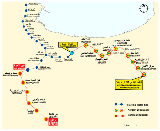
Figure 1.
Algiers metro line: operational and under construction. Source: Entreprise Métro d’Alger—edited by author, 2023.
This study considered a catchment area of 600 m, which corresponds to approximately a ten-minute walking distance. This information is based on previous research conducted on the city of Algiers [23].
2.2. Methodology
The decision to use the Node–Place Model in this study was based on its proven effectiveness in various urban contexts [6,24]. The model’s dual emphasis on transport accessibility and land use diversity provides a complete framework for comprehending the complex nature of urban development surrounding metro stations.
Alternative models, such as the TOD Index [25] and the Place-Making Index [26], have also been applied in TOD research. The TOD Index incorporates multiple aspects of transit-oriented development (TOD), including density, diversity, design, destination accessibility, distance to transit, and demand management. Similarly, the Place-Making Index emphasizes the creation of vibrant public spaces and the enhancement of local community interactions. However, these models often require extensive datasets and complex computations, which may not be practical in all urban contexts, particularly those with limited data availability.
In contrast, the simplicity and versatility of the Node–Place Model make it particularly suitable for our research of Algiers’ metro stations. This model relies on easily measurable indicators, which is advantageous in contexts where data may be scarce or inconsistent [27]. The model is represented in a diagram with dual axis, consisting of node and place indices. The node index evaluates the connectivity and accessibility of each station, considering factors such as the number of transit lines, frequency of services, and intermodal connections. The place index, on the other hand, assesses the surrounding environment of each station, including land use diversity, density, and the presence of amenities and services. There are five distinct types of station areas distinguished based on their relative positions on the node and place scale.
As shown in Figure 2, balanced areas are situated along the central axis where node and place values are relatively equivalent, reflecting the interplay between transportation and land use dynamics. Stressed areas, represented at the top of the line, exhibit maximum values for both interactions. At the lower end of the line are dependent areas, characterized by limited physical human interaction and a low level of activity intensity and diversity. In the upper left corner of the diagram, unbalanced nodes indicate regions where the transportation dynamic has a greater influence than the land use dynamic. Conversely, in the lower right section of the diagram, unbalanced places indicate regions where the range of activities is significantly higher than the capacity for physical human interaction.
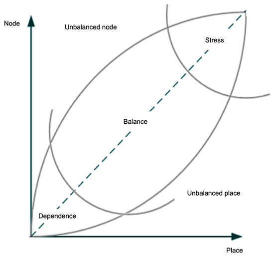
Figure 2.
The Node–Place Model. Source: Bertolini (1999) [6].
The methodology proposed in Bertolini’s original Node–Place Model (1999) [6] was adapted based on the data collected from our fieldwork in Algiers. During our investigation, the COVID-19 pandemic and concurrent political issues in Algeria significantly restricted data availability. These circumstances posed a major limitation to this study and necessitated a deviation from methodologies employed by other researchers in different contexts, such as Reusser et al. (2008) [28], Monajem et al. (2015) [27], and Chorus and Bertolini (2011) [24], which often include urban design indices of station areas [29]. To accurately describe the prevailing conditions of the study areas, we adopted a different approach. All data used to measure the node and place indices were collected through direct site surveys conducted by us. We examined each station and its surrounding 600 m radius, assessing on-site conditions and gathering necessary data for the node and place indicators. Figure 3 presents a comprehensive flow chart detailing the systematic steps employed throughout the research process.
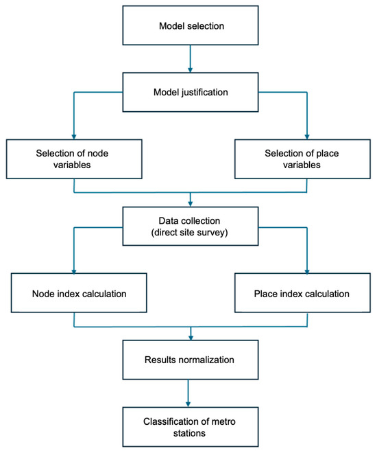
Figure 3.
Flow chart of research process. Source: Authors.
2.3. Data
The selection of node variables was based on the prevalent public transport systems used by the Algerian population to accurately define accessibility to station areas. Certain indicators, such as bike and electric motorbike accessibility, were excluded due to their infrequent use for daily commuting, the lack of bike paths, and the absence of dedicated parking facilities. Additionally, variations in passenger flows between weekdays and weekends, significant in tourist areas, were considered irrelevant as they do not accurately reflect the real context of each station in Algiers. The taxi stop indicator was also omitted because there are no designated taxi areas at metro stations. The prevalence of clandestine taxis and the rising use of competitively priced car-sharing applications have further reduced taxi usage, justifying the exclusion of this indicator. Variables and indicators deemed essential for calculating the node index are outlined in Table 1.

Table 1.
Variables and indicators employed for the node index. Source: Authors, 2021.
The place index incorporates population data, the level of multifunctionality, and the workforce, assessed across four economic clusters. All businesses near each metro station were uniformly measured by the number of establishments in each economic sector, as square meters data per establishment were unavailable. The trade sector was chosen for consistent assessment across all station areas due to its ubiquity, making it the most representative economic cluster. Table 2 details the variables, indicators, and the calculation used for determining the place index.
Table 2.
Variables and indicators utilized for the calculation of the place index. Source: Authors, 2021.
The following formula was used to normalize the data:
- X′ is the normalized value;
- X is the original value;
- Xmin is the minimum value of the feature;
- Xmax is the maximum value of the feature.
All the indicators for every node and place variable have been rescaled to a range of 0 to 1, preserving the shape of every variable’s distribution while making them easily compared on the same scale.
Each node variable’s value is determined by adding up all of its rescaled indicators, and the sum is then scaled once more between 0 and 1. The total of all previously calculated rescaled variables will serve as the final node index, and the result will then be scaled once more between 0 and 1. Thus, the station that has the most connectivity and capacity will therefore have a node index of 1, whereas the station with the least connectivity and capacity will have a node index of 0.
To ensure comparability of all indicators related to the workforce variable, they needed to be translated into employee counts. Since there were no adequate international average densities for this purpose, it was required to carry out on-site surveys and measurements to calculate the average workforce count for every indication. Within a 600 m radius of each metro station, we calculated the number of workers for each indicator (street vendors, small family business, big business, street markets, and shopping centers). After determining the number of employees of each indicator, they were rescaled and then summed to have the workforce variables; the result was also rescaled from 0 to 1.
Each station area’s population was rescaled between 0 and 1, and the same process was conducted to calculate the functional mix. All the 20 indicators of the economic clusters—retail, hotels and catering (hostels, small hotels, big hotels, street vendors, small family coffee shops/fast-food, big restaurants, small family business, big business, shopping centers, and street markets); education, health and culture (big hospitals, small hospitalary centers, schools and high schools, kindergartens, educational institutes); administration and services (small offices, uses, banks, and other services); industrial and logistic areas—were measured by summing the number of administrative establishments of each indicator, and then rescaling from 0 to 1.
By summing the values of the three variables (workforce, population, and multifunctional mix) and then rescaling from 0 (representing the station with the lowest number of trading activities and diversity) to 1 (representing the station with the highest trading activities), the place index was computed.
3. Results
3.1. Accessibility Indices of Metro Stations in Algiers
Table 3 presents the calculated accessibility indices for metro stations in Algiers. These indices are categorized into three variables: metro accessibility, public transport accessibility, and car accessibility. Each station’s score reflects its relative accessibility in these variables, providing a comprehensive view of how well-connected each location is within the urban transport network.
Table 3.
Results of node variables.
3.2. Socio-Economic Indices of Metro Stations in Algiers
Table 4 presents the place indices for various metro stations in Algiers. These indices are broken down into three dimensions: workforce, population, and multifunctional mix. Each station’s score reflects its relative performance in these areas, providing a comprehensive understanding of the socio-economic characteristics of the locations surrounding the metro stations.
Table 4.
Results of place variables.
3.3. Node–Place Indices of Metro Stations in Algiers
Table 5 presents the results of the node and place indices for various metro stations in Algiers. These indices are crucial for understanding the performance and characteristics of each station within the context of transit-oriented development (TOD). The node index measures the connectivity and accessibility of a station, while the place index assesses the socio-economic activities and functional diversity around the station. Higher values in both indices indicate a more balanced and integrated urban environment, which is essential for sustainable urban development.
Table 5.
Results of place and node indices.
3.4. Metro Stations’ Classification According to the Node–Place Model
Figure 4 illustrates the final classification of metro stations in Algiers based on Luca Bertolini’s Node–Place Model, while Figure 5 display the position of each metro station according to this classification. This model categorizes stations based on their node and place indices, providing a comprehensive overview of their relative performance in terms of transportation connectivity (node value) and socio-economic activity (place value). Each station is plotted on the diagram, revealing distinct patterns and clusters that are crucial for understanding their roles within the urban fabric.
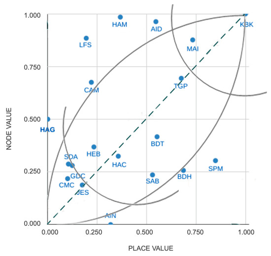
Figure 4.
Diagram of the Node–Place Model in Algiers. Source: Authors, 2023.
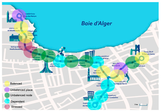
Figure 5.
Classification of station according to the Node–Place Model. Source: Entreprise Métro d’Alger—edited by author, 2023.
Stressed station (11%): At the top of the line, stressed areas indicate stations with extremely high node and place values. These locations exhibit significant economic activity and robust transportation system operations. Both stations are situated in the city center.
Khelifa Boukhalfa (KBK): This station’s high node and place values result from its central location in a dense commercial district with extensive economic activities. The station’s multiple access points, connectivity to numerous bus lines, and proximity to major landmarks like the Missonnier market and Agha station enhance its accessibility and functionality. Future development should focus on maintaining this connectivity and supporting additional commercial growth while ensuring pedestrian safety and comfort.
1er Mai (MAI): This station benefits from high accessibility due to its six access points and numerous bus connections. The presence of a major hospital, markets, and dense street networks further boosts its node and place values. To sustain and enhance its TOD potential, urban planners should aim to improve pedestrian pathways and integrate additional public services and amenities.
Dependent Area (26%): The lowermost part of the line symbolizes places that are reliant, characterized by limited physical human interaction and a modest level of diversity and intensity of activity in the vicinity of these station areas.
Gué de Constantine (GDC): Located in a residential area with limited commercial activities and poor public transport services, GDC exhibits low place values. Despite being close to the highway, it lacks sufficient connectivity. Future efforts should focus on improving public transport links and fostering small-scale commercial activities to enhance the area’s vibrancy.
Jardin d’essais (JES): The sloping topography and the expansive garden limit economic activities around JES. Although periodically crowded, the station lacks consistent high activity levels. Enhancing transport links and integrating commercial and recreational activities closer to the station could boost its place value.
Les Ateliers station (SDA): Surrounded by technical buildings and limited residential areas, SDA has a modest node value. The proximity of railway lines further restricts development. To improve its TOD potential, efforts should focus on diversifying land use around the station and enhancing transport connectivity.
Mer et Soleil (CMS): This primarily residential area with challenging topography exhibits low ease of mobility. Enhancing public transport services and creating pedestrian-friendly pathways could improve its connectivity and place value.
Ain Naadja (AIN): Despite good car accessibility, AIN suffers from low public transport connectivity and minimal economic activities. Future development should focus on enhancing public transport services and supporting local businesses to increase the area’s dynamism.
Unbalanced nodes (26%): Station areas that have modest land use activity but high node values that provide great travel possibilities are Les Fusiliers (LFS), El Harrach Gare (HAG), Hamma (HAM), Aissat Idir (AID), and Amirouche (CAM).
Les Fusillés (LFS): As a multimodal transport hub with high accessibility, LFS has significant potential for TOD. However, its development has been skewed towards administrative functions. Encouraging mixed-use development and improving commercial activities could enhance its place value.
El Harrach Gare (HAG): This station’s excellent connectivity contrasts with its modest economic activities. Promoting functional mix and encouraging commercial development could leverage its high node value.
Hamma (HAM) and Aissat Idir (AID): Located in a historically industrial area undergoing residential development, these stations have potential for TOD. Utilizing industrial wastelands for mixed-use developments and improving transport links could enhance their attractiveness.
Amirouche (CAM): With moderate urban density and business activity, CAM benefits from good connectivity. Future efforts should focus on enhancing public transport and supporting economic activities to boost its place value.
Unbalanced places (11%): Areas with a high rate of place function development and a range of activities, but a minimal capacity for physical human connection, include Place des Martyrs (SPM) and Bachdjarah (BDH).
Place des Martyrs (SPM): This historically and commercially significant area has limited capacity for physical expansion due to its dense urban fabric and historical constraints. Improving traffic management and enhancing pedestrian infrastructure could support its TOD potential.
Bachdjarah (BDH): Despite high place values from nearby shopping centers, BDH has limited public transport. Enhancing transport connectivity and supporting diverse economic activities could improve its node value.
Balanced area (26%): The diagonal through the center has balanced portions. These places are easily accessible, have a good concentration of people and activities, and offer potential for future growth. The node and the place values of Tafourah (TGP), Ali Boumendjel (SAB), and Hai el Badr (HEB) are less than average, but that does not prevent them from being well-balanced, with good connectivity, and relatively high activities.
Tafourah (TGP): Located in a vibrant area with significant commercial and administrative activities, TGP has balanced node and place values. Supporting mixed-use developments and improving pedestrian infrastructure could further enhance its TOD potential.
Bachdjarah Tennis (BDT): The lively environment created by the shopping center and tennis club, combined with good bus connectivity, makes BDT a balanced area. Future efforts should focus on maintaining this balance while promoting additional economic activities.
Ali Boumendjel (SAB): With a variety of businesses and services, SAB benefits from its proximity to a train station. Supporting mixed-use developments and enhancing transport links could further boost its TOD potential.
Hai el Badr (HEB): This station’s strategic location as a metro line interchange and its surrounding economic development makes it a well-balanced area. Enhancing transport connectivity and supporting commercial growth could sustain its TOD potential.
El Harrach Centre (HAC): With high residential density and commercial streets, HAC benefits from excellent transport connectivity. Future development should focus on enhancing public transport services and supporting diverse economic activities to maintain its balance.
4. Discussion and Conclusions
This research aimed to adapt the Node–Place Model to the Algiers context, assessing the metro network’s accessibility and its potential for transit-oriented development (TOD). By analyzing the accessibility and place values of operational metro stations and collecting field data, areas with high TOD potential and those requiring targeted investments for improved connectivity were identified. This study’s achievements include the successful application of the Node–Place Model in a developing country context, providing valuable insights into Algiers’ urban transport dynamics. However, challenges included limited availability of official data and administrative rigidity.
The findings highlight significant disparities in accessibility across Algiers’ metro network. Stations such as Aissat Idir and Hamma, with high public transport and metro accessibility, show promise for TOD initiatives, supporting higher-density developments and multimodal integration to promote sustainable urban growth. Efficient public transportation systems are crucial for TOD success, as inadequate transit service or connectivity can impede TOD objectives [31]. Suburban stations exhibit lower place indices compared to central stations like Tafourah (TGP), Khelifa Boukhalfa (KBK), and 1er Mai (MAI), reflecting Algiers’ monocentric urban structure. This aligns with findings from Lisbon, where central subway stations have the highest node, place, and design indices, while peripheral stations are more imbalanced [29]. Excessive focus on density without adequate infrastructure can strain local resources, leading to overcrowding, increased pollution, and reduced quality of life in TOD areas [32]. Stations with low accessibility, such as Ain Naadja and Mer et Soleil, need targeted investments to improve connectivity. Improving links to other transport modes is vital for balanced urban development, promoting pedestrian convenience, safety, and sustainable growth. However, increased attractiveness of TOD areas can raise property values, potentially causing gentrification and displacement of low-income residents if affordable housing measures are not effectively implemented [33].
Our analysis reveals that central metro stations in Algiers, characterized by dense economic activity and significant transit connectivity, offer substantial potential for effective greenhouse gas (GHG) reduction strategies. These include promoting public transportation over private vehicles, improving energy efficiency in station infrastructure, and incorporating renewable energy sources, such as retrofitting stations with solar panels and energy-efficient lighting to reduce their carbon footprint. Furthermore, our examination of land use around metro stations identified existing green spaces, highlighting a concentration of economic activities and public services in the city center, while peripheral areas predominantly feature collective and individual housing. Significant disparities in green space access across Algiers’ neighborhoods emphasize the need to enhance spatial equity, which is less pronounced in developed cities’ studies. Integrating green spaces within urban planning is vital for carbon sequestration, improving air quality, and enhancing urban biodiversity. Expanding green spaces around metro stations serves as natural carbon sinks, offsetting GHG emissions from urban activities [34]. Peripheral stations with lower place values can benefit from green infrastructure investments, enhancing their ecological value and attractiveness for TOD [35].
The application of the Node–Place Model in Algiers has revealed distinct conditions across different station areas, mirroring observations from Ostrava, Czech Republic [36]. Conversely, the model’s application in Tokyo, Japan, demonstrated a well-balanced integration of node and place functions, with most station areas near the central line of the Node–Place Model, indicating minimal ‘unbalanced nodes’ or ‘unbalanced places’ [24] Tokyo’s focus is predominantly on optimizing and fine-tuning its extensive transport networks and urban development due to its high-density urban environment. European cities like Amsterdam and Rotterdam typically deal with mature urban infrastructures and focus on optimizing and regenerating existing urban area. In contrast, Algiers faces the dual challenge of developing new transport infrastructure and enhancing urban amenities amidst rapid urbanization and informal settlements that shape the specific node and place variables and the required intervention strategies. Like in Algiers, balanced stations in Tokyo exhibited higher levels of development and economic activity. While the application of the Node–Place Model in Algiers aligns with the general aim of fostering balanced urban development seen in other cities, the unique challenges, scope, and expected results in Algiers distinguish it from other implementations.
This research contributes to the literature by applying the Node–Place Model in a developing country, specifically Algiers. It provides insights into the accessibility disparities across the metro network and identifies TOD opportunities. This study highlights the need for targeted investments in low-accessibility areas for balanced urban development. Furthermore, it underscores TOD’s potential to contribute to greenhouse gas (GHG) reduction strategies, promote public transportation, and enhance urban biodiversity through green space integration.
Despite offering a comprehensive analysis of metro station areas in Algiers, this study is limited by data availability and administration rigidity. Future research should explore broader TOD-centered urban planning implications, extending the model [29,37,38,39] and examining government policies’ impact on TOD implementation in Algiers, to avoid barriers like zoning restrictions, parking requirements, and bureaucratic hurdles that complicate transit-supportive land uses [40]. Investigating the financial feasibility of TOD projects and the potential for securing funding for infrastructure improvements and affordable housing is also crucial [41]. Moreover, understanding local opposition and effectively engaging with the community can provide insights into overcoming barriers to successful TOD projects. Expanding research to other cities with similar contexts will enhance the findings’ generalizability and support tailored TOD strategies for sustainable urban growth.
In conclusion, implementing TOD in Algiers requires a multifaceted approach, considering each station area’s specific conditions, supporting diverse economic activities, enhancing public transport connectivity, and promoting sustainable urban growth. By incorporating greenhouse gas response and conservation strategies, Algiers can contribute to global efforts to mitigate climate change, promote sustainable urban growth, and enhance the residents’ quality of life. These efforts will help Algiers achieve more resilient and livable urban areas, aligning with global sustainability goals.
Author Contributions
Conceptualization, R.N. and A.O.; methodology, R.N.; software, R.N.; validation, R.N., A.O., M.F. and B.G.; formal analysis, R.N.; investigation, R.N.; resources, R.N.; data curation, R.N.; writing—original draft preparation, R.N.; writing—review and editing, R.N., A.O., M.F. and B.G.; visualization, R.N.; supervision, A.O., M.F. and B.G.; project administration, A.O. All authors have read and agreed to the published version of the manuscript.
Funding
This research received no external funding.
Institutional Review Board Statement
Not applicable.
Informed Consent Statement
Not applicable.
Data Availability Statement
Dataset available on request from the authors.
Conflicts of Interest
The authors declare no conflicts of interest.
References
- Nicolas, J.-P.; Pochet, P.; Poimboeuf, H. Mobilité urbaine et développement durable: Quels outils de mesure pour quels enjeux? Les Cah. Sci. Du Transp./Sci. Pap. Transp. 2002, 41, 53–76. [Google Scholar] [CrossRef]
- Morimoto, A. Transportation and land use. In Traffic and Safety Sciences: Interdisciplinary Wisdom of IATSS; International Association of Traffic and Safety Sciences: Tokyo, Japan, 2015; pp. 22–30. [Google Scholar]
- Varlet, J.; Zembri, P.; Dumas, E. Atlas des Transports: Les Paradoxes de la Mise en Réseau du Monde; Editions Autrement: Paris, France, 2010. [Google Scholar]
- Calthorpe, P. The Next American Metropolis: Ecology, Community, and the American Dream; Princeton Architectural Press: Princeton, NJ, USA, 1993. [Google Scholar]
- Ibraeva, A.; Correia, G.H.d.A.; Silva, C.; Antunes, A.P. Transit-oriented development: A review of research achievements and challenges. Transp. Res. Part A Policy Pract. 2020, 132, 110–130. [Google Scholar] [CrossRef]
- Bertolini, L. Spatial development patterns and public transport: The application of an analytical model in the Netherlands. Plan. Pract. Res. 1999, 14, 199–210. [Google Scholar] [CrossRef]
- Vale, D.S. Transit-oriented development, integration of land use and transport, and pedestrian accessibility: Combining node-place model with pedestrian shed ratio to evaluate and classify station areas in Lisbon. J. Transp. Geogr. 2015, 45, 70–80. [Google Scholar] [CrossRef]
- Adad, M.C.; Saouli, Z.; Ladraa, T.; Farhi, A.; Alkama, D. Problématique de la planification des villes, étude critique de l’expérience algérienne. L’aménagement L’architecture L’aube 2013, 21, 27–37. [Google Scholar]
- Kateb, K. Population et organisation de l’espace en Algérie. Espace Géographique 2003, 32, 311–331. [Google Scholar] [CrossRef]
- Alcott, B. Impact caps: Why population, affluence and technology strategies should be abandoned. J. Clean. Prod. 2010, 18, 552–560. [Google Scholar] [CrossRef]
- Baouni, T.; De Oña, R.; Merad, B.; Tahraoui, L.; Machado-León, J.L.; De Oña, J. Analysis of the main service quality dimensions that affect the satisfaction of users of the metropolitan rail public transit services in Algiers. TeMA-J. Land Use Mobil. Environ. 2018, 67–82. [Google Scholar] [CrossRef]
- Hadjiedj, A. Cherif Rahmani, La Croissance urbaine en Algérie. Ann. Géographie 1986, 95, 257–259. [Google Scholar]
- Chadli, M.; Hadjiedj, A. L’apport des petites agglomérations dans la croissance urbaine en Algérie. Cybergeo 2003, 2003. [Google Scholar] [CrossRef]
- Bakour, M.; Baouni, T. Urban sprawl and the dynamics of the Algiers metropolitan area: Should administrative structures be promoted? Cah. Geogr. Que. 2015, 59, 377–406. [Google Scholar] [CrossRef]
- Baouni, T. Le transport dans les stratégies de la planification urbaine de l’agglomération d’Alger. Insaniyat 2009, 44–45, 75–95. [Google Scholar] [CrossRef]
- Hadjiedj, A. Le monocentrisme et les enjeux des distances en Algérie, “de l’échelle majeure à l’échelle mineure”. Rev. CENEAP 2012, 45, 47–57. [Google Scholar]
- Bakour, M.; Baouni, T.; Thévenin, T. La dépendance automobile à Alger: Entre efficacité du système automobile et précarité du système de transport. RTS Rech. Transp. Sécurité 2018, 2018, 26. [Google Scholar] [CrossRef]
- Ramdini, S.; Ahmed Zaid, M.; Bouras, Z. Le processus de régulation du service public local des transports en Algérie au gré des réformes: La problématique du désengagement-réengagement de l’État. Alger. J. Glob. Econ. Policies 2017, 7, 9–44. [Google Scholar] [CrossRef]
- Boubakour, F.; Bencharif, H. Evolution du transport urbain en Algérie: Du mode artisanal à la régulation par l’État. Rev. Géotransports Transp. Développement Territ. 2013, 1–2, 91–104. Available online: www.cnfg.fr (accessed on 29 April 2024).
- Chih-Chibani, A. L’expérience des partenariats public privé (PPP) en Algérie: Aperçu synthétique du cas “Metro d’Alger”. Rev. Réformes Économiques Intégration L’économie Mond. 2013, 7, 171–200. Available online: https://www.asjp.cerist.dz/en/article/47096 (accessed on 29 April 2024).
- Mezoued, A. Le métro d’Alger et l’articulation mobilité, transport et urbanisme. In Collectif, 40 Ans du Métro Bruxellois; Bruxelles Mobilité: Bruxelles, Belgium, 2019; Available online: http://hdl.handle.net/2078.1/216449 (accessed on 29 April 2024).
- de Oña, R.; Machado, J.L.; Baouni, T.; de Oña, J. Understanding transit users in Algiers: Key quality factors at the railway services. In Proceedings of the XII Conference on Transport Engineering 2016, CIT, Valencia, Spain, 7–9 June 2016. [Google Scholar] [CrossRef]
- Machado-León, J.L.; de Oña, R.; Baouni, T.; de Oña, J. Railway transit services in Algiers: Priority improvement actions based on users’ perceptions. Transp. Policy 2017, 53, 175–185. [Google Scholar] [CrossRef]
- Chorus, P.; Bertolini, L. An application of the node place model to explore the spatial development dynamics of station areas in Tokyo. J. Transp. Land Use 2011, 4, 45–58. [Google Scholar]
- Singh, Y.J.; Fard, P.; Zuidgeest, M.; Brussel, M.; van Maarseveen, M. Measuring transit-oriented development: A spatial multi criteria assessment approach for the City Region Arnhem and Nijmegen. J. Transp. Geogr. 2014, 35, 130–143. [Google Scholar] [CrossRef]
- Cervero, R.; Ferrell, C.; Murphy, S. Transit Oriented Developmenty and joint development in the United States: A literature review. TCRP Res. Results Dig. 2002, 52, 1–144. [Google Scholar]
- Monajem, S.; Nosratian, F.E. The evaluation of the spatial integration of station areas via the node place model; an application to subway station areas in Tehran. Transp. Res. Part D Transp. Environ. 2015, 40, 14–27. [Google Scholar] [CrossRef]
- Reusser, D.E.; Loukopoulos, P.; Stauffacher, M.; Scholz, R.W. Classifying railway stations for sustainable transitions—Balancing node and place functions. J. Transp. Geogr. 2008, 16, 191–202. [Google Scholar] [CrossRef]
- Vale, D.S.; Viana, C.M.; Pereira, M. The extended node-place model at the local scale: Evaluating the integration of land use and transport for Lisbon’s subway network. J. Transp. Geogr. 2018, 69, 282–293. [Google Scholar] [CrossRef]
- Papa, E. Urban transformations and rail stations system: The study case of Naples. In Proceedings of the 45th Congress of the European Regional Science Association, Amsterdam, The Netherlands, 23–27 August 2005. [Google Scholar]
- Litman, T. Evaluating Accessibility for Transportation Planning; Victoria Transport Policy Institute: Victoria, BC, Canada, 2012; Available online: https://www.vtpi.org/access.pdf (accessed on 29 April 2024).
- Leinberger, C.B.; Lynch, P. The Option of Urbanism: Investing in a New American Dream; Island Press: Washington, DC, USA, 2014. [Google Scholar]
- Zuk, M.; Bierbaum, A.H.; Chapple, K.; Gorska, K.; Loukaitou-Sideris, A. Gentrification, Displacement, and the Role of Public Investment: A Literature Review. J. Plan. Lit. 2018, 33, 31–44. [Google Scholar] [CrossRef]
- Norton, B.A.; Coutts, A.M.; Livesley, S.J.; Harris, R.J.; Hunter, A.M.; Williams, N.S.G. Planning for cooler cities: A framework to prioritise green infrastructure to mitigate high temperatures in urban landscapes. Landsc. Urban Plan. 2015, 134, 127–138. [Google Scholar] [CrossRef]
- Benedict, M.A.; McMahon, E.T. Green infrastructure: Smart conservation for the 21st century. Renew. Resour. J. 2002, 20, 12–17. [Google Scholar]
- Ivan, I.; Boruta, T.; Horák, J. Evaluation of railway surrounding areas: The case of Ostrava city. In Urban Transport XVIII—Urban Transport and the Environment in the 21st Century; WIT Press: Southampton, UK, 2012; Volume 18, pp. 141–152. [Google Scholar]
- Lyu, G.; Bertolini, L.; Pfeffer, K. Developing a TOD typology for Beijing metro station areas. J. Transp. Geogr. 2016, 55, 40–50. [Google Scholar] [CrossRef]
- Nigro, A.; Bertolini, L.; Moccia, F.D. Land use and public transport integration in small cities and towns: Assessment methodology and application. J. Transp. Geogr. 2019, 74, 110–124. [Google Scholar] [CrossRef]
- Thomas, R.; Bertolini, L. Beyond the case study dilemma in urban planning: Using a meta-matrix to distil critical success factors in transit-oriented development. Urban Policy Res. 2014, 32, 219–237. [Google Scholar] [CrossRef]
- Cervero, R. The Transit Metropolis: A Global Inquiry; Island Press: Washington, DC, USA, 1998. [Google Scholar]
- Ewing, R.; Cervero, R. Travel and the built environment: A meta-analysis. J. Am. Plan. Assoc. 2010, 76, 265–294. [Google Scholar] [CrossRef]


Disclaimer/Publisher’s Note: The statements, opinions and data contained in all publications are solely those of the individual author(s) and contributor(s) and not of MDPI and/or the editor(s). MDPI and/or the editor(s) disclaim responsibility for any injury to people or property resulting from any ideas, methods, instructions or products referred to in the content. |
© 2024 by the authors. Licensee MDPI, Basel, Switzerland. This article is an open access article distributed under the terms and conditions of the Creative Commons Attribution (CC BY) license (https://creativecommons.org/licenses/by/4.0/).