Article

Applicability of a Modified Gash Model for Artificial Forests in the Transitional Zone between the Loess Hilly Region and the Mu Us Sandy Land, China

1
College of Desert Control Science and Engineering, Inner Mongolia Agricultural University, Hohhot 010000, China
2
Ministry of Water Resources Pastoral Area Water Conservancy Science Research Institute, Hohhot 010000, China
3
Inner Mongolia Academy of Forestry Sciences, Hohhot 010000, China
*
Authors to whom correspondence should be addressed.
These authors contributed equally to this work.
Sustainability 2024, 16(19), 8709; https://doi.org/10.3390/su16198709
Submission received: 21 August 2024 / Revised: 3 October 2024 / Accepted: 5 October 2024 / Published: 9 October 2024

Abstract

:
Afforestation in the transitional zone between the loess hilly area and the Mu Us Sandy Land of China has reshaped the landscape and greatly affected eco-hydrological processes. Plantations are crucial for regulating local net rainfall inputs, thus making it necessary to quantify the closure loss of plantation species in drought and semi-arid areas. To quantify and model the canopy interception of these plantations, we conducted rainfall redistribution measurement experiments. Based on this, we used the modified Gash model to simulate their interception losses, and the model applicability across varying rainfall types was further compared and verified. Herein, Caragana korshinskii, Salix psammophila, and Pinus sylvestris plantations in the Kuye River mountain tract were chosen to measure the precipitation distribution from May to October (growing season). The applicability of a modified Gash model for different stands was then evaluated using the assessed data. The results showed that the canopy interception characteristics of each typical plantation were throughfall, interception, and stemflow. The relative error of canopy interception of C. korshinskii simulated by the modified Gash model was 8.79%. The relative error of simulated canopy interception of S. psammophila was 4.19%. The relative error of canopy interception simulation of P. sylvestris was 13.28%, and the modified Gash model had good applicability in the Kuye River Basin. The modified Gash model has the greatest sensitivity to rainfall intensity among the parameters of the C. korshinskii and S. psammophila forest. The sensitivity of P. sylvestris in the modified Gash model is that the canopy cover has the greatest influence, followed by the mean rainfall intensity. Our results provide a scientific basis for the rational use of water resources and vegetation restoration in the transitional zone between the loess hilly region and the Mu Us Sandy Land. This study is of import for the restoration and sustainability of fragile ecosystems in the region.

1. Introduction

The precipitation in arid and semi-arid areas is low, and the frequency of extreme precipitation events has increased due to global climate change [1]. As with most typical landscapes in the dryland ecosystem within the transitional zone between the loess hilly region and the Mu Us Sandy Land, artificial forests play a role in soil and water conservation. Therefore, artificial forests are viewed as ecological barriers in this area [2]. In the past decades, China has implemented the “Grain for Green” project, whereby a large number of drought-tolerant trees and shrubs have been planted in these sensitive transitional zones to reduce soil erosion [3,4]. These efforts have reshaped the landscape of the transitional zone and considerably affected various eco-hydrological processes [4,5], such as evapotranspiration [6], soil moisture dynamics [7], and spatial rainfall distribution [8]. However, the role of these plantations in the regulation of local net rainfall inputs remains unclear, and the understanding of the influence of plantations in the local eco-hydrological cycle is limited. This, consequently, restricts effective water resource utilization and management. Thus, the interception losses of typical plantation species in arid and semi-arid areas must be quantified, compared, and predicted.
The canopy is the first vegetation layer that comes into contact with rainfall. After passing through the canopy, rainfall is allocated to canopy interception, throughfall, and stemflow. Throughfall and stemflow are collectively called net rainfall, which is the main source of soil moisture under a canopy [9]. Although the amount of stemflow is small, it can accumulate as a point source at the base of a plant, forming a “wet island” centered on the trunk [10]. A fraction of rainfall is converted into throughfall and stemflow, and another fraction returns to the atmosphere through evaporation during the rainfall period or after rainfall stops. This process is called canopy interception evaporation. Thus, canopy interception directly affects canopy interception evaporation. Interception directly changes rainfall distribution patterns in the horizontal direction [11] and affects the vertical redistribution of net rainfall [12] and the redistribution of raindrop kinetic energy [13]. Thus, interception affects the amount of water available to plants, as well as understory regeneration and water and nutrient cycling. Additionally, interception hampers the rainfall process, promotes the formation of soil physical crusts under the canopy, alleviates soil erosion, reduces flood peak flow, and prolongs runoff time [14,15,16]. The interception of precipitation is the basis of forest hydrology research [17]. It has important eco-hydrological implications for rainfall redistribution as it affects subsequent hydrological processes, such as infiltration and runoff formation. Forest precipitation interception is essential to the evaluation of the benefits of ecological forestry projects and the formulation of excellent governance models. Therefore, quantifying the elements of rainfall redistribution in forest ecosystems is particularly important for the assessment of regional water yield and water resources [8,9,18]. In-depth analysis of the characteristics and laws of rainfall redistribution for each forest type will enhance our understanding of the eco-hydrological functions of forests for soil and water maintenance and surface runoff reduction. The Gash model is the most widely used model in the semi-empirical and semi-theoretical models. Compared with theoretical and empirical models, semi-theoretical and semi-empirical models simplify the calculations in theoretical models and increase the interception processes not involved in empirical formulas [19]. The modified Gash model is a widely used canopy interception model that is suitable for sparse forest lands. It is applied to the simulation and estimation of long-term canopy interception in many regions [20,21]. The model is suitable for different climates or forests. The modified Gash model improves the study of forest evaporation by improving the boundary conditions [22]. Touba Panahandeh [23] studied seven vegetation types in temperate forests and showed that fir (P. abies) was the best vegetation type for soil and water conservation. They also showed that it was possible using data from a short time-study period to derive eco-hydrological parameters. Zhu [24] et al.’s research in the Mu Us Sandy Land pointed out the percentage of rainfall allocated to stemflow determines the stemflow. Deng pointed out in his study on Pinus sylvestris in a region of NE China that the morbidity of assessed canopy interception (I), Sf, and Tf accounted for 17.2%, 6.0%, and 76.8%. The revised Gash analytical model has good applicability [25]. All studies yielded reasonable simulation outcomes.
Moreover, the rainfall redistribution law of typical plantations in the Kuye River Basin and the parameters suitable for the simulation of canopy interception in this area must be evaluated and identified, respectively. In this study, typical Caragana korshinskii, Salix psammophila, and Pinus sylvestris plantations in the Kuye River Basin were investigated. In particular, the precipitation distribution in the growing season was assessed in situ. Based on the assessment data, the modified Gash model was verified, and the influencing factors of the model were evaluated according to different stand characteristics, so as to adjust the parameters suitable for the Kuye River Basin and lay a foundation for the sustainability of vegetation restoration in the future. The applicability of the modified Gash model was assessed with the assessed data. The main objectives were to (1) quantify and compare the interception losses of three typical plantations and (2) evaluate the characteristics of the modified Gash model in the three typical plantations. The results can support a scientific basis for resource management and afforestation strategies for the three typical plantations in the transitional zone. Research on this system provides insights into hydrological modeling and the quantification of the water budget and canopy interception loss for ecosystems in transition zones or similar arid environments.

2. Materials and Methods

2.1. Overview of the Study Area

A typical artificial forest sample plot near the soil and water conservation monitoring station in the Inner Mongolia section of the Kuye River Basin was selected as the study location. It is located on the Yellow River Basin in the Subulga Town of Yijinhuoluo Banner, Ordos (109° 31′ 30.97″ E, 39° 39′ 2.89″ N) (Figure 1). The landform types of the area are chestnut soil, aeolian sandy soil, Pisha sandstone, and sand-covered hilly and gully areas. The Miaochuan Basin belongs to an arid and semi-arid temperate continental climate. The mean, maximum, and minimum annual rainfall are 358.2 mm, 642.7 mm, and 100.8 mm, respectively, and rainfall is mainly concentrated in June–August [26]. In 2023, rainfall in the growing season occurred 46 times, the total rainfall lasted 185 h, and the total rainfall was 439 mm, which was higher than the annual average rainfall in the growing season. The mean number of annual sunshine hours is 2900. The effective accumulated temperature ≥ 10 °C is 2751.3 °C, and the mean annual evaporation is 2563 mm. The northwest wind dominates the area. The wind force is 5–8.

2.2. Sample Plot Selection

In June 2023, typical C. korshinskii, S. psammophila, and P. sylvestris forests near the contract temple (the name of the river basin) monitoring station in the contract temple basin of the Inner Mongolia section of the Kuye River Basin were selected for measurements. Following this, 20 m × 20 m and 15 m × 15 m sample sections were set up in each forest for the sampling of trees and shrubs, respectively, and the space outside the field was used as a control. The mean tree height, crown width, basal diameter, branch number, and biomass of trees and shrubs were determined with a vegetation survey. For shrubs, the base diameter was taken as the total base diameter obtained by adding the base diameter of all branches on the ground [27]. The characteristics of each stand were investigated and recorded (Table 1), and the average value of each index was calculated. Standard plants were selected according to the average value, and nine standard plant vegetation types were selected from each stand. Field monitoring experiments were carried out from July to October 2023, and a customized rain interception device was installed within the vegetation. After a rainfall event, the throughfall and stemflow under the standard plant interception device were assessed. Ten sets of rainfall interception data were collected during the monitoring period.

2.3. Rainfall Observations outside the Forest

The contract temple soil and water conservation monitoring stations were selected for rainfall measurements outside the forest. The linear distance between the sample plots was less than 10 km, and thus the rainfall assessed at these sample points could represent the rainfall outside the forest. The rainfall was assessed manually and then automatically. Three straight cylinders with a radius of 10 cm were installed in the open space next to the rainfall interception device in each plot. After each rainfall event, the cylinders were weighed and the weight was converted into rainfall (rainfall = 10· V o l u m e /π·Radius2). Rainfall data were automatically collected by the long-term weather station and used as a correction to guarantee the correctness of the assessed rainfall outside the forest. Rainwater collection was performed according to rainfall events, with 6-h rainfall considered a rainfall event [28]. Rainfall was assessed within 30 min after the end of the event. Owing to the influence of meteorological conditions, rainfall at night was calculated according to one rainfall event, and the measurement was completed before sunrise the next day [29].

2.4. Observations of Throughfall inside the Forest

C. korshinskii, S. psammophila, and P. sylvestris plots were selected using a self-made rainfall collection device for the forest throughfall observations (TF, mm). Nine standard plants were sampled from each plot. Within the projection areas of the selected standard plants, 12 self-made rain gauges were placed under each standard plant from the base to the four radiation directions according to the 1/3 crown projection radius, 2/3 crown projection radius, and the outer edge of the crown projection. The height and inner diameter of the rain gage were 40 and 20 cm, respectively, and the bottom was completely sealed. The falling of litter was prevented by cleaning the funnel after each rainfall event. The weight was converted into volume and a unified unit of rainfall (mm) following the rainfall event. A total of 10 rainfall data were collected from July to October 2023. TF was as follows:
T F = 1 n i = 1 n T F i A i
TF: throughfall, mm; TFi: the volume of throughfall in the ith throughfall collector, mm3; Ai: the rain area of the ith throughfall collector, mm2; n: the number of throughfall collectors.

2.5. Observations of Stemflow

Nine standard trees were selected in the plot for stemflow measurements. A polyethylene hose was spirally wound on the trunk, the hose was fixed with iron nails, and the hose and trunk were sealed with glass glue. Figure 2 shows the assessed stemflow after rainfall. The stemflow of a single tree was converted into stemflow at the plot scale using the following formula [30]:
S = N × S a A × 10 3
S: stemflow, mm; N: total trees in the sample plot; Sa: mean stemflow of several standard trees, mL; A: plots (20 m × 20 m and 15 m × 15 m), m2.

2.6. Intercept Calculations

The interception was calculated with the water balance formula as follows:
I = P T F - S,
I: interception, mm; P: rainfall, mm; TF: throughfall, mm; S: stemflow, mm.

2.7. Revised Gash Model

The Gash model and its modified model are typical representatives of semi-theoretical models. The model has a good physical basis, rigorous logical analysis, clear physical meaning, wide coverage, easy parameter determination, and strong practicability. It has become one of the most widely used models for measuring canopy interception [25]. Based on Horton’s [31] interception mechanism, Gash further divided canopy interception into canopy adsorption, trunk adsorption, and additional interception. According to whether rainfall can saturate canopy and trunk adsorption, rainfall is divided into two cases to calculate adsorption amounts and additional interception amounts, respectively. A model for estimating canopy interception in a certain period of time by partial summation is proposed. In this paper, the modified Gash model was used to determine the canopy parameter values of the three stand models, and the water holding capacity of the trunk was analyzed in depth. The simulation effect of the modified Gash model in each plantation was tested, and the accuracy, throughfall, and trunk runoff of the three main stands was improved. It provided a more accurate numerical simulation and theoretical basis for the development of hydrological work. The modified Gash model divides rainfall events into three stages: canopy humidification, canopy saturation, and canopy drying after rainfall stops [22]. The canopy retention was calculated as
I = I c + I s + I w + I a + I t ,
where Ic is evaporation from an unsaturated canopy; Is evaporation from a saturated canopy during rainfall; Iw indicates the wetting up of a canopy; Ia is evaporation after the rainfall has ceased; and It is evaporation from trunks. Table 2 reports the description and calculation method of each component in Formula (4).

2.8. Model Evaluation Standards

The applicability of the model was evaluated by using the R2 and relative error of the linear equation of the assessed and simulated values. Muzylo et al. [32] employed the relative error to rate the model effect as very good (relative error < 1%), fine (1% < relative error < 5%), good (5% < relative error < 10%), general (10% < relative error < 30%), and poor (relative error > 30%). Origin 2021 (OriginLab) was used for linear and nonlinear fitting and mapping.
The relative error is calculated as
M R E = | o b s e r v e d p r e d i c t e d | o b s e r v e d .
Excel 2016 (Microsoft Corp., Redmond, WA, USA) was used for sensitivity analysis using the following six parameters from the Gash model: E _ , mean canopy evaporation rate (mm∙h−1); R _ , mean rainfall intensity during rainfall (mm∙h−1); S, canopy storage capacity (i.e., the intercept of the linear equation between total rainfall and net rainfall) (mm); c, canopy cover; pt, stemflow coefficient; St, trunk storage capacity (i.e., the negative intercept of the equation between stemflow and total rainfall) (mm). The adjustment of each parameter ranged from −50% to +50%, and the adjustment step was 10%. The change range of the adjusted simulated interception compared with the initial simulated interception (i.e., the simulated value of the interception when the parameter adjustment range is 0) was recorded. Origin 2018 was used to visualize the results.

3. Results and Analysis

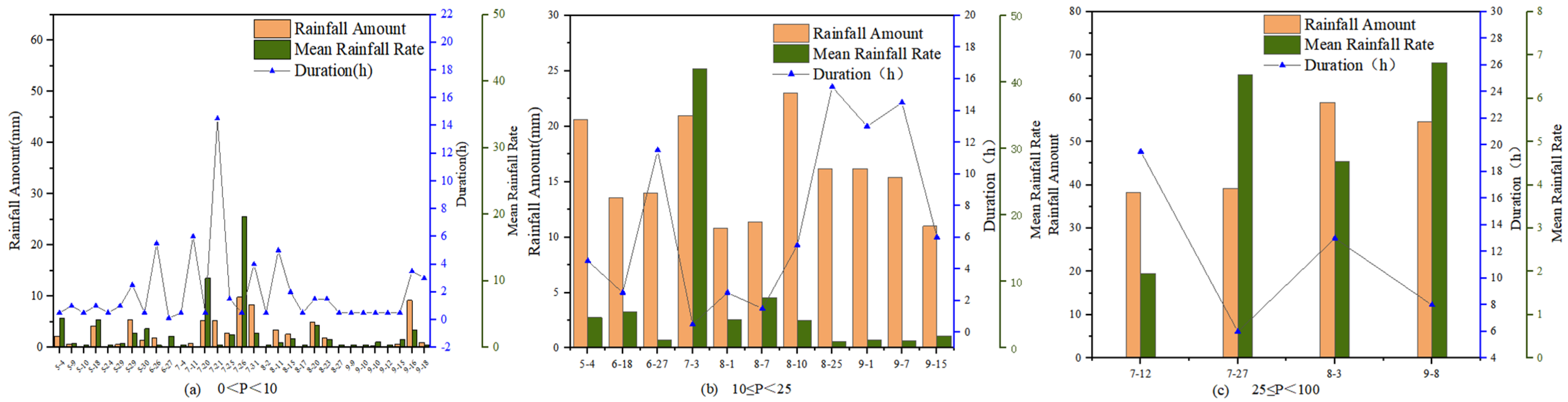
3.1. Rainfall Characteristics

Forty-six rainfalls were monitored in the study area from May to October 2023; the single maximum rainfall was 59 mm (August 3) and the single minimum rainfall was 0.2 mm. According to the rainfall classification in National Standard GB/T 28592-2012 (https://www.nssi.org.cn/nssi/front/78168363.html), rainfall events were mainly light rain events (0 mm < P < 10 mm), and the rainfall frequency was large (31 rainfall events). The total rainfall was determined as 65.2 mm (Figure 2a). However, the cumulative rainfall had a minimal effect on the total rainfall. There were 11 instances of moderate rain with 10 ≤ P < 25, and the total rainfall was 141.8 mm (Figure 2b). There were four instances of heavy rain and rainstorms, and the total rainfall was 191 mm (Figure 2c). Although the rainfall frequency of rainstorms was low, the cumulative rainfall exerted a considerable impact on the total rainfall. The rainfall intensities in this study ranged from 0.4 to 42 mm·h−1, mainly dominated by rainfall events less than 5 mm·h−1.

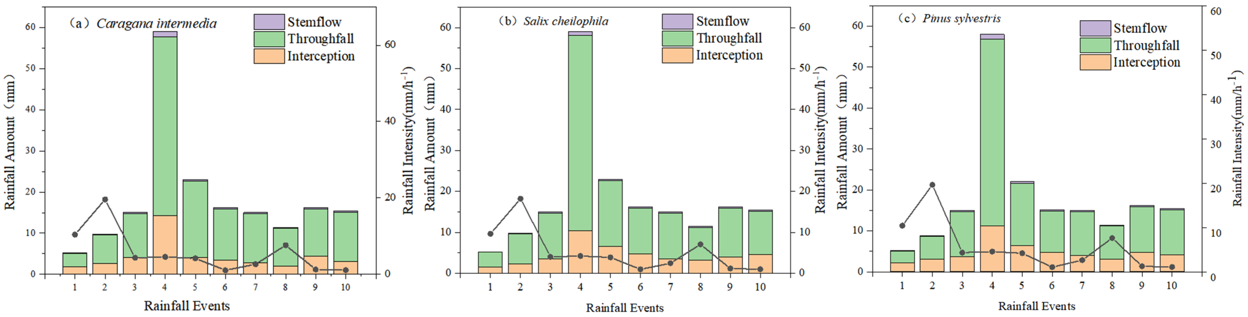
3.2. Interception Characteristics of Typical Plantations

During the monitoring period (Figure 3), the classification of the rainfall redistribution events of the three forest stands exhibited the following trend: throughfall > interception > stemflow. More than half of the rainfall events in the three forests were throughfall. The total throughfall to total rainfall ratios of C. korshinskii, S. psammophila, and P. sylvestris were 74.65%, 72.52%, and 69.96%, respectively. The difference in total throughfall between C. korshinskii and P. sylvestris forests was 8.47 mm. Overall, the ratios of stemflow to total rainfall were small (Figure 4), with values of P.1.85%, C.1.78%, and S.1.65% for P. sylvestris, C. korshinskii, and S. psammophila, respectively. The ratios of canopy interception to rainfall were determined as 28.19% (P. sylvestris), 25.83% (S. psammophila), and 23.57% (C. korshinskii). The total canopy interception amount of the P. sylvestris forest accounted for the highest proportion of the total rainfall, with the total canopy interception amount of the C. korshinskii forest accounting for the lowest proportion of the total rainfall.

3.3. Interception Model Parameters and Simulation Results

3.3.1. Parameters of the Modified Gash Model

Parameter S was taken as the negative intercept of the linear equation of total rainfall and net rainfall (throughfall + stemflow; Figure 5). S was estimated as 1.45 mm (S. psammophila), 0.83 mm (P. sylvestris), and 0.14 mm (C. korshinskii). E ¯ was obtained using the slope of the linear equation of interception and the total rainfall multiplied by R ¯ , with values determined as 1.36 mm·h−1 (C. korshinskii), 1.08 mm·h−1 (P. sylvestris), and 0.91 mm·h−1 (S. psammophila) (Table 3). Table 4 reports the parameters of the modified Gash model.

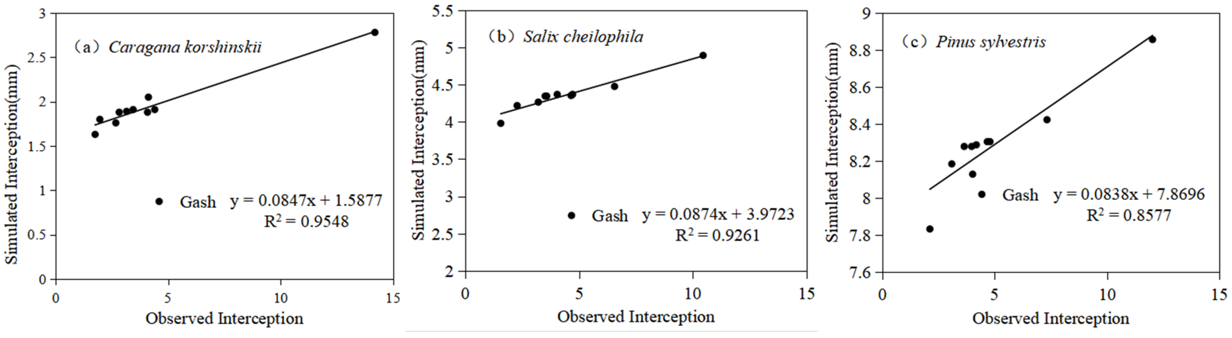
3.3.2. Interception Simulation Results

In the modified Gash model, the simulated values of I, TF, and S of C. korshinskii were 46.43 mm, 142.13 mm, and 1.39 mm, respectively. The assessed value of I was 42.68 mm, and the diversity between the assessed and simulated values of the C. korshinskii I was 3.75 mm, and the relative error was 8.79%. The assessed value of TF is 140.02 mm, and the diversity between the assessed and simulated values was 2.11 mm, and the relative error was 1.51%. The assessed value of S was 3.50 mm, and the diversity between the assessed and simulated values of S was 2.11 mm, and the relative error was 60.27% (Table 4). Evaporation in the saturated canopy during rainfall (Is) was 43.90 mm, accounting for 94.56% of the simulated interception. Evaporation after the cessation of rainfall (Ia) was 1.4 mm, accounting for 3.02% of the simulated interception. Evaporation in the trunk (It) was 0.7 mm after rainfall stopped, accounting for 1.51% of the simulated interception (Figure 6a).
The simulated values of I, TF, and S of S. psammophila were 42.69 mm, 140.60 mm, and 1.03 mm, respectively. The assessed value of I was 44.56 mm, and the diversity between the simulated and assessed values of the S. psammophila I was 1.87 mm, and the relative error was 4.19%. The assessed value of TF is 138.73 mm, and the diversity between the simulated and assessed values was 1.88 mm, and the relative error was 1.35%. The assessed value of S was 2.91 mm, and the diversity between the assessed and simulated values of S was 1.88 mm, and the relative error was 64%. The Is was 26.03 mm, accounting for 61.06% of the simulated interception. The Ia was 14.5 mm, accounting for 34.01% of the simulated interception. The It was 0.2 mm after rainfall stopped, accounting for 0.47% of the simulated canopy interception (Figure 6b).
The simulated values of I, TF, and S of P. sylvestris were 56.47 mm, 135.68 mm, and 0.67 mm, respectively. The assessed value of I was 49.85 mm, and the diversity between the simulated and assessed values of the P. sylvestris I was 6.62 mm, and the relative error was 13.28%. The assessed value of TF was 132.55 mm, and the diversity between the simulated and assessed values was 3.13 mm, and the relative error was 2.36%. The assessed value of S was 3.80 mm, and the diversity between the assessed and simulated values of S was 3.13 mm, and the relative error was 82%. The Is was 24.82 mm, accounting for 43.96% of the simulated interception. The Ia was 14.13 mm, accounting for 25.02% of the simulated interception. The It was 0.18 mm after rainfall stopped, accounting for 0.32% of the simulated interception (Figure 6c).
The modified Gash model was used to determine the ratio of I to rainfall. The results indicate that the modified Gash model was able to successfully simulate the rainfall interception for C. korshinskii, S. psammophila, and P. sylvestris (R2 = 0.95, 0.93, 0.86, respectively; Figure 6).

3.4. Sensitivity Analysis of the Modified Gash Model

The sensitivity analysis of the Gash model showed that the E ¯ , S, c, pt, and St were linearly and positively correlated with interception, while mean rainfall intensity was negatively correlated with interception (Figure 7). When the E ¯ , S, c, pt, and St of the C. korshinskii forest increased by 10%, the interception increased by 9.53%, 0.15%, 10.19%, 0.01%, and 0.15%, respectively. Moreover, the R ¯ value increased by 10%, and the ratio of canopy interception to rainfall decreased by 8.67%. In summary, the sensitivity order of each parameter in the range of −50% to 50% was as follows: R ¯ > c, E ¯ , S, St, and pt. When the E ¯ , S, c, pt, and St values of the S. psammophila forest increased by 10%, the interception increased by 6.52%, 2.98%, 7.22%, 0.02%, and 0.05%, respectively. The R ¯ value increased by 10%, and the ratio of canopy interception to rainfall decreased by 5.93%. In summary, the sensitivity order of each parameter in the range of −50% to 50% was as follows: R ¯  c, E ¯ , S, St, and pt. When the E ¯ , S, c, pt, and St values of the P. sylvestris forest increased by 10%, the interception increased by 8.06%, 2.3%, 20.89%, 0.02%, and 0.05%, respectively. The R ¯ value increased by 10%, and the interception rate decreased by 0.19%. The sensitivity order of each parameter in the range of −50% to 50% was as follows: c, E ¯ , R ¯ , S, St, and pt.

4. Discussion

4.1. Distribution Characteristics of the Hydrological Components of Interception and Their Influencing Factors

Arid and semi-arid regions are vulnerable to climate change [33], which causes ecosystems to experience droughts and water shortages [34]. Climate change will affect the characteristics of rainfall in arid regions and increase the frequency of extremely small rainfall events [34]. Small rainfall events were the most frequent among the rainfall events when measuring the data, but all the rainfall accounted for a small proportion of total rainfall and had a small impact on total rainfall. The quantity, spatial, and temporal distribution of moisture determines the development and growth pattern of vegetation [35]. Rainfall is the main recharge water source in the region. The redistribution characteristics of rainfall by the vegetation canopy directly affect the effective water available to vegetation under a canopy [32]. Changes in rainfall patterns may increase the proportion of interception loss as small rainfall events result in interception loss [8,36]. Therefore, effective rainfall and its spatial distribution in the soil of each artificial forest in this study should be quantified as these parameters offer valuable insights into the regulation of artificial forests and precipitation redistribution. Additionally, they play an important role in the local hydrological cycle in the transitional zone between the loess hilly region and the Mu Us Sandy Land.
After the redistribution of rainfall by the canopy of each plantation during the study period, the observations data show throughfall had the largest proportion, followed by interception and stemflow. The throughfall, stemflow, and interception were 140.02, 3.5, and 42.68 mm (C. korshinskii); 138.73, 2.91, and 44.56 mm (S. psammophila); and 132.55, 3.80, and 49.85 mm (P. sylvestris), respectively. The relationship between throughfall and rainfall may be affected by vegetation types and canopy morphology. This study found that the leaf area of C. korshinskii was considerably smaller than the leaf areas of the other two plantations, and the amount of rainwater intercepted by the leaves was reduced [37,38]. As a consequence, the throughfall rate increased. Vegetation characteristics such as stand density, canopy density, branch roughness, and branch length affect rainfall redistribution. Stand and canopy densities mainly affect throughfall and canopy interception, while branch roughness, branch length, and branch angle mainly affect stemflow [27].
The P. sylvestris forest had the largest stemflow, followed by S. psammophila and C. korshinskii, respectively, which are sparse and exhibit poor growth, a weak interception ability, and large throughfall [37]. P. sylvestris has a considerably smaller angle between its branch and trunk than the other two stands, and the trunk of P. sylvestris is relatively straight and has longitudinal lines, thus effectively collecting and transmitting rainwater and showing a large stemflow rate [39]. The stem runoff rate of C. korshinskii was lower than that of P. sylvestris but higher than that of S. psammophila. The relationship between stemflow and rainfall may be affected by crown width, breast diameter, and the angle between the branch and trunk. When the crown width and breast diameter were the same, the amount of canopy water collected in the trunk and the stemflow decreased as the angle between the branch and trunk increased [40]. Even at a small stemflow rate, rainwater can be collected as a point source and is transported to deep soil for plant roots.
Interception loss, as a net loss item in the process of rainfall redistribution, directly influences the amount of effective rainfall under a canopy [41]. In addition to the influence of meteorological conditions and rainfall characteristics, canopy storage capacity is an important factor affecting interception loss [42]. Canopy storage capacity is usually defined as the minimum rainfall required for the complete wetting of a canopy surface [43]. In our experiment, the P. sylvestris forest showed the strongest interception ability, followed by S. psammophila and C. korshinskii. Interception is affected by the water absorption capacity of leaves. The amount of water absorbed increases with leaf size, with the leaves barely showing saturation and a rise in the canopy interception. The interception loss of C. korshinskii was lower than that of the other two plantations, possibly because of the low canopy, small canopy volume, creeping branches, and small leaves of C. korshinskii. The C. korshinskii shrubland had higher penetration and stemflow rates and a lower interception loss rate than the other plantations. These features promote the conversion of atmospheric rainfall into effective rainfall under a canopy, reduce the net water loss caused by interception loss, and have a substantial impact on local hydrological processes and hydrological cycles in arid areas. Ai et al. [38]. investigated a C. korshinskii shrubland on the Loess Plateau and concluded that the interception of small, short-branched C. korshinskii plants was lower than that of large, long-branched hemispherical C. korshinskii; that is, the level of interception decreased with the crown width and the angle between the branch and trunk. This relationship was observed in the present study. Analysis of variance found the canopy height of P. sylvestris was markedly larger than that of S. psammophila and C. korshinskii (p < 0.05; Table 1), and an increase in interception area increased the storage capacity and promoted evaporation in the canopy [5,8,44]. P. sylvestris has a large canopy height and increased the wet canopy evaporation rate during rainfall [23,45]. In addition, the rough bark surface and needle-like leaves of P. sylvestris can enhance the canopy storage [46].
The amount of net rainfall under the canopy and its spatial distribution determine the spatial distribution pattern of soil moisture under a canopy [35], which in turn has an important impact on the growth and development of vegetation [47]. Therefore, net rainfall is also known as the effective rainfall under the canopy, reflecting the utilization efficiency of rainwater by vegetation [48]. The net rainfalls of C. korshinskii, S. psammophila, and P. sylvestris forests were 143.52, 141.64, and 136.35 mm, accounting for 77.08%, 76.07%, and 73.23% of the total rainfall, respectively. Throughfall, respectively, accounted for 75.20%, 74.51%, and 71.19% of the net rainfall, and the stemflow, respectively, accounted for 1.88%, 1.56%, and 2.04% of the net rainfall. In arid and semi-arid ecosystems, the interception loss in C. korshinskii, S. psammophila, and P. sylvestris was low [49]. The excellent performance in interception loss of these forests reflects the high utilization efficiency of rainfall and explains their dominance among plantation species in the selected test sites.

4.2. Applicability of the Modified Gash Model

The values simulated by the modified Gash model for S. psammophila were lower than the assessed values, as the Gash model assumes that a canopy reaches a completely dry state before each rainfall event. In this study, the time interval between two rainfalls was >6 h. However, in practical applications, especially in arid and semi-arid areas, the temperature difference between day and night in this area is large, while the mean temperature is low. These areas may not fully reach a dry state within 6 h, and thus the canopies are saturated during the next rainfall event. The amount of rainfall was reduced to a certain extent, and the branches, leaves, and other organisms in the canopies absorbed water. However, the modified Gash model cannot simulate water absorption in this manner, resulting in a low simulation value. The simulated values of C. korshinskii and P. sylvestris were higher than the assessed values. This may be attributed to the interception of rainwater by some high stands, which affected throughfall and finally led to the high interception flow rates [50]. In a study on the Moso bamboo forest in Jinyun Mountain, the simulated interception was slightly higher than the assessed value [51]. In the simulation by the Gash model, when the amount of rainfall exceeded the minimum rainfall amount required to saturate the canopy, (PG ≥ P′G), it produced throughfall. However, in actual rainfall events, small rainfall events usually last longer. At the beginning of a rainfall event, a small amount of throughfall is produced and is then accompanied by the whole rainfall process. Thus, simulated interception rates are often large.

4.3. Applicative Prospect

P. sylvestris, S. psammophila and C. korshinskii are a typical species in the “Three North” Project [52]. Song [53] pointed out that the selection of vegetation types is important in the restoration and reconstruction of tree species vegetation. Interception (I) is an essential component of the forest hydrological cycle [54]. Canopy interception thereby influences infiltration [55], erosion [56], soil moisture distribution, subsurface runoff, and flood generation [57], all within climate change [58]. In this manuscript, the sand-fixing afforestation tree species in the Kuye River Basin were analyzed for their canopy interception characteristics. In order to evaluate their canopy interception characteristics, we adopted the most suitable semi-empirical and semi-theoretical model. Although the modified Gash model is currently very mature, due to the location and the complex vegetation types, our research was necessary. Our study is the basis for future research on vegetation restoration and hydrological processes in this area.
In the sensitivity analysis, the parameters that have the greatest influence on the simulation results of the three stands are c, E ¯ , R ¯ , and S. Rainfall intensity had a negative impact on the simulation results while the other parameters exerted a positive impact. This is similar to the results of Li [59]. Limousin [60] and Shi [61] determined c as the most influential parameter. Gao [19] showed that the ratio of the mean evaporation rate to rainfall intensity in Qinghai spruce markedly influenced the simulation results. This difference was attributed to variations in tree species and site conditions. Overall, the modified Gash model produced reasonable simulation results for the interception in C. korshinskii, S. psammophila, and P. sylvestris forests. However, it is necessary to further determine the applicability of the model under these site conditions.

5. Conclusions

The canopy interception characteristics of trees and shrubs in the study area were characterized as throughfall > canopy interception > stemflow. The interception loss rate of P. sylvestris (28.19%) was higher than that of S. psammophila (25.83%) and C. korshinskii (23.57%). This study selected the parameters of the modified Gash model for the region of interest. The relative error of canopy interception of C. korshinskii simulated by the modified Gash model was 8.79%. The relative error of simulated canopy interception of S. psammophila was 4.19%. The relative error of canopy interception simulation of P. sylvestris was 13.28%, and the modified Gash model had good applicability in the Kuye River Basin. The modified Gash model had good applicability in our research areas. This study can provide some insights into the hydrological modeling, water budget, and eco-hydrological processes of typical plantations in the transition zone of the loess hilly region and the Mu Us Sandy Land and quantify the canopy interception loss of ecosystems in arid areas. However, the research scope of this paper is limited. In the future, a number of representative sampling points and more vegetation types along the Kuye River should be selected to optimize the model and further promote the use of the model.

Author Contributions

X.W.: Conceptualization, Formal analysis, Investigation, Methodology, Supervision, Visualization, Writing—original draft, Writing—review and editing. Z.Y.: Investigation, Writing—original draft. J.G.: Data curation, Formal analysis, Investigation, Methodology, Visualization, Writing—original draft. F.Q.: Formal analysis, Investigation, Methodology, Visualization, Writing—original draft. Y.W.: Writing—review and editing. J.N.: Writing—review and editing. All authors have read and agreed to the published version of the manuscript.

Funding

This research was funded by the Inner Mongolia Autonomous Region Science and Technology Plan Project (2022YFHH0106); Inner Mongolia Autonomous Region “Science and Technology to Prosper Mongolia” Action Key Project (2022EEDSKJXM003); Open project of Key Laboratory of Soil and Water Conservation on Loess Plateau, Ministry of Water Resources (WSCLP202302); National Natural Science Foundation project (42307463); the Ordos Water Science and Technology project; and the Evaluation of the Integrated Benefits of Comprehensive Water and Soil Conservation Strategies for the Ecological System in the Key Area Prone to Water and Soil Loss within the Xihedai River Basin.

Institutional Review Board Statement

Not applicable.

Informed Consent Statement

Not applicable.

Data Availability Statement

The original contributions presented in the study are included in the article, further inquiries can be directed to the corresponding authors.

Conflicts of Interest

The authors declare that the research was conducted in the absence of any commercial or financial relationships that could be construed as potential conflicts of interest.

References

  1. Pei, Y.; Huang, L.; Shao, M.; Wang, J.; Zhang, Y. Patterns and drivers of seasonal water sources of artificial sand-fixing plants in the northeastern Mu Us Sandy Land. Pedosphere 2024, 34, 63–77. [Google Scholar] [CrossRef]
  2. Liu, X.; Du, H.; Li, S.; Wang, T.; Fan, Y. Effects of different cropland reclamation periods on soil particle size and nutrients from the perspective of wind erosion in the Mu Us Sandy land. Front. Environ. Sci. 2022, 10, 861273. [Google Scholar] [CrossRef]
  3. Bryan, B.A.; Gao, L.; Ye, Y.; Sun, X.; Connor, J.D.; Crossman, N.D.; Stafford-Smith, M.; Wu, J.; He, C.; Yu, D.; et al. China’s response to a national land-system sustainability emergency. Nature 2018, 559, 193–204. [Google Scholar] [CrossRef]
  4. Zhang, Y.; Wang, X.; Hu, R.; Pan, Y.; Paradeloc, M. Rainfall partitioning into throughfall, stemflow and interception loss by two xerophytic shrubs within a rain-fed re-vegetated desert ecosystem, northwestern China. J. Hydrol. 2015, 527, 1084–1095. [Google Scholar] [CrossRef]
  5. Sadeghi, S.M.M.; Attarod, P.; Van Stan, J.T.; Pypker, T.G. The importance of considering rainfall partitioning in afforestation initiatives in semiarid climates: A comparison of common planted tree species in Tehran, Iran. Sci. Total Environ. 2016, 568, 845–855. [Google Scholar] [CrossRef] [PubMed]
  6. Ji, X.; Zhao, W.; Jin, B.; Liu, J.; Xu, F.; Zhou, H. Seasonal variations in energy exchange and evapotranspiration of an oasis-desert ecotone in an arid region. Hydrol. Process. 2021, 35, e14364. [Google Scholar] [CrossRef]
  7. Wang, X.-P.; Wang, Z.-N.; Berndtsson, R.; Zhang, Y.-F.; Pan, Y.-X. Desert shrub stemflow and its significance in soil moisture replenishment. Hydrol. Earth Syst. Sci. 2011, 15, 561–567. [Google Scholar] [CrossRef]
  8. Zhao, W.; Ji, X.; Jin, B.; Du, Z.; Zhang, J.; Jiao, D.; Zhao, L. Experimental partitioning of rainfall into throughfall, stemflow and interception loss by Haloxylon Ammodendron, a dominant sand-stabilizing shrub in northwestern China. Sci. Total Environ. 2023, 858, 159928. [Google Scholar] [CrossRef]
  9. Lian, X.; Zhao, W.; Gentine, P. Recent global decline in rainfall interception loss due to altered rainfall regimes. Nat. Commun. 2022, 13, 7642. [Google Scholar] [CrossRef]
  10. Levia, D.F.; Frost, E.E. A review and evaluation of stemflow literature in the hydrologic and biogeochemical cycles of forested and agricultural ecosystems. J. Hydrol. 2003, 274, 1–29. [Google Scholar] [CrossRef]
  11. Zhang, Y.; Wang, X.; Hu, R.; Pan, Y. Throughfall and its spatial variability beneath xerophytic shrub canopies within water-limited arid desert ecosystems. J. Hydrol. 2016, 539, 406–416. [Google Scholar] [CrossRef]
  12. Devitt, D.A.; Smith, S.D. Root channel macropores enhance downward movement of water in a Mojave Desert ecosystem. J. Arid Environ. 2002, 50, 99–108. [Google Scholar] [CrossRef]
  13. Kang, W.; Deng, X.; Zhao, Z. Effects of canopy interception on energy conversion processes in a Chinese fir plantation ecosystem. Front. For. China 2008, 3, 264–270. [Google Scholar] [CrossRef]
  14. Li, X.; Niu, J.; Zhang, L.; Xiao, Q.; McPherson, G.E.; Van Doorn, N.; Yu, X.; Xie, B.; Dymond, S.; Li, J.; et al. A study on crown interception with four dominant tree species: A direct measurement. Hydrol. Res. 2016, 47, 857–868. [Google Scholar] [CrossRef]
  15. Newman, B.D.; Wilcox, B.P.; Archer, S.R.; Breshears, D.D.; Dahm, C.N.; Duffy, C.J.; McDowell, N.G.; Phillips, F.M.; Scanlon, B.R.; Vivoni, E.R. Ecohydrology of water-limited environments: A scientific vision. Water Resour. Res. 2006, 42, W06302. [Google Scholar] [CrossRef]
  16. Richardson, D.; Castree, N.; Goodchild, M.F.; Kobayashi, A.; Liu, W.; Marston, R.A. (Eds.) International Encyclopedia of Geography: People, the Earth, Environment and Technology, 1st ed.; Wiley: Hoboken, NJ, USA, 2017. [Google Scholar] [CrossRef]
  17. Wang, Y.; Yu, P. A preliminary study on transformation of rainfall interception models and parameter’s variation. J. Beijing For. Univ. 1998, 6, 29–34. [Google Scholar]
  18. Li, R.; Zheng, H.; O’Connor, P.; Xu, H.; Li, Y.; Lu, F.; Robinson, B.E.; Ouyang, Z.; Hai, Y.; Daily, G.C. Time and space catch up with restoration programs that ignore ecosystem service trade-offs. Sci. Adv. 2021, 7, eabf8650. [Google Scholar] [CrossRef]
  19. Gao, C.; Peng, H.; Zhao, C.; Liu, X. Simulation of rainfall interception of Qinghai spruce (Picea crassifolia) forest in the eastern part of Qilian Mountains by Gash model. Chin. J. Ecol. 2015, 34, 288–294. [Google Scholar] [CrossRef]
  20. Wang, D.; Wang, L.; Zhang, R. Measurement and modeling of canopy interception losses by two differently aged apple orchards in a subhumid region of the Yellow River Basin. Agric. Water Manag. 2022, 269, 107667. [Google Scholar] [CrossRef]
  21. Valente, F.; David, J.S.; Gash, J.H.C. Modelling interception loss for two sparse eucalypt and pine forests in central Portugal using reformulated Rutter and Gash analytical models. J. Hydrol. 1997, 190, 141–162. [Google Scholar] [CrossRef]
  22. Gash, J.H.C.; Lloyd, C.R.; Lachaud, G. Estimating sparse forest rainfall interception with an analytical model. J. Hydrol. 1995, 170, 79–86. [Google Scholar] [CrossRef]
  23. Panahandeh, T.; Attarod, P.; Sadeghi, S.M.M.; Bayramzadeh, V.; Tang, Q.; Liu, X. The performance of the reformulated Gash rainfall interception model in the Hyrcanian temperate forests of northern Iran. J. Hydrol. 2022, 612, 128092. [Google Scholar] [CrossRef]
  24. Zhu, Z.C.; Shao, M.A.; Jia, X.X.; Zhao, C.L. Rainfall partitioning characteristics and simulation of typical shelter forest in Chinese Mu Us Sandy Land. Sci. Total Environ. 2024, 945, 174091. [Google Scholar] [CrossRef] [PubMed]
  25. Deng, J.F.; Yu, Y.F.; Shao, J.; Liu, F.; Li, Z.; Shi, X. Rainfall interception using the revised Gash analytical model for Pinus sylvestris var. mongolica in a semi-humid region of NE China. Ecol. Indic. 2022, 1433, 109399. [Google Scholar] [CrossRef]
  26. Zhang, Y.; Wei, Y.; Liao, Z.; Xu, X.; Han, Z.; Liang, W.; Long, Y.; Guo, J. Determination of soil-groundwater systems recharge mechanism in the middle Inner Mongolia Plateau by isotopic tracers. Environ. Earth Sci. 2020, 79, 473. [Google Scholar] [CrossRef]
  27. Luo, Y.K.; Fang, J.Y.; Hu, H.F. Biomass estimation models and allocation patterns of 14 shrub species in Mountain Luya, Shanxi, China. Chin. J. Plant Ecol. 2017, 41, 115–125. [Google Scholar]
  28. Su, L.; Yang, J.; Zhao, X.; Miao, Y. Effects of fire on interception loss in a coniferous and broadleaved mixed forest. J. Hydrol. 2022, 613, 128425. [Google Scholar] [CrossRef]
  29. Zhang, X.; Zhao, J.; Lei, L.; Wang, D. Characteristics of rainfall redistribution of six shrubs in Eastern Qilian Mountain. Chin. J. Grassl. 2021, 43, 83–89. [Google Scholar] [CrossRef]
  30. Tu, L.; Xiong, W.; Wang, Y.; Yu, P.; Liu, Z.; Han, X.; Yu, Y.; Shi, Z.; Guo, H.; Li, Z.; et al. Integrated effects of rainfall regime and canopy structure on interception loss: A comparative modelling analysis for an artificial larch forest. Ecohydrology 2021, 14, e2283. [Google Scholar] [CrossRef]
  31. Gash, J.H.C. An analytical model of rainfall interception by forests. Quart. J. R. Meteorol. Soc. 1979, 105, 43–55. [Google Scholar] [CrossRef]
  32. Martinez-Meza, E. Stemflow, throughfall and channelization of stemflow by roots in three Chihuahuan Desert shrubs. J. Arid Environ. 1996, 32, 271–287. [Google Scholar] [CrossRef]
  33. Lian, X.; Piao, S.; Chen, A.; Huntingford, C.; Fu, B.; Li LZ, X.; Huang, J.; Sheffield, J.; Berg, A.M.; Keenan, T.F.; et al. Multifaceted characteristics of dryland aridity changes in a warming world. Nat. Rev. Earth Environ. 2021, 2, 232–250. [Google Scholar] [CrossRef]
  34. Ferreira Rodrigues, A.; Rogério De Mello, C.; Nehren, U.; Pedro De Coimbra Ribeiro, J.; Alves Mantovani, V.; Marcio De Mello, J. Modeling canopy interception under drought conditions: The relevance of evaporation and extra sources of energy. J. Environ. Manag. 2021, 292, 112710. [Google Scholar] [CrossRef]
  35. Fathizadeh, O.; Hosseini, S.M.; Zimmermann, A.; Keim, R.F.; Darvishi Boloorani, A. Estimating linkages between forest structural variables and rainfall interception parameters in semi-arid deciduous oak forest stands. Sci. Total Environ. 2017, 601–602, 1824–1837. [Google Scholar] [CrossRef]
  36. Sadeghi, S.M.M.; Attarod, P.; Van Stan, J.T.; Pypker, T.G.; Dunkerley, D. Efficiency of the reformulated Gash’s interception model in semiarid afforestations. Agric. For. Meteorol. 2014, 201, 76–85. [Google Scholar] [CrossRef]
  37. Zhang, Z.S.; Li, X.R.; Dong, X.D.; Jia, X.H.; He, M.Z.; Tan, H.J. Rainfall interception by sand-stabilizing shrubs related to crown structure. Cold Arid Reg. 2009, 1, 107–119. [Google Scholar]
  38. Ai, C.; Gao, G.; Yuan, C.; Tong, J.; Jin, A.; Fu, B. Throughfall and its influential factors of a typical xerophytic shrub (Caragana korshinski) in northern Shaanxi in the Loess Plateau of China. Acta Ecol. Sin. 2018, 38, 6063–6073. [Google Scholar]
  39. Sun, T.M.; Yang, H.; Cao, J.S. Rainfall redistribution of different vegetations in Taihang Mountain, China. Chin. J. EcoAgric. 2023, 31, 1471–1481. [Google Scholar]
  40. Huang, C.B.; Liang, H.W. Stemflow of main forest types in Guangxi subtropics. J. Plant Resour. Environ. 1994, 3, 10–17. [Google Scholar]
  41. David, T.S.; Gash, J.H.C.; Valente, F.; Pereira, J.S.; Ferreira, M.I.; David, J.S. Rainfall interception by an isolated evergreen oak tree in a Mediterranean savannah. Hydrol. Process. 2006, 20, 2713–2726. [Google Scholar] [CrossRef]
  42. David, J.S.; Valente, F.; Gash, J.H. Evaporation of intercepted rainfall. In Encyclopedia of Hydrological Sciences; Anderson, M.G., McDonnell, J.J., Eds.; Wiley: Hoboken, NJ, USA, 2005. [Google Scholar] [CrossRef]
  43. Rutter, A.J.; Kershaw, K.A.; Robins, P.C.; Morton, A.J. A predictive model of rainfall interception in forests, 1. Derivation of the model from observations in a plantation of Corsican pine. Agric. Meteorol. 1971, 9, 367–384. [Google Scholar] [CrossRef]
  44. Su, L.; Zhao, C.; Xu, W.; Xie, Z. Modelling interception loss using the revised Gash model: A case study in a mixed evergreen and deciduous broadleaved forest in China. Ecohydrology 2016, 9, 1580–1589. [Google Scholar] [CrossRef]
  45. Cisneros Vaca, C.; Van Der Tol, C.; Ghimire, C.P. The influence of long-term changes in canopy structure on rainfall interception loss: A case study in Speulderbos, The Netherlands. Hydrol. Earth Syst. Sci. 2018, 22, 3701–3719. [Google Scholar] [CrossRef]
  46. Magliano, P.N.; Whitworth-Hulse, J.I.; Florio, E.L.; Aguirre, E.C.; Blanco, L.J. Interception loss, throughfall and stemflow by Larrea divaricata: The role of rainfall characteristics and plant morphological attributes. Ecol. Res. 2019, 34, 753–764. [Google Scholar] [CrossRef]
  47. Magliano, P.N.; Whitworth-Hulse, J.I.; Baldi, G. Interception, throughfall and stemflow partition in drylands: Global synthesis and meta-analysis. J. Hydrol. 2019, 568, 638–645. [Google Scholar] [CrossRef]
  48. Tian, N.; Gu, J.; Yang, X.; Wang, L.; Wang, X.; Chen, L.; Song, N. Redistribution of rainfall in canopy of Caragana intermedia. Arid Zone Res. 2019, 36, 854–862. [Google Scholar] [CrossRef]
  49. Yang, X.; Chen, L.; Wang, L.; Wang, X.; Gu, J.; Qu, W.; Song, N. Dynamic rainfall-partitioning relationships among throughfall, stemflow, and interception loss by Caragana intermedia. J. Hydrol. 2019, 574, 980–989. [Google Scholar] [CrossRef]
  50. Zhao, Y.; Wang, Y.; Wang, Y.; Liu, N.; Liu, M.; Wu, Y.; Chen, L. Simulation of canopy rainfall interception of the Phyllostachys edulis Forest with the revised gash model in the JinyunMountains of Chongqing. Sci. Silvae Sin. 2011, 47, 15–20. [Google Scholar]
  51. Wang, Y.; Wang, L.; Wei, S. Modeling canopy rainfall interception of a replanted Robinia pseudoacacia forest in the Loess Plateau. Acta Ecol. Sin. 2012, 32, 5445–5453. [Google Scholar] [CrossRef]
  52. Song, L.; Zhu, J.; Li, M.; Yu, Z. Water utilization of Pinus sylvestris var. mongolica in a sparse wood grassland in the semiarid sandy region of Northeast China. Trees 2014, 28, 971–982. [Google Scholar] [CrossRef]
  53. Song, L.; Zhu, J.; Zheng, X.; Wang, K.; Lü, L.I.; Zhang, X.; Hao, G. Transpiration and canopy conductance dynamics of Pinus sylvestris var. mongolica in its natural range and in an introduced region in the sandy plains of Northern China. Agric. For. Meteorol. 2020, 281, 107830. [Google Scholar] [CrossRef]
  54. Price, A.G.; Carlyle-Moses, D.E. Measurement and modelling of growing-season canopy water fluxes in a mature mixed deciduous forest stand, southern Ontario, Canada. Agric. For. Meteorol. 2003, 119, 69–85. [Google Scholar] [CrossRef]
  55. Fleischbein, K.; Wilcke, W.; Goller, R.; Boy, J.; Valarezo, C.; Zech, W.; Knoblich, K. Rainfall interception in a lower montane forest in Ecuador: Effects of canopy properties. Hydrol. Process. 2005, 19, 1355–1371. [Google Scholar] [CrossRef]
  56. Aboal, M.; Jimenez, D.; Morales, J. Hernandez Rainfall interception in laurel forest in the Canary Islands. Agric. For. Meteorol. 1999, 97, 73–86. [Google Scholar] [CrossRef]
  57. Li, Y.; Cai, T.; Man, X.; Sheng, H.; Ju, C. Canopy interception loss in a Pinus sylvestris var. mongolica forest of Northeast China. J. Arid Land 2015, 7, 831–840. [Google Scholar] [CrossRef]
  58. Deng, J.F.; Yao, J.Q.; Zheng, X.; Gao, G.L. Transpiration and canopy stomatal conductance dynamics of Mongolian pine plantations in semiarid deserts, Northern China. Agric. Water Manag. 2021, 249, 106806. [Google Scholar] [CrossRef]
  59. Li, Y.; Ma, R.; Zhang, Y.; Cheng, T.; Li, Z.; Niu, Y. Simulation of canopy rainfall interception of Platycladus orientalis forest and its mixed forest using the modified Gash model. Chin. J. Ecol. 2019, 38, 1331–1338. [Google Scholar] [CrossRef]
  60. Limousin, J.-M.; Rambal, S.; Ourcival, J.-M.; Joffre, R. Modelling rainfall interception in a Mediterranean Quercus ilex ecosystem: Lesson from a throughfall exclusion experiment. J. Hydrol. 2008, 357, 57–66. [Google Scholar] [CrossRef]
  61. Shi, Z.; Wang, Y.; Xu, L.; Xiong, W.; Yu, P.; Guo, H. Rainfall redistribution and its spatial variation in the stand of Pinus armandii in the Liupan Mountains. China. Acta Ecol. Sin. 2009, 29, 76–85. [Google Scholar]
Figure 1. Map of the study area.
Sustainability 16 08709 g001
Figure 2. Rainfall characteristics in the study area during the test period.
Sustainability 16 08709 g002
Figure 3. Individual rainfall amount and associated rainfall intensity during the experimental period for Caragana korshinskii (a), Salix psammophila (b), and Pinus sylvestris (c).
Sustainability 16 08709 g003
Figure 4. Throughfall, stemflow, and interception rates of the three typical vegetation types.
Sustainability 16 08709 g004
Figure 5. Relationship between rainfall amount and net rainfall outside a forest during a typical vegetation experiment.
Sustainability 16 08709 g005
Figure 6. Simulation results of the modified Gash model.
Sustainability 16 08709 g006
Figure 7. Sensitivity analysis of the revised Gash model parameters.
Sustainability 16 08709 g007
Table 1. Characteristics of different types of vegetation in the study area.
ClassVegetationMean Tree
Height (m)
Mean Breast
Diameter (cm)
Mean Base Diameter
(cm)
Mean Crown
Width (m)
Age (a)
ShrubCaragana korshinskii2.9 ± 0.08 b-20.7 ± 0.782.54 ± 0.14 ab13
Salix psammophila3.02 ± 0.27 b-28.66 ± 2.082.32 ± 0.27 b11
ArborPinus sylvestris4.17 ± 0.4 a38 ± 2.05-2.88 ± 0.29 a9
Note: The different lowercase letters in the table indicate the significant difference among the plantations (p < 0.05).
Table 2. Definitions and calculations of each parameter (interception component) of the modified Gash model formula.
Rainfall EventInterception ComponentFormula
m(Ic) Evaporation from an unsaturated canopy I c = c à â j = 1 m P G , j
n(Is) Evaporation from a saturated canopy during rainfall
(Iw) Wetting of the canopy
(Ia) Evaporation after rainfall stops
(It) Evaporation from trunks
I s = c à E c Ì R Ì â j = 1 n ( P G , j â ˆ P G , )
I w = n à c à P G , ⠈ n à c à S c
I a = n à c à S c
I t = q à S t + p t â j = 1 n â ˆ q P G , j
Note: m, frequency of rainfall that is insufficient to saturate the canopy; n, frequency of rainfall that is sufficient to saturate the canopy; q, rainfall frequency that is sufficient to saturate the trunks; c, canopy cover; PG, amount of rainfall that saturates the forest canopy; PG,j, rainfall amount outside the forest for the jth rainfall events, mm; E c Ì , mean evaporation rate per unit cover area during rainfall (mm∙h−1); R Ì , mean rainfall intensity during rainfall (mm∙h−1); S, canopy storage capacity (i.e., the intercept of the linear equation between total rainfall and net rainfall) (mm); Sc, canopy storage capacity per unit cover area; St, trunk storage capacity (i.e., the negative intercept of the equation between stemflow and total rainfall) (mm); Stc, trunk storage capacity per unit cover area; and pt, percentage of rainfall converted into stemflow (i.e., the slope of the linear equation between stemflow and total rainfall).
Table 3. The modified Gash model parameters.
ClassParameter Parameter Value
Caragana korshinskiiCanopy coverc0.56
Mean rainfall intensity (mm∙h−1) R _ 5.66
Canopy storage capacity (mm)S0.14
Canopy storage capacity per unit canopy area (mm)Sc0.25
Mean canopy evaporation rate (mm∙h−1) E _ 1.36
Mean evaporation rate per unit canopy area (mm∙h−1) E _ c2.43
Stemflow coefficientpt0.02
Trunk storage capacity (mm)St0.07
Rainfall that saturates the forest canopy (mm)P′G0.33
Salix psammophilaCanopy coverc0.7
Mean rainfall intensity (mm∙h−1) R _ 5.66
Canopy storage capacity (mm)S1.45
Canopy storage capacity per unit canopy area (mm)Sc2.07
Mean canopy evaporation rate (mm∙h−1) E _ 0.91
Mean evaporation rate per unit canopy area (mm∙h−1) E _ c1.29
Stemflow coefficientpt0.01
Trunk storage capacity (mm)St0.02
Rainfall that saturates the forest canopy (mm)P′G2.35
Pinus sylvestrisCanopy coverc0.57
Mean rainfall intensity (mm∙h−1) R _ 5.66
Canopy storage capacity (mm)S1.57
Canopy storage capacity per unit canopy area (mm)Sc2.75
Mean canopy evaporation rate (mm∙h−1) E _ 1.08
Mean evaporation rate per unit canopy area (mm∙h−1) E _ c1.89
Stemflow coefficientpt0.01
Trunk storage capacity (mm)St0.03
Rainfall that saturates the forest canopy (mm)P′G5.56
Table 4. Statistics of the rainfall characteristics in the study area.
Rainfall ScaleFrequencyCumulative Rainfall
(mm)
Percentage of Total Rainfall
(%)
0 < P < 103065.214.87
10 ≤ P < 259141.832.33
25 ≤ P < 50277.417.65
50 ≤ P < 1002113.625.90
Disclaimer/Publisher’s Note: The statements, opinions and data contained in all publications are solely those of the individual author(s) and contributor(s) and not of MDPI and/or the editor(s). MDPI and/or the editor(s) disclaim responsibility for any injury to people or property resulting from any ideas, methods, instructions or products referred to in the content.

