Abstract
The article defines the morphometric, hydrochemical, and hydrobiological parameters of the Ust-Kamenogorsk reservoir, located on the territory of Ablaketka and the Bukhtarma reservoir, formed in the zone of narrowing of the mountain valley (1960), 12 km below the confluence of the Bukhtarma River with the Irtysh River. When determining deviations in indicators of the reservoirs, data from gauging stations have been taken into account. The purpose of the article is to conduct a comprehensive assessment of the current state of two large reservoirs in the East Kazakhstan region during the specified time period. The novelty of this topic lies in its comprehensive approach to assessing various aspects of the reservoirs’ condition in a specific region over a defined period. This approach enables the identification of current trends and issues and facilitates the proposal of practical measures to address them and enhance water resource management. As a result of this research work, after analyzing changes in indicators, the condition of the reservoirs was determined. During the research work, according to the results of hydrochemical studies, the Bukhtarma reservoir is favorable for the habitat of aquatic organisms, and in the Ust-Kamenogorsk reservoir, a positive change in hydrochemical parameters has been noted compared with 2020. In addition, after analyzing the research indicators, it was proposed to form specially protected areas in the Bukhtarma reservoir, suitable for use in connection with the distribution of valuable fish listed in the Red Book of the Republic of Kazakhstan. When demonstrating the location of gauging stations, methods of remote sensing of the earth and the method of geoinformation mapping were used.
1. Introduction
More than 4000 reservoirs with accumulated fresh water reserves have been built in Kazakhstan. Among the largest reservoirs in Kazakhstan are the following: on the Irtysh River—the Bukhtarma reservoir (East Kazakhstan region), on the Ili River—Kapshagai reservoir (Almaty region), on the Syrdarya River—the Shardara reservoir (North Kazakhstan region), on the Syrdarya River—Koksarai (North Kazakhstan region), on the Yesil River—Sergeev reservoir (North Kazakhstan region), on the Tobol River—Karatomar reservoir (Kostanay region), on the Nura River—Samarkand reservoir (Karaganda region), on the Bogen River—Bogen (South Kazakhstan region), on the Yesil River—Vyacheslav reservoir (Akmola region), on the Koshim River—Kirov (West-Kazakhstan region), on the Nura-Topar River (Sherubay-Nura), (Karaganda region), on the Kengir River—Kengir (Karaganda region), on the Irtysh River—Ust-Kamenogorsk (East Kazakhstan region).
The East Kazakhstan region occupies 10% of the territory of Kazakhstan where 13% of the republic’s population lives. The basis for the development of the region’s economy is the reserves of nonferrous and rare metals of Rudny Altai in combination with the water and hydropower resources of the Irtysh River and its tributaries [1]. On this basis, a powerful mining and metallurgical complex of nonferrous metallurgy in the East Kazakhstan region has been formed. This specialization of the region’s industry is associated not only with the wealth of multicomponent nonferrous metals in the subsoil but also with the presence of an appropriate energy base. A special feature of Soviet Kazakhstan was that its urban population was formed as a result of the selection of qualified personnel from the entire USSR [2]. During the Soviet years, a complex of nonferrous metallurgy enterprises was built here [3].
A number of hydroelectric power stations were built on the Irtysh and its positive industries, producing cheap electricity. The most powerful of them are the Bukhtarma, Shulbinsk, and Ust-Kamenogorsk hydroelectric power stations [4].
Hydroelectric power stations are located on the Ust-Kamenogorsk and Bukhtarma reservoirs, which are important for providing electricity to Kazakhstan due to their technical characteristics and location on the Irtysh and Bukhtarma rivers.
The Ust-Kamenogorsk hydroelectric power station is a dam hydroelectric power station with a hydroelectric power station building near the dam. The installed capacity of the power plant is 367.8 MW, the available capacity is 335 MW, and the projected average annual electricity generation is 1580 million kWh. The pressure structures of the hydroelectric power station form the Ust-Kamenogorsk daily regulation reservoir with an area of 37.9 km2, a total volume of 655 million m3, and a useful volume of 35 million m3, which allows for the daily regulation of flow. The normal pressure level of the reservoir (according to the Baltic height system) is 327.84 m [5]..
The Bukhtarminskaya HPP is a dam hydroelectric power station with a hydroelectric power station building near the dam. The installed capacity of the power plant is 675 MW, and the projected average annual electricity generation is 2344 million kWh. The Bukhtarminskaya HPP is located 15 km below the mouth of the Bukhtarma River, 350 km from the source of the Irtysh River at Lake Zaisan. The backwater created by the Bukhtarminskaya hydroelectric power station dam covers the natural levels of Lake Zaisan by 5–6 m, forming a reservoir with a capacity of 49.6 billion cubic meters. and a mirror area of 5490 square kilometers. The creation of the Bukhtarminskaya HPP solves many issues of energy, transport, and fisheries [6].
These hydroelectric dams not only provide a significant share of the region’s electricity but also contribute to savings in electricity generation costs through the use of renewable energy sources. Regulation of river flow and protection from floods in the spring are also important functions of these hydroelectric power plants in Kazakhstan.
2. Materials and Methods
The main research methods include description, lexico-geographical, comparative geographical, statistical, hydrographic measurements, hydrobiological, hydrochemical methods, cartographic, geographic information (GIS) methods, and analysis using hydrographic surveying of the area [1,7].
Methods can be determined in the hydrographic studies of Zh.D. Dostai and the works of S.K. Alimkulov, A.A. Tursunova, and A.A. Saparova [8].
Reservoir exploration in Eastern Kazakhstan is a complex process that necessitates the application of diverse techniques and methodologies. Below is a comprehensive methodology for conducting such research:
- Primary data collection: Initiation involves gathering fundamental information about the reservoirs, encompassing their geographic location, dimensions, geological structure, climatic conditions, and basic environmental parameters.
- Hydrological surveys: Evaluation of the water regime, encompassing data collection on discharge patterns, water accumulation, and regulatory processes. This includes an examination of hydrological characteristics such as water levels, flows, and inflows.
- Geochemical studies: Analysis of water and sediment chemical compositions to assess pollution levels and substance compositions within reservoirs. This aids in discerning exposure extents to anthropogenic influences like industrial emissions and agricultural activities.
- Ecological surveys: Exploration of biological diversity and ecosystems within reservoirs, including analysis of fish community compositions, macrophytes, and aquatic habitats. This facilitates the assessment of reservoir ecological states and their resilience to human impacts.
- Geotechnical survey: Evaluation of hydraulic structure conditions and stability, such as dams and spillways, ensuring their safe operation.
- Engineering geological studies: Examination of reservoir bed and surrounding geological structures to assess geological processes and potential structural stability threats.
- Monitoring and long-term surveillance: Implementation of regular monitoring systems to track environmental, hydrological, and geochemical changes in reservoirs. This involves longitudinal data collection for trend analysis and predictive modeling.
- Strategic planning and resource management: Development of strategies for sustainable reservoir water resource utilization and protection based on research findings. This includes recommendations for enhancing watershed management practices and minimizing adverse human impacts.
An analysis of the hydrological regime of the Bukhtarma reservoir was carried out based on materials from the Republican State Enterprise Kazhydromet for the period of 2017–2021.
2.1. Morphological Description and Grid of Sampling Stations (Bukhtarma Reservoir)
According to morphometric and hydrological characteristics, the reservoir is divided into three distinct parts: lake–river, mountain-valley–, mountain. The mountainous deepwater part includes the reservoir section from the dam to the Narym extension. It is constrained on the northern side by the spurs of the Altai Mountains, and on the southern side, by the Kalbinsky Mountains [9]. Accordingly, the bed topography and the ruggedness of the banks are complex. The drainage network is developed, and there are about 40 small (11–40 km) mountain springs and rivers [10].
The exception is the Bukhtarma River (398 km), providing about 40% of the annual flow at the site of the Bukhtarma hydroelectric power station dam. The bays are predominantly deepwater and are small in area. In general, the littoral zone in this part of the reservoir is poorly developed: the depth zone up to 4 m isobath is 14% and from 4 to 10 m, 13.5%. The middle-mountain–valley part crosses the mountain steppe and, partly, the desert steppe. Its length, including the Narym expansion, to the conventional border—the Kaznakovskaya crossing, is about 105 km, width 2–9 km, and maximum depth—37 m. The flooded valley, in comparison with the mountain one, is not distinguished by the complexity of the relief, and the coastline is slightly indented. The right bank, bounded by the Narym ridge, is relatively steep, rocky, and pebble-sandy. The left one, adjacent to the spurs of the Kalba Mountains and the sands of the Kyzyl-Kum, is more flat and sandy. Depths along the longitudinal section vary from 37 to 15 m. The depth zone up to 10 m makes up 31% of the total area. The vegetation bordering the reservoir is mostly xerophytic, and the banks are open. The lake–river section is part of the desert steppe zone and includes a section of the reservoir from Cape Korzhun to the Kaznakovskaya crossing. In the lake–river zone, the banks are sloping; in the area of the lower Irtysh, they partially touch the hilly sands of the Kyzyl-Kum and the spurs of the Narym ridge. In the northwest of the Zhaisan Basin, a shallow Torangy Bay is formed, with an area of up to 20 thousand hectares. The full-flowing mountain river Kurchum flows into this zone, which, together with the Bukon River flowing from the left bank, forms the Kurchum- Bukonsky spills, with an area of about 30 thousand hectares [11].
Sampling stations were selected taking into account the area of different parts of the watershed and the presence of production sites, as well as biotope diversity, and are shown in Figure 1. Checkpoint No. 1—Kurshim River mouth, Checkpoint No. 2—Bukon River mouth, Checkpoint No. 3—Torangi, Checkpoint No. 4—Ulken Naryn, Checkpoint No. 5—Kara Zhorga, Checkpoint No. 6—Altayka Village, Checkpoint station No. 7—“Vasilievskaya Pereprava”.
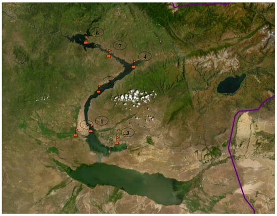
Figure 1.
Observation stations at the Bukhtarma reservoir in 2021 [12].
Hydroposts strategically positioned across the Bukhtarma reservoir were carefully chosen based on the distribution of its different sections, the presence of industrial zones, and the varied biotopes present. This approach enables a comprehensive assessment of hydrochemical parameters and ecological status, considering the diverse influences impacting water resources. Located in Kazakhstan, the Bukhtarma reservoir constitutes a complex ecosystem with a diverse array of biotopes that offer distinct habitats for numerous fish species and other aquatic organisms. For instance, several biotopes can be delineated:
- Mountain streams and lakes: These habitats are inhabited by salmonid fish families (Salmonidae), including trout, salmon, and char, which thrive in cold, transparent waters typical of mountainous rivers and lakes.
- Coastal zones and islands: Various species of carp (Cyprinidae) reside in these areas, such as carp, crucian carp, and other species adapted to a range of aquatic environments, including lakes, rivers, and reservoirs, and capable of adjusting to different levels of salinity and temperature gradients.
- Still waters and thickets: Within such biotopes, fish from the pike family (Esocidae), like pike and minnow, are found. These species favor slow-moving or stagnant waters where they can lie in wait for prey.
- Sediments and river mouths: Catfish (Siluridae), such as catfish, inhabit these environments, preferring deep, slow-moving waters with sediment-laden bottoms where they can seek refuge and forage.
In summary, the diverse biotopes within the Bukhtarma reservoir provide a range of unique conditions suitable for various fish species, thereby contributing to the preservation of biodiversity and the sustainability of aquatic ecosystems in the region.
Ust-Kamenogorsk Reservoir
In the process of writing articles on the status of the Bukhtarma and Ust-Kamenogorsk reservoirs, Google Earth 7.3. and ArcGIS 10.4. software played a pivotal role in data visualization and analysis. The rapid dissemination of Geographic Information Systems (GIS) within society has the potential to enhance the transparency of various hydrological models and to facilitate the transfer of their operations and results to a broad audience of users [13,14].
Google Earth facilitated the initial phase by providing high-resolution satellite imagery, enabling precise determination of the reservoirs’ geographic locations, their surroundings, and ongoing activities. This aspect was crucial for studying landscape, topography, and environmental changes, which are fundamental to understanding ecosystem dynamics within the reservoirs.
ArcGIS, employed for comprehensive geoinformation analysis, enabled the creation and configuration of cartographic materials, including Geographic Information Systems (GIS) that delineated observation points for monitoring reservoir conditions. Significant functionalities in ArcGIS involved the analysis of time-series data on terrestrial water resources, assessments of natural environmental changes, and identification of distributed pollution sources [15].
These software tools significantly enhanced research capabilities by ensuring precise geographic localization and providing analytical insights into the ecological and hydrographic conditions of the Bukhtarma and Ust-Kamenogorsk reservoirs. The utilization of modern technologies such as Google Earth and ArcGIS not only facilitated the visual representation of research findings but also bolstered their scientific rigor and reliability [16,17].
2.2. Morphological Description and Grid of Sampling Stations (Ust-Kamenogorsk Reservoir)
The width of the reservoir is 400–750 m, and the greatest width is 1200 m. The reservoir is deepwater, and the average depth at full design filling is 17 m. The depths in the longitudinal direction of the flooded channel increase from 6 m in the backwater zone to 46 m at the dam [18].
In its configuration, the reservoir is not much different from the expanded channel of the Irtysh River. The banks of the reservoir are steep and composed of rocks, and the littoral zone in the reservoir is almost completely absent.
The bottom of the reservoir is rock and pebble, interspersed with sand and silt deposits; there are large areas with large boulders. Reservoir flow is regulated weekly and daily. The reservoir level is determined by the operating mode of two hydroelectric power stations (Bukhtarma hydroelectric power plant, Ust-Kamenogorsk hydroelectric power plant), and as a result, it is often unpredictable and unstable—even within one day, in some cases, its fluctuations reach 1.0–1.5 m [19].
The Ust-Kamenogorsk reservoir is characterized by high flow with extremely unstable exchange of water masses. Water flow in spring often exceeds 2000 m3/s.
With such an exchange, a complete change of water requires no more than 4–5 days; in the domestic operating mode of the Ust-Kamenogorsk hydroelectric power station, it is 10–12 days. The maximum calculated height of wind waves on the reservoir is 2.2 m [20].
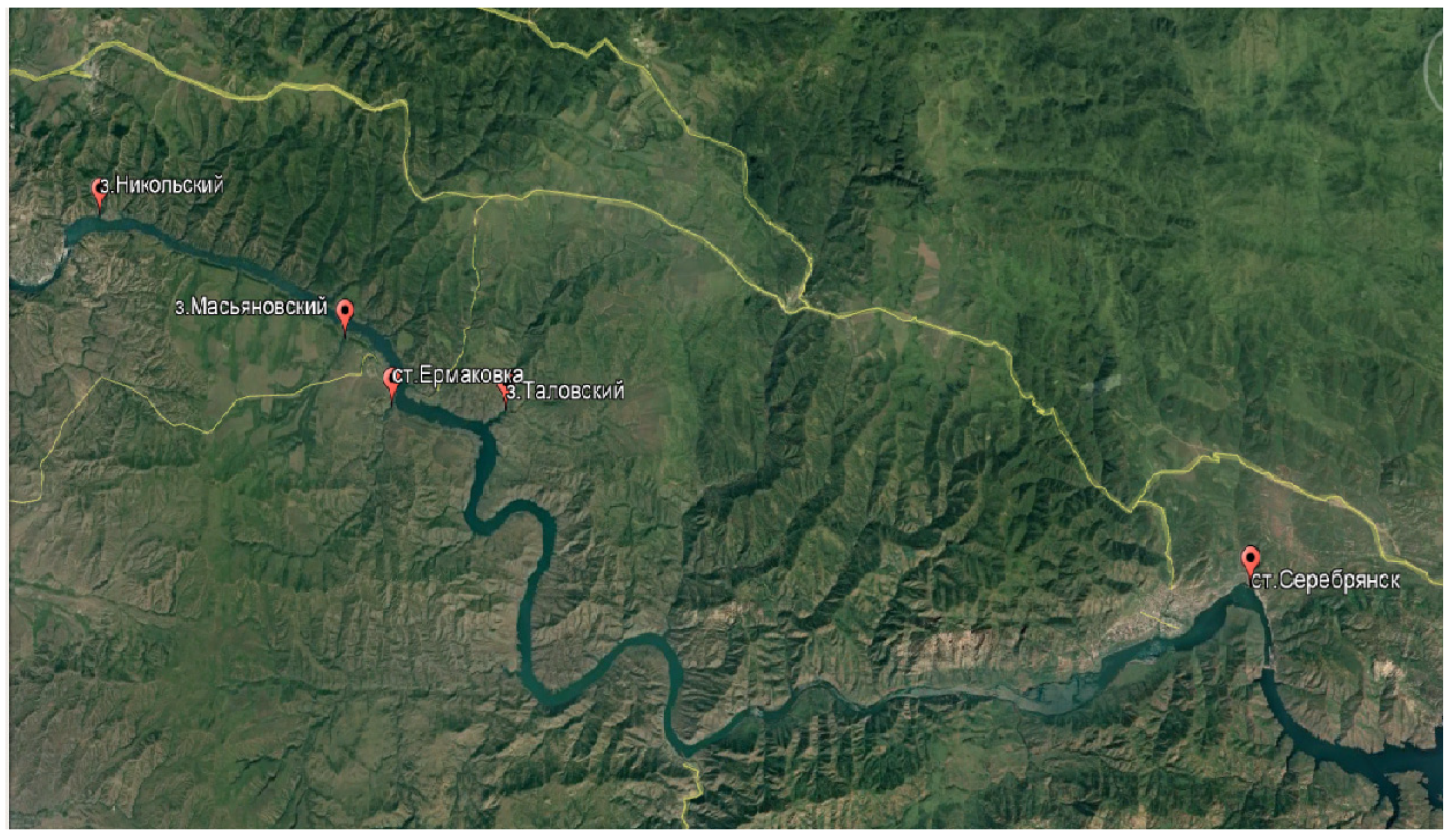
Previously, studies at the reservoir were carried out sporadically, once every 3–4 years. This year, research was carried out at five characteristic stations (Serebryansk, Talovsky, Ermakovka, Masyanovsky, and Nikolsky) (Figure 2).
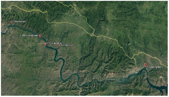
Figure 2.
Layout of stations at the Ust-Kamenogorsk reservoir in 2021 [5].
3. Results and Discussion
3.1. Analysis of the Long-Term and Annual Dynamics of the Hydrological and Hydrochemical Regime of the Bukhtarma Reservoir and Determination of Their Influence on the Formation of Biological Resources
This subsection describes the dynamics of the average annual water level. The level regime of the Bukhtarma reservoir is the same as for Lake Zhaisan and the river part of the reservoir. Hydrologically, this is one body of water, so its level regime was discussed in detail in Section 2.2, together with Lake Zhaisan. There are significant differences in the area and volumes of the lake and river parts of the reservoir. Thus, the area of Lake Zhaisan is twice as large as that of the river part, and the volume of water is twice as large in the river part compared with the lake. The average annual hydrological level of the Bukhtarma reservoir for 9 months of 2021 was 392.29 m according to the Baltic system (mBS), and the areas of the reservoir and Lake Zhaisan were 1536 km2 (Bukhtarma reservoir) and 3217 km2 (Lake Zhaisan), respectively. Reservoir volume in Bukhtarma for 9 months of 2021 reached 23.814 km3, and in Lake Zhaisan, 13.949 km3. In low water years, the shoreline in the reservoir decreases by tens of meters in the lake–river part and by only a few meters in the mountain and mountain–valley parts, while in Lake Zhaisan, by hundreds of meters everywhere [21].
The water level in the reservoir rises in the first half of April, reaching its highest point at the end of July; in September, the reservoir begins to draw down, continuing until the beginning of April. During this time, the level in the reservoir decreases by an average of 0.4–0.65 m; the amplitude of long-term level fluctuations reaches more than 5 m. Fluctuations in the water level in the reservoir depend on the volume of water in the flowing rivers, evaporation, and the volume of reservoir drawdown [22,23]. The hydrological level of the reservoir in 2008–2015 varied significantly from year to year; therefore, taking into account the hydrological characteristics of the reservoir, we can conditionally distinguish the years with low water content—2009 and 2012. The year 2011 belongs to the category of years with average water content, but the years 2010 and 2013, assigned to this group, are at milestone or transitional positions when a sharp change in water content indicators occurs. The years with high water content include 2014–2019 [24]. The level of the normal retaining horizon of the reservoir is 394.94 m according to the Baltic system (mBS). In 2021 the average elevation of the hydrological level for 9 months was 392.29 mBS, which made it possible to create favorable conditions for fish reproduction in the spring of 2020 and was reflected in a fairly good reproduction efficiency and will be considered in more detail in the appropriate section [25].
3.2. Average Monthly and Annual River Flow Volume (Bukhtarma Reservoir)
The Bukhtarma reservoir is a mixed-type reservoir (lake–river) of a complex configuration. Many rivers flow into it. Of these, the largest are the rivers Bukhtarma, Kurchum, Narym, Kaiyndy, Karakol, Bukon, etc. Due to the lack of gauging stations in all rivers, it is not possible to obtain hydrological data and fully describe the volume of river flows [25].
The minimum indicators of the average monthly flow volume were recorded in February when the average monthly value was 1.28 km3 (Figure 3), while the maximum indicator was 1.91 in May. The average annual flow volume of the Bukhtarma reservoir for 9 months of 2021 reached 1.59 km3 [26].
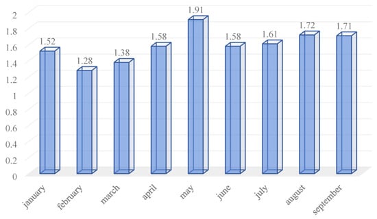
Figure 3.
The volume of flow (km3) in the Bukhtarma reservoir according to average monthly data for 2021 (for 9 months).
Analysis of the runoff data from the Bukhtarma reservoir reveals distinct patterns and underlying reasons for variations in the flow volume across different months. January starts with relatively low runoff, characteristic of winter months marked by minimal rainfall and limited snowfall accumulation. February continues this trend with decreased runoff, owing to insufficient precipitation and minimal snowmelt. March sees a slight increase in runoff, attributed to the onset of spring snowmelt and light rainfall. April experiences a significant rise in runoff as snow begins to melt actively, contributing to increased water flow. May records the peak runoff for the period, driven by ongoing snowmelt and potential spring rains. June shows a decrease in runoff compared with May, influenced by reduced snowmelt and entering the summer period with lower precipitation. July witnesses a slight increase in runoff possibly due to summer rains and heightened runoff from upstream sources. August sees a further increase in runoff, likely influenced by increased precipitation or controlled releases from upstream reservoirs. September maintains high runoff levels due to potential autumn rains and ongoing controlled releases. Factors affecting the runoff volume include snowmelt, which contributes significantly in spring months like April and May, intense precipitation in spring and summer, regulated water releases from upstream spillways, and seasonal variations such as winter frosts and summer droughts. This comprehensive analysis enhances understanding of flow dynamics in the Bukhtarma reservoir and the factors shaping its hydrological regime.
Thus, we can conclude that the average monthly flow volume of the Bukhtarma reservoir in 2021 for 9 months varies widely.
3.3. Description and Condition (Current and Forecast) of the Hydrographic Network of the Bukhtarma Reservoir, as Well as the Role of Floodplain Reservoirs and Other Additional River Systems in Fisheries
The subsidiary system of the Bukhtarma reservoir is represented by full-flowing right tributaries (the Bukhtarma, Narym, and Kurchum rivers) and less full-flowing left tributaries (the Kaiyndy, Karakol, and Bukon rivers) [27].
The right tributaries of the reservoir are mountainous in nature and have little significance in the efficiency of fish reproduction, but they are of great importance for the conservation of biodiversity. The Bukhtarma and Kurchum rivers are reserves for native ichthyofauna, which it is forced out of the reservoir by acclimatizers [28]. These are valuable fish species: common taimen, Siberian grayling, lenok (uskuch), and taimen included in the Red Book of the Republic of Kazakhstan. In the field of fisheries, in the right tributaries of the reservoir, it is necessary to create protected areas for the protection of valuable rare species of fish. In terms of forecasts, the water content of the right tributaries is not threatened if projects to regulate these rivers are not implemented [29,30].
The left tributaries of the Bukhtarma reservoir are short in length and warmer in the lower part, forming spills (for example, Bukonsky spills), which are an important place for the reproduction of fish in the reservoir. River mouths are no-fishing zones. At the mouth of the Bukon River, it is necessary to allocate a particularly valuable area to preserve this zone as it is very important in terms of fish reproduction.
3.4. Content of Dissolved Gases, Biogenic Compounds, Organic Matter, and Water Mineralization by Study Areas
Hydrochemical studies at the Bukhtarma water reservoir were carried out in 2021 in the spring, in May, and in the summer, in August. Samples were collected from the surface layer of the littoral and pelagic zones at seven stations. The analysis was carried out based on the average results of the lake–river (stations—the mouth of the Kurchum River, the mouth of the Bukon River, Torangy Lake), mountain–valley (stations—Bolshenarym Lake, Kara-Dzhorga), and mountain (stations—Altaika village, Vasilyevskaya crossing) parts of the reservoir. The research included the determination of physicochemical properties, gas regime, biogenic compounds, organic matter, and mineralization [30] (Table 1).

Table 1.
Dynamics of average values of the main hydrochemical indicators of the Bukhtarma reservoir in the period of 2017–2021 [21,31].
During the comparative analysis of chemical parameters across various sections of the Bukhtarma reservoir spanning from 2017 to 2021, several significant observations have emerged.
First, examining the pH dynamics reveals uniformly elevated values in 2017, particularly noteworthy in the mountainous sector (10.3), likely attributable to precipitation variations or seasonal water fluctuations. However, subsequent years witnessed a decline in pH levels, potentially linked to anthropogenic impacts such as agro-industrial activities and construction, leading to heightened concentrations of dissolved gases and nutrients.
The variability in dissolved gases (CO2 and O2) also merits attention. In 2017, all sectors exhibited elevated CO2 and O2 levels, possibly due to natural water formation processes or degassing resulting from vigorous biological activity. In later years, specific sectors experienced decreased dissolved oxygen levels, indicative of deteriorating water quality attributable to human influences.
Biogenic compounds (NH4, NO2, NO3, PO4) exhibit distinct trends. Notably, NO3 and PO4 peaked in the lake–river section in 2017, likely indicating anthropogenic contamination from agricultural sources. Conversely, both the mountainous area and Bukhtarma reservoir displayed rising NH4 and NO2 concentrations in recent years, potentially linked to increased nitrogen runoff from agro-industrial regions.
Regarding organic matter and mineralization, significant fluctuations were observed across different sectors. Maximum organic matter levels were documented in 2019, possibly due to increased water body stress from wastewater discharges and pollutants. Although salinity levels generally remained stable within acceptable parameters, recent trends indicate a gradual increase, suggesting the accumulation of salts and minerals within the reservoir.
Consequently, the shifts in the Bukhtarma reservoir’s chemical parameters reflect a blend of natural processes and anthropogenic impacts. The imperative for ongoing systematic monitoring and comprehensive analysis underscores the critical importance of sustainable water management practices and safeguarding reservoir ecosystems as integral components of regional sustainable development initiatives.
The water temperature during the research period in 2021 was 3.0–17.0 °C in May and 21.0–22.5 °C in July. The hydrogen index in 2021 throughout the water body of the reservoir corresponded to the standards for reservoirs of fishery importance, with the limits of fluctuations at sampling stations in the range of 8.0–8.3. According to the pH value of the water, the water in Bukhtarma belongs to the group of weakly alkaline [31].
The average dissolved oxygen content in the reservoir was 8.7 mg/dm3, and the percentage of oxygen saturation was in the range of 90.6%, which characterizes the oxygen regime as favorable for the habitat of aquatic organisms [32].
Carbon dioxide concentration in the Bukhtarma reservoir averaged 0.13 mg/dm3, which correlates with the pH and temperature of the reservoir and was within the established standards for fishery reservoirs.
The content of organic matter (based on permanganate oxidizability) at stations varied in the range of 2.1–2.8 mg O/dm3. According to the average oxidation value (2.4 mg O/dm3), the Bukhtarma reservoir belongs to the category of waters with very low oxidizability [33].
Water hardness in the Bukhtarma water reservoir averaged 3.5 mg-eq/dm3. According to hardness indicators, the surface waters of the Bukhtarma reservoir are classified as soft since the hardness value does not exceed 4 mmol-equiv/dm3.
According to previous studies and the classification of Alekin O.A., the surface waters of the Bukhtarma reservoir belong to the hydrocarbonate class, calcium group, type one, with a predominance of calcium or sodium ions over magnesium.
In 2021, the indicators of the total mineralization of the lake–river part of the reservoir varied between 136 and 157 mg/dm3; for the reservoir as a whole, the mineralization indicator was 145 mg/dm3, which makes it possible to classify the water in the Bukhtarma reservoir as fresh. The content of biogenic compounds did not change significantly compared with previous years. The concentration of ammonium ions in the reservoir as a whole was 0.22 mg/dm3; nitrites, 0.02 mg/dm3; nitrates, 2.01 mg/dm3; and phosphates, 0.14 mg/dm3. The concentration of nutrients did not exceed the established standards for fishery reservoirs [30].
The natural background of pollution of the Bukhtarma reservoir in the Oktyabrsky Reach area is superimposed by pollution from the mining facilities of Kazzinc JSC (Maleevsky, Grekhovsky mines, Zyryanovskaya processing plant, and tailings pond), pollution coming from the inhabited area (Oktyabrsky village and Novaya Bukhtarma village), the Bukhtarma cement company plant, and gas stations, as well as household pollution from a vast recreational area. The treatment facilities of Bukhtarma-Teploenergo LLP and Goluboy Zaliv LLP, located directly on the section of the reservoir coast under consideration, operate efficiently and with a fairly high degree of purification. Treated wastewater is discharged into the reservoir through dispersing outlets. Sources of diffuse pollution are unauthorized dumps of household waste, numerous fragmented pollution instances with light fractions of household waste (plastic bags, bottles, paper, etc.), construction waste, and waste from the construction of houses and recreation centers, as well as the use of organic and mineral fertilizers, various chemicals, and storage of manure in residential areas, resulting in soil and water pollution [29].
Hydrochemical conditions are crucial to shaping the favorable state of the Bukhtarma reservoir, influencing various aspects of its ecosystem and the life of aquatic organisms. One of the critical parameters is water pH, which dictates acidity or alkalinity, impacting mineral dissolution, nutrient availability to flora and fauna, and their physiological functions. Stable pH levels are essential for sustaining healthy fish populations and other aquatic organisms.
The presence of dissolved gases like oxygen and carbon dioxide also plays a pivotal role. Oxygen is vital for aquatic organism respiration; its depletion can lead to water quality decline and potentially mass fish mortality. Elevated carbon dioxide levels can reduce oxygen solubility, further compromising aquatic habitats. Biogenic compounds such as ammonium, nitrites, nitrates, and phosphates are pivotal for water fertility but excessive levels can spur algae proliferation, reducing water clarity and adversely affecting aquatic ecosystems and potability.
Organic matter accumulation in water is significant as it can heighten pollution levels and necessitate intensified water treatment efforts. Water mineralization, denoting the total dissolved mineral content, is also critical. Elevated salinity levels may indicate mineral and salt accumulation, influencing water chemistry and physicochemical properties.
Hence, maintaining the Bukhtarma reservoir’s favorable condition necessitates continuous monitoring of hydrochemical parameters and actions to mitigate anthropogenic impacts, enhance water quality, and safeguard aquatic ecosystem biodiversity.
3.5. Analysis of Long-Term and Intra-Annual Dynamics of Hydrological and Hydrochemical Regimes
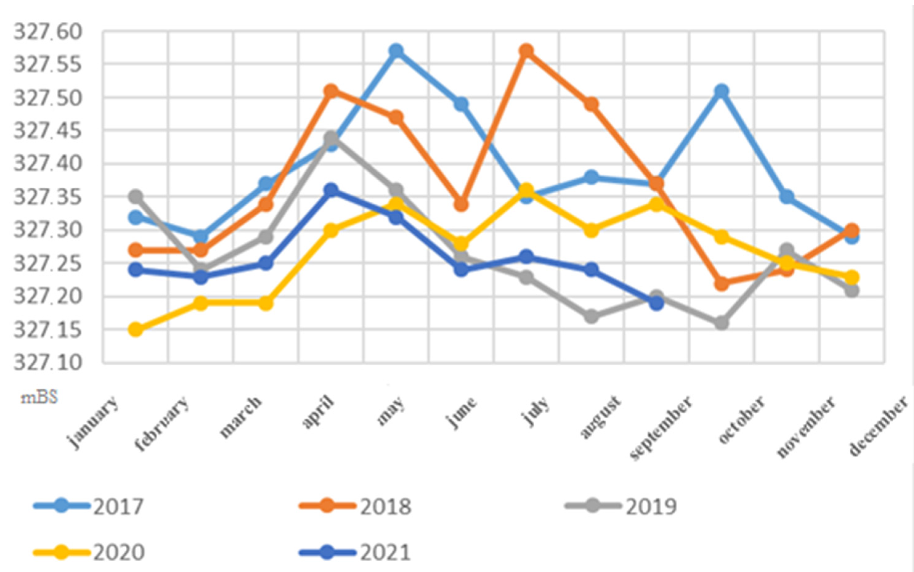
This subsection describes the dynamics of the average annual water level. The level regime of the Ust-Kamenogorsk reservoir is completely artificially regulated, determined by the operating mode of the Bukhtarma and Ust-Kamenogorsk hydroelectric power stations, and as a result, it is often unpredictable and unstable even within one day, in some cases, its fluctuations reach 1.0 m (Figure 4).

Figure 4.
Dynamics of the hydrological water level of the Ust-Kamenogorsk reservoir for 2017–2021 (based on average monthly data).
From 00:00 to 06:00 the reservoir level drops by 0.2–1.0 m, since the operating modes of the two hydroelectric power stations are different; from 06:00 to 24:00 water accumulates. This regime of reservoir drainage has a particularly detrimental effect on fish reproduction since most of the laid eggs dry out and die.
Research work in the Ust-Kamenogorsk reservoir was carried out in 2005, 2006, and 2016–2021. The average annual parameters of the reservoir change little from year to year, for example, in 2017—327.39 m according to the Baltic system (mBS), in 2018—327.37 mBS, in 2019—327.27 mBS, in 2020—327.27 mBS, and in 2021, the average value for 9 months was 327.26 mBS (Hydrological base of Kazakhstan, 2023).
In 2016, the maximum rise in the level of the Ust-Kamenogorsk reservoir occurred on April 24 when the hydrological level of the river increased by 0.35 m according to the Baltic system (mBS) in three days and the value was 327.77 mBS. The minimum indicator was recorded on May 27 and showed a mark of 327.18 mBS, after which the filling of the reservoir began again. The height of the flood wave in 2016 was 0.59 mBS. In 2017, the maximum rise in the level of the Ust-Kamenogorsk reservoir occurred on May 13 when the hydrological level of the river increased per day by 0.52 mBS and reached 327.82 mBS. The minimum level of 327.17 mBS was recorded on June 3, after which the filling of the reservoir began again. The height of the flood wave in 2017 was 0.65 mBS.
In 2018, the rise in the reservoir level began in the first ten days of April, and by the end of the month, the average daily discharge increased by 3.3 times, and the water level reached 327.58 m according to the Baltic system (mBS). The maximum water level for the spring period was recorded on April 28 as 327.79 mBS. In the second ten days of May 2017, the average daily water discharge decreased. The maximum values were recorded on April 25: the average daily water discharge was 1157 m3/s with a water level of 327.58 mBS. By the end of the first ten days of June, a stable hydrological regime was established in the Ust-Kamenogorsk reservoir. In 2019, the rise in the reservoir level began in the second ten days of April at 327.51 mBS, and by the end of the month, the water level reached 327.58 mBS. The maximum water level for the spring period was recorded in the third ten days of April as 327.58 mBS. In the second ten days of May 2018, the average daily water discharge decreased. The maximum values were recorded in the third ten days of April; water discharge in the third ten days amounted to 1070 m3/s with a water level of 327.58 mBS. By the end of the first ten days of June, a stable hydrological regime was established in the Ust-Kamenogorsk reservoir [24].
In 2019, the rise in the reservoir level began in the second ten days of April at 327.32 m according to the Baltic system (mBS), and at the end of the month, the water level was 327.31 mBS. The maximum water level for the spring period was recorded in the first ten days of May as 327.41 mBS.
In the second ten days of May 2019, the average daily water discharge decreased. The maximum values for April were recorded in the second ten days of April (625 m3/s); the water discharge in the third ten days was 589 m3/s with a water level of 327.31 mBS. By the end of the first ten days of June, a stable hydrological regime was established in the Ust-Kamenogorsk reservoir.
In 2020, the rise in the reservoir level began in the second ten days of April at 327.32 mBS, and at the end of the month, the water level was 327.31 mBS. The maximum water level for the spring period was recorded in the first ten days of May as 327.41 mBS. In the second ten days of May 2020, the average daily water discharge decreased. The maximum values for April were recorded in the second ten days of April (732 m3/s); the water discharge in the third ten days was 631 m3/s with a water level of 327.31 mBS. By the end of the first ten days of June, a stable hydrological regime was established in the Ust-Kamenogorsk reservoir.
Having analyzed the data for 9 months of 2021, we observed the following situation: the rise in the water level of the Ust-Kamenogorsk reservoir reached its maximum value in April (327.36). In September, the minimum monthly average water level was recorded in the period under review (for 9 months of 2020), which was 327.19 mBS. The average annual water level according to average monthly data for 2021 (for 9 months) for the Ust-Kamenogorsk reservoir was 327.26 mBS [21].
The Ust-Kamenogorsk reservoir is a striking example of the impact of the hydrological regime on the volume of fish stocks. The characteristics of the reservoir—significant water exchange, cold water, and almost complete absence of a littoral zone—make it unsuitable for creating a high-abundance ichthyofaunistic complex.
3.6. Average Monthly and Annual River Flow Volume (Ust-Kamenogorsk Reservoir)
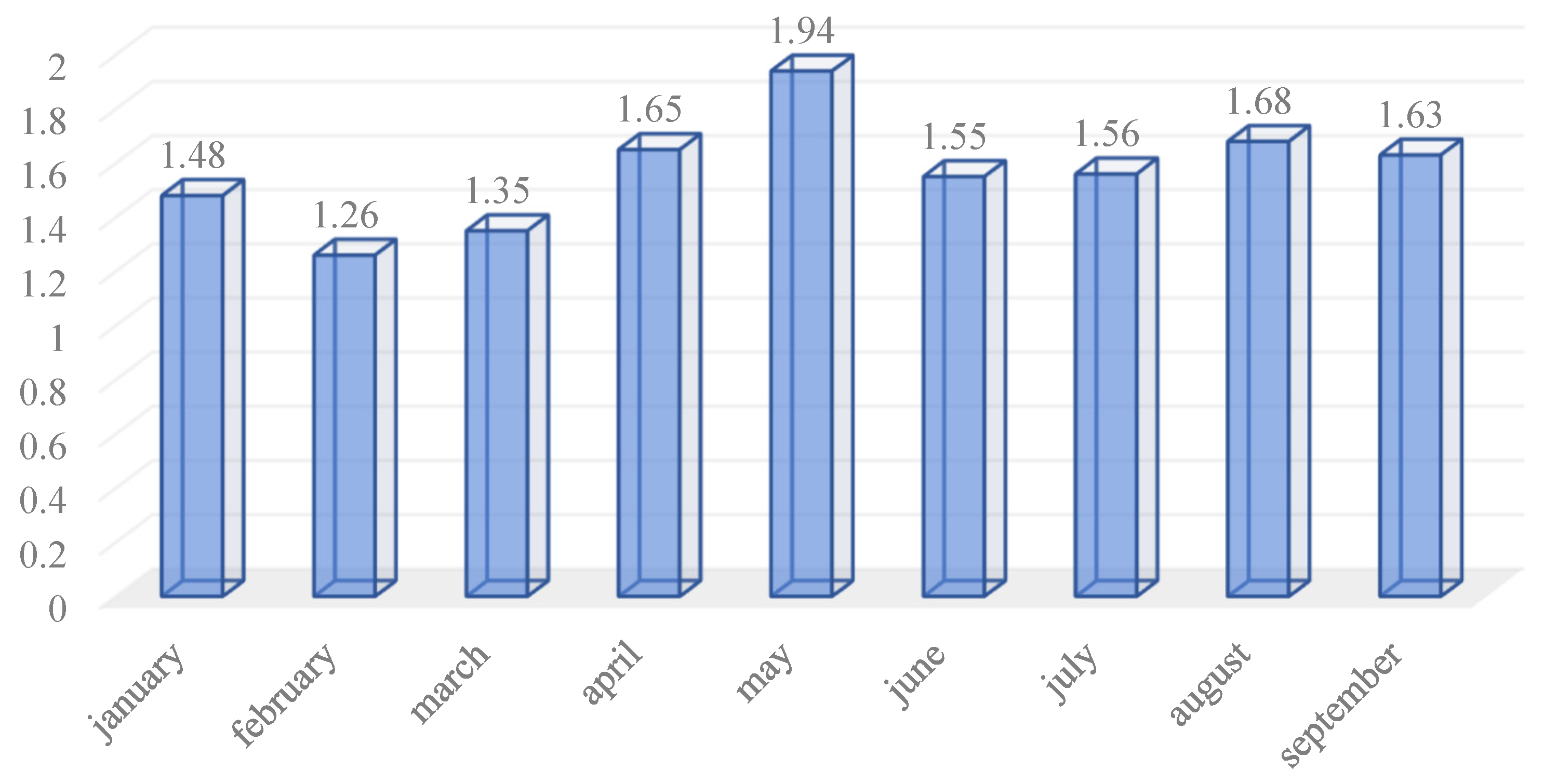
The rivers Guselnichikha, Talovka, and Feklistovka flow into the Ust-Kamenogorsk reservoir. There are no gauging stations in all rivers; therefore, it is not possible to obtain hydrological data and describe the volume of river flow. Based on the available data, it is possible to describe the average monthly and annual flow volume of the Ust-Kamenogorsk reservoir as a whole.
The minimum average monthly runoff volume was recorded in February when the value was 1.26 km3 (Figure 5). The highest figure was recorded in May (1.94 km3).
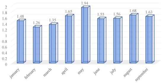
Figure 5.
The volume (km3) of runoff of the Ust-Kamenogorsk reservoir according to average monthly data in 2021 (for 9 months).
The average annual flow volume of the Ust-Kamenogorsk reservoir for 9 months of 2021 was 1.57 km3.
3.7. Description and Condition (Current and Forecast) of the Hydrographic Network of the Ust-Kamenogorsk Reservoir, as Well as the Role of Floodplain Reservoirs and Other Subsidiary River Systems in Fisheries
The hydrographic network of Ust-Kamenogorsk is represented by the main waterways in the form of the mountain rivers Guselnichikha, Talovka, Feklistovka, Tainty, and Ognevka, as well as a small number of mountain streams with small volumes of water masses [34]. The largest rivers have little significance in the efficiency of fish reproduction (grayling, dace, etc.), among which the Tainty River is an important place for fish reproduction in the Ust-Kamenogorsk reservoir [35].
3.8. Content of Dissolved Gases, Biogenic Compounds, Organic Matter, and Water Mineralization by Study Areas
Hydrochemical studies in 2021 at the Ust-Kamenogorsk reservoir were carried out in June and September, and water samples were analyzed to determine physicochemical parameters, gas regime, and biogenic composition. Water samples were taken at five stations: the upper part—Serebryansk; the middle part—Talovka, Ermakovka, and Masyanovka; and the lower part—W. Nikolsky.
During the observation period, the water temperature ranged from 12 to 18.5 °C at the surface and from 8.6 to 10.7 °C at depth. The maximum temperature value (18.5 °C) was observed at the W. Nikolsky station in the surface layer, and the minimum (8.6 °C), in the deep layer at the Serebryansk station [21].
In the last three years, the values of the pH value have been quite stable throughout the entire water area of the reservoir and its average value is pH 8.3 (the water is slightly alkaline). The limit of variation of the indicator is within the range of 7.9–8.8, which corresponds to fishery standards.
In 2021, the content of dissolved oxygen throughout the reservoir varied between 8.5 and 10.6 mg/dm3. The maximum value (10.6 mg/dm3) was recorded in June in the area of the Serebryansk station. The lowest concentrations of dissolved oxygen were noted in the middle part of the reservoir where the average oxygen content for the summer-autumn period was 8.7 mg/dm3. In 2021, there was an improvement in the oxygen regime of the reservoir; the concentration of dissolved oxygen increased by 7.4% compared with 2020 (Table 2) [36].
Table 2.
Dynamics of average values of the main hydrochemical indicators of the Ust-Kamenogorsk reservoir [21].
The carbon dioxide content in the water is insignificant and amounts to 0.12 mg/dm3 on average throughout the entire water area of the reservoir. The highest concentrations of carbon dioxide have been noted in the middle part of the Ust-Kamenogorsk reservoir, with an average value of 0.16 mg/dm3 [18].
In 2021, a slight increase in the content of organic matter (based on permanganate oxidation) was observed at all research stations. The maximum values were recorded in the upper part of the reservoir (3.3 mgO/dm3), and the minimum in the middle part (2.8 mgO/dm3).
During the period from 2017 to 2021, the content of organic matter increased by 55% from 1.4 to 3.1 mgO/dm3, but even with this increase in indicators, the surface waters of the Ust-Kamenogorsk reservoir are characterized by very low oxidizability. The water hardness in the reservoir is 1.3 mg-eq/dm3, which is classified as “very soft” water. The salinity value of the studied waters in 2021 increased noticeably from 108 mg/dm3 in 2020 to 156 mg/dm3 this year and began to correspond to the level of 2018. Mineralization data for 2019–2020 were 50% lower than the current ones. In 2021, the highest mineralization value was noted in the middle part of the reservoir and was 168 mg/dm3. The water of the Ust-Kamenogorsk reservoir is low-mineralized, and according to the classification of O.A. Alekina, it belongs to the hydrocarbonate class with a predominance of calcium and sodium ions over magnesium [23].
The content of nitrogen-containing substances in the water of the Ust-Kamenogorsk reservoir over the past five years has been characterized by concentrations that do not exceed standard values. The ammonia nitrogen content in 2021 varied in the range of 0.18–0.48 mg/dm3. The highest value was noted at the Talovka station. The lowest content of ammonium ions was recorded in the area of the W. Nikolsky station. The average concentration of ammonia nitrogen in the current year was 0.37 mg/dm3 and did not exceed fishery standards. The content of nitrate ions this year increased 15 times from 0.13 mg/dm3 in 2020 to 1.91 mg/dm3 in 2021. The average value was 1.91 mg/dm3, which is higher than the results of 2019 and 2020 but lower than the values of 2017. This year, the average nitrite content showed a value of 0.04 mg/dm3, which also does not exceed the standard values. The concentration of phosphate ions varied within the range of 0.05–0.09 mg/dm3 and, like all nutrients, did not exceed the standards for fishery reservoirs [19].
Following a comparative analysis of chemical parameters across various sections of the Ust-Kamenogorsk reservoir from 2017 to 2021, significant alterations have been identified. Let us examine the dynamics of each parameter.
pH values exhibit relative stability across all sections except the upper part where a notable decline to 7.71 was observed in 2017, likely attributed to changes in precipitation or seasonal fluctuations in water levels. Subsequent years saw an increase in pH within this section, albeit maintaining values below the average of other sections, suggesting potential influences from anthropogenic factors such as industrial emissions and agricultural activities.
Dissolved gases (CO2 and O2) also demonstrate variability. In 2017, all sections displayed elevated levels of CO2 and O2, possibly linked to natural water formation processes or biota-driven gas emissions. However, some sections experienced declining levels of dissolved oxygen in subsequent years, indicating potential deterioration in water quality due to human impacts.
Biogenic compounds (NH4, NO2, NO3, PO4) show diverse trends. For instance, the upper region exhibited high NO3 and PO4 concentrations in 2017, indicating potential agricultural pollution. Conversely, the middle and lower parts and the entire Ust-Kamenogorsk reservoir have shown increased NH4 and NO2 concentrations in recent years, likely stemming from heightened nitrogen runoff originating from agro-industrial areas.
Organic matter and mineralization levels also display notable fluctuations across different sections. Maximum organic matter levels were recorded in 2019, potentially influenced by increased input from wastewater and pollutants. Salinity remains relatively stable within acceptable limits, yet recent trends indicate a tendency toward escalation, possibly indicating the accumulation of salts and minerals within the reservoir.
Thus, shifts in the chemical parameters of the Ust-Kamenogorsk reservoir may arise from a combination of natural processes and anthropogenic influences. The necessity for systematic monitoring and comprehensive analysis underscores the importance of sustainable water management and the safeguarding of aquatic ecosystems as integral components of regional sustainable development initiatives.
The Bukhtarma and Ust-Kamenogorsk reservoirs in Eastern Kazakhstan possess distinctive characteristics concerning their dimensions, hydraulic infrastructure, and socioeconomic significance within the region. Comparable features can be found in other reservoirs worldwide, such as the Cape reservoir and the Aswan reservoir. Comparative analyses of key hydrochemical indicators have been conducted over various periods for both the Bukhtarma and Ust-Kamenogorsk reservoirs, as well as for these international counterparts. Here is a synthesis of findings from such studies:
In the Cape reservoir (Iran):
- -
- Research indicates that the Cape reservoir exhibits elevated concentrations of salts and minerals due to local natural conditions and climatic influences.
- -
- Human activities, notably agriculture and industrial processes, have been identified as significant contributors to pollution levels and alterations in water chemistry.
- -
- Studies reveal that pollution levels fluctuate seasonally alongside changes in water levels and the impact of diverse anthropogenic factors.
In the Aswan reservoir (Egypt):
- -
- Research has identified considerable contamination of the reservoir with heavy metals, pesticides, and other organic pollutants.
- -
- Special emphasis is placed on addressing issues related to sustainable regional development and safeguarding the reservoir’s ecosystems.
- -
- Investigations highlight variations in the hydrochemical composition of water, attributable to both natural phenomena and human activities such as dam construction and agricultural practices.
These findings underscore the critical importance of systematic monitoring and analysis of hydrochemical parameters in reservoirs to ensure their environmental sustainability and the responsible management of water resources within the context of sustainable development goals.
4. Conclusions
According to research conducted in 2021, the Bukhtarma reservoir exhibited favorable oxygen regime characteristics and had a weakly alkaline environment and a normal oxidation level. The amount of biogenic compounds did not exceed regulatory limits. Hydrochemical analysis indicated that the reservoir provides favorable conditions for the habitation of aquatic organisms and is classified as Class I water use.
The analysis of the data yielded the following conclusions:
- Surface waters of the Ust-Kamenogorsk reservoir improved their oxygen regime compared with the previous year.
- The reservoir observed a slight increase in organic substances, a 30% increase in mineralization, and a minor rise in nitrate-ion content. These changes in hydrochemical parameters did not affect water quality or lead to exceeding regulatory standards. As a result, in 2021, the reservoir was also classified as Class I of water use.
- The rise in water level in the Ust-Kamenogorsk reservoir is linked to the operation of hydroelectric power stations, slowing down the formation process of ichthyofauna and resulting in increased fish population.
- Favorable levels of dissolved oxygen and oxygen saturation positively influence the survival of aquatic organisms in the Bukhtarma reservoir.
- Despite the low productivity of fisheries in the Bukhtarma reservoir due to its mountainous nature, biodiversity preservation remains effective. To protect valuable fish species such as taimen, Siberian grayling, and lenok, listed in the Red Book of the Republic of Kazakhstan, the creation of specially protected natural areas in favorable areas of the reservoir is necessary.
The condition of the Bukhtarma reservoir is currently satisfactory, but there is a problem of pollution, so recommendations are needed to reduce and prevent it. Recommendations for reducing pollution in the Bukhtarma reservoir in the Oktyabrsky Reach section:
- Monitoring and control: Strengthen monitoring of the condition of the reservoir, taking into account the influence of pollution from mining sites, a cement plant, gas stations, and household sources. Data updating and analysis must be regular to quickly respond to changes.
- Optimization of treatment facilities: Conduct an audit and modernization of the existing treatment facilities of Bukhtarma-Teploenergo LLP and Blue Bay LLP to increase the efficiency of wastewater treatment before discharge into the reservoir.
- Rehabilitation of landfills and waste management: Organize the reorganization of unauthorized dumps of household and construction waste and intensify control over the storage and disposal of waste, especially in coastal areas and recreational areas.
- Education and awareness: Conduct training programs among local residents, summer residents, and businesses on the importance of environmentally friendly behavior and proper waste management to reduce the impact on the water resources of the reservoir.
- Legislative regulation: Implementation and compliance with strict environmental standards and regulations to prevent pollution from industrial and domestic sources help preserve the water quality and ecosystem of the Bukhtarma reservoir.
The practical significance of the study of hydrographic and biological indicators of the Bukhtarma and Ust-Kamenogorsk reservoirs is to optimize water resources management and improve the ecological state of water bodies. The data obtained will help identify sources of pollution and develop measures to eliminate them. This also helps maintain biodiversity and develop fisheries, increasing economic efficiency. In addition, the results of the study are important for the development of recreational areas and tourism since the cleanliness of water bodies affects their attractiveness. Finally, understanding hydrographic processes and biological changes helps adapt to climate change.
In subsequent studies analyzing the hydrographic and other parameters of the Bukhtarma and Ust-Kamenogorsk reservoirs, it is planned to utilize not only data from local monitoring stations but also the capabilities of remote sensing devices. The objective is to obtain high-resolution satellite images and process them using the ArcGIS 10.4 software suite based on geographic information systems. Additionally, the dynamics of reservoir level changes over the past 10 years will be analyzed using Landsat satellite imagery.
Author Contributions
Conceptualization, N.Z. and K.S.; methodology, A.Y. and K.A.; software, N.A.; validation, S.B. and V.S.; formal analysis, N.K., N.Z. and N.A.; investigation, K.S.; resources, N.K., S.B., V.S. and A.Y.; data curation, N.Z. and E.A.; writing—original draft preparation, N.K. and A.Y.; writing—review and editing, N.Z., N.A., N.K. and K.A.; visualization, N.Z., K.S. and A.Y.; supervision, K.S.; project administration, N.Z.; funding acquisition, N.Z. All authors have read and agreed to the published version of the manuscript.
Funding
This research received no external funding.
Institutional Review Board Statement
Not applicable.
Informed Consent Statement
Not applicable.
Data Availability Statement
The data that support the findings of this study are available upon reasonable request from the authors.
Conflicts of Interest
The authors declare no conflicts of interest.
References
- Zhensikbayeva, N.Z.; Kabdrakhmanova, N.K.; Yeginbayeva, A.Y.; Beisembayeva, R.S.; Amangeldy, N. Assessment of forest fires factors in Eastern Kazakhstan over the last 20 years (2003–2023) using gis technologies. Geoj. Tour. Geosites 2023, XVI, 1803–1811. [Google Scholar] [CrossRef]
- Alekseenko, A.N.; Aubakirova, Z.S.; Dyatlov, V.I. The city in nation-building projects: Soviet autonomy in Siberia and sovereign Kazakhstan. J. Sib. Fed. Univ. Humanit. Soc. Sci. 2022, 15, 204–219. [Google Scholar]
- Alekseenko, A.N.; Aubakirova, Z.S.; Stolyarova, E.O.; Omirzak, T.E. Urban population of modern Kazakhstan: Features of formation and development. Voprosy Istor. 2021, 10, 61–73. [Google Scholar] [CrossRef]
- Bazhenova, O.P.; Barsukova, N.N.; Gulchenko, Y.I. Summer phytoplankton of the Irtysh River in the section Pavlodar (Republic of Kazakhstan)-Omsk (Russian Federation). Bull. Omsk. State Agrar. Univ. 2017, 3, 42–49. [Google Scholar]
- Yegorina, A.V. Physical Geography of Eastern Kazakhstan; Zinchenko, Y.K., Zinchenko, E.S., Eds.; EHI Publishing House: Ust-Kamenogorsk, Kazakhstan, 2002; pp. 30–55. [Google Scholar]
- Burlibayev, M.Z.; Murtazin, Y.Z.; Tursunov, E.A. Rivers’ hydro-chemical regime. In Natural Conditions and Resources; Iskakova, N.A., Medeu, A.R., Eds.; Ministry for Environmental Protection: Almaty, Kazakhstan, 2006; Volume I, pp. 257–263. (In Russian) [Google Scholar]
- Alekin, O.A. Fundamentals of Hydrochemistry; Gidrometeoizdat: Leningrad, Russia, 1970; pp. 55–63. [Google Scholar]
- Dostayuly, Z. General Hydrology; Department of Water Resources: Almaty, Kazakhstan, 2011; p. 280. [Google Scholar]
- Zhensikbayeva, N.; Saparov, K.; Chlachula, J.; Yegorina, A.; Uruzbayeva, N.; Wendt, J. Natural potential for tourism development in Southern Altai (Kazakhstan). Geoj. Tour. Geosites 2018, 21, 200–212. [Google Scholar]
- Dostai, Z.D. Water resources of Kazakhstan: Estimation, Prediction, Management. In Natural Waters of Kazakhstan: Resources, Regime, Quality and Forecast; Institute of Geograph: Almaty, Kazakhstan, 2012; p. 330. [Google Scholar]
- Water Code of the Republic of Kazakhstan Dated 9 July 2003 N 481. Available online: https://ecogosfond.kz/2022/11/28/46898/ (accessed on 28 November 2020).
- Yegorina, A.V.; Loginovskaya, A.N. Ecological aspects of the use of the coastal territory of the Bukhtarma Reservoir. Interexpo Geo Sib. 2015, 4, 227–235. [Google Scholar]
- Sui, D.Z.; Maggio, R.C. Integrating GIS with hydrological modeling: Practices, problems, and prospects. Comput. Environ. Urban Syst. 1999, 23, 33–51. [Google Scholar] [CrossRef]
- Clark, M.J. Putting water in its place: A perspective on GIS in hydrology and water management. Hydrol. Process. 1998, 12, 823–834. [Google Scholar] [CrossRef]
- Formetta, G.; Antonello, A.; Franceschi, S.; David, O.; Rigon, R. Hydrological modelling with components: A GIS-based open-source framework. Environ. Model. Softw. 2014, 55, 190–200. [Google Scholar] [CrossRef]
- Gorelick, N.; Hancher, M.; Dixon, M.; Ilyushchenko, S.; Thau, D.; Moore, R. Google Earth Engine: Planetary-scale geospatial analysis for everyone. Remote Sens. Environ. 2017, 202, 18–27. [Google Scholar] [CrossRef]
- Valadão, L.V.; Cicerelli, R.E.; de Almeida, T.; Ma, J.B.C.; Garnier, J. Reservoir metrics estimated by remote sensors based on the Google Earth Engine platform. Remote Sens. Appl. Soc. Environ. 2021, 24, 100652. [Google Scholar] [CrossRef]
- Kirichenko, O.I.; Anuarbekov, S.M. The state of biodiversity of water bodies of the Irtysh basin and the influence of alien species on the ecosystem. Eurasian Union Sci. 2016, 4, 112–116. [Google Scholar]
- Kulikova, E.V.; Tirskaya, N.A. Peculiarities of accumulation and distribution of heavy metals in organs and tissue of fish Bukhtarma reservoir. Hydrometeorol. Ecol. 2009, 2, 144–152. [Google Scholar]
- Chigrinets, A.G. Water resources of the main tributaries of the Irtysh and the trend of their change. Hydrometeorol. Ecol. 2013, 115–123. [Google Scholar]
- Hydrological Base of Kazakhstan. (Kazhydromet) “Annual Data on the Regime and Resources of Land Surface Waters”. 2023. Available online: http://ecodata.kz:3838/app_hydro/ (accessed on 28 November 2020).
- Abuduwaili, J.; Issanova, G.; Saparov, G.; Abuduwaili, J.; Issanova, G.; Saparov, G. Water resources in Kazakhstan. In Hydrology and Limnology of Central Asia; Springer: Singapore, 2019; pp. 11–46. [Google Scholar]
- Li, M.; Abuduwaili, J.; Liu, W.; Feng, S.; Saparov, G.; Ma, L. Application of geographical detector and geographically weighted regression for assessing landscape ecological risk in the Irtysh River Basin, Central Asia. Ecol. Indic. 2024, 158, 111540. [Google Scholar] [CrossRef]
- Huang, W.; Duan, W.; Nover, D.; Sahu, N.; Chen, Y. An integrated assessment of surface water dynamics in the Irtysh River Basin during 1990–2019 and exploratory factor analyses. J. Hydrol. 2021, 593, 125905. [Google Scholar] [CrossRef]
- Savinkova, O.V. On the relationship of hydrological and hydrochemical regimes of the Bukhtarma reservoir. Hydrometeorol. Ecol. 2013, 1, 137–144. [Google Scholar]
- Dyusebaeva, Z. Influence of Anthropogenic Factors on Changes in the Flow of the Irtysh River; Lambert Academic Publishing: Moscow, Russia, 2012; p. 84. [Google Scholar]
- Evseeva, A.A. The zoobenthos communities of streams in the Katon-Karagai State National Natural Park (the Bukhtarma river basin, Kazakhstan). Nat. Conserv. Res. 2016, 1, 19–29. [Google Scholar] [CrossRef]
- Didovets, I.; Lobanova, A.; Krysanova, V.; Menz, C.; Babagalieva, Z.; Nurbatsina, A.; Gavrilenko, N.; Khamidov, V.; Umirbekov, A.; Qodirov, S.; et al. Central Asian rivers under climate change: Impacts assessment in eight representative catchments. J. Hydrol. Reg. Stud. 2021, 34, 100779. [Google Scholar] [CrossRef]
- Hanasaki, N.; Yoshikawa, S.; Pokhrel, Y.; Kanae, S. A global hydrological simulation to specify the sources of water used by humans. Hydrol. Earth Syst. Sci. 2018, 22, 789–817. [Google Scholar] [CrossRef]
- Evseeva, A.A. Zoobenthos of watercourses of the Bukhtarma river basin (upper Irtysh, southwestern Altai) in reference areas and in the impact zone. Trans. Papanin Inst. Biol. Inland Waters RAS 2021, 7–23. [Google Scholar]
- Kulikova, E.V. Approbation of a method for assessing water quality based on the value of the combinatorial pollution index (using the example of the Bukhtarma reservoir). Hydrometeorol. Ecol. 2007, 159–163. [Google Scholar]
- Gordeev, V.V.; Rachold, V.; Vlasova, I.E. Geochemical behaviour of major and trace elements in suspended particulate material of the Irtysh river, the main tributary of the Ob river, Siberia. Appl. Geochem. 2004, 19, 593–610. [Google Scholar] [CrossRef]
- Sharapova, L.I.; Falomeeva, A.P. Methodical Manual for Hydrobiological Fishery Research of Water Bodies of Kazakhstan (Plankton, Zoobenthos); Ministry of Agriculture: Almaty, Kazakhstan, 2018; p. 43.
- Kabdrakhmanova, N.; Mussabayeva, M.; Atasoy, E.; Zhensikbayeva, N.; Kumarbekuly, S. Landscape and recreational analysis of Yertis river upper part on the basis of basin approach (Kazakhstan). Geoj. Tour. Geosites 2019, 27, 1392–1400. [Google Scholar] [CrossRef]
- Galperin, R.I. Current and expected water resources of the Black Irtysh. Bull. KazNU. Geogr. Ser. 2001, 1, 54–56. [Google Scholar]
- Zenin, A.A.; Belousova, N.V. Dictionary of Hydrochemistry Terms; Gidrometeoizdat: Leningrad, Russia, 1988; p. 240. [Google Scholar]


Disclaimer/Publisher’s Note: The statements, opinions and data contained in all publications are solely those of the individual author(s) and contributor(s) and not of MDPI and/or the editor(s). MDPI and/or the editor(s) disclaim responsibility for any injury to people or property resulting from any ideas, methods, instructions or products referred to in the content. |
© 2024 by the authors. Licensee MDPI, Basel, Switzerland. This article is an open access article distributed under the terms and conditions of the Creative Commons Attribution (CC BY) license (https://creativecommons.org/licenses/by/4.0/).