Review

Global Investigations of Seawater Intrusion (SWI) in Coastal Groundwaters in the Last Two Decades (2000–2020): A Bibliometric Analysis

by
Muthukumar Perumal
1,
Selvam Sekar
1,* and
Paula C. S. Carvalho
2
1
Department of Geology, V.O. Chidambaram College, Tuticorin 628008, Tamil Nadu, India
2
GeoBioTec—GeoBioSciences, GeoTechnologies and GeoEngineering, Department of Geosciences, University of Aveiro, 3810-193 Aveiro, Portugal
*
Author to whom correspondence should be addressed.
Sustainability 2024, 16(3), 1266; https://doi.org/10.3390/su16031266
Submission received: 19 November 2023 / Revised: 13 January 2024 / Accepted: 18 January 2024 / Published: 2 February 2024
(This article belongs to the Special Issue Water System Pollution: Monitoring and Control)

Abstract

:
Seawater intrusion represents the flow of seawater through coastal aquifers, but it also affects surface water bodies such as channels, canals, and wetlands. Transitional water volumes, variable density and salinity distributions, and heterogeneous hydraulic properties describe coastal aquifers which are present in complex environments. The relationships between water density and salinity, climatic variations, groundwater pumps, and sea level fluctuations provide complex hydrological conditions related to the distribution of dissolved salts. This review will focus on (i) systematic evaluation of global SWI areas assessed by different methodologies and author contributions, (ii) SWI identified areas across the world using publication results, and (iii) bibliometric analysis of SWI publications for evaluation of the current status in coastal zone management, including the research gaps that are published in the Journal of Hydrology (5.91%), Environmental Geology (3.41%), Hydrogeology Journal (3.20%), Science of the Total Environment (1.60%), Water Resources Research (1.50%), Arabian Journal of Geosciences (1.30%), Environmental Earth Sciences (1.20%), Advances in Water Resources (1.10%), Applied Geochemistry (1.10%), Water Resources Management (1.0%), and Hydrological Processes (0.8%), a collection representing 30.59% (94 articles) of the total peer-reviewed scientific products of the past two decades focusing on the use of the present status of SWI in coastal aquifers, estuaries, and lagoons.

1. Introduction

Seawater intrusion represents the flow of seawater through coastal aquifers, but it also affects surface water bodies such as channels, canals, and wetlands. Transitional water volumes, variable density and salinity distributions, and heterogeneous hydraulic properties describe coastal aquifers, which are present in complex environments. The relationships between water density and salinity, climatic variations, groundwater pumps, and sea level fluctuations provide complex hydrological conditions related to the distribution of dissolved salts. While small-scale combined influences (e.g., beach-scale dynamics) may have major effects on coastal hydrology and seawater intrusion, these mechanisms are consistently relevant at very different spatial and temporal scales [1].
Groundwater depletion or overexploitation can be seen from two different perspectives. In the first case, regardless of water quality considerations, exhaustion is called simply and practically a decline in the amount of water in the saturated region. Another case shows exhaustion as a reduction in the amount of fresh water in the aquifer that can be used. The seawater intrusion into the aquifers of the coastal regions may cause a significant reduction in the quality of water, but only a slight reduction in the absolute liquid volume in the subterrane. In both cases, monitoring and measuring the level of exhaustion is difficult and time-consuming, owing to the lack of reports on the geological conditions of the environment. Groundwater depletion has a variety of causes and effects and is difficult to assess.
The intrusion of saltwater into coastal aquifers has occurred around the world as a result of the significant groundwater resources being exhausted as a result of a gradual increase in the industrial sector and a growing population. Since coastal regions hold 45% of the world’s population, the issue is a growing concern. The effects of the intrusion of seawater into the urban population’s wellbeing, as well as both economic and cultural changes in the coastal environment, have prompted a wide range of studies. This study aims to conduct a comprehensive investigation of the mechanisms that regulate the intrusion of seawater into coastal aquifers, as well as the methods of mitigation. Various seawater intrusion investigating methods are discussed, as well as their applicability.

1.1. Factors Controlling Seawater Intrusion

Rising sea levels, storm surges, changing climatic patterns, shoreline disintegration, wave front erosion, and other regional and global disturbances make coastal aquifers highly fragile [2]. Human activities in coastal areas are also helping to cause salinization [3]. In addition to coastal aquifers, the association of surface water sources with seawater has an effect. Streams and estuaries allow for the influx of seawater leaving the surface water salty [4]. We provide a summary of the variables that affect the hydrodynamic balance of freshwater and seawater, as well as the cause of intrusion of seawater in coastal aquifers.

1.2. Geological Features

Lithology, geomorphology, structural features, and other geological factors all play a significant role in regulating the intrusion of seawater into coastal aquifers. Aquifer lithology is used to describe how water flows inland in an aquifer of coastal regions [5]. Seawater intrusion is influenced by the geological past of the hydraulic gradient of the aquifer, the rate of groundwater loss, and the water-bearing formation and its replenishment [6]. The porosity and permeability of geologic formations influence water-holding capacities. Seawater can condense in pore spaces that are under-saturated, creating paleo-seawater as it flows into inland areas [7]. The research of [8] examines case studies of groundwater overdraft in the North American region, concentrating on the causes, impacts, and remedial approaches used to address the issue.
Clay-rich layers are usually found in small patches along coastlines, where they act as barriers and assist in the retention of palaeoseawater [9]. In non-seawater flooding areas, these patches of clay deposits may create floating (perched) aquifers that store freshwater [10]. In such cases, water in the perched aquifer and saline water from the are separated as the distribution of clay patches in coastal aquifers has affected the process. On the other hand, ref. [11] showed that freshwater mixing with old trapped seawater and saltpans will further result in a substantial increase in coastal groundwater salinity. Ref. [12] established the occurrence of natural pathways for the intrusion into the coastal aquifer of fresh groundwater, such as cracks, depth defects, and lineaments. Surface and subsurface runoff can be controlled in large part by coastal landforms and land use. They affect inland seawater transport which may further explain why coastal soils are salinized [13]. Coastal regions have a variety of river, terrestrial, fluvial, and aquatic shapes that fill fresh groundwater up to 10 meters in some areas [14]. Seashore rises, which usually occur as small stretches along the coast, have been discovered to be unaffected by seawater locally. This may lead to the formation of freshwater perched aquifers [15].
The study of buried palaeochannels is important for understanding a region’s hydrogeology because permeable sediments may create large aquifers in these areas [16]. In a seawater-dominated environment, palaeo channels form freshwater zones in beachfronts according to [17]. Palaeochannels with high porous silt content provide preferred groundwater and seawater pathways in beachfront areas. The saline front’s landward growth is limited by submarine groundwater release through palaeo channels. Nonetheless, as a function of groundwater abstraction ashore, these palaeo channels can support seawater intrusion [18]. The increased salinity in this case indicates that the same channels that once carried freshwater to the sea have now been converted to a seawater intrusion medium [19]. As a result of simulating coastal aquifers, ref. [18] reported that facilitating the palaeo channels allows for both seawater input and outflow.

1.3. Tidal Action

Several researchers have investigated the effect of tidal activity on the quality of coastal groundwater using empirical experiments, field studies, and model studies. Using time series investigation, ref. [20] discovered that the groundwater quality in the Kimje coastal region of Korea represents the tidal activities with different periodic ranges. The tidal influence of the groundwater system along the coast of Jeju Island, Korea, has been found up to 3 km inland in another report [20]. According to [21] during the high tide season this variation in the interface between the freshwater-saline water causes seawater inflow into wells.
From April 2006 to March 2008, the Yura Estuary, Tango Sea, Japan and its coastal region were monitored for hydrographic and biological conditions by [22] Seasonal changes in hydrographic conditions were primarily water discharge and sea level, with tides having only a slight affect during the summer season, while river flow was low and the sea level was elevated, a salt-wedge regime developed a few kilometers upstream from the stream opening. Intrusion of seawater into the channel was constrained during the winter, discharge of stream water was high, and the sea level was approximately at ground level.
Variations of groundwater head affect the interface of freshwater–seawater mixing zones [23]. Tides also affect the interface between fresh groundwater–saline seawater mixing zones, in addition to the rate of discharge of groundwater into the ocean, according to studies [24]. Ref. [25] found that tidal variations have a major impact on the water table in an aquifer that is shallow and that the slope of the beach area is critical for the discharge of fresh groundwater into the sea. The numerical simulations and experimental trials combined, on the other hand, discovered that tidal activity is negatively linked to the intrusion of seawater in intertidal regions [26]. The development of a saltwater plume in the intertidal zone is induced by tide-induced seawater circulation, which limits freshwater runoff into the sea and, as a result, seawater intrusion occurs.
To explore the effect of tidal oscillations on the action of the saltwater wedge, ref. [26] performed experimental observations and computational methods. The experiments revealed that due to the circulation of tide-induced seawater, an upper saline plume developed in the intertidal region for the conditions studied. The saline plume in the upper face discharges the fresh groundwater zone to seaward to the low-tide point, preventing a saltwater wedge from intruding. As compared to the nontidal scenario, the total seawater intrusion level was greatly decreased, as shown by the wedge toe position. The computational model’s results confirmed the experimental findings, as well as showing a common form of tidal effect on the saltwater wedge in a field-scale aquifer environment. Here, the results show that the tide has a substantial effect on groundwater activity and salt-freshwater dynamics, not just within the intertidal zone, but also landward.

1.4. Sea Level Rise (SLR) and Climatic Changes

Sea Level Rise (SLR) and climatic changes are the two main climatic causes that affect the intrusion of seawater in the coastal environments. The primary cause of groundwater recharge is ambient precipitation; however, its quantity varies over time and space. Furthermore, there is significant variation in atmospheric precipitation from year to year. During the rainy season, groundwater levels rise as precipitation rises; over the season there is a multi-fold rise in evapotranspiration associated with a decrease in precipitation causing groundwater levels to fall [3]. As a result, even relatively minor groundwater withdrawals during non-rainy seasons can result in seawater intrusion. As a result, during non-rainy seasons, the risks of intrusion of seawater are elevated more so than throughout the rainy period. Other climate change-related factors that are directly connected to seawater intrusion include coastal erosion, flood waves, and meteorological drought [27]. In addition to that, storm surges put aquifers in the coastal regions at risk by inundating low-lying regions of the coast through coastal seawater, salinizing the fresh groundwater, as well as depositing salt on the surface [28]. As a result, fresh groundwaters in addition to that land become impracticable for farming and other additional uses. Global warming causes glacial ice which dumps massive volumes of water into the seas, resulting in sea level rise. According to [29] climate change impacts are projected to dramatically increase the average sea level, and it is generally believed that this rise would have a severe detrimental impact on saltwater intrusion systems in coastal aquifers. They propose in this review that a natural phenomenon known as the “lifting method” can reduce, if not entirely reverse, the negative intrusion effects caused by sea level rise. To validate this theory and further recognize the results of this stimulating mechanism in both confined and unconfined conditions, SEAWAT, a MODFLOW-family programming code, was used to do a comprehensive computational analysis.
Ref. [30] studied the effects of global warming and coastal aquifer floodings. With close to 70% of the world’s population living along the shore, it is critical to comprehend the relationship between fresh groundwater and coastal seawater intrusion. Increasing seawater levels have been the subject of systematic inquiry for this report. A sequence of fixed inland-in-water headwater models was created to investigate the sea level effect on aquifer movement of salinity beneath a variety of hydrogeological conditions. A decrease in the system’s hydraulic conductivity and pore permeability often lags behind the equilibrium water level. This initial research offers qualitative forecasts or various hydrogeological parameters to be observed from sea level increase.
Lowering the shoreline slope increases land-surface flooding, prompting local advancement of the interface of freshwater–seawater as ocean levels increase, according to modeling reports [31,32]. According to [33] an increase in coastal sea level will cause a higher salt content in addition to the duration of intrusion of seawater in Taiwan’s Tamsui tributary. The river’s salinity will increase owing to the late transfer of dissolved materials to the water. Further research by [34] showed that increases in sea level cause seawater infiltration along the coastline of Laizhou Bay, China.
Ref. [35] studies have looked at the problem of climate change and groundwater subsidence. All the information about the issue and the effects of a sea level increase on the landward dispersal of the dispersion region has been released, and almost all of the research failed to consider the movement of the coastline in comparison to other shifts in water levels and geometry of the inland sea and oceans. This becomes even more apparent in sandy coastal alluvial soil where a substantial portion of the region would be underwater with just a slight rise in water level. In both of the analyses, however, a potential decrease in precipitation had to be integrated concerning a possible inland shift in the shoreline due to further groundwater pumping. In this article, the Mediterranean Sea water level rise’s potential impact on the Nile aquifer is discussed. Simulations are performed thus ignoring the influence of the landward shoreline shifts with digital elevation models. Other than the present circumstances, six alternative situations are seen as possible. Seawater movement modifies the shoreline and hence in the research area it can be inferred that coastal regions in the Nile Delta will be flooded and the coasts will be pushed inward by several kilometers. It shows the worst-case scenario with an estimated reduction in the total amount of freshwater to 513 km3 (billion m3).
Ref. [36] investigated a basic conceptual method for assessing changes in the intrusion of seawater in unconfined aquifers in coastal regions as a result of sea level changes. There are two mathematical models investigated: (1) The discharge of groundwater to the sea stays steady through increases in sea level by flux-controlled systems; and (2) head-controlled systems in which groundwater generalization or characteristics of the land surface regulate groundwater discharge to the sea and thus retain the aquifer’s head condition despite changes in sea level. This often emphasizes the significance of inland boundary conditions affecting the impact of rising sea levels. Climate change and the difference in elevation between land and sea will enhance the impact of rising sea levels on seawater intrusion.

1.5. Anthropogenic Activities

Human activity is the most significant factor controlling seawater intrusion since it is linked to all other causes, either directly or indirectly. The most important human-induced mechanism that increases intrusion of seawater in coastal areas is overexploitation of the groundwater resource. Groundwater is mostly used for household, farming, and commercial uses in coastal regions. Groundwater supplies are being overexploited as a result of water demand, resulting in seawater intrusion. Extreme groundwater extraction has been undertaken in certain areas of the world where it has been described as the main source of seawater intrusion, including India [37], the USA [38], Africa [39], Australia [40], China [41], Europe [42], etc. The aquifer sediments are alternately exposed to freshwater and seawater due to periodic fluctuations in the freshwater–seawater interface. The hydraulic properties of the aquifer are severely impacted by this differential water flow [43]. Furthermore, substantial groundwater depletion causes stress in aquifers and reduces the pore pressure of aquifer sediments, which can lead to subsidence of the soil [44]. Many coastal regions around the world have confirmed groundwater extraction-induced subsidence. This has serious consequences for buildings and coastal infrastructure [45].
Large-scale agricultural practices, extensive land development, poorly maintained local salt evaporation ponds, and inefficient water management systems are among the human activities that can contribute to the salinization of marine aquifers [46]. Groundwater with high salinity is used in agricultural fields when freshwater is scarce causing the soil to become salty over time [47]. Removing soil salts is a challenging and ineffective task; as a result, salty soil becomes unusable for agricultural purposes.
Ref. [48] investigated the North China Plain, Yellow River, and the large cones of depression in confined waterways below Hebei Plain which have been overexploited in northern areas. This led to water level decreases in both shallow as well as deep aquifers. Shrimp farming is used in some coastal areas to increase employment and income. Extensive shrimp farming, on the other hand, has several negative effects on the coastal climate, including degradation pollution, degradation of water supplies, destruction of habitat, seawater intrusion, and so on [49]. Experiments have shown that building a large drainage channel upstream in a river can reduce groundwater levels in coastal areas and make seawater intrusion easier [2]. Many coastal barriers have been established to avoid seawater inflow and provide water to the communities of coastal regions. Inadequate maintenance and managing strategies can result in water leakage, pollution from surface activities, and failure to achieve their goals.

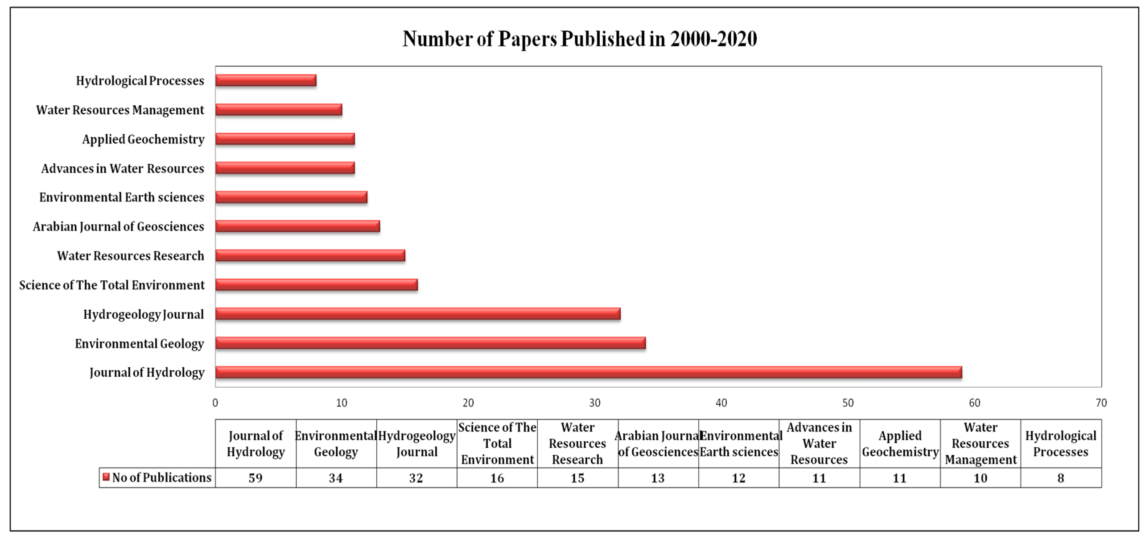
1.6. Review of Seawater Intrusion Research Papers between 2000–2020

An earlier review evaluated investigations in different regions using various methods for identifying seawater intrusion and the processes associated with SWI, as well as their role in coastal zone management. The review by [50] summarized the current status of information in seawater intrusion studies, compared groups with procedures for evaluating and controlling seawater intrusion, and identified areas of potential study. This review paper examines seawater intrusion study using three primary approaches: calculation, prediction, and management. Ref. [51] proposed the use of non-intrusive polynomial chaos expansions (PCEs) in SWI computational simulation studies to greatly speed up research. According to [52], the water shortage in China is caused by three factors: unequal spatial distribution of water resources, rapid industrial development and urbanization alongside a massive and growing population, and ineffective water supply management. In Australia, Ref. [53] examined how combining analytic and qualitative methods would provide a more systematic and less subjective seawater intrusion interpretation. Ref. [54] used three distinct methods to conduct research in a laboratory scale reservoir of porous medium to investigate a saltwater wedge’s distribution habits in a freshwater aquifer: (i) stable-state salt-wedge information collected under various hydraulic gradient conditions; (ii) transient salt-wedge data collected under intruding-wedge conditions; and (iii) transient salt wedge data collected under receding-wedge conditions. These recent experimental data sets enable the evaluation of how saltwater models operate both constantly and intermittently.
Ref. [55] reviewed seawater intrusion in European coastal aquifers in various geological and hydrogeological environments and in various coastal landforms. Analytical models of saltwater infiltration in coastal aquifers were used in an optimization technique for calculating the optimum pumping rates by [56] The goal of optimization is to make the most of total aquifer pumping while ensuring that the wells are protected from saltwater intrusion. Ref. [57] investigated the impact of pumping operations on seawater intrusion in Egypt’s Nile Delta aquifer. They suggested that additional pumping should be concentrated in the center of the Delta while avoiding the eastern and western sides, as these areas contribute to seawater intrusion. Ref. [58] looked at the best way to correct seawater intrusion and manage groundwater for long-term sustainability.
Ref. [59] used numerical simulations to investigate the transience of dispersive sea level rise and the intrusion of seawater in unconfined coastal aquifer settings. To compare with a previous seawater event of an instantaneous sea level decline seawater intrusion, an instantaneous sea level rise is used. The responses exhibit a temporal asymmetry in seawater intrusion from rising and falling sea levels. According to a simulation of seawater intrusion, the ‘representative reaction periods’ (time taken to reach 95 percent of the current steady state) for a one meter sea level increase varies from decades to centuries. The time it takes for different SWI quantitative metrics to react in a representative manner (e.g., toe position, wedge center of mass) shows significant differences. Seawater intrusion conditions are influenced by the tracking method used, which has consequences for research claiming a steady state has been reached. Ref. [60] analyzed the mixing rectification factor in Ghyben Herzberg and significant pumping rate quantitative measurements of intrusion of seawater in coastal marine aquifers.
Ref. [61] utilized stable isotopes (18O, 2H, and 13C) along with radioactive isotopes (3H and 14C) in conjunction with geochemical information to determine the source of salinization in various environments in Portugal. The results obtained served as valuable indicators for distinguishing between saltwater and freshwater, enabling the detection of seawater intrusion, as well as the identification of potential residual progressions. A possible surrogate model for the computationally intensive variable-density model is explored using the Gaussian process regression technique, according to a study by [62]. Gaussian process regression (GPR) is a nonparametric probabilistic kernel-based model that can manage complex input-output relationships. The position of the 0.5 kg/m3 iso color at the bottom of the aquifer represents the level of seawater intrusion in this sample. In Australia’s North Queensland, Ref. [63] illustrated the utilization of the SUTRA model (a variable-density flow and solute transport model) to determine the actual degree of intrusion of seawater in the Burdekin Delta beneath different pumping and recharge circumstances, as well as the effects of different managing alternatives on the quality of groundwater.
Ref. [64] experimented with laboratory and computational models to assess the cause of recharge well position and function, as well as the locality and infiltration distance downward of flow blockade, on regulating intrusion of seawater in unconfined coastal aquifers. Their findings revealed that water at the saltwater wedge results in further efficient saline water repulsion. In support of a similar renewed velocity, point injection produces a similar repulsion as line insertion from a monitored well. The findings for flow barriers showed that deeper blockade intrusion and blockades positioned nearer to the shore resulted in more efficient saltwater repulsion. The study by [65] attempts to summarize the history and current state of electrokinetic remediation research to discuss whether it can be used as a pretreatment tool to monitor seawater intrusion.
Ref. [66] proposed that the simultaneous usage of Cl and 18O capitulate four distinct groundwater endmembers, and three distinct combining possibilities are defined as describing the hydrogeochemical composition of intermediate salinity groundwater samples in different regions. In a vertical cross-section, a mathematical model was created by combining the effects obtained from the provided evidence. Using PHREEQC-2, three inverse modeling simulations indicate to facilitate every part of the theoretical mixing situation occurring since conventional materials are thermodynamically reasonable, including integration and ion exchange, as well as dolomite, gypsum, and calcite precipitation when allowing for hydrochemical changes.
According to [67] groundwater runoff is the major source of seawater infiltration in Greece, and heavy fertilizer use on farm fields is the cause of nitrate contamination in groundwater. According to [68] reviews, with several factors, the simulation-optimization modeling approach is very necessary to attain an ideal solution to seawater intrusion control problems. Ref. [69] used SEAWAT to model the seawater infiltration process of the Goksu Deltaic Plain along Turkey’s Mediterranean coast (1) to assess the aquifer’s hydraulic and hydrogeologic parameters, (2) to quantify the spatial variance of the aquifer’s salt concentration, and (3) to analyze the effect of increased and decreased groundwater extractions. Ref. [70] provides reviews on the implementation of several programming approaches to the issue of seawater intrusion control issues in coastal aquifers, with linear and nonlinear programming with multi-objective optimization models. Seawater intrusion vulnerability mapping in coastal aquifers is conducted in the Caspian Sea, Northern Iran, using overlay/index methods with a modified GALDIT model in terms of additional hydraulic gradient parameters GALDIT, GAiDIT, and GALDIT-i with applied vulnerability mapping suggested by [71].
Ref. [72] looked at seawater intrusion from an economic perspective, the various forms of “policy instruments” used in multiple empirical situations, and the potential evolution of groundwater policy aimed at preventing and managing intrusion of seawater into coastal aquifers. Ref. [73] employed GALDIT, the GQISWI (groundwater quality index for seawater intrusion), the Ghyben–Herzberg model, geostatistics, and geographic information systems (GIS) to establish a model that determines the pattern of groundwater pollution in the Sfax basin, Tunisia’s coastal aquifer by seawater intrusion. The relation among EC (Electrical Conductivity) and TDS (Total Dissolved Solids) in different forms of water was investigated by [74] to see whether there was any evidence of seawater intrusion.
Ref. [75] discussed seawater intrusion and its management in Australia and scientific challenges and future perspectives. Ref. [76] reviewed the inverse issue of seawater intrusion (SWI), which posed a challenge due to both conceptual and computational difficulties and the fact that coastal aquifer models exhibit many unique characteristics when numerical or inverse modeling is used. Ref. [77] investigated the coastal aquifers in Africa, including their current state, future prospects, and aquifer management. Among the several papers we looked at, ref. [78] examined the present condition of seawater intrusion and the sites of SGD in India with groundwater levels calculated in 991 wells and addressed various methodologies for detecting and mitigating seawater intrusion. Ref. [34] studied the coastal aquifers of China, their coastal groundwater supplies, how they were affected by seawater intrusion and subsurface barriers, and how they used groundwater reservoirs and induced artificial infiltration to protect natural groundwater resources in coastal aquifers. Ref. [79] examined the research activities carried out to maximize the use of Apulian coastal groundwater, which has a seashore of over 800 km and is home to the world’s largest coastal karst aquifers. Groundwater resource exploitation is important, especially in coastal regions of arid and semi-arid regions. These regions’ coastal aquifers are especially vulnerable to salty seawater intrusion according to [80], with as an example Tripoli on the Mediterranean shore of the Jifarah Plain in northwestern Libya. Ref. [81] examined human effects on land degradation by examining the combined impact for diverse cultivation methods and agroclimatic zones in Lebanon where fertilization and irrigation has caused salinization.

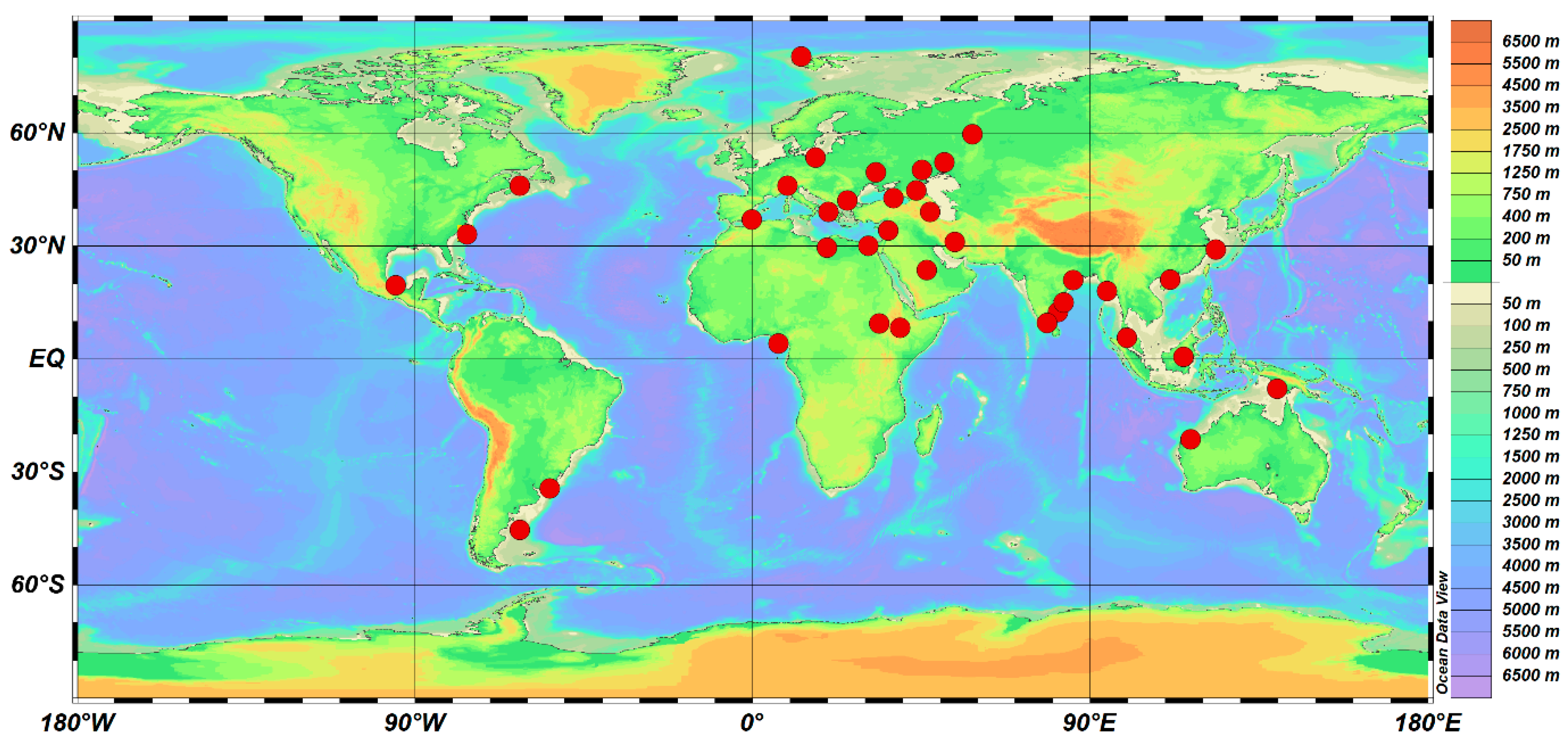
1.7. Data Collection

This paper reviews, in detail, a range of key studies about SWI by considering papers published between 2000 and 2020. All these papers were collected using Harzing’s Publish or Perish [82] and VOS viewer [83]. The VOS viewer identified author contributions related to SWI. A total of 997 papers were collected and nearly 30.59% of them were in Q1 (19.15%) and Q2 (11.43%) journals. We selected 94 research papers, including 32 reviews for the present evaluation. They were selected based on the scope of this review such as the identification of the SWI zones in different areas, location/country, and different marine environments like estuaries, lagoons, and bays. First of all, the articles from 11 journals were derived from the database using the keyword “Seawater Intrusion” (Figure 1). Secondly, we considered the number of papers published in these journals (Figure 1). Thirdly, the share of papers (%) of each journal out of the total publication during 2000–2020 was estimated (Figure 1). We reviewed different methods used in SWI identification like various geophysical methods, geochemical and isotopic methods, and statistical analysis. Numerical and hydrogeological modeling was used to investigate the probable SWI zone identification (Figure 1). Based on the issues of investigation, we subcategorized this review to focus on (i) systematic evaluation of global SWI areas assessed by different methodologies and author contributions, (ii) SWI identified areas across the world using publication results, and (iii) bibliometric analysis of SWI publications for evaluation of the current status in coastal zone management, including the research gaps.
A total of 997 papers received 36,762 citations during 2000–2020 and these data was separated into cites/year (1750.57), cites/paper (36.87), authors/paper (3.22), h-index (90), g-index (136), hI norm (50), and hI annual (2.38).

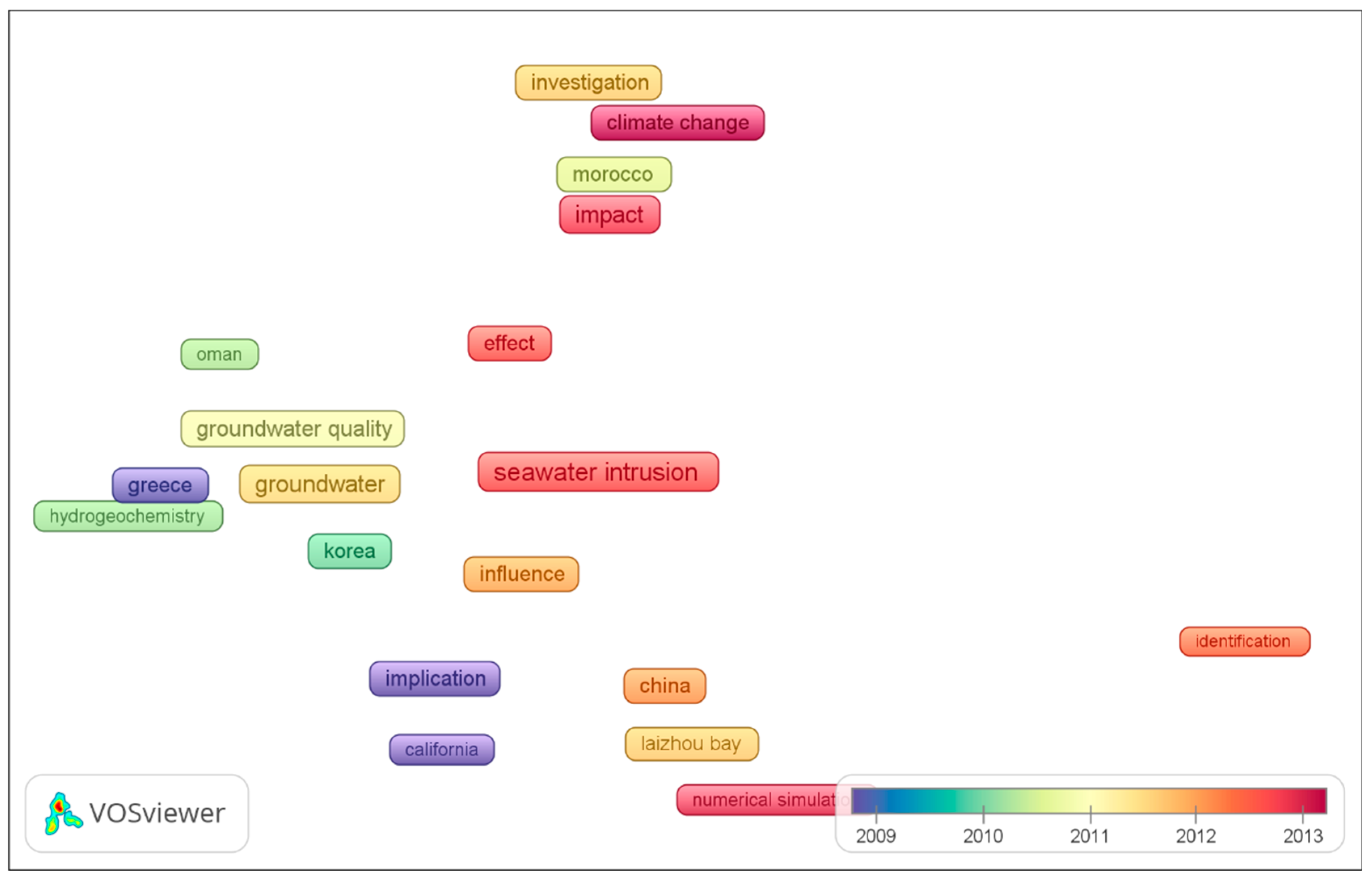
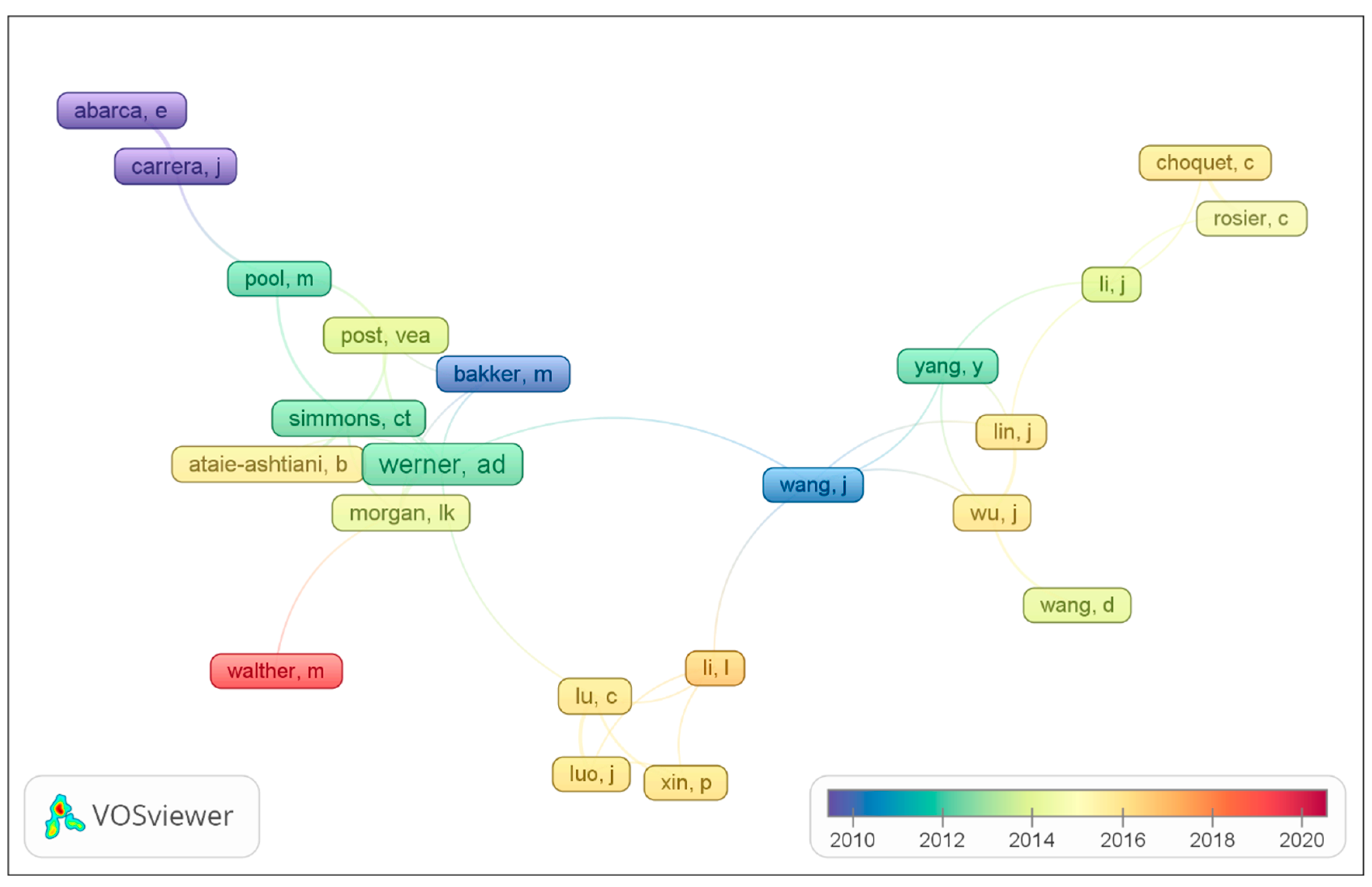
1.8. Keyword Analysis

The VOS viewer software 1.16.15 provided insight into the main topics and their research trends using the title keywords extracted from the source file. Out of the 2503 terms, only 44 met the threshold and a relevance score was calculated for each of them in order to select the mainly appropriate terms. The default option was to decide on the 60% mainly appropriate terms. The network of 25 terms was divided into 6 different clusters (Figure 2): 1 (six items; coastal area, Greece, groundwater, groundwater quality, hydrochemistry, and Korea), 2 (seven items; climate change, impact, investigation, Morocco, numerical modeling, saltwater intrusion, and sea level rise), 3 (six items; California, effect, implication, influence, seawater, and seawater intrusion), 4 (three items; China, Laizhou Bay, and numerical simulation), 5 (one item; identification), 6 (one item; Oman).
These papers were published in 25 different journals (Figure 3) and a significant number of them were identified in eleven major journals contributing 22.12% (221 articles) of all the papers published (Figure 4). They are represented by the Journal of Hydrology (5.91%), Environmental Geology (3.41%), Hydrogeology Journal (3.20%), Science of the Total Environment (1.60%), Water Resources Research (1.50%), Arabian Journal of Geosciences (1.30%), Environmental Earth Sciences (1.20%), Advances in Water Resources (1.10%), Applied Geochemistry (1.10%), Water Resources Management (1.0%), and Hydrological Processes (0.8%) (Figure 4). In brief, the topics examined were relevant to the seawater intrusion zones, their assessing methodologies, and their importance in coastal zone management. The identification of SWI by geophysical and geochemical techniques was carried out using various methodologies, statistical analysis, and numerical and hydrogeological modeling in different marine environments.

1.9. Diverse Methodologies Used in the Investigation of Seawater Intrusion (SWI) in a Global Perspective

Over the years, several experiments on coastal aquifers have been conducted to determine how seawater intrusion occurs (Table 1). Electrical conductivity (EC), salinity, water temperature, total dissolved salts (TDS), and seawater mix are several of the physicochemical characteristics of the subsurface that are determined during the investigation of seawater intrusion [84]. The approaches used to accomplish this would be classified into two categories: (i) direct and (ii) indirect.
Direct methods involve the collection and analysis of water samples for a variety of physicochemical factors, whereas indirect methods rely on measurements of volumetric conductivity, volumetric resistivity, and seismic velocities of the aquifer to interpret hydrological properties. Geochemical analysis of groundwater samples and water table measurement are two examples of traditional direct techniques used in studies of seawater intrusion. Geographic information systems (GISs) and remote sensing methods are used in many situations in direct and indirect techniques for monitoring coastal aquifers. An explanation of the most general direct and indirect methods for investigating seawater intrusion is shown in Figure 5.

1.10. Direct Geochemical Methods

The primary source of coastal groundwater’s higher salinity is seawater intrusion. Entrapped fossil seawater, sea-spray accumulation, and evaporite rock dissolution can contribute to high salinity. Anthropogenic contributions from waste effluents, industrial effluents, mine water, and road deicing salts could all contribute to the salinity of coastal water [127]. Changes in coastal groundwater salinity are commonly linked to (i) freshwater–seawater mixing, (ii) carbonate deposition, (iii) ion exchange, and iv) redox reactions [84]. Major ions (Na, Cl, Ca, Mg) as well as minor ions (Br, F, I) are generally used to determine the leading processes that control the saline nature of groundwater at a given place [78]. Further parameters like EC and TDS are used to accurately find the most important infiltration plumes in coastal regions [128,129,130]. Ionic concentrations as tracers intended for seawater intrusion, including Na+-Cl, Cl-Br, Ca-Mg, Cl-HCO3, Ca-(HCO3 + SO4), TDS, and conductivity are water quality parameters that characterize saline levels in water. The procedure of extracting TDS analysis of a water sample is time-consuming, but is much better at illustrating groundwater quality than any other form of analysis. The estimation of TDS concentration is easy if the EC value is known. However, the ratio cannot be described straightforwardly. In addition to salinity, the content of materials also influences solubility. Ref. [87] used geophysical, geochemical, and stable isotope methods to assess the seawater intrusion in coastal aquifers and showed that seawater intrusion happened due to excessive pumping plus anthropogenic and agricultural activities. According to [88], the Souss–Massa basin in the west-southern portion of Morocco has a large difference in salinity between groundwater and surface water. According to [30], the Gaza Strip’s water supply is highly polluted and immediate measures are required to improve its quality and increase the groundwater recharge. In certain areas, the natural equilibrium between fresh and saltwater has been interrupted, resulting in increased salinity. Salinization of the coastal aquifer may be caused by a single mechanism or a combination of processes, including seawater intrusion. The salinization of groundwater in reaction to sea level increase is studied using analytical techniques and computational tests. A saturated porous medium with an angled upper surface is the suggested cause of the problem.
Ref. [91] used physico-chemical analysis to assess salinization on the Lebanese coast caused by seawater intrusion in the Chouat-Lebnne region that threatens agricultural productivity. Many studies have used stable isotopes of oxygen (δ18O), hydrogen (δ2H), and boron (δ11B) to trace the source of water as well as the role of seawater mixing in the quality of groundwater in coastline areas [130]. Ref. [108] attempted the quantification of geochemical processes and the time of penetration of seawater in a coastal aquifer using changes in the main ionic composition of the water and the natural distribution of cosmogenic isotopes 14C and 3H from the Israeli coastal aquifer. According to chemical records from coastal aquifers in the region, concentrated ion exchange of lightly dissolved salty groundwater is a significant occurrence of seawater intrusion. The majority of our freshwater groundwater samples have large 3H concentrations, suggesting that seawater from the Mediterranean Ocean intruded and moved inland to a gap of 50–100 m onto land 15–30 years ago.
The strontium isotopic ratio (87Sr/86Sr) was used by [50] to distinguish between past and recent seawater intrusion. In South India’s coastal zones, seawater intrusion has been observed using EC, Na, and Cl concentrations [117]. Geochemical parameters were used by [131] to calculate the quality index of groundwater for seawater intrusion in Eastern Mediterranean areas. Ref. [96] studied the key factors and processes governing the unconfined aquifer of Bou-Areg on the Mediterranean coastline of Northeastern Morocco that was examined for groundwater chemistry and salinity using hydrogeological and geochemical evidence as well as the findings of an ERT survey (electrical imaging tomography). The salinity distribution was also calculated using statistical and geochemical interpretation techniques. [103] used geoelectrical imaging to monitor the intrusion border between fresh water and saline water in Yan, State of Kedah, Northwest Malaysia.
Ref. [93] studied seawater intrusion in Korea’s coastal zones, focusing largely on groundwater to determine the invasion of saline water, which is closely related to groundwater depletion. The Na–Cl and Ca–Cl forms account for a significant portion of the groundwater. The results of seawater intrusion are described by the Na–Cl groups. Significant parts of the groundwater showed salinity potential and could be best maintained for long-term irrigation.
Ref. [114] investigated the Mersin–Kazanl area which is highly industrialized where saltwater contamination has arisen as a consequence of the rising water demand. Since the wells were dug, the chloride content of water samples from some of them has been determined regularly. The outcomes of these studies, as well as EC (electrical conductivity) tests, were used to represent the history and evolution of saltwater intrusion up to the year 2000. In 1999, the Cl2 content in the water surrounded by the alluvial aquifer reached over 3000 mg/L and the wells were shut down. Fresh wells have been drilled more than 1 km from the sea and the old well site in 2001. The actual groundwater condition was assessed using the analysis of the 2001 studies. The composition of groundwater is magnesium–calcium–bicarbonate, which is restricted by the contact of the water with alluvial deposit sediments.
Ref. [95] set out to describe the physico-chemical properties of groundwater in the Tarsus coastal plain (TCP) of Mersin, Southeastern Turkey, wherever human activities (farming, commercial, and household) are very strong. Hydrochemical data show that during the Quaternary, a subsurface paleo river stream and dump invaded the ancient lagoon area. The recent alluvial deposits are valuable hydrological features since they allow for preferential groundwater flow over their entire length. Ref. [94] investigated a coastal freshwater wetland in the Rhône Delta, France, similar to those found in the Mediterranean Sea. Researchers may determine the cause of groundwater salinity and the geochemical processes that occur in this coastal confined aquifer based on electrical conductivity values that rise to the north (4 mS/cm) of the seashore (58 mS/cm) in this delta’s confined aquifer. Ref. [85] used a hydrogeochemical and isotopic analysis on Jeju volcanic island, Korea, to detect salinization accompanied by cation-exchange reactions. The area has a low hydraulic gradient and discharge rate, as well as a strong hydraulic conductivity.

1.11. Statistical Analysis and Modeling of Seawater Intrusion

Subsidence induced by groundwater depletion, subsidence stimulated by construction load (i.e., settlement of high compressibility land), subsidence created by environmental accumulation of alluvial soil, and tectonic subsidence are all expected to occur in the Jakarta basin in Indonesia, according to [109]. Survey approaches based on a GPS survey were used to investigate land subsidence in Jakarta. These basin-wide GPS measurements demonstrated how these types of data can be used to inform a variety of public policy decisions in this rapidly expanding field.
Research conducted by [90] has shown the usefulness of R-mode and Q-mode hierarchical cluster analysis to determine groundwater salinity units in southeastern Ghana. Both methods were used for spatial classification of groundwater samples and the source of groundwater salinity was then derived using R-mode factor analysis. Those three main indices were used to measure the quality of groundwater for irrigation. Two main causes of groundwater salinity were found to be anthropogenic and diagenetic weathering of silicates and seawater intrusion. Ref. [110] have used optimization approaches. There is a groundwater managing difficulty in an offshore karst aquifer in Crete, Greece, despite environmental constraints. A computational replication form of the unconfined coastal aquifer was developed to symbolize the dynamic non-linear substantial framework. The algorithm used is a Differential Evolution (DE) algorithm to mimic a number of the concepts of progression. The results obtained using the two related optimization methods are compared. In conclusion, the effect of successful pumping wells on the construction of the seawater intrusion façade along the entire coastline is determined by a sensitivity survey.
Ref. [20] used multivariate statistical study of physico-chemical compositions to identify the major factors influencing groundwater consistency in Kimje, South Korea. Groundwater content is governed by a variety of factors, including chemical fertilizers, microbial activity, and seawater intrusion. In the Keta strip of the Keta basin, ref. [90] primarily recognized mineral weathering and seawater intrusions through multivariate statistical and spatial analyses to promote groundwater salinity in the basin. The sodium adsorption ratio (SAR) is low because of the seawater penetration. The effects differ depending on the depth of the water table and sea level. The sodium amount is increased by the intrusion of saltwater in some of the wells tested, as determined by the SAR norm.
Ref. [132] in Noord-Holland, Netherlands, investigated the salinity of a shallow aquifer which was projected to rise dramatically using numerical modeling, resulting in a substantial increase in salinity in the shallow aquifer, creating an enormous increase in salt content in all low-lying areas of this part of Netherlands.
Ref. [116] used a three-dimensional model of the aquifer system on Virginia’s Eastern Shore to calculate historical salinity levels and forecast future levels. A prediction of future salinization areas is performed through two pumping schemes. Simulations predict that by the end of the century only a few wells will be affected by detectable salinity changes. Ref. [98] investigated the saltwater and freshwater flow along India’s Godavari Delta, using a SUTRA (Saturated-Unsaturated TRAnsport) model to simulate the density-driven salt-water infiltration method. The delta’s physical parameters, initial heads, and boundary conditions were described using field data. The findings suggest that if existing rates of groundwater utilization persist and a significant portion of the freshwater of the river is channeled from the reservoir for agricultural, commercial, and household uses, a significant increase in seawater penetration in the coastal aquifer can be anticipated.
Ref. [133] in Dongguan, China, developed a concept of hydrochemical evolution by evaluating hydro data and land use versus spatial to hydro pollution by analyzing the origins of trace elements using principal components analysis (PCA) and hierarchical cluster analysis (HCA) and how they were dispersed in groundwater by seawater penetration, the lateral flow of the river, commercial, waste, and agricultural pollution impacts.
Ref. [101] investigated the Mar del Plata aquifer, which is made up mostly of silt and fine sand that contains some potassium feldspar and gypsum. Hydrogeochemical modeling was used to investigate primarily cation exchange processes. The regional water extraction choice from the aquifer saturation causes Ca > Na, but the salinization mechanism has the opposite effect. The PHREEQM code is useful for evaluating the equilibration in a seawater intrusion.
Ref. [117] have attempted to measure the water quality in the region of the Chennai Coast of India. For selected sites, the physical and chemical parameters of the groundwater were measured. The water samples indicated a pH range of 7.2 to 8.2. Positively associated levels of both Na and Cl concentrations were identified near the coastline, particularly in the northern region. A Piper diagram highlighted the presence of NaCl in many of the samples. When Ca–Cl facies are found in the groundwater, ion exchange is most likely occurring in the aquifer. Molar ratios of Cl/HCO3 and Ca/Mg were observed in several samples, indicative of seawater intrusion. Hardness measurements indicated that 64% of the samples were hard/dense. The SAR, Na% findings, and Na% results indicated that the bulk of the samples are suitable for agricultural activities. Water quality comparison shows strong depletion in the groundwater in Thiruvanmiyur, Chennai. According to the findings, urbanization and seawater intrusion have impacted groundwater quality in South Chennai’s coastal districts.
To determine the mechanism of groundwater salinization in coastal aquifers, ref. [47] used modified hydrogeochemical and isotopic analysis as well as inverse hydrochemical modeling in Laizhou Bay in China, which is contaminated by seawater intrusion. To facilitate comprehension of water-related phenomena from the vertical perspective, a mathematical model was created using data acquired from the study of cross-sections. Using the results of three inverse-geometric equations from PHREEQC-2, all conservative mixing conditions are possible.
Ref. [102] investigated the role of the Yellow River due to soil salinization. They used remote sensing and field observations, as well as model-based spatial simulations, to investigate the distribution of saline soils over the previous two decades. They used a random multivariate regression of the observations to boost the accuracy of the estimated salt content of soil. The Yellow River is facing significant ecological concerns as a result of decreased water supply discharge and increased seawater contamination.
Ref. [58] described the utilization of groundwater storage approaches in coastal aquifers. Corrective actions must be carefully planned to increase water quality while avoiding increasing the current pumping schedule. Linear formulation provides insight into the best pumping allocation. The linear formulation, in particular, enables easy quantification of the hydraulic performance of corrective actions (increase in pumping rate per unit increase in recharge rate). The fact that productivity is reliably higher demonstrates that the hydraulic fence not only expands but also preserves existing infrastructure. As a result, all optimization methods are effective and can be used. Salinization of land resources, according to [106], is a significant impediment to their optimum use in many arid and semi-arid regions, including Iran. Different methods have been used to increase the production of salt-affected soils in the region, with differing degrees of success—salt leaching and drainage interventions, crop-based maintenance, chemical additives and fertilizers, and combined implementation of these approaches. Previous research has revealed that advanced salinity control and mitigation techniques can effectively solve the dynamic problems of salt-induced land depletion in Iran from a sustainable management perspective.
In the Pioneer Valley’s coastal aquifers, seawater intrusion is contaminating freshwater sources, according to [7]. To investigate local-scale development and help in the consideration of executive techniques for the framework, the MODHMS code was used to construct a three-dimensional sea-water intrusion model. By providing an alternative assessment of susceptibility, a sea-water intrusion potential map created through hydrochemistry, hydrology, and hydrogeology analyses compensates for model shortcomings. The Pioneer Valley’s sea-water intrusion is unbalanced, and additional landward changes in the level of salty groundwater are possible. Tidal over-height (the additional tidal hydraulic head at the coast) must be taken into consideration for over-height values within 0.5–0.9 m, thereby giving enhanced water table estimates. The model’s vulnerability to shifts in the coastal hydraulic boundary was dominated by the initial water table condition. Several salination processes, instead of simply advancing landward seawater from “new” sea springs, are likely to be taking place in the Pioneer Valley. The vertical discretization method has been exposed to initiate several faults in water table forecast.
The Burdekin Delta, North Queensland, Australia had actual and possible levels of seawater intrusion which were determined using SUTRA, a variable-density flow and solute transport model investigated by [63] The findings of this investigation show the effect of the dynamics of marine water intrusion on differing pumping and net charging rates. A variety of regeneration, pumping rate, and hydraulic conductivity values have been simulated. Modeling findings suggest that pumping speeds and recharge are much more vulnerable to seawater penetration than aquifer properties like hydraulic conductivity.
Overdraft and seawater intrusion is a serious threat in the Balasore coastal groundwater basin in Orissa, India, according to [112]. Numerous shallow tube wells in the basin were abandoned due to overexploitation. The primary aim of this analysis is to use the Visual MODFLOW package to construct a 2D groundwater flow and transport model of the basin to examine the aquifer reaction to different pumping strategies. The sensitivity analysis revealed that river seepage, rainfall recharge, and interflow are more vulnerable to the aquifer where horizontal and vertical hydraulic conductivities were measured. In conclusion, key management strategies for the long-term sustainability of the Balasore groundwater basin’s vital groundwater resources are formulated based on the modeling results.
Ref. [104] proposed that unchecked exploitation of the groundwater triggers a modification of the natural water flow mechanism, an infiltration of the semi-arid Mediterranean ecosystem from the coasts, and a depletion of the content of the soil in the Korba aquifer which is located in Northeastern Tunisia. Mineral saturation simulation of the aquifer seawater-freshwater mixture study was performed using the PHREEQC 2.8 program, and saturation indices were calculated using higher chloride levels, inverse cationic reactions, and a lower piezometric level relative to sea level.
Ref. [105] examined the utility of 2D electrical imaging for the characterization of seawater intrusion utilizing field data from a location in Almeria, Southeastern Spain. If image appraisal instruments are used properly to measure the background, the electrical imaging of seawater intrusion models may be used. Due to the lack of resolution with depth, numerical calculations employing a hydrogeological model revealed that it is only possible to restore lower salt concentrations in the transition zone between seawater and freshwater.

1.12. Indirect Geophysical Methods

Seawater infiltration (SWI) results in privileged Na+ and Cl- concentrations in coastal aquifers, as shown by higher EC values. The water quality of the coastal aquifer can be determined using EC values from the aquifer or the resistivity of aquifer fluids. High resistivity values with lower EC and lower resistivity values with higher EC suggest saline groundwater in coastal areas [78]. Electrical methods (resistivity and electromagnetics) are widely applied in coastal regions to separate subsurface brackish or seawater bodies from freshwater. Vertical electrical sounding (VES) and electrical resistivity tomography (ERT) are the most widely employed electrical resistivity techniques for studying seawater intrusion in coastal areas [134]. A magnetic field on the surface induces an electrical current in the sub-surface and is determined by electromagnetic methods to quantify the secondary magnetic field generated by the induced flow.
Ref. [97] used a unique time-lapse electrical resistivity tomography (TL-ERT) experiment to chart the effects of intrusion of seawater in the southern Venice Lagoon’s coastland. With a formation resistivity of 1.0 ohm/m, which corresponds to a salinity of 25–30 gr/L, the shallow aquifer is the most affected by salt intrusion. In the autumn-winter season, the saltwater front intrudes landward, and travels back seaward in the spring-summer season, causing seasonal resistivity fluctuations. TL-ERT seems to be an effective strategy for performing multi-scale pollutant testing at various time scales, based on this experience.
The freshwater-seawater interface in the coastal aquifer is found using a comparatively low frequency (VLF) electromagnetic unit [84]. In addition, seismic techniques are utilized to determine lithological margins, which might expose hydrological in order regarding geological arrangement. This device, which is dependent on the mechanical properties of geological structures, is used to quantify and interpret changes in seismic velocity. The method has proven incredibly useful in interpreting the subsurface into remote regions. Ground-penetrating radar (GPR) may also be used to identify the freshwater–seawater interface in a coastal aquifer [134]. However, these methods are only applicable to subsurface depths of a few meters to a few hundred meters. Borehole logging techniques may be used to investigate the deeper subsurface. The use of a variety of geophysical approaches will provide accurate knowledge regarding the hydrological condition of the subsurface. The freshwater–seawater mixing area was precisely located by [135] using a high-resistivity electrical tomography technique in Chennai, Tamil Nadu, India. Ref. [136] investigated the intrusion of seawater into Israel’s coastal aquifers using a time-domain electrical resistivity process. Seawater intrusion in coastal alluvial terrain with thick clay deposits may also be assessed using VES and shallow seismic refraction methods [137].
Ref. [115] of Ham Basin, UAE indicate that their water source aquifer has been substantially overexploited to satisfy rising demand in the last two decades. The dynamic equilibrium of freshwater and seawater has been broken, thus affecting the consistency of groundwater. Wadi Ham is a region in Oman where a 2D resistivity survey was undertaken to define seawater intrusion. Existing measuring wells were used to collect horizontal and vertical measurements to assist with the understanding of ground resistivity. These relationships were used in tandem with 2D resistivity inversion data to reveal three separate water zones (fresh, brackish, and saltwater). Near the 2D resistivity interface, the depth was greater than 50 m in the west and 2 m or less in the east. The brackish water level was about 70 m in the west and about 20 m in the east. When new water enters the agricultural fields, seawater intrusion rises.
Ref. [113] used the automated time-lapse electrical resistivity tomography (ALERT) method for long-term scrutinizing of coastal aquifers. The ALERT device is permanently mounted on the Andarax River in Almera, Spain, to observe and control the effects of climate transformation and land management in the quaternary aquifer below. A series of electrodes about a mile long were buried in the normally dry riverbed, and electrode samples were taken every 10 m. The investigation can go as deep as 160 m below ground level. The ability to obtain volumetric geoelectric images of the basement on demand makes costly repetitive examinations unnecessary. The entire process is automated and transparent from data acquisition to imaging. Overuse, sea level rise, anthropogenic pollutants, and seawater penetration are all elements of the water system that ALERT technology can recognize. Hydrogeological characteristics, including the seawater-freshwater interface, are interpreted (spatially and temporally) from the electrical images obtained. Groundwater changes can be detected and imaged in real-time, which can assist in the control of pumping and irrigation schemes.

1.13. Applications of Remote Sensing Images and GIS

Remote sensing imagery can also be used to identify surface waters such as streams, reservoirs, wetlands, infiltration areas, recharge areas, and other features useful for predicting groundwater flow. Using satellites to observe features on the surface gives insight into subsurface features. These methods are useful for quickly mapping groundwater, particularly in broad and difficult-to-access regions. Spectral signatures of groundwater-related surface features, such as vegetation and runoff, are easy to see on satellite images [138].
Measuring fluorescence and color absorbance with the Wet Labs fluorescence and color-absorption apparatus, ref. [111] measured in situ the multispectral fluorescence of negatively stained organic matter (COM) and chlorophyll-a (Chl-a) in surface waters of the West Florida Plateau (Safire). Simultaneous mapping of the propagation pattern of organic flux and Chl-a on the plateau was made by continuous measurements. To distinguish between riverine and marine COM, they used two fluorescence emission ratios. COM concentrations were found to be unusually high offshore. An expanse of the Mississippi River plume is probably the cause. Similarities of calculated Chl concentrations in situ with the SeaView and SeaView Large Field-View Sensor (SeaView-Sensor) indicated that both algorithms had incorrectly estimated the Chl concentrations in high concentrations of MODIS readings revealing that the MODIS-based method had outperformed the OC4 algorithm in areas with high MODIS concentrations. Concentrations of Chl-a and COM demonstrated variation observed in the sample area, perhaps because of variations in the supply from the river.
Ref. [139] observed seawater intrusion into the Pearl River estuary in China using satellite images from EO-1 and ALI. Ref. [140] delineate coastal areas affected by seawater in central Greece using Thematic Mapper (TM) and high-resolution Landsat satellite photos. Expected seawater salinity intrusion in the Mekong Delta, Vietnam, is derived from Landsat data by [49]. Then, Landsat photos were used to measure the salinity of the soil in the area [141]. In evaluating the geographic variation of water quality parameters, the Geographic Information System (GIS) has proven to be highly useful [15]. Remote sensing along with the Geographic Information System (GIS) method is often used in combination with additional studies such as Vertical Electrical Sounding (VES) and hydrogeochemical studies to recognize different paths of seawater intrusion [142]. Using the Geographic Information System (GIS) technique, regions with high salinity have been identified in the Maharashtra state of India [143].

1.14. Mitigation Methods

Because of the significant spatiotemporal differences, investigating, tracking, and managing seawater intrusion is a difficult activity. Due to regional and local differences in hydrogeological situations and human actions, the quality of groundwater in two wells separated by tens of meters could be dramatically dissimilar. Those differences make it difficult to control groundwater supplies cost-effectively and sustainably in coastal regions. There are several methods for managing coastal groundwater. However, there is no set formula for determining which technique can be used to protect coastal groundwater in a specific area. A poor management strategy could lead to the depletion of freshwater availability. The current state of quality of groundwater and intrusion of seawater, hydrogeological classification of the area, recovery and assessment of use, and other factors must all be considered when determining the best groundwater management techniques. The following are some of the most relevant management techniques.

1.15. Reduction in Pumping Rate

Reducing overdraft rates and groundwater withdrawal rates are two of the most cost-effective and least expensive measures to prevent more seawater from entering the marine aquifer [78]. The declination of overdraft could be accomplished by using water on the surface and precipitation for agricultural purposes through artificial drainage channels [144]. Ref. [145] found that regularly changing harvesting patterns and avoiding water-intensive crops such as rice, soybeans, and others can significantly reduce groundwater pumping. In coastal areas, the development of the most important commercial construction that involves large amounts of water should be restricted. Desalination units will furthermore minimize groundwater requirements by allowing salty groundwater to be used in industrial processes [21,146].
When properly treated, domestic used water and water employed in manufacturing processes could also be recycled for other purposes. Facilitating the supply of water to coastal areas from the distant interior will require pumping operations. The main reason for the implementation of this approach is high population growth, which results in high water demand. In certain situations, an alternative accessible water source is small, and obtaining water of high quality is relatively expensive; as a result, the approach fails to attain its target.

1.16. Rehabilitation of Pumping Wells

The rapid inland flow of seawater would be caused by intense pumping operations along the seashore. The freshwater–seawater boundary is usually found at a low depth near the shore, but it can also be found at greater depths inland. As a result, moving coastal area wells to local areas may reduce seawater intrusion [78]. Reducing pumping activity in the seawater affected region will help restore the normal hydraulic gradient between the seawater and freshwater and prevent seawater from moving inland from the ocean [145]. This approach works well in coastal aquifers with much lateral heterogeneity. However, the expense of relocating wells may not be useful in certain situations. When determining where to relocate the shifted wells, a carefully considered strategy is needed.

1.17. Rainwater Harvesting by Recharging Aquifers

Replenishing a freshwater source by nature usually takes a long time. The intensity for which groundwater is withdrawn generally exceeds the rate of natural recharge. The groundwater head falls as a result of these conditions, causing seawater to migrate inland. Accelerating the usual recharge of water in the coastal regions could be an important method for dealing with the issue of seawater intrusion. The groundwater has been connected to the surface water in this stage throughout different artificial structures. According to [2], salt water entered through most coastal aquifers in the United States, Mexico, and Canada. Coastal areas in North America are taking steps to control and avoid seawater intrusion and make certain a safe supply of fresh water for the future prospect. Old ancestral structures including ponds/tanks potentially enhance groundwater recharge that has been over-exploited in vulnerable areas [14]. According to [147] building a series of dams could contribute to the recharge of groundwater in marine regions while reducing the method of seawater intrusion. The growth of dense forests alongside the coast increases the ability of the aquifer’s sediments to retain water and prevents seawater from flooding. Not only is the procedure environmentally friendly, but it is also cost-effective. It does not necessitate a large amount of land or population relocation. Nevertheless, the lack of fine water quality for recharging, particularly during periods of drought, is the main problem with this approach. However, there are risks of surface water recharge contaminating groundwater. Another constraint is the expense of developing subsurface structures. If stored and used properly, precipitation could be a sustainable water supply that is very useful in related water shortages. Rainwater storage may help to avoid the dangers of stormwater runoff. Accumulating precipitation can be utilized for recharging groundwater, for household and farming purposes, and for further uses. With the running down of the water table due to changing climate conditions, harvested rainwater may play an important role in meeting groundwater demands, particularly during dry seasons.
Rainwater harvesting not only alleviates built-up floods, but also assists the recharge of regional aquifers and water supply to arid regions ([148]. Recharging of groundwater raises the water table and reduces the likelihood of entry of salty seawater. According to [149] rainwater harvesting has many benefits, including reducing water scarcity, replenishing established sources, preventing seawater infiltration, automatic soil filtration, and conservation of water for farming purposes during dry times. While rainwater collection is based on precipitation, rapid alteration in precipitation is a main problem for this strategy.

1.18. Artificial Recharge and Construction of Wells

The construction of several injection freshwater wells near the ocean could assist in maintaining the freshwater-seawater balance. The freshwater–seawater interface is pushed back into the sea by the high-pressure freshwater injection [78]. This approach was used by [120] to recharge groundwater in California, USA. This approach is best suited to coastal areas with limited land availability and a well-connected river system. These rivers could serve as local sources of injected freshwater. Freshwater injections in large quantities can raise the water level, pushing the seawater front away from the shore [150]. Injecting low-quality freshwater, on the other hand, can cause groundwater quality to deteriorate. Furthermore, high-pressure injections can change pore pressure and aquifer properties. A different way to move the interface between freshwater and seawater in the sea is to build a system of seawater catchment wells close to the sea. Ref. [145] demonstrated that the extracted seawater can be used in desalination units or directly discharged into the ocean. Extreme seawater withdrawals can lead to the formation of an offshore hydraulic head that can direct water movement out to sea while protecting the coastal aquifer from seawater intrusion. To prevent freshwater extraction, it is important to carefully measure the seawater abstraction rate. In most cases, pumping the seawater out completely is neither cost-effective nor realistic.

1.19. Construction of Barriers

Physical subsurface barriers may be built to prevent seawater from flowing inland into coastal aquifers. To prevent infiltration from below, these blockades are generally built of concrete, grout walls, and other strong materials over impermeable layers. They have a longer lifespan and need less upkeep [145]. The construction of physical barriers not only prevents the entry of seawater, but also prevents seawater from mixing with fresh groundwater [151]. Underground barriers have been put in place on the Pacific Island of Okinawa to prevent seawater from entering the coastal limestone aquifer [152]. In shallow coastal aquifers, this approach may be profitable and produce excellent outcomes. Building a retaining wall (or other underground structure) in shallow aquifers can be prohibitively expensive. Without impermeable layers at a shallower level, seawater could diffuse below the depth of the barrier.
Infill wall channels that have a high permeability will be more useful to groundwater and solute flow, whereby such paleochannels may act as hydraulic pathways between coastal aquifers and the sea allowing inland or seawater infiltration since palaeochannels have been reported to form in numerous cases of brackish water intrusions, and there has been little direct evidence to support the claim. When submarine constraining units break apart, coastal plain water flow may occur. The discharge has a clear majority of its volume on the borders of the channel to its surroundings, causing more saltiness in the middle of the channel compared to its surrounding environment. This demonstrates that freshwater extraction on land can create these aquifer flow channels.

1.20. Groundwater Scrutinizing Network

Different water legislation and regulations have been executed at national and state levels around the world to ensure better distribution and protection of coastal water sources. High-resolution data on water quality is essential to assess the true state of seawater inflows and can only be obtained through a well-developed monitoring network. Daily water resource scrutinizing, moreover, aids in detecting diminishing rivers, lakes, and surface water resources owing to siltation and cut-off points of running water like watershed clearing in catchment regions [144]. Moreover, these organizations create awareness through numerous awareness and training programs to afford critical data for plan improvement. People are informed regarding the effect of their work attempt on the regional quality of groundwater and seawater intrusion through the periodic publication of reports.

1.21. Authors’ Contribution

The VOSviewer software was used for the analysis of the authors’ contribution to the SWI research area. It provides the imminent main research interest in seawater intrusion (SWI) according to the research trends in the past two decades. The full counting method is used to extract the authors’ information from the Research Information System (RIS) type format source file that will be downloaded from the Harzing Publish or Perish (Version 8) software Google Scholar search as is mentioned above. Out of the 2010 authors, 88 met the threshold. For each of the 88 authors, the total strength of the co-authorship links with other authors will be calculated. The authors with the greatest total link strength will be selected. From these connected networks, only 22 authors are well connected. Finally, the network contains 22 authors and 6 clusters. Cluster-1 (5 authors; lin, j; wang, d; wang, j; wu, j; yang, y) Cluster-2 (5 authors; bakker, m; morgan, lk; post, vea; walther, m; werner, ad) Cluster-3 (4 authors; li, l; lu, c; luo, j; xin, p) Cluster-4 (3 authors; abarca, e; carrera, j; pool, m) Cluster-5 (3 authors; choquet, c; li, j; rosier, c) Cluster-6 (2 authors; ataie-ashtiani, b; Simmons, ct) The results of the analysis of the authors’ link strength as viewed in the VOSviewer overlay visualization of the authors in the past two decades (2000–2020) are shown in Figure 6.

2. Conclusions and Suggestions

The overall research advancement in various investigations and locations of the global Sea Water Intrusion (SWI) of the past two decades (2000–2020), as well as the adaptable modeling techniques, is revealed through a bibliometric analysis. The hydrological cycle involves the hydrological process within the coastal aquifer. This review analyzed a total of 94 articles on Sea Water Intrusion (SWI), aiding the research community in identifying areas that require further investigation. It highlights specific gaps, particularly along the Indian coastline, where there is a lack of data. This insight can guide focused research efforts in these areas. As a result, the scientific community’s attention to continuing research would be important for evaluating the full implications of saline groundwater resources in coastal aquifers induced by Sea Water Intrusion (SWI). Furthermore, coastal areas have shown that marine contamination and perhaps even seawater intrusion can cause serious environmental problems.
From this review, the regulatory measures for sea water intrusion (SWI) played a vital role in managing and mitigating the impacts of saltwater intrusion into freshwater sources, especially in coastal regions. These measures are designed to safeguard freshwater resources, protect ecosystems, and ensure the well-being of communities. They encompass a range of strategies, including zoning and land use regulations that restrict or guide development in SWI-prone areas, groundwater monitoring programs to track water quality and levels, desalination guidelines to maintain water quality during treatment, water use restrictions during SWI events, and the construction of saltwater intrusion barriers like dikes and seawalls. Additionally, aquifer recharge and freshwater management plans are often established to replenish freshwater sources, while environmental impact assessments (EIAs) are required to assess potential SWI consequences in development projects. Regulatory bodies may also issue permits for activities that could exacerbate SWI, such as saltwater extraction or brine disposal, to ensure these activities are conducted with minimal harm to freshwater resources. Educational initiatives and research support further enhance awareness and understanding of SWI, making regulatory measures crucial in addressing the multifaceted challenges posed by seawater intrusion.
Future studies on seawater intrusion (SWI) should focus on addressing the ongoing challenges and advancing our understanding of this critical issue. Firstly, research efforts should prioritize the development of innovative modeling techniques that can provide accurate predictions of SWI dynamics, especially in regions with complex hydrogeological settings. These models should consider the effects of climate change and sea level rise, which are expected to exacerbate SWI in many coastal areas. Additionally, a deeper investigation into the potential impacts of SWI on ecosystems and biodiversity is essential to formulate effective conservation and restoration strategies. Furthermore, given the increasing global demand for freshwater resources, it is imperative to explore sustainable management strategies for mitigating SWI effects. This includes aquifer recharge programs, better groundwater monitoring, and the utilization of advanced water treatment technologies to reduce dependence on freshwater sources. Regulatory frameworks should be enhanced to establish clear guidelines for saltwater intrusion management, and public awareness campaigns should be developed to engage and educate communities about the importance of water conservation and SWI prevention. Collaborative international research initiatives are necessary to ensure a comprehensive understanding of SWI, and to share best practices and solutions across regions facing similar challenges. These efforts should be coupled with a strong emphasis on data collection and sharing, allowing researchers, policymakers, and communities to access valuable information for decision-making. As SWI continues to threaten freshwater resources, embracing a holistic and interdisciplinary approach to research and management will be critical to securing a sustainable water future for coastal areas around the world.
This review often highlights areas where information is lacking or contradictory. Researchers can focus on these gaps to conduct further studies for SWI lagging areas. Seawater intrusion varies across different geographical regions due to various hydrological factors. Reviewing such findings can help researchers understand the specific challenges faced by different areas and provide solutions accordingly. Reviewing methodologies used in past studies in this review can guide researchers in selecting appropriate methodologies for their own investigations in certain regions. They can learn from successful approaches and potentially improve upon them. Insights from this global comprehensive review can inspire new hypotheses or research questions to the research community. Researchers might discover patterns or correlations that prompt them to explore novel or new perspectives. Findings from a review can influence policies related to water management and conservation. Researchers can use this information to advocate for better practices or influence decision-making processes. Identifying areas where more research is needed can prompt collaborations among researchers interested in similar topics, fostering a stronger research network focused on seawater intrusion. In essence, a review of seawater intrusion can serve as a foundational resource, guiding and inspiring future research endeavors while also aiding in addressing critical environmental challenges.

Author Contributions

M.P.—Writing—original draft; Data curation and Formal analysis; Validation and Visualization; S.S.—Conceptualization; Data curation; Formal analysis; Funding acquisition; Methodology, Software, Investigation, and Project administration; P.C.S.C.—Conceptualization; Data curation; Formal analysis; Methodology, Investigation, and Project administration. All authors have read and agreed to the published version of the manuscript.

Funding

Paula C. S. Carvalho gives thanks to the GeoBioTec (UIDB/04035/2020) Research Centre, funded by FEDER through the Operational Program Competitiveness Factors COMPETE and by National funds through FCT.

Acknowledgments

The authors would like to thank the three reviewers for their valuable comments and efforts towards improving the manuscript. The authors also thank Miles L. Silberman from the University of Texas, El Paso, TX, USA for the careful English presentation edit.

Conflicts of Interest

The authors declare no conflicts of interest.

References

  1. Carey, H.; Lenkopane, M.K.; Werner, A.D.; Li, L.; Lockington, D.A. Tidal controls on coastal groundwater conditions: Field investigation of a macrotidal system. Aust. J. Earth Sci. 2009, 56, 1165–1179. [Google Scholar] [CrossRef]
  2. Barlow, P.M.; Reichard, E.G. Saltwater intrusion in coastal regions of North America. Hydrogeol. J. 2010, 18, 247–260. [Google Scholar] [CrossRef]
  3. Rapti-Caputo, D. Influence of Climatic Changes and Human Activities on the Salinization Process of Coastal Aquifer Systems. Ital. J. Agron. 2010, 5, 67–80. [Google Scholar] [CrossRef]
  4. Vijay, R.; Khobragade, P.; Mohapatra, P.K. Assessment of groundwater quality in Puri City, India: An impact of anthropogenic activities. Environ. Monit. Assess. 2011, 177, 409–418. [Google Scholar] [CrossRef] [PubMed]
  5. Michael, H.A.; Russoniello, C.J.; Byron, L.A. Global assessment of vulnerability to sea level rise in topography-limited and recharge-limited coastal groundwater systems. Water Resour. Res. 2013, 49, 2228–2240. [Google Scholar] [CrossRef]
  6. Ben Ammar, S.; Taupin, J.-D.; Zouari, K.; Khouatmia, M. Identifying recharge and salinization sources of groundwater in the Oussja Ghar el Melah plain (northeast Tunisia) using geochemical tools and environmental isotopes. Environ. Earth Sci. 2016, 75, 606. [Google Scholar] [CrossRef]
  7. Werner, A.D.; Gallagher, M.R. Characterisation of sea-water intrusion in the Pioneer Valley, Australia using hydrochemistry and three-dimensional numerical modelling. Hydrogeol. J. 2006, 14, 1452–1469. [Google Scholar] [CrossRef]
  8. Zektser, S.; Wolf, J.T. Environmental impacts of groundwater overdraft: Selected case studies in the southwestern United States. Environ. Geol. 2005, 47, 396–404. [Google Scholar] [CrossRef]
  9. Cary, L.; Petelet-Giraud, E.; Bertrand, G.; Kloppmann, W.; Aquilina, L.; Martins, V.; Hirata, R.; Montenegro, S.; Pauwels, H.; Chatton, E.; et al. Origins and processes of groundwater salinization in the urban coastal aquifers of Recife (Pernambuco, Brazil): A multi-isotope approach. Sci. Total. Environ. 2015, 530, 411–429. [Google Scholar] [CrossRef]
  10. Yousif, M.; Bubenzer, O. Perched groundwater at the northwestern coast of Egypt: A case study of the Fuka Basin. Appl. Water Sci. 2012, 2, 15–28. [Google Scholar] [CrossRef]
  11. Nair, I.S.; Brindha, K.; Elango, L. Identification of salinization by bromide and fluoride concentration in coastal aquifers near Chennai, southern India. Water Sci. 2016, 30, 41–50. [Google Scholar] [CrossRef]
  12. Gupta, G.; Erram, V.C.; Maiti, S.; Kachate, N.R.; Patil, S.N. Geoelectrical studies for delineating seawater intrusion in parts of Konkan coast. Western Maharashtra. Int. J. Environ. Earth Sci. 2010, 1, 62–79. [Google Scholar]
  13. Yu, J.; Li, Y.; Han, G.; Zhou, D.; Fu, Y.; Guan, B.; Wang, J. The spatial distribution characteristics of soil salinity in coastal zone of the Yellow River Delta. Environ. Earth Sci. 2014, 72, 589–599. [Google Scholar] [CrossRef]
  14. Ground Water Yearbook 2013-14, July 2014, Central Ground Water Board. Available online: http://www.cgwb.gov.in/documents/Ground%20Water%20Year%20Book%202013-14.pdf (accessed on 18 November 2023).
  15. Prusty, P.; Farooq, S. Seawater intrusion in the coastal aquifers of India—A review. HydroResearch 2020, 3, 61–74. [Google Scholar] [CrossRef]
  16. Shirke, J.M.; Krishnaiah, C.; Panvalkar, G.A. Mapping of a palaeo-channel course of the Wainganaga River, Maharashtra, India. Bull. Eng. Geol. Environ. 2005, 64, 307–314. [Google Scholar] [CrossRef]
  17. Sharma, S.; Bartarya, S.K.; Marh, B.S. The role of pre-existing topography in the evolution of post-glacial fluvial landforms in the middle Satluj valley, north-western Himalaya, India. Quat. Int. 2016, 425, 399–415. [Google Scholar] [CrossRef]
  18. Mulligan, A.E.; Evans, R.L.; Lizarralde, D. The role of paleochannels in groundwater/seawater exchange. J. Hydrol. 2007, 335, 313–329. [Google Scholar] [CrossRef]
  19. Gallardo, A.H.; Marui, A. Modeling the dynamics of the freshwater-saltwater interface in response to construction activities at a coastal site. Int. J. Environ. Sci. Technol. 2007, 4, 285–294. [Google Scholar] [CrossRef]
  20. Kim, J.; Kim, R.; Lee, J.; Cheong, T.; Yum, B.; Chang, H. Multivariate statistical analysis to identify the major factors governing groundwater quality in the coastal area of Kimje, South Korea. Hydrol. Process. 2005, 19, 1261–1276. [Google Scholar] [CrossRef]
  21. Shalev, E.; Lazar, A.; Wollman, S.; Kington, S.; Yechieli, Y.; Gvirtzman, H. Biased Monitoring of Fresh Water-Salt Water Mixing Zone in Coastal Aquifers. Groundwater 2009, 47, 49–56. [Google Scholar] [CrossRef]
  22. Kasai, A.; Kurikawa, Y.; Ueno, M.; Robert, D.; Yamashita, Y. Salt-wedge intrusion of seawater and its implication for phytoplankton dynamics in the Yura Estuary, Japan. Estuar. Coast Shelf Sci. 2010, 86, 408–414. [Google Scholar] [CrossRef]
  23. Wang, J.; Tsay, T.K. Tidal effects on groundwater motions. In Transport in Porous Media; Springer: Berlin/Heidelberg, Germany, 2001; Volume 43, pp. 159–178. [Google Scholar]
  24. Urish, D.W.; McKenna, T.E. Tidal Effects on Ground Water Discharge Through a Sandy Marine Beach. Groundwater 2004, 42, 971–982. [Google Scholar] [CrossRef]
  25. Li, H.; Boufadel, M.C.; Weaver, J.W. Tide-induced seawater–groundwater circulation in shallow beach aquifers. J. Hydrol. 2008, 352, 211–224. [Google Scholar] [CrossRef]
  26. Kuan, W.K.; Jin, G.; Xin, P.; Robinson, C.; Gibbes, B.; Li, L. Tidal influence on seawater intrusion in unconfined coastal aquifers. Water Resour. Res. 2012, 48, W02502. [Google Scholar] [CrossRef]
  27. Terry, J.P.; Falkland, A.C. Responses of atoll freshwater lenses to storm-surge overwash in the Northern Cook Islands. Hydrogeol. J. 2010, 18, 749–759. [Google Scholar] [CrossRef]
  28. Rezaei, M.; Mostafaeipour, A.; Jafari, N.; Naghdi-Khozani, N.; Moftakharzadeh, A. Wind and solar energy utilization for seawater desalination and hydrogen production in the coastal areas of southern Iran. J. Eng. Des. Technol. 2020, 18, 1951–1969. [Google Scholar] [CrossRef]
  29. Chang, S.W.; Clement, T.P.; Simpson, M.J.; Lee, K.-K. Does sea-level rise have an impact on saltwater intrusion? Adv. Water Resour. 2011, 34, 1283–1291. [Google Scholar] [CrossRef]
  30. Qahman, K.; Larabi, A. Evaluation and numerical modeling of seawater intrusion in the Gaza aquifer (Palestine). Hydrogeol. J. 2006, 14, 713–728. [Google Scholar] [CrossRef]
  31. Ketabchi, H.; Mahmoodzadeh, D.; Ataie-Ashtiani, B.; Simmons, C.T. Sea-level rise impacts on seawater intrusion in coastal aquifers: Review and integration. J. Hydrol. 2016, 535, 235–255. [Google Scholar] [CrossRef]
  32. Hussain, M.S.; Javadi, A.A. Assessing impacts of sea level rise on seawater intrusion in a coastal aquifer with sloped shoreline boundary. J. Hydro-Environ. Res. 2016, 11, 29–41. [Google Scholar] [CrossRef]
  33. Chen, W.B.; Liu, W.C.; Hsu, M.H. Modeling assessment of a saltwater intrusion and a transport time scale response to sea-level rise in a tidal estuary. Environ. Fluid Mech. 2015, 15, 491–514. [Google Scholar] [CrossRef]
  34. Shi, L.; Jiao, J.J. Seawater intrusion and coastal aquifer management in China: A review. Environ. Earth Sci. 2014, 72, 2811–2819. [Google Scholar] [CrossRef]
  35. Sefelnasr, A.; Sherif, M. Impacts of Seawater Rise on Seawater Intrusion in the Nile Delta Aquifer, Egypt. Groundwater 2014, 52, 264–276. [Google Scholar] [CrossRef] [PubMed]
  36. Werner, A.D.; Simmons, C.T. Impact of Sea-Level Rise on Sea Water Intrusion in Coastal Aquifers. Groundwater 2009, 47, 197–204. [Google Scholar] [CrossRef] [PubMed]
  37. Asoka, A.; Wada, Y.; Fishman, R.; Mishra, V. Strong linkage between precipitation intensity and monsoon season groundwater recharge in India. Geophys. Res. Lett. 2018, 45, 5536–5544. [Google Scholar] [CrossRef]
  38. Maupin, M.A.; Kenny, J.F.; Hutson, S.S.; Lovelace, J.K.; Barber, N.L.; Linsey, K.S. Estimated Use Of water in the United States in 2010 (No. 1405); US Geological Survey: Reston, VA, USA, 2014. [Google Scholar]
  39. Pavelic, P.; Giordano, M.; Keraita, B.N.; Ramesh, V.; Rao, T. Groundwater Availability and Use in Sub-Saharan Africa: A Review of 15 Countries; International Water Management Institute: Colombo, Sri Lanka, 2012. [Google Scholar]
  40. Kent, D.B.; Wilkie, J.A.; Davis, J.A. Modeling the movement of a pH perturbation and its impact on adsorbed zinc and phosphate in a wastewater-contaminated aquifer. Water Resour. Res. 2007, 43. [Google Scholar] [CrossRef]
  41. Richey, A.S.; Thomas, B.F.; Lo, M.H.; Famiglietti, J.S.; Swenson, S.; Rodell, M. Uncertainty in global groundwater storage estimates in a Total Groundwater Stress framework. Water Resour. Res. 2015, 51, 5198–5216. [Google Scholar] [CrossRef]
  42. Gimsing, A.L.; Agert, J.; Baran, N.; Boivin, A.; Ferrari, F.; Gibson, R.; Hammond, L.; Hegler, F.; Jones, R.L.; König, W.; et al. Conducting groundwater monitoring studies in Europe for pesticide active substances and their metabolites in the context of Regulation (EC) 1107/2009. J. Consum. Prot. Food Saf. 2019, 14, 1–93. [Google Scholar] [CrossRef]
  43. Barlow, P.M. Ground Water in Freshwater-Saltwater Environments of the Atlantic Coast; United States Geological Survey (USGS): Reston, VA, USA, 2003; Volume 1262. [Google Scholar]
  44. Gambolati, G.; Teatini, P. Geomechanics of subsurface water withdrawal and injection. Water Resour. Res. 2015, 51, 3922–3955. [Google Scholar] [CrossRef]
  45. Minderhoud, P.S.J.; Erkens, G.; Pham, V.H.; Bui, V.T.; Erban, L.; Kooi, H.; Stouthamer, E. Impacts of 25 years of groundwater extraction on subsidence in the Mekong delta, Vietnam. Environ. Res. Lett. 2017, 12, 064006. [Google Scholar] [CrossRef]
  46. Mahmuduzzaman, M.; Ahmed, Z.U.; Nuruzzaman, A.K.M.; Ahmed, F.R.S. Causes of salinity intrusion in coastal belt of Bangladesh. Int. J. Plant Res. 2014, 4, 8–13. [Google Scholar]
  47. Han, D.; Kohfahl, C.; Song, X.; Xiao, G.; Yang, J. Geochemical and isotopic evidence for palaeo-seawater intrusion into the south coast aquifer of Laizhou Bay, China. Appl. Geochem. 2011, 26, 863–883. [Google Scholar] [CrossRef]
  48. Changming, L.; Jingjie, Y.; Kendy, E. Groundwater exploitation and its impact on the environment in the North China Plain. Water Int. 2001, 26, 265–272. [Google Scholar] [CrossRef]
  49. Nguyen, M.T.; Renaud, F.G.; Sebesvari, Z. Drivers of change and adaptation pathways of agricultural systems facing increased salinity intrusion in coastal areas of the Mekong and Red River deltas in Vietnam. Environ. Sci. Policy 2019, 92, 331–348. [Google Scholar] [CrossRef]
  50. Werner, A.D.; Bakker, M.; Post, V.E.; Vandenbohede, A.; Lu, C.; Ataie-Ashtiani, B.; Simmons, C.T.; Barry, D. Seawater intrusion processes, investigation and management: Recent advances and future challenges. Adv. Water Resour. 2013, 51, 3–26. [Google Scholar] [CrossRef]
  51. Rajabi, M.M.; Ataie-Ashtiani, B.; Simmons, C.T. Polynomial chaos expansions for uncertainty propagation and moment independent sensitivity analysis of seawater intrusion simulations. J. Hydrol. 2015, 520, 101–122. [Google Scholar] [CrossRef]
  52. Jiang, Y. China’s water scarcity. J. Environ. Manag. 2009, 90, 3185–3196. [Google Scholar] [CrossRef] [PubMed]
  53. Morgan, L.K.; Werner, A.D. A national inventory of seawater intrusion vulnerability for Australia. J. Hydrol. Reg. Stud. 2015, 4, 686–698. [Google Scholar] [CrossRef]
  54. Goswami, R.R.; Clement, T.P. Laboratory-scale investigation of saltwater intrusion dynamics. Water Resour. Res. 2007, 43, W04418. [Google Scholar] [CrossRef]
  55. Custodio, E. Coastal aquifers of Europe: An overview. Hydrogeol. J. 2010, 18, 269. [Google Scholar] [CrossRef]
  56. Mantoglou, A. Pumping management of coastal aquifers using analytical models of saltwater intrusion. Water Resour. Res. 2003, 39, 1335. [Google Scholar] [CrossRef]
  57. Sherif, M.; Singh, V. Effect of Groundwater Pumping on Seawater Intrusion in Coastal Aquifers. J. Agric. Mar. Sci. 2002, 7, 61–67. [Google Scholar] [CrossRef]
  58. Abarca, E.; Vázquez-Suñé, E.; Carrera, J.; Capino, B.; Gámez, D.; Batlle, F. Optimal design of measures to correct seawater intrusion. Water Resour. Res. 2006, 42, W09415. [Google Scholar] [CrossRef]
  59. Watson, T.A.; Werner, A.D.; Simmons, C.T. Transience of seawater intrusion in response to sea level rise. Water Resour. Res. 2010, 46. [Google Scholar] [CrossRef]
  60. Pool, M.; Carrera, J. A correction factor to account for mixing in Ghyben-Herzberg and critical pumping rate approximations of seawater intrusion in coastal aquifers. Water Resour. Res. 2011, 47, W05506. [Google Scholar] [CrossRef]
  61. Carreira, P.M.; Marques, J.M.; Nunes, D. Source of groundwater salinity in coastline aquifers based on environmental isotopes (Portugal): Natural vs. human interference. A review and reinterpretation. Appl. Geochem. 2014, 41, 163–175. [Google Scholar] [CrossRef]
  62. Kopsiaftis, G.; Protopapadakis, E.; Voulodimos, A.; Doulamis, N.; Mantoglou, A. Gaussian Process Regression Tuned by Bayesian Optimization for Seawater Intrusion Prediction. Comput. Intell. Neurosci. 2019, 2019, 1–12. [Google Scholar] [CrossRef]
  63. Narayan, K.A.; Schleeberger, C.; Bristow, K.L. Modelling seawater intrusion in the Burdekin Delta Irrigation Area, North Queensland, Australia. Agric. Water Manag. 2007, 89, 217–228. [Google Scholar] [CrossRef]
  64. Luyun, R.A., Jr.; Fajardo, A.L.; de los Reyes, R.B.; Bumanglag, C.P.; Luna, J.R. Laboratory-scale investigation of recharge wells for groundwater storage. Philipp. J. Agric. Biosyst. Eng. 2019, 15, 1. [Google Scholar]
  65. Hamdan, S.H.; Molelekwa, G.F.; Van der Bruggen, B. Electrokinetic Remediation Technique: An Integrated Approach to Finding New Strategies for Restoration of Saline Soil and to Control Seawater Intrusion. ChemElectroChem 2014, 1, 1104–1117. [Google Scholar] [CrossRef]
  66. Han, D.; Post, V.E.; Song, X. Groundwater salinization processes and reversibility of seawater intrusion in coastal carbonate aquifers. J. Hydrol. 2015, 531, 1067–1080. [Google Scholar] [CrossRef]
  67. Daskalaki, P.; Voudouris, K. Groundwater quality of porous aquifers in Greece: A synoptic review. Environ. Geol. 2008, 54, 505–513. [Google Scholar] [CrossRef]
  68. Singh, A. Managing the environmental problem of seawater intrusion in coastal aquifers through simulation–optimization modeling. Ecol. Indic. 2015, 48, 498–504. [Google Scholar] [CrossRef]
  69. Cobaner, M.; Yurtal, R.; Dogan, A.; Motz, L.H. Three dimensional simulation of seawater intrusion in coastal aquifers: A case study in the Goksu Deltaic Plain. J. Hydrol. 2012, 464, 262–280. [Google Scholar] [CrossRef]
  70. Singh, A. Optimization modelling for seawater intrusion management. J. Hydrol. 2014, 508, 43–52. [Google Scholar] [CrossRef]
  71. Parizi, E.; Hosseini, S.M.; Ataie-Ashtiani, B.; Simmons, C.T. Vulnerability mapping of coastal aquifers to seawater intrusion: Review, development and application. J. Hydrol. 2019, 570, 555–573. [Google Scholar] [CrossRef]
  72. Giordana, G.A.; Montginoul, M. Policy instruments to fight against seawater intrusion in coastal aquifers: An overview. Vie Et Milieu/Life Environ. 2006, 56, 287. [Google Scholar]
  73. Trabelsi, N.; Triki, I.; Hentati, I.; Zairi, M. Aquifer vulnerability and seawater intrusion risk using GALDIT, GQISWI and GIS: Case of a coastal aquifer in Tunisia. Environ. Earth Sci. 2016, 75, 669. [Google Scholar] [CrossRef]
  74. Rusydi, A.F. Correlation between conductivity and total dissolved solid in various type of water: A review. IOP Conf. Ser. Earth Environ. Sci. 2018, 118, 012019. [Google Scholar] [CrossRef]
  75. Werner, A.D. A review of seawater intrusion and its management in Australia. Hydrogeol. J. 2010, 18, 281–285. [Google Scholar] [CrossRef]
  76. Carrera, J.; Hidalgo, J.J.; Slooten, L.J.; Vázquez-Suñé, E. Computational and conceptual issues in the calibration of seawater intrusion models. Hydrogeol. J. 2009, 18, 131–145. [Google Scholar] [CrossRef]
  77. Steyl, G.; Dennis, I. Review of coastal-area aquifers in Africa. Hydrogeol. J. 2010, 18, 217–225. [Google Scholar] [CrossRef]
  78. Manivannan, V.; Elango, L. Seawater intrusion and submarine groundwater discharge along the Indian coast. Environ. Sci. Pollut. Res. 2019, 26, 31592–31608. [Google Scholar] [CrossRef] [PubMed]
  79. Polemio, M. Monitoring and management of karstic coastal groundwater in a changing environment (Southern Italy): A review of a regional experience. Water 2016, 8, 148. [Google Scholar] [CrossRef]
  80. Alfarrah, N.; Walraevens, K. Groundwater overexploitation and seawater intrusion in coastal areas of arid and semi-arid regions. Water 2018, 10, 143. [Google Scholar] [CrossRef]
  81. Darwish, T.; Atallah, T.; El Moujabber, M.; Khatib, N. Salinity evolution and crop response to secondary soil salinity in two agro-climatic zones in Lebanon. Agric. Water Manag. 2005, 78, 152–164. [Google Scholar] [CrossRef]
  82. Harzing, A.-W.; Giroud, A. The competitive advantage of nations: An application to academia. J. Informetr. 2014, 8, 29–42. [Google Scholar] [CrossRef]
  83. Van Eck, N.; Waltman, L. Software survey: VOSviewer, a computer program for bibliometric mapping. scientometrics 2010, 84, 523–538. [Google Scholar] [CrossRef]
  84. Bear, J.; Cheng, A.H.D.; Sorek, S.; Ouazar, D.; Herrera, I. (Eds.) Seawater Intrusion in Coastal Aquifers: Concepts, Methods and Practices; Springer Science Business Media: Berlin/Heidelberg, Germany, 1999; Volume 14. [Google Scholar]
  85. Kim, Y.; Lee, K.-S.; Koh, D.-C.; Lee, D.-H.; Lee, S.-G.; Park, W.-B.; Koh, G.-W.; Woo, N.-C. Hydrogeochemical and isotopic evidence of groundwater salinization in a coastal aquifer: A case study in Jeju volcanic island, Korea. J. Hydrol. 2003, 270, 282–294. [Google Scholar] [CrossRef]
  86. Saidi, S.; Bouri, S.; Dhia, H.B. Groundwater management based on GIS techniques, chemical indicators and vulnerability to seawater intrusion modelling: Application to the Mahdia–Ksour Essaf aquifer, Tunisia. Environ. Earth Sci. 2013, 70, 1551–1568. [Google Scholar] [CrossRef]
  87. Kanagaraj, G.; Elango, L.; Sridhar, S.G.D.; Gowrisankar, G. Hydrogeochemical processes and influence of seawater intrusion in coastal aquifers south of Chennai, Tamil Nadu, India. Environ. Sci. Pollut. Res. 2018, 25, 8989–9011. [Google Scholar] [CrossRef]
  88. Bouchaou, L.; Michelot, J.; Vengosh, A.; Hsissou, Y.; Qurtobi, M.; Gaye, C.; Bullen, T.; Zuppi, G. Application of multiple isotopic and geochemical tracers for investigation of recharge, salinization, and residence time of water in the Souss–Massa aquifer, southwest of Morocco. J. Hydrol. 2008, 352, 267–287. [Google Scholar] [CrossRef]
  89. Pulido-Leboeuf, P. Seawater intrusion and associated processes in a small coastal complex aquifer (Castell de Ferro, Spain). Appl. Geochem. 2004, 19, 1517–1527. [Google Scholar] [CrossRef]
  90. Yidana, S.M.; Banoeng-Yakubo, B.; Akabzaa, T.M. Analysis of groundwater quality using multivariate and spatial analyses in the Keta basin, Ghana. J. Afr. Earth Sci. 2010, 58, 220–234. [Google Scholar] [CrossRef]
  91. Moujabber, M.E.; Samra, B.B.; Darwish, T.; Atallah, T. Comparison of different indicators for groundwater contamination by seawater intrusion on the Lebanese coast. Water Resour. Manag. 2006, 20, 161–180. [Google Scholar] [CrossRef]
  92. Essink, G.H.O. Salt Water Intrusion in a Three-dimensional Groundwater System in The Netherlands: A Numerical Study. Transp. Porous Media 2001, 43, 137–158. [Google Scholar] [CrossRef]
  93. Lee, J.-Y.; Song, S.-H. Groundwater chemistry and ionic ratios in a western coastal aquifer of Buan, Korea: Implication for seawater intrusion. Geosci. J. 2007, 11, 259–270. [Google Scholar] [CrossRef]
  94. de Montety, V.; Radakovitch, O.; Vallet-Coulomb, C.; Blavoux, B.; Hermitte, D.; Valles, V. Origin of groundwater salinity and hydrogeochemical processes in a confined coastal aquifer: Case of the Rhône delta (Southern France). Appl. Geochem. 2008, 23, 2337–2349. [Google Scholar] [CrossRef]
  95. Güler, C.; Kurt, M.A.; Alpaslan, M.; Akbulut, C. Assessment of the impact of anthropogenic activities on the groundwater hydrology and chemistry in Tarsus coastal plain (Mersin, SE Turkey) using fuzzy clustering, multivariate statistics and GIS techniques. J. Hydrol. 2012, 414, 435–451. [Google Scholar] [CrossRef]
  96. El Yaouti, F.; El Mandour, A.; Khattach, D.; Benavente, J.; Kaufmann, O. Salinization processes in the unconfined aquifer of Bou-Areg (NE Morocco): A geostatistical, geochemical, and tomographic study. Appl. Geochem. 2009, 24, 16–31. [Google Scholar] [CrossRef]
  97. de Franco, R.; Biella, G.; Tosi, L.; Teatini, P.; Lozej, A.; Chiozzotto, B.; Giada, M.; Rizzetto, F.; Claude, C.; Mayer, A.; et al. Monitoring the saltwater intrusion by time lapse electrical resistivity tomography: The Chioggia test site (Venice Lagoon, Italy). J. Appl. Geophys. 2009, 69, 117–130. [Google Scholar] [CrossRef]
  98. Bobba, A.G. Numerical modelling of salt-water intrusion due to human activities and sea-level change in the Godavari Delta, India. Hydrol. Sci. J. 2002, 47, S67–S80. [Google Scholar] [CrossRef]
  99. Ghabayen, S.M.; McKee, M.; Kemblowski, M. Ionic and isotopic ratios for identification of salinity sources and missing data in the Gaza aquifer. J. Hydrol. 2006, 318, 360–373. [Google Scholar] [CrossRef]
  100. Huang, W.; Murray, C.; Kraus, N.; Rosati, J. Development of a regional neural network for coastal water level predictions. Ocean Eng. 2003, 30, 2275–2295. [Google Scholar] [CrossRef]
  101. Martínez, D.; Bocanegra, E. Hydrogeochemistry and cation-exchange processes in the coastal aquifer of Mar Del Plata, Argentina. Hydrogeol. J. 2002, 10, 393–408. [Google Scholar] [CrossRef]
  102. Fan, X.; Pedroli, B.; Liu, G.; Liu, Q.; Liu, H.; Shu, L. Soil salinity development in the yellow river delta in relation to groundwater dynamics. Land Degrad. Dev. 2012, 23, 175–189. [Google Scholar] [CrossRef]
  103. Nassir, S.A.; Loke, M.H.; Lee, C.Y.; Nawawi, M.N.M. Salt-water intrusion mapping by geoelectrical imaging surveys. Geophys. Prospect. 2000, 48, 647–661. [Google Scholar] [CrossRef]
  104. Kouzana, L.; Ben Mammou, A.; Felfoul, M.S. Seawater intrusion and associated processes: Case of the Korba aquifer (Cap-Bon, Tunisia). Comptes Rendus Geosci. 2009, 341, 21–35. [Google Scholar] [CrossRef]
  105. Nguyen, F.; Kemna, A.; Antonsson, A.; Engesgaard, P.; Kuras, O.; Ogilvy, R.; Gisbert, J.; Jorreto, S.; Pulido-Bosch, A. Characterization of seawater intrusion using 2D electrical imaging. Near Surf. Geophys. 2009, 7, 377–390. [Google Scholar] [CrossRef]
  106. Qadir, M.; Qureshi, A.S.; Cheraghi, S.A.M. Extent and characterisation of salt-affected soils in Iran and strategies for their amelioration and management. Land Degrad. Dev. 2008, 19, 214–227. [Google Scholar] [CrossRef]
  107. Paniconi, C.; Khlaifi, I.; Lecca, G.; Giacomelli, A.; Tarhouni, J. A modelling study of seawater intrusion in the Korba coastal plain, Tunisia. Phys. Chem. Earth Part B Hydrol. Ocean. Atmos. 2001, 26, 345–351. [Google Scholar] [CrossRef]
  108. Sivan, O.; Yechieli, Y.; Herut, B.; Lazar, B. Geochemical evolution and timescale of seawater intrusion into the coastal aquifer of Israel. Geochim. Cosmochim. Acta 2005, 69, 579–592. [Google Scholar] [CrossRef]
  109. Abidin, H.Z.; Andreas, H.; Djaja, R.; Darmawan, D.; Gamal, M. Land subsidence characteristics of Jakarta between 1997 and 2005, as estimated using GPS surveys. GPS Solut. 2008, 12, 23–32. [Google Scholar] [CrossRef]
  110. Papatheodorou, G.; Lambrakis, N.; Panagopoulos, G. Application of multivariate statistical procedures to the hydrochemical study of a coastal aquifer: An example from Crete, Greece. Hydrol. Process. 2007, 21, 1482–1495. [Google Scholar] [CrossRef]
  111. Del Castillo, C.E.; Coble, P.G.; Conmy, R.N.; Müller-Karger, F.E.; Vanderbloemen, L.; Vargo, G.A. Multispectral in situ measurements of organic matter and chlorophyll fluorescence in seawater: Documenting the intrusion of the Mississippi River plume in the West Florida Shelf. Limnol. Oceanogr. 2001, 46, 1836–1843. [Google Scholar] [CrossRef]
  112. Rejani, R.; Jha, M.K.; Panda, S.N.; Mull, R. Simulation Modeling for Efficient Groundwater Management in Balasore Coastal Basin, India. Water Resour. Manag. 2007, 22, 23–50. [Google Scholar] [CrossRef]
  113. Ogilvy, R.; Meldrum, P.; Kuras, O.; Wilkinson, P.; Chambers, J.; Sen, M.; Pulido-Bosch, A.; Gisbert, J.; Jorreto, S.; Frances, I.; et al. Automated monitoring of coastal aquifers with electrical resistivity tomography. Near Surf. Geophys. 2009, 7, 367–376. [Google Scholar] [CrossRef]
  114. Demirel, Z. The history and evaluation of saltwater intrusion into a coastal aquifer in Mersin, Turkey. J. Environ. Manag. 2004, 70, 275–282. [Google Scholar] [CrossRef]
  115. Sherif, M.; El Mahmoudi, A.; Garamoon, H.; Kacimov, A.; Akram, S.; Ebraheem, A.; Shetty, A. Geoelectrical and hydrogeochemical studies for delineating seawater intrusion in the outlet of Wadi Ham, UAE. Environ. Geol. 2006, 49, 536–551. [Google Scholar] [CrossRef]
  116. Sanford, W.E.; Pope, J.P. Current challenges using models to forecast seawater intrusion: Lessons from the Eastern Shore of Virginia, USA. Hydrogeol. J. 2010, 18, 73–93. [Google Scholar] [CrossRef]
  117. Kumar, P.J.S.; Elango, L.; James, E.J. Assessment of hydrochemistry and groundwater quality in the coastal area of South Chennai, India. Arab. J. Geosci. 2014, 7, 2641–2653. [Google Scholar] [CrossRef]
  118. Milnes, E.; Renard, P. The problem of salt recycling and seawater intrusion in coastal irrigated plains: An example from the Kiti aquifer (Southern Cyprus). J. Hydrol. 2004, 288, 327–343. [Google Scholar] [CrossRef]
  119. Pulido-Leboeuf, P.; Pulido-Bosch, A.; Calvache, M.L.; Vallejos, Á.; Andreu, J.M. Strontium, SO42−/Cl and Mg2+/Ca2+ ratios as tracers for the evolution of seawater into coastal aquifers: The example of Castell de Ferro aquifer (SE Spain). Comptes Rendus Geosci. 2003, 335, 1039–1048. [Google Scholar] [CrossRef]
  120. Loáiciga, H.A.; Pingel, T.J.; Garcia, E.S. Sea water intrusion by sea-level rise: Scenarios for the 21st century. Groundwater 2012, 50, 37–47. [Google Scholar] [CrossRef]
  121. Lin, J.; Snodsmith, J.B.; Zheng, C.; Wu, J. A modeling study of seawater intrusion in Alabama Gulf Coast, USA. Environ. Geol. 2009, 57, 119–130. [Google Scholar] [CrossRef]
  122. Petalas, C.; Lambrakis, N. Simulation of intense salinization phenomena in coastal aquifers—the case of the coastal aquifers of Thrace. J. Hydrol. 2006, 324, 51–64. [Google Scholar] [CrossRef]
  123. Mondal, N.C.; Singh, V.P.; Singh, S.; Singh, V.S. Hydrochemical characteristic of coastal aquifer from Tuticorin, Tamil Nadu, India. Environ. Monit. Assess. 2011, 175, 531–550. [Google Scholar] [CrossRef]
  124. Calvache, M.L.; Sánchez-Úbeda, J.P.; Purtschert, R.; López-Chicano, M.; Martín-Montañés, C.; Sültenfuβ, J.; Blanco-Coronas, A.M.; Duque, C. Characterization of the functioning of the Motril–Salobreña coastal aquifer (SE Spain) through the use of environmental tracers. Environ. Earth Sci. 2020, 79, 1–12. [Google Scholar] [CrossRef]
  125. Aris, A.Z.; Abdullah, M.H.; Kim, K.W. Hydrogeochemistry of groundwater in Manukan island, Sabah. Malays. J. Anal. Sci. 2007, 11, 407–413. [Google Scholar]
  126. Sarker MM, R.; Van Camp, M.; Islam, M.; Ahmed, N.; Walraevens, K. Hydrochemistry in coastal aquifer of southwest Bangladesh: Origin of salinity. Environ. Earth Sci. 2018, 77, 1–20. [Google Scholar] [CrossRef]
  127. Alcalá, F.J.; Custodio, E. Using the Cl/Br ratio as a tracer to identify the origin of salinity in aquifers in Spain and Portugal. J. Hydrol. 2008, 359, 189–207. [Google Scholar] [CrossRef]
  128. Sylus, K.; Ramesh, H. The Study of Sea Water Intrusion in Coastal Aquifer by Electrical Conductivity and Total Dissolved Solid Method in Gurpur and Netravathi River Basin. Aquat. Procedia 2015, 4, 57–64. [Google Scholar] [CrossRef]
  129. Zghibi, A.; Tarhouni, J.; Zouhri, L. Assessment of seawater intrusion and nitrate contamination on the groundwater quality in the Korba coastal plain of Cap-Bon (North-east of Tunisia). J. Afr. Earth Sci. 2013, 87, 1–12. [Google Scholar] [CrossRef]
  130. Nair, I.S.; Rajaveni, S.P.; Schneider, M.; Elango, L. Geochemical and isotopic signatures for the identification of seawater intrusion in an alluvial aquifer. J. Earth Syst. Sci. 2015, 124, 1281–1291. [Google Scholar] [CrossRef]
  131. Tomaszkiewicz, M.; Najm, M.A.; El-Fadel, M. Development of a groundwater quality index for seawater intrusion in coastal aquifers. Environ. Model. Softw. 2014, 57, 13–26. [Google Scholar] [CrossRef]
  132. Essink, G.H.O. Mathematical models and their application to salt water intrusion problems. TIAC 2003, 3, 57–77. [Google Scholar]
  133. Huang, G.; Sun, J.; Zhang, Y.; Chen, Z.; Liu, F. Impact of anthropogenic and natural processes on the evolution of groundwater chemistry in a rapidly urbanized coastal area, South China. Sci. Total Environ. 2013, 463, 209–221. [Google Scholar] [CrossRef]
  134. Kumar, P.J.S. Deciphering the groundwater–saline water interaction in a complex coastal aquifer in South India using statistical and hydrochemical mixing models. Model. Earth Syst. Environ. 2016, 2, 1–11. [Google Scholar] [CrossRef]
  135. Sathish, S.; Elango, L.; Rajesh, R.; Sarma, V.S. Assessment of seawater mixing in a coastal aquifer by high resolution electrical resistivity tomography. Int. J. Environ. Sci. Technol. 2011, 8, 483–492. [Google Scholar] [CrossRef]
  136. Melloul, A.; Goldenberg, L. Monitoring of Seawater Intrusion in Coastal Aquifers: Basics and Local Concerns. J. Environ. Manag. 1997, 51, 73–86. [Google Scholar] [CrossRef]
  137. Majumdar, R.; Das, D. Hydrological Characterization and Estimation of Aquifer Properties from Electrical Sounding Data in Sagar Island Region, South 24 Parganas, West Bengal, India. Asian J. Earth Sci. 2011, 4, 60–74. [Google Scholar] [CrossRef]
  138. Elbeih, S.F. An overview of integrated remote sensing and GIS for groundwater mapping in Egypt. Ain Shams Eng. J. 2015, 6, 1–15. [Google Scholar] [CrossRef]
  139. Fang, L.; Chen, S.; Wang, H.; Qian, J.; Zhang, L. Detecting marine intrusion into rivers using EO-1 ALI satellite imagery: Modaomen Waterway, Pearl River Estuary, China. Int. J. Remote. Sens. 2010, 31, 4125–4146. [Google Scholar] [CrossRef]
  140. Astaras, T.H.; Oikonomidis, D.I. Remote sensing techniques to monitoring coastal plain areas suffering from salt water intrusion and detection of fresh water discharge in coastal, karstic areas: Case studies from Greece. Groundw. Ecosyst. 2006, 70, 2–8. [Google Scholar]
  141. Nguyen, K.A.; Liou, Y.A.; Tran, H.P.; Hoang, P.P.; Nguyen, T.H. Soil salinity assessment by using near-infrared channel and Vegetation Soil Salinity Index derived from Landsat 8 OLI data: A case study in the Tra Vinh Province, Mekong Delta, Vietnam. Prog. Earth Planet. Sci. 2020, 7, 1–16. [Google Scholar] [CrossRef]
  142. Dhakate, R.; Ratnalu, G.V.; Sankaran, S. Hydrogeochemical and isotopic study for evaluation of seawater intrusion into shallow coastal aquifers of Udupi District, Karnataka, India. Geochemistry 2020, 80, 125647. [Google Scholar] [CrossRef]
  143. Anbazhagan, S.; Nair, A.M. Geographic information system and groundwater quality mapping in Panvel Basin, Maharashtra, India. Environ. Geol. 2004, 45, 753–761. [Google Scholar] [CrossRef]
  144. Central Water Commission. River Development & Ganga Rejuvenation; Ministry of Water Resources: New Delhi, India, 2017. [Google Scholar]
  145. Hussain, M.S.; Abd-Elhamid, H.F.; Javadi, A.A.; Sherif, M.M. Management of Seawater Intrusion in Coastal Aquifers: A Review. Water 2019, 11, 2467. [Google Scholar] [CrossRef]
  146. Soni, A.K.; Pujari, P.R. Ground Water Vis-A-Vis Sea Water Intrusion Analysis for a Part of Limestone Tract of Gujarat Coast, India. J. Water Resour. Prot. 2010, 02, 462–468. [Google Scholar] [CrossRef]
  147. Sakthivadivel, R. The groundwater recharge movement in India. Agric. Groundw. Revolut. Oppor. Threat. Dev. 2007, 3, 195–210. [Google Scholar]
  148. Kumar, M.D.; Ghosh, S.; Patel, A.; Singh, O.P.; Ravindranath, R. Rainwater harvesting in India: Some critical issues for basin planning and research. Land Use Water Resour. Res. 2006, 6, 1–17. [Google Scholar]
  149. Datta, P.S. Water Harvesting for Groundwater Management: Issues, Perspectives, Scope, and Challenges; John Wiley & Sons: Hoboken, NJ, USA, 2019. [Google Scholar]
  150. Abdalla, F. Ionic ratios as tracers to assess seawater intrusion and to identify salinity sources in Jazan coastal aquifer, Saudi Arabia. Arab. J. Geosci. 2016, 9, 40. [Google Scholar] [CrossRef]
  151. Dey, S.; Prakash, O. Management of saltwater intrusion in coastal aquifers: An overview of recent advances. In Environmental Processes and Management; Springer: Cham, Switzerland, 2020; pp. 321–344. [Google Scholar]
  152. Sugio, S.; Nakada, K.; Urish, D.W. Subsurface Seawater Intrusion Barrier Analysis. J. Hydraul. Eng. 1987, 113, 767–779. [Google Scholar] [CrossRef]
Figure 1. Research articles of SWI published in high IF Journals with high citations, number of publications in each journal, and their percentage of total publications in different marine environments.
Sustainability 16 01266 g001
Figure 2. Results of the keywords are divided into six different clusters in VOSviewer.
Sustainability 16 01266 g002
Figure 3. Number of papers related to SWI published in different Q1/Q2 journals between 2000–2020.
Sustainability 16 01266 g003
Figure 4. Percentage of papers published in 2000–2020.
Sustainability 16 01266 g004
Figure 5. Locations of the reviewed seawater intrusion areas on a global map.
Sustainability 16 01266 g005
Figure 6. The overlay visualization of authors who contributed to the SWI research in the past two decades (2000–2020).
Sustainability 16 01266 g006
Table 1. Global contribution of SWI based on different methods.
S. NoStudy AreaMethodReferences
1Jeju volcanic island, KoreaHydrogeochemistry; Environmental Isotopes[85]
2Mahdia–Ksour Essaf aquifer, TunisiaHydrochemical indicators and Seawater intrusion modeling[86]
3Nile Delta, EgyptPumping Test[57]
4PortugalEnvironmental stable (δ 18O, δ 2H, δ 13C) and radioactive (3H and 14C) isotopes[61]
5North Queensland, AustraliaModeling-SUTRA and Tidal variations[63]
6Laizhou Bay, ChinaHydrogeochemistry, Geochemical Modeling, Environmental Isotopes (δ2H/δ18O, 3H, 14C, 34S)[47]
7Chennai, Tamil Nadu, IndiaGeophysical(VES), Geochemical (PRM and POM), and Stable isotope[87]
8Goksu Deltaic Plain, TurkeyModeling-SEAWAT[69]
9Caspian Sea, Northern IranGALDIT modeling[71]
10TunisiaGALDIT modeling and GIS approach[73]
11North China Plain, ChinaHydrogeochemistry[48]
12North AmericaHydrogeochemistry; Environmental Isotopes[2]
13Jeju volcanic island, KoreaHydrogeochemistry; Environmental Isotopes[85]
14Souss–Massa basin, MoroccoHydrogeochemistry; Environmental Isotopes[88]
15Kimje, South KoreaMultivariate statistical analysis[20]
16Castell de Ferro, SE SpainIonic ratios and Saturation Indices[89]
17Keta basin, Ghana, West AfricaHydrogeochemistry and Statistical Analysis[90]
18Lebanese coast, Mount-LebanonHydrogeochemistry and correlation analysis[91]
19Noord-Holland, The NetherlandsNumerical modeling, MOCDENS3D[92]
20KoreaHydrogeochemistry[93]
21Rhône delta, South of FranceHydrogeochemistry[94]
22Delicay and Tarsus, Mersin, TurkeyHydrogeochemistry, Principal components analysis (PCA)[95]
23Mediterranean coast of NE MoroccoHydrogeochemistry and Multivariate statistical analysis[96]
24Venice Lagoon, ItalyGeophysics-TR-ERT[97]
25Godavari Delta, IndiaModeling-SUTRA and Tidal variations[98]
26Gaza Strip, Mediterranean SeaHydrogeochemistry and Geochemical Modeling[99]
27Dongguan, ChinaHydrogeochemistry and Multivariate statistical analysis[100]
28Mar del Plata, ArgentinaHydrogeochemistry and Geochemical Modeling[101]
29Laizhou Bay, ChinaHydrogeochemistry and Geochemical Modeling[47]
30Yellow River Delta, ChinaHydrogeochemistry and Remote sensing[102]
31Kedah, MalaysiaGeophysical Electrical Resistivity Methods[103]
32Burdekin Delta, North QueenslandGeochemical modeling- SUTRA[63]
33North-East of TunisiaGeophysical Resistivity Method, Geochemical Modeling with Saturation Indices[104]
34Almeria, SE SpainGeophysical—2D Electrical Imaging[105]
35IranSoil Salinisation[106]
36TunisiaNumerical Modeling and GIS[107]
37IsraelHydrogeochemistry[108]
38Jakarta, IndonesiaRemote Sensing and GPS surveys[109]
39Gaza Numerical Modeling[30]
40Crete, GreeceNumerical Modeling[110]
41West FloridaDetrital colored organic matter (COM) and
chlorophyll
[111]
42OrissaModeling—Visual MODFLOW[112]
43Yura Estuary, JapanTidal Fluctuations [22]
44River Andarax, Almeria, SpainGeophysical Automated time-Lapse Electrical Resistivity Tomography (ALERT)[113]
45Pioneer Valley, AustraliaModeling-MODHMS[7]
46Mersin–Kazanli, TurkeyEnvironmental Monitoring[114]
47Southeastern GhanaHydrogeochemistry and Multivariate statistical analysis[90]
48Wadi Ham, UAEGeophysical 2D Earth Resistivity Imaging[115]
49Virginia, USANumerical Modeling[116]
50South Chennai, Tamil Nadu, IndiaHydrogeochemistry[117]
51Nile Delta, EgyptModeling FEFLOW[35]
52Gaza, PalestineModeling SEAWAT[30]
53Kiti, Southern CyprusHydrogeochemistry[118]
54Castell de FerroHydrogeochemistry[119]
55Monterey, California, USANumerical Modeling [120]
56Alabama Gulf Coast, USAModeling-Numerical model SEAWAT[121]
57Thrace region, GreeceHydrochemistry-PHREEQC, Factor analysis[122]
58Tuticorin, Tamil NaduHydrogeochemistry[123]
59Motril–Salobren, SpainHydrochemistry-Factor analysis, Nitrate pollution[124]
60Manukan IslandHydrochemistry-Factor Analysis[125]
61South-Western BangladeshHydrochemistry[126]
Disclaimer/Publisher’s Note: The statements, opinions and data contained in all publications are solely those of the individual author(s) and contributor(s) and not of MDPI and/or the editor(s). MDPI and/or the editor(s) disclaim responsibility for any injury to people or property resulting from any ideas, methods, instructions or products referred to in the content.

