Abstract
In recent decades, many small Italian historic centers—particularly those situated inland—have witnessed a population decline due to inadequate access to public services and facilities. However, this depopulation has also allowed many centers to retain their distinctive features, now conferring upon them great cultural–historical and landscape value. New quality-of-life-centered economic models present the development of accessible public services as a necessity. Such a process could catalyze the recovery and growth of these centers, which continue to be deserted, regardless of their value. This paper considers combined solutions, including sustainable mobility, digital accessibility, networked services, and technological devices by applying them to trans-scalar studies with the goal of achieving sustainable outcomes. Some of the proposed solutions are the resolution of irregular ground levels, the use of electric vehicles, the creation of sharing models, the physical overhaul of routes, and the retrofitting of minor buildings for inclusive use in a comprehensive human-centered approach toward regeneration. This study is in line with the European guidelines for sustainable and intelligent mobility, whose goal is for at least one hundred European cities to become accessible to all and shifted to zero-emission mobility. Here, sustainable and smart mobility is understood not only as an improvement of environmental and social conditions, but also as a catalyst for environmental and social improvements and as an opportunity to enhance the livability of smaller, geographically isolated historic centers, moving toward a new economy of urban reclamation.
1. Introduction
In urban centers, there is still a lack of planned pedestrian, vehicular, and soft mobility routes. Vehicles are still the prevailing mode of transportation. This leads to high traffic congestion, energy consumption, and pollutant emissions, resulting in considerable environmental and health impacts. Unplanned routes, which sometimes include obstructive elements, along with the neglect and lack of maintenance of urban spaces, constitute an architectural barrier. In addition, irregular ground levels and road surfaces and the shape of routes often clash with modern travel needs and are typical examples of obstacles that restrict the movement of many.
Historic centers tend to be made up of a succession of streets guided by the topography of the terrain. They may feature steep slopes, stairways, and narrow laneways, often offering charming views of the surrounding landscape. However, they also represent a physical barrier for people with restricted mobility. In addition, the irregularity of spaces in historic centers could obstruct the development of effective solutions for the elimination of architectural barriers. In November 2021, the UN Conference (COP26) in Glasgow put the spotlight on the implementation of international climate commitments, as the EU is doing through the European Green Deal [1]. Urban mobility can make a significant contribution, not only by reducing the huge amount of greenhouse gas emissions but also by reducing congestion and making urban spaces safer. This can be achieved by prioritizing public transport, creating walking and cycling routes, and putting connected and shared mobility services in place.
As defined by the ELTIS Guidelines (“Guidelines for developing and implementing a Sustainable Urban Mobility Plan”, approved in 2014 by the European Commission’s Directorate-General for Mobility and Transport) [2] and their update published as the second edition of the European Guidelines in October 2019, a “Sustainable Urban Mobility Plan” (SUMP) is a strategic plan that aims to meet the diverse range of mobility demands of people and businesses in urban and peri-urban areas in order to improve the quality of life in those cities. The SUMP complements other existing planning instruments and follows principles of integration, participation, monitoring, and evaluation [3]. The most recent European Strategy for “Green, Smart and Affordable Mobility” aims at achieving one hundred climate-neutral European cities by 2030 and nearly all vehicles, including heavy-duty ones, having zero-emission by 2050 [4]. In addition, Agenda 2030, Goal 11 must be mentioned: “Making cities and human settlements inclusive, safe, resilient and sustainable”. Some EU member states and regions, including France, the UK, Italy, Romania, Catalonia, and Flanders made Sustainable Urban Mobility Planning mandatory for their cities [5,6]. This is mainly to decrease the environmental, social, and economic impacts generated by private vehicles and to meet community demands for greenhouse gas reductions with a view to the preservation of urban areas.
Public transport must be expanded, mobility must be made accessible to all, and public routes and buildings must be barrier-free for these goals to be achieved.
These global framework documents, as well as other non-European activities initiated to support the dissemination of practices and solutions, have guided EU collaboration. The International Urban Co-operation Programme 2017–2020 helped to create an international dialogue amongst cities on mobility issues by pairing and designing joint action plans [7]. Examples include Turin (Italy) and São Paulo’s (Brazil) partnership to implement multi-modal urban mobility in large inter-municipal systems, and the work of Nagpur (India) and Karlsruhe (Germany) in their review of people-centered mobility and public bike-sharing.
The shift toward sustainable urban mobility is a general environmental concern on both local and international levels [8]. Some examples are the ecoMOBILITY program in Canada [9], the Indian Sustainable Urban Transport Project in India [10], and the Australian Public bicycle-sharing programs [11].
In a national context, urban accessibility in buildings is addressed through the Plan for the Removal of Architectural Barriers (PEBA from Italian Piano Eliminazione Barriere Architettoniche) [12] and, in some cases, at the regional level in Urban Accessibility Plans (PAU) [13]. These are resources to render spaces user-friendly while avoiding architectural barriers. This paper evaluates the main criteria for the infrastructure of sustainable and inclusive mobility and reports on the experience of the Integrated Laboratory for Sustainable Housing, held in the Department of Architecture of the University of Palermo, on urban accessibility. The new contribution to the scientific community mainly derives from the applied methodological approach to addressing a topical issue in urban centers whose morphological complexities make planning laborious. This research is situated within this national and European framework, rooted in the conviction that the key lies in uncovering the “smartness” already inherent within cities, rather than applying it from elsewhere, and that developing it within small historic centers, many of which are being abandoned, can be achieved by implementing and improving mobility services. Starting from a considered analysis of the environmental and cultural resources and of the built and urban heritage of small historic centers in the Sicilian interior, sustainable mobility strategies and concrete planning and design actions have been proposed to improve and facilitate quality of movement.
Villages and smaller towns, particularly those in inland areas, have long been characterized by an outdated economy that is certainly not compatible with the mass approaches and linear development that defined the post-war decades. This factor, combined with distance the from production centers of the new industrial economy, has led to desertion and continual waves of migration to coastal and metropolitan areas, if not abroad. The accessibility of historic centers in inland areas could be seen as an oxymoron, as these are places were born to be inaccessible, or better, inviolable. These were unreachable places whose founding and settlement were based on principles of difficulty of access, high visibility, and territory control. But while they are often plagued by problems that call their survival into question, villages and towns are often genuine reserves of biodiversity, possessing resources that recall the sense of integration and harmonization that binds places to the people who inhabit them, creating an inextricable whole [14].
The accessibility and inclusiveness of lowland cities and metropolitan areas is remarkably different. Accessibility must be applied to various entrenched issues that reach beyond the spatial and into infrastructural, material, and digital services. This is why infrastructural accessibility and links to the entire territory, hubs, and coastal and metropolitan areas must be considered before urban accessibility in itself. This is done by considering inter-modal physical networks of public and private links with a view to inclusive and compatible regional and urban mobility.
Another issue, which is currently very topical, is that of digital accessibility as an integrative and compensatory form of geographical marginality and remoteness, which is remedied by remote virtual connections [15]. The increasing marginalization of inaccessible and remote areas from the national infrastructure network due to a lack of resources, difficulties in construction and maintenance, topography, and low demand, has, for a long time, led to progressive depopulation and, in some cases, complete abandonment, along with a lack of employment. Abandonment has led to further marginalization and impoverishment in both rural and urban areas, but, paradoxically, has also resulted in a forced preservation of identity features. Today’s reading of these centers (abandoned small towns, villages, small historical centers) is certainly very different according to more contemporary models. Green and circular economies have restored the balance between natural dynamics and resource provisioning, which were the guiding principles of the rural and survival economy in the past. Standards have changed, the demands for quality of life are now different, and the belief that such places are early models of balance has reasserted itself. They have been places of sustainability since before the concept was formed. The pressing need for better quality of life, in the physical realm as well in human relationships, makes it necessary to look at these places without prejudice.
In order to regenerate them, we must deal with their isolation, decay, and obsolescence. Innovations and new technologies now make this scenario more tangible. Spatial, urban, and building recovery, maintenance, and care, with adequate support, once again become rewarding and unavoidable forms of intervention [16].
The characteristics, particularly of certain urban centers with rich historical features that are still evident and appreciable today, can be re-evaluated with a smart perspective, in the sense of active adaptation to the environment [17]. We are talking about urban and rural culture linked to established tradition and with deep connections to nature and its cycles. New digital technologies can also deliver a new focus to these places that have long suffered from marginality. Technologies construct a virtual space that intersects and interacts with physical living and urban spaces, greatly expanding them in the spatial realm of relationships and complementing their performance.
The re-appropriation of this urban heritage cannot be limited to tourism alone; it must also address the residential and housing sphere so that the minimum requirement of use and valorization can be guaranteed. Accessibility vs. marginality then appears to be the great challenge that can guarantee the attractiveness of these centers and connections with the rest of the territory, revealing itself to be the key to enhancing places and people’s lives. We must restore value and links to the contexts that they have historically possessed through connections and infrastructures (trade routes, transit routes for caravans, flocks, etc., routes of conquest, etc.).
Accessibility becomes a matter of understanding a community’s life through the careful rethinking of the morphological fabric of different urbanized contexts, of their temporalities, and of all the subjects that take part in them [18].
For some years now, the author of this paper has been attempting to devise an integrated multidisciplinary study approach for the design and reuse of Historic Smart Towns (Small, Slow, Sustainable, Smart) [19] in the Sicilian interior, which is increasingly afflicted by abandonment and depopulation compared to coastal areas. Only by approaching the subject in a multifaceted manner is it possible to understand the smartness that has been historically stratified in these places and to give it life and value. Clearly, this study does not claim to resolve the issue, but merely to approach it.
2. Method
While it was carried out at different times, the work methodology unfolded in a similar manner across the various case studies. It consists of several stages: (1) analysis of the context in an inter-scalar dimension; (2) identification of objectives and tools; (3) analysis of demand in terms of quantity and qualitative requirements; (4) verification of possible offers and actions to be introduced; (5) formulation of strategies and strategic actions, plans, project opportunities, and technical devices and solutions; and (6) ex-ante evaluation of possible alternative scenarios. The three case studies were guided by a view toward repopulation and renewed housing attractiveness. However, in reality, the current population numbers and the more recent dynamics of abandonment would not typically justify such a commitment. The analysis was conducted on three scalar dimensions: territorial, urban, and architectural.
The research continued in other historic centers that exemplify the characteristics of Italy’s urban heritage, particularly in hilly and mountainous areas.
In the first phase, a territorial analysis verified the conditions of marginality and the potential for connections, the characteristics and state of use of the infrastructure networks, existing links, public and private transport services, historical and naturalistic networks (paths, historic and old roads, ports, stations and railway networks, including disused ones), urban fabrics and their conformation in historic quarters and expansions, districts and rural buildings, crossroads, farms, and attractions. This phase of analysis always started from the identification of the values and administrative constraints of the law. In the second phase, through a settlement principle on an urban scale, the analysis examined the city as a settlement in its entirety, as a historic hub, in its relationship with the surrounding territory, topography, geological formations, and historical natural and anthropic infrastructure. This included an audit of services, observation of the road network, identification of the typology of public spaces (hierarchies, functions, and forms) and building types. Special attention was paid to the characteristics of the road network: types of road sections and public spaces, gradients, elevation changes, pavements, connections, and physical and constructional values and constraints.
Finally, an analysis of the architecture, in particular historical architecture, led to the investigation of typologies, elevated development, floor layouts, existing vertical connections, living spaces, potential for retrofit modifications with the definition of suitable user profiles, confirmation of existing performance, and definition of design requirements.
A multidimensional and cross-sector analysis yielded a value system and made it possible to identify physical and cultural constraints related to any incompatible physical alteration. The existing mobility offer, on both the urban and suburban scales, the needs of the current and potential resident population, as well as a comparison of the needs of the internal population with those who would be interested in reaching the center (tourists, economic operators, service providers, etc.) have made it possible, to a large extent, to identify the intervention strategy goals and the requirements of concrete actions. The common goals, with a view to sanitation and respect for the value of local contexts, are certainly disincentives to the use of cars and vehicles.
A comparison with national and European best practices has made it possible to identify strategic actions and plan interventions as operational tools for planning, both at different scales and for urban design, i.e., combined public/private transport scenarios, the identification and selection of urban routes to make them accessible and assisted, and the development of elements for a combined plan for sustainable urban mobility (SUMP), as well as the elimination of architectural barriers (PEBA, from Italian: Piano Eliminazione Barriere Architettoniche).
In methodological terms, it is first necessary to analyze and understand historical mobility, hierarchy, and the location of places, and to identify, where necessary, any intended difficulty of accessibility. Analyses and interpretation are indispensable to prevent contemporary demands for mobility and accessibility from conflicting with the genius loci and character of the place [20]. While walkability in any form seems the most legitimate mode, at the same time, it is the least encouraging for residential and open use. A sterile walkability whose sole purpose is the preservation of the physical environment conflicts with any usage that is not merely recreational. Having identified urban actions for strategic mobility planning, we proceeded with the identification of historic building units, along the facilitated routes, on which to develop retrofit and adaptation interventions for the habitation of people with reduced mobility (wheelchair users, the visually impaired, the elderly, etc.). This involved compatible retrofitting measures, tailored to the construction and typological constraints of the units, with the implementation, where possible, of mechanized indoor lift systems.
Finally, great emphasis was given to digital accessibility, anticipating the phenomena that exploded in the pandemic era. From the very beginning, digital accessibility was considered a huge resource to overcome geographical marginalization.
3. Sustainable Mobility and Inclusiveness of Urban Spaces: Multi-Scalar Infrastructure Criteria
Inclusive and sustainable mobility impacts the relationship between travel, infrastructure, and transport networks at the urban and territorial levels. Urban planning tools have significant effects on mobility, just as mobility planning tools can have implications on an urban and even regional scale. These tools can significantly influence the flow of movement driven by human activity, influencing the location of settlements and activities carried out on the territory. Considering the effectiveness and efficiency of the city as the main objectives of urban mobility planning means emphasizing the very strong link between urban mobility and people’s localized activities.
At the territorial level, mobility planning aims at a reorganization of the connections between settlements and the main networks and transport hubs. As part of an intelligent and sustainable strategy, this can be done, for example, by increasing the availability of public transport, setting up hectometric systems (funiculars, rack railways, urban lifts, mini metros) to connect different elevation levels, and promoting shared travel systems. In this regard, ICT and home automation enable smart mobility management, with the possibility of remote and real-time control, connected automated cooperative mobility services (CCAM) [21] capable of networking users of the same route, and (now forthcoming) urban air mobility (UAM) [22] for very short-haul and low-altitude air travel, in urban and suburban areas, such as air taxis and drones.
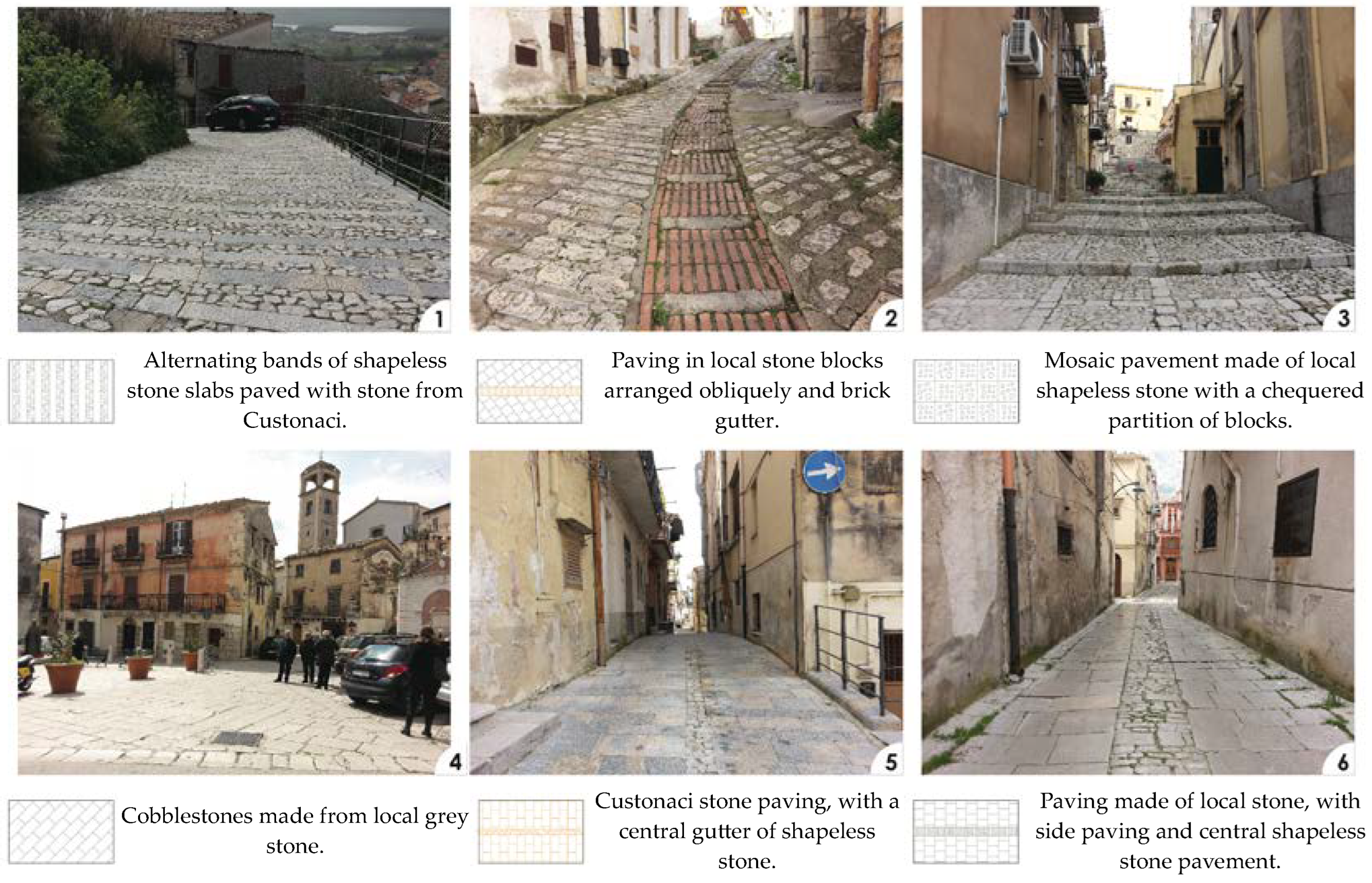
At the urban level, within an inclusive design framework, technical solutions such as assisted steps, ramps, slides, handrails, parking spaces, and urban lifts and elevators provide a response to an existing situation (particularly in existing urban contexts). In this context, paved surfaces can act as aids or barriers for both walking and driving. The roughness and color of the pavement can guide orientation and wayfinding. An example of this is the LOGES(Linea di Orientamento Guida E Sicurezza) system that uses tactile-plantar sensation and kinesthetic sense in order to indicate ground unevenness or potential danger. In addition, the surface can influence walkability in relation to natural and artificial light and become an element of danger, depending on the installation details, e.g., in connections of elevations across inclined planes or the juxtaposition of different materials. In various historical pavements, attention to detail can be found to ensure adequate posture and simplified orientation with morphological expedients (Figure 1) (also with the inclusion of natural guides, tactile-plantar tracks, junctions, and platforms, etc.), or through the use of colorimetry, with attention to contrasts and the size and texture of the paving elements (diagonal, longitudinal, box-shaped, etc.) [23].

Figure 1.
Examples of paving in the historic center of Piana Degli Albanesi (PA). Note the use of traditional materials (19th century and later) and workmanship and textures suitable for the conditions of use, e.g., non-slip finishes for steep slopes (Image processed by Architect Giuseppa Nocera).
We must also note how the use depends on the characteristics of the routes—including dimensional (e.g., width) and morphological (e.g., incline) aspects which are linked to the topography of the terrain, but also on technical aspects (e.g., brightness) that affect safety and fall hazards and, again in terms of road safety, on any interference between roadways, cycle paths, and pedestrian paths.
Planning should favor active mobility, such as walking and cycling, i.e., low-cost and zero-emission forms of mobility which can also provide health co-benefits associated with more active lifestyles. This is also in favor of an alternative vision of the new forms of micro-mobility (scooters, hoverboards, electric bikes, and scooters) that inevitably lead to more vulnerable road users on city streets, an issue that is still under-developed in terms of road safety awareness and education. In the case of urban vehicular mobility, it is preferable to incentivize the use of small, environmentally friendly electric vehicles, including for public transport and MSW collection services (there are also electric microcars for the disabled, with wheelchairs and cargo or combined passenger and goods transport), by providing suitable charging stations and parking areas. Rural electric vehicles (pickup type) for shared use are also available. Lastly, another aspect relates to information and communication: residents must be involved in the mobility planning process from the beginning and be constantly informed about the possibilities that an urban context can offer in terms of services. It is important to provide info-mobility points for this purpose.
4. Experimentation: Case Studies of Sustainable Mobility in Small Urban Centers with a Strong Historical Connotation
The Integrated Laboratory for Sustainable Housing in the Department of Architecture of the University of Palermo has addressed urban centers that maintain a strong historical authenticity but which have among them very different specificities of geographical and economic marginality. Three urban centers, namely, San Mauro Castelverde, Erice Vetta, and Piana degli Albanesi, were considered with regard to the issues of urban accessibility, mobility, and accessibility of buildings. Recently, the research team tested the method on two other historic centers in Sicily: Mistretta (ME) and Vita (TP).
Even when conforming to the context scenario, the measures most often apply to road, rail, and cycle-pedestrian networks. Actions are guided by the aim of recovering historical connection networks (historic roads, trails, etc.) and new, slow mobility modes of public transport (electric buses, rack and pinion railways, and funicular railways) in suburban areas. Again, inter-modal mobility is proposed, especially in the country–city urban-historic–fabric relationship through the identification of points of exchange between modes and car parks, electric shuttle minibus services, and small-scale hectometric systems (rack and pinion railways, funicular railways, mini-metros) for slopes and as support for almost exclusively pedestrian routes.
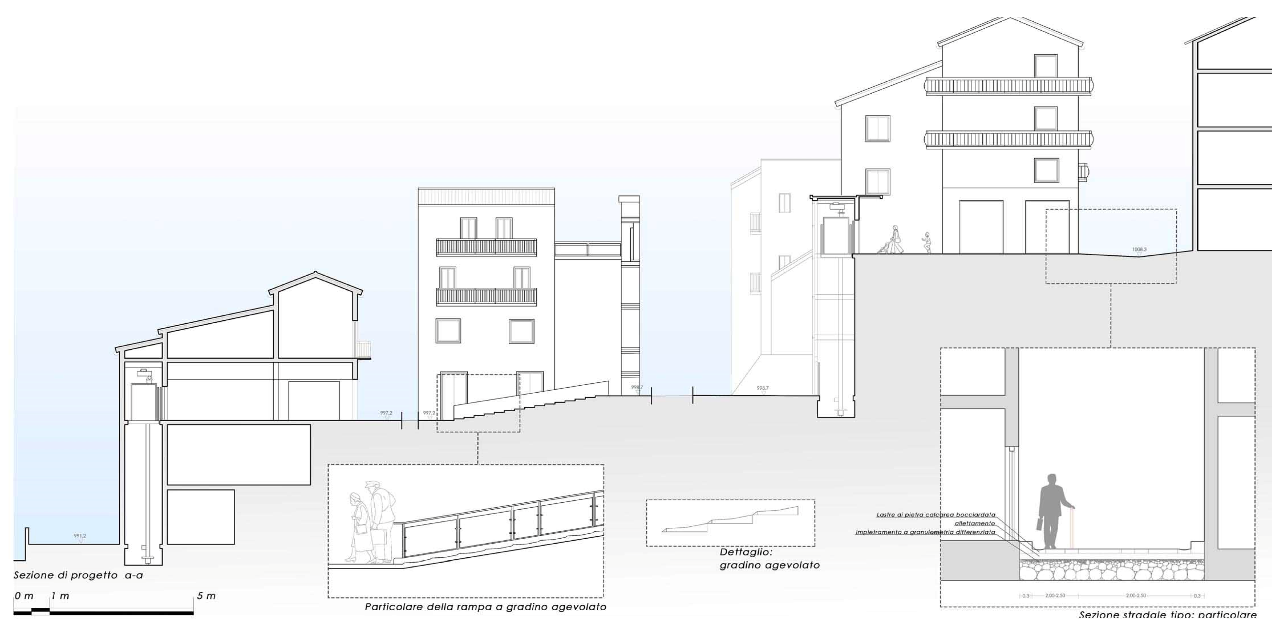
San Mauro Castelverde, in the province of Palermo, belongs to the territory of the Alte Madonie, in the regional park from which it takes its name. It is located at 1050 m above sea level and is about 22 km from the coast. In geographical terms, and also in terms of infrastructure, it is somewhat on the margins of the Madonie itself, suffering from a kind of regional marginalization. Its settlement and cultural characteristics are also partly influenced by its proximity to the Sicilian region’s other major regional park, which is named after the Nebrodi mountain range. Particular attention has been paid to the design of pedestrian-assisted paths, with stepped ramps, lifts, and urban elevators (Figure 2), and intermediate spaces for rest and reflective pleasure. There is also consideration of vehicle-accessible routes (e.g., small electric vehicles to be shared through sharing services, slow and green vehicle systems with devices such as eco bikes, segways, etc.), selective traffic capacity (in terms of types of vehicles and timetables, loading and unloading of goods, etc.), and area traffic capacity, according to principles of subsidiarity and reciprocity between neighboring centers, for the provision of services such as separate MSW collection and school transport [24]. Physical intervention in the historic center, which still retains some recognizable characteristics, is minimal; therefore, a mobility service aided by the use of on demand tools is envisioned.

Figure 2.
Proposed sustainable traffic systems in the city center: detail of lift, handrail, and ramp with facilitated step (Image prepared by Arch. Sofia Venezia).
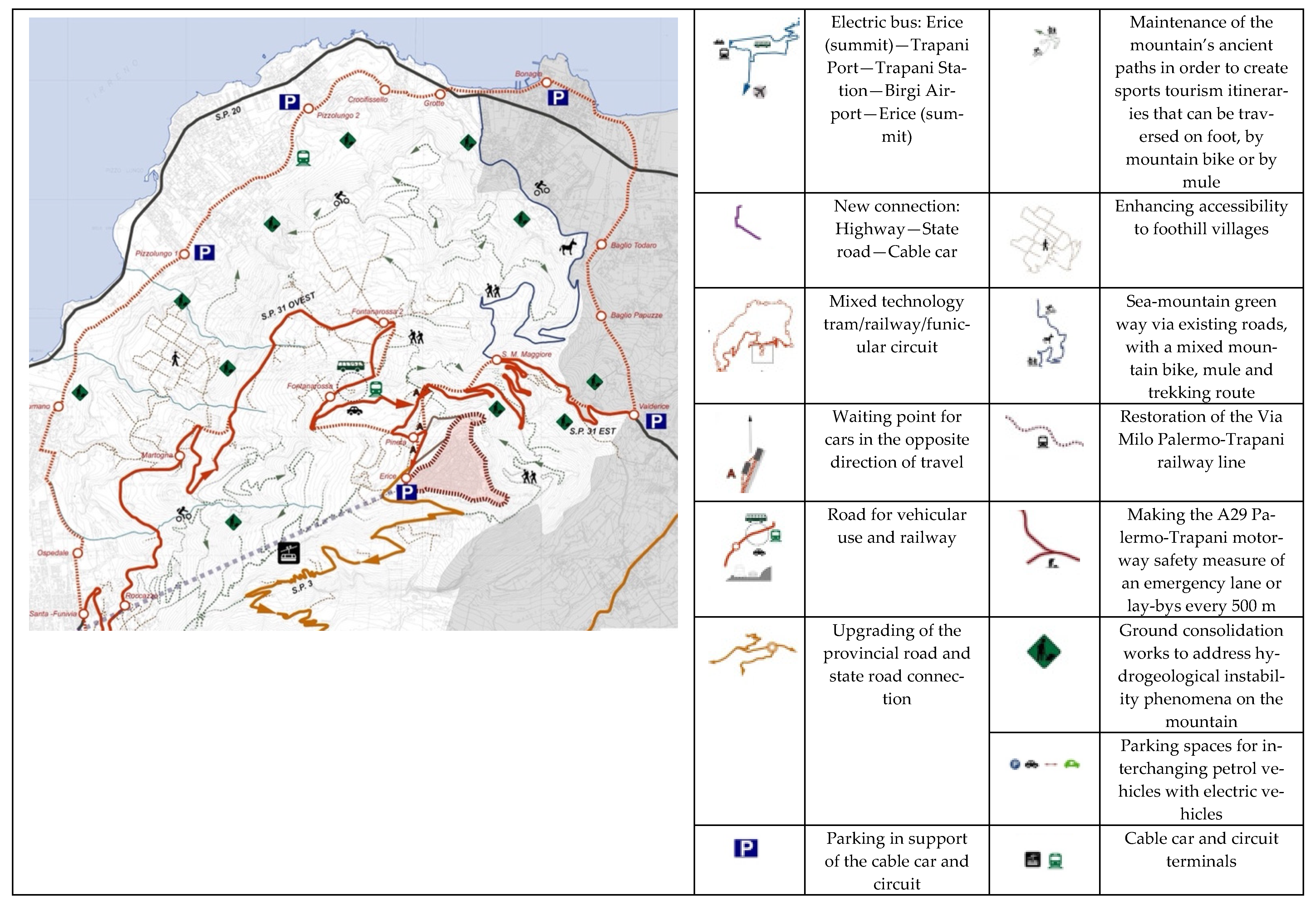
Erice Vetta, in the province of Trapani, is the historic center at the summit of the municipality of Erice, whose administrative territory also extends to the plain and the city of Trapani. Situated at 751 m above sea level, it is still distant from the coast and can be reached by two roads from Valderice and Trapani and by a recently renovated historic cable car. The center, very attractive from a tourism point of view, suffers from almost total neglect in autumn and winter. The aim of the research conducted on a case study such as Erice was to make the historic center a place that would be attractive again as a residential area, facilitating travel on a territorial and urban scale [25]. On a territorial scale, in order to facilitate rapid connections with the surrounding area, the following are planned: an electric bus line connecting the summit with the main inter-modal mobility infrastructures (port, station, and airport) and a new junction to decongest traffic in the built-up area; and the construction of a mixed technology tram/railway/funicular circuit and a greenway through the upgrading of existing roads, in order to create a mixed mountain bike/mule track, thus creating a direct sea-mountain connection (Figure 3).
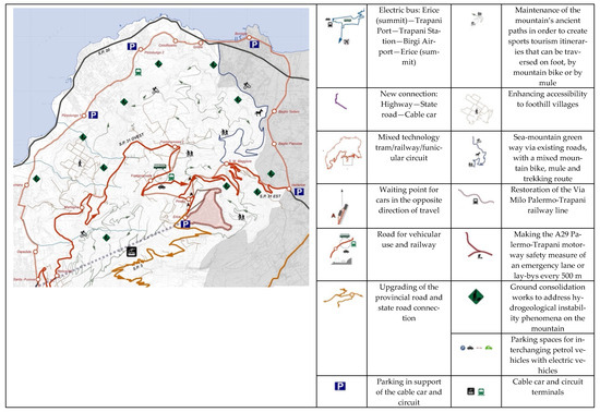
Figure 3.
Proposed sustainable territorial road system. On the right side is a list of the strategic actions intended to improve links between the center of Erice and the surrounding area, i.e., by sea, airport, station, city of Trapani (Image prepared by Arch. Chiara Maria Stabile).
The project also includes the maintenance of the mountain’s ancient paths in order to create more sports tourism itineraries, and the securing of the area by means of ground consolidation works to tackle hydrogeological instability.
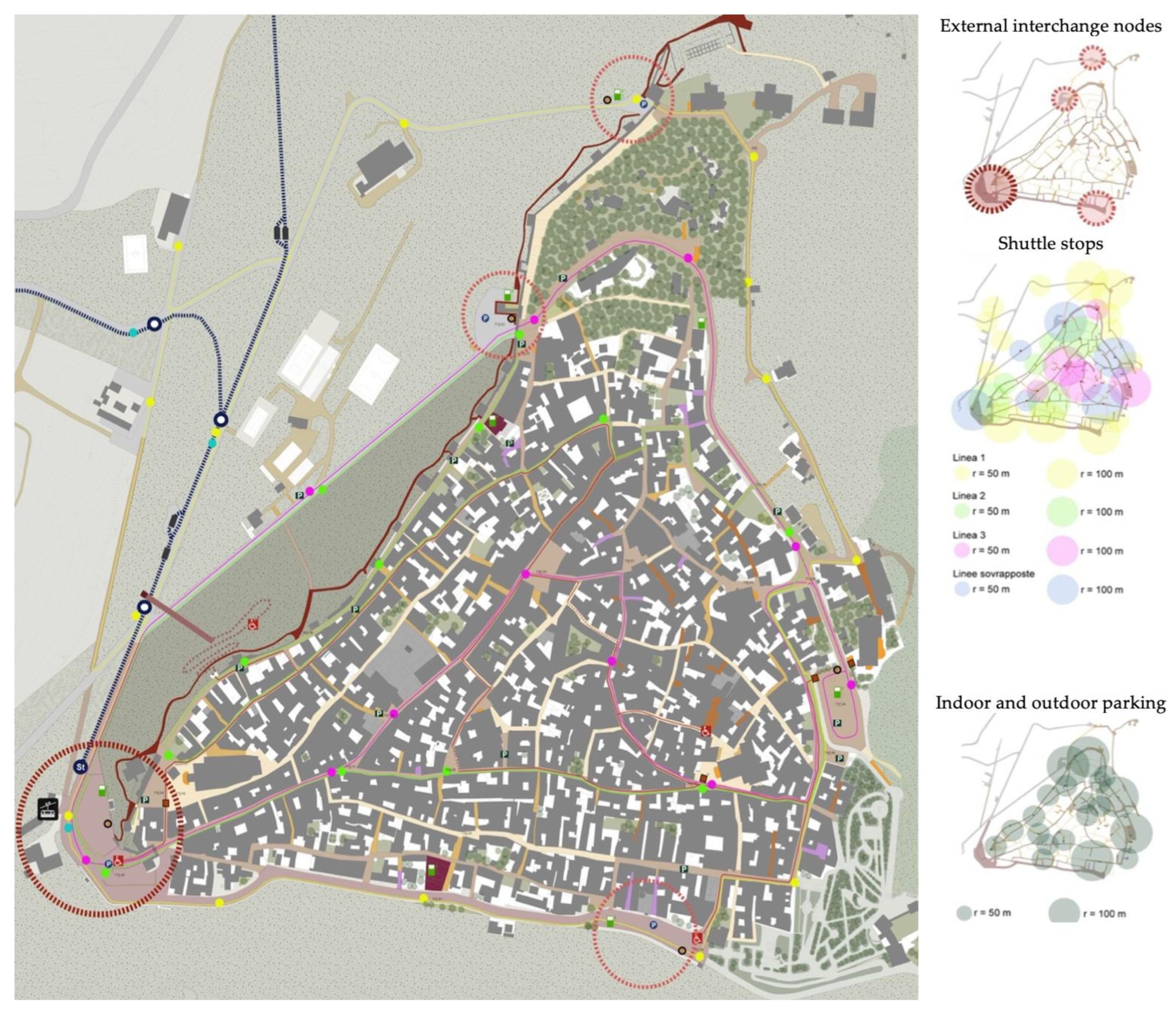
On an urban scale, in the historic center, the project focuses on sustainable mobility by providing accessibility for mobility-restricted users. It plans to abolish the transit of petrol/diesel vehicles within the historic center, which can be parked in extra moenia interchange areas, as well as terminals for buses coming up from the valley. Within the village, it becomes possible to move around in small electric vehicles which are adapted to the maneuvers required by the narrow road sections of the streets in the center. Parking areas, recharging points, and areas for the storage and maintenance of these vehicles are identified to support electric vehicles (Figure 4).

Figure 4.
Proposed sustainable road system in the city center. Depicted are the intermodal parking areas adjacent to the old city walls for wheelchair and mobility scooter users, as well as the stops and the radii of influence of public transport lines (Image prepared by Arch. Chiara Maria Stabile).
Assisted routes, where the physical conditions of the road layout require it, are provided for mobility-restricted users by means of assisted steps and lifting platforms. These routes are partly located in the main streets to enable mobility-restricted users to access the services and shops located there. Handrails are provided along the traditional steps that connect the uneven terrain between one street and another. Finally, the project includes the paving of some streets that are still tarred or unpaved with basalt paving and the maintenance of the remaining streets with historical paving.
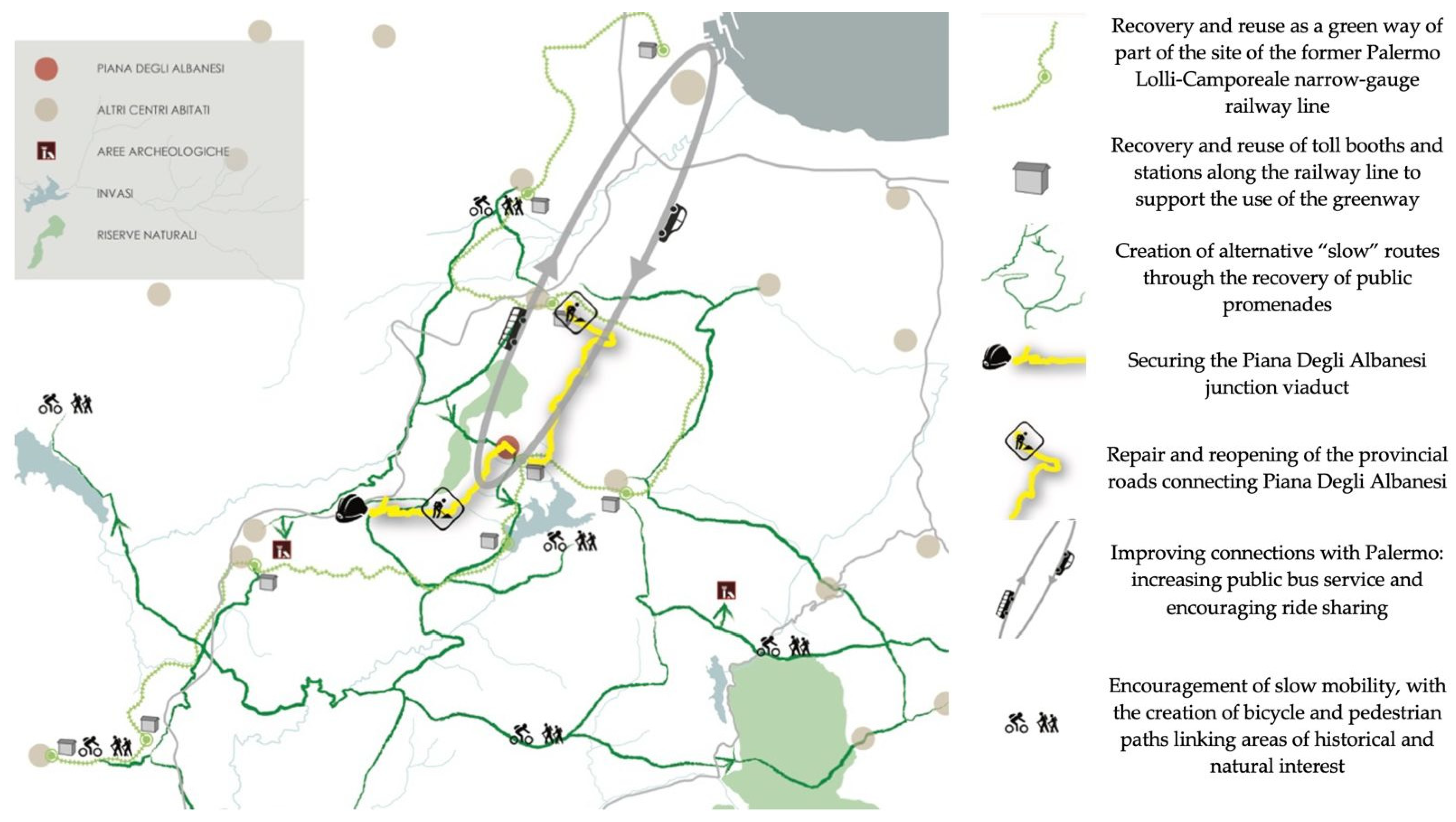
Piana degli Albanesi is a town a few kilometers from Palermo located at 740 m above sea level. It is a center of Arbëreshë or Italo-Albanian culture, together with the neighboring village-sized center of Santa Cristina Gela. Given its proximity to the city of Palermo, it tends toward commuter culture, despite the fact that its transit links, due also to its topography and climate, are limited. Urban throughways are narrow and composed of stairways (shkallët) and micro-neighborhoods (gjitonì). The urban space is a place of gathering in front of houses. The streetscape of the central area consists of large, irregular plots and a late medieval, often bumpy, curvilinear street pattern with stepped ramps. Within the historical center, about 40 per cent of the streets are paved, most of which have been constructed in recent years, perhaps in imitation of the historical ones, which are made of a local, gray-colored stone (called “scescit stone”) that is no longer quarried.
The road network in the historic center was assessed with the aims of recovering urban identity and guaranteeing the accessibility of space. It was then re-evaluated in order to subdivide routes according to their physical features (gradients and road sections). Exclusively pedestrian routes, driveways suitable for small vehicles, and local roads outside the historic center were envisioned. The actions envisaged [26] in the area (Figure 5) aim at a reorganization of mobility and both a link between and enhancement of the natural and cultural heritage through the repair and reopening of provincial roads and the improvement of links with the Sicilian capital, Palermo, by providing for the use of electric buses and encouraging of ride sharing. The plan also envisages the construction of bicycle and pedestrian paths that connect areas of historical and natural interest, through the recovery of state-owned tracks and the reclamation and reuse of parts of the former railway line as a greenway.
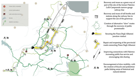
Figure 5.
Proposed sustainable territorial road system. On the right is a list of strategic actions to improve the routes and territorial relations of the center of Piana degli Albanesi with the city of Palermo, the rural areas, and the lake (Image prepared by Arch. Giuseppa Nocera).
The proposed interventions in the urban area are aimed at promoting sustainable mobility and ensuring accessibility for all; they consist of the subdivision of routes within the historic center according to its physical features. This would be achieved through following measures: the identification of pedestrian and/or vehicular routes which are suitable for small vehicles and the realization of facilitated routes which overcome architectural barriers (by means of assisted steps, lifts, etc.); the minimization of traffic at the urban level by providing a ring road for fast flow; the realization of a small-scale rack and railway lift system along the main street; the provision of interchange car parks near the main entrances to the town, where private vehicles can be left and electric minicars, bicycles, or other eco-friendly vehicles can be rented; and the construction of parking and charging areas for electric vehicles.
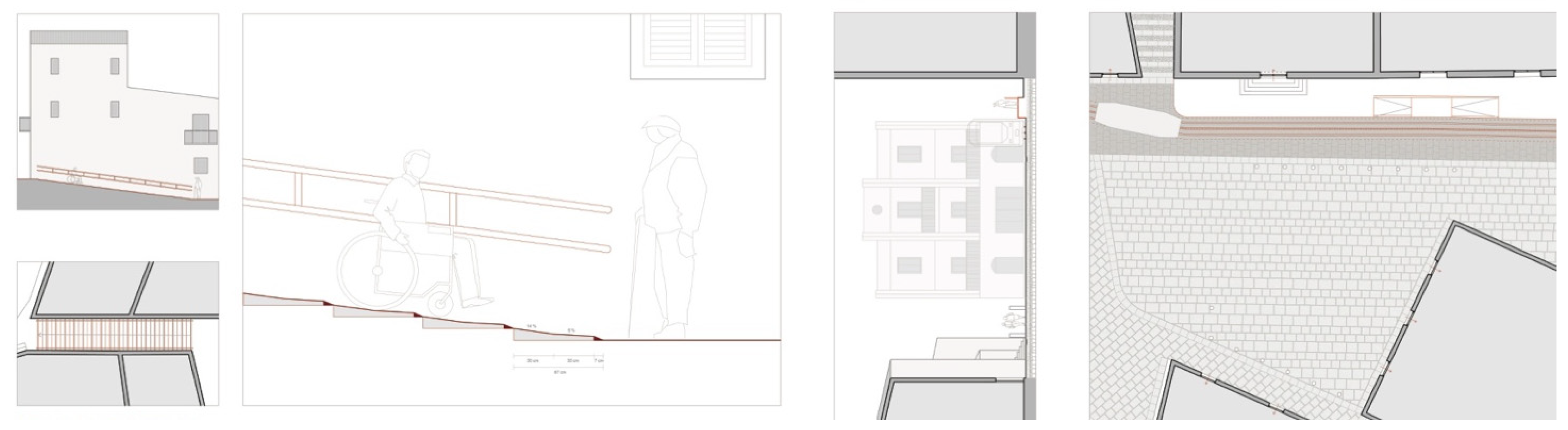
An assisted route within the historic center has been provided to ensure accessibility for people who are elderly, disabled, or have children in prams in areas where there are steep slopes or stepped ramps. In particular, in spaces where there are differences in height of more than three meters, it is foreseen that outdoor lifts will be placed within abandoned sites. Meanwhile, ramps and stairways with moderate height differences have been redesigned as easy-step ramps that can also be used by wheelchair users (Figure 6).
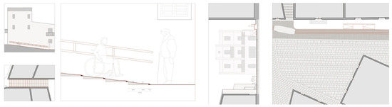
Figure 6.
Proposed sustainable road system in the city center: detail of ramp with assisted steps (Image prepared by Arch. Giuseppa Nocera).
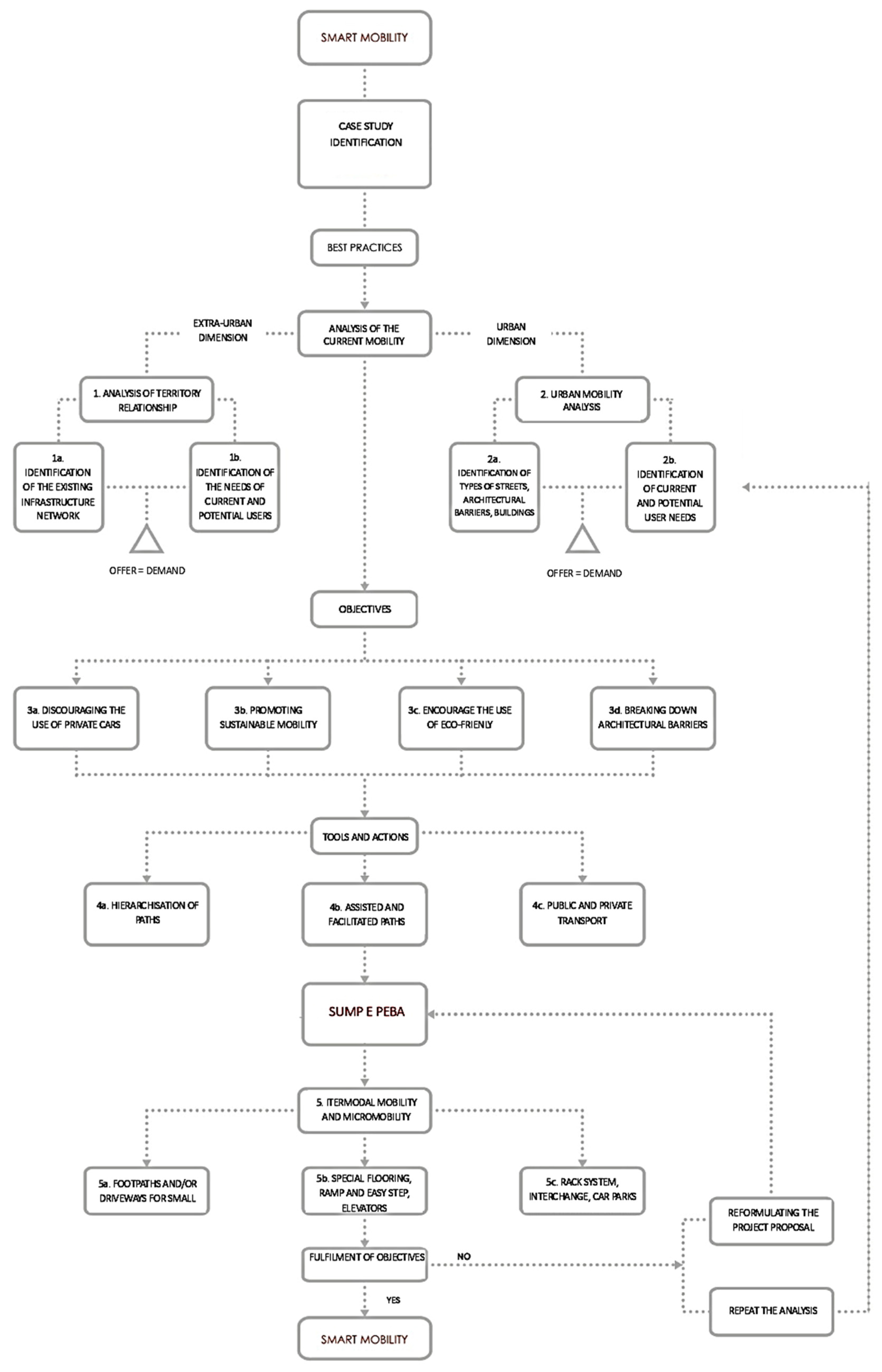
5. Conclusions
The design choices and the proposed sustainable mobility measures stem from a number of fundamental objectives that were set in order to solve the problems encountered in the study and analysis phase of the project. All three centers are significantly defined by their still evident historical urban fabric and physical features. The settlements are greatly influenced by their topographies, which not only contribute to their scenic appeal but also to their infrastructural difficulties. Urban mobility has to reckon with considerable inclines in roadways and elevation jumps. The issue of links to hubs and major infrastructure, the complications presented by the topography, and the settlement incline distributions unite all three settlements to varying degrees.
In spite of the morphological complexity of the areas examined, it was possible to demonstrate the concrete possibility of implementing a sustainable mobility plan consisting of a few targeted measures aimed at improving the livability and increasing the attractiveness of these small urban centers. Among the various cases, common reflections clearly emerged. Firstly, one cannot speak reductively, i.e., only of accessibility measures. Rather a design ‘for all’, coordinated with urban planning and spatial development dynamics, is required. Secondly, the project can only be carried out with interdisciplinary collaborations and, moreover, with strong relationships with council administrations on the one hand, and with disability organizations on the other. The presented solutions propose an idea of large-scale accessibility that intends to lay the foundations for the construction of a new social conscience regarding a comfortable and safe reachability and the usability of such places, including as large a number of users as possible. The design outcomes that were established, from the resolution of critical issues in the historic centers to the redevelopment of urban spaces, are part of an overall framework that begins with a general study of the territory, the historic centers, the common and unique accessibility conditions, the precise identification of problems in the identified routes, and finally, a design proposal. Fulfilling the requirement of accessibility in a historic urban fabric requires the adoption of a strategic management approach guided by a multi-dimensional and multi-scalar vision, which allows management, social, cultural, morphological, and regulatory aspects to be taken into account. The contribution to accessibility provided by this work provides a tool to start the planning process, increase proposals, and implement concrete measures (see Figure 7).
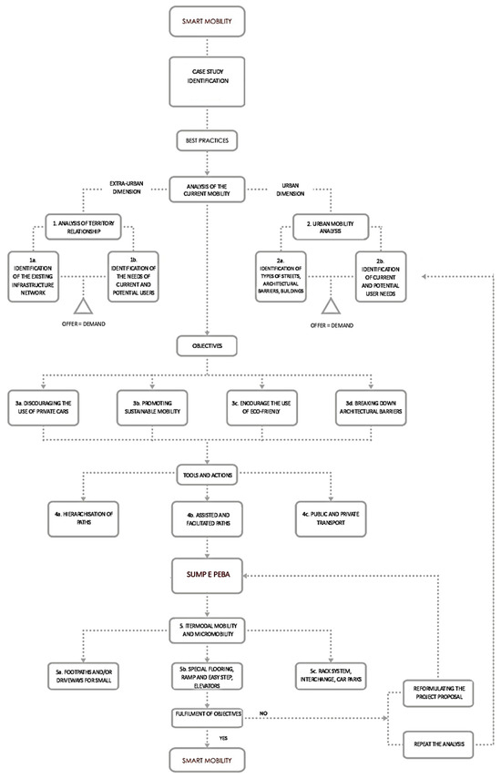
Figure 7.
Flow chart illustrating the methodology of the design and plan choices (Image prepared by Arch. Giuseppa Nocera and Prof. Elvira Nicolini and Prof. Antonella Mamì and Arch. Sofia Venezia and Arch. Chiara Maria Stabile).
The methodology described here is replicable in many other historic centers that have similar characteristics, i.e., historic buildings and street fabric, steep slopes, traditional paving, and the presence of stairs and narrow streets.
The method is not only an aid to planning choices, but also a decision-making tool for local administrators.
Recently, the research team tested the method on two other historic centers in Sicily: Mistretta (ME) and Vita (TP). It is almost always the case that in historic centers, the constraints and difficulties are similar, therefore allowing the same methodology to be applied, albeit with contextualized solutions.
The gamble lies in the involvement of local administrations and the participation of citizens, in terms of their willingness to pursue and concretely implement what is currently only a strategic vision for the regeneration and realization of potentially virtuous communities.
Funding
This research received no external funding.
Institutional Review Board Statement
Not applicable.
Informed Consent Statement
Not applicable.
Data Availability Statement
Not applicable.
Acknowledgments
Venezia S., Stabile M.C. and Nocera G. have conducted work under the supervision of Mamì A. and Scavone V., who is acknowledged for his valuable contribution; together with Stabile M. C., we also thank Arch. Prestìa G., Co-Supervisor. The maps shown are entirely reworked by the research team using as a basis official maps produced, or made available, by the Region of Sicily.
Conflicts of Interest
The author declare no conflict of interest.
References
- Parliament and European Council. European Green Deal. Available online: https://www.consilium.europa.eu/it/policies/green-deal/ (accessed on 8 June 2023).
- Rupprecht, S.; Brand, L.; Böhler-Baedeker, S.; Brunner, L.M. Guidelines for Developing and Implementing a Sustainable Urban Mobility Plan; European Platform on Sustainable Urban Mobility Plans; Rupprecht Consult-Forschung und Beratung GmbH: Koln, Germany, 2019. [Google Scholar]
- Italian Republic. Decree of the Ministry of Infrastructure and Transport of 4 August 2017 on “Identification of Guidelines for Urban Sustainable Mobility Plans, Pursuant to Article 3(7) of Legislative Decree No 257 of 16 December 2016”. Available online: https://www.gazzettaufficiale.it/eli/id/2017/10/05/17A06675/sg (accessed on 10 June 2023).
- Parliament and European Council. Communication from the Commission to the European Parliament, the Council, the European Economic and Social Committee and the Committee of the Regions. In The New EU Framework for Urban Mobility; Official Journal of the European Union: Brussels, Belgium, 2021. Available online: https://eur-lex.europa.eu/legal-content/IT/TXT/HTML/?uri=CELEX:52021DC0811&from=EN (accessed on 8 June 2023).
- Conti, C.; Cioci, S.; Sambrotta, T. Beyond the Norm, the PEBA to Live in Udine. Stud. Health Technol. Inform. 2022, 297, 255–262. [Google Scholar] [PubMed]
- Pflieger, G. The local politics of Europeanization: A study of French cities’ approaches to participation in the CIVITAS programme. Eur. Urban Reg. Stud. 2014, 21, 331–344. [Google Scholar] [CrossRef]
- Parliament and European Council. Communication from the Commission to the European Parliament, the Council, the European Economic and Social Committee and the Committee of the Regions. In Strategia per una Mobilità Sostenibile e Intelligente: Mettere i Trasporti Europei sulla Buona Strada per il Futuro; Official Journal of the European Union: Brussels, Belgium, 2020. Available online: https://eur-lex.europa.eu/resource.html?uri=cellar:5e601657-3b06-11eb-b27b-01aa75ed71a1.0005.02/DOC_1&format=PDF (accessed on 8 June 2023).
- Bezerra, B.S.; dos Santos, A.L.L.; Delmonico, D.V. Unfolding barriers for urban mobility plan in small and medium municipalities–A case study in Brazil. Transp. Res. Part A Policy Pract. 2020, 132, 808–822. [Google Scholar] [CrossRef]
- Bahn, D.; Marcy, M.; Vaillancourt, K.; Waaub, J.P. Electrification of the Canadian road transportation sector: A 2050 outlook with TIMES-Canada. Energy Policy 2013, 62, 593–606. [Google Scholar] [CrossRef]
- Marletto, E.G.; Mameli, F. A participative procedure to select indicators of policies for sustainable urban mobility. Outcomes of a national test. Eur. Transp. Res. Rev. 2012, 4, 79–89. [Google Scholar] [CrossRef]
- Mateo-Babiano, I.F.; Bean, R.; Corcoran, J.; Pojani, D. How does our natural and built environment affect the use of bicycle sharing? Transp. Res. Part A Policy Pract. 2016, 94, 295–307. [Google Scholar] [CrossRef]
- Italian Republic. Law No 41 of 28 February 1986 Art. 32 p. 21, Provisions for the Formation of the Annual and Multi-Year State Budget (Financial Law ‘86). Available online: https://www.gazzettaufficiale.it/eli/gu/1986/02/28/49/so/13/sg/pdf (accessed on 10 June 2023).
- Italian Republic. Law No 104 of 5 February 1992 Article 24 p. 9, Framework Law for Assistance, Social Integration and the Rights of Disabled Persons. Available online: https://www.gazzettaufficiale.it/eli/id/1992/02/17/092G0108/sg (accessed on 15 June 2023).
- Lauria, A. Regenerating villages in the inner areas through cultural and experiential tourism. Valori Valutazioni 2022, 30, 101–117. [Google Scholar] [CrossRef]
- Scavone, V.; Sinatra, M.; Venezia, S. Centri storici e Smart Town: Mobilità sostenibile e infrastrutture virtuali. In Recupero, Valorizzazione, Manutenzione nei Centri Storici. Un Tavolo di Confronto Interdisciplinare; Castagneto, F., Fiore, V., Eds.; Lettera Ventidue Edizioni, Siracusa; Lettera Ventidue Edizioni: Siracusa, Italy, 2013; pp. 254–257. [Google Scholar]
- Arenghi, A.; Garofolo, I.; Lauria, A. Accessibility as a design resource for the enhancement of lesser-known cultural sites from the perspective of tourism. In Conservation—Reconstruction. Small Historic Centres. Conservation in the Midst of Change; Crisan, R., Fiorani, D., Luoghlin, K., Musso, S.F., Eds.; EAAE: Hasselt, Belgium, 2015; pp. 409–415. [Google Scholar]
- Mamì, A. Centri a forte connotazione nell’entroterra dell’Italia meridionale: Ripensare la città tra valori, vincoli fisici e opportunità tecnologiche. In Un Paese Ci Vuole. Studi e Prospettive sui Centri Abbandonati e in via di Spopolamento; ArcHistoR, extra 7, supplement to issue 13/2020; Mediterranea University of Reggio Calabria: Reggio Calabria, Italy, 2020; pp. 948–965. [Google Scholar]
- Werland, S. Diffusing sustainable urban mobility planning in the EU. Sustainability 2020, 12, 8436. [Google Scholar] [CrossRef]
- Mamì, A. Centri storici e Smart Town: I centri minori come laboratori di nuova residenzialità sostenibile. In Recupero Valorizzazione Manutenzione nei Centri Storici; Castagneto, F., Fiore, V., Eds.; Lettera Ventidue: Siracusa, Italy, 2013; pp. 250–253. [Google Scholar]
- Pane, A.; Russo, V.A. Questioni di accessibilità in un piccolo centro storico: Il caso del quartiere Ciroppolo a Vietri sul Mare. In Abitare Inclusivo. Il Progetto per una Vita Autonoma e Indipendente; Baratta, A.F.L., Conti, C., Tatano, V., Eds.; Anteferma Edizioni: Conegliano, Italy, 2019; pp. 102–111. [Google Scholar]
- European Parliament and Council. Final Report of the Single Platform for Open Road Testing and Pre-Deployment of Cooperative, Connected and Automated and Autonomous Mobility Platform (CCAM Platform), 2021. Available online: https://transport.ec.europa.eu/system/files/2021-11/Final%20Report-CCAM%20Platform.pdf (accessed on 8 June 2023).
- European Union Aviation Safety Agency. Study on the Societal Acceptance of Urban Air Mobility in Europe; European Union Aviation Safety Agency: Cologne, Germany, 2021.
- Conti, C. Percorsi inclusivi in contesti storici: Il ruolo delle superfici. In L’accessibilità nel Patrimonio Architettonico. Approcci ed Esperienze tra Tecnologia e Restauro; Germanà, M.L., Prescia, R., Eds.; Anteferma: Treviso, Italy, 2021; pp. 178–185. [Google Scholar]
- Venezia, S. San Mauro Castelverde Smart Town? Proposte di Mobilità Sostenibile per la Riqualificazione Urbana. Master’s Thesis, Master’s Degree in Architecture. University of Palermo, Palermo, Italy, 2012. [Google Scholar]
- Stabile, M.C. Erice Smart Town? Ipotesi di Mobilità Sostenibile. Master’s Thesis, Master’s Degree in Architecture. University of Palermo, Palermo, Italy, 2016. [Google Scholar]
- Nocera, G. Piana Degli Albanesi Smart Town? Proposte per una Mobilità Sostenibile. Master’s Thesis, Master’s Degree in Architecture. University of Palermo, Palermo, Italy, 2015. [Google Scholar]
Disclaimer/Publisher’s Note: The statements, opinions and data contained in all publications are solely those of the individual author(s) and contributor(s) and not of MDPI and/or the editor(s). MDPI and/or the editor(s) disclaim responsibility for any injury to people or property resulting from any ideas, methods, instructions or products referred to in the content. |
© 2024 by the author. Licensee MDPI, Basel, Switzerland. This article is an open access article distributed under the terms and conditions of the Creative Commons Attribution (CC BY) license (https://creativecommons.org/licenses/by/4.0/).