Review

The Role of Urban Vegetation in Mitigating Fire Risk Under Climate Change: A Review

College of Architecture and Urban Planning, Tongji University, Shanghai 200092, China
*
Author to whom correspondence should be addressed.
Sustainability 2025, 17(6), 2680; https://doi.org/10.3390/su17062680
Submission received: 20 February 2025 / Revised: 5 March 2025 / Accepted: 12 March 2025 / Published: 18 March 2025

Abstract

:
The confluence of global warming, the urban heat island effect, and alterations in the nature of underlying surfaces has led to a continuous escalation in the frequency, scale, and intensity of fires within urban green spaces. Mitigating or eliminating the adverse effects of such fires on the service functions of urban ecosystems, while enhancing the resilience of urban greening systems in disaster prevention and risk reduction, has become a pivotal challenge in modern urban development and management. Academic focus has progressively broadened from isolated urban and forest domains to encompass the more intricate environments of the Wildland–Urban Interface (WUI) and urban–suburban forests, with a particular emphasis on the distinctive characteristics of urban greening and in-depth research. This study employs a combination of CiteSpace bibliometric analysis and a narrative literature review to comprehensively examine three critical aspects of urban fire safety as follows: (1) the evaluation of the fire-resistant performance of landscape plants in urban green spaces; (2) the mechanisms of fire behavior in urban greening systems; and (3) the assessment and prediction of urban fire risks. Our findings indicate that landscape plants play a crucial role in controlling the spread of fires in urban green spaces by providing physical barriers and inhibiting combustion processes, thereby mitigating fire propagation. However, the diversity and non-native characteristics of urban greenery species present challenges. The existing research lacks standardized experimental indicators and often focuses on single-dimensional analyses, leading to conclusions that are limited, inconsistent, or even contradictory. Furthermore, most current fire spread models are designed primarily for forests and wildland–urban interface (WUI) regions. Empirical and semi-empirical models dominate this field, yet future advancements will likely involve coupled models that integrate climate and environmental factors. Fire risk assessment and prediction represent a global research hotspot, with machine learning- and deep learning-based approaches increasingly gaining prominence. These advanced methods have demonstrated superior accuracy compared to traditional techniques in predicting urban fire risks. This synthesis aims to elucidate the current state, trends, and deficiencies within the existing research. Future research should explore methods for screening highly resistant landscape plants, with the goal of bolstering the ecological resilience of urban greening systems and providing theoretical underpinnings for the realization of sustainable urban environmental security.

1. Introduction

Urban fires are posing significant challenges to city resilience and safety, particularly in the context of climate change. As the Earth’s temperatures continue to rise, the frequency and intensity of extreme weather events have increased, exacerbating the risk of urban fires [1]. For instance, between 2003 and 2023, the global frequency of extreme fire events has escalated to 2.2 times its original rate, and the average intensity of major fires has risen to 2.3 times its previous level [2].
Climate change is intensifying compound climate events, characterized by high temperatures and heatwaves, as well as droughts and scant rainfall. This leads to a reduction in the air’s relative humidity and frequent occurrences of strong convective weather that influences lightning strikes and strong winds. These factors result in an increase in the severity and aridity of fire weather conditions and the extension of the fire season, underscoring the need for robust urban planning and resilience strategies [3].
The interplay between hotter temperatures, prolonged droughts, and unpredictable weather patterns results in conditions that are more conducive to fires. Complex topography and an ecologically sensitive environment contribute to urban areas being increasingly susceptible to the effects of climate change, especially those with dense populations and a complex spatial composition [4]. Recent incidents, such as the devastating wildfires in California and Australia, highlight the pressing need to address these risks. These events lead to the loss of life and property, as well as long-term social and economic impacts. Furthermore, fire is anticipated to have exerted a negative impact on the ecological integrity and verdancy of urban environments, and it has further contributed to climate conditions by increasing both direct and indirect carbon emissions, leading to exacerbated global warming, air pollution, and biodiversity loss [5].
The suburb areas are especially vulnerable, as they combine natural vegetation with human development, increasing the likelihood of fire spread. Consistent with these findings are fire rescue statistics from 36 countries, which indicate that 27.9% of urban fires occur in urban forests, green spaces, and lawns [6]. Outdoor places, particularly vegetation, are increasingly becoming the primary source of urban fire hazards, underscoring the need for strategic urban planning and fire prevention measures.
The increasing risk and severity of urban vegetation fires highlight the need for proactive measures in urban planning. Developing comprehensive strategies that incorporate climate projections, fire risk assessments, and vegetation management can significantly reduce the vulnerability of urban areas to fire threats [7]. By prioritizing these strategies, cities can better protect their communities and infrastructure, ensuring a more resilient and sustainable future in the face of climate change.
The necessity for research into urban fires is not only societal but also an academic imperative, highlighting the urgency for innovative solutions that bolster urban resilience [8]. The research domain of urban fire and vegetation is multidisciplinary, encompassing urban landscaping, forestry, ecology, disaster risk reduction, and urban planning. The current research landscape is rich with studies that have dissected various aspects of urban fires and vegetation. Scholars have explored the characteristics of plant species that exhibit fire resistance and their implications for urban greening strategies [9]. The study of urban vegetation’s role in fire behavior, including phenomena like crown fires and surface fires, requires a nuanced understanding of plant flammability and the dynamics of fire spread. However, there is a discernible gap in the comprehensive evaluation of how urban vegetation can be leveraged to mitigate fire risk. While research has delved into the selection of fire-resistant species and the modeling of fire behavior, a holistic approach that integrates these elements within the urban fabric has yet to be fully realized [10].
To recapitulate, urban vegetation plays a dual role, providing essential ecological benefits but also requiring careful management to mitigate fire risk [11]. It provides essential ecological benefits, such as reducing urban heat and improving air quality, but certain types of vegetation can also contribute to fire risk if not properly managed. Policies that focus on urban resilience and sustainable development now emphasize the integration of fire-resistant vegetation into urban planning. This approach not only mitigates fire threats but also supports broader environmental goals. By selecting plants that have a high resistance to fire, cities can enhance their resilience to and recovery from fire events.
This scholarly investigation employed CiteSpace software to systematically organize and visualize the interconnections between urban fire occurrences and vegetational dynamics through a bibliometric approach. Our methodology facilitated a comprehensive literature review, culminating in the identification of 80 highly influential and pertinent academic papers. These publications, recognized for their significant citation counts and relevance, were subjected to an in-depth analysis. The synthesis of these papers allowed for a detailed exposition of the prevailing research trends in three pivotal areas as follows: the assessment of fire resistance among plants in urban landscapes, the examination of fire behavior as it pertains to urban vegetation, and the evaluation and forecasting of fire risk within urban environments.

2. Materials and Methods

2.1. Search Strategy

The dataset employed in this scholarly work is derived from the esteemed Core Collection of the Web of Science, encompassing a spectrum of databases such as the Science Citation Index Expanded (SCI-E), Social Sciences Citation Index (SSCI), Conference Proceedings Citation Index (CPCI), and the Book Citation Index (BkCI). To retrieve the relevant literature for this review, we used a set of keywords consistent with the main topics and research questions investigated (Table 1). These keywords were applied to the topic, title, abstract, and keywords fields in relevant databases. The publication period was “1987–2024”, and the literature types were “article” and “review”. A total of 941 valid references were retrieved for subsequent analysis by de-duplicating and eliminating irrelevant references.

2.2. Data Extraction

The extracted information encompassed the following four categories: (1) background data, including title, journal, author(s), year of publication, and study location; (2) research methods, such as field survey approaches, laboratory measurement techniques, research design, and data sources or collection methods; (3) study variables, including key indicators influencing the fire-resistant capabilities of landscape plants and major factors affecting fire behavior in urban vegetation; and (4) principal research findings. To identify emerging trends, as well as similarities and differences among existing research outcomes, the 80 highly cited and thematically relevant articles selected in this study were further coded, categorized, and summarized based on these four categories.
This study employs CiteSpace software to conduct a visual analysis of the relevant literature pertaining to the research topic, thereby elucidating the developmental patterns and trends within the field.

3. Results

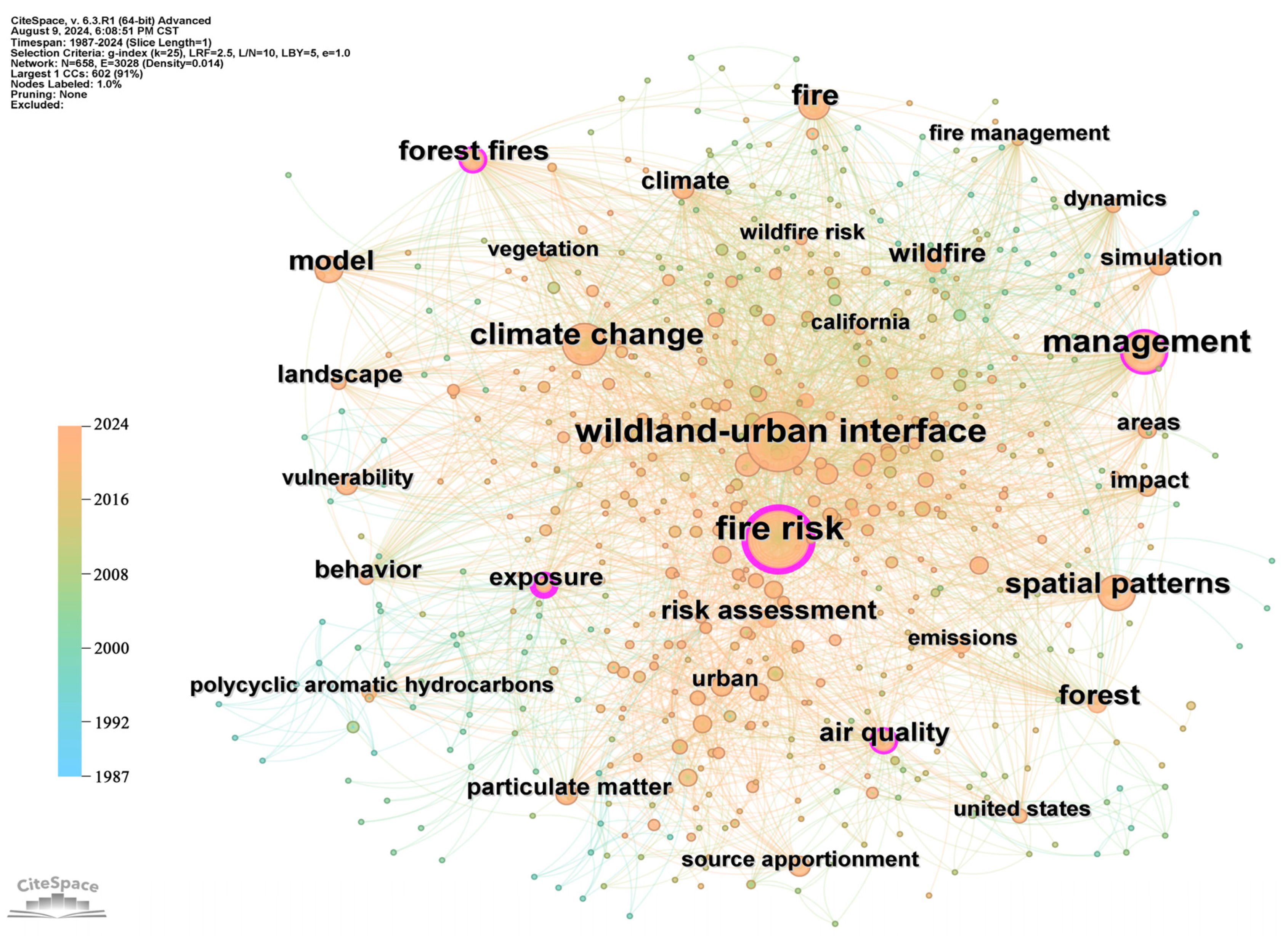
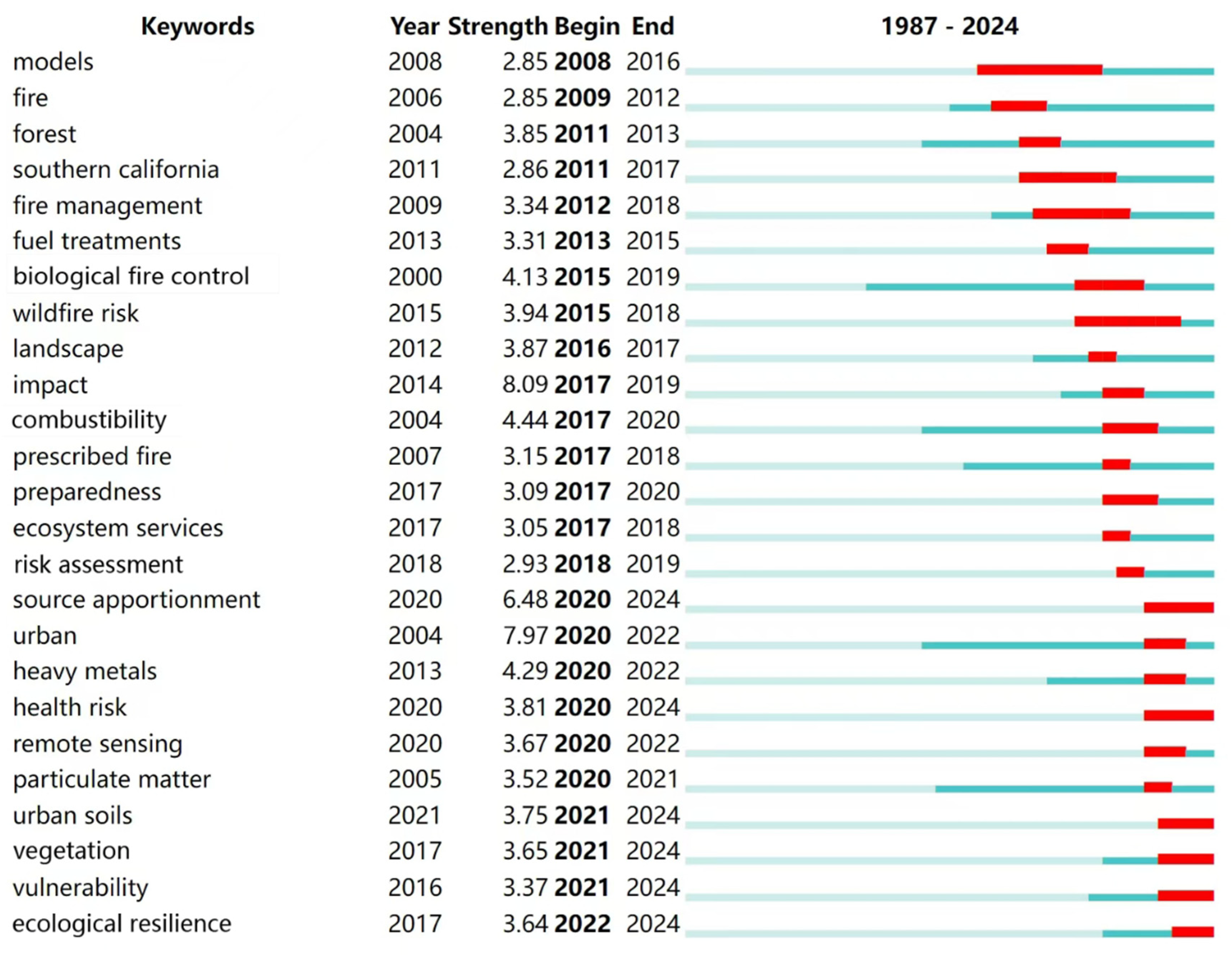
3.1. Research Topic Development Path Analysis

Figure 1 presents a keyword co-occurrence network. The co-occurrence relationships among keywords and network density allow for an exploration of the research themes, content, technologies, and methodologies within pertinent topics of interest. When examining the research subjects, the terms ‘wildland–urban interface’ and ‘fire risk’ exhibit a substantial publication count, indicating a robust interconnection and a pronounced collinearity. Additionally, several nodes serve as bridging elements between distinct clusters, such as ‘management’, ‘behavior’, ‘spatial patterns’, ‘vulnerability’, and ‘exposure’, illustrating the heightened focus on fire risk within the WUI domain. The majority of the literature commences its analysis from fire behavior and spatial patterns [12]. Utilizing disaster system theory, risk factors are identified for the assessment of fire risk within the study’s sample, thereby achieving the objectives of fire risk management. Considering the factors influencing fire, the co-occurrence relationship between ‘climate change’ and ‘fire risk’ is notably strong, with connecting nodes primarily consisting of ‘forest fires’, ‘wildfire’, ‘landscape’, ‘vegetation’, and ‘model’. This underscores the significant influence of drastic climate change on fire risk across forests, wild lands, and urban vegetation [13]. Existing research primarily concentrates on vegetation and landscape plants, frequently employing the construction of virtual models to examine the interplay between meteorological and fire-related factors [14].
Burst terms are identified as keywords exhibiting significant fluctuations, including abrupt alterations or rapid escalations within a brief timeframe, thereby uncovering the ebb and flow of specific research topics (Figure 2). Utilizing keyword cluster analysis in conjunction allows for the reflection of prevailing keywords and the delineation of their mutational patterns within the scope of this research topic (Figure 3).
In the initial phase of research, from 1987 to 1997, the volume of the literature was relatively low, with no significant emergent terms identified. Research during this period concentrated on the primary factors influencing fires and their severe repercussions, placing a significant emphasis on social and economic dimensions [15]. This aligns with the findings from cluster analysis, specifically cluster #7 socio-economic conditions.
The subsequent phase, from 1998 to 2007, marked the commencement of preliminary inquiries into forest and urban fires, during which the volume of the literature began to escalate. Terms such as ‘combustibility’, ‘biological fire control’, and ‘fire management’ made their initial appearance, albeit with subdued intensity, suggesting that research into plant combustion experiments and the identification of fire-resistant flora for fire mitigation was in its nascent stages. This trend is mirrored in the clusters #2 fire management and #10 burning vegetation, with a concurrent surge in publications related to physicochemical, combustion, and thermogravimetric analyses of plants. Species like Schima superba and Taxus baccata are commonly recognized as fitting candidates for planting in zones designed to prevent forest fires [16].
The third phase, extending from 2008 to 2017, after experiencing fire disasters such as the California wildfire event, the research on biological fire prevention and wildfire prevention entered a stage of rapid growth. In this period, there was a notable upsurge in the volume of scholarly articles, an accelerated pace of growth, and an increasing diversification of research foci. The themes that had begun to evolve in the preceding phase continued to advance, encompassing discussions on plant combustibility and fire resistance. The term “impact” (4.44) also rose to prominence, reflecting a growing body of research that has transitioned its focus from social and economic aspects to the ecological ramifications and air quality degradation resulting from wildfires [17,18]. This aligns with the emphasis on “ecosystem services”, denoted by an intensity of 3.05. Additionally, this phase delves into the positive implications of controlled burns on vegetation and ecological health [19]. Research subjects have expanded beyond wildfires to include the broader impact of fires on landscapes, indicating a trend toward the more nuanced discourse on the scale and nature of fire events. This evolution in research scope and focus underscores the complexity and multifaceted implications of fire in ecological and environmental contexts.
The subsequent stage from 2018 to 2024 has shifted the research emphasis to urban areas, underscored by the significant intensity rating of 7.97 for the term “urban,” reflecting this pivotal shift. With the extensive application of satellite remote sensing, computer technology, and information technology within this research domain, urban fire risk assessment and prediction, fire station planning, and the regulation and management of landscape fires have been enhanced through the utilization of remote sensing data and machine learning techniques [20,21]. This aligns with the thematic focus on #3 machine learning and #9 risk assessment. Concurrently, this stage delved deeper into the ramifications of fire on environmental pollution, with a specific focus on air and soil contamination, aligning with the clustering outcomes related to pollution and source apportionment [22,23]. Notably, the term “health risk,” marked by its high emergence, signals an expansion of research to encompass the implications for human habitation, framed within the broader context of a fire’s aftermath. In recent times, urban vegetation fire studies have been dynamically integrated into earlier research on plants that are resistant to fire, which are typically used in forests, wild lands, and the wildland–urban interface (WUI) [24,25,26]. This integration also considers the interplay between fire occurrence and the spatial arrangement of vegetation [12]. The aim is to refresh the conceptual framework and objectives of the research, and to increasingly prioritize the role of urban landscape plants. Additionally, there is a focus on bolstering the resilience of urban ecosystems by enhancing the fire resistance of the vegetation within these areas.
Overall, the trajectory of this field has predominantly transitioned from qualitative analyses to quantitative methodologies, progressing from static disposals of fire’s determinants and repercussions to dynamic evaluations and forecasts of fire propagation and hazards, leveraging remote sensing and innovative methodologies. The scope of research has broadened from encompassing forests and wildlands to include the WUI and urban locales, with observable evidence that climate change and urban development are intensifying the areas affected by fires [4,27]. Plants, as pivotal ecosystem constituents, serve dual roles as both primary combustible sources for fires and as integral to biological fire mitigation strategies. Consequently, plant research remains a prevalent subject within this domain, with sub-topics exploring the attributes and processes that appraise plant fire resistance, including the inherent physiological, chemical, and combustive traits of flora [28,29,30]. Furthermore, the development of a fire behavior model is essential. This model aims to simulate the spread of fire across various types of vegetation, providing a deeper understanding of how different plant species interact with and resist fire spread [31,32]. As the associated disciplines evolve, bolstered by the aggregation of foundational theories and the integration of novel technologies, the scale of research has expanded, transitioning from mesoscopic to encompass both macroscopic and microscopic perspectives. Cross-disciplinary studies in fields like geography, ecology, meteorology, forestry, and landscaping are demonstrating a trend toward greater depth and complexity.

3.2. Evaluation Method of Plant Fire Resistance

Fire-resistant plants are generally defined as those that can effectively decrease the rate and intensity of flame propagation during a fire event, thereby playing a pivotal and indispensable role in curbing the spread of the fire. Currently, in the existing body of research, there is a lack of a unified definition for fire-resistant plants. The majority of the definitions expound upon the concept from a single perspective. For instance, plants that exhibit low combustibility and emit less heat during combustion are deemed fire-resistant plants [30]; alternatively, plants characterized by a high-moisture content, a high ash content, and a high lignin content are considered to be fire-resistant plants [28], among other such descriptions. Global research on plant fire resistance predominantly focuses on the forests and WUI, with forest fire research being primarily concentrated in regions such as the Mediterranean, North America, and Africa [33,34]. Research on WUI fires is predominantly centered in the United States, Australia, and various European nations [35,36,37]. Nonetheless, investigations into the fire resistance of species of arbors, shrubs, and herbaceous plants remain relatively sparse.
Early investigations of tree species for forest fire prevention were initiated in European countries, and a wealth of research results have been obtained [38,39,40]. The quest for fire-resistant plant species commenced in the 1960s and has been a staple in the realms of firebreak forestry, disaster mitigation, and greening for numerous years. Assessment methodologies for plant fire resistance encompass fire site vegetation surveys, direct fire exposure, experimental testing, empirical analysis, and visual judgment, among others [41,42]. Predominant among these is the experimental test method, which assesses fire resistance through the collection and examination of plant branches, leaves, bark, stems, and other tissues.
Principal experimental techniques comprise combustion testing, thermogravimetric analysis, and physicochemical experimentation. The evaluative criteria are categorized into four primary classifications as follows: combustion characteristics, pyrolysis reactions, physicochemical properties, and functional traits (Table 2).
The combustion experiment is currently a widely utilized method both domestically and internationally. Calorimeters and similar instruments are employed to ascertain indicators such as the ignition point and calorific value, thereby assessing the combustion characteristics of plants [43]. The combustion characteristics are categorized into the following four dimensions: ignitability, combustibility, sustainability, and consumability [44]. Initially, forest tree species were the primary focus of research; however, an increasing number of studies are now being conducted on landscape tree species. For instance, a cone calorimeter was utilized to evaluate the burning behavior of 10 common shrubs in Beijing’s urban green spaces. The findings indicated that Cotoneaster horizontalis and Syringa oblata exhibited high levels of fire resistance, whereas Lagerstroemia indica demonstrated lower fire resistance and a propensity for easy ignition, thus warranting heightened attention in management practices.
Thermogravimetric experimentation involves the creation of a dynamic model through thermogravimetric analysis to study the pyrolysis of combustible materials, and it involves the sequential ordering of research subjects based on their thermal stability, thereby elucidating the pyrolytic reactions of plants during combustion [45]. With the advent of programmed temperature control, techniques such as thermogravimetric analysis, derivative thermogravimetric analysis, and differential scanning calorimetry have sequentially emerged [46]. Currently, a combination of various analytical methods is frequently employed to assess the fire resistance of combustible materials, based on their thermal effect performance. For instance, a pyrolysis kinetics study of 21 landscape tree species in Hohhot, China identified Flueggea suffruticosa, Acer pilosum, and Elaeagnus angustifolia as species with robust fire resistance [47].
Physicochemical experiments are conducted to elucidate the underlying principles governing tree fire resistance and have long served as a traditional method for assessing plant fire resistance, remaining a focal point in early pertinent research [48,49]. Physical and chemical properties, including moisture content, extractives, ash content, and lignin, directly influence the combustibility and fire behavior traits of trees [50]. Among these, the moisture content of plant tissues is considered the most critical evaluative metric [51]. Wang Lei et al. [52] conducted a classification and evaluation of fire resistance among 21 landscape tree species in Hohhot, through an analysis of water content, crude fat, crude ash, and other relevant indices. Among these, six species were identified as having strong fire resistance, including Berberis thunbergii ‘Atropurpurea’ and Rosa xanthina.
Functional traits are defined as parameters that exhibit a responsive sensitivity to shifts in the external environment, as they objectively mirror the interplay between plants and their environment, as well as the plants’ resilience to environmental stressors, and they serve as pivotal criteria for the assessment and selection of fire-resistant flora [41,53]. Historically, research has concentrated on the morphological attributes of tree crowns and bark [54,55]. For instance, the Japanese scholar Yohei Saito and colleagues [56,57] introduced the Thermal Isolation Ratio to quantify trees’ capacity to impede thermal radiation. In recent years, advancements in research methodologies and evolving understanding have led scholars to examine the influence of leaf microstructure on fire resistance. Leaf microstructures can provide a reflection of tree species’ fire resistance to a certain degree, and research indicates that they may influence water transport and the evapotranspiration process, consequently impacting the combustion characteristics of plants [58]. Li Hongqian [59] investigated the correlation between combustion indices and the microstructure of 50 fresh landscape plants native to Shanghai and further discovered a positive correlation between leaf spongy tissue thickness and both calorific value and ignition time, suggesting that an increase in leaf thickness may mitigate the leaves’ propensity for ignition to some degree.
Utilizing the aforementioned methodologies, a selection of plant species exhibiting robust fire resistance has been identified, with the primary focus of the study being on forested regions (Table 3).

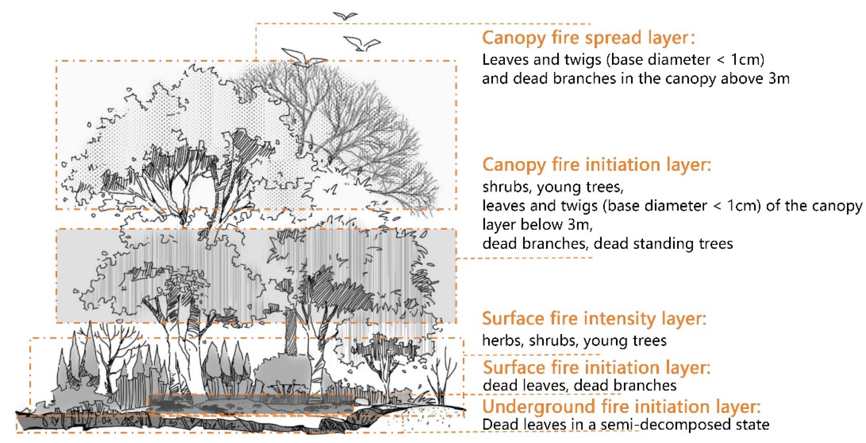
3.3. Research on Fire Behavior of Urban Vegetation Fires

The classification and attributes of fire behavior have consistently been at the forefront of fire research. Governed by the conditions of combustibles, the fire environment, and ignition sources, the rules of variation are exceedingly intricate [68]. Initial research in this domain commenced with forest fires, concentrating primarily on surface and canopy fires [69]. Surface fires, which involve the combustion of materials on the forest floor, constitute approximately 94% of all forest fires, making them the most prevalent type [70]. The incidence of crown fires is predominantly influenced by the structure and spatial arrangement of tree canopies. The rate of spread is intricately linked to wind velocity, fuel height, and load [71]. Nonetheless, when localized surface fires encounter robust winds, the flames are prone to ignite the canopy, escalating into crown fires, which are noted for their intense heat and rapid spread, susceptible to extreme behaviors that can lead to catastrophic outcomes [72,73].
The characteristics of fire behavior are dictated by the type of fuel involved [42]. Variability in site conditions, tree species composition, and modes of human disturbance led to differences in fuel levels, composition, and structure, which in turn directly influence the traits of fire behavior. Notably, the combustible frequently serves as the initial fire source. Existing research has categorized plant combustibles into five distinct levels (Figure 4), providing a nuanced representation of the fire spread process within plant communities [74].
WUI fires are defined as those occurring within the intermixed zones of urban structures and greenery, or the areas where buildings and vegetation are in close proximity [2]. Gaining a comprehensive understanding of WUI fire spread mechanisms is instrumental in further comprehending the unique challenges of urban vegetation fires. Within urban environments, fire propagation is accelerated, and the extent of fire spread is primarily facilitated through the interplay of thermal radiation, convection currents, and airborne embers [75]. Thermal radiation is a predominant factor with a high potential to initiate the ignition of structures [76]. This is where the concept of home ignition zone emerged. Building upon this foundation, Weng Tao et al. [77] developed a multi-tree thermal radiation model to assess the impact of canopy fires on the thermal radiation of buildings, thereby preliminarily delineating the characteristic fire propagation mechanisms specific to WUI areas. This research contributes to the body of knowledge on urban fire dynamics and the development of strategies for mitigating the risks associated with WUI fires.
Urban greening, serving as a conduit between artificial and natural environments, exhibits greater diversity in tree species selection compared to forests and the site environment that is more variable than the WUI, with a unique fire propagation mechanism. Currently, research on the fire behavior of urban green spaces is limited, with a predominant focus on how alterations in plant spatial patterns affect fire resistance. By selecting and distributing landscape plants, as well as optimizing and adjusting community structures, the fire prevention capabilities of urban green spaces can be maximized, creating effective fire-resistant zones that offer safe havens for disaster avoidance and the protection of residents. For instance, the FPS planting model (Figure 5), proposed by Japanese scholars, is designed to mitigate fire spread risks in urban parks by understanding fire behavior [78].
Initially, the study of fire behavior primarily involved the collection of pertinent data through the construction of realistic scenes and the observation of combustion phenomena. Yet, alongside the swift advancement of computer technology, the employment of fire spread models to replicate or simulate actual fire scenarios has emerged as the predominant research methodology throughout the 20th century and beyond. Fire spread models involve mathematical manipulation under a range of simplified conditions, culminating in the derivation of quantitative relationships between fire behavior and a myriad of parameters, including the physical and chemical properties of fuels, meteorological factors, and topographic variables, among others. Utilizing these relationships, researchers can forecast potential fire behaviors or simulate existing ones [79,80]. To date, fire spread models are primarily categorized into physical models, semi-physical models, empirical models, and semi-empirical models. Notably, empirical and semi-empirical models are the most extensively utilized for predicting fire behavior, including notable examples such as the Rothermel model, Canadian Forest Fire Behavior Prediction (CFBP) system, the McArthur-based Australian grassland fire hazard scale, and Wang Zhengfei’s model [81,82,83].
Currently, the majority of fire spread models and simulation software in widespread use are developed and expanded based on the Rothermel model [80].
In 1972, Rothermel proposed the following fire spread model. Below is the complete formulation of the model, along with detailed explanations of its parameters, as follows:
R = I R ξ 1 + Φ w + Φ s ρ b ε Q i g  
where
  • R is the fire spread rate, measured in m/s;
  • I R is the fire reaction intensity, expressed in W/m2;
  • ξ is a coefficient related to heat transfer;
  • Φ w and Φ s are the coefficients representing the effects of wind and terrain slope, respectively;
  • ρ b is the bulk density of the fuel complex after drying, measured in kg/m3;
  • ε is a heating coefficient associated with bulk density;
  • Q i g is the heat required to ignite a unit weight of fuel.
I R = ρ b × H c × v f  
where
  • H c is the heat of combustion of the fuel, expressed in J/kg;
  • v f is the velocity factor of the combustion front.
ξ = ρ b × c p × d e H c  
where
  • c p is the specific heat capacity of the fuel, J/(kg·K);
  • d e is the equivalent diameter of the fuel particles, expressed in m.
Φ w = 1 + C w × U u 0  
where
  • C w is the wind sensitivity coefficient;
  • U is the wind speed, measured in m/s;
  • u 0 is the reference wind speed, measured in m/s.
Φ s = 1 + C s × sin θ  
where
  • C s is the slope sensitivity coefficient;
  • θ is the terrain slope angle.
Commonly used fire spread simulation models often incorporate Byram’s fire intensity formula. This formula provides a foundational framework for quantifying fire behavior and has been widely integrated into fire dynamics models to enhance predictive accuracy. In 1959, Byram proposed the fire intensity formula to calculate the energy released per unit length of the fireline per unit time. The formula is expressed as follows:
I = H W R  
where
  • I is the fireline intensity, measured in Btu/ft/s;
  • H is the heat content of the fuel, measured in Btu/lb;
  • W is the effective fuel load, measured in lb/ft2;
  • R is the rate of fire spread, measured in ft/s.
Table 4 presents the fire spread simulation models that were developed between 1980 and 2010 and have since been widely adopted in the field. The United States Forest Service developed the FARSITE Forest Fire Spread Engine, primarily utilized for simulations in complex environments. For instance, Zigner et al. [84] employed this model to simulate wildfires in fire-prone regions of the western United States, using different ignition methods under various wind conditions to predict the speed and extent of fire spread. The BEHAVE series forest fire behavior and fuel model, developed by the United States Department of Agriculture, is predominantly used for simulating surface fire behavior, providing substantial scientific and technological support for forest fire management in the United States. It encompasses complex phenomena, including the ignition, burning, and spread of mixed vegetation and structures. In the context of the wildland–urban interface (WUI), where the built environment significantly influences fire behavior, the National Institute of Standards and Technology (NIST) developed the Fire Dynamics Simulator (FDS). Originally designed to model fire development within and between buildings, FDS has been expanded through the development of additional modules to simulate fire spread in urban–wildland interface areas. This advancement enables more comprehensive fire scenario analyses, integrating both urban and natural landscape factors. Overall, in practical applications, the FARSITE model holds significant value for forest fire prevention and firefighting command; the BEHAVE model is more suited for fire prevention planning and the formulation of fire emergency plans. For fire cause analysis and building fire protection design, FDS offers detailed information on fire processes.
As computer technology continues to advance and innovate, the simulation environment for fire spread, which integrates scientific rigor with intuitive interfaces, is progressively reaching maturity [85,86]. For instance, Pirk et al. [87] simulated the interaction with flames by altering the physicochemical properties of plants, thereby simulating the actual phenomenon of plant combustion. Wahlqvist et al. [88] innovatively developed the WUI-Nity tool utilizing the Unity3D game engine to simulate and visualize human behavior and wildfire propagation during the evacuation of WUI communities. Leveraging VIIRS fire monitoring data, Xu et al. [89] initialized the FARSITE fire simulation system to recreate forest fire scenarios in Inner Mongolia, China. This demonstrates that the multidimensional visualization of fire spread offers a more realistic and detailed predictive simulation of fire ground conditions and is poised to become a significant area of focus in future fire prevention and disaster mitigation efforts.
FIRETEC, developed by the Los Alamos National Laboratory in New Mexico, USA, is a multiphase transport wildfire model based on the principles of mass, momentum, and energy conservation. This model simplifies the complex reactions of wildfire combustion into the following four modes: pyrolysis, char combustion, hydrocarbon combustion, and aerobic soot combustion. WFDS, developed by the National Institute of Standards and Technology (NIST) in the USA, is a three-dimensional physical mechanism model based on fluid dynamics and combustion control equations, incorporating approximations of the thermal degradation of combustibles. Both models are suitable for studying small-scale wildfires over short timeframes but lack predictive capabilities for wildfire behavior. Compared to the aforementioned general-purpose models, their applicability is relatively limited.
Relevant studies have demonstrated that coupling mesoscale weather models with fire spread models can capture some critical wildfire behaviors. This paper focuses on reviewing and analyzing these coupled models, which represent the mutual feedback mechanisms between fire behavior and atmospheric conditions, based on their coupling mechanisms.
The CAWFE (Coupled Atmosphere-Wildland Fire Environment) model, developed by the U.S. National Center for Atmospheric Research (NCAR), was the first attempt to couple an atmospheric model with a wildfire model. It integrates the mesoscale atmospheric model Clark–Hall with a forward-tracking-based fire spread module. The fire spread module employs the semi-physical approach proposed by Rothermel, enabling the simulation of fire behavior under various meteorological conditions, such as scenarios where wind is primarily driven by terrain-induced thermal heterogeneity, fires influenced by severe drought, or those affected by extreme winds.
The WRF-FIRE (SFIRE) model integrates atmospheric simulation, data assimilation, and numerical weather prediction into a unified framework, significantly improving mesoscale weather simulations and forecasts. It has been widely applied in regional weather simulations and operational forecasting. The FIRE (SFIRE) module within WRF serves as an additional physical option and draws inspiration from the CAWFE model. It is a two-dimensional model designed specifically for surface fires, such as those occurring in grasslands, shrublands, or areas with fallen leaves and branches, but it does not account for crown fires. The fireline spread rate in this module also adopts the semi-physical method proposed by Rothermel. Using this coupled approach, Coen simulated a forest fire in Colorado in 2002, revealing how wildfires alter local wind fields and the shape of burned areas. Subsequently, Peace et al. conducted simulations of two forest fires in Australia in 2007 and 2010, demonstrating that wildfires significantly modify their surrounding atmospheric environment during propagation. These findings highlight the limitations of using constant meteorological inputs for wildfire spread simulations.
The ARPS/DEVS-FIRE model, developed by the French National Meteorological Research Center and the Laboratory of Climatology, is a mesoscale model capable of simulating phenomena at scales ranging from microscale (10 m) to meso-gamma scale (1 km). Filippi et al. conducted extensive research using this coupled method, validating the effectiveness of the model. Compared to uncoupled simulations, the coupled simulations showed a notable increase in fireline spread rates, indicating the significant impact of locally induced winds by wildfires on ambient wind conditions. In one experiment, different terrain conditions (e.g., valley bottoms, valleys, and ridges) were set up to investigate the effects of coupling on wind fields under varying topographies.
In summary, coupled models generally integrate large-scale weather models with small-scale wildfire models. Their primary mechanism involves the mutual feedback between relevant parameters of the weather and fire models at each discrete time step of the weather model, followed by iterative integration calculations. This process continuously cycles at each time step to simulate the interaction between the atmosphere and wildfires. Existing studies indicate that coupled models provide more realistic wildfire spread simulations compared to uncoupled models, particularly for large-scale wildfire events. Additionally, due to design and computational algorithm requirements, the WRF-FIRE (SFIRE) model is currently capable of real-time forecasting, while other models are better suited for reconstructing wildfire processes.
From the current state of wildfire modeling research, it is evident that developing an ideal wildfire spread model remains challenging, as it requires comprehensively considering factors such as fuel characteristics, meteorological conditions, and topography. These factors exhibit diversity and uncertainty depending on geographical location. Therefore, integrating the ecological realities and site-specific conditions of study areas to obtain more comprehensive and accurate parameter information, and constructing fire spread models tailored to different environments will be a key direction for future research in this field.

3.4. Fire Risk Assessment and Prediction

Fire risk is typically conceptualized as an amalgamation of quantitative assessments of fire likelihood and potential outcomes. Evaluations and predictions of fire risk primarily hinge on the likelihood of fire occurrence and spread, as well as the magnitude of potential consequences. Over the past three decades, a multitude of studies have synthesized methods for assessing and predicting fire risk across forests, urban areas, and WUI, employing diverse perspectives and analytical techniques [90,91,92]. Urban green spaces, integral components of the urban ecosystem, offer residents ideal venues for leisure, entertainment, and cultural engagement, while also serving as pivotal elements in enhancing urban esthetics and quality [93]. Nevertheless, current research on the fire risk within urban green spaces remains inadequate, often subsumed within broader assessments of urban, forest, or WUI contexts, and lacking a dedicated and systematic research framework.
Fire risk assessment, foundational to fire risk prediction, serves as a critical premise for scientific fire management. Typically, fire risk assessments are grounded in historical data, environmental conditions, building characteristics, population density, and other relevant information, focusing on the likelihood of fire occurrence, potential losses, and the extent of the impact [94,95,96]. The scope of research is categorized into urban, WUI, forest, and wilderness settings.
Urban fire risk assessments are typically integrated into regional fire risk evaluations and are categorized into three distinct approaches as follows: qualitative, semi-quantitative, and quantitative [97]. Qualitative assessments primarily depend on observational, analytical, and judgmental human expertise to ascertain the level of fire risk, typically eschewing specific numerical computations. For instance, the compilation of a safety inspection checklist for a designated area involves the assessor conducting an on-site evaluation, evaluating each item on the checklist individually, and ascertaining any issues or deviations from the prescribed standards. Ultimately, the area is classified and described as high risk, medium risk, or low risk. A semi-quantitative assessment integrates qualitative and quantitative methodologies to ascertain the relative magnitude of fire risk, though the outcome is generally not a precise numerical figure. Quantitative assessments involve the establishment of a mathematical model, utilizing specific data to compute an accurate quantification of the fire risk.
This study categorizes risk assessment methods into the following two primary techniques: traditional, indicator-based assessments; and modern, machine learning-based assessments [98]. The aim of the traditional, indicator-based evaluation method is to develop a comprehensive assessment system to accurately gauge regional fire risk levels. This traditional approach generally involves three steps as follows: establishing a regional fire index system, ascertaining the indices’ weights, and assessing regional fire risk levels (Figure S1). Modern machine learning-based assessment methods typically encompass the following four steps: identifying regional fire risk factors, acquiring and preprocessing factor data, training and optimizing the chosen model, validating the model, and evaluating and predicting outcomes (Figure S2). This enables large-scale analysis, assessment, and prediction of urban fire risk issues.
In the realm of regional fire risk assessment, both traditional indicator-based evaluations and modern machine learning-based evaluations possess distinct advantages. Currently, the utilization of machine learning for urban fire risk assessment, in comparison to traditional indicator-based methods, remains relatively limited. However, as urban environments continually evolve and generate substantial data, this presents opportunities for leveraging machine learning in regional fire risk assessments. Considering the unique attributes of each method, machine learning can complement traditional assessments in regions with sufficient data and heightened fire risks. In other regions, traditional assessment methods may continue to serve regional fire risk evaluations. Nevertheless, with advancements in data processing capabilities, model training velocities, and hardware conditions, machine learning is poised to become the predominant approach for regional fire risk assessments [37].
Fire risk prediction leverages existing data and models to assess the likelihood of future fire occurrences, typically utilizing real-time monitoring data, meteorological conditions, environmental variables, and other dynamically updated information, focusing on the probability and trends of future fire occurrences [99]. This field has emerged as a prominent research focus globally. Historically, the majority of pertinent models relied on probability and statistical methods. As big data and artificial intelligence continue to evolve, machine learning-based fire risk prediction methods are poised to become the mainstream. Current research encompasses advanced algorithms, including Back Propagation (BP), Support Vector Machines (SVM), Random Forest (RF), and deep learning models, which have demonstrated superior performance compared to traditional methods [100]. For instance, You et al. [101] integrated the Particle Swarm Optimization (PSO) algorithm with a traditional Convolutional Neural Network (CNN) to develop the PSO-CNN model. This model was successfully applied to nationwide forest fire risk prediction in China, with results that closely aligned with the actual distribution of fire data.
Given the influence of diverse factors such as meteorological conditions, terrain, and human activities on fire risk prediction, it remains challenging to develop a universal model that addresses all prediction issues. However, in recent years, there has been a progressive development of models tailored to China’s distinct meteorological conditions, geographic environments, and fuel properties, thereby enabling more precise predictions of fire behavior. For instance, Huang et al. [102] forecasted the future probabilities and extents of forest fires in northern China through the integration of the Linkage Forest ecosystem model, LANDIS PRO forest landscape model, and SPP spatial point pattern model. Miao et al. [103] utilized a Transformer model framework and incorporated a Window mechanism to devise a Window-based Transformer model for forest fire prediction, generating a forest fire sensitivity zoning map for the Chongli region in northern China. Li et al. [104] introduced a Stacking Ensemble Learning model, combining Random Forest (RF), eXtreme Gradient Boosting (XGBoost), Light Gradient Boosting Machine (LightGBM), and Multilayer Perceptron (MLP), to forecast forest fire risk in Yunnan Province, southern China, by integrating diverse data including meteorological, topographical, vegetation, and human activity data.
By integrating traditional models with widely used machine-learning models, the primary factors influencing fire risk assessment and prediction can be categorized into four major aspects as follows: fuel, topography, meteorology, and human activities. Among these, fuel and topography are relatively stable fire risk factors, as they tend to remain unchanged over short periods in the absence of external interference. Fuel factors are typically most closely related to vegetation composition, including fuel type, vegetation moisture content, humus layer humidity, and normalized vegetation index. In the context of urban vegetation fires, these factors are particularly associated with the dominant plant species and the spatial structure of plant communities. Topographic factors include the slope gradient, aspect, and elevation. Meteorological factors, on the other hand, are the most dynamic and influential in determining fire risk. These primarily consist of air temperature, relative humidity, wind speed, and precipitation. Meteorological factors not only interact with each other but also exhibit complex interdependencies, making them the most intricate component in fire risk assessment. Among these factors, wind plays a critical role in fire behavior. Most destructive fires are wind driven. For instance, dynamic changes in wind direction and speed can cause fire behavior to shift from surface fire to crown fire [105]. Human activities represent the main ignition sources for fires in forests, urban areas, and WUI zones. These activities are often quantified by metrics such as the proximity to road networks, distance from residential areas, and population density. Generally, areas with higher levels of human activity are more prone to fire occurrences.

4. Discussion

Climate change, a global challenge, exerts profound impacts on natural ecosystems and human societies. In urban settings, climate change significantly affects the occurrence of vegetation fires, altering not only the likelihood of fires but also their intensity and rate of spread [106]. The rise in global temperatures, a hallmark of climate change, directly leads to the increased dryness of urban vegetation. As temperatures rise, the evaporation of water from soil and plants accelerates, making ignition more likely. Secondly, alterations in precipitation patterns are a common consequence of climate change, leading to more severe droughts in some regions [107]. Climate change can disrupt seasonal patterns, affecting the growth cycle of vegetation and, in turn, the length of the fire season [1]. Additionally, shifts in wind patterns, including speed and direction, are pivotal, as strong winds can rapidly spread fires over larger areas [108].
Urban greening is pivotal in mitigating climate change and reducing fire risks. By lowering temperatures, increasing humidity, improving microclimates, serving as fire barriers, raising public awareness, reducing combustible materials, providing biodiversity, acting as carbon sinks, planning and designing, managing disasters, and enhancing quality of life, urban greening is an essential strategy for cities to address fire and climate change risks [93]. Conversely, the inappropriate selection of vegetation in high fire-risk areas may exacerbate fire spread and intensity. For instance, the extensive planting of palm trees in the WUI regions of California, USA, has been identified as a factor that can contribute to the rapid expansion and intensification of wildfires.
However, the implementation of urban greening encounters various challenges. Urban development pressures, land use changes, and escalating maintenance costs can all affect greening effectiveness [109]. Thus, a comprehensive urban greening strategy is essential to ensure effective implementation and alignment with long-term urban planning and objectives. Ongoing attention is required for the management and maintenance of urban green spaces. The inadequacy of urban greening applications underscores a theoretical deficit within the associated research. This shortfall is primarily evident in three pivotal areas as follows:

4.1. Inadequate Integration of Fire-Resistant Landscape Plants

The impact of climate change on fire behavior and the selection of appropriate plant species for fire resistance is not sufficiently addressed, leading to potential vulnerabilities in urban landscapes.
Firstly, research and attention regarding the fire resistance of landscape plants are limited, and a systematic framework for assessing their fire resistance is notably absent. While remarkable progress has been made in researching fire-resistant tree species for forestry, the distinct urban environments and varied attributes of landscape plants pose limitations on their applicability in urban greening, presenting new challenges in enhancing their fire prevention capabilities. Furthermore, the evaluation metrics used in existing studies lack standardization, often focusing on a single aspect, which results in limited, inconsistent, and even contradictory conclusions [53,110].
Ultimately, there is a need to explore the role of urban greening in adapting to climate change by enhancing their fire-resistant properties. This could involve studying the physiological adaptations of plants to higher temperatures, prolonged droughts, and altered precipitation patterns, which are all factors that can influence the likelihood and intensity of fires [106]. By understanding these dynamics, urban greening strategies can be tailored to create landscapes that are more resilient to the impacts of climate change, including fire risks.

4.2. Lack of Comprehensive Models

Urban greening fires exhibit distinct complexities and specificities compared to forest and structural fires. Urban greening fires can be categorized into fires originating from landscape plants and those spreading from external sources. Consequently, the physical mechanisms for controlling fire spread in these scenarios differ significantly from those applicable to forests and buildings.
Current research often lacks holistic models that integrate the multifaceted aspects of urban environments, including the interactions among different plant species, the urban fabric, and human activities [111]. The absence of such models limits the ability to predict and manage fire risks effectively. In future studies, a variety of urban greening types should be explored as research subjects, based on the identification of fire-resistant landscape plants, to uncover the fire behavior traits of green spaces and to develop corresponding systematic control measures and enhancement strategies. This approach will help address the unique challenges posed by urban greening fires and contribute to the development of more effective fire prevention and management practices in urban landscaping.

4.3. Neglect of the Multifunction of Urban Greening

At its core, the versatile role of urban greening renders it a critical component in cities’ strategies to combat climate change and fire risks. By opting for vegetation that is resistant to fire, improving the capacity to absorb CO2, strategically designing the layout of green spaces, and strengthening disaster management through green initiatives, urban areas can enhance their resilience and develop safer, more sustainable environments that are well-prepared for future challenges. To boost fire prevention capabilities, urban greening must integrate a range of services, such as ecological benefits, esthetic enhancements, and social services. In formulating plans for fire-resistant urban greening, it is crucial to consider the unique characteristics of each site and the human activities in the region, and to develop urban management approaches that maintain fire safety while being attuned to local circumstances [93].
For future studies, it is essential to harness the distinctive features of landscaping and align those with urban planning, safety science, engineering, and forest conservation, promoting interdisciplinary cooperation. This collaborative approach will encourage cross-professional partnerships to advance the multifunctional and coordinated development of urban habitats.

5. Conclusions

Climate change is causing an increase in extreme weather events globally, such as heatwaves, droughts, and strong winds, which significantly elevate urban fire risks [2,7]. This poses a severe threat to urban ecological security. Consequently, developing fire-preventive urban green spaces has become a crucial strategy. However, current efforts in fire prevention and disaster mitigation within urban greening are insufficient.
In this study, CiteSpace software was used to systematically summarize key research topics in urban greenery and fire management. A selection of highly cited and relevant studies was analyzed in depth. This study explores methods for evaluating the fire-preventive capabilities of landscape plants, fire behavior in urban vegetation, and fire risk assessment and prediction mechanisms. The discussion is structured across micro, meso, and macro scales, identifying research gaps and proposing future directions.
Firstly, the evaluation of fire-resistant properties in landscape plants primarily relies on laboratory-based methods. Combustion experiments measure ignition points and heat values using calorimetry to assess plant flammability, categorizing characteristics into inflammability, combustibility, sustainability, and consumability. Thermogravimetric analysis constructs kinetic models to rank thermal stability and reveal pyrolysis reactions. Physicochemical experiments investigate intrinsic fire-resistant mechanisms, with moisture content being a critical metric. Functional traits are essential for selecting fire-resistant species. However, the current research is insufficient, focusing mainly on forest ecosystems and lacking a comprehensive evaluation framework for urban landscape plants. Future work should develop an integrated selection mechanism for urban landscape plants, considering urban complexities and climate change.
Secondly, fire behavior is influenced by fuel characteristics, fire environment, and ignition sources, resulting in complex dynamics. Surface and crown fires are key research areas. Fire behavior types are determined by fuel properties, which vary with site conditions. If plants possess good fire-resistant properties and are combined with scientifically designed spatial structures, they can effectively block heat radiation and inhibit flame propagation. Current fire spread models are mostly empirical or semi-empirical, primarily for forest and WUI regions. Our understanding of fire behavior in urban vegetation is insufficient, lacking simulation models. Future research should focus on urban vegetation fires, leveraging emerging technologies to enhance predictive capabilities and mitigation strategies.
Thirdly, fire risk is a quantitative combination of fire probability and the potential consequences. Traditional methods such as probability theory and statistics have been used, but machine learning and deep learning are now primary tools for constructing predictive models. These techniques improve prediction accuracy and provide more precise estimations of fire locations and extents. Urban vegetation fires exhibit unique characteristics due to variations in the microclimate and site conditions. Future research should integrate modern technologies with traditional index systems to develop robust frameworks for assessing and predicting urban vegetation fire risks, supporting effective mitigation strategies.
In summary, the development of green urban fire protection presents a multifaceted challenge and serves as a critical component in addressing the fire risks posed by climate change. By conducting thorough research on the selection mechanisms of fire-resistant landscape plants and optimizing the arrangement of landscape plant communities, while also taking into account the diverse service functions of urban greening, a scientifically sound and efficient system for fire prevention in urban green spaces can be progressively developed. This will provide robust support for the sustainable development and ecological safety of future urban environments.

Supplementary Materials

The following supporting information can be downloaded at: https://www.mdpi.com/article/10.3390/su17062680/s1, Figure S1: Traditional evaluation method based on indicators and its common methods; Figure S2: Modern evaluation method based on machine learning and its common models.

Funding

This research was funded by [The National Natural Science Foundation of China] grant number [32071824], [2024 Graduate Textbook Construction Project of Tongji University] grant number [2024JC07] and [2024 Central University Fundamental Research Funds of Tongji University] grant number [22120240668].

Data Availability Statement

Data available in a publicly accessible repository.

Conflicts of Interest

The authors declare no conflict of interest.

References

  1. Hantson, S.; Hamilton, D.S.; Burton, C. Changing fire regimes: Ecosystem impacts in a shifting climate. One Earth 2024, 7, 942–945. [Google Scholar] [CrossRef]
  2. Manzello, S.L.; Suzuki, S. The importance of combustion science to unravel complex processes for informal settlement fires, urban fires, and wildland-urban interface (WUI) fires. Fuel 2022, 314, 122805. [Google Scholar] [CrossRef]
  3. Lenihan, J.M.; Bachelet, D.; Drapek, R.J.; Neilson, R.P. Skillful forecasting of global fire activity using seasonal climate predictions. Nat. Commun. 2018, 9, 2718. [Google Scholar]
  4. Zhang, W.; Shen, R. Review of urban fire risk cognition and its logical limitations and countermeasures. Syst. Eng. Theory Pract. 2019, 39, 387–396. [Google Scholar]
  5. Ryu, S.-R.; Choi, H.-T.; Lim, J.-H.; Lee, I.-K.; Ahn, Y.-S. Post-fire restoration plan for sustainable forest management in South Korea. Forests 2017, 8, 188. [Google Scholar] [CrossRef]
  6. Geovana, P.A.; Josiane, D.V.; Valter, E.B.; Marcelo, A.M.; Bruna, A.S.; Juliano, Z.G.; Benjamin, S.L. Exploratory analysis of fire statistical data and prospective study applied to security and protection systems. Int. J. Disaster Risk Reduct. 2021, 61, 102308. [Google Scholar]
  7. Harvey, B.J. Human-caused climate change is now a key driver of forest fire activity in the western United States. Proc. Natl. Acad. Sci. USA 2016, 113, 11649–11650. [Google Scholar] [CrossRef]
  8. Li, X.; Li, L.; Lin, M.; Jim, C.Y. Research on Risk and Resilience Evaluation of Urban Underground Public Space. Int. J. Environ. Res. Public Health 2022, 19, 15897. [Google Scholar] [CrossRef]
  9. Li, H.; Zhang, D. Research status and prospect of fire resistance of green plants. Chin. Urban For. 2022, 20, 133–139. [Google Scholar]
  10. Huang, C.; Feng, J.; Tang, F.; He, H.; Liang, Y.; Wu, M.; Xu, W.; Liu, B.; Shi, F.; Chen, F. Predicting the responses of boreal forests to climate-fire-vegetation interactions in Northeast China. Environ. Model. Softw. 2022, 153, 105410. [Google Scholar] [CrossRef]
  11. Zhang, D.; Chen, J.; Wu, X.; Li, K.; Zhang, B.; Yao, C. Correlation between morphological characteristics and fire resistance of landscape trees. Chin. Urban For. 2019, 18, 23–28. [Google Scholar]
  12. Yao, M.; Zhang, D.; Zhu, R.; Zhang, Z.; Elsadek, M. Predicting the Integrated Fire Resistance of Wildland–Urban Interface Plant Communities by Spatial Structure Analysis Learning for Shanghai, China. Forests 2024, 15, 1266. [Google Scholar] [CrossRef]
  13. Parks, S.A.; Abatzoglou, J.T. Warmer and Drier Fire Seasons Contribute to Increases in Area Burned at High Severity in Western US Forests From 1985 to 2017. Geophys. Res. Lett. 2020, 47, e2020GL089858. [Google Scholar] [CrossRef]
  14. Ren, J.; Hanan, E.J.; Abatzoglou, J.T.; Kolden, C.A.; Tague, C.L.; Kennedy, M.C.; Liu, M.; Adam, J.C. Projecting Future Fire Regimes in a Semiarid Watershed of the Inland Northwestern United States: Interactions Among Climate Change, Vegetation Productivity, and Fuel Dynamics. Earth’s Future 2022, 10, e2021EF002518. [Google Scholar] [CrossRef]
  15. Jennings, C.R. Socioeconomic Characteristics and Their Relationship to Fire Incidence: A Review of the Literature. Fire Technol. 1999, 35, 7–34. [Google Scholar] [CrossRef]
  16. Tian, X.; Shu, L.; Qiao, Q.; He, Q.; Li, H. Research on the screening of fireproof tree species in Southern Forest area. J. Beijing For. Univ. 2001, 23, 43–47. [Google Scholar]
  17. Vedal, S.; Dutton, S.J. Wildfire air pollution and daily mortality in a large urban area. Environ. Res. 2006, 102, 29–35. [Google Scholar] [CrossRef]
  18. Jun, W.; Arthur, M.W.; Ralph, J.D. Exposure assessment of particulate matter air pollution before, during, and after the 2003 Southern California wildfires. Atmos. Environ. 2006, 40, 3333–3348. [Google Scholar]
  19. Neary, D.G.; Overby, S.T. Wildfire and post-fire erosion impacts on forest ecosystem carbon and nitrogen: An analysis. For. Ecol. Manag. 2006, 234, S162. [Google Scholar] [CrossRef]
  20. Abaffy, L. Using machine learning to cut fire risk from power grids. Eng. News-Rec. 2018, 281, 55. [Google Scholar]
  21. Agarwal, P.; Tang, J.; Narayanan AN, L.; Jun, Z. Big Data and Predictive Analytics in Fire Risk Using Weather Data. Risk Anal. 2020, 40, 1438–1449. [Google Scholar] [CrossRef]
  22. Burton, E.D.; Girish, C.; Chamindra, L.V.; Niloofar, K.; Kerstin, H.; Scott, G.J. Chromium (VI) formation via heating of Cr (III)-Fe (III)-(oxy)hydroxides: A pathway for fire-induced soil pollution. Chemosphere 2019, 222, 440–444. [Google Scholar] [CrossRef]
  23. Chen, L.; Dou, Q.; Zhang, Z.; Shen, Z. Moisture content variations in soil and plant of post-fire regenerating forests in central Yunnan Plateau, Southwest China. J. Geogr. 2019, 29, 1179–1192. [Google Scholar] [CrossRef]
  24. Msweli, S.T.; Potts, A.J.; Fritz, H.; Kraaij, T. Fire weather effects on flammability of indigenous and invasive alien plants in coastal fynbos and thicket shrublands (Cape Floristic Region). PeerJ 2020, 8, e10161. [Google Scholar] [CrossRef] [PubMed]
  25. Kraaij, T.; Msweli, S.T.; Potts, A.J. Flammability of native and invasive alien plants common to the Cape Floristic Region and beyond: Fire risk in the wildland–urban interface. Trees For. People 2024, 15, 100513. [Google Scholar] [CrossRef]
  26. Ocampo-Zuleta, K.; Pausas, J.G.; Paula, S. FLAMITS: A global database of plant flammability traits. Glob. Ecol. Biogeogr. 2024, 33, 412–425. [Google Scholar] [CrossRef]
  27. Yao, Q.; Jiang, D.; Zheng, B.; Wang, X.; Zhu, X.; Fang, K.; Shi, L.; Wang, Z.; Wang, Y.; Zhong, L.; et al. Anthropogenic warming is a key climate indicator of rising urban fire activity in China. Natl. Sci. Rev. 2024, 11, nwae163. [Google Scholar] [CrossRef] [PubMed]
  28. Li, X.; Wang, Q.; Zhang, Y. Study on the Combustibility of 15 Woody Plant Species in the Fire-prone Areas of Central Yunnan. For. Inventory Plan. 2016, 41, 62–68. [Google Scholar]
  29. Bär, A.; Michaletz, S.T.; Mayr, S. Fire effects on tree physiology. New Phytol. 2019, 223, 1728–1741. [Google Scholar] [CrossRef]
  30. Cui, X.; Dai, D.; Huang, C.; Wang, B.; Li, S.; You, C.; Paterson, A.M.; Perry, G.L.; Buckley, H.L.; Cubino, J.P.; et al. Climatic conditions affect shoot flammability by influencing flammability-related functional traits in non-fire-prone habitats. New Phytol. 2023, 240, 105–113. [Google Scholar] [CrossRef]
  31. Moinuddin KA, M.; Sutherland, D. Modelling of tree fires and fires transitioning from the forest floor to the canopy with a physics-based model. Math. Comput. Simul. (MATCOM) 2020, 175, 81–95. [Google Scholar] [CrossRef]
  32. Bufacchi, P.; Krieger, G.C.; Mell, W.; Alvarado, E.; Santos, J.C.; Carvalho, J.A. Numerical simulation of surface forest fire in Brazilian Amazon. Fire Saf. J. 2016, 79, 44–56. [Google Scholar] [CrossRef]
  33. Kreye, J.K.; Varner, J.M.; Hamby, G.W.; Kane, J.M. Mesophytic litter dampens flammability in fire-excluded pyrophytic oak–hickory woodlands. Ecosphere 2018, 9, e02078. [Google Scholar] [CrossRef]
  34. Dehane, B.; Hernando, C.; Guijarro, M.; Madrigal, J. Flammability of some companion species in cork oak (Quercus suber L.) forests. Ann. For. Sci. 2017, 74, 60. [Google Scholar] [CrossRef]
  35. Bryner, N.P.; Pellegrino, J.L.; Johnsson, E.L. Wildland-Urban Interface Fire Research Needs: Summary Report; NIST, SP 1150; National Institute of Standards and Technology: Gaithersburg, MD, USA, 2013. [Google Scholar]
  36. Price, O.; Bradstock, R. Countervailing effects of urbanization and vegetation extent on fire frequency on the Wildland Urban Interface: Disentangling fuel and ignition effects. Landsc. Urban Plan. 2014, 130, 81–88. [Google Scholar] [CrossRef]
  37. Hysa, A. Indexing the vegetated surfaces within WUI by their wildfire ignition and spreading capacity, a comparative case from developing metropolitan areas. Int. J. Disaster Risk Reduct. 2021, 63, 102434. [Google Scholar] [CrossRef]
  38. Nassauer, J.I. Messy ecosystems, orderly frames. Landsc. J. 1995, 14, 161–170. [Google Scholar] [CrossRef]
  39. Xiao, H.; Liu, X.; Zeng, S. Current situation and prospect of forest fire research in Europe and America. J. Northwest For. Coll. 2012, 27, 131–136. [Google Scholar]
  40. Cui, X.; Alam, M.A.; Perry, G.L.; Paterson, A.M.; Wyse, S.V.; Curran, T. Green firebreaks as a management tool for wildfires: Lessons from China. J. Environ. Manag. 2019, 233, 329–336. [Google Scholar] [CrossRef]
  41. Wen, D. Discussion on some problems about fire protection forest belt. For. Fire Prev. 1992, 4, 22–23+33. [Google Scholar]
  42. Chen, C.; Yang, C.; Wu, D. Research on Biological Fire Prevention; Northeast Forestry University Press: Harbin, China, 1995; pp. 1–3. [Google Scholar]
  43. Martin, R.E.; Gordon, D.A.; Gutierrez, M.A.; Lee, D.S. Assessing the flammability of domestic and wildland vegetation. In Proceedings of the 12th Conference on Fire and Forest Meteorology, Jekyll Island, GA, USA, 26–28 October 1993; pp. 130–137. [Google Scholar]
  44. Song, L.; Wang, Z.; Liu, Y.; Gao, J.; Li, B. Evaluation of burning characteristics and fire resistance of common shrubs in Beijing. Chin. J. Ecol. 2019, 42, 1056–1064. [Google Scholar]
  45. Cordero, T.; Rodríguez-Maroto, J.M.; Rodríguez-Mirasol, J. On the kinetics of thermal decomposition of wood and wood components. Thermochim. Acta 1990, 164, 135–144. [Google Scholar] [CrossRef]
  46. Fujioka, F.M.; Weise, D.R.; Chen, S.C.; Kim, S.H.; Kafatos, M.C. Reaction intensity partitioning: A new perspective of the National Fire Danger Rating System Energy Release Component. Int. J. Wildland Fire 2021, 20, 351–364. [Google Scholar] [CrossRef]
  47. Wang, L.; Xu, J.; Zhen, Y.; Zhang, H. Pyrolysis kinetics of main landscape tree species in Hohhot based on thermogravimetric analysis. J. Beijing For. Univ. 2020, 42, 87–95. [Google Scholar]
  48. Van Wilgen, B.W.; Higgins, K.B.; Bellstedt, D.U. The role of vegetation structure and fuel chemistry in excluding fire from forest patches in the fire-prone fynbos shrublands of South Africa. J. Ecol. 1990, 78, 210–222. [Google Scholar] [CrossRef]
  49. Zheng, H.N. Species of inflammable, inflammable, fireproof and fireproof trees. For. Fire Prev. 1991, 3, 32. [Google Scholar]
  50. Chen, F.; Si, L.; Zhao, F.; Wang, M. Volatile Oil in Pinus yunnanensis Potentially Contributes to Extreme Fire Behavior. Fire 2023, 6, 113. [Google Scholar] [CrossRef]
  51. Kane, J.M.; Kerhoulas, L.P.; Goff, G.S. Conifer encroachment increases foliar moisture content in a northwestern California oak woodland. Int. J. Wildland Fire 2023, 32, 728–737. [Google Scholar] [CrossRef]
  52. Wang, L.; Xu, J.; Zhu, P.; Li, J.; Zhang, H. Study on physicochemical properties and combustibility of main landscape tree species in Hohhot City. J. Nanjing For. Univ. (Nat. Sci. Ed.) 2019, 44, 74–80. [Google Scholar]
  53. Li, X.; Yang, X.; Yu, S.; Yan, E.; Zhang, J. Fire resistance evaluation of evergreen broad-leaved plants based on functional traits. Acta Ecol. Sin. 2013, 33, 6604–6613. [Google Scholar]
  54. Liu, X.; Wang, Q.; Liu, X. Study on the Fire Resistance Performance of 13 Evergreen Tree Species in Beijing Area. J. Chin. Urban For. 2019, 17, 6. [Google Scholar]
  55. Wei, R.; Yang, G.; Zhang, J.; Wang, X.; Zhou, X. The thermal insulation properties of oak (Quercus mongolica) bark and the applicability of stem heating models. Int. J. Wildland Fire 2019, 28, 969–980. [Google Scholar] [CrossRef]
  56. Saito, Y.; Iwakawa, N. A study on the fire prevention function of trees. J. Landsc. Archit. 1983, 46, 158–163. [Google Scholar]
  57. Toshinori, H.; Masahiko, S.; Sanae, M.; Kazue, F. An experimental study on the effect of reducing the amount of heat received by trees near flame in the background. J. Green Eng. 2012, 38, 33–38. [Google Scholar]
  58. Tian, X. Research on Fire Resistance Mechanism of Fireproof Forest Belt. Ph.D. Thesis, Beijing Forestry University, Beijing, China, 2000. [Google Scholar]
  59. Li, H. Study on Fire Resistance of Landscape Tree Species in Shanghai. Master’s Thesis, Tongji University, Shanghai, China, 2023. [Google Scholar]
  60. Rasooli, S.B.; Rashidi, S.; Shabanian, N. Fire sensitivity of broadleaf tree species in plantations of Kurdistan, Iran. For. Res. 2021, 32, 10. [Google Scholar] [CrossRef]
  61. Seo, H.; Choung, Y. Enhanced vulnerability to fire by Pinus densiflora forests due to tree morphology and stand structure in Korea. J. Plant Biol. 2014, 57, 48–54. [Google Scholar] [CrossRef]
  62. Bruna, K.; Igor, K.T.; Andressa, T.; Alexandre, F.T.; Antonio, C.B. Inflamabilidade de espécies arbóreas para uso em cortinas de segurança na prevenção de incêndios florestais. Braz. J. For. Res. 2016, 88, 387–391. [Google Scholar]
  63. Madrigal, J.; Hernando, C.; Guijarro, M.; Díez, C.; Marino, E.; De castro, A. Evaluation of forest fuel flammability and combustion properties with an adapted mass loss calorimeter device. J. Fire Sci. 2009, 27, 323–342. [Google Scholar] [CrossRef]
  64. Alessio, G.A.; Peñuelas, J.; Liusiàa, J.; Ogaya, R.; Estiarte, M.; De Lillis, M. Influence of water and terpenes on flammability in some dominant Mediterranean species. Int. J. Wildland Fire 2008, 17, 274–286. [Google Scholar] [CrossRef]
  65. Wyse, S.W.; Perry, G.L.W.; O’Connell, D.M.; Holland, P.S.; Wright, M.J.; Hosted, C.L.; Whitelock, S.L.; Geary, I.J.; Maurin, K.J.L.; Curran, T.J. A quantitative assessment of shoot flammability for 60 tree and shrub species supports rankings based on expert opinion. Int. J. Wildland Fire 2016, 25, 466–477. [Google Scholar] [CrossRef]
  66. Ghermandi, L.; Beletzky, N.A.; Curth MI, T.; Oddi, F.J. From leaves to landscape: A multiscale approach to assess fire hazard in wildland-urban interface areas. J. Environ. Manag. 2016, 183 Pt 3, 925–937. [Google Scholar] [CrossRef]
  67. Zhang, D.; Wu, X.; Chen, L.; Hu, L.; Li, K.; Zhan, Y.; Yao, C. Combustibility evaluation of 26 landscape tree species in shanghai. J. Tongji Univ. Nat. Sci. 2021, 49, 1399–1406. [Google Scholar]
  68. Niu, S. Study on Fire Behavior and Fuel Spatial Continuity of Main Forest Types in Beijing Mountain Area. Ph.D. Thesis, Beijing Forestry University, Beijing, China, 2011. [Google Scholar]
  69. Xie, X. Experimental and Theoretical Research on Slope Surface Fire Spread. Ph.D. Thesis, University of Science and Technology of China, Hefei, China, 2014. [Google Scholar]
  70. Varner, J.M.; Hood, S.M.; Aubrey, D.P.; Yedinak, K.; Rowell, E.M. Tree crown injury from wildland fires: Causes, measurement and ecological and physiological consequences. New Phytol. 2021, 231, 1676–1685. [Google Scholar] [CrossRef] [PubMed]
  71. Zong, X.; Tian, X. Research progress of forest fire behavior and control technology. World For. Res. 2019, 32, 31–36. [Google Scholar]
  72. Furlaud, J.M.; Williamson, G.J.; Bowman DM, J.S. Mechanical treatments and prescribed burning can reintroduce low-severity fire in southern Australian temperate sclerophyll forests. J. Environ. Manag. 2023, 344, 118301. [Google Scholar] [CrossRef]
  73. Wang, X. Research on Forest Burning in Beijing Mountain Area. Ph.D. Thesis, Beijing Forestry University, Beijing, China, 2010. [Google Scholar]
  74. Brad, M.; Leigh, M.; Colin, B.; Daniel, K.; Megan, P. Selecting low-flammability plants as green firebreaks within sustainable urban garden design. Fire 2018, 1, 15. [Google Scholar] [CrossRef]
  75. Wan, Y. Urban Disaster Prevention, 2nd ed.; China Building and Construction Press: Beijing, China, 2006. [Google Scholar]
  76. Weng, T. Research on Fire Behavior Model and Emergency Decision-Making at Urban Forest Boundary. Ph.D. Thesis, University of Science and Technology of China, Hefei, China, 2007. [Google Scholar]
  77. Ryan, K.C.; Reinhardt, E.D. Predicting postfire mortality of seven western conifers. Can. J. For. Res. 1988, 18, 1291–1297. [Google Scholar] [CrossRef]
  78. Li, S.; Li, Y.; Ren, B.; Xie, J. Fire-resistant function of landscape plants and plant arrangement of fireproof green space. Landsc. Archit. 2008, 6, 92–97. [Google Scholar]
  79. Carol, M.; Dean, L.U. A model of surface fire, climate and forest pattern in the Sierra Nevada, California. Ecol. Model. 1999, 114, 113–135. [Google Scholar]
  80. Rothermel, R.C. A Mathematical Model for Predicting Fire Spread in Wildland Fuels; USDA Forest Service Research Paper INT-115; Intermountain Forest & Range Experiment Station, Forest Service, US Department of Agriculture: Ogden, UT, USA, 1972. [Google Scholar]
  81. Noble, I.R.; Bary, G.A.; Gill, A.M. McArthur’s fire-danger meters expressed as equations. Aust. J. Ecol. 1980, 5, 201–203. [Google Scholar] [CrossRef]
  82. Wang, Z. Estimation method of initial spread velocity of mountain fire. Mt. Res. 1983, 1, 42–51. [Google Scholar]
  83. Aleander, M.E. Surface fire spread potential in trembling aspen during summer in the boreal forest region of Canada. For. Chron. 2010, 86, 200–212. [Google Scholar] [CrossRef]
  84. Zigner, K.; Carvalho, L.M.V.; Jones, C.; Benoit, J.; Duine, G.-J.; Roberts, D.; Fujioka, F.; Moritz, M.; Elmquist, N.; Hazard, R. Wildfire risk in the complex terrain of the Santa Barbara Wildland–Urban Interface during extreme winds. Fire 2022, 5, 138. [Google Scholar] [CrossRef]
  85. Aksoy, E.; Kocer, A.; Yilmaz, I.; Akçal, A.N.; Akpinar, K. Assessing fire risk in Wildland–Urban Interface regions using a machine learning method and GIS data: The example of Istanbul’s European side. Fire 2023, 6, 408. [Google Scholar] [CrossRef]
  86. Szasdi-Bardales, F.; Shamsaei, K.; Lareau, N.P.; Juliano, T.W.; Kosovic, B.; Ebrahimian, H.; Elhami-Khorasani, N. Integrating dynamic wildland fire position input with a community fire spread simulation: A case study of the 2018 Camp Fire. Fire Saf. J. 2024, 143, 104076. [Google Scholar] [CrossRef]
  87. Pirk, S.; Jarząbek, M.; Hädrich, T.; Michels, D.L. Palubicki Interactive wood combustion for botanical tree models. ACM Trans. Graph. 2017, 36, 1–12. [Google Scholar] [CrossRef]
  88. Wahlqvist, J.; Ronchi, E.; Gwynne SM, V.; Kinateder, M.; Kuligowski, E. The simulation of wildland-urban interface fire evacuation: The WUI-NITY platform. Saf. Sci. 2021, 136, 105145. [Google Scholar] [CrossRef]
  89. Xu, B.; Wang, W.; Chen, L.; Tao, J.; Ji, X.; Zhang, C.; Fan, M. Forest fire spread simulation based on VIIRS fire point data and FARSITE system. J. Remote Sens. 2019, 26, 1575–1588. [Google Scholar]
  90. Gong, A.; Huang, Z.; Liu, L.; Yang, Y.; Ba, W.; Wang, H. Development of an index for forest fire risk assessment considering hazard factors and the hazard-formative environment. Remote Sens. 2023, 15, 5077. [Google Scholar] [CrossRef]
  91. Mahamed, M.; Wittenberg, L.; Kutiel, H.; Brook, A. Fire risk assessment on wildland–urban interface and adjoined urban areas: Estimation vegetation ignitability by artificial neural network. Fire 2022, 5, 184. [Google Scholar] [CrossRef]
  92. Hao, Y.; Li, M.; Wang, J.; Li, X.; Chen, J. A high-resolution spatial distribution-based integration machine learning algorithm for urban fire risk assessment: A case study in Chengdu, China. ISPRS Int. J. Geo-Inf. 2023, 12, 404. [Google Scholar] [CrossRef]
  93. Yao, M.; Zhang, D.; Chen, Y.; Liu, Y.; Elsadek, M. Urban fire risk dynamics and mitigation strategies in Shanghai: Integrating spatial analysis and game theory. Land 2024, 13, 1125. [Google Scholar] [CrossRef]
  94. Juan Ramón, M.; Teodoro, M.; Silva FR, Y.; Ángel, M.H. The ignition index based on flammability of vegetation improves planning in the wildland-urban interface: A case study in Southern Spain. Landsc. Urban Plan. 2017, 158, 129–138. [Google Scholar]
  95. Zong, X.; Tian, X.; Wang, X. The role of fuel treatments in mitigating wildfire risk. Landsc. Urban Plan. 2024, 242, 104957. [Google Scholar] [CrossRef]
  96. Pei, Z.; Li, J.; Guo, J.; Li, Q.; Chen, J. Using local co-location quotient and niche-based model to assess fire risk in urban environments: A case study of Beijing, China. Sustain. Cities Soc. 2023, 99, 104989. [Google Scholar] [CrossRef]
  97. Fu, X. Review of urban fire risk assessment methods. Fire Sci. Technol. 2021, 40, 1622–1625. [Google Scholar]
  98. Fernández-Manso, A.; Quintano, C.; Fernández-Guisuraga, J.M.; Roberts, D. Next-gen regional fire risk mapping: Integrating hyperspectral imagery and National Forest Inventory data to identify hot-spot wildland-urban interfaces. Sci. Total Environ. 2024, 940, 173568. [Google Scholar] [CrossRef]
  99. Zhang, G.I.; Wang, M.; Liu, K. Forest fire susceptibility modeling using a convolutional neural network for Yunnan Province of China. Int. J. Disaster Risk Sci. 2019, 10, 386–403. [Google Scholar] [CrossRef]
  100. Gigovic, L.; Pourghasemi, H.; Drobnjak, S.; Bai, S. Testing a new ensemble model based on SVM and random forest in forest fire susceptibility assessment and its mapping in Serbia’s tara national park. Forests 2019, 10, 408–429. [Google Scholar] [CrossRef]
  101. You, X.; Zheng, Z.; Yang, K.; Yu, L.; Liu, J.; Chen, J.; Lu, X.; Guo, S. A PSO-CNN-based deep learning model for predicting forest fire risk on a national scale. Forests 2023, 15, 86. [Google Scholar] [CrossRef]
  102. Huang, C.; He, H.S.; Liang, Y.; Hawbaker, T.J.; Henne, P.D.; Xu, W.; Gong, P.; Zhu, Z. The changes in species composition mediate direct effects of climate change on future fire regimes of boreal forests in northeastern China. J. Appl. Ecol. 2021, 58, 1336–1345. [Google Scholar] [CrossRef]
  103. Miao, X.; Li, J.; Mu, Y.; He, C.; Ma, Y.; Chen, J.; Wei, W.; Gao, D. Time series forest fire prediction based on improved transformer. Forests 2023, 14, 1596. [Google Scholar] [CrossRef]
  104. Li, Y.; Li, G.; Wang, K.; Wang, Z.; Chen, Y. Forest fire risk prediction based on stacking ensemble learning for Yunnan province of China. Fire 2023, 7, 13. [Google Scholar] [CrossRef]
  105. Keeley, J.E.; Syphard, A.D. Twenty-first century California, USA, wildfires: Fuel-dominated vs. wind-dominated fires. Fire Ecol. 2019, 15, 24. [Google Scholar] [CrossRef]
  106. Stephens, S.L.; Westerling, L.R.; Hurteau, M.D.; Peery, M.Z.; Schultz, C.A.; Thompson, S. Fire and climate change: Conserving seasonally dry forests is still possible. Front. Ecol. Environ. 2020, 18, 354–360. [Google Scholar] [CrossRef]
  107. Yohannes, T.; Yu, J.; Jonah, K.; Oo, K.T.; Muleta, D.; Adem, D.; Geremew, T. A bibliographic review on anthropogenic climate change and drought. Environ. Sci. Policy 2024, 160, 103830. [Google Scholar] [CrossRef]
  108. Abatzoglou, J.T.; Kolden, C.A.; Williams, A.P.; Sadegh, M.; Balch, J.K.; Hall, A. Downslope wind-driven fires in the Western United States. Earth’s Future 2023, 11, e2022EF003471. [Google Scholar] [CrossRef]
  109. Pan, Y.; Teng, T.; Wang, S.; Wang, T. Impact and mechanism of urbanization on urban green development in the Yangtze River Economic Belt. Ecol. Indic. 2024, 158, 111612. [Google Scholar] [CrossRef]
  110. VanderWeide, B.L.; Hartnett, D.C. Fire resistance of tree species explains historical gallery forest community composition. For. Ecol. Manag. 2011, 261, 1530–1538. [Google Scholar] [CrossRef]
  111. Ronchi, E.; Gwynne, S.M.V.; Rein, G.; Intini, P.; Wadhwani, R. An open multi-physics framework for modelling wildland-urban interface fire evacuations. Saf. Sci. 2019, 118, 868–880. [Google Scholar] [CrossRef]
Figure 1. Keyword co-occurrence map. The keyword names are denoted by the black labels, with the node size indicative of citation frequency. The width of the ring corresponds to the annual cumulative publication count. The length of the connections interlinking nodes denotes the strength of the research citation relationship, with greater lengths indicating weaker associations.
Sustainability 17 02680 g001
Figure 2. Keyword clustering analysis diagram. The black labels correspond to the results of keyword clustering. Following the exclusion of corrupted and duplicate clusters, a total of 10 valid clusters remains, with clusters having lower numbers indicating higher levels of research activity. The categorization of clusters is based on keywords.
Sustainability 17 02680 g002
Figure 3. Burst terms of the keyword co-occurrence network. A total of twenty-five burst terms were identified from the relevant literature. The ‘Year’ denotes the initial emergence of the keyword; ‘Begin’ and ‘End’ signify the chronological span during which the keyword is considered a frontier concept; and ‘Strength’ reflects the degree of the term’s impact within the field. A red line delineates the period during which the keyword has emerged as a prominent subject of scholarly inquiry, the light blue shade indicates nodes that have yet to emerge, while a dark blue hue signifies the initiation of a node’s presence.
Sustainability 17 02680 g003
Figure 4. Vertical hierarchy of flammable and combustible materials.
Sustainability 17 02680 g004
Figure 5. Fire Prevention System (FPS) configuration mode.
Sustainability 17 02680 g005
Table 1. Search settings. Concept 1: urban vegetation. Concept 2: urban fire.
Search TopicsSearch
Urban vegetation“urban vegetation *” OR “urban greening *” OR “urban green space *” OR “urban landscape *” OR “outdoor place”
Urban fire“urban fire *” OR “fire *” OR “city fire *” OR “fire hazard *” OR “ignition” OR “fire risk” OR “fire behavior”
Note. * = any group of characters, for finding words with any possible ending. Based on this preliminary analysis, 80 highly cited and pertinent studies were meticulously selected for in-depth review. A synthesis of the core tenets underpinning the principal research directions was conducted, and a critical discourse on the limitations of extant research, as well as prospective research avenues, was engaged.
Table 2. Summary of evaluation indexes of plant fire resistance.
ClassificationIndicatorUnitDefinition
Combustion characteristicsIgnition timeSecond (s)The time required for the sample to burn continuously from being placed under a heat source to catching fire on the surface.
Burning timeSecond (s)The time required for the sample to burn to the end.
Heat release peakKilowatts (kW) or Watts (W)The sample combustion process reaches the highest heat release value.
Time to reach peak heat releaseSecond (s)The time required for the sample to burn to peak heat release.
Average effective heat of combustion Megajoules per kilogram (MJ/kg)The ratio of heat released by the sample to mass lost.
Total heat release Megajoules (MJ)The sum of the heat released from the time the flame is lit until it is extinguished.
Peak heat release rateKilowatts (kW) or Watts (W)The amount of heat released by the sample in unit time is fed back to the unit area of the sample.
Residual mass fraction Percentage (%)The proportion of biomass consumed during combustion.
Pyrolysis reactionsPyrolysis characteristic indexDimensionlessThe degree of difficulty of pyrolytic reaction of the sample.
Activation energyKilojoules per mole (kJ/mol)The degree to which the pyrolysis reaction of the sample is carried out.
Predigital factorCubic meters per mole per second (m3/mol·s)Also known as the frequency factor, it is the number of effective collisions between activated molecules.
Physicochemical propertiesMoisture contentPercentage (%)The ratio of moisture content to substance content.
Crude fat contentPercentage (%)A general term for fat-soluble substances such as fat and free fatty acids.
Ash contentPercentage (%)Burning the remaining material can reduce tar during combustion and inhibit energy release.
Volatile oil content Percentage (%)A volatile aromatic oil with low ignition point, easy combustion, and high calorific value of combustion.
Lignin contentPercentage (%)An ingredient that does not burn well but gives off a lot of heat when burned.
Functional traitsCanopy volume densityKilograms per cubic meter (kg/m3)An indicator of crown volume.
Leaf shapeDimensionlessThe shape of the leaf is often described in terms of the ratio of length to width, the position of the widest part and the pictogram of the leaf.
Leaf thicknessMillimeters (mm)Blade thickness.
Leaf textureDimensionlessThe texture of the leaves is divided into “grass”, “paper”, “fleshy”, and “membranous”.
Bark thicknessMillimeters (mm)The thickness of cork, cork cambium, and inner part of cork in woody plants.
Bark textureDimensionlessThe texture of the leaves can be divided into smooth, rough, transverse, sliced, filamentary, and longitudinal.
Leaf stomatal characterNumber per unit area, or stomatal size: μm2It includes stomatal density, stomatal shape and size, stomatal index, etc.
Branchlet duct traits Fiber length: mm; Vessel diameter: μmIt includes mean catheter area, mean catheter diameter, catheter density, etc.
Table 3. List of fire-resistant plants.
ResearchersCountry/RegionRangeResearch Methods and IndicatorsFire-Resistant Plants
Rasooli et al. [60]Kurdistan region of IranUrban vegetation Method: Cone calorimeter.
Indicators: Flammability index, ignition time, flame durability, moisture content, carbonized surface, mass reduction, bulk density, dry weight of wood, bark, and leaves
Quercus brantii
Q. libani
Q. infectoria
Pistachio atlantica
Seo and Choung [61]Gangneung, Gangwon Province, South KoreaUrban vegetationMethod: Post-disaster survey and cone calorimeter
Indicators: Combustibility, morphology, and stand structure
Quercus variabilis
Bruna et al. [62]Parana State, BrazilForestMethod: Cone calorimeter
Indicators: Ignitability, sustainability, combustibility, and consumability
Psidium cattleianum
Ligustrum lucidum
Schinus terebinthifolius
Bougainvillea glabra
Cui et al. [40]Southeast of ChinaForestMethod: Literature review
Indicators: Ecological, silvicultural, and economic
Schima superba
Acacia confusa
Pinus massoniana
Michelia macclurei
Amomum villosum
Madrigal et al. [63]European-mediterranean areaForestMethod: Mass loss calorimeter device
Indicators: Pyrolysis reactions
Pinus pinaster
Dehane et al. [34]Tremsen Mountains, AlgeriaForestMethod: Mass loss calorimeter device
Indicators: Ignitability, sustainability, combustibility, and consumability
Quercus spp.
Arbutus unedo
Alessio et al. [64]Northeastern SpainForestMethod: Laboratory index determination
Indicators: Flammability, leaf moisture, volatile terpene content, and emission
Arbutus unedo
Cistus albidus
Quercus ilex
Wyse et al. [65]New ZealandForest, urban vegetation, WUIMethod: Mass Loss Calorimeter device
Indicators: Flammability
Coprosma robusta
Geniostoma ligustrifolium
Pseudopanax arboreus
Fuchsia excorticata
Cupressus macrocarpa
Populus nigra
Ghermandi et al. [66]Patagonia, ArgentinaWUIMethod: Field survey and laboratory index determination
Indicators: Environmental variables, fuel load, and leaf flammability
Austrocedrus chilensis
Fabiana imbricata
Cytisus scoparius
Nothofagus dombeyi
Zhang et al. [67]Shanghai, ChinaUrban vegetationMethod: Laboratory index determination
Indicators: Fourteen indexes including moisture content, bark thickness, specific leaf area, and combustion calorific value
Camptotheca acuminata
Taxodium distichum
Ginkgo biloba
Lagerstroemia indica
Abies firma
Ilex latifolia
Table 4. Commonly used fire spread models and techniques.
Model Name Function Core Principle Characteristic Application Scenario
FARSITE It is used to predict the spread trend and extent of forest fire under different meteorological conditions and fuel conditionsA range of physical processes are used to simulate fire propagation, such as wind speed, wind direction, topography, vegetation type, and humidityWith high accuracy and high timeliness, it can simulate the spread of forest fire under complex terrain and meteorological conditions, and it can quickly predict the spread of fireIt can be used in forest fire simulation and prediction, especially in forest fire spread trend analysis, fire site planning, and emergency response
BEHAVE Comprehensive forest fire simulation system, including a forest fire behavior model, fuel model, and fire environment model, it can consider the interaction of fire, fuel, and weather factorsProbabilistic method is used to simulate fire propagation and describe the behavior change of fire under different conditionsIt is systematic and comprehensive, and it can fully reflect the complexity and variability of forest fire behaviorIt is suitable for fire simulation in forest and grassland and plays an important role in fuel distribution analysis and fire behavior prediction
FDSThrough numerical simulation of heat transfer, gas flow, and chemical reaction during fire, the fire development process is revealed in detailBased on the principle of computational fluid dynamics, the process of air flow, heat, and material transfer during a fire is simulated numericallyHighly flexible and scalable, it is able to simulate fire dynamics inside complex buildings and facilitiesIt is suitable for building fire simulation and evaluation, focusing on fire safety design, fire drill, and fire accident investigation
FIRETECSimulate the spread of forest fires under diverse terrains, vegetation, and weather conditions. Calculate key parameters, assess the impact on the environment, and simulate various types of fire sourcesBased on physics and mathematics, integrating knowledge of fluid mechanics, heat transfer, and combustion. Solve the governing equations and take into account the factors of vegetation and terrainHigh precision, strong flexibility, and good visualizationApplied to forest fire prevention and planning, emergency response decision making, and ecological research
WFDSSimulate the dynamics of wildland fires, calculate parameters such as heat release, smoke diffusion, and air flow. Consider the influence of complex terrains, vegetation, and artificial structures, and simulate different scenariosBased on large eddy simulation, solve the Navier–Stokes equations, combine with the combustion model, and consider the terrain factorHigh-resolution simulation, multi-physics field coupling, and open sourceSuitable for the research of fires at the urban–wildland interface, fire science research, and fire safety education and training
Disclaimer/Publisher’s Note: The statements, opinions and data contained in all publications are solely those of the individual author(s) and contributor(s) and not of MDPI and/or the editor(s). MDPI and/or the editor(s) disclaim responsibility for any injury to people or property resulting from any ideas, methods, instructions or products referred to in the content.

