Abstract
The sustainability strategy in urban spaces arises from reflecting on how to achieve a more habitable city and is materialized in a series of sustainable transformations aimed at humanizing different environments so that they can be used and enjoyed by everyone without exception and regardless of their ability. Modern communication technologies allow new opportunities to analyze efficiency in the use of urban spaces from several points of view: adequacy of facilities, usability, and social integration capabilities. The research presented in this paper proposes a method to perform an analysis of movement accessibility in sustainable cities based on radio frequency technologies and the ubiquitous computing possibilities of the new Internet of Things paradigm. The proposal can be deployed in both indoor and outdoor environments to check specific locations of a city. Finally, a case study in a controlled context has been simulated to validate the proposal as a pre-deployment step in urban environments.
1. Introduction
1.1. Sustainable Development and Accessibility
Over-consumption of resources, increasing land occupancy, urban sprawl, and pollution are the main causes of urban blight. To counteract the effects of this degenerative process, the strategy of sustainable urban development arises [1,2]. Thus, the cities of the 21st century can face threats potentially affecting their evolution [3].
The effects of urban blight to which the model of sustainable development must respond are physical, environmental, economic, and social in scope [4]. Therefore, sustainable development involves ensuring social sustainability [5,6] and provides equity, cohesion, social communication, autonomy, and equal opportunities for all citizens. Thus, a sustainable city requires an inclusive urban life and an inclusive society, and it is characterized as an accessible city in which we apply the principles of universal accessibility methodically and rigorously [7].
Accessibility is an element of a quality of life of universal interest and, therefore, a right of all citizens. We all need accessible environments because a lack of accessible environments affects our ability to participate and interact in social and economic life, either temporarily or permanently, over a lifetime or in its final stage. This work is especially focused on pedestrian transportation accessibility. It is generally understood as providing efficient ways to connect origins and destinations for people with movement disabilities by creating suitable street designs, removing barriers, and/or creating other supportive approaches.
Disability is a part of the human condition and must be understood as a complex social reality that should be addressed from multiple perspectives and disciplines. We also face unprecedented demographic changes due to the general aging of the world population [8]. Therefore, it is urgent that we rethink and humanize environments so that they are readily accessible and can respond to the social needs of the 21st century.
On the other hand, technological progress in recent years has made it possible to extend the use of Information and Communication Technologies—ICT—to new applications with the objective of improving citizens’ quality of life. This idea has been increasingly significant in political agendas and in public services. The concepts of a smart city or a sustainable city are made possible through the application of technology. Cities are complex systems that are typified by massive numbers of interconnected citizens, many businesses, various modes of transport, and communication networks, including services, as well as utilities.
Currently, several projects aimed at achieving greater sustainability in the city are being developed [9,10]. These proposals make use of new technologies including computing, sensing, and telecommunications to provide knowledge and intelligence to the city [11,12]. The concept of ubiquitous cities—such as Korea u-cities—deserve a special mention because they are at the forefront in implementing ubiquitous technology to create an environment where citizens can obtain any services, anywhere, and anytime through technology. The goal is, in general, to make better use of resources [13,14] and to offer citizen-centric ubiquitous services. Convergence and maturity driven by technologies allow us to deploy applications in the smart city context to generate knowledge for urban management processes and to improve efficiency in the design of policies for sustainable resource management and public accessibility [15,16,17,18].
1.2. Evolution and Awareness of the Accessibility Concept
In terms of accessibility, the concepts of equal rights and opportunities and full social participation were consolidated from the Declaration of the Rights of Disabled Persons [19]—1975—and the proclamation of 1981 as the International Year for Disabled Persons [20]. Many States joined the initiative and began promoting measures to improve social inclusion. As an outstanding result of the International Year 1981, the World Program of Action concerning Disabled Persons emerged [21] to set deadlines for the planned activities. The period from 1983 to 1992 was declared the United Nations Decade of Disabled Persons. In the following year, December 3rd was proclaimed the International Day of Disabled Persons [22]. A new way of understanding disability—which had already been proposed in the late 1960s by the associations of persons with disabilities in some countries—arose. The new concept emphasized the close connection between the limitations experienced by persons with disabilities and their environment. According to this social model, the interest could focus not only on the disabled persons individually—as the medical or assistance models proposed—but also on the obstacles to participation. Therefore, the imperfections and deficiencies in the design and structure of the physical environment, the social organization systems based on services and activities—as education, communication and information—that persons with disabilities could not access on equal terms, and the attitude of society in general should be observed [23].
Questioning the organization and urban planning of societies based on the average citizen—not affected by any form of disability: physical, mental, intellectual, or sensory—was a breakthrough for accessibility awareness in the mid-1990s. Based on this experience and the lessons learned during the Decade of the United Nations, the Standard Rules on the Equalization of Opportunities for Persons with Disabilities [24]—1993—were developed. They were not mandatory standards, but the possibility of becoming rules of international law to be respected and applied by the different States was raised. These Standard Rules provided the basis for cooperation between States, the United Nations, and other international organizations, including organizations of persons with disabilities.
The European Union—EU—has also been developing a major role in the field of social inclusion, and its determinations are key elements in the creation of an accessible society for all. The communication Equality of Opportunity for People with Disabilities: A New European Community Disability Strategy [25]—1996—went back to the idea of the Standards Rules. With the conviction that human diversity could be better valued, all EU member states progressed individually towards models based on equal opportunities, the right to participation and non-discrimination. The result of reflecting on the evolution of approaches to disability at both the European and international levels for two decades came to endorse the commitment of the different States—individually and collectively—and served as a framework for cooperation.
However, with the start of the 21st century, the communication Towards a Barrier Free Europe for People with Disabilities [26]—2000—showed that many obstacles were still preventing the access of people with disabilities in all aspects of social life. The communication insisted on the revision of policies and clarified the approach of the Community Strategy: the removal of barriers to full participation in society. Therefore, proposing legislative measures for removing these barriers and promoting a Design for All were key actions. The approach for the removal of barriers was also reinforced by the Treaty of Amsterdam—1997—that included the requirement of non-discrimination on the grounds of disability. The Charter of Fundamental Rights of the European Union [27]—2000—resumed this requirement.
The Communication also noted the importance of eradicating social barriers—in addition to physical barriers—and negative attitudes towards disability in general. Following this objective, to reinforce the concept of European citizenship, to raise awareness regarding disability issues, and to promote policies for full integration in different areas, the year 2003 was declared the European Year of People with Disabilities [28,29]. The European Year 2003 promoted the initiative Equal Opportunities for People with Disabilities: A European Action Plan, 2003–2010 [30]. Strengthening and improving accessibility for all, according to the principle of “Design for All”, was the main purpose. The Plan also implemented the Open Method of Coordination [31,32] to facilitate the voluntary cooperation of all social stakeholders in different fields. A Barrier-Free Europe and the European Year 2003 had an enormous influence on policy and legislation for disability. The perspective to enhance accessibility by removing barriers—physical, social, technical, or legal—was consolidated as a model to address the problems of accessibility and mobility.
International and community legal provisions were clearly establishing the rights of people with disabilities, but not its effectiveness, because they were not legally binding. Despite broad regulatory development, people with disabilities were still facing an inaccessible environment, full of obstacles and indifferent to their problems. In this regard, the communication from the Commission of the European Communities towards a United Nations Legally Binding Instrument to Promote and Protect the Rights and Dignity of Persons with Disabilities [33]—2002—drove the process that culminated at the Convention on the Rights of Persons with Disabilities of the United Nations [34]—2006. It was the first legally-binding international instrument in the field of human rights. The Convention improved the coherence between international and community actions. It was signed by the EU and its Member States in 2007—ratified in 2010 [35]—and has been in force since 2008. It represented an important change in the understanding of disability and emphasized the need to include disability as an integral part of relevant strategies of sustainable development [36].
To ensure the effective implementation of the Convention, the European Disability Strategy 2010–2020: A Renewed Commitment to a Barrier-Free Europe [37] is currently being developed in the framework of Europe 2020: A Strategy for Smart, Sustainable, and Inclusive Growth [38]. The Europe 2020 Strategy highlights the strong values of economic, social, and territorial cohesion among the many strengths of Europe to face the challenges of creating a sustainable future and a better life. At a time of profound transformation, Europe 2020 highlights the importance of achieving inclusive growth—based on the principles of integration, equality, and solidarity—, sustainable growth—based on the effective use of resources and respect for the environment—and intelligent growth—based on knowledge and innovation. These three priorities for growth—smart, sustainable, and inclusive—are mutually reinforcing and are the structural axes of Europe 2020.
The Disability Strategy 2010–2020 works on eight fields of action. The first field is accessibility. The Strategy defines accessibility as access for people with disabilities on an equal basis with others to the physical environment, transportation, information, and communication technology and systems and other facilities and services. The Strategy understands that accessibility is a prerequisite to participation, recognizes the existence of important barriers in all areas and proposes to combat the obstacles that prevent us from having a Europe without barriers. Empowering people with disabilities to participate fully in society on an equal basis with others is the main objective of the Strategy.
To make the Europe 2020 Strategy successful, it is essential to implement accessibility. Accessibility will also improve the quality of life for an increasing proportion of citizens, given the progressive aging process of the population. The universal accessibility of goods, services, and the built environment is essential for people with disabilities; it will benefit and improve the quality of life for all citizens. To achieve sustainable development prospects and better and longer lasting prospects, according to the Millennium Development Goals and Post-2015 Development Agenda [39,40], we must make them visible, and we must fully integrate people with disabilities and remove barriers that prevent them from participating in society.
To illustrate more clearly the evolution and social recognition that disability has had in recent times, the following figure shows its chronological timeline with most relevant events (Figure 1).
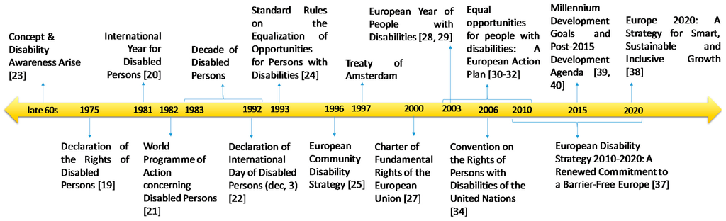
Figure 1.
Chronological timeline regarding the social awareness of disability.
Figure 1.
Chronological timeline regarding the social awareness of disability.

1.3. Problem Statement, Challenges, and Objectives of the Work
Current urban models, such as the sprawl city or zoning of uses, constantly generate transportation problems [41]. Transportation is one of the first challenges of sustainability. Facilitating movement and reducing its need by making the best use of the physical proximity relations and ensuring the access of the population to goods, jobs, and different services are the main objectives of transportation [42].
Sustainable transportation, taking into account the broad social diversity, is one of the main challenges faced in sustainable development, especially in the fields of transport and urbanism [43,44]. The implementation of effective public transport networks—environmentally and socially—in place of the intensive use of private vehicles; the creation of spaces designed to prioritize, preserve, and promote bicycle and pedestrian mobility—substantially affecting the urban relations and the city model, and the consequent decentralization of services and equipment in accordance with these scales, are essential strategies of sustainable mobility. These strategies are clearly related to applying the principles of universal accessibility and to the goals of transportation accessibility [45].
Currently, transportation accessibility has more opportunities in the recovery of existing cities and urban environments beyond the urbanization and construction of new urban areas [46,47]. Transportation accessibility is a determining factor of the habitability of cities, and it is an essential element in modern society. It provides security, comfort, and autonomy to pedestrians, cyclists, public transport users, and private motor vehicle users. It should be approached from the many aspects that affect accessibility. In this case, our research focuses on the field of pedestrian mobility, particularly in the most vulnerable group of people with disabilities, and addresses the study of urban accessibility—urban streets and urban public open spaces—as a means to enhance their participation and contribution in all aspects of social life.
Traditionally, cities have been developed based on a prototype of a user citizen without considering that a society is a diverse community. Thus, many population groups have been excluded from urban functioning, especially people with disabilities. The habitability of cities has been seriously damaged by this phenomenon along with the quality of life of all citizens, regardless of their limitations. Therefore, society has a major challenge: learning to live in a complex society, which involves learning to recognize, treat, and value the diversity of its individuals [48,49].
A considerable portion of the public built environment is not accessible enough. Its design does not take into account the requirements of people with mobility difficulties and other physical or sensory limitations—involving understanding, communication, or perception. Over 90% of the population think more resources should be invested in the removal of physical barriers [37]. Especially in built environments prior to the obligation to implement accessibility standards, it has performed actions that were uncoordinated, leading to results that have generated more uncertainty and confusion among citizens. Accessible routes without continuity, pedestrian crossings with a curb ramp on only one end, excessively narrow sidewalks that are occupied by street furniture, unsuitable slopes, a lack of rest areas for excessively long distances or on streets to ensure a leisurely pace, and a lack of markers and clear organization for different traffic flows are just some examples. In addition, many newly-constructed urban areas have insufficient urban accessibility.
To raise awareness of the dimension of the problem, we will mention as an example a reference in Spain. The Institute for European Studies performed a study in 2001 to assess the state of real accessibility in Spanish cities. It analyzed a representative sample of 729 urban routes—of 500 m long that were distributed among 80 municipalities—and conducted a supplementary survey of the main groups of people with disabilities. Only four of these routes could be described as pedestrian-accessible. It was virtually impossible to traverse routes of 500 m in the Spanish cities without encountering some type of urban barrier [50].
Accessibility is the aspect of the urban environment that most determines the habitable city model [51]. Thus, the level of accessibility of urban roads and public spaces absolutely affects the quality of life of citizens and limits their relational and social integration [52]. In fact, higher levels of demand on accessibility are always in the most developed societies. Therefore, to improve the habitability of cities, we must work to develop innovative proposals that will help ensure—short, medium, and long-term—the urban accessibility of different urban environments.
After a period of intense legislative development, a major challenge of European cities is knowing whether the protection provided by existing normative instruments on urban accessibility is effective and whether its application guarantees access to the urban environment for people with disabilities. To meet this challenge, methodologies recognizing the extent to which the implementation of these regulations can achieve their goals and if their priorities are adapted to the everyday needs of people with disabilities are needed.
However, it is not easy to locate accessibility deficiencies in cities currently. In many cases, the actions only apply the regulations without checking whether they are effective or whether there is a degradation that makes them unusable shortly. For example, a ramp on the sidewalks of the streets is made, but afterwards, a piece of street furniture that prevents the ramp’s use is installed.
This lack of supervision has justified this work and why technology is needed. Therefore, the main objective is to perform a continuous analysis of places in the city that confirms that the actions are effective and that they have not degraded over time. To achieve this, we aim to propose an automatic system based on our previous research on radio frequency identification—RFID—technology and new ICTs, such as the Internet of things—IoT—and cloud computing paradigms to evaluate, assess, and permanently monitor the programs for the achievement of equal opportunities for people with disabilities, according to the Convention of the United Nations [34] and the European Disability Strategy 2010–2020 [37].
1.4. Working Hypotheses and Contributions
RFID is widely used to obtain location information for objects and people tracking. In addition, more communication and processing capabilities are included on new devices embedded anywhere. Therefore, based on our previous experience with these technologies [53] and other previous research works [54], the working hypothesis of this research is that this type of solution can be used to trace users with and without movement disabilities when they move around the city and to check whether they are accessible.
The main scientific contribution of this work consists of combining several new technologies to design a method for the accessibility analysis of places in an urban environment. The method is based on the deployment of RFID technology along the studied places of the city—both indoor and outdoor—to check which route citizens with, and without, a disability follow around these locations. This infrastructure performs a local analysis and allows continuous supervision over time.
The remainder of this paper is organized as follows: Section 2 describes the related work on urban activities and technology used to improve sustainability in the city. The findings of this review define the starting point of our method and the expected benefits for improving urban sustainability; Section 3 explains the proposed method for improving accessibility and describes the computational architecture to implement it. To show how it works, indoor and outdoor examples are specified; Section 4 shows the experimentation conducted in which a case study has been developed. The examples show the practical interest of the proposed method to identify accessibility issues based on different citizens’ routes; and finally, in Section 5, some conclusions are drawn regarding the accuracy and deployment cost of the infrastructure.
2. Related Work
2.1. Urban Actions
European directives due to the current global context have influenced the actions developed to improve the urban accessibility of cities. The different proposals, both on the national and regional level, or the local level, have been articulated in three priority actions set out in the European Disability Strategy 2010–2020 [37].
- Increase awareness: It has awareness activities and campaigns regarding the capabilities and contributions of persons with disabilities in society; the participation of media and communication programs has also been encouraged so that society can understand the disability, and people with disabilities can know their rights and how to exercise those rights through appropriate information channels.
- Training: It has actions for learning and training professionals towards the approaches of “Design for All”—specific for products, services, and environments—so that in other areas, the architects, town planners, building engineers, and other design professionals that are building the urban environment can be informed at all times.
- Information: It has tried to streamline information on disabilities obtained mainly through surveys on different topics—as incomes, living conditions, workforce, and health—including specific topics regarding barriers to social integration. It has also provided statistics from this information and these efforts for the presentation of indicators to monitor their situation regarding the main objectives of the Europe 2020 Strategy—as education, employment, and poverty level.
In addition to the efforts above, the participation of social organizations and interested collectives must be promoted so that everyone can participate and contribute to achieving these objectives. This is the collaborative approach advocated by the Europe 2020 Strategy: the proposal for a common agenda that also allows all States to meet their diverse and specific needs to promote real growth for all and an integrated strategy based on collective mobilization in which Europe acts as a driving force [38].
Urban accessibility is, however, a separate issue locally. While national and regional plans have defined global guidelines and deadlines for action, the competent institutions that develop these guidelines and address the specific problems of accessibility in cities have been the councils on the local level. In fact, national and regional laws have been moving their application to local regulations.
In general, local institutions have materialized action programs based on removing barriers to participation—architectural, urban, and transport barriers—to make the physical environment accessible and have taken steps to ensure access to information—regarding diagnoses, rights, services, and programs—and communication. They have developed regulations to ensure access to different goods and services: housing, public buildings, roads, and urban spaces, and public transport. They have also been active in promoting the participation of disabled people in both processing these regulations and in different stages of planning, design, and building the environment.
Local accessibility plans—usually associated with regional strategies—have allegedly been operational instruments. They have been responsible for cataloguing existing barriers in the different municipalities and making proposals for their removal in accordance with current regulations. Gradually, their scope has focused on urban land. Increasingly, they include citizen participation, social awareness support and the support of better-trained technicians. However, the important legal and regulatory progress and the enormous technical and economic effort involved in the development of the local plans have failed to achieve the expected results. These efforts have not secured effective accessibility. In fact, if we study the example of Spain, there are not substantial differences between municipalities that have accessibility plans and those that do not have accessibility plans [55].
The legislative and regulatory development regarding accessibility is currently broad. However, cities are not accessible. A large number of citizens cannot move around the cities adequately. This may be due to the non-application of the rules or their ineffectiveness, a lack of sufficient development, a precise definition of the control mechanisms, sufficiently regulated sanctioning regimes, or jurisdictional conflicts between different public administrations.
The ineffectiveness of the rules highlights the inadequacy of their sectorial application, and how the model to remove barriers is applied to solve partial problems has been insufficient. A series of unconnected sectorial approaches cannot reach the dimension to solve the global problem of accessibility in cities. We must remove barriers in specific locations and progress towards models with comprehensive accessibility.
On the other hand, applying the rules is not feasible in all environments because one of the reasons for the lack of implementation of accessibility improvements is the high cost of rebuilding the cities’ infrastructure at a large scale. In those cases, technology can play a crucial role in facilitating accessibility actions.
From the first accessibility plans, great progress has been made towards models based on encouraging mobility, but more research is still needed to endow these models with the ability to integrate multiple aspects that can affect the accessibility of the urban environment. Accessibility can no longer be conceived separately; it should be integrated as a cross matter in any architectural, urban or mobility instrument that concerns the urban environment. The concept of a city contradicts isolated interventions in roads, squares or public equipment, and it demands an integrated approach that fits both its spatial complexity and the diversity of its inhabitants, as well as the variety of activities they perform [56].
2.2. Sustainability Enhanced by Technology
In the areas of urban planning and architectural constructions, technology development has been very significant in recent years. On one hand, the evolution of architectural, urban or building components, computers or electronic innovation have generated technological advances. On the other hand, new needs have also created new challenges for research. For example, the fields of automation, for the building—inside the buildings—and the management of basic urban services, including transport, as part of smart cities have been the areas that have developed technological processes. Beyond these fields, the presence of technology is not so evident in urban areas. From the urban and architectural perspective, we can differentiate several types of actions using technology to improve urban accessibility. They are described in the following table (Table 1).

Table 1.
Technological assistance to improve accessibility.
| Type | Meaning and Definition |
|---|---|
| Passive Technologies | Involves the application of technology to materials, components, and processes of urban construction |
| Active Technologies | Incorporate technology to define the behavior of urban elements according to the needs of a pedestrian or vehicular traffic |
| Autonomous Technologies | Technological elements that incorporate the inhabitants, themselves, to overcome the limitations of their disability |
Passive technologies to improve movement have been the most used technologies in the implementation of accessibility measures. The first actions of removing architectural barriers and barrier-free designs were accessible routes. Accessibility standards have focused almost exclusively on this demand, encouraging the development of comprehensive support technologies: non-slip flooring, strips of different texture and other materials, standard elements to build proper slope ramps, curb ramps on sidewalks, elements of integrated street furniture that do not reduce step size, and other protective elements in crosswalks and on slopes in general.
Moreover, the active technologies endow the spaces with a smart category. In some cases, technologies have been incorporated into the elements of street furniture to develop different functions. To organize traffic flow—pedestrian and vehicular traffic—automatic bollards are arranged—elements that can stay or hide—and at certain times and routes allow the passage of vehicles. These elements can also be driven by remote control by authorized people and can even work in connection with traffic lights. Some models include lighting systems. To determine the amount of time that pedestrians have to cross the traffic routes, traffic lights that emit sound and light signals can also be operated with remote control. Thus, the times of the acoustic signal can be adjusted at the beginning and end of the action and can guide action during development. The acoustic signal can also be replaced by a vibration. Remote controls and mobile devices that have incorporated this technology can also receive information from other transmitters regarding specific route guidance, the nearest accessible transport, or the nearest shops and businesses that have this technology. In many cases, clear and complete signaling has been incorporated—standard—as well as acoustic information—code and speech—to supplement visual or tactile information boards—embossed and Braille.
Additionally, to accommodate the use of mechanical stairs to the needs of different people, they have incorporated mechanisms to stop the operation and to transform several rungs on a platform while the action is performed. Other mechanical ramps also have devices to stop and activate the operation, as well as systems of tactile and visual warning and an audible alarm with visual impacts. The landscape has integrated exterior lifts, with perfectly accessible cabins, automatic telescopic opening doors with sensors that prevent their closure while people are detected, light signals that confirm drives and telephone lines. Other lifting devices are also integrated: platforms attached to stairs with sensors that by crushing or beating, automatically stop and incorporate sound and light signals or vertical platforms at street level in case of an accident.
Finally, autonomous technologies that integrate the inhabitants, themselves, into the urban environment are composed of accessible vehicles, wheelchairs, and prostheses or implants, among many others [57].
The technologies contribute substantially to offset the limitations of universal design. Technology can achieve levels of autonomy and independence well above solutions that allow barrier-free construction. The most important solution for providing an accessible environment for the disabled is to rely on technology. Technological development cannot be excluded from studies of accessibility. Its advances directly affect the quality of life of people with disabilities. However, technologies can serve beyond the technical support—individual or collective—because of the way they have been practically used. New technologies are great tools to facilitate access to the environment and enhance the participation of people with disabilities. Presently, we face a new challenge: failing to consider technology as an added design feature and incorporating it with greater commitment as part of the urban organism.
The complexity of public space/correlation of parameters—urban planning, transport, sociology, and economics—requires that mobility issues are examined in terms of urban life as a whole by avoiding artificially segregating each of the issues. Accessibility should be incorporated into the city and should become an automatism. An accessible city with technology applied to facilitate mobility and the relationship of people with their environment is complementary and constitutes a comprehensive set.
New ICTs bring opportunities for improving accessibility in modern cities and for reducing the cost of implementing accessibility actions. The aforementioned u-Cities concept offers connectivity, a power supply, and interoperability for ubiquitous sensory networks on which to build services for disabled people [58]. IoT platforms can provide ad hoc information and services to users and the government so that they can make efficient decisions and so that the management of the environment we inhabit becomes possible. For example, interactive street maps depict geographical information and identify objects targeted to the user’s special needs or to identifying emerging accessibility issues due to the daily dynamics of the city and its evolution in time. In short, this use of technology maintains the sustainability and quality of life of citizens [10,14].
2.3. Dynamic Analysis of Urban Accessibility
Traditionally, the most used method to obtain information on urban accessibility is made by means of evidence, street observation and audits [59], interviews [60,61], and surveys/questionnaires [55,62,63,64,65,66,67,68,69,70] from authorities, disabled people, and other interested groups—friends and family. From the previous data, other proposals are based on mathematical and/or statistical approaches to analyze and evaluate the accessibility level of the city [70,71,72,73]. These participatory processes are certainly a challenging area of research for improving accessibility in urban areas. However, these methods cannot be performed very frequently and they have rapidly become obsolete. Another issue is the difficulty of obtaining real dynamic information for citizens’ movements by means of interviews and surveys/questionnaires because users cannot answer questions on how they use the infrastructures. In this way, self-reporting tools can be a low-cost strategy to obtain information through user collaboration [74,75]. However, in this case, there is only evidence from the sites reported and when the users decide to submit it. Thus, the administrators cannot build knowledge from an entire area of the city or regarding an accessibility action made.
The use of technology to assess the accessibility of urban environments has been mostly associated with processes for informing citizens about the number of opportunities—services available for a range of activities, such as shopping—at a certain time and place. The logic of these applications is that the accessibility of an environment is greater where there are a greater number of opportunities, regardless of the capabilities of the user population. There are many institutional web pages and “apps” with accessibility information and an assessment of urban elements—curb ramps, reserved parking, and narrow sidewalks. These applications are focused on services offered to disabled people [76]. These processes have been based mainly on the calculation of close relationships and the intensities of use and have been served primarily by the Global Positioning System—GPS—technology for positioning and by the Geographic Information System—GIS—for data visualization and spatial analysis, which is one of the applications that most impacts the planning of itineraries—travel time. Progressively, the dimension of disability has been considered by introducing the concepts of absolute and relative access to measure time differences in the implementation of specific courses or the impact of the elimination of certain obstacles. Thus, the main challenge of these processes was to extend and improve the individual assessment of the accessibility of the environment [77,78,79,80,81,82] and to analyze the evolution of their dynamics—for example, whether these adapted resources are used.
To address this problem adequately, it would be useful to know the habits for the movement of citizens, with or without movement disabilities, around the city. In this way, dynamic knowledge to verify the presence of mobility difficulties or to determine corrective actions can be obtained. For example, the City of London has an “Information System” on the transport routes of travellers through its public transport system from which it is possible to analyze the different routes and transport times of people with, and without, disabilities [83].
The citizen track-and-trace issue is not new, as evidenced by the number of studies on this topic. Indeed, there is some concern about maintaining user privacy due to the proliferation of systems and the high penetration rate of mobile devices in the hands of citizens. However, the benefit of knowing citizen’s traceability information for the design of cities spur studies and works that try to obtain this information and preserve the privacy of citizens. The following table (Table 2) describes a non-exhaustive set of works that are a representative sample of the projects, studies, and methodologies developed for this purpose.
Table 2.
Technological projects to analyze movement accessibility.
| Project/research | Year | Methodology/Type | Aims |
|---|---|---|---|
| Time-Geographic Approach [79] | 2004 | GIS-based system | 3D geovisualization of human activity patterns |
| Route navigation method [80] | 2007 | GIS-based system Navigation services | Propose a route navigation method for disabled access |
| Destination accessibility [81] | 2012 | GIS-based system | Assessing accessibility via public transit and walking |
| Transport Accessibility Analysis [82] | 2015 | GIS-based system | Assessing sustainable transport in London |
| Personalized Accessibility Maps [77] | 2013 | GIS-based system Navigation services | Personalized accessibility maps |
| Routing Maps [78] | 2009 | GIS-based system Navigation services | Routing for wheelchair navigation |
| London Transport network [83] | 2014 | Efficiency analysis | Improving the accessibility of urban transportation networks |
| Planning Support System [68] | 2014 | Efficiency analysis | Optimal route finding for wheelchair users |
| A fuzzy logic map matching [84] | 2012 | GPS-based system | Mapping wheelchair movements on sidewalks |
| RouteCheckr [85] | 2008 | GPS-based system | Routing for mobility impaired pedestrians |
| Path 2.0 [86] | 2010 | GPS-based system | Generation of accessible routes |
| EasyWheel [74] | 2011 | Social Community System | Generating a social value and accessible information |
| IBM Sidewalks [75] | 2013 | Collaborative web platform | Identification of accessibility issues in the city |
The main technology created for acquiring citizen’s movements is GPS. With GPS, we can precisely and easily obtain our position on the world map. It is used for drivers and pedestrians to orient their location because it has become quite affordable. In addition, it is currently integrated into many devices such as mobile phones or other ubiquitous devices. With this technology, by having the exact location of people in real time and the trajectories they have followed, it is possible to study their habits of movement and even predict their location at a certain time of day. However, the use of GPS raises several issues that may be resolved for our purposes: the most important of them is that it is a technology that is used for only outdoor scenarios. It does not work inside buildings, and it can be inconvenient when designing a general method that is valid in all contexts. The other issue is the transparency of use: access to the positioning data of users requires that they allow it; they must configure or install an application designed to perform this data collection on their mobile devices. This configuration involves extra effort that everyone may not be willing or able to undertake. Finally, although GPS functionality is present in most modern mobile devices, it is off most of the time because its operation produces high power consumption. Therefore, users may be reluctant to spend their device’s battery for this purpose.
Other communication technologies such as the Global System for Mobile communications—GSM—, Long Term Evolution—LTE—or local area wireless computer networking—WIFI—can take advantage of the high penetration rate of mobile devices in modern societies. However, there are several drawbacks to consider. These technologies were not designed for user tracking. In their general use, the accuracy of the user’s position is not suitable for this purpose. To overcome this issue, it is necessary to install a redundant infrastructure to perform triangulation, which implies higher cost. Another issue is privacy. These communication technologies are aware of the presence and identity of each connected device, and thus, the user's identity is known. Finally, high power consumption is a serious disadvantage for this purpose because the mobile devices must be connected even when the user is not using them.
An alternative to those technologies for the sensorization of citizen movement is to use the RFID communication technology [87]. This type of technology may also play an important role in designing user-centric applications in both indoor and outdoor environments due the proliferation of mobile devices equipped with RF reading capabilities and RF tags. Therefore, this technology is present in a multitude of objects and devices that people wear. In many cases, they are integrated into standard cards made of plastic, with functions that include identification and access, such as credit or debit cards, or even paper tags on clothing.
In this way, recent studies have been developed to take advantage of this functionality for tracking people and also for improving accessibility. In this last case, RFID readers have been deployed throughout the city to facilitate the use of urban public transportation by people with disabilities [88]. In this regard, studies have been conducted for track-and-trace functions in indoor and outdoor environments. For example, for outdoor environments, the city of London introduced a system for data collection in its transportation network, including buses, subways, and trains [89]. The idea was to track users in the transport network through payment and access cards equipped with this communication technology. With the information gathered, the level of use, number of travellers, and the habits of public transport users in the city were determined so that we would know the stations, breakpoints, origin, and destination of the network travel stream. They have also been implemented indoor systems that know citizen movement flows, such as visits per museum [90], or the elderly living alone [91]. With these results, movement patterns were obtained along with design actions to improve user satisfaction.
RFID technology overcomes some of the disadvantages described for GPS because it does not require considerable cooperation from the user, and it minimizes energy costs for the devices. However, its use for tracking does not obtain exact locations, but the temporal location marks are limited to the locations of antennas or signal readers. Thus, the received information must be processed to be useful for tracing. Then, the readers should incorporate computing modules to perform this function. In addition, the scope of this technology is not comparable to GPS cover because it depends on the positions in which the antennas are placed and the gain they use.
2.4. Findings
A review of the efforts and initiatives for urban accessibility has significant shortcomings. The methodologies used presently have served to eliminate some of the barriers in a controlled urban environment, but they do not preserve the new urban spaces. The sectorial actions—developed in concrete times and places—have neglected the transversal nature of accessibility and the importance of maintaining their quality over time. The application of local accessibility standards is already common practice; however, evaluating their effectiveness has not been established as part of the process.
There are many movement barriers, but few efforts are dedicated to analyzing possible causes or elements that contribute to generate them. The modes of behavior for different groups to compare and detect inequalities have not been studied: that is, how do disabled people enjoy and use urban spaces, services, or equipment versus others.
There are many initiatives to analyze urban accessibility by means of street observation, interviews, and questionnaires, but they do not use the new possibilities that technology offers. In this way, there are some projects based on collaborative web platforms, GIS, and GPS technologies to obtain patterns, maps, and routes based on users’ movement habits. Obtaining the real dynamic information of citizens by means of localization and the tracking of users can provide valuable information to improve accessibility.
Currently, new trends on smart and ubiquitous city development provide other ways to dynamically analyze and improve accessibility. RFID technology is a good alternative that can be used to design methods for tracking users in urban contexts in both indoor and outdoor environments.
3. Computational Method for Analysis of Accessibility
Once the problem has been described from the hypothesis established and from the findings of previous studies, we propose a novel method in this paper for analyzing accessibility in urban environments. Next, the proposed method will be implemented by developing a computational system described in the following section. Finally, the proposal possibilities will be demonstrated by performing a simulation example in a real environment.
The main features of this method are: it uses modern communication technology that is easy to deploy; it provides a mechanism to evaluate the efficiency of the accessibility actions performed; and it engages users in the analysis of accessibility at a very low-cost for them.
The development process of the method has taken into account the integration of several strategies, paradigms, techniques, new technologies, and IoT solutions to build a comprehensive system for accessibility assessment in city working environments. We will work with technologies that can be integrated as part of the urban context. These integrated technologies aim to generate a sufficiently simplified procedure capable of driving the evaluation of the effective accessibility of cities, controlling maintenance—regularly and systematically—and providing support for prioritizing improvement actions that are performed in a public space. We also want to record information and geospatial data on the actual state of accessibility, its evolution, and influence from the functioning of the city itself and the ongoing relationship with disabled persons, the main group affected by accessibility issues.
The proposed method for urban accessibility analysis is mainly based on the knowledge of the habits for citizens’ movements, with or without disabilities, around specific places of the city. A comparative analysis of the routes followed in each case can show the effectiveness of the actions of urban accessibility, whether they are being used properly, and their degradation over time.
This system can be complementary to other qualitative methods, such as questionnaires and surveys from users. Of course, signing up is also voluntary and anonymous. Personal user information does not need to be collected to perform the tracking versus other technological approaches based on GPS or WIFI schemes, which require the identity of the user’s device to connect it to the system.
In addition, the proposed method only needs to know the route followed by users in certain areas—containing accessibility actions—and it is not intended to be a Real-Time Location System—RTLS. For this reason, it is not necessary to cover large geographic areas. We only need to locate the infrastructure in these areas of interest. In this sense, this proposal is simpler than other large-scale proposals.
This method is based on experience and previous research work regarding citizens’ traceability and the distributed systems made by this research group [53,54], which improve the current track-and-trace system proposals for the acquisition of the locations of citizens in heterogeneous and uncontrolled environments, both indoors and outdoors, to facilitate the transparent incorporation of citizens into the system. For acquisition of user’s locations, we will use RFID communication technology. This option has an increasing and continuous implementation, and currently, many mobile devices may incorporate it. The overall architecture is shown in Figure 2.

Figure 2.
Architecture of the computational model of citizens’ traceability.
Figure 2.
Architecture of the computational model of citizens’ traceability.
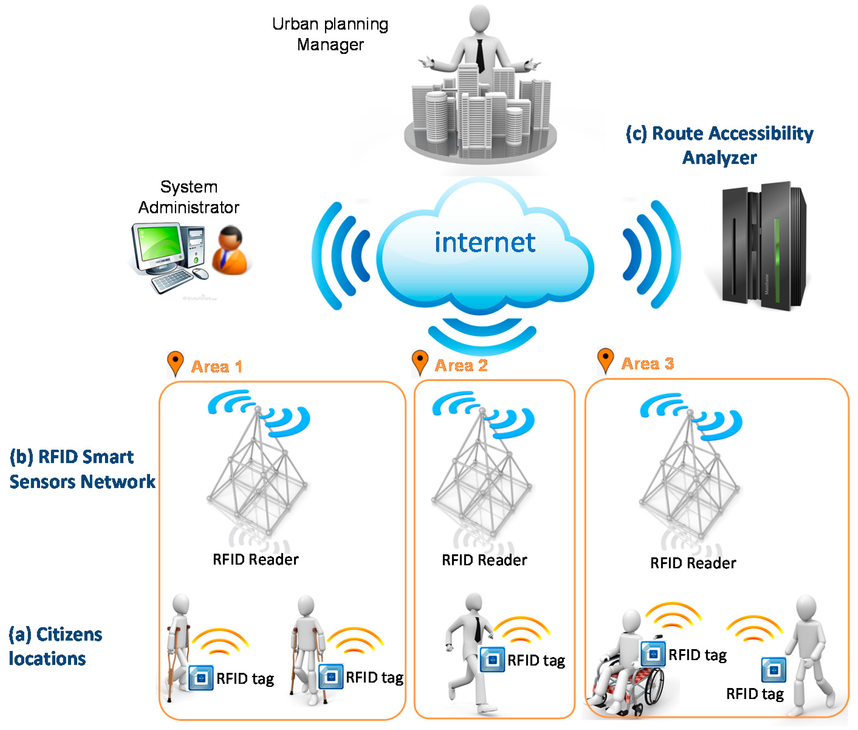
As shown, it is composed of a distributed part (Figure 2a,b) and a centralized part (Figure 2c). The distributed part implements the data acquisition model, which is made up of the RFID smart sensor network and RFID tags. The centralized part corresponds to the inference modules, information management system, and on-line interaction applications with the government organizations. Next, each part is defined.
3.1. Distributed Infrastructure Design
The main objective of the distributed infrastructure is to obtain the position of citizens during their movement around the city in both indoor and outdoor environments. RFID technology consists of two types of elements: the readers that emit the RF signal and the receivers (tags) worn by users. The tags contain a unique identifier that allows them to perform their function. Additionally, this technology provides installation options with passive or active receivers according to the desired range and complexity. In the case of passive receivers, no power supply is required for tags [87], which reduces the drawbacks of high power consumption and portability for the user and enables its use for extended periods of time. Although the main use of these cards is not for tracking, with the proposal described in this paper, we can take advantage of the card identifier to trace the route that the citizen follows along the city map.
The method must distinguish between two types of people to be useful for the model: those persons who have some type of disability versus those who do not have a disability. This distinction must be made explicitly through the collaboration of citizens with disabilities by associating their location to this feature. In this way, it will make it possible to discriminate the flow of movement between the two types of citizens and draw different patterns and conclusions from it.
The use of RFID communication technology requires the installation of a network of RFID readers that capture the tags carried by citizens. This part of the distributed infrastructure must only be deployed in special interest areas. Therefore, our proposal is to establish a network of smart RFID sensors located throughout the places to be analyzed for reading citizens’ locations. For example, the next figure (Figure 3) depicts two urban scenarios—indoor and outdoor—where accessibility actions have been performed—ramps on sidewalks, ramps at a building’s entrance, and different restrooms.

Figure 3.
RFID reader installation; (a) indoor and (b) outdoor.
Figure 3.
RFID reader installation; (a) indoor and (b) outdoor.
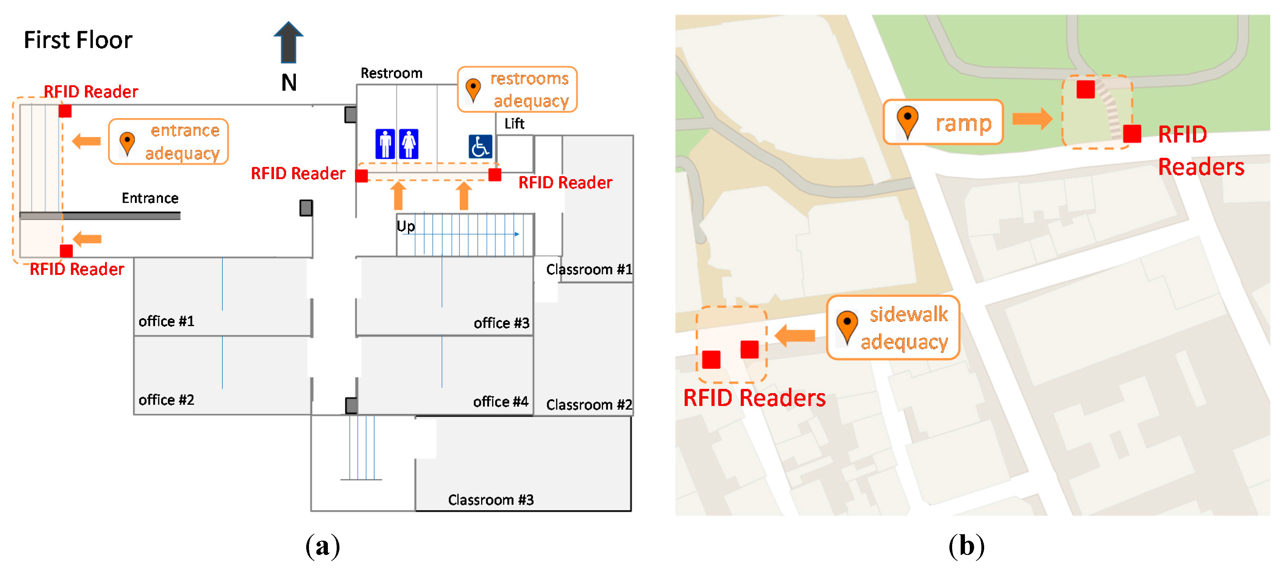
To determine what activities are occurring at a particular location, RFID readers can be installed. From the information collected by the sensors, we can analyze the utilization of the accessibility actions and their degradation over time. We can know whether a ramp is used by wheelchair users or whether the restroom is suitable for them because those resources are used by disabled people.
This part has the greatest economic cost for the infrastructure; however, the physical nature of communication technology enables the use of metal items on urban furniture as reader antennas [87]. In this way, elements such as streetlights, billboards, traffic signs or traffic lights can operate as antennae and, in addition, most of them are already connected. In this regard, the development trend of smart cities moves towards connected and ubiquitous cities where there are Internet access points and online services everywhere. This configuration option reduces the economic cost of deploying the necessary infrastructure. Alternatively, the distributed infrastructure of readers can be moved to temporarily check different areas of the city.
According to the features of RFID technology, it is possible to configure readers with coverage radios of several meters so that each of these readers can cover a corridor or a sidewalk of an entire street.
The idea is that the explicit collaboration of citizens for the activation of tags is required only for disabled citizens. These people will wear a special RF tag, which only provides information regarding her/his type of disability. No personal data are needed. We think that persons with disabilities stand ready to participate in this project due to their special interest in improving accessibility. Other people collaborate without a conscious awareness of doing so by means of the tags worn for other current RF applications—transport, payment, access, and labeling. These tags will be worn on clothes, in pockets, in bags, or in a wallet in a transparent manner and will interact as they move without the user being aware of it. Thereby, the tags worn by citizens can be activated when they walk down the street and pass by one of the installed readers.
In this context, the proposal consists of designing an RFID smart sensor to acquire citizens’ location information based on our design described in [53]. This device consists of an RFID reader and an embedded processing element, which gives it the required local intelligence and functionality. The operation objectives of this device include the reliability of data delivery and time synchronization with the rest of the system. To meet these objectives, the integration patterns called guaranteed delivery and correlation identifier are used [92]. This ensures complete receipt of the necessary information to infer patterns of citizen flow without the loss or duplication of messages.
3.2. Centralized Infrastructure Design
The Route Accessibility Analyzer is a centralized part of the architecture as shown in (Figure 2c). This module must provide services and interfaces for whole system administration and for urban planning management. The main job of this centralized part is to receive the locations of citizens from the readers deployed when people go through target places. From this information, the system infers what the specific routes followed by users are, and then it can deduct its accessibility adaptation for public use.
This inference function is based on comparing the routes followed by disabled and general people and the mapping of accessibility urban actuations. Thus, where accessibility actuation exists, disabled people should use adapted places for them. After activation of the sensors, the Route Accessibility Analyzer starts this inference process. The general technical details of this idea regarding communication issues, message processing, timing and availability are explained in [53].
From the information received by the set of RFID smart sensors deployed, the citizens’ locations are structured and completed to build the citizen movement routes based on the places under study. As a result, the system can know where citizens have been and what route they used to go across these places. To illustrate the idea behind this method, two examples are described.
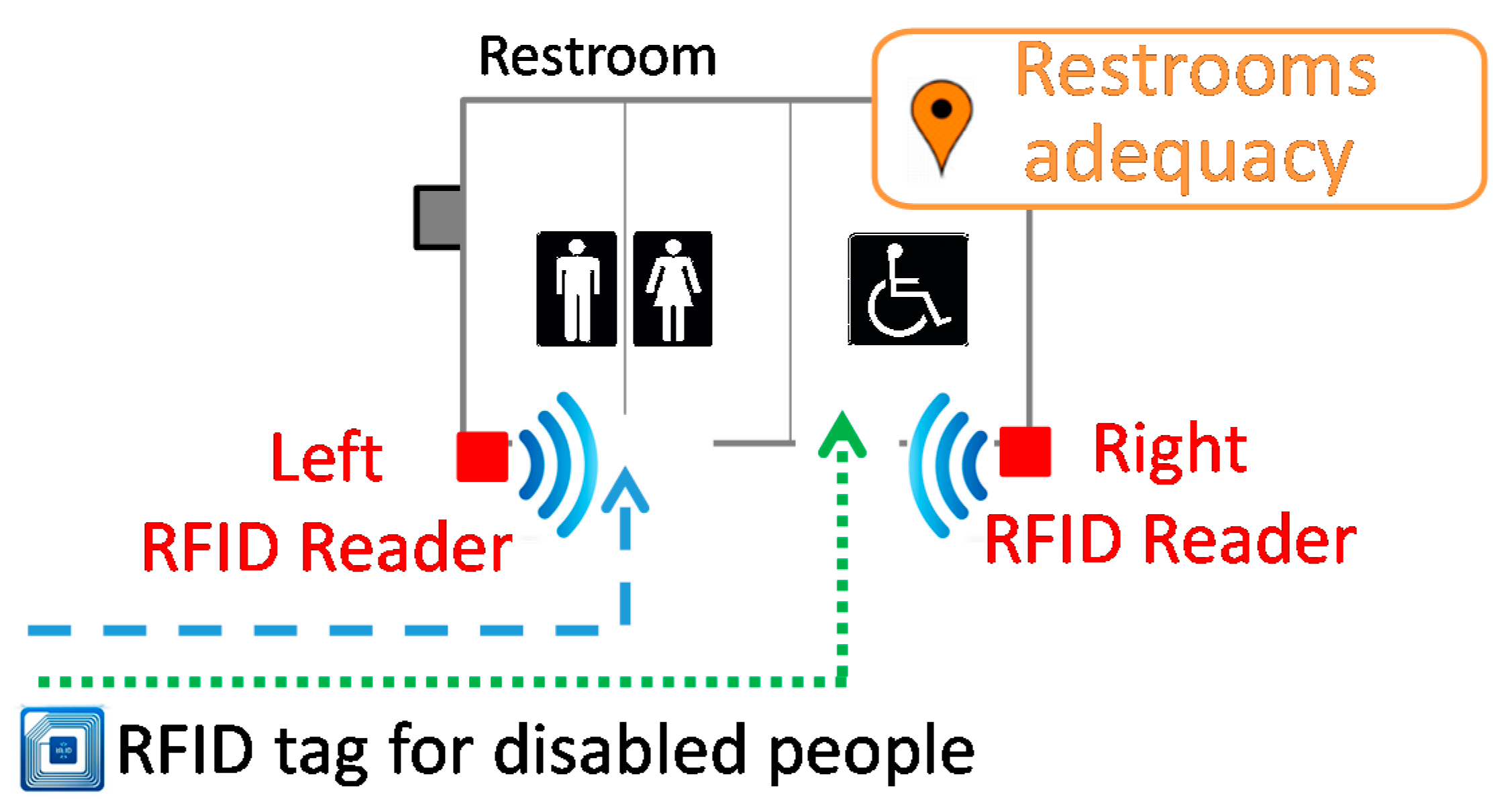
The next figure (Figure 4) shows restroom adequacy under the study depicted in Figure 3a. This detailed figure has two RFID readers installed—left and right. According to the reader activated and the type of tag read in each case, we can know whether disabled people are using an adequate restroom for them. Then, in the case of detecting situations where disabled people use the left restrooms, it would be a good idea to inspect the adequacy of the installations.

Figure 4.
Indoor location example.
Figure 4.
Indoor location example.
The second example is described in the next figure (Figure 5), where the details are shown in Figure 3b. In this case, an urban actuation was made to eliminate the curb of the sidewalk and allow easy access to a zebra crossing for wheelchair users. However, sometime after, an obstacle was installed on the sidewalk. Thus, disabled people had to go across the road to override this obstacle.
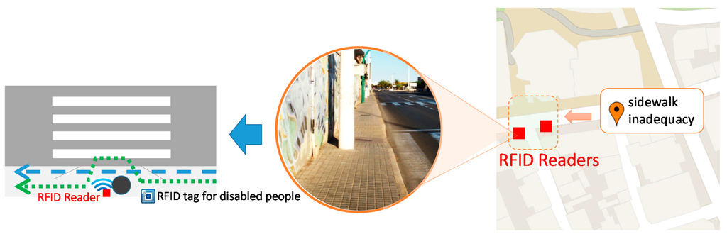
Figure 5.
Outdoor location example.
Figure 5.
Outdoor location example.
The new situation created can be automatically detected by using the proposed method because different routes are inferred between disabled and general people. Of course, these examples are very simple, but they are illustrative of the method’s operation and the results obtained.
Different routes can be processed by filtering by a time interval or a geographical area. The results will be presented as a service to the city administrators under request or when the system detects a dysfunction; that is, similar to the examples described above. These services are supported under the principles of the Service Oriented Architecture—SOA—paradigm and web services technologies. In this way, we can dynamically solve the problems of heterogeneity in the systems and technologies used for processing and monitoring the information regarding accessibility issues.
This service should be offered by the following two models. The first approach is based on the paradigm of Business-to-Customer—B2C—, oriented to offer a human-machine interface that allows a user to have direct interaction with the system, for example, through a thin client as a Web browser. The second approach is based on the paradigm of Business-to-Business—B2B—that allows us to connect consumers with the service system and to incorporate it as one process of an organization, but to improve the current system by adding more information decisions.
4. Experimentation and Discussion
Two test and working scenarios have been proposed: on the one hand, the capabilities of the reading technology and data processing have been validated; on the other hand, with the outcomes obtained, a simulated use case in a real environment for people with and without disabilities in a University context has been configured.
4.1. Experimental Setup and Implementation
The centralized infrastructure has been implemented in Java language. To provide data persistence, the MySQL community version database manager has been used. The B2C Presentation Module has been developed through Web technologies and JavaScript using the nodeJS framework to provide more accessibility and usability to the final users. The experiments of this section try to validate the operation of the modules described in the previous sections.
The reading tests were performed by simulating the actual portability of citizens, i.e., placing tags in clothes or on wheelchairs. These experiments show a sensor range up to three meters. The human body is opaque to the RF signal so that the tag is not read by the sensor when there is a human obstacle. This case can be common in urban settings with a high density of pedestrians. For example, in Figure 6a, the two persons on the left are in a shadow area produced by another person. However, this problem can be solved by distributing the antennas of the smart sensor in a configuration that minimizes occultation and shadow areas of the signal. Following the previous example, Figure 6b has a configuration that reduces the space that is not visible by the sensor.

Figure 6.
Configuration of the antennas and coverage of RFID sensors. (a) One antenna on the right side of sidewalk; and (b) two antennas on the right side of the sidewalk and on the ground.
Figure 6.
Configuration of the antennas and coverage of RFID sensors. (a) One antenna on the right side of sidewalk; and (b) two antennas on the right side of the sidewalk and on the ground.

4.2. Case Study
To explain our method and to see a simple practical situation of the concepts used, in this section, a case study is proposed on the campus of the University of Alicante. The case study will result in a better understanding of how the accessibility of infrastructures is detected, and it will help the university improve its sustainability on campus. The simulation made is not exhaustive and does not collect all existing situations, but it shows the possibilities of the proposed method.
The case study describes two situations that illustrate the different routes followed by people with movement disabilities who generally move about in wheelchairs. The data were introduced manually, and from this data, the system will provide the spatial and temporal visualization of areas with accessibility problems due to different routes between disabled and general people.
The implementation of this experiment consists of analyzing several places at the university to identify routes followed by disabled people and the differences with normal paths of general people. The reading capabilities of the distributed infrastructure have already been tested. Therefore, infrastructure deployment is not needed because a large transfer of students occurs in a short time and provides evidence that is sufficient to draw conclusions.
The experiments were performed during one normal school day. The number of students who passed through the interest areas during the entire day was approximately 600 of which only 5% are persons in wheelchairs. The simultaneous users that go across these places in both directions were up to three in the case of users without disability. The wheelchair users did not coincide at the same time. These data are perfectly driven by the proposed computational architecture. The distributed infrastructure can perform up to 400 concurrent readings per second; thus, it is useful for high transit areas.
Regarding power consumption, the rechargeable batteries of the readers are sufficient for one working day, and the users’ tags do not require a power supply. In addition, all university campuses are in the high bandwidth WIFI range to send the data to the server. Thus, the deployment of the whole distributed infrastructure along interest areas can be made without any wires.
The selection of the interest areas has been made by considering aspects of campus accessibility and the discrimination that can arise among wheelchair users. Although the campus at the University of Alicante meets the legal regulations regarding accessibility, this case study shows that there may be situations that are not detected or properly resolved.
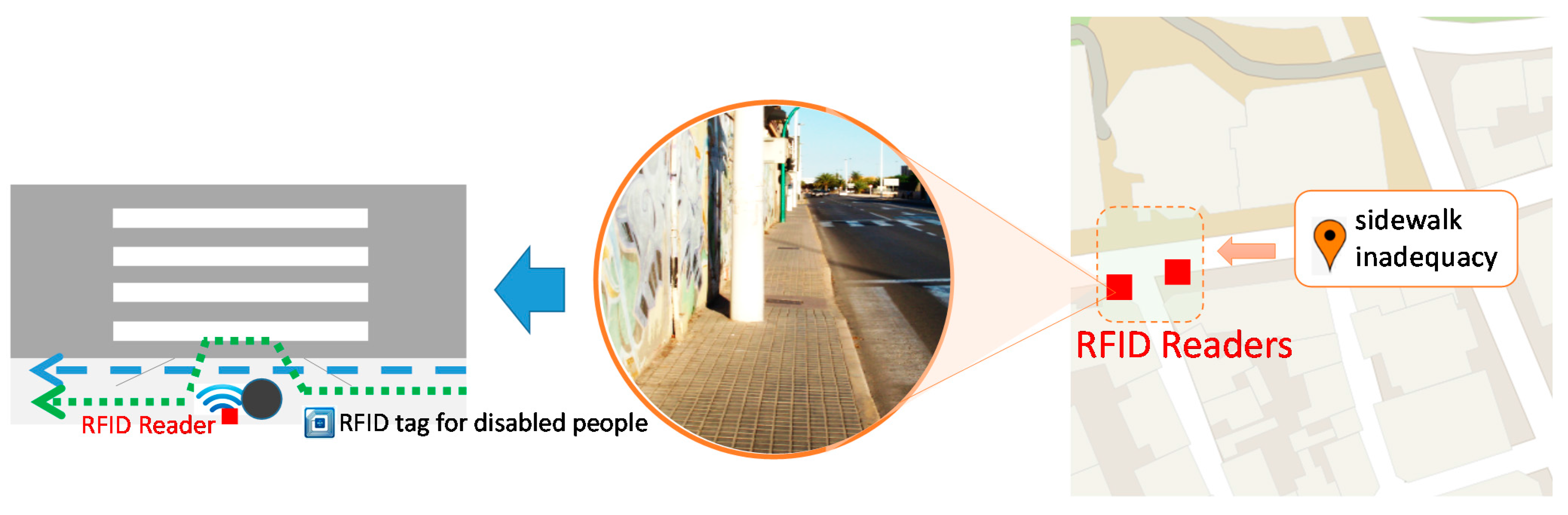
The centralized part of the system—the Route Accessibility Analyzer—infers different routes around the same area depending on the disability type of the users. To represent the results, the Analyzer uses a web-based user interface from a third party application—Google Maps JavaScript API v3—which shows the users-routes for people with (green dotted line) and without (blue dashed line) movement disabilities.
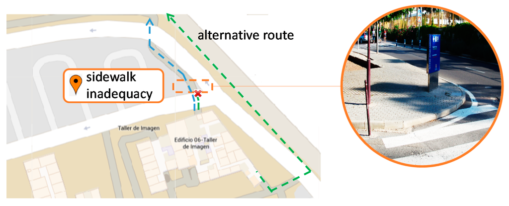
Figure 7.
Different routes detected due to movement disability. (coordinates: 38.388383, −0.512884).
Figure 7.
Different routes detected due to movement disability. (coordinates: 38.388383, −0.512884).

First, Figure 7 shows the different routes detected at a particular place on campus from the exit/entrance from/to the “Image Workshop” building to a northerly direction. It can be observed that the presence of curbs on a sidewalk provides an inadequate route. Thus, most wheelchair users use an alternative route even if it is longer.
The second example shows a different situation (Figure 8). In this case, the route followed by disabled people is conditioned by the presence of accessibility actions such a ramp. This point is located at the exit/entrance of the “EPSI” building. Of course, wheelchair users use the route with the ramp to overcome the stairs.
Figure 8.
Different routes detected due to movement disability. (coordinates: 38.386676, −0.511391).
Figure 8.
Different routes detected due to movement disability. (coordinates: 38.386676, −0.511391).

In this second case, there is not a considerable difference between both routes and even general students use the ramp route.
The two case studies analyzed demonstrate the difference in the routes based on the obstacles in the way as well as urban actuations involved in enabling accessibility. Of course, the implementation of these cases is not generalizable in a city because it would require placing an observer on every corner or at every interest place, but this is precisely why the method described in this paper has a practical application by replacing these human observers with RFID readers that automatically perform this process.
Other inclusive methods of city monitoring such as surveys, questionnaires and self-reporting do not have the same accuracy in providing users’ routes than the proposed method. They offer a static frame of accessibility reported in contrast with a dynamic analysis of real accessibility provided by our technology.
Furthermore, as shown in this case study, the economic cost of the necessary infrastructure will be gradually reduced with the development of IoT and on-line services in the city. Other applications of RFID technology can use the same infrastructure, such as access control or payment systems. In addition, it can be deployed on a smaller scale in special interest places, such as tourist areas and public buildings. Another deployment option can be to schedule intermittent installations that will progressively cover areas of the city.
5. Conclusions
The research presented in this paper proposes a computational method for identifying accessibility issues in the geographical context of a city. The implementation of this method consists of a computational distributed architecture based on current technology, including communications, cloud computing, and smart sensing. The acquisition of the user’s location is performed with RFID technologies using a smart sensor network distributed along indoor and outdoor interest areas.
The method determines the routes that are regularly chosen by people with and without disabilities and compares them to obtain valuable information. From this information, we can analyze and qualify the urban spaces and detect the occurrence of barriers for pedestrian movement created by different factors such as deficiencies in buildings, city degradation, or poor application of the accessibility regulations.
In addition, the proposed method can check citizen behavior for accessibility city actions performed and analyze the dynamic evolution of these actions over time. For example, we can detect urban spaces or routes that are highly frequented by disabled people or accessible urban spaces, temporally, or with certain frequency, that have become inaccessible urban spaces. The results obtained perform checking if the accessibility urban actions taken have had the desired effects, allowing urban integration and city sustainability. These approaches establish fundamental mechanisms for tracing and controlling effective citizen accessibility by ensuring continuous evaluation and maintenance in the city. The location study of interest places provides in-depth knowledge of the reality, and its diversity is useful for evaluation and maintenance processes. In addition, it allows us to resolve problems and their possible causes versus the efficacy or influence of their possible solutions.
The simulation made and the case study presented shows the workability of the proposal in providing an automatic mechanism to identify accessibility issues. The work involved in this research fits into the concept of a smart and connected city aimed at improving the lives of citizens by offering citizen-centric ubiquitous services.
The results from this paper suggest a possible new research direction: one direction is, as mentioned, combining other inclusive methods such as questionnaires, surveys, or self-reporting for acquiring the accessibility issues. Another research direction is the combination of obtained issues, with potential social media data such as Twitter and Facebook, to help develop broader patterns of citizen behavior and engagement, service, and facility utilization.
Author Contributions
All authors were involved in the foundation items. All authors wrote the paper and read and approved the final manuscript.
Conflicts of Interest
The authors declare no conflict of interest.
References
- European Union, Promoting Sustainable Urban Development in Europe Achievements and Opportunities. 1999. Available online: http://ec.europa.eu/regional_policy/sources/docgener/presenta/urban2009/urban2009_en.pdf (accessed on 1 November 2015).
- Vonkeman, G.H. Sustainable Development of European Cities and Regions. Springer, 2000. Available online: http://www.springer.com/us/book/9780792364238 (accessed on 9 November 2015).
- Waas, T.; Hugé, J.; Verbruggen, A.; Wright, T. Sustainable Development: A Bird’s Eye View. Sustainability 2011, 3, 1637–1661. [Google Scholar] [CrossRef]
- Hopwood, B.; Mellor, M.; O’Brien, G. Sustainable development: Mapping different approaches. Sustain. Dev. 2005, 13, 38–52. [Google Scholar] [CrossRef]
- Vallance, S.; Perkins, H.C.; Dixon, J.E. What is social sustainability? A clarification of concepts. Geoforum 2011, 42, 342–348. [Google Scholar] [CrossRef]
- Wolbring, G.; Rybchinski, T. Social Sustainability and Its Indicators through a Disability Studies and an Ability Studies Lens. Sustainability 2013, 5, 4889–4907. [Google Scholar] [CrossRef]
- Steinfeld, E.; Maisel, J. Universal Design: Creating Inclusive Environments; John Wiley & Sons: Hoboken, NJ, USA, 2012. [Google Scholar]
- Fietkiewicz, K.; Pyka, S. Development of Informational Cities in Japan: A Regional Comparison. Int. J. Knowl. Soc. Res. 2014. [Google Scholar] [CrossRef]
- European Smart Cities. Available online: http://www.smart-cities.eu/ (accessed on 11 March 2015).
- Yigitcanlara, T.; Ho Lee, S. Korean ubiquitous-eco-city: A smart-sustainable urban form or a branding hoax? Technol. Forecast. Soc. Chang. 2014, 89, 100–114. [Google Scholar] [CrossRef]
- Gabrys, J. Programming environments: Environmentality and citizen sensing in the smart city. Environ. Plan. D 2014, 32, 30–48. [Google Scholar] [CrossRef]
- Myungjun, J.; Soon-Tak, S. U-City: New Trends of Urban Planning in Korea Based on Pervasive and Ubiquitous Geotechnology and Geoinformation. Comput. Sci. Appl. 2010, 6016, 262–270. [Google Scholar]
- Neirotti, P.; De Marco, A.; Cagliano, A.C.; Mangano, G.; Scorrano, F. Current trends in Smart City initiatives: Some stylised facts. Cities 2014, 38, 25–36. [Google Scholar] [CrossRef]
- Lee, S.H.; Yigitcanlar, T.; Han, J.H.; Leem, Y.T. Ubiquitous urban infrastructure: Infrastructure planning and development in Korea. Innov. Manag. Policy Pract. 2008, 10, 282–292. [Google Scholar] [CrossRef]
- Yigitcanlar, T.; Han, J.H. Ubiquitous Eco Cities: Telecommunication Infrastructure, Technology Convergence and Urban Management. Int. J. Adv. Pervasive Ubiquitous Comput. 2010. [Google Scholar] [CrossRef]
- Yigitcanlar, T. Empirical approaches in knowledge city research. Expert Syst. Appl. 2014, 41, 5547–5548. [Google Scholar] [CrossRef]
- Anthopoulos, L.; Fitsilis, P. From Digital to Ubiquitous Cities: Defining a Common Architecture for Urban Development. Intell. Environ. 2010. [Google Scholar] [CrossRef]
- Nedovic-Budic, Z.; Williams, K. Becoming a uCity: The case of Chicago. J. Urban Manag. 2013, 2, 3–26. [Google Scholar]
- United Nations, General Assembly. Declaration on the Rights of Disabled Persons. 1975. Available online: http://www.un.org/en/ga/search/view_doc.asp?symbol=A/RES/3447%28XXX%29 (accessed on 11 March 2015).
- United Nations, General Assembly. International Year for Disabled Persons. 1976. Available online: http://www.un.org/en/ga/search/view_doc.asp?symbol=A/RES/31/123 (accessed on 11 March 2015).
- United Nations, General Assembly. World Programme of Action concerning Disabled Persons. 1982. Available online: http://www.un.org/en/ga/search/view_doc.asp?symbol=A/RES/37/52 (accessed on 11 March 2015).
- United Nations, General Assembly. International Day of Disabled Persons. 1992. Available online: http://www.un.org/en/ga/search/view_doc.asp?symbol=A/RES/47/3 (accessed on 11 March 2015).
- Stiker, H.J. A History of Disability; University of Michigan Press: Ann Arbor, MI, USA, 1999. [Google Scholar]
- United Nations, General Assembly. Standard Rules on the Equalization of Opportunities for Persons with Disabilities. 1993. Available online: http://www.un.org/en/ga/search/view_doc.asp?symbol=A/RES/48/96 (accessed on 11 March 2015).
- European Commission. Communication of the Commission on Equality of Opportunity for People with Disabilities. 1996. Available online: http://eur-lex.europa.eu/legal-content/EN/TXT/PDF/?uri=CELEX:51996PC0406&qid=1426235138066&from=EN (accessed on 11 March 2015).
- European Commission. Communication from the Commission to the Council, the European Parliament, the Economic and Social Committee, and the Committee of the Regions. 2000. Available online: http://eur-lex.europa.eu/legal-content/EN/TXT/PDF/?uri=CELEX:52000DC0284&from=ES (accessed on 11 March 2015).
- European Commission. Charter of Fundamental Rights of the European Union. 2010. Available online: http://eur-lex.europa.eu/LexUriServ/LexUriServ.do?uri=OJ:C:2010:083:0389:0403:en:PDF (accessed on 11 March 2015).
- European Commission. Council Decision of 3 December 2001 on the European Year of People with Disabilities 2003. 2001. Available online: http://eur-lex.europa.eu/legal-content/EN/TXT/PDF/?uri=CELEX:32001D0903&from=EN (accessed on 11 March 2015).
- European Commission. Communication from the Commission to the European Parliament, the Council, the European Economic and Social Committee, and the Committee of the Regions—On the Implementation, Results and Overall Assessment of the European Year of People with Disabilities 2003. 2005. Available online: http://eur-lex.europa.eu/legal-content/EN/TXT/PDF/?uri=CELEX:52005DC0486&from=EN (accessed on 11 March 2015).
- European Commission. Communication from the Commission to the Council, the European Parliament, the European Economic and Social Committee and the Committee of the Regions—Equal Opportunities for People with Disabilities: A European Action Plan [COM (2003) 650 final]. 2003. Available online: http://eur-lex.europa.eu/legal-content/EN/TXT/PDF/?uri=CELEX:52003DC0650&from=EN (accessed on 11 March 2015).
- European Commission. Communication from the Commission to the Council, the European Parliament, the European Economic and Social Committee and the Committee of the Regions—Working Together, Working Better: A New Framework for the Open Coordination of Social Protection and Inclusion Policies in the EUROPEAN Union [COM(2005) 706 Final]. 2005. Available online: http://eur-lex.europa.eu/legal-content/EN/TXT/PDF/?uri=CELEX:52005DC0706&from=ES (accessed on 11 March 2015).
- European Commission. Communication from the Commission to the European Parliament, the Council, the European Economic and Social Committee and the Committee of the Regions—A Renewed Commitment to Social Europe: Reinforcing the Open Method of Coordination for Social Protection and Social Inclusion [COM (2008) 418 final]. 2008. Available online: http://eur-lex.europa.eu/legal-content/EN/TXT/PDF/?uri=CELEX:52008DC0418&from=ES (accessed on 11 March 2015).
- European Commission. Communication from the Commission to the Council and the European Parliament—Towards a United Nations Legally binding Instrument to Promote and Protect the Rights and Dignity of Persons with Disabilities [COM(2003) 16 Final]. 2003. Available online: http://eur-lex.europa.eu/legal-content/EN/TXT/PDF/?uri=CELEX:52003DC0016&from=ES (accessed on 11 March 2015).
- United Nations, General Assembly. Convention on the Rights of Persons with Disabilities. 2006. Available online: http://www.un.org/en/ga/search/view_doc.asp?symbol=A/RES/61/106&Lang=EN (accessed on 11 March 2015).
- European Commission. Council Decision of 26 November 2009 Concerning the Conclusion, by the European Community, of the United Nations Convention on the Rights of Persons with Disabilities. 2010. Available online: http://eur-lex.europa.eu/legal-content/EN/TXT/PDF/?uri=CELEX:32010D0048&from=EN (accessed on 11 March 2015).
- Noga, J.; Wolbring, G. An Analysis of the United Nations Conference on Sustainable Development (Rio+20) Discourse Using an Ability Expectation Lens. Sustainability 2013, 5, 3615–3639. [Google Scholar] [CrossRef]
- European Commission. Communication from the Commission to the European Parliament, the Council, the European Economic and Social Committee and the Committee of the Regions—European Disability Strategy 2010–2020: A Renewed Commitment to a Barrier-Free Europe [COM (2010) 636 final]. 2010. Available online: http://eur-lex.europa.eu/legal-content/EN/TXT/PDF/?uri=CELEX:52010DC0636&from=ES (accessed on 11 March 2015).
- European Commission. Communication from the Commission—Europe 2020: A Strategy for Smart, Sustainable and Inclusive Growth [COM (2010) 2020 final]. 2010. Available online: http://eur-lex.europa.eu/legal-content/EN/TXT/PDF/?uri=CELEX:52010DC2020&from=ES (accessed on 11 March 2015).
- United Nations, General Assembly. Keeping the Promise: United to Achieve the Millennium Development Goals. 2010. Available online: http://www.un.org/en/ga/search/view_doc.asp?symbol=A/RES/65/1 (accessed on 11 March 2015).
- Wolbring, G.; Mackay, R.; Rybchinski, T.; Noga, J. Disabled People and the Post-2015 Development Goal Agenda through a Disability Studies Lens. Sustainability 2013, 5, 4152–4182. [Google Scholar] [CrossRef]
- Sohn, J.; Choi, S.; Lewis, R.; Knaap, G. Characterising urban sprawl on a local scale with accessibility measures. Geogr. J. 2012, 178, 230–241. [Google Scholar] [CrossRef]
- Macário, R. Managing Urban Mobility Systems; Emerald Group Publishing: Bingley, UK, 2011. [Google Scholar]
- Holden, E. Achieving Sustainable Mobility: Everyday and Leisure-Time Travel in the EU; Ashgate Publishing Ltd.: Hampshire, UK, 2012. [Google Scholar]
- Schmale, J.; von Schneidemesser, E.; Dörrie, A. An Integrated Assessment Method for Sustainable Transport System Planning in a Middle Sized German City. Sustainability 2015, 7, 1329–1354. [Google Scholar] [CrossRef]
- Marquet, O.; Miralles-Guasch, C. The Walkable city and the importance of the proximity environments for Barcelona’s everyday mobility. Cities 2015, 42, 258–266. [Google Scholar] [CrossRef]
- Bromley, R.D.F.; Matthews, D.L.; Thomas, C.J. City center accessibility for wheelchair users: The consumer perspective and the planning implications. Cities 2007, 24, 229–241. [Google Scholar] [CrossRef]
- Vural-Arslan, T.; Dostoğlu, N.; Köprülü-Bağbanci, Ö.; Akıncıtürk, N. Sustainable revitalization as a tool for regenerating the attractiveness of an inner-city historic commercial district: ‘Han District’as a case. Urban Des. Int. 2011, 16, 188–201. [Google Scholar] [CrossRef]
- Webb, J.; Williams, B.T.; Smith, K.H. Redefining Design and Disability: A Person-Environment Fir Model. In Universal Design Handbook, 2nd ed.; McGraw-Hill Companies: New York, NY, USA, 2011; pp. 43.1–43.8. [Google Scholar]
- Wiesel, I.; Bigby, C.; Carling-Jenkins, R. ‘Do You Think I’m Stupid?’: Urban Encounters between People with and without Intellectual Disability. Urban Stud. 2013, 50, 2391–2406. [Google Scholar] [CrossRef]
- Alonso López, F. Libro Verde de La Accesibilidad en España: Diagnóstico y Bases Para un Plan Integral de Supresión de Barreras; Ministerio de Trabajo y Asuntos Sociales: Madrid, Spain, 2002. (In Spanish) [Google Scholar]
- Vojnovic, I. Urban sustainability: Research, politics, policy and practice. Cities 2014, 41, S30–S44. [Google Scholar] [CrossRef]
- Clarke, P.; Ailshire, J.A.; Bader, M.; Morenoff, J.D.; House, J.S. Mobility disability and the urban built environment. Am. J. Epidemiol. 2008, 168, 506–513. [Google Scholar] [CrossRef] [PubMed]
- Mora-Mora, H.; Gilart-Iglesias, V.; Gil, D.; Sirvent-Llamas, A. A Computational Architecture Based on RFID Sensors for Traceability in Smart Cities. Sensors 2015, 15, 13591–13626. [Google Scholar] [CrossRef] [PubMed]
- Mora, H.M.; Gil, D.; Colom López, J.H.; Signes Pont, M.T. Flexible Framework for Real-Time Embedded Systems Based on Mobile Cloud Computing Paradigm. Mob. Inf. Syst. 2015. [Google Scholar] [CrossRef]
- Sala Mozos, E.; Alonso López, F. La Accesibilidad Universal en los Municipios: Guía Para una Política Integral de Promoción y Gestión; Institute for Older Persons and Social Services (IMSERSO): Madrid, Spain, 2006. (In Spanish) [Google Scholar]
- Joujje, I. Countering the Right to the Accessible City: The Perversity of a Consensual Demand. In Cities for All: Proposals and Experiences towards the Right to the City; Sugranyes, A., Mathivet, C., Eds.; Habitat International Coalition: Santiago, Chile, 2010; pp. 43–56. [Google Scholar]
- Helal, A.; Mokhtari, M.; Abdulrazak, B. The Engineering Handbook of Smart Technology for Aging, Disability, and Independence; John Wiley & Sons: Hoboken, NJ, USA, 2008. [Google Scholar]
- Jackson, M.; Gardner, Z.; Wainwright, T. Location-awareness and Ubiquitous Cities: A report to the U-City Research Institute, Yonsei University, S. Korea. 2011. Available online: http://eprints.kingston.ac.uk/20012/1/u-City_Korea_Report_-_22_June_2011.pdf (accessed on 10 September 2015).
- Mackett, R.L.; Achuthan, K.; Titheridge, H. AMELIA: Making streets more accessible for people with mobility difficulties. Urban Des. Int. 2008, 13, 81–89. [Google Scholar] [CrossRef]
- Hashim, A.E.; Samikon, S.A.; Ismail, F.; Kamarudin, H.; Jalil, M.N.M.; Arrif, N.M. Access and Accessibility Audit in Commercial Complex: Effectiveness in Respect to People with Disabilities (PWDs). Procedia Soc. Behav. Sci. 2012, 50, 452–461. [Google Scholar] [CrossRef]
- Venter, C.; Savill, T.; Rickert, T.; Bogopane, H.; Venkatesh, A.; Camba, J.; Mulikita, N.; Khaula, C.; Stone, J.; Maunder, D. Enhancing Accessibility for People with Disabilities Living in Urban Areas. 2002. Available online: http://www.globalride-sf.org/images/DFID.pdf (accessed on 1 July 2015).
- Beale, L.; Field, K.; Briggs, D.; Picton, P.; Matthews, H. Mapping for wheelchair users: Route navigation in urban spaces. Cartogr. J. 2006, 43, 68–81. [Google Scholar] [CrossRef]
- Soltani, S.H.K.; Abbas, M.Y.; Awang, M.B. Disabled Children in Public Playgrounds: A Pilot Study. Proced. Soc. Behav. Sci. 2012, 36, 670–676. [Google Scholar] [CrossRef]
- Soltani, S.H.K.; Sham, M.; Awang, M.; Yaman, R. Accessibility for Disabled in Public Transportation Terminal. Proced. Soc. Behav. Sci. 2012, 35, 89–96. [Google Scholar] [CrossRef]
- Le-Klähn, D.-T.; Hall, C.M.; Gerike, R. Analysis of Visitor Satisfaction with Public Transport in Munich. J. Public Transp. 2014, 17, 68–85. [Google Scholar] [CrossRef]
- Marco, D. Measuring the satisfaction of multimodal travellers for local transit services in different urban contexts. Transp. Res. Part A 2012, 46, 1–11. [Google Scholar] [CrossRef]
- Münchner Verkehrsgesellschaft mbH (MVG). Sustainable Mobility for Munich. 2010. Available online: https://www.mvg.de/dam/mvg/ueber/nachhaltigkeit/mvg-nachhaltigkeitsbericht-eng.pdf (accessed on 1 November 2015).
- Inada, Y.; Izumi, S.; Koga, M.; Matsubara, S. Development of Planning Support System for Welfare Urban Design—Optimal Route Finding for Wheelchair Users. Procedia Environ. Sci. 2014, 22, 61–69. [Google Scholar] [CrossRef]
- Kogaa, M.; Izumi, S.; Matsubara, S.; Inada, Y.; Gaidar, D. Proposal for Welfare Town Planning Method and Experimental Development of Support System for Persons with Disabilities. Procedia Environ. Sci. 2014, 22, 70–77. [Google Scholar] [CrossRef]
- Prasertsubpakij, D.; Nitivattananon, V. Evaluating accessibility to Bangkok Metro Systems using multi-dimensional criteria across user groups. IATSS Res. 2012, 36, 56–65. [Google Scholar] [CrossRef]
- Coppola, P.; Papa, E. Accessibility Planning Tools for Sustainable and Integrated Land Use/Transport (LUT) Development: An Application to Rome. Soc. Behav. Sci. 2013, 87, 133–146. [Google Scholar] [CrossRef]
- Soltani, A.; Allan, A. A computer methodology for evaluating urban areas for walking, cycling and transit suitability: Four cases from suburban Adelaide, Australia. 2005. Available online: http://128.40.111.250/cupum/searchpapers/papers/paper272.pdf (accessed on 9 November 2015).
- Church, R.L.; Marston, J.R. Measuring accessibility for people with a disability. Geogr. Anal. 2003, 35, 83–96. [Google Scholar] [CrossRef]
- Menkens, C.; Sussmann, J.; Al-Ali, M.; Breitsameter, E.; Frtunik, J.; Nendel, T.; Schneiderbauer, T. EasyWheel—A Mobile Social Navigation and Support System for Wheelchair Users. Inf. Technol. New Gener. 2011. [Google Scholar] [CrossRef]
- Shigeno, K.; Borger, S.; Gallo, D.; Ricardo, H.; Molinaro, M.; Cardonha, C.; Koch, F.; Avegliano, P. Citizen sensing for collaborative construction of accessibility maps. Int. Cross-Discip. Conf. Web Access. 2013. [Google Scholar] [CrossRef]
- Comai, S.; Kayange, D.; Mangiarotti, R.; Matteucci, M.; Ugur Yavuz, S.; Valentini, F. Mapping City Accessibility: Review and Analysis. Stud. Health Technol. Inform. 2015, 217, 325–331. [Google Scholar] [PubMed]
- Karimi, H.A.; Zhang, L.; Benner, J.G. Personalized Accessibility Maps (PAMs) for Communities with Special Needs. Web Wirel. Geogr. Inf. Syst. 2013, 7820, 199–213. [Google Scholar]
- Kasemsuppakorna, P.; Karimia, H.A. Personalised routing for wheelchair navigation. J. Locat. Based Serv. 2009, 3, 24–54. [Google Scholar] [CrossRef]
- Kwan, M.P.; Lee, J. Geovisualization of human activity patterns using 3D GIS. In Spatially Integrated Social Science: Examples in Best Practice; Goodchild, M.F., Janelle, D.G., Eds.; Oxford University Press: Oxford, UK, 2004. [Google Scholar]
- Izumi, S.; Kobayahi, G.; Yoshida, T. Route navigation method for disabled access GIS in consideration of abilities and psychologies. J. Digit. Inf. Manag. 2007, 6, 348–354. [Google Scholar]
- Mavoa, S.; Witten, K.; McCreanor, T.; O’Sullivan, D. GIS based destination accessibility via public transit and walking in Auckland. J. Transp. Geogr. 2012, 20, 15–22. [Google Scholar] [CrossRef]
- Ford, A.C.; Barr, S.L.; Dawson, R.J.; James, P. Transport Accessibility Analysis Using GIS: Assessing Sustainable Transport in London. Int. J. Geo-Inf. 2015, 4, 124–149. [Google Scholar] [CrossRef]
- Ferrari, L.; Berlingerio, M.; Calabrese, F.; Reades, J. Improving the accessibility of urban transportation networks for people with disabilities. Transp. Sci. Technol. Part C 2014, 45, 27–40. [Google Scholar] [CrossRef]
- Ren, M.; Karimi, H.A. A fuzzy logic map matching for wheelchair navigation. GPS Solut. 2012, 16, 273–282. [Google Scholar] [CrossRef]
- Völkel, T.; Weber, G. RouteCheckr: Personalized multicriteria routing for mobility impaired pedestrians. In Proceedings of the 10th international ACM SIGACCESS conference on Computers and accessibility, New York, NY, USA, 13–15 October 2008.
- Palazzi, C.E.; Teodori, L.; Roccetti, M. Path 2.0: A participatory system for the generation of accessible routes. Multimed. Expo (ICME) 2010. [Google Scholar] [CrossRef]
- Chawla, V.; Ha, D.S. An overview of passive RFID. Commun. Mag. IEEE 2007, 45, 11–17. [Google Scholar] [CrossRef]
- Zhou, H.; Hou, K.M.; Zuo, D.; Li, J. Intelligent Urban Public Transportation for Accessibility Dedicated to People with Disabilities. Sensors 2012, 12, 10678–10692. [Google Scholar] [CrossRef] [PubMed]
- SIMulacra Research Group. London’s Rail System as a Network. 2011. Available online: http://simulacra.blogs.casa.ucl.ac.uk/2011/06/londons-rail-system-as-a-network/ (accessed on 1 July 2015).
- Kanda, T.; Shiomi, M.; Perrin, L.; Nomura, T.; Ishiguro, H.; Hagita, N. Analysis of people trajectories with ubiquitous sensors in a science museum. In Proceedings of the 2007 IEEE International Conference on Robotics and Automation, Italy, 10–14 April 2007.
- Hsu, C.-C.; Chen, J.-H. A novel sensor-assisted RFID-based indoor tracking system for the elderly living alone. Sensors 2011, 11, 10094–10113. [Google Scholar] [CrossRef] [PubMed]
- Hohpe, G.; Woolf, B. Enterprise Integration Patterns, 1st ed.; Addison-Wesley: Boston, MA, USA, 2003. [Google Scholar]
© 2015 by the authors; licensee MDPI, Basel, Switzerland. This article is an open access article distributed under the terms and conditions of the Creative Commons Attribution license (http://creativecommons.org/licenses/by/4.0/).