Using UAV-Based SOPC Derived LAI and SAFY Model for Biomass and Yield Estimation of Winter Wheat
Abstract
:1. Introduction
2. Materials and Methods
2.1. Study Area
2.2. Field Sampling Design and Field Data Collection
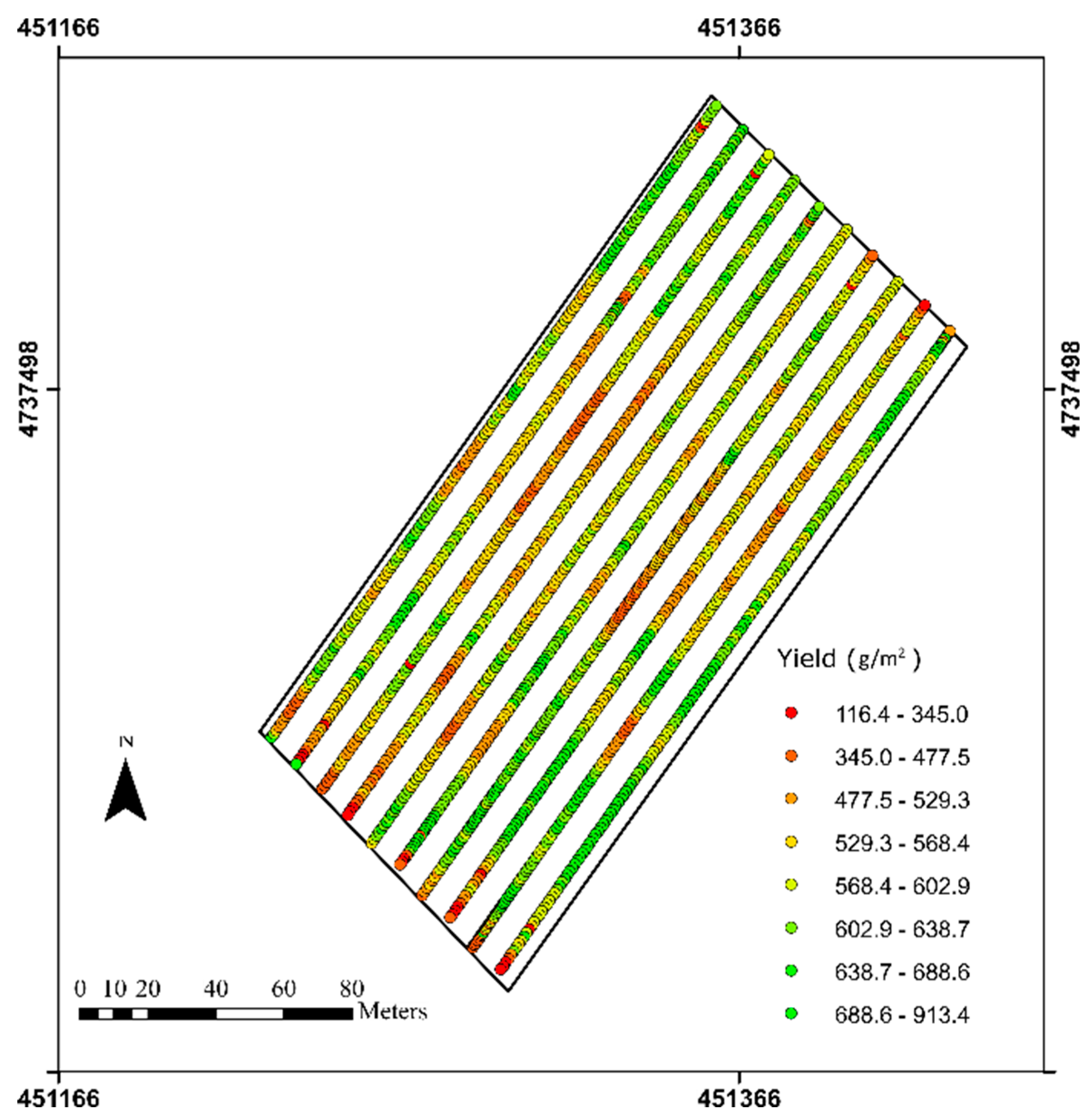
2.3. Combine Harvester Yield Data Collection
2.4. UAV-Based Image Collection
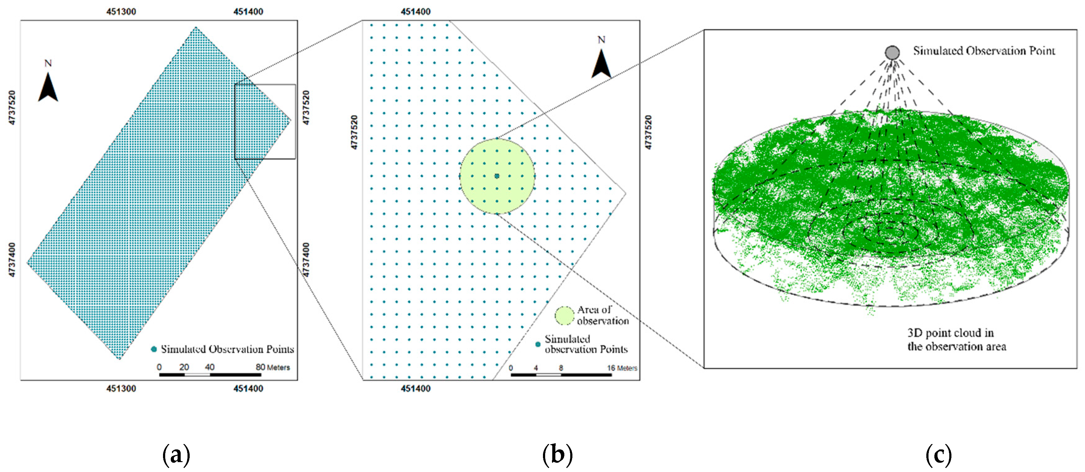
2.5. Simulated Observation of Point Cloud Method
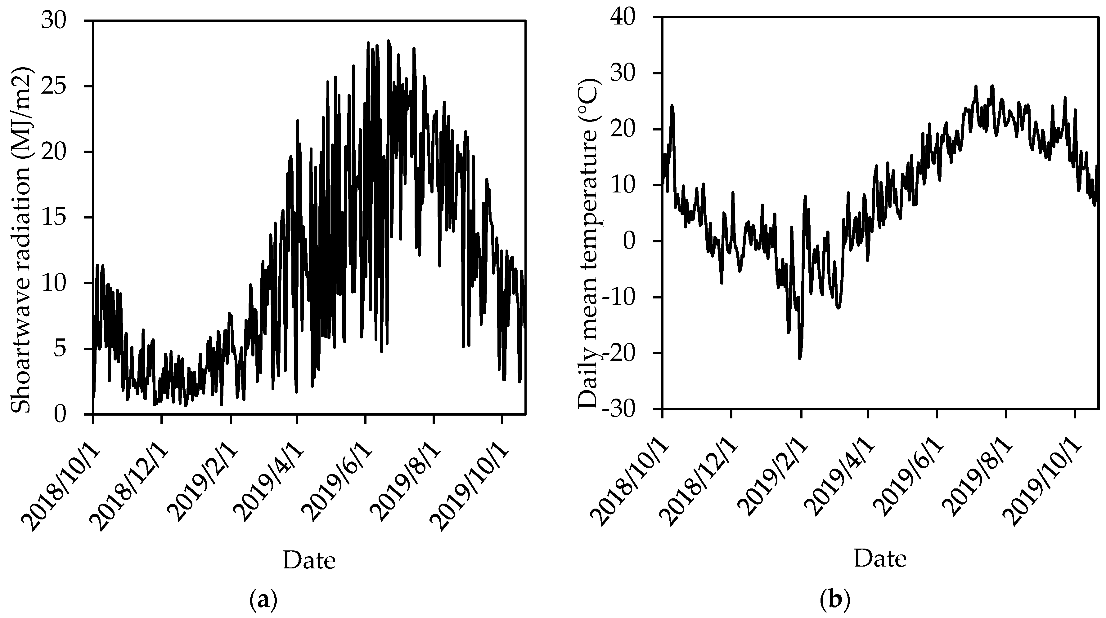
2.6. Weather Data
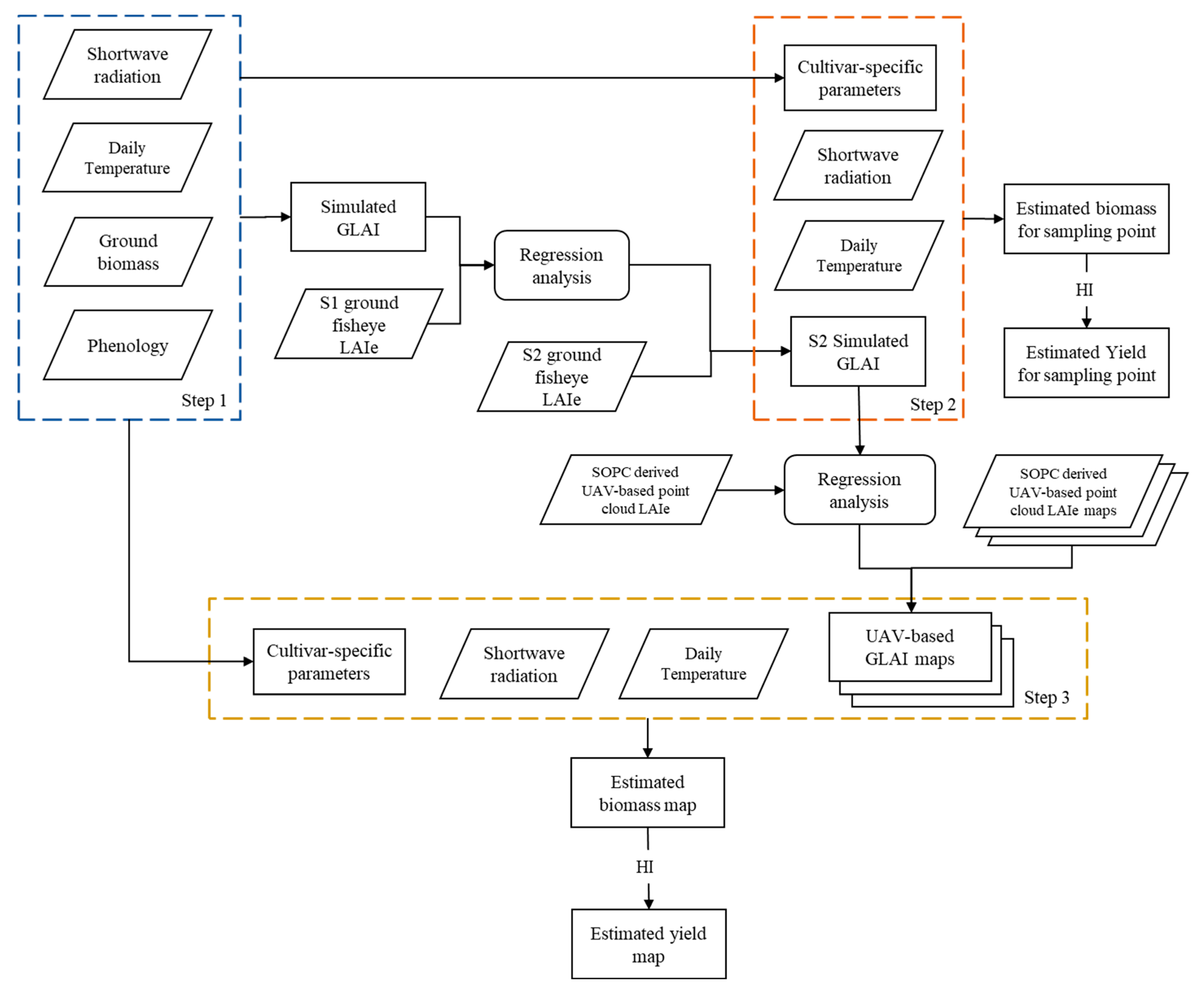
2.7. SAFY Model Calibration
2.8. Winter Wheat Parameter Estimation from Ground-Based Biomass Measurement
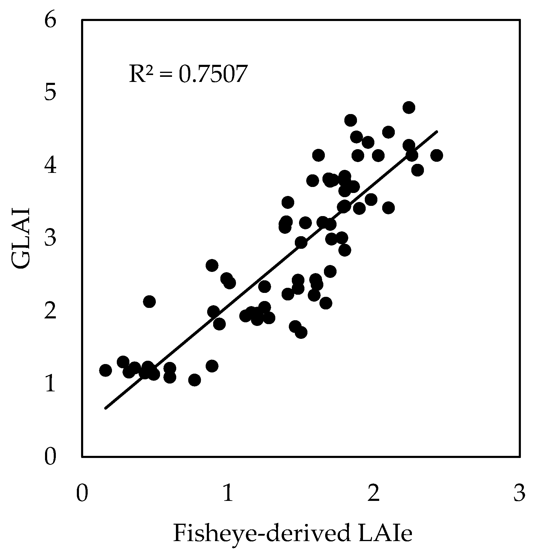
2.9. Fisheye-Derived GLAI and Model-Simulated GLAI
2.10. Final DAM and Yield Estimation Using UAV-Based LAIe in S2
3. Results
3.1. Determination of Cultivar-Specific Parameters
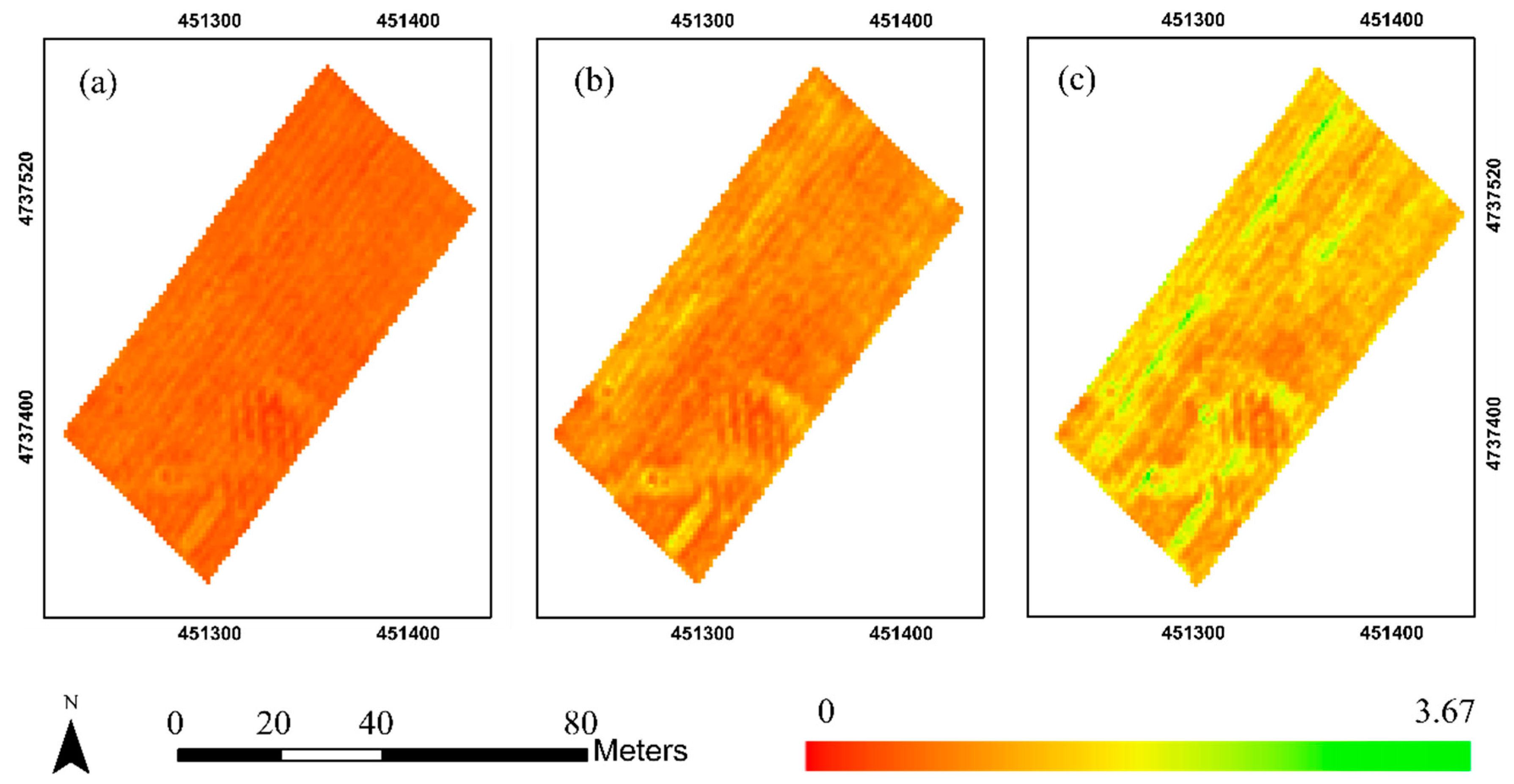
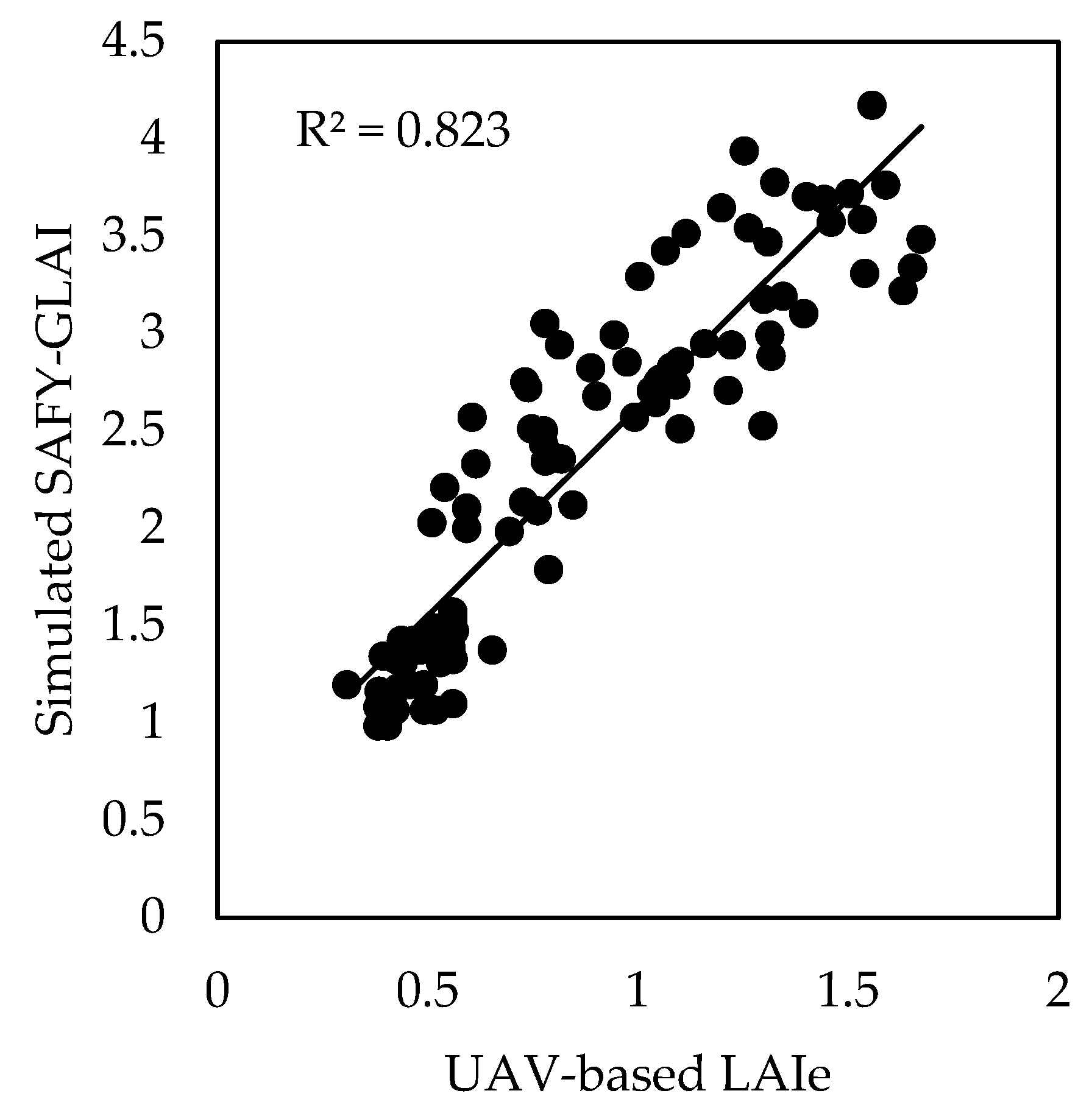
3.2. Relationship between Simulated SAFY-GLAI and Fisheye-Derived LAIe in S1 and S2
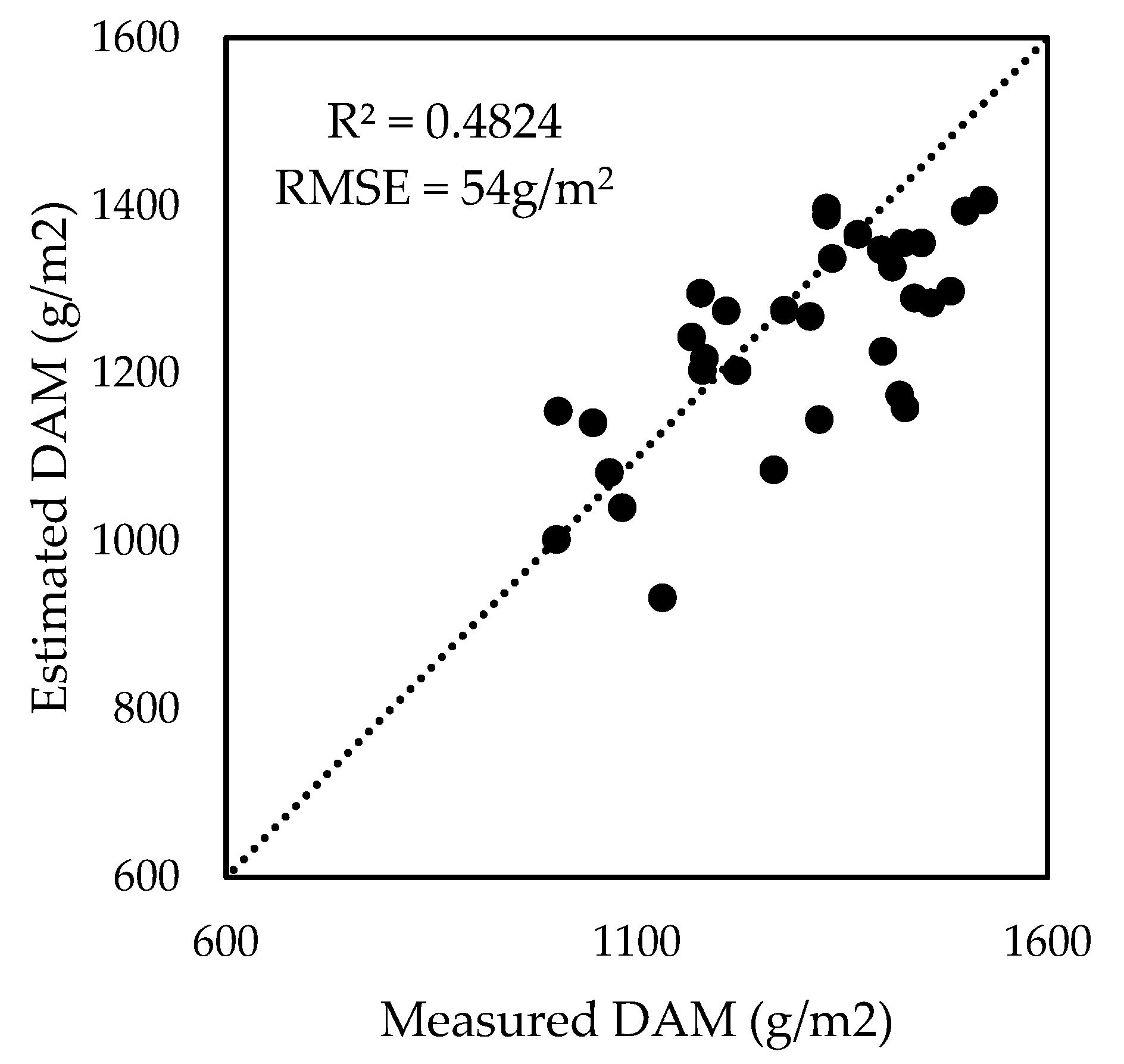
3.3. DAM Estimation Using UAV-Based LAIe Measurements
3.4. Comparison of True Grain Yield and Estimated Yield
4. Discussion
4.1. Cultivar-Specific Parameters Derived from the First SAFY Model Calibration
4.2. ELUE
4.3. Uncertainties of the Estimated Crop Biomass and Yield
4.4. Application and Contribution
5. Conclusions
Author Contributions
Funding
Acknowledgments
Conflicts of Interest
References
- Schimmelpfennig, D. Farm Profits and Adoption of Precision Agriculture; (Economic Research Report, 217); United States Department of Agriculture: Washington, DC, USA, 2016.
- Idso, S.B.; Jackson, R.D.; Reginato, R.J. Remote-sensing of crop yields. Science 1977, 196, 19–25. [Google Scholar] [CrossRef] [PubMed]
- Liu, J.; Miller, J.R.; Pattey, E.; Haboudane, D.; Strachan, I.B.; Hinther, M. Monitoring crop biomass accumulation using multi-temporal hyperspectral remote sensing data. Int. Geosci. Remote Sens. Symp. (IGARSS) 2004, 3, 1637–1640. [Google Scholar] [CrossRef]
- Toscano, P.; Castrignanò, A.; Di Gennaro, S.F.; Vonella, A.V.; Ventrella, D.; Matese, A. A precision agriculture approach for durum wheat yield assessment using remote sensing data and yield mapping. Agronomy 2019, 9, 437. [Google Scholar] [CrossRef] [Green Version]
- Dong, T.; Liu, J.; Qian, B.; Zhao, T.; Jing, Q.; Geng, X.; Wang, J.; Huffman, T.; Shang, J. Estimating winter wheat biomass by assimilating leaf area index derived from fusion of Landsat-8 and MODIS data. Int. J. Appl. Earth Obs. Geoinf. 2016, 49, 63–74. [Google Scholar] [CrossRef]
- Dong, T.; Shang, J.; Liu, J.; Qian, B.; Jing, Q.; Ma, B.; Huffman, T.; Geng, X.; Sow, A.; Shi, Y.; et al. Using RapidEye imagery to identify within-field variability of crop growth and yield in Ontario, Canada. Precis. Agric. 2019, 20, 1231–1250. [Google Scholar] [CrossRef]
- Shang, J.; Liu, J.; Ma, B.; Zhao, T.; Jiao, X.; Geng, X.; Huffman, T.; Kovacs, J.M.; Walters, D. Mapping spatial variability of crop growth conditions using RapidEye data in Northern Ontario, Canada. Remote Sens. Environ. 2015, 168, 113–125. [Google Scholar] [CrossRef]
- Rudorff, A.F.; Batista, G.T. Wheat yield estimation at the farm level using tm landsat and agrometeorological data. Int. J. Remote Sens. 1991, 12, 2477–2484. [Google Scholar] [CrossRef]
- Ruwaimana, M.; Satyanarayana, B.; Otero, V.M.; Muslim, A.; Syafiq, A.M.; Ibrahim, S.; Raymaekers, D.; Koedam, N.; Dahdouh-Guebas, F. The advantages of using drones over space-borne imagery in the mapping of mangrove forests. PLoS ONE 2018, 13, e0200288. [Google Scholar] [CrossRef] [PubMed] [Green Version]
- Song, Y.; Wang, J. Winter wheat canopy height extraction from UAV-based point cloud data with a moving cuboid filter. Remote Sens. 2019, 11, 1239. [Google Scholar] [CrossRef] [Green Version]
- Duan, B.; Fang, S.; Zhu, R.; Wu, X.; Wang, S.; Gong, Y.; Peng, Y. Remote estimation of rice yield with unmanned aerial vehicle (uav) data and spectral mixture analysis. Front. Plant Sci. 2019, 10, 1–14. [Google Scholar] [CrossRef] [Green Version]
- Sanches, G.M.; Duft, D.G.; Kölln, O.T.; Luciano, A.C.D.S.; De Castro, S.G.Q.; Okuno, F.M.; Franco, H.C.J. The potential for RGB images obtained using unmanned aerial vehicle to assess and predict yield in sugarcane fields. Int. J. Remote Sens. 2018, 39, 5402–5414. [Google Scholar] [CrossRef]
- Bansod, B.; Singh, R.; Thakur, R.; Singhal, G. A comparision between satellite based and drone based remote sensing technology to achieve sustainable development: A review. J. Agric. Environ. Int. Dev. 2017, 111, 383–407. [Google Scholar] [CrossRef]
- Zhang, C.; Kovacs, J.M. The application of small unmanned aerial systems for precision agriculture: A review. Precis. Agric. 2012, 13, 693–712. [Google Scholar] [CrossRef]
- Yao, X.; Wang, N.; Liu, Y.; Cheng, T.; Tian, Y.; Chen, Q.; Zhu, Y. Estimation of wheat LAI at middle to high levels using unmanned aerial vehicle narrowband multispectral imagery. Remote Sens. 2017, 9, 1304. [Google Scholar] [CrossRef] [Green Version]
- Hoffmann, H.; Jensen, R.; Thomsen, A.; Nieto, H.; Rasmussen, J.; Friborg, T. Crop water stress maps for entire growing seasons from visible and thermal UAV imagery. Biogeosciences 2016, 1–30. [Google Scholar] [CrossRef] [Green Version]
- Huang, Y.; Reddy, K.N.; Fletcher, R.S.; Pennington, D. UAV Low-Altitude Remote Sensing for Precision Weed Management. Weed Technol. 2018, 32, 2–6. [Google Scholar] [CrossRef]
- Schirrmann, M.; Hamdorf, A.; Garz, A.; Ustyuzhanin, A.; Dammer, K. Estimating wheat biomass by combining image clustering with crop height. Comput. Electron. Agric. 2016, 121, 374–384. [Google Scholar] [CrossRef]
- Berni, J.; Zarco-Tejada, P.J.; Suarez, L.; Fereres, E. Thermal and Narrowband Multispectral Remote Sensing for Vegetation Monitoring from an Unmanned Aerial Vehicle. IEEE Trans. Geosci. Remote Sens. 2009, 47, 722–738. [Google Scholar] [CrossRef] [Green Version]
- Dong, T.; Liu, J.; Qian, B.; Jing, Q.; Croft, H.; Chen, J.; Wang, J.; Huffman, T.; Shang, J.; Chen, P. Deriving Maximum Light Use Efficiency from Crop Growth Model and Satellite Data to Improve Crop Biomass Estimation. IEEE J. Sel. Top. Appl. Earth Obs. Remote Sens. 2017, 10, 104–117. [Google Scholar] [CrossRef]
- Casanova, D.; Epema, G.F.; Goudriaan, J. Monitoring rice reflectance at field level for estimating biomass and LAI. Field Crop. Res. 1998, 55, 83–92. [Google Scholar] [CrossRef]
- Idso, S.B.; Pinter, P.J.; Jackson, R.D.; Reginato, R.J. Estimation of grain yields by remote sensing of crop senescence rates. Remote Sens. Environ. 1980, 9, 87–91. [Google Scholar] [CrossRef]
- Hunt, E.R.; Dean Hively, W.; Fujikawa, S.J.; Linden, D.S.; Daughtry, C.S.T.; McCarty, G.W. Acquisition of NIR-green-blue digital photographs from unmanned aircraft for crop monitoring. Remote Sens. 2010, 2, 290–305. [Google Scholar] [CrossRef] [Green Version]
- Hoefsloot, P.; Ines, A.; Van Dam, J.; Duveiller, G.; Kayitakire, F.; Hansen, J. Combining Crop Models and Remote Sensing for Yield Prediction: Concepts, Applications and Challenges for Heterogeneous Smallholder Environments; European Union: Luxembourg, 2012; ISBN 978-92-79-27883-9. [Google Scholar]
- Shang, J.; Liu, J.; Huffman, T.; Qian, B.; Pattey, E.; Wang, J.; Zhao, T.; Geng, X.; Kroetsch, D.; Dong, T.; et al. Estimating plant area index for monitoring crop growth dynamics using Landsat-8 and RapidEye images. J. Appl. Remote Sens. 2014, 8, 085196. [Google Scholar] [CrossRef] [Green Version]
- Kouadio, L.; Newlands, N.K.; Davidson, A.; Zhang, Y.; Chipanshi, A. Assessing the performance of MODIS NDVI and EVI for seasonal crop yield forecasting at the ecodistrict scale. Remote Sens. 2014, 6, 10193–10214. [Google Scholar] [CrossRef] [Green Version]
- Zhou, X.; Zheng, H.B.; Xu, X.Q.; He, J.Y.; Ge, X.K.; Yao, X.; Cheng, T.; Zhu, Y.; Cao, W.X.; Tian, Y.C. Predicting grain yield in rice using multi-temporal vegetation indices from UAV-based multispectral and digital imagery. ISPRS J. Photogramm. Remote Sens. 2017, 130, 246–255. [Google Scholar] [CrossRef]
- Khaki, S.; Wang, L. Crop yield prediction using deep neural networks. Front. Plant Sci. 2019, 10, 1–10. [Google Scholar] [CrossRef] [Green Version]
- Kim, N.; Ha, K.J.; Park, N.W.; Cho, J.; Hong, S.; Lee, Y.W. A comparison between major artificial intelligence models for crop yield prediction: Case study of the midwestern United States, 2006–2015. Int. J. Geo-Inf. 2019, 8, 240. [Google Scholar] [CrossRef] [Green Version]
- Cheng, Z.; Meng, J.; Wang, Y. Improving spring maize yield estimation at field scale by assimilating time-series HJ-1 CCD data into the WOFOST model using a new method with fast algorithms. Remote Sens. 2016, 8, 303. [Google Scholar] [CrossRef] [Green Version]
- Kuwata, K.; Shibasaki, R. Estimating Corn Yield in the United States with Modis Evi and Machine Learning Methods. ISPRS Ann. Photogramm. Remote Sens. Spat. Inf. Sci. 2016, 8, 131–136. [Google Scholar] [CrossRef]
- Yue, J.; Yang, G.; Tian, Q.; Feng, H.; Xu, K.; Zhou, C. Estimate of winter-wheat above-ground biomass based on UAV ultrahigh-ground-resolution image textures and vegetation indices. ISPRS J. Photogramm. Remote Sensi. 2019, 150, 226–244. [Google Scholar] [CrossRef]
- Brisson, N.; Gary, C.; Justes, E.; Roche, R.; Mary, B.; Ripoche, D.; Zimmer, D.; Sierra, J.; Bertuzzi, P.; Burger, P.; et al. An overview of the crop model STICS. Eur. J. Agron. 2003, 18, 309–332. [Google Scholar] [CrossRef]
- Duchemin, B.; Maisongrande, P.; Boulet, G.; Benhadj, I. A simple algorithm for yield estimates: Evaluation for semi-arid irrigated winter wheat monitored with green leaf area index. Environ. Model. Softw. 2008, 23, 876–892. [Google Scholar] [CrossRef] [Green Version]
- Lobell, D.B.; Asseng, S. Comparing estimates of climate change impacts from process-based and statistical crop models. Environ. Res. Lett. 2017, 12, 1–12. [Google Scholar] [CrossRef]
- Liao, C.; Wang, J.; Dong, T.; Shang, J.; Liu, J.; Song, Y. Using spatio-temporal fusion of Landsat-8 and MODIS data to derive phenology, biomass and yield estimates for corn and soybean. Sci. Total Environ. 2019, 650, 1707–1721. [Google Scholar] [CrossRef] [PubMed]
- Liu, J.; Shang, J.; Qian, B.; Huffman, T.; Zhang, Y.; Dong, T.; Jing, Q.; Martin, T. Crop yield estimation using time-series MODIS data and the effects of cropland masks in Ontario, Canada. Remote Sens. 2019, 11, 2419. [Google Scholar] [CrossRef] [Green Version]
- Steduto, P.; Hsiao, T.C.; Raes, D.; Fereres, E. Aquacrop-the FAO crop model to simulate yield response to water: I. concepts and underlying principles. Agron. J. 2009, 101, 426–437. [Google Scholar] [CrossRef] [Green Version]
- van Diepen, C.A.; Wolf, J.; van Keulen, H.; Rappoldt, C. WOFOST: A simulation model of crop production. Soil Use Manag. 1989, 5, 16–24. [Google Scholar] [CrossRef]
- Silvestro, P.C.; Pignatti, S.; Pascucci, S.; Yang, H.; Li, Z.; Yang, G.; Huang, W.; Casa, R. Estimating wheat yield in China at the field and district scale from the assimilation of satellite data into the Aquacrop and simple algorithm for yield (SAFY) models. Remote Sens. 2017, 9, 509. [Google Scholar] [CrossRef] [Green Version]
- Monteith, J.L. Solar radiation and productivity in tropical ecosystems. J. Appl. Ecol. 1972, 9, 747–766. [Google Scholar] [CrossRef] [Green Version]
- Maas, S.J. Parameterized Model of Gramineous Crop Growth: I. Leaf Area and Dry Mass Simulation. Agron. J. 1993, 85, 348. [Google Scholar] [CrossRef]
- Zhang, C.; Liu, J.; Dong, T.; Shang, J.; Tang, M.; Zhao, L.; Cai, H. Evaluation of the simple algorithm for yield estimate model in winter wheat simulation under different irrigation scenarios. Agron. J. 2019, 111, 2970–2980. [Google Scholar] [CrossRef]
- Zheng, G.; Moskal, L.M. Retrieving Leaf Area Index (LAI) Using Remote Sensing: Theories, Methods and Sensors. Sensors 2009, 9, 2719–2745. [Google Scholar] [CrossRef] [PubMed] [Green Version]
- Fu, Z.; Jiang, J.; Gao, Y.; Krienke, B.; Wang, M.; Zhong, K.; Cao, Q.; Tian, Y.; Zhu, Y.; Cao, W.; et al. Wheat growth monitoring and yield estimation based on multi-rotor unmanned aerial vehicle. Remote Sens. 2020, 12, 508. [Google Scholar] [CrossRef] [Green Version]
- Mccabe, M.F.; Houborg, R.; Rosas, J. The potential of unmanned aerial vehicles for providing information on vegetation health. In Proceedings of the 21st International Congress on Modelling and Simulation, Gold Coast, Australia, 29 November–4 December 2015; pp. 1399–1405. [Google Scholar]
- Song, Y.; Wang, J.; Shang, J. Estimating Effective Leaf Area Index of Winter Wheat Using Simulated Observation on Unmanned Aerial Vehicle-Based Point Cloud Data. IEEE J. Sel. Top. Appl. Earth Obs. Remote Sens. 2020, 1, 99. [Google Scholar] [CrossRef]
- Weiss, M.; Baret, F.; Smith, G.J.; Jonckheere, I.; Coppin, P. Review of methods for in situ leaf area index (LAI) determination Part II. Estimation of LAI, errors and sampling. Agric. Forest Meteorol. 2004, 121, 37–53. [Google Scholar] [CrossRef]
- Claverie, M.; Demarez, V.; Duchemin, B.; Hagolle, O.; Ducrot, D.; Marais-Sicre, C.; Dejoux, J.F.; Huc, M.; Keravec, P.; Béziat, P.; et al. Maize and sunflower biomass estimation in southwest France using high spatial and temporal resolution remote sensing data. Remote Sens. Environ. 2012, 124, 844–857. [Google Scholar] [CrossRef]
- Betbeder, J.; Fieuzal, R.; Baup, F. Assimilation of LAI and Dry Biomass Data from Optical and SAR Images into an Agro-Meteorological Model to Estimate Soybean Yield. IEEE J. Sel. Top. Appl. Earth Obs. Remote Sens. 2016, 9, 2540–2553. [Google Scholar] [CrossRef]
- Liu, J.; Pattey, E. Retrieval of leaf area index from top-of-canopy digital photography over agricultural crops. Agric. Forest Meteorol. 2010, 150, 1485–1490. [Google Scholar] [CrossRef]
- Duan, Q.; Sorooshian, S.; Gupta, V.K. Optimal use of the SCE-UA global optimization method for calibrating watershed models. J. Hydrol. 1994, 158, 265–284. [Google Scholar] [CrossRef]
- Battude, M.; Al Bitar, A.; Brut, A.; Cros, J.; Dejoux, J.; Huc, M.; Sicre, C.M.; Tallec, T.; Demarez, V. Estimation of yield and water needs of maize crops combining HSTR images with a simple crop model, in the perspective of Sentinel-2 mission. Remote Sens. Environ. 2016, 184, 668–681. [Google Scholar] [CrossRef]
- Bauer, A.; Fanning, C.; Enz, J.W.; Eberlein, C.V. Use of Growing-Degree Days to Determine Spring Wheat Growth Stages; Extension Service Bulletin, North Dakota State University: Fargo, ND, USA, 1984. [Google Scholar]
- Li, H.; Luo, Y.; Xue, X.; Zhao, Y.; Zhao, H.; Li, F. A comparison of harvest index estimation methods of winter wheat based on field measurements of biophysical and spectral data. Biosyst. Eng. 2011, 109, 396–403. [Google Scholar] [CrossRef]

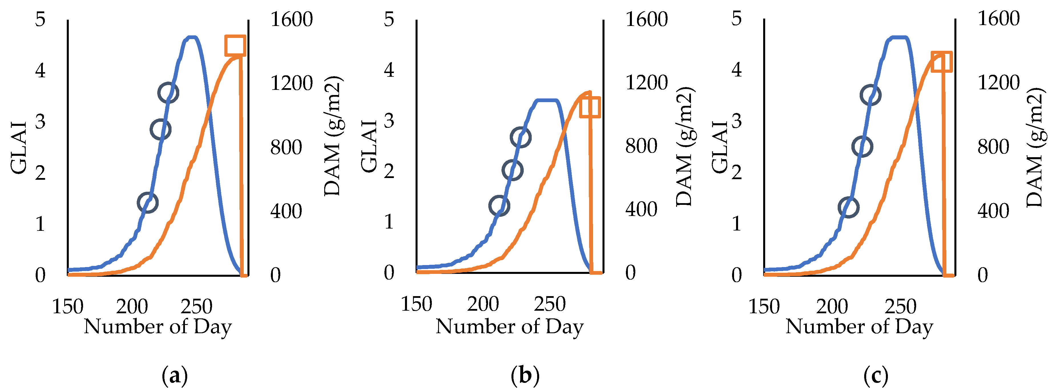

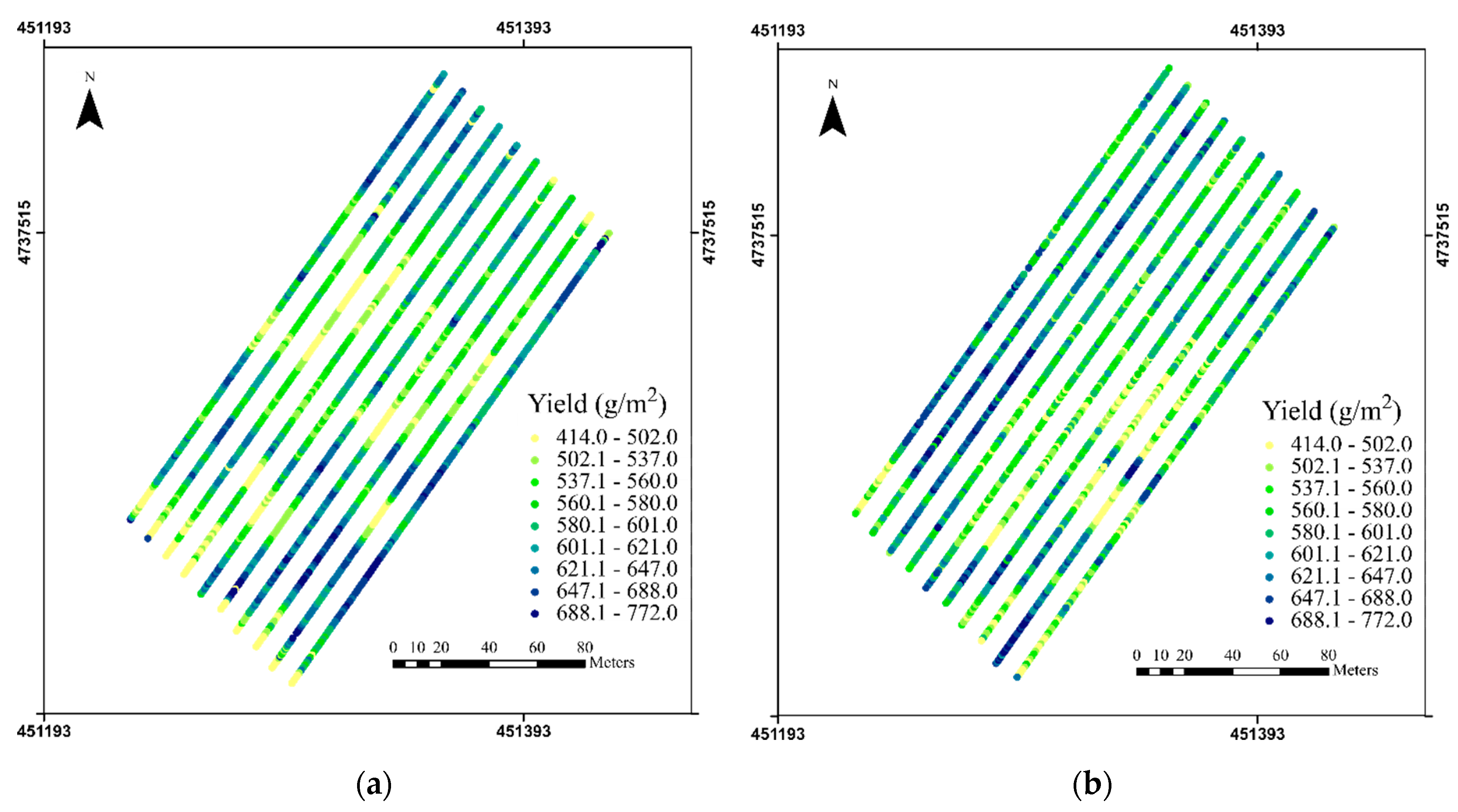
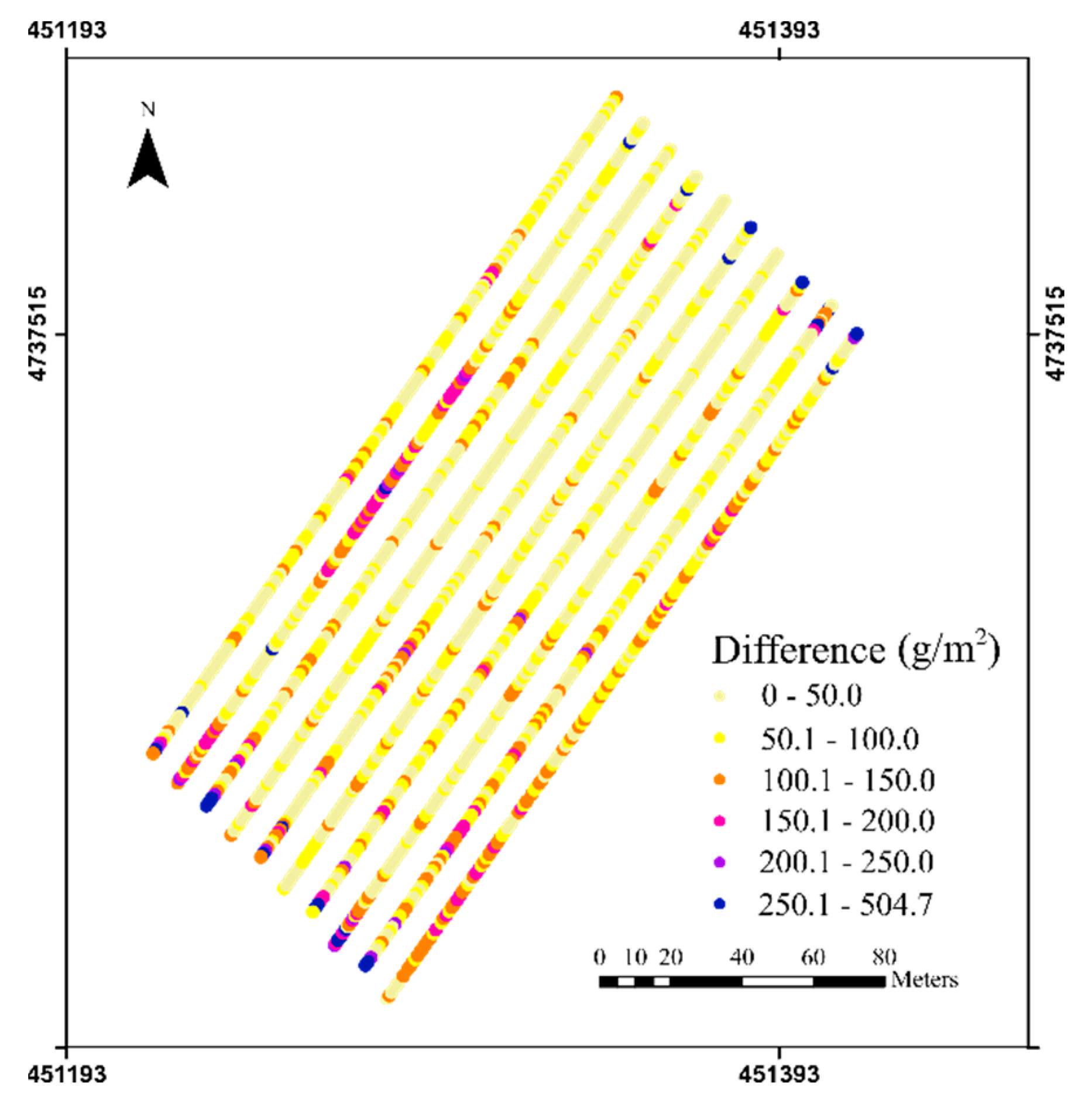
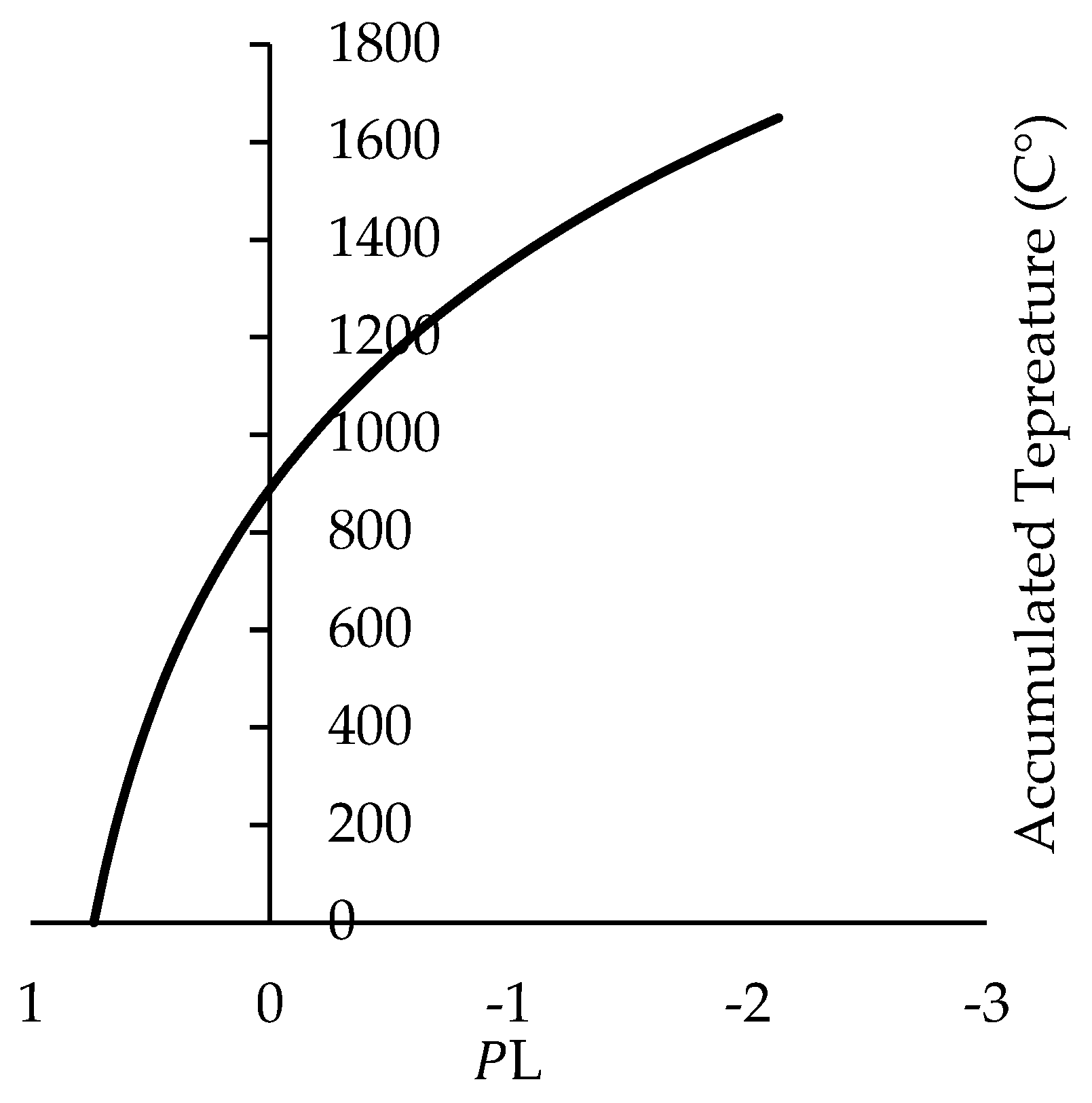

| Biomass (S1) | Biomass (S2) | Fisheye LAI (S1) | Fisheye LAI (S2) | UAV-Flights (S2) | BBCH | |
|---|---|---|---|---|---|---|
| 8-May | 12 samples | 12 samples | 20 | |||
| 11-May | 32 samples | 1257 images | 21 | |||
| 17-May | 12 samples | 12 samples | 32 samples | 25 | ||
| 21-May | 12 samples | 12 samples | 32 samples | 1157 images | 31 | |
| 27-May | 12 samples | 12 samples | 32 samples | 1157 images | 39 | |
| 3-June | 12 samples | 12 samples | 32 samples | 49 | ||
| 11-June | 12 samples | 12 samples | 32 samples | 65 | ||
| 16-June | 69 | |||||
| 20-July | 12 samples | 32 samples | 85 |
| Parameter name | Notation | Unit | Range | Value | Source |
|---|---|---|---|---|---|
| Climatic efficiency | - | 0.48 | [33,49,53] | ||
| Temperature range for winter wheat growth | , , | °C | [0,25,30] | [5,53] | |
| Specific leaf area | m2/g | 0.022 | [5] | ||
| Initial dry aboveground biomass | g/m2 | 4.2 | [5,34] | ||
| Light-extinction coefficient | - | 0.5 | [5,34] | ||
| Day of plant emergence | day | 64 | In-situ measurement | ||
| Day of senescence | day | 284 | In-situ measurement | ||
| Daily shortwave solar radiation | MJ/m2/d | In-situ measurement | |||
| Daily mean temperature | °C | In-situ measurement | |||
| Partition to leaf function: parameter a | - | 0.05–0.5 | First calibration | ||
| Partition to leaf function: parameter b | - | 10-5–10-2 | First calibration [5,34] | ||
| Sum of temperature for senescence | °C | 800–2000 | First calibration [5] | ||
| Rate of senescence | °C day | 0–105 | First calibration [49] | ||
| Effective light-use efficiency | g/MJ | 1.5–3.5 | Variable in this study Range [5,34] |
| ELUE (g/MJ) | |||||
|---|---|---|---|---|---|
| Maximum | 0.2686 | 0.00214 | 1084.10 | 4949.62 | 3.18 |
| Minimum | 0.2038 | 0.00151 | 848.401 | 2148.51 | 2.93 |
| Mean | 0.2377 | 0.00169 | 969.656 | 3543.41 | 3.08 |
| Median | 0.2424 | 0.00171 | 954.127 | 3449.86 | 3.08 |
| STD | 0.0229 | 0.00019 | 82.110 | 1023.33 | 0.085 |
| Mean (g/m2) | CV (%) | STD (g/m2) | RMSE (g/m2) | RRMSE (%) | |
|---|---|---|---|---|---|
| Harvester measured grain yield | 576.76 | 12.52 | 72.24 | 88 | 15.22 |
| Estimated yield | 578.62 | 8.77 | 50.77 |
© 2020 by the authors. Licensee MDPI, Basel, Switzerland. This article is an open access article distributed under the terms and conditions of the Creative Commons Attribution (CC BY) license (http://creativecommons.org/licenses/by/4.0/).
Share and Cite
Song, Y.; Wang, J.; Shang, J.; Liao, C. Using UAV-Based SOPC Derived LAI and SAFY Model for Biomass and Yield Estimation of Winter Wheat. Remote Sens. 2020, 12, 2378. https://doi.org/10.3390/rs12152378
Song Y, Wang J, Shang J, Liao C. Using UAV-Based SOPC Derived LAI and SAFY Model for Biomass and Yield Estimation of Winter Wheat. Remote Sensing. 2020; 12(15):2378. https://doi.org/10.3390/rs12152378
Chicago/Turabian StyleSong, Yang, Jinfei Wang, Jiali Shang, and Chunhua Liao. 2020. "Using UAV-Based SOPC Derived LAI and SAFY Model for Biomass and Yield Estimation of Winter Wheat" Remote Sensing 12, no. 15: 2378. https://doi.org/10.3390/rs12152378
APA StyleSong, Y., Wang, J., Shang, J., & Liao, C. (2020). Using UAV-Based SOPC Derived LAI and SAFY Model for Biomass and Yield Estimation of Winter Wheat. Remote Sensing, 12(15), 2378. https://doi.org/10.3390/rs12152378


