Retrieval of Daily Reference Evapotranspiration for Croplands in South Korea Using Machine Learning with Satellite Images and Numerical Weather Prediction Data


Abstract
:
1. Introduction
2. Data
2.1. Overview
2.2. In Situ Reference Evapotranspiration Data
2.3. Satellite Images
2.4. Numerical Weather Prediction Data
3. Methods
3.1. Spatial and Temporal Matchup
3.2. Random Forest and Its Extensions
3.3. Training and Blind Test
3.4. Comparison with Operative Product
4. Result and Discussion
4.1. Retrieval of Daily Reference Evapotranspiration
4.2. Spatial and Temporal Characteristics of the Accuracy Statistics
4.3. Agrometeorological Characteristics in Recent Years
5. Conclusions
Author Contributions
Funding
Acknowledgments
Conflicts of Interest
References
- Hamon, W.R. Estimating potential evapotranspiration. J. Hydraul. Div. 1961, 87, 107–120. [Google Scholar]
- Allen, R.G.; Pereira, L.S.; Raes, D.; Smith, M. Crop evapotranspiration—Guidelines for computing crop water requirements. In FAO Irrigation and Drainage Paper 56; FAO: Rome, Italy, 1998; Volume 300, p. D05109. [Google Scholar]
- Sumner, D.M. Evapotranspiration from a cypress and pine forest subjected to natural fires, Volusia County, Florida, 1998–1999. In Water-Resources Investigations Report 2001–4245; USGS: Reston, VA, USA, 2001. [Google Scholar]
- Thornthwaite, C.W. An approach toward a rational classification of climate. Geogr. Rev. 1948, 38, 55–94. [Google Scholar]
- Wilson, K.; Goldstein, A.; Falge, E.; Aubinet, M.; Baldocchi, D.; Berbigier, P.; Bernhofer, C.; Ceulemans, R.; Dolman, H.; Field, C.; et al. Energy balance closure at FLUXNET sites. Agric. For. Meteorol. 2002, 13, 223–243. [Google Scholar]
- Sumner, D.M.; Jacobs, J.M. Utility of Penman–Monteith, Priestley–Taylor, reference evapotranspiration, and pan evaporation methods to estimate pasture evapotranspiration. J. Hydrol. 2005, 308, 81–104. [Google Scholar]
- Kumar, A.; Bhatia, A.; Fagodiya, R.K.; Malyan, S.K.; Meena, B.L. Eddy covariance flux tower: A promising technique for greenhouse gases measurement. Adv. Plants Agric. Res. 2017, 7, 00263. [Google Scholar]
- McMahon, T.A.; Peel, M.C.; Lowe, L.; Srikanthan, R.; McVicar, T.R. Estimating actual, potential, reference crop and pan evaporation using standard meteorological data: A pragmatic synthesis. Hydrol. Earth Syst. Sci. 2013, 17, 1331–1363. [Google Scholar]
- Allen, R.G.; Tasumi, M.; Trezza, R. Satellite-based energy balance for mapping evapotranspiration with internalized calibration (METRIC)—Applications. J. Irrig. Drain. Eng. 2007, 133, 395–406. [Google Scholar]
- Mu, Q.; Heinsch, F.A.; Zhao, M.; Running, S.W. Development of a global evapotranspiration algorithm based on MODIS and global meteorology data. Remote Sens. Environ. 2007, 111, 519–536. [Google Scholar]
- Jang, K.; Kang, S.; Kim, H.; Kwon, H. Evaluation of shortwave irradiance and evapotranspiration derived from moderate resolution imaging spectroradiometer (MODIS). Asia Pac. J. Atmos. Sci. 2009, 45, 233–246. [Google Scholar]
- Zhang, K.; Kimball, J.S.; Nemani, R.R.; Running, S.W. A continuous satellite-derived global record of land surface evapotranspiration from 1983 to 2006. Water Resour. Res. 2010, 46. [Google Scholar] [CrossRef] [Green Version]
- Yuan, W.; Liu, S.; Yu, G.; Bonnefond, J.-M.; Chen, J.; Davis, K.; Desai, A.R.; Goldstein, A.H.; Gianelle, D.; Rossi, F.; et al. Global estimates of evapotranspiration and gross primary production based on MODIS and global meteorology data. Remote Sens. Environ. 2010, 114, 1416–1431. [Google Scholar]
- Bruin, H.A.R.; Trigo, I.F.; Jitan, M.A.; Enku, N.; der Tol, C.; Gieske, A.S.M. Reference crop evapotranspiration derived from geo-stationary satellite imagery: A case study for the Fogera flood plain, NW-Ethiopia and the Jordan Valley, Jordan. Hydrol. Earth Syst. Sci. 2010, 14, 2219–2228. [Google Scholar]
- Allen, R.; Irmak, A.; Trezza, R.; Hendrickx, J.M.; Bastiaanssen, W.; Kjaersgaard, J. Satellite-based ET estimation in agriculture using SEBAL and METRIC. Hydrol. Process. 2011, 25, 4011–4027. [Google Scholar]
- Irmak, A.; Ratcliffe, I.; Ranade, P.; Hubbard, K.G.; Singh, R.K.; Kamble, B.; Kjaersgaard, J. Estimation of land surface evapotranspiration with a satellite remote sensing procedure. Great Plains Res. 2011, 73–88. [Google Scholar]
- Mu, Q.; Zhao, M.; Running, S.W. Improvements to a MODIS global terrestrial evapotranspiration algorithm. Remote Sens. Environ. 2011, 115, 1781–1800. [Google Scholar]
- Shoemaker, W.B.; Sumner, D.M. Alternate corrections for estimating actual wetland evapotranspiration from potential evapotranspiration. Wetlands 2006, 26, 528–543. [Google Scholar]
- Anderson, M.C.; Norman, J.M.; Mecikalski, J.R.; Otkin, J.A.; Kustas, W.P. A climatological study of evapotranspiration and moisture stress across the continental United States based on thermal remote sensing: 2. Surface moisture climatology. J. Geophys. Res. Atmos. 2007, 112. [Google Scholar] [CrossRef]
- Fisher, J.B.; Tu, K.P.; Baldocchi, D.D. Global estimates of the land–atmosphere water flux based on monthly AVHRR and ISLSCP-II data, validated at 16 FLUXNET sites. Remote Sens. Environ. 2008, 112, 901–919. [Google Scholar]
- Kim, J.; Hogue, T.S. Evaluation of a MODIS-based potential evapotranspiration product at the point scale. J. Hydrometeorol. 2008, 9, 444–460. [Google Scholar]
- Anderson, M.C.; Kustas, W.P.; Norman, J.M.; Hain, C.R.; Mecikalski, J.R.; Schultz, L.; González-Dugo, M.P.; Cammalleri, C.; d’Urso, G.; Pimstein, A.; et al. Mapping daily evapotranspiration at field to continental scales using geostationary and polar orbiting satellite imagery. Hydrol. Earth Syst. Sci. 2011, 15, 223–239. [Google Scholar]
- Miralles, D.G.; Holmes, T.R.H.; De Jeu, R.A.M.; Gash, J.H.; Meesters, A.G.C.A.; Dolman, A.J. Global land-surface evaporation estimated from satellite-based observations. Hydrol. Earth Syst. Sci. 2011, 15, 453–469. [Google Scholar]
- Yao, Y.; Liang, S.; Cheng, J.; Liu, S.; Fisher, J.B.; Zhang, X.; Jia, K.; Zhao, X.; Qin, Q.; Zhao, B.; et al. MODIS-driven estimation of terrestrial latent heat flux in China based on a modified Priestley–Taylor algorithm. Agric. For. Meteorol. 2013, 171, 187–202. [Google Scholar]
- Yao, Y.; Liang, S.; Zhao, S.; Zhang, Y.; Qin, Q.; Cheng, J.; Jia, K.; Xie, X.; Zhang, N.; Liu, M. Validation and application of the modified satellite-based Priestley-Taylor algorithm for mapping terrestrial evapotranspiration. Remote Sens. 2014, 6, 880–904. [Google Scholar]
- Yao, Y.; Liang, S.; Li, X.; Chen, J.; Wang, K.; Jia, K.; Cheng, J.; Jiang, B.; Fisher, J.B.; Mu, Q.; et al. A satellite-based hybrid algorithm to determine the Priestley–Taylor parameter for global terrestrial latent heat flux estimation across multiple biomes. Remote Sens. Environ. 2015, 165, 216–233. [Google Scholar]
- Baik, J.; Choi, M. Evaluation of geostationary satellite (COMS) based Priestley–Taylor evapotranspiration. Agric. Water Manag. 2015, 159, 77–91. [Google Scholar]
- Semmens, K.A.; Anderson, M.C.; Kustas, W.P.; Gao, F.; Alfieri, J.G.; McKee, L.; Prueger, J.H.; Hain, C.R.; Cammalleri, C.; Yang, Y.; et al. Monitoring daily evapotranspiration over two California vineyards using Landsat 8 in a multi-sensor data fusion approach. Remote Sens. Environ. 2016, 185, 155–170. [Google Scholar]
- Jacobs, J.M.; Mergelsberg, S.L.; Lopera, A.F.; Myers, D.A. Evapotranspiration from a wet prairie wetland under drought conditions: Paynes prairie preserve, Florida, USA. Wetlands 2002, 22, 374–385. [Google Scholar]
- Wang, K.; Liang, S. An improved method for estimating global evapotranspiration based on satellite determination of surface net radiation, vegetation index, temperature, and soil moisture. J. Hydrometeorol. 2008, 9, 712–727. [Google Scholar]
- Wang, K.; Wang, P.; Li, Z.; Cribb, M.; Sparrow, M. A simple method to estimate actual evapotranspiration from a combination of net radiation, vegetation index, and temperature. J. Geophys. Res. Atmos. 2007, 112. [Google Scholar] [CrossRef]
- Papale, D.; Valentini, R. A new assessment of European forests carbon exchanges by eddy fluxes and artificial neural network spatialization. Glob. Chang. Biol. 2003, 9, 525–535. [Google Scholar]
- Yeom, J.M.; Lee, C.S.; Park, S.J.; Ryu, J.H.; Kim, J.J.; Kim, H.C.; Han, K.S. Evapotranspiration in Korea estimated by application of a neural network to satellite images. Remote Sens. Lett. 2015, 6, 429–438. [Google Scholar]
- Zhang, K.; Kimball, J.S.; Mu, Q.; Jones, L.A.; Goetz, S.J.; Running, S.W. Satellite based analysis of northern ET trends and associated changes in the regional water balance from 1983 to 2005. J. Hydrol. 2009, 379, 92–110. [Google Scholar]
- Yang, F.; White, M.A.; Michaelis, A.R.; Ichii, K.; Hashimoto, H.; Votava, P.; Nemani, R.R. Prediction of continental-scale evapotranspiration by combining MODIS and AmeriFlux data through support vector machine. IEEE Trans. Geosci. Remote Sens. 2006, 44, 3452–3461. [Google Scholar]
- Sulla-Menashe, D.; Friedl, M.A. User Guide to Collection 6 MODIS Land Cover (MCD12Q1 and MCD12C1) Product. Available online: https://lpdaac.usgs.gov/documents/101/MCD12_User_Guide_V6.pdf (accessed on 30 September 2020).
- Huffman, G.J.; Adler, R.F.; Bolvin, D.T.; Nelkin, E.J. The TRMM multi-satellite precipitation analysis (TMPA). In Satellite Rainfall Applications for Surface Hydrology; Springer: Dordrecht, The Netherlands, 2010; pp. 3–22. [Google Scholar]
- Zulkafli, Z.; Buytaert, W.; Onof, C.; Manz, B.; Tarnavsky, E.; Lavado, W.; Guyot, J.L. A comparative performance analysis of TRMM 3B42 (TMPA) versions 6 and 7 for hydrological applications over Andean–Amazon river basins. J. Hydrometeorol. 2014, 15, 581–592. [Google Scholar]
- Breiman, L. Random forests. Mach. Learn. 2001, 45, 5–32. [Google Scholar]
- Introduction to Boosted Trees. Available online: https://xgboost.readthedocs.io/en/latest/tutorials/model.html (accessed on 30 September 2020).
- Belgiu, M.; Drăguţ, L. Random forest in remote sensing: A review of applications and future directions. ISPRS J. Photogramm. Remote Sens. 2016, 114, 24–31. [Google Scholar]
- Kim, N.; Na, S.I.; Park, C.W.; Huh, M.; Oh, J.; Ha, K.J.; Cho, J.; Lee, Y.-W. An artificial intelligence approach to prediction of corn yields under extreme weather conditions using satellite and meteorological data. Appl. Sci. 2020, 10, 3785. [Google Scholar]
- MOD16A2GF v006. Available online: https://lpdaac.usgs.gov/products/mod16a2gfv006/ (accessed on 30 September 2020).
- Batra, N.; Islam, S.; Venturini, V.; Gisht, G.; Jiang, L.E. 2006 Estimation and comparison of evapotranspiration from MODIS and AVHRR sensors for clear sky days over the Southern Great Plains. Remote Sens. Environ. 2006, 103, 1–15. [Google Scholar]
- Wang, K.; Dickinson, R.E. A review of global terrestrial evapotranspiration: Observation, modeling, climatology, and climatic variability. Rev. Geophys. 2012, 50. [Google Scholar] [CrossRef]
- Sun, S.; Chen, H.; Wang, G.; Li, J.; Mu, M.; Yan, G.; Xu, B.; Huang, J.; Wang, J.; Zhang, F.; et al. Shift in potential evapotranspiration and its implications for dryness/wetness over Southwest China. J. Geophys. Res. Atmos. 2016, 121, 9342–9355. [Google Scholar]
- Jones, H.G. Plants and Microclimate: A Quantitative Approach to Environmental Plant Physiology, 2nd ed.; Cambridge University Press: Cambridge, UK, 1992. [Google Scholar]
- Hmimina, G.; Dufrêne, E.; Pontailler, J.Y.; Delpierre, N.; Aubinet, M.; Caquet, B.; de Grandcourt, A.; Burban, B.; Flechard, C.; Granier, A.; et al. Evaluation of the potential of MODIS satellite data to predict vegetation phenology in different biomes: An investigation using ground-based NDVI measurements. Remote Sens. Environ. 2013, 132, 145–158. [Google Scholar]
- Cai, Z.; Jonsson, P.; Jin, H.; Eklundh, L. Performance of smoothing methods for reconstructing NDVI time-series and estimating vegetation phenology from MODIS data. Remote Sens. 2017, 9, 1271. [Google Scholar]


| Data Source | Variable | Spatial Resolution | Temporal Resolution |
|---|---|---|---|
| MODIS 1 | NDVI 2 | 0.05° | 1 month |
| LAI 3 | 500 m | 8 days | |
| FPAR 4 | 500 m | 8 days | |
| GPM 5 | SPI3 6 | 0.25° | 1 day |
| LDAPS 7 | Air temperature | 1.5 km | 3 h |
| Land surface temperature | 1.5 km | 3 h | |
| Soil temperature | 1.5 km | 3 h | |
| Relative humidity | 1.5 km | 3 h | |
| Wind speed | 1.5 km | 3 h |
| Model | MBE | MAE | RMSE | CC 1 |
|---|---|---|---|---|
| Random forest (RF) | 0.007 | 0.790 | 1.038 | 0.870 |
| Gradient boosting machine (GBM) | 0.010 | 0.820 | 1.068 | 0.862 |
| Extreme gradient boosting (XGBoost) | 0.000 | 0.786 | 1.039 | 0.869 |
| Rank | Variable | PFI (%) 1 |
|---|---|---|
| 1 | Relative humidity | 33.170 |
| 2 | Land surface temperature | 25.052 |
| 3 | Air temperature | 11.932 |
| 4 | Soil temperature | 8.480 |
| 5 | SPI3 | 6.106 |
| 6 | NDVI | 4.487 |
| 7 | Wind speed | 4.243 |
| 8 | LAI | 3.516 |
| 9 | FPAR | 3.014 |
| Sum | 100 |
| Station No. | MBE | MAE | RMSE | CC 1 |
|---|---|---|---|---|
| 129 | 0.381 | 0.795 | 1.016 | 0.857 |
| 177 | −0.037 | 0.703 | 0.955 | 0.896 |
| 251 | 0.158 | 0.734 | 0.951 | 0.900 |
| 252 | −0.150 | 0.795 | 1.053 | 0.862 |
| 254 | −0.072 | 0.878 | 1.144 | 0.833 |
| 258 | 0.018 | 0.765 | 1.001 | 0.870 |
| 263 | 0.015 | 0.838 | 1.098 | 0.850 |
| 264 | −0.234 | 0.809 | 1.058 | 0.884 |
| 283 | −0.124 | 0.761 | 1.029 | 0.898 |
| Year | MBE | MAE | RMSE | CC 1 |
|---|---|---|---|---|
| 2013 | 0.143 | 0.789 | 1.021 | 0.870 |
| 2014 | −0.092 | 0.790 | 1.015 | 0.868 |
| 2015 | −0.017 | 0.834 | 1.092 | 0.893 |
| 2016 | 0.025 | 0.784 | 1.050 | 0.852 |
| 2017 | −0.034 | 0.813 | 1.071 | 0.856 |
| 2018 | −0.004 | 0.778 | 0.996 | 0.875 |
| 2019 | 0.030 | 0.745 | 1.015 | 0.873 |
| Month | Observed ET0 | Estimated ET0 | ||||
|---|---|---|---|---|---|---|
| Min (mm/day) | Max (mm/day) | Mean (mm/day) | Min (mm/day) | Max (mm/day) | Mean (mm/day) | |
| March | 0.494 | 8.555 | 3.572 | 0.840 | 7.582 | 3.600 |
| April | 0.599 | 9.621 | 4.493 | 0.826 | 8.395 | 4.479 |
| May | 0.771 | 11.087 | 5.933 | 1.001 | 9.640 | 5.674 |
| June | 0.698 | 10.145 | 5.124 | 1.299 | 8.437 | 5.013 |
| July | 0.570 | 10.852 | 4.492 | 1.001 | 8.325 | 4.442 |
| August | 0.476 | 9.243 | 4.576 | 1.022 | 7.827 | 4.749 |
| September | 0.264 | 8.183 | 3.786 | 0.868 | 6.881 | 3.907 |
| October | 0.584 | 6.679 | 3.109 | 1.000 | 6.517 | 3.208 |
| November | 0.384 | 5.615 | 2.257 | 0.673 | 4.934 | 2.351 |
| Month | MBE (mm/day) | MAE (mm/day) | RMSE (mm/day) | NRMSE 1 | CC 2 |
|---|---|---|---|---|---|
| March | 0.027 | 0.701 | 0.892 | 0.250 | 0.815 |
| April | −0.015 | 0.875 | 1.150 | 0.256 | 0.851 |
| May | −0.260 | 0.969 | 1.234 | 0.208 | 0.853 |
| June | −0.111 | 0.934 | 1.180 | 0.230 | 0.825 |
| July | −0.051 | 0.876 | 1.103 | 0.245 | 0.851 |
| August | 0.174 | 0.853 | 1.241 | 0.271 | 0.770 |
| September | 0.121 | 0.808 | 1.058 | 0.279 | 0.774 |
| October | 0.100 | 0.603 | 0.771 | 0.248 | 0.790 |
| November | 0.094 | 0.444 | 0.561 | 0.249 | 0.808 |
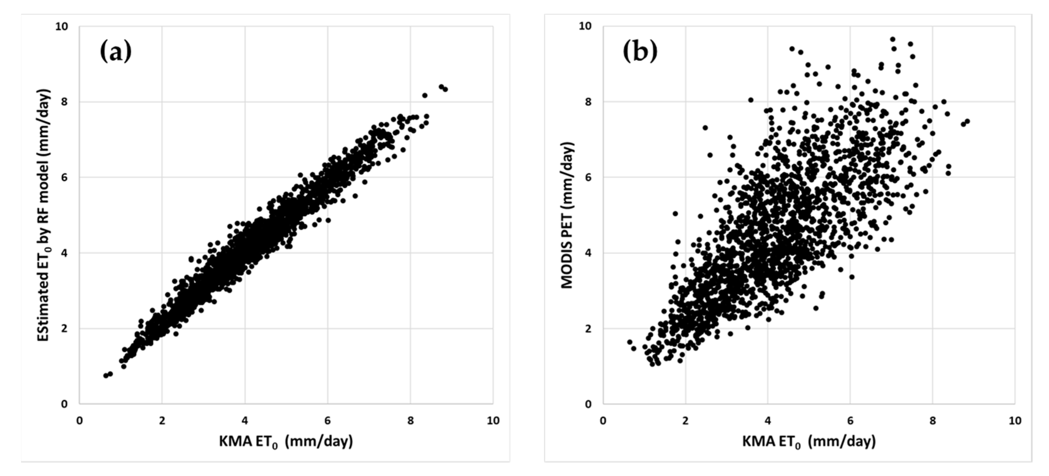
| Retrieval | MBE (mm/day) | MAE (mm/day) | RMSE (mm/day) | CC 1 | n |
|---|---|---|---|---|---|
| This study | −0.001 | 0.234 | 0.304 | 0.982 | 1883 |
| MODIS | 0.337 | 0.867 | 1.142 | 0.769 | 1883 |
Publisher’s Note: MDPI stays neutral with regard to jurisdictional claims in published maps and institutional affiliations. |
© 2020 by the authors. Licensee MDPI, Basel, Switzerland. This article is an open access article distributed under the terms and conditions of the Creative Commons Attribution (CC BY) license (http://creativecommons.org/licenses/by/4.0/).
Share and Cite
Kim, N.; Kim, K.; Lee, S.; Cho, J.; Lee, Y. Retrieval of Daily Reference Evapotranspiration for Croplands in South Korea Using Machine Learning with Satellite Images and Numerical Weather Prediction Data. Remote Sens. 2020, 12, 3642. https://doi.org/10.3390/rs12213642
Kim N, Kim K, Lee S, Cho J, Lee Y. Retrieval of Daily Reference Evapotranspiration for Croplands in South Korea Using Machine Learning with Satellite Images and Numerical Weather Prediction Data. Remote Sensing. 2020; 12(21):3642. https://doi.org/10.3390/rs12213642
Chicago/Turabian StyleKim, Nari, Kwangjin Kim, Soobong Lee, Jaeil Cho, and Yangwon Lee. 2020. "Retrieval of Daily Reference Evapotranspiration for Croplands in South Korea Using Machine Learning with Satellite Images and Numerical Weather Prediction Data" Remote Sensing 12, no. 21: 3642. https://doi.org/10.3390/rs12213642
APA StyleKim, N., Kim, K., Lee, S., Cho, J., & Lee, Y. (2020). Retrieval of Daily Reference Evapotranspiration for Croplands in South Korea Using Machine Learning with Satellite Images and Numerical Weather Prediction Data. Remote Sensing, 12(21), 3642. https://doi.org/10.3390/rs12213642