Review of Satellite Interferometry for Landslide Detection in Italy

 ,
,  ,
,  , ,
, ,  ,
,  and
and
Abstract

1. Introduction
2. Data Collection
- The title of the document;
- Region;
- Toponym and municipality (for small scale works, we focused on the province or region);
- First author;
- Affiliation of the first author;
- Year of publication;
- Digital object identifier (DOI), when available;
- Type of InSAR approach and algorithm;
- Satellite and band;
- Type of landslide monitored;
- Type of application. (We defined 5 classes: (1) back-analysis, (2) characterization, (3) landslide inventory update, (4) mapping, and (5) monitoring. An article can be assigned to multiple applications. A description of each class is given in Section 5.)
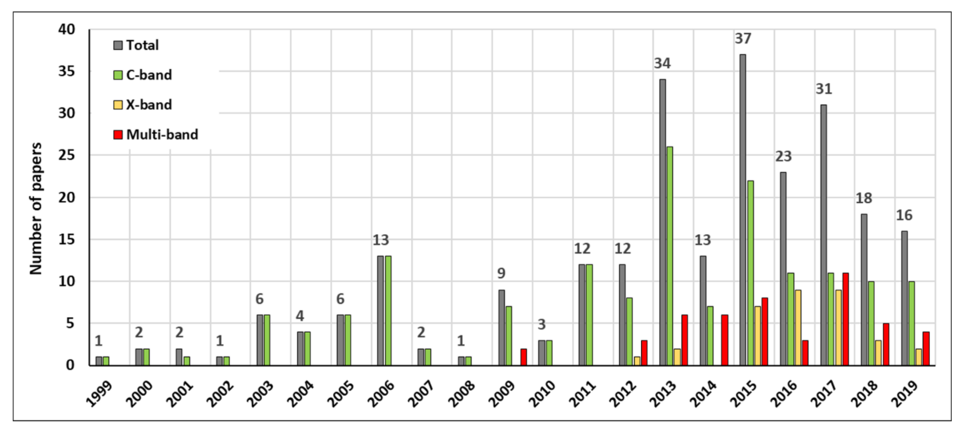
3. Temporal Evolution of the Scientific Production
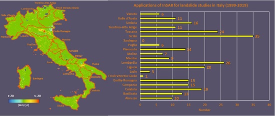
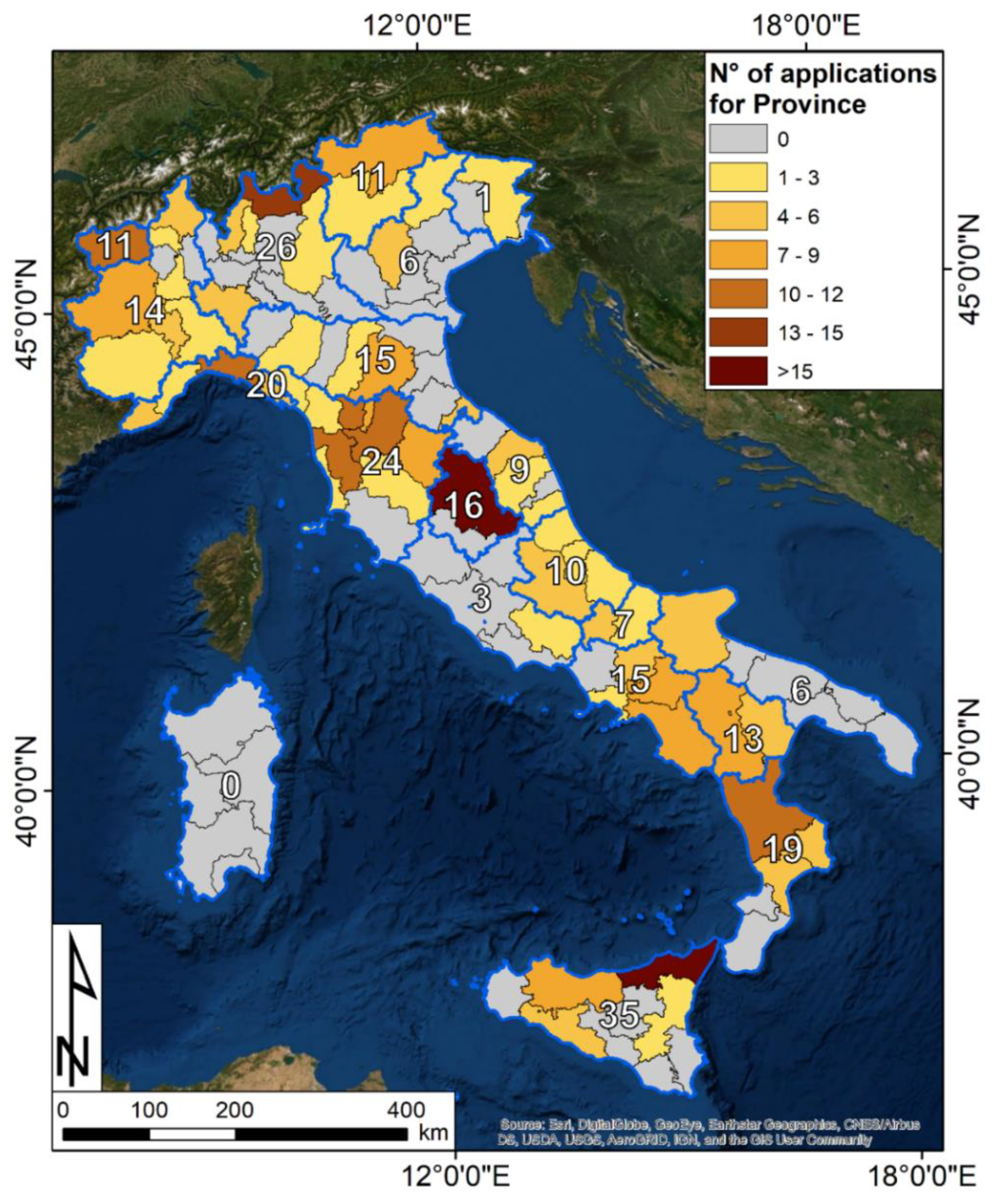
4. Spatial Distribution of the InSAR Applications
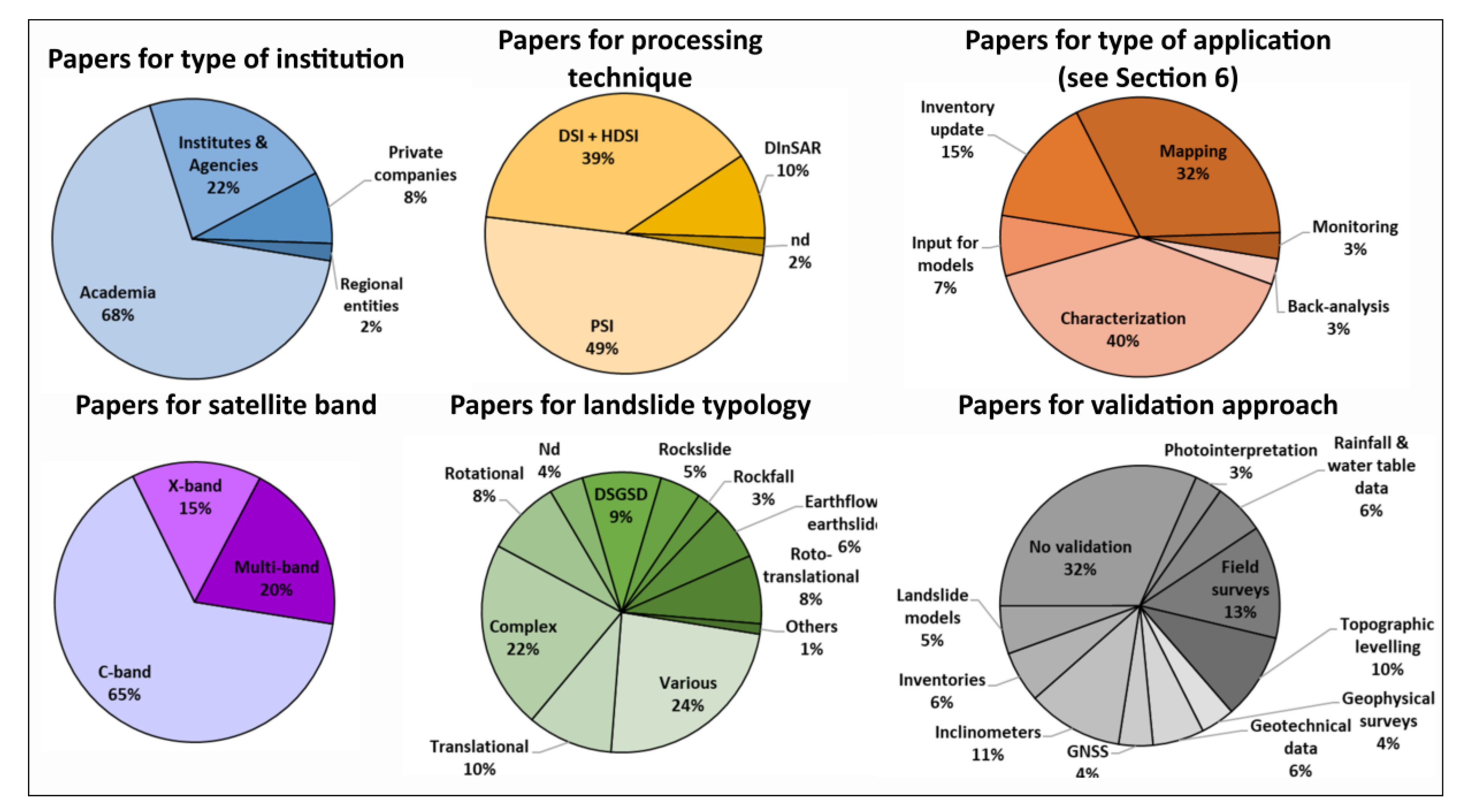
5. Statistical Evaluation of the Database
6. How InSAR Products Have Been Used for Landslide Studies in Italy
- Back-analysis: Satellite radar images are analyzed in response to the occurrence of a highly impactful and damaging landslide. InSAR is used to reconstruct the recent history and evolution of the landslide, as well as to investigate possible motion precursors before its catastrophic failure.
- Characterization: The activity focuses on a single landslide, where the classical geomorphological analysis, supported by ground survey evidence and in situ measurements, is integrated with interferometric results. Commonly, multi-band and multi-sensor data are used to cover the largest temporal span possible, reconstructing the evolution of the landslide. Such activity is mainly focused on the evaluation of the potential risk posed by the landslide, assessing its behavior and the possibility of a future failure.
- Input for models: Satellite evidence can become the input for different kind of models, depending on the working scale and on the landslide typology. For example, interferometric data can be used as inputs for landslide susceptibility refinement or for landslide model calibration and validation. This activity emphasizes the high interoperability of InSAR data with models and ancillary data in general.
- Landslide inventory update: One of the most useful features of InSAR products is the wide-area coverage coupled with millimeter accuracy. This potential is exploited for landslide inventory refinement, where landslide databases are available. This activity comprises the definition of the state of activity of known landslides, information to be used for urban planning, and risk management purposes, including the identification of stable areas for relocation [128];
- Mapping: This activity aimed to show what is moving in an area. Interferometric data are a valuable support to detect the motion of new and unknown landslides within the technical boundaries of the technique, in terms of maximum measurable displacement and considering the land coverage.
- Monitoring: The most advanced application of interferometric products, relying on a frequently updated processing plan. This activity is possible thanks to the low revisiting time of the most recent satellite constellations, such as Sentinel-1 (6 days) or COSMO-SkyMed (4–16 days). Satellite monitoring cannot be considered as a real-time product for obvious reasons, but, for some landslide types, a bi-weekly update frequency is enough to follow their evolution. Indeed, some authors refer to this activity as “near-real-time monitoring.”
6.1. Back-Analysis
6.2. Landslide Characterization
6.3. InSAR Data as Inputs for Models
6.4. Landslide Inventory Update and the State of Activity Definition
6.5. Landslide Mapping
6.6. Landslide Monitoring
7. Final Remarks
- The spatial sampling of measures. The density of measurement points over an area is uneven. Due to the dependency of radar coherence on the dielectric characteristics of the ground, vegetated, smooth and snow-covered surfaces have null to very low density of points. This is an unsolvable issue that can limit the number of landslides to be investigated, or the amount of information obtainable for a single phenomenon.
- The geometric effects. Foreshortening, layover, and shadowing are common geometric distortions in mountainous areas. Depending on the slope orientation with respect to the LOS of the sensor, some landslides could be detected, whereas others could not be in any case monitored. Thus, it is fundamental to know a priori whether our target landslides are measurable or not. The creation of a visibility map for the area of interest is a simple but effective way to estimate this before data processing [73,88].
- The one-dimensional nature of the results. InSAR provides the estimate of one component of the real displacement vector, i.e., along the LOS direction. This implies that the 3D motion of a landslide can be viewed from only one point of view. Since the kinematic of a landslide is complex, a good practice is to derive the vertical and the east-to-west horizontal components of motion from double geometry InSAR data [e.g., 96].
- The kinematic of the landslide. In a noise-free situation, the radar signal should not change by more than a quarter-wavelength (e.g., 14 mm for C-band sensors) between two consecutive samples. Due to noise, this threshold is in reality lower. Because of this, landslides characterized by non-linear deformation rates higher than 2 mm/day are challenging targets for InSAR. InSAR processing based on linear phase unwrapping would not be able to capture such motions. Higher order deformation models may be applied to solve the phase ambiguity for single applications [189].
- Landslide mapping over wide areas. As seen in Section 6.5, it is possible to retrieve reliable information about the presence of landslides over entire basins or regions. The analysis is limited to certain landslide types, i.e., extremely slow and very slow landslides, according to the Cruden & Varnes classification [191]. Moreover, the quality of the results depends on the land cover, the presence of snow or geometric effects. Nevertheless, InSAR is useful when no other ground or remotely sensed information is available or where it is impossible to gather them. In Italy, InSAR gave positive responses for landslide mapping in both Alpine and Apennine contexts.
- Landslide state of activity estimation. InSAR is becoming a reliable and recognized tool to assess the multi-temporal behavior of landslides, including the evaluation of their state of activity. This line of research is relevant for land planners since the presence of an active landslide forbids the construction of new structures. Landslide databases sometimes lack information about the current activity of landslides, limiting the correct management of a territory. InSAR is the right tool to provide such information and to be included in regional/national landslide-related policies. The Tuscany region is an example of this [152,164].
- Landslide characterization. One of the more powerful characteristics of InSAR is its multi-scale capability. With proper processing configurations and according to the satellite band, it can be profitably employed from the continental to the local scale. In the second case, it is the perfect complement for in situ motion instruments and for use as input for landslide models.
- Back-analysis. Nowadays, an InSAR database can cover a 28-year time span with different satellite images acquired by multi-band sensors. This is a relevant feature for the post-collapse reconstruction of the landslide behavior.
8. Future Perspectives
- The increase of repeat pass time offered by the latest radar constellations allows and will allow for a better temporal definition of the landslide behavior over time. This opens new lines of research for time series data mining algorithms, and for the back-analysis of landslide events. The latter activity is certainly aided by the capability to construct 28-year-long time series. Moreover, some authors have already exploited InSAR as a calibration tool for landslide models, and we expect that, with a larger diffusion of such data, this activity will increase in the future.
- The increasing diffusion of InSAR products over wide areas will stimulate the integration of radar and optical results for the improvements of available landslide inventories. Moreover, the all-weather acquisition of radar satellites can be exploited to map landslides connected to a specific event in the areas of the world where cloud coverage is a recurrent issue. The future launch of the Radar Observing System for Europe L (ROSE-L) constellation by the European Space Agency will certainly offer new capabilities for landslide mapping and for InSAR analysis in general [193].
- The wide area capability and the level of accuracy of InSAR results have allowed some scientists to develop integrated approaches for qualitative and quantitative landslide risk assessment. In our opinion, this line of research has much room for improvement. Moreover, it is expected that InSAR will be integrated in civil protection practices and in landslide risk management chains.
- The Sentinel-1 constellation opened new horizons for landslide studies, allowing for the development of near-real-time monitoring systems, as testified by the example of the Tuscany region [187]. Such applications encourage a different use of InSAR data, trying to forecast rather than back-analyze or map landslides. On the one hand, these approaches surely carry a great potential for landslide risk management and civil protection activities. On the other hand, this data requires the continuous control of InSAR experts; such activity produces complex outputs that need to be interpreted before being disseminated to stakeholders. Moreover, as intrinsic for a novel near-real-time tool, the number of false positives is not negligible, and should be taken into account with proper data management and dissemination strategies.
- Italy is collecting user requirements for the future national ground motion service (GMS) based on Sentinel-1 and COSMO-SkyMed PSI and DSI products. The project is designed as the Mirror Copernicus Downstream Service and is one of the expected products of the Italian Space Economy Strategic Plan [194]. This service follows the examples of previously launched GMSs, such as InSAR Norway [195] and the German Ground Motion Service [196]. Such services are of pivotal importance for landslide mapping activities at a national and regional scale. Moreover, the GMSs are currently used and will continue to be used by researchers, public entities, and private companies to assess the status of known and unknown landslides. Depending on the temporal update of the data and on the target phenomenon, the services could be used for landslide mapping or monitoring activities.
- In 2017, the Copernicus User Forum and the Copernicus Committee unanimously approved the addition of the European Ground Motion Survey (EGMS) to the Copernicus Land Monitoring Service’ product portfolio [197]. The idea of the EGMS started in November 2016, when the EGMS Task Force began to develop the EGMS White Paper [198], which is considered the conceptual framework for the current project. Over the next few years, the EGMS will deliver consistent, regular, standardized, harmonized, and reliable information regarding natural and anthropogenic ground motion phenomena (including landslides) over Europe. Considering the successful experiences and the frequency of impactful landslide events, such service will constitute a reliable baseline for landslide studies, hopefully guaranteeing a wider uptake of satellite interferometric data.
- Despite the maturity of the interferometric techniques, the repeat pass time is still a major hurdle for the use of satellite InSAR as tool for systematic monitoring, especially when dealing with very short period events, such as landslide accelerations. Geological processes with strong deformation magnitudes with respect to the temporal sampling may yield aliased results or be missed altogether. In this scenario, another promising opportunity is represented by geosynchronous satellite, whose observing capability can provide a novel set of measurements, specifically InSAR at high temporal resolution (e.g., 1–12 h). This can be a game changer for solid earth applications. Hydroterra is an example of a project exploring such new InSAR horizons [199]. Hydroterra is currently a phase 0 candidate mission for the 10th Earth Explorer Programme of the ESA. The aim of the project is to observe key processes of the daily water cycle by placing a single SAR satellite in geosynchronous orbit. The Mediterranean, the Alpine Arc, Sahel, and other African regions would be covered from a geosynchronous orbit slot positioned over Africa. The main science goals are to improve the prediction capability of intense rainfall and related flooding and landslides, improving the understanding of the diurnal water cycle. These goals will be supported by providing estimates of soil moisture, integrated atmospheric water vapor changes, flood extent, and information on snow melt. Secondarily, rapid response imaging of ground motion will enable new science applications and near-real-time services.
Supplementary Materials
Author Contributions
Funding
Conflicts of Interest
References
- Brunetti, M.T.; Peruccacci, S.; Rossi, M.; Luciani, S.; Valigi, D.; Guzzetti, F. Rainfall thresholds for the possible occurrence of landslides in Italy. Nat. Hazards Earth Syst. Sci. 2010, 10, 447–458. [Google Scholar] [CrossRef]
- Trigila, A.; Iadanza, C.; Spizzichino, D. Quality assessment of the Italian Landslide Inventory using GIS processing. Landslides 2010, 7, 455–470. [Google Scholar] [CrossRef]
- Salvati, P.; Bianchi, C.; Rossi, M.; Guzzetti, F. Societal landslide and flood risk in Italy. Nat. Hazards Earth Syst. Sci. 2010, 10, 465–483. [Google Scholar] [CrossRef]
- Barla, G.; Paronuzzi, P. The 1963 Vajont Landslide: 50th Anniversary. Rock Mech. Rock Eng. 2013, 46, 1267. [Google Scholar] [CrossRef]
- Crosta, G.B.; Chen, H.; Lee, C.F. Replay of the 1987 Val Pola landslide, Italian alps. Geomorphology 2004, 60, 127–146. [Google Scholar] [CrossRef]
- Crosta, G.B.; Dal Negro, P. Observations and modelling of soil slip-debris flow initiation processes in pyroclastic deposits: The Sarno 1998 event. Nat. Hazards Earth Syst. Sci. 2003, 3, 53–69. [Google Scholar] [CrossRef]
- Guzzetti, F. Landslide fatalities and the evaluation of landslide risk in Italy. Eng. Geol. 2000, 58, 89–107. [Google Scholar] [CrossRef]
- Chae, B.G.; Park, H.J.; Catani, F.; Simoni, A.; Berti, M. Landslide prediction, monitoring and early warning: A concise review of state-of-the-art. Geosci. J. 2017, 21, 1033–1070. [Google Scholar] [CrossRef]
- Crosetto, M.; Monserrat, O.; Cuevas-González, M.; Devanthéry, N.; Crippa, B. Persistent scatterer interferometry: A review. ISPRS J. Photogramm. Remote Sens. 2016, 115, 78–89. [Google Scholar] [CrossRef]
- Ferretti, A.; Prati, C.; Rocca, F. Permanent scatterers in SAR interferometry. IEEE Trans. Geosci. Remote Sens. 2001, 39, 8–20. [Google Scholar] [CrossRef]
- Berardino, P.; Fornaro, G.; Lanari, R.; Sansosti, E. A new algorithm for surface deformation monitoring based on small baseline differential SAR interferograms. IEEE Trans. Geosci. Remote Sens. 2002, 40, 2375–2383. [Google Scholar] [CrossRef]
- Delacourt, C.; Allemand, P.; Berthier, E.; Raucoules, D.; Casson, B.; Grandjean, P.; Pambrun, C.; Varel, E. Remote-sensing techniques for analysing landslide kinematics: A review. Bull. Soc. Geol. Fr. 2007, 178, 89–100. [Google Scholar] [CrossRef]
- Zhou, X.; Chang, N.B.; Li, S. Applications of SAR interferometry in earth and environmental science research. Sensors 2009, 9, 1876–1912. [Google Scholar] [CrossRef] [PubMed]
- Pepe, A.; Calò, F. A review of interferometric synthetic aperture RADAR (InSAR) multi-track approaches for the retrieval of Earth’s surface displacements. Appl. Sci. 2017, 7, 1264. [Google Scholar] [CrossRef]
- Mantovani, F.; Soeters, R.; Van Westen, C.J. Remote sensing techniques for landslide studies and hazard zonation in Europe. Geomorphology 1996, 15, 213–225. [Google Scholar] [CrossRef]
- Metternicht, G.; Hurni, L.; Gogu, R. Remote sensing of landslides: An analysis of the potential contribution to geo-spatial systems for hazard assessment in mountainous environments. Remote Sens. Environ. 2005, 98, 284–303. [Google Scholar] [CrossRef]
- Scaioni, M.; Longoni, L.; Melillo, V.; Papini, M. Remote sensing for landslide investigations: An overview of recent achievements and perspectives. Remote Sens. 2014, 6, 9600–9652. [Google Scholar] [CrossRef]
- Tofani, V.; Segoni, S.; Agostini, A.; Catani, F.; Casagli, N. Use of remote sensing for landslide studies in Europe. Nat. Hazards Earth Syst. Sci. 2013, 13, 299–309. [Google Scholar] [CrossRef]
- Wasowski, J.; Bovenga, F. Investigating landslides and unstable slopes with satellite Multi Temporal Interferometry: Current issues and future perspectives. Eng. Geol. 2014, 174, 103–138. [Google Scholar] [CrossRef]
- Rucci, A.; Ferretti, A.; Guarnieri, A.M.; Rocca, F. Sentinel 1 SAR interferometry applications: The outlook for sub millimeter measurements. Remote Sens. Environ. 2012, 120, 156–163. [Google Scholar] [CrossRef]
- Herrera, G.; Mateos, R.M.; García-Davalillo, J.C.; Grandjean, G.; Poyiadji, E.; Maftei, R.; Filipciuc, T.-C.; Auflič, M.J.; Jež, J.; Podolszki, L. Landslide databases in the Geological Surveys of Europe. Landslides 2018, 15, 359–379. [Google Scholar] [CrossRef]
- Haque, U.; Blum, P.; Da Silva, P.F.; Andersen, P.; Pilz, J.; Chalov, S.R.; Malet, J.-P.; Auflič, N.J.; Andres, N.; Poyiadji, E.; et al. Fatal landslides in Europe. Landslides 2016, 13, 1545–1554. [Google Scholar] [CrossRef]
- Martín-Martí, A.; Orduna-Malea, E.; Thelwall, M.; López-Cózar, E.D. Google Scholar, Web of Science, and Scopus: A systematic comparison of citations in 252 subject categories. J. Informetr. 2018, 12, 1160–1177. [Google Scholar] [CrossRef]
- Halevi, G.; Moed, H.; Bar-Ilan, J. Suitability of Google Scholar as a source of scientific information and as a source of data for scientific evaluation—Review of the literature. J. Informetr. 2017, 11, 823–834. [Google Scholar] [CrossRef]
- Ferretti, A.; Prati, C.; Rocca, F. Permanent scatterers in SAR interferometry. In Proceedings of the IEEE 1999 International Geoscience and Remote Sensing Symposium, Hamburg, Germany, 28 June–2 July 1999; Stein, T.I., Ed.; IEEE Publications: Piscataway, NJ, USA, 1999. [Google Scholar]
- Agostini, A.; Tofani, V.; Nolesini, T.; Gigli, G.; Tanteri, L.; Rosi, A.; Cardellini, S.; Casagli, N. A new appraisal of the Ancona landslide based on geotechnical investigations and stability modelling. Q. J. Eng. Geol. Hydrogeol. 2014, 47, 29–43. [Google Scholar] [CrossRef]
- Nitti, D.O.; Bovenga, F.; Nutricato, R.; Rana, F.; D’Aprile, C.; Frattini, P.; Crosta, G.B.; Chiaradia, M.T.; Ober, G.; Candela, L. C- and X-band Multi-pass InSAR analysis over alpine areas (ITALY). In Image and Signal Processing for Remote Sensing XV, Proceeding of SPIE Remote Sensing, Berlin, Germany, 31 August–3 September 2019; Bruzzone, L., Notarnicola, C., Posa, F., Eds.; International Society for Optics and Photonics: Bellingham, WA, USA, 2019. [Google Scholar]
- Bovenga, F.; Nutricato, R.; Guerriero, A.R.L.; Chiaradia, M.T. SPINUA: A flexible processing chain for ERS/ENVISAT long term interferometry. In Proceedings of the ESA-ENVISAT Symposium, Salzburg, Austria, 6–10 September 2004; Lacoste, H., Ouwehand, L., Eds.; ESA Publications Division: Noordwijk, The Netherlands, 2004. [Google Scholar]
- Zinno, I.; Bonano, M.; Buonanno, S.; Casu, F.; De Luca, C.; Manunta, M.; Manzo, M.; Lanari, R. National Scale Surface Deformation Time Series Generation through Advanced DInSAR Processing of Sentinel-1 Data within a Cloud Computing Environment. IEEE Trans. Big Data 2018, 1, 1–17. [Google Scholar] [CrossRef]
- Costantini, M.; Ferretti, A.; Minati, F.; Falco, S.; Trillo, F.; Colombo, D.; Novali, F.; Malvarosa, F.; Mammone, C.; Vecchioli, F.; et al. Analysis of surface deformations over the whole Italian territory by interferometric processing of ERS, Envisat and COSMO-SkyMed radar data. Remote Sens. Environ. 2017, 202, 250–275. [Google Scholar] [CrossRef]
- Colombo, D.; Farina, P.; Gontier, E.; Fumagalli, A.; Moretti, S. Integration of Permanent Scatterers analysis and high resolution optical images within landslide risk analysis. In Proceedings of the FRINGE 2003 Workshop, Advances in SAR interferometry from ERS and ENVISAT missions, Frascati, Italy, 20 August 2003; ESA Publications Division: Noordwijk, The Netherlands, 2003. [Google Scholar]
- Farina, P.; Moretti, S.; Colombo, D.; Fumagalli, A.; Manunta, P. Landslide risk analysis by means of remote sensing techniques: Results from the ESA/SLAM project. In Proceedings of the International Geoscience and Remote Sensing Symposium IGARSS 2004, Anchorage, AK, USA, 20–24 September 2004; IEEE: Piscataway, NJ, USA, 2004. [Google Scholar]
- Farina, P.; Colombo, D.; Fumagalli, A.; Marks, F.; Moretti, S. Permanent Scatterers for landslide investigations: Outcomes from the ESA-SLAM project. Eng. Geol. 2006, 88, 200–217. [Google Scholar] [CrossRef]
- Canuti, P.; Casagli, N.; Catani, F.; Falorni, G.; Farina, P. Integration of remote sensing techniques in different stages of landslide response. In Progress in Landslide Science; Sassa, K., Fukuoka, H., Wang, F., Wang, G., Eds.; Springer: Berlin/Heidelberg, Germany, 2007; pp. 251–260. [Google Scholar]
- Lu, P.; Casagli, N.; Catani, F.; Tofani, V. Persistent Scatterers Interferometry Hotspot and Cluster Analysis (PSI-HCA) for detection of extremely slow-moving landslides. Int. J. Remote Sens. 2012, 33, 466–489. [Google Scholar] [CrossRef]
- Brugioni, M.; Mazzanti, B.; Montini, G.; Sulli, L. Use of SAR interferometry for landslide analysis in the Arno river basin. In Landslide Science and Practice; Margottini, C., Canuti, P., Sassa, K., Eds.; Springer: Berlin/Heidelberg, Germany, 2013; pp. 203–210. [Google Scholar]
- Lu, P.; Daehne, A.; Travelletti, J.; Casagli, N.; Corsini, A.; Malet, J.P. Innovative techniques for the detection and characterization of the kinematics of slow-moving landslides. In Mountain Risks: From Prediction to Management and Governance; Van Asch, T., Corominas, J., Greiving, S., Malet, J.-P., Sterlacchini, S., Eds.; Springer: Dordrecht, The Netherlands, 2014; pp. 31–56. [Google Scholar]
- Del Ventisette, C.; Gigli, G.; Tofani, V.; Lu, P.; Casagli, N. Radar technologies for landslide detection, monitoring, early warning and emergency management. In Modern Technologies for Landslide Monitoring and Prediction; Scaioni, M., Ed.; Springer: Berlin, Germany, 2015; pp. 209–232. [Google Scholar]
- Raspini, F.; Moretti, S.; Casagli, N. Landslide mapping using SqueeSAR data: Giampilieri (Italy) case study. In Landslide Science and Practice; Margottini, C., Canuti, P., Sassa, K., Eds.; Springer: Berlin/Heidelberg, Germany, 2013; pp. 147–154. [Google Scholar]
- Ciampalini, A.; Raspini, F.; Frodella, W.; Bardi, F.; Bianchini, S.; Moretti, S. The effectiveness of high-resolution LiDAR data combined with PSInSAR data in landslide study. Landslides 2016, 13, 399–410. [Google Scholar] [CrossRef]
- Casagli, N.; Tofani, V.; Ciampalini, A.; Raspini, F.; Lu, P.; Morelli, S. TXT-tool 2.039-3.1: Satellite Remote Sensing Techniques for Landslides Detection and Mapping. In Landslide Dynamics: ISDR-ICL Landslide Interactive Teaching Tools; Sassa, K., Guzzetti, F., Yamagishi, H., Arbanas, Ž., Casagli, N., McSaveney, M., Dang, K., Eds.; Springer: Cham, Switzerland, 2017; pp. 235–254. [Google Scholar]
- Del Ventisette, C.; Ciampalini, A.; Manunta, M.; Calò, F.; Paglia, L.; Ardizzone, F.; Mondini, A.C.; Reichenbach, P.; Mateos, R.M.; Bianchini, S.; et al. Exploitation of large archives of ERS and ENVISAT C-band SAR data to characterize ground deformations. Remote Sens. 2013, 5, 3896–3917. [Google Scholar] [CrossRef]
- Bardi, F.; Frodella, W.; Ciampalini, A.; Bianchini, S.; Del Ventisette, C.; Gigli, G.; Fanti, R.; Moretti, S.; Basile, G.; Casagli, N. Integration between ground based and satellite SAR data in landslide mapping: The San Fratello case study. Geomorphology 2014, 223, 45–60. [Google Scholar] [CrossRef]
- Bianchini, S.; Tapete, D.; Ciampalini, A.; Di Traglia, F.; Del Ventisette, C.; Moretti, S.; Casagli, N. Multi-temporal evaluation of landslide-induced movements and damage assessment in San Fratello (Italy) by means of C-and X-band PSI data. In Mathematics of Planet Earth; Golden, K., Lewis, M., Nishiura, Y., Tribbia, J., Zubelli, J.P., Eds.; Springer: Berlin, Germany, 2013; pp. 257–261. [Google Scholar]
- Ciampalini, A.; Bardi, F.; Bianchini, S.; Frodella, W.; Del Ventisette, C.; Moretti, S.; Casagli, N. Analysis of building deformation in landslide area using multisensor PSInSAR™ technique. Int. J. Appl. Earth Obs. 2014, 33, 166–180. [Google Scholar] [CrossRef] [PubMed]
- Bianchini, S.; Ciampalini, A.; Raspini, F.; Bardi, F.; Di Traglia, F.; Moretti, S.; Casagli, N. Multi-temporal evaluation of landslide movements and impacts on buildings in San Fratello (Italy) by means of C-band and X-band PSI data. Pure Appl. Geophys. 2015, 172, 3043–3065. [Google Scholar] [CrossRef]
- Calò, F. DORIS project: The European downstream service for landslides and subsidence risk management. In Proceedings of the 2012 IEEE International Geoscience and Remote Sensing Symposium, Munich, Germany, 22–27 July 2012; IEEE: Piscataway, NJ, USA, 2012; pp. 3018–3021. [Google Scholar]
- Ciampalini, A.; Raspini, F.; Moretti, S. Landslide back monitoring and forecasting by using PSInSAR technique: The case of Naso (Sicily, Southern Italy). Atti Soc. Tosc. Sci. Nat. Mem. Ser. A 2015, 122. [Google Scholar] [CrossRef]
- Ciampalini, A.; Raspini, F.; Bianchini, S.; Frodella, W.; Bardi, F.; Lagomarsino, D.; Di Traglia, F.; Moretti, S.; Proietti, C.; Pagliara, P.; et al. Remote sensing as tool for development of landslide databases: The case of the Messina Province (Italy) geodatabase. Geomorphology 2015, 249, 103–118. [Google Scholar] [CrossRef]
- Ciampalini, A.; Raspini, F.; Lagomarsino, D.; Catani, F.; Casagli, N. Landslide susceptibility map refinement using PSInSAR data. Remote Sens. Environ. 2016, 184, 302–315. [Google Scholar] [CrossRef]
- Raspini, F.; Ciampalini, A.; Bianchini, S.; Bardi, F.; Di Traglia, F.; Basile, G.; Moretti, S. Updated landslide inventory of the area between the Furiano and Rosmarino creeks (Sicily, Italy). J. Maps 2016, 12, 1010–1019. [Google Scholar] [CrossRef]
- Ciampalini, A.; Raspini, F.; Lagomarsino, D.; Catani, F.; Casagli, N. How to improve the accuracy of landslide susceptibility maps using PSInSAR data. In Proceedings of the Workshop on World Landslide Forum, Ljubljana, Slovenia, 29 May–2 June 2017; Springer: Cham, Switzerland, 2017; pp. 965–971. [Google Scholar]
- Guzzetti, F.; Manunta, M.; Ardizzone, F.; Pepe, A.; Cardinali, M.; Zeni, G.; Reichenbach, P.; Lanari, R. Analysis of ground deformation detected using the SBAS-DInSAR technique in Umbria, Central Italy. Pure Appl. Geophys. 2009, 166, 1425–1459. [Google Scholar] [CrossRef]
- Radicioni, F.; Stoppini, A.; Brigante, R.; Fornaro, G.; Bovenga, F.; Nitti, D.O. Long-term GNSS and SAR data comparison for the deformation monitoring of the Assisi landslide. In Proceedings of the FIG Working Week 2012, Knowing to Manage the Territory, Protect the Environment, Evaluate the Cultural Heritage, Rome, Italy, 6–10 May 2012; pp. 6–10. [Google Scholar]
- Bonano, M.; Calo, F.; Manunta, M.; Paglia, L.; Zeni, G. Long-term Analysis of Landslides via SBAS-DInSAR. In Landslide Science and Practice: Volume 2: Early Warning, Instrumentation and Monitoring; Springer: Berlin/Heidelberg, Germany, 2013; p. 141. [Google Scholar]
- Bovenga, F.; Nitti, D.O.; Fornaro, G.; Radicioni, F.; Stoppini, A.; Brigante, R. Using C/X-band SAR interferometry and GNSS measurements for the Assisi landslide analysis. Int. J. Remote Sens. 2013, 34, 4083–4104. [Google Scholar] [CrossRef]
- Calò, F.; Ardizzone, F.; Castaldo, R.; Lollino, P.; Tizzani, P.; Guzzetti, F.; Lanari, R.; Angeli, M.G.; Pontoni, F.; Manunta, M. Enhanced landslide investigations through advanced DInSAR techniques: The Ivancich case study, Assisi, Italy. Remote Sens. Environ. 2014, 142, 69–82. [Google Scholar] [CrossRef]
- Castaldo, R.; Tizzani, P.; Lollino, P.; Calò, F.; Ardizzone, F.; Lanari, R.; Guzzetti, F.; Manunta, M. Landslide kinematical analysis through inverse numerical modelling and differential SAR interferometry. Pure Appl. Geophys. 2015, 172, 3067–3080. [Google Scholar] [CrossRef]
- Castaldo, R.; Tizzani, P.; Lollino, P.; Calò, F.; Ardizzone, F.; Manunta, M.; Guzzetti, F.; Lanari, R. The Ivancich active landslide process (Assisi, Central Italy) analysed via numerical modeling jointly optimized by DInSAR and inclinometric data. In Engineering Geology for Society and Territory-Volume 2; Springer: Cham, Switzerland, 2015; pp. 1513–1517. [Google Scholar]
- De Novellis, V.; Castaldo, R.; Lollino, P.; Manunta, M.; Tizzani, P. Advanced three-dimensional finite element modeling of a slow landslide through the exploitation of dinsar measurements and in situ surveys. Remote Sens. 2016, 8, 670. [Google Scholar] [CrossRef]
- Colesanti, C.; Crosta, G.B.; Ferretti, A.; Ambrosi, C. Monitoring and assessing the state of activity of slope instabilities by the Permanent Scatterers Technique. In Landslides from Massive Rock Slope Failure; Evans, S.G., Scarascia Mugnozza, G., Strom, A., Hermanns, R.L., Eds.; Springer: Dordrecht, The Netherlands, 2006; pp. 175–194. [Google Scholar]
- Frattini, P.; Crosta, G.; Allievi, J. Damage to buildings in large slope rock instabilities monitored with the PSInSAR™ technique. Remote Sens. 2013, 5, 4753–4773. [Google Scholar] [CrossRef]
- Agliardi, F.; Crosta, G.B. Long-and short-term controls on the Spriana rockslide (Central Alps, Italy). In Landslide Science for a Safer Geoenvironment; Sassa, K., Canuti, P., Yin, Y., Eds.; Springer: Cham, Switzerland, 2014; pp. 243–249. [Google Scholar]
- Del Ventisette, C.; Righini, G.; Moretti, S.; Casagli, N. Multitemporal landslides inventory map updating using spaceborne SAR analysis. Int. J. Appl. Earth Obs. 2014, 30, 238–246. [Google Scholar] [CrossRef]
- Tamburini, A.; Del Conte, S.; Novali, F.; Frattini, P.; Crosta, G.B. Recent advances in satellite radar data processing and their support to the characterization of DSGSDs in the alps. In Engineering Geology for Society and Territory-Volume 2; Lollino, G., Giordan, D., Crosta, G.B., Corominas, J., Azzam, R., Wasowski, J., Sciarra, N., Eds.; Springer: Cham, Switzerland, 2015; pp. 609–612. [Google Scholar]
- Frattini, P.; Crosta, G.B.; Rossini, M.; Allievi, J. Activity and kinematic behaviour of deep-seated landslides from PS-InSAR displacement rate measurements. Landslides 2018, 15, 1053–1070. [Google Scholar] [CrossRef]
- Rott, H.; Nagler, T.; Rocca, F.; Prati, C.; Mazzotti, A.; Keusen, H.; Liener, S.; Tarchi, D. InSAR techniques and applications for monitoring landslides and subsidence. In Proceedings of the Geoinformation for Europeanwide Integration, 22nd EARSeL Symposium, Prague, Czech Republic, 4–6 June 2002; pp. 25–31. [Google Scholar]
- Strozzi, T.; Farina, P.; Corsini, A.; Ambrosi, C.; Thüring, M.; Zilger, J.; Wiesmann, A.; Wegmüller, A.; Werner, C. Survey and monitoring of landslide displacements by means of L-band satellite SAR interferometry. Landslides 2005, 2, 193–201. [Google Scholar] [CrossRef]
- Crosta, G.B.; Agliardi, F.; Rivolta, C.; Alberti, S.; Dei Cas, L. Long-term evolution and early warning strategies for complex rockslides by real-time monitoring. Landslides 2017, 14, 1615–1632. [Google Scholar] [CrossRef]
- Hölbling, D.; Füreder, P.; Antolini, F.; Cigna, F.; Casagli, N.; Lang, S. A semi-automated object-based approach for landslide detection validated by persistent scatterer interferometry measures and landslide inventories. Remote Sens. 2012, 4, 1310–1336. [Google Scholar] [CrossRef]
- Cignetti, M.; Manconi, A.; Manunta, M.; Giordan, D.; De Luca, C.; Allasia, P.; Ardizzone, F. Taking advantage of the esa G-pod service to study ground deformation processes in high mountain areas: A Valle d’Aosta case study, northern Italy. Remote Sens. 2016, 8, 852. [Google Scholar] [CrossRef]
- Giordan, D.; Cignetti, M.; Bertolo, D. The Use of Morpho-Structural Domains for the Characterization of Deep-Seated Gravitational Slope Deformations in Valle d’Aosta. In Proceedings of the Workshop on World Landslide Forum, Ljubljana, Slovenia, 29 May–2 June 2017; Springer: Cham, Switzerland, 2017; pp. 59–68. [Google Scholar]
- Solari, L.; Del Soldato, M.; Montalti, R.; Bianchini, S.; Raspini, F.; Thuegaz, P.; Bertolo, D.; Tofani, V.; Casagli, N. A Sentinel-1 based hot-spot analysis: Landslide mapping in north-western Italy. Int. J. Remote Sens. 2019, 40, 7898–7921. [Google Scholar] [CrossRef]
- Solari, L.; Bianchini, S.; Franceschini, R.; Barra, A.; Monserrat, O.; Thuegaz, P.; Bertolo, D.; Crosetto, M.; Catani, F. Satellite interferometric data for landslide intensity evaluation in mountainous regions. Int. J. Appl. Earth Obs. 2020, 87, 102028. [Google Scholar] [CrossRef]
- Carlà, T.; Tofani, V.; Lombardi, L.; Raspini, F.; Bianchini, S.; Bertolo, D.; Thuegaz, P.; Casagli, N. Combination of GNSS, satellite InSAR, and GBInSAR remote sensing monitoring to improve the understanding of a large landslide in high alpine environment. Geomorphology 2019, 335, 62–75. [Google Scholar] [CrossRef]
- Iasio, C.; Novali, F.; Corsini, A.; Mulas, M.; Branzanti, M.; Benedetti, E.; Tamburini, A.; Mair, V. COSMO SkyMed high frequency-high resolution monitoring of an alpine slow landslide, Corvara in Badia, Northern Italy. In Proceedings of the 2012 IEEE International Geoscience and Remote Sensing Symposium, Munich, Germany, 22–27 July 2012; IEEE: Piscataway, NJ, USA, 2012; pp. 7577–7580. [Google Scholar]
- Schlögel, R.; Thiebes, B.; Mulas, M.; Cuozzo, G.; Notarnicola, C.; Schneiderbauer, S.; Crespi, M.; Mazzoni, A.; Mair, V.; Corsini, A. Multi-temporal X-Band radar interferometry using corner reflectors: Application and validation at the Corvara Landslide (Dolomites, Italy). Remote Sens. 2017, 9, 739. [Google Scholar] [CrossRef]
- Darvishi, M.; Schlögel, R.; Bruzzone, L.; Cuozzo, G. Integration of PSI, MAI, and Intensity-Based Sub-Pixel Offset Tracking Results for Landslide Monitoring with X-Band Corner Reflectors—Italian Alps (Corvara). Remote Sens. 2018, 10, 409. [Google Scholar] [CrossRef]
- Darvishi, M.; Schlögel, R.; Kofler, C.; Cuozzo, G.; Rutzinger, M.; Zieher, T.; Toschi, I.; Remondino, F.; Mejia-Aguilar, A.; Thiebes, B.; et al. Sentinel-1 and ground-based sensors for continuous monitoring of the Corvara Landslide (South Tyrol, Italy). Remote Sens. 2018, 10, 1781. [Google Scholar] [CrossRef]
- Tommasi, P.; Verrucci, L.; Campedel, P.; Veronese, L.; Pettinelli, E.; Ribacchi, R. Buckling of high natural slopes: The case of Lavini di Marco (Trento-Italy). Eng. Geol. 2009, 109, 93–108. [Google Scholar] [CrossRef]
- Lanteri, L.; Colombo, A. The integration between satellite data and conventional monitoring system in order to update the Arpa Piemonte landslide inventory. In Landslide Science and Practice; Margottini, C., Sassa, K., Canuti, P., Eds.; Springer: Berlin/Heidelberg, Germany, 2017; pp. 135–140. [Google Scholar]
- Meisina, C.; Notti, D.; Zucca, F.; Ceriani, M.; Colombo, A.; Poggi, F.; Roccati, A.; Zaccone, A. The use of PSInSAR™ and SqueeSAR™ techniques for updating landslide inventories. In Landslide Science and Practice; Margottini, C., Sassa, K., Canuti, P., Eds.; Springer: Berlin/Heidelberg, Germany, 2017; pp. 81–87. [Google Scholar]
- Vassileva, M.; Giulio Tonolo, F.; Riccardi, P.; Lecci, D.; Boccardo, P.; Chiesa, G. Satellite SAR interferometric techniques in support to emergency mapping. Eur. J. Remote Sens. 2017, 50, 464–477. [Google Scholar] [CrossRef]
- Bonì, R.; Bordoni, M.; Colombo, A.; Lanteri, L.; Meisina, C. Landslide state of activity maps by combining multi-temporal A-DInSAR (LAMBDA). Remote Sens. Environ. 2018, 217, 172–190. [Google Scholar] [CrossRef]
- Bordoni, M.; Bonì, R.; Colombo, A.; Lanteri, L.; Meisina, C. A methodology for ground motion area detection (GMA-D) using A-DInSAR time series in landslide investigations. Catena 2018, 163, 89–110. [Google Scholar] [CrossRef]
- Meisina, C.; Zucca, F.; Notti, D.; Colombo, A.; Cucchi, A.; Savio, G.; Giannico, C.; Bianchi, M. Geological interpretation of PSInSAR data at regional scale. Sensors 2006, 8, 7469–7492. [Google Scholar] [CrossRef] [PubMed]
- Notti, D.; Herrera, G.; Bianchini, S.; Meisina, C.; García-Davalillo, J.C.; Zucca, F. A methodology for improving landslide PSI data analysis. Int. J. Remote Sens. 2014, 35, 2186–2214. [Google Scholar] [CrossRef]
- Notti, D.; Calò, F.; Cigna, F.; Manunta, M.; Herrera, G.; Berti, M.; Meisina, C.; Tapete, D.; Zucca, F. A user-oriented methodology for DInSAR time series analysis and interpretation: Landslides and subsidence case studies. Pure Appl. Geophys. 2015, 172, 3081–3105. [Google Scholar] [CrossRef]
- Berti, M.; Corsini, A.; Franceschini, S.; Iannacone, J.P. Automated classifcation of Persistent Scatterers Interferometry time series. Nat. Hazards Earth Syst. Sci. 2013, 13, 1945–1958. [Google Scholar] [CrossRef]
- Bayer, B.; Schmidt, D.; Simoni, A. The influence of external digital elevation models on PS-InSAR and SBAS results: Implications for the analysis of deformation signals caused by slow moving landslides in the northern apennines (Italy). IEEE Trans. Geosci. Remote Sens. 2017, 55, 2618–2631. [Google Scholar] [CrossRef]
- Bayer, B.; Simoni, A.; Mulas, M.; Corsini, A.; Schmidt, D. Deformation responses of slow moving landslides to seasonal rainfall in the Northern Apennines, measured by InSAR. Geomorphology 2018, 308, 293–306. [Google Scholar] [CrossRef]
- Frodella, W.; Ciampalini, A.; Gigli, G.; Lombardi, L.; Raspini, F.; Nocentini, M.; Scardigli, C.; Casagli, N. Synergic use of satellite and ground based remote sensing methods for monitoring the San Leo rock cliff (Northern Italy). Geomorphology 2016, 264, 80–94. [Google Scholar] [CrossRef]
- Corsini, A.; Farina, P.; Antonello, G.; Barbieri, M.; Casagli, N.; Coren, F.; Guerri, L.; Ronchetti, F.; Sterzai, P.; Tarchi, D. Space-borne and ground-based SAR interferometry as tools for landslide hazard management in civil protection. Int. J. Remote Sens. 2006, 27, 2351–2369. [Google Scholar] [CrossRef]
- Tofani, V.; Del Ventisette, C.; Moretti, S.; Casagli, N. Integration of remote sensing techniques for intensity zonation within a landslide area: A case study in the northern Apennines, Italy. Remote Sens. 2014, 6, 907–924. [Google Scholar] [CrossRef]
- Cevasco, A.; Termini, F.; Valentino, R.; Meisina, C.; Bonì, R.; Bordoni, M.; Chella, G.P.; De Vita, P. Residual mechanisms and kinematics of the relict Lemeglio coastal landslide (Liguria, northwestern Italy). Geomorphology 2018, 320, 64–81. [Google Scholar] [CrossRef]
- Tofani, V.; Raspini, F.; Catani, F.; Casagli, N. Persistent Scatterer Interferometry (PSI) technique for landslide characterization and monitoring. Remote Sens. 2013, 5, 1045–1065. [Google Scholar] [CrossRef]
- Huang, M.H.; Fielding, E.J.; Liang, C.; Milillo, P.; Bekaert, D.; Dreger, D.; Salzer, J. Coseismic deformation and triggered landslides of the 2016 Mw 6.2 Amatrice earthquake in Italy. Geophys. Res. Lett. 2017, 44, 1266–1274. [Google Scholar] [CrossRef]
- Polcari, M.; Montuori, A.; Bignami, C.; Moro, M.; Stramondo, S.; Tolomei, C. Using multi-band InSAR data for detecting local deformation phenomena induced by the 2016–2017 Central Italy seismic sequence. Remote Sens. Environ. 2017, 201, 234–242. [Google Scholar] [CrossRef]
- Amato, G.; Devoti, R.; Fubelli, G.; Aringoli, D.; Bignami, C.; Galvani, A.; Moro, M.; Polcari, M.; Saroli, M.; Sepe, V.; et al. Step-like displacements of a deep seated gravitational slope deformation observed during the 2016–2017 seismic events in Central Italy. Eng. Geol. 2018, 246, 337–348. [Google Scholar] [CrossRef]
- Casagli, N.; Cigna, F.; Bianchini, S.; Hölbling, D.; Füreder, P.; Righini, G.; Del Conte, S.; Friedl, B.; Schneiderbauer, S.; Iasio, C.; et al. Landslide mapping and monitoring by using radar and optical remote sensing: Examples from the EC-FP7 project SAFER. Remote Sens. Appl. Soc. Environ. 2016, 4, 92–108. [Google Scholar] [CrossRef]
- Rocca, A.; Mazzanti, P.; Bozzano, F.; Perissin, D. Advanced characterization of a landslide-prone area by satellite a-DInSAR. In Engineering Geology for Society and Territory; Lollino, G., Manconi, A., Guzzetti, F., Culshaw, M., Bobrowsky, P.T., Luino, F., Eds.; Springer: Cham, Switzerland, 2015; Volume 5, pp. 177–181. [Google Scholar]
- Bozzano, F.; Mazzanti, P.; Perissin, D.; Rocca, A.; De Pari, P.; Discenza, M.E. Basin scale assessment of landslides geomorphological setting by advanced InSAR analysis. Remote Sens. 2017, 9, 267. [Google Scholar] [CrossRef]
- Righini, G.; Pancioli, V.; Casagli, N. Updating landslide inventory maps using Persistent Scatterer Interferometry (PSI). Int. J. Remote Sens. 2012, 33, 2068–2096. [Google Scholar] [CrossRef]
- Barra, A.; Monserrat, O.; Mazzanti, P.; Esposito, C.; Crosetto, M.; Scarascia Mugnozza, G. First insights on the potential of Sentinel-1 for landslides detection. Geomat. Nat. Hazards Risk 2016, 7, 1874–1883. [Google Scholar] [CrossRef]
- Crosetto, M.; Monserrat, O.; Devanthéry, N.; Cuevas González, M.; Barra, A.; Crippa, B. Persistent scatterer interferometry using Sentinel-1 data. In Proceedings of the International Archives of the Photogrammetry, Remote Sensing and Spatial Information Sciences Congress (ISPRS), Prague, Czech Republic, 12–19 July 2016; Volume 41, pp. 835–839. [Google Scholar]
- Tolomei, C.; Taramelli, A.; Moro, M.; Saroli, M.; Aringoli, D.; Salvi, S. Analysis of the deep-seated gravitational slope deformations over Mt. Frascare (Central Italy) with geomorphological assessment and DInSAR approaches. Geomorphology 2013, 201, 281–292. [Google Scholar] [CrossRef]
- Uzielli, M.; Catani, F.; Tofani, V.; Casagli, N. Risk analysis for the Ancona landslide—I: Characterization of landslide kinematics. Landslides 2015, 12, 69–82. [Google Scholar] [CrossRef]
- Del Soldato, M.; Riquelme, A.; Bianchini, S.; Tomás, R.; Di Martire, D.; De Vita, P.; Moretti, S.; Calcaterra, D. Multisource data integration to investigate one century of evolution for the Agnone landslide (Molise, southern Italy). Landslides 2018, 15, 2113–2128. [Google Scholar] [CrossRef]
- Vilardo, G.; Ventura, G.; Terranova, C.; Matano, F.; Nardò, S. Ground deformation due to tectonic, hydrothermal, gravity, hydrogeological, and anthropic processes in the Campania Region (Southern Italy) from Permanent Scatterers Synthetic Aperture Radar Interferometry. Remote Sens. Environ. 2009, 113, 197–212. [Google Scholar] [CrossRef]
- Cascini, L.; Peduto, D.; Pisciotta, G.; Arena, L.; Ferlisi, S.; Fornaro, G. The combination of DInSAR and facility damage data for the updating of slow-moving landslide inventory maps at medium scale. Nat. Hazards Earth Syst. Sci. 2013, 13, 1527. [Google Scholar] [CrossRef]
- Peduto, D.; Arena, L.; Calvello, M.; Anzalone, R.; Cascini, L. Evaluating the state of activity of slow-moving landslides by means of DInSAR data and statistical analyses. In Proceedings of the XVI ECSMGE Geotechnical Engineering for Infrastructure and Development Conference, Edinburgh, UK, 13–17 September 2015; Winter, M.G., Smith, D.M., Eldred, P.J.L., Toll, D.G., Eds.; ICE Publishing: London, United Kingdom, 2015; Volume 4, pp. 1843–1848. [Google Scholar]
- Calvello, M.; Peduto, D.; Arena, L. Combined use of statistical and DInSAR data analyses to define the state of activity of slow-moving landslides. Landslides 2017, 14, 473–489. [Google Scholar] [CrossRef]
- Guerriero, L.; Confuorto, P.; Calcaterra, D.; Guadagno, F.M.; Revellino, P.; Di Martire, D. PS-driven inventory of town-damaging landslides in the Benevento, Avellino and Salerno Provinces, southern Italy. J. Maps 2019, 15, 619–625. [Google Scholar] [CrossRef]
- Infante, D.; Confuorto, P.; Di Martire, D.; Ramondini, M.; Calcaterra, D. Use of DInSAR data for multi-level vulnerability assessment of urban settings affected by slow-moving and intermittent landslides. Procedia Eng. 2016, 158, 470–475. [Google Scholar] [CrossRef]
- Infante, D.; Di Martire, D.; Confuorto, P.; Ramondini, M.; Calcaterra, D.; Tomàs, R.; Duro, J.; Centolanza, G. Multi-temporal assessment of building damage on a landslide-affected area by interferometric data. In Proceedings of the 2017 IEEE 3rd International Forum on Research and Technologies for Society and Industry (RTSI), Modena, Italy, 11–13 September 2017; IEEE: Piscataway, NJ, USA, 2017; pp. 1–6. [Google Scholar]
- Calò, F.; Calcaterra, D.; Iodice, A.; Parise, M.; Ramondini, M. Assessing the activity of a large landslide in southern Italy by ground-monitoring and SAR interferometric techniques. Int. J. Remote Sens. 2012, 33, 3512–3530. [Google Scholar] [CrossRef]
- Di Martire, D.; De Luca, G.; Ramondini, M.; Calcaterra, D. Landslide-related PS data interpretation by means of different techniques. In Landslide Science and Practice; Margottini, C., Canuti, P., Sassa, K., Eds.; Springer: Berlin/Heidelberg, Germany, 2013; pp. 347–355. [Google Scholar]
- Raspini, F.; Ciampalini, A.; Del Conte, S.; Lombardi, L.; Nocentini, M.; Gigli, G.; Ferretti, A.; Casagli, N. Exploitation of amplitude and phase of satellite SAR images for landslide mapping: The case of Montescaglioso (South Italy). Remote Sens. 2015, 7, 14576–14596. [Google Scholar] [CrossRef]
- Carla, T.; Raspini, F.; Intrieri, E.; Casagli, N. A simple method to help determine landslide susceptibility from spaceborne InSAR data: The Montescaglioso case study. Environ. Earth Sci. 2016, 75, 1492. [Google Scholar] [CrossRef]
- Bozzano, F.; Caporossi, P.; Esposito, C.; Martino, S.; Mazzanti, P.; Moretto, S.; Scarascia Mugnozza, G.; Rizzo, A.M. Mechanism of the Montescaglioso landslide (Southern Italy) inferred by geological survey and remote sensing. In Proceedings of the Workshop on World Landslide Forum, Ljubljana, Slovenia, 29 May–2 June 2017; Springer: Cham, Switzerland, 2017; pp. 97–106. [Google Scholar]
- Berardino, P.; Costantini, M.; Franceschetti, G.; Iodice, A.; Pietranera, L.; Rizzo, V. Use of differential SAR interferometry in monitoring and modelling large slope instability at Maratea (Basilicata, Italy). Eng. Geol. 2003, 68, 31–51. [Google Scholar] [CrossRef]
- Calamita, G.; Serlenga, V.; Stabile, T.A.; Gallipoli, M.R.; Bellanova, J.; Bonano, M.; Casu, F.; Vignola, L.; Piscitelli, S.; Perrone, A. An integrated geophysical approach for urban underground characterization: The Avigliano town (southern Italy) case study. Geomat. Nat. Hazards Risk 2019, 10, 412–432. [Google Scholar] [CrossRef]
- Novellino, A.; Cigna, F.; Sowter, A.; Syafiudin, M.F.; Di Martire, D.; Ramondini, M.; Calcaterra, D. Intermittent small baseline subset (ISBAS) InSAR analysis to monitor landslides in Costa Della Gaveta, Southern Italy. In Proceedings of the 2015 IEEE International Geoscience and Remote Sensing Symposium (IGARSS), Milan, Italy, 26–31 July; IEEE: Piscataway, NJ, USA, 2015; pp. 3536–3539. [Google Scholar]
- Antronico, L.; Borrelli, L.; Peduto, D.; Fornaro, G.; Gullà, G.; Paglia, L.; Zeni, G. Conventional and innovative techniques for the monitoring of displacements in landslide affected area. In Landslide Science and Practice; Margottini, C., Canuti, P., Sassa, K., Eds.; Springer: Berlin/Heidelberg, Germany, 2013; pp. 125–131. [Google Scholar]
- Gullà, G.; Peduto, D.; Borrelli, L.; Antronico, L.; Fornaro, G. Geometric and kinematic characterization of landslides affecting urban areas: The Lungro case study (Calabria, Southern Italy). Landslides 2017, 14, 171–188. [Google Scholar] [CrossRef]
- Cigna, F.; Bianchini, S.; Casagli, N. How to assess landslide activity and intensity with Persistent Scatterer Interferometry (PSI): The PSI-based matrix approach. Landslides 2013, 10, 267–283. [Google Scholar] [CrossRef]
- Ferlisi, S.; Peduto, D.; Gullà, G.; Nicodemo, G.; Borrelli, L.; Fornaro, G. The use of DInSAR data for the analysis of building damage induced by slow-moving landslides. In Engineering Geology for Society and Territory-Volume 2; Lollino, G., Giordan, D., Crosta, G.B., Corominas, J., Azzam, R., Wasowski, J., Sciarra, N., Eds.; Springer: Cham, Switzerland, 2015; pp. 1835–1839. [Google Scholar]
- Raspini, F.; Bardi, F.; Bianchini, S.; Ciampalini, A.; Del Ventisette, C.; Farina, P.; Ferrigno, F.; Solari, L.; Casagli, N. The contribution of satellite SAR-derived displacement measurements in landslide risk management practices. Nat. Hazards 2017, 86, 327–351. [Google Scholar] [CrossRef]
- Bianchini, S.; Cigna, F.; Del Ventisette, C.; Moretti, S.; Casagli, N. Monitoring landslide-induced displacements with TerraSAR-X persistent scatterer interferometry (PSI): Gimigliano case study in Calabria region (Italy). Int. J. Geosci. 2013, 4, 1467–1482. [Google Scholar] [CrossRef]
- Confuorto, P.; Di Martire, D.; Centolanza, G.; Iglesias, R.; Mallorqui, J.J.; Novellino, A.; Plank, S.; Ramondini, M.; Thuro, K.; Calcaterra, D. Post-failure evolution analysis of a rainfall-triggered landslide by multi-temporal interferometry SAR approaches integrated with geotechnical analysis. Remote Sens. Environ. 2017, 188, 51–72. [Google Scholar] [CrossRef]
- Cigna, F.; Bianchini, S.; Righini, G.; Proietti, C.; Casagli, N. Updating landslide inventory maps in mountain areas by means of Persistent Scatterer Interferometry (PSI) and photo-interpretation: Central Calabria (Italy) case study. In Proceedings of the Mountain Risks: Bringing Science to Society, Florence, Italy, 24–26 November 2010; Malet, J.P., Glade, T., Casagli, N., Eds.; CERG Editions. pp. 24–26. [Google Scholar]
- Bianchini, S.; Cigna, F.; Righini, G.; Proietti, C.; Casagli, N. Landslide hotspot mapping by means of persistent scatterer interferometry. Environ. Earth Sci. 2012, 67, 1155–1172. [Google Scholar] [CrossRef]
- Bianchini, S.; Cigna, F.; Casagli, N. Improving Landslide Inventory with Persistent Scatterers in Calabria, Italy. In Landslide Science and Practice; Margottini, C., Canuti, P., Sassa, K., Eds.; Springer: Berlin/Heidelberg, Germany, 2013; pp. 119–125. [Google Scholar]
- Confuorto, P.; Plank, S.; Di Martire, D.; Ramondini, M.; Thuro, K.; Calcaterra, D. Slow-Moving landslide monitoring with Multi-Temporal TerraSAR-X data by means of DInSAR tech-niques in Crotone province (Southern Italy). In Proceedings of the FRINGE’15: Advances in the Science and Applications of SAR Interferometry and Sentinel-1 InSAR Workshop, Frascati, Italy, 23–27 March 2015; Ouwehand, L., Ed.; ESA Publication SP-731: Frascati, Italy, 2015. [Google Scholar]
- Cianflone, G.; Tolomei, C.; Brunori, C.A.; Monna, S.; Dominici, R. Landslides and subsidence assessment in the Crati Valley (Southern Italy) using insar data. Geosciences 2018, 8, 67. [Google Scholar] [CrossRef]
- Nappo, N.; Peduto, D.; Mavrouli, O.; van Westen, C.J.; Gullà, G. Slow-moving landslides interacting with the road network: Analysis of damage using ancillary data, in situ surveys and multi-source monitoring data. Eng. Geol. 2019, 260, 105244. [Google Scholar] [CrossRef]
- Infante, D.; Tessitore, S.; Confuorto, P.; Sepe, C.; Calcaterra, D.; Di Martire, D.; Ramondini, M. Monitoring of Strategic Buildings in Civil Protection Activities via Remote Sensing Data. IEEE Aerosp. Electron. Syst. Mag. 2019, 34, 6–16. [Google Scholar] [CrossRef]
- Nutricato, R.; Nitti, D.O.; Bovenga, F.; Refice, A.; Wasowski, J.; Chiaradia, M.T.; Milillo, G. COSMO-SkyMed multi-temporal SAR interferometry over liguria region for environmental monitoring and risk management. In Proceedings of the 2015 IEEE International Geoscience and Remote Sensing Symposium (IGARSS), Milan, Italy, 26–31 July 2015; IEEE: Piscataway, NJ, USA, 2015; pp. 1405–1408. [Google Scholar]
- Manconi, A.; Casu, F.; Ardizzone, F.; Bonano, M.; Cardinali, M.; De Luca, C.; Gueguen, E.; Marchesini, I.; Parise, M.; Vennari, C.; et al. Brief communication: Rapid mapping of landslide events: The 3 December 2013 Montescaglioso landslide, Italy. Nat. Hazards Earth Syst. Sci. 2014, 14, 1835. [Google Scholar] [CrossRef]
- Solari, L.; Raspini, F.; Del Soldato, M.; Bianchini, S.; Ciampalini, A.; Ferrigno, F.; Tucci, S.; Casagli, N. Satellite radar data for back-analyzing a landslide event: The Ponzano (Central Italy) case study. Landslides 2018, 15, 773–782. [Google Scholar] [CrossRef]
- Rizo, V.; Tesauro, M. SAR interferometry and field data of Randazzo landslide (Eastern Sicily, Italy). Phys. Chem. Earth 2000, 25, 771–780. [Google Scholar] [CrossRef]
- Tessari, G.; Floris, M.; Achilli, V.; Fabris, M.; Menin, A.; Monego, M. Testing Sentinel-1A data in landslide monitoring: A case study from North-Eastern Italian pre-Alps. In Proceedings of the Workshop on World Landslide Forum, Ljubljana, Slovenia, 29 May–2 June 2017; Springer: Cham, Switzerland, 2017; pp. 209–217. [Google Scholar]
- Bayer, B.; Simoni, A.; Schmidt, D.; Bertello, L. Using advanced InSAR techniques to monitor landslide deformations induced by tunneling in the Northern Apennines, Italy. Eng. Geol. 2017, 226, 20–32. [Google Scholar] [CrossRef]
- Refice, A.; Spalluto, L.; Bovenga, F.; Fiore, A.; Miccoli, M.N.; Muzzicato, P.; Nitti, O.; Nutricato, R.; Pasquariello, G. Integration of persistent scatterer interferometry and ground data for landslide monitoring: The Pianello landslide (Bovino, Southern Italy). Landslides 2019, 16, 447–468. [Google Scholar] [CrossRef]
- Rosi, A.; Vannocci, P.; Tofani, V.; Gigli, G.; Casagli, N. Landslide characterization using satellite interferometry (PSI), geotechnical investigations and numerical modelling: The case study of Ricasoli Village (Italy). Int. J. Geosci. 2013, 4, 904. [Google Scholar] [CrossRef]
- Nolesini, T.; Frodella, W.; Bianchini, S.; Casagli, N. Detecting slope and urban potential unstable areas by means of multi-platform remote sensing techniques: The Volterra (Italy) case study. Remote Sens. 2016, 8, 746. [Google Scholar] [CrossRef]
- Confuorto, P.; Di Martire, D.; Infante, D.; Novellino, A.; Papa, R.; Calcaterra, D.; Ramondini, M. Monitoring of remedial works performance on landslide-affected areas through ground-and satellite-based techniques. Catena 2019, 178, 77–89. [Google Scholar] [CrossRef]
- Del Soldato, M.; Solari, L.; Raspini, F.; Bianchini, S.; Ciampalini, A.; Montalti, R.; Ferretti, A.; Pellegrineschi, V.; Casagli, N. Monitoring Ground Instabilities Using SAR Satellite Data: A Practical Approach. ISPRS Int. J. Geo-Inf. 2019, 8, 307. [Google Scholar] [CrossRef]
- Ambrosi, C.; Crosta, G.B. Large sackung along major tectonic features in the Central Italian Alps. Eng. Geol. 2006, 83, 183–200. [Google Scholar] [CrossRef]
- Gandolfo, L.; Brunetti, A.; Bozzano, F.; Bratus, A.; Busnardo, E.; Floris, M.; Genevois, R.; Mazzanti, P.; Saporito, F. The Ligosullo (UD, Italy) Landslide, Revisiting of Past Data and Prospects from Monitoring Activities. In Engineering Geology for Society and Territory-Volume 5; Lollino, G., Manconi, A., Guzzetti, F., Culshaw, M., Bobrowsky, P., Luino, F., Eds.; Springer: Cham, Switzerland, 2015; pp. 171–175. [Google Scholar]
- Delle Piane, L.; Perello, P.; Baietto, A.; Giorza, A.; Musso, A.; Gabriele, P.; Baster, I. Mature vs. active deep-seated landslides: A comparison through two case histories in the Alps. Rock Mech. Rock Eng. 2016, 49, 2189–2216. [Google Scholar] [CrossRef]
- Tamburini, A.; Del Conte, S.; Larini, G.; Lopardo, L.; Malaguti, C.; Vescovi, P. Application of SqueeSAR™ to the Characterization of Deep Seated Gravitational Slope Deformations: The Berceto Case Study (Parma, Italy). In Landslide Science and Practice; Margottini, C., Canuti, P., Sassa, K., Eds.; Springer: Berlin/Heidelberg, Germany, 2013; pp. 437–443. [Google Scholar]
- Schlögel, R.; Thiebes, B.; Toschi, I.; Zieher, T.; Darvishi, M.; Kofler, C. Sensor data integration for landslide monitoring—The LEMONADE concept. In Proceedings of the Workshop on World Landslide Forum, Ljubljana, Slovenia, 29 May–2 June 2017; Springer: Cham, Switzerland, 2017; pp. 71–78. [Google Scholar]
- Pappalardo, G.; Mineo, S.; Angrisani, A.C.; Di Martire, D.; Calcaterra, D. Combining field data with infrared thermography and DInSAR surveys to evaluate the activity of landslides: The case study of Randazzo Landslide (NE Sicily). Landslides 2018, 15, 2173–2193. [Google Scholar] [CrossRef]
- Raspini, F.; Bianchini, S.; Ciampalini, A.; Del Soldato, M.; Montalti, R.; Solari, L.; Tofani, V.; Casagli, N. Persistent Scatterers continuous streaming for landslide monitoring and mapping: The case of the Tuscany region (Italy). Landslides 2019, 16, 2033–2044. [Google Scholar] [CrossRef]
- van Asch, T.W.; Malet, J.P.; van Beek, L.P.; Amitrano, D. Techniques, issues and advances in numerical modelling of landslide hazard. Bull. Soc. Geol. Fr. 2007, 178, 65–88. [Google Scholar] [CrossRef]
- Guzzetti, F.; Reichenbach, P.; Ardizzone, F.; Cardinali, M.; Galli, M. Estimating the quality of landslide susceptibility models. Geomorphology 2006, 81, 166–184. [Google Scholar] [CrossRef]
- Reichenbach, P.; Rossi, M.; Malamud, B.D.; Mihir, M.; Guzzetti, F. A review of statistically-based landslide susceptibility models. Earth-Sci. Rev. 2018, 180, 60–91. [Google Scholar] [CrossRef]
- Spinetti, C.; Bisson, M.; Tolomei, C.; Colini, L.; Galvani, A.; Moro, M.; Saroli, M.; Sepe, V. Landslide susceptibility mapping by remote sensing and geomorphological data: Case studies on the Sorrentina Peninsula (Southern Italy). GISci. Remote Sens. 2019, 56, 940–965. [Google Scholar] [CrossRef]
- Peduto, D.; Ferlisi, S.; Nicodemo, G.; Reale, D.; Pisciotta, G.; Gullà, G. Empirical fragility and vulnerability curves for buildings exposed to slow-moving landslides at medium and large scales. Landslides 2017, 14, 1993–2007. [Google Scholar] [CrossRef]
- Del Soldato, M.; Solari, L.; Poggi, F.; Raspini, F.; Tomás, R.; Fanti, R.; Casagli, N. Landslide-Induced Damage Probability Estimation Coupling InSAR and Field Survey Data by Fragility Curves. Remote Sens. 2019, 11, 1486. [Google Scholar] [CrossRef]
- Infante, D.; Di Martire, D.; Confuorto, P.; Tessitore, S.; Tòmas, R.; Calcaterra, D.; Ramondini, M. Assessment of building behavior in slow-moving landslide-affected areas through DInSAR data and structural analysis. Eng. Struct. 2019, 199, 109638. [Google Scholar] [CrossRef]
- Ciampalini, A.; Cigna, F.; Del Ventisette, C.; Moretti, S.; Liguori, V.; Casagli, N. Integrated geomorphological mapping in the north-western sector of Agrigento (Italy). J. Maps 2012, 8, 136–145. [Google Scholar] [CrossRef]
- Rosi, A.; Tofani, V.; Tanteri, L.; Tacconi Stefanelli, C.; Agostini, A.; Catani, F.; Casagli, N. The new landslide inventory of Tuscany (Italy) updated with PS-InSAR: Geomorphological features and landslide distribution. Landslides 2018, 15, 5–19. [Google Scholar] [CrossRef]
- Frangioni, S.; Bianchini, S.; Moretti, S. Landslide inventory updating by means of Persistent Scatterer Interferometry (PSI): The Setta basin (Italy) case study. Geomat. Nat. Hazards Risk 2015, 6, 419–438. [Google Scholar] [CrossRef]
- Antonielli, B.; Mazzanti, P.; Rocca, A.; Bozzano, F.; Dei Cas, L. A-DInSAR Performance for Updating Landslide Inventory in Mountain Areas: An Example from Lombardy Region (Italy). Geosciences 2019, 9, 364. [Google Scholar] [CrossRef]
- Cascini, L.; Fornaro, G.; Peduto, D. Advanced low-and full-resolution DInSAR map generation for slow-moving landslide analysis at different scales. Eng. Geol. 2010, 112, 29–42. [Google Scholar] [CrossRef]
- Crosta, G.B.; Frattini, P.; Agliardi, F. Deep seated gravitational slope deformations in the European Alps. Tectonophysics 2013, 605, 13–33. [Google Scholar] [CrossRef]
- Broccolato, M.; Paganone, M. Grandi Frane Permanenti Complesse—Schede Monografiche di Frane in Valle d’Aosta Analizzate con Tecnica PS. Attività B2/C2 Rischi Idrogeologici e da Fenomeni Gravitative—Progetto Strategico Interreg IVa Risknat (In Italian). 2012. Available online: http://www.risknet-alcotra.org/rna/allegati/risknat-b2-c2-schede-frane-vda_1023.pdf (accessed on 25 March 2020).
- Stramondo, S.; Saroli, M.; Moro, M.; Atzori, S.; Tolomei, C.; Salvi, S.; Lanari, R. Monitoring long-term ground movements and Deep Seated Gravitational Slope Deformations by InSAR time series: Cases studies in Italy. In Proceedings of the Fringe 2005 Workshop, Frascati, Italy, 28 November–2 December 2005. [Google Scholar]
- Cappadonia, C.; Confuorto, P.; Sepe, C.; Di Martire, D. Preliminary results of a geomorphological and DInSAR characterization of a recently identified Deep-Seated Gravitational Slope Deformation in Sicily (Southern Italy). Rend. Online Soc. Geol. Ital. 2019, 49, 149–156. [Google Scholar]
- Nutricato, R.; Nitti, D.O.; Bovenga, F.; Refice, A.; Wasowski, J.; Chiaradia, M.T. C/X-band SAR interferometry applied to ground monitoring: Examples and new potential. In Proceedings of the SAR Image Analysis, Modeling, and Techniques XIII, Dresden, Germany, 25–26 September 2013; Notarnicola, C., Ed.; SPIE, International Society for Optics and Photonics: Bellingham, WA, USA, 2013; Volume 8891, p. 88910C. [Google Scholar]
- Nutricato, R.; Wasowski, J.; Bovenga, F.; Refice, A.; Pasquariello, G.; Nitti, D.O.; Chiaradia, M.T. C/X-band SAR interferometry used to monitor slope instability in Daunia, Italy. In Landslide Science and Practice; Margottini, C., Canuti, P., Sassa, K., Eds.; Springer: Berlin/Heidelberg, Germany, 2013; pp. 423–430. [Google Scholar]
- Barra, A.; Monserrat, O.; Crosetto, M.; Cuevas-Gonzalez, M.; Devanthéry, N.; Luzi, G.; Crippa, B. Sentinel-1 data analysis for landslide detection and mapping: First experiences in Italy and Spain. In Proceedings of the Workshop on World Landslide Forum, Ljubljana, Slovenia, 29 May–2 June 2017; Springer: Cham, Switzerland, 2017; pp. 201–208. [Google Scholar]
- Moro, M.; Saroli, M.; Salvi, S.; Stramondo, S.; Doumaz, F. The relationship between seismic deformation and deep-seated gravitational movements during the 1997 Umbria–Marche (Central Italy) earthquakes. Geomorphology 2007, 89, 297–307. [Google Scholar] [CrossRef]
- Simeoni, L.; Ronchetti, F.; Corsini, A.; Mongiovì, L. Interaction of extremely slow landslides with transport structures in the alpine glacial Isarco valley. In Engineering Geology for Society and Territory-Volume 2; Lollino, G., Giordan, D., Crosta, G.B., Corominas, J., Azzam, R., Wasowski, J., Sciarra, N., Eds.; Springer: Cham, Switzerland, 2015; pp. 255–259. [Google Scholar]
- Barra, A.; Solari, L.; Béjar-Pizarro, M.; Monserrat, O.; Bianchini, S.; Herrera, G.; Crosetto, M.; Sarro, R.; Alonso, E.G.; Mateos, R.M.; et al. A methodology to detect and update active deformation areas based on sentinel-1 SAR images. Remote Sens. 2017, 9, 1002. [Google Scholar] [CrossRef]
- Pastonchi, L.; Barra, A.; Monserrat, O.; Luzi, G.; Solari, L.; Tofani, V. Satellite data to improve the knowledge of geohazards in world heritage sites. Remote Sens. 2018, 10, 992. [Google Scholar] [CrossRef]
- Montalti, R.; Solari, L.; Bianchini, S.; Del Soldato, M.; Raspini, F.; Casagli, N. A Sentinel-1-based clustering analysis for geo-hazards mitigation at regional scale: A case study in Central Italy. Geomat. Nat. Hazards Risk 2019, 10, 2257–2275. [Google Scholar] [CrossRef]
- Tomás, R.; Pagán, J.I.; Navarro, J.A.; Cano, M.; Pastor, J.L.; Riquelme, A.; Cuevas-González, M.; Crosetto, M.; Barra, A.; Monserrat, O.; et al. Semi-automatic identification and pre-screening of geological–geotechnical deformational processes using persistent scatterer interferometry datasets. Remote Sens. 2019, 11, 1675. [Google Scholar] [CrossRef]
- Milone, G.; Scepi, G. A clustering approach for studying ground deformation trends in Campania region through PS-InSAR TM time series analysis. J. Appl. Sci. 2011, 11, 610–620. [Google Scholar] [CrossRef]
- Lu, P.; Bai, S.; Tofani, V.; Casagli, N. Landslides detection through optimized hot spot analysis on persistent scatterers and distributed scatterers. ISPRS J. Photogramm. 2019, 156, 147–159. [Google Scholar] [CrossRef]
- Intrieri, E.; Carlà, T.; Gigli, G. Forecasting the time of failure of landslides at slope-scale: A literature review. Earth-Sci. Rev. 2019, 193, 333–349. [Google Scholar] [CrossRef]
- Carlà, T.; Intrieri, E.; Raspini, F.; Bardi, F.; Farina, P.; Ferretti, A.; Colombo, D.; Novali, F.; Casagli, N. Perspectives on the prediction of catastrophic slope failures from satellite InSAR. Sci. Rep. 2019, 9, 14137. [Google Scholar] [CrossRef]
- Cigna, F.; Del Ventisette, C.; Liguori, V.; Casagli, N.; Lasaponara, R.; Vlcko, J.; Meisina, C. Advanced radar-interpretation of InSAR time series for mapping and characterization of geological processes. Nat. Hazards Earth Syst. Sci. 2011, 11, 865–881. [Google Scholar] [CrossRef]
- Cigna, F.; Tapete, D.; Casagli, N. Semi-automated extraction of Deviation Indexes (DI) from satellite Persistent Scatterers time series: Tests on sedimentary volcanism and tectonically-induced motions. Nonlinear Proc. Geophys. 2012, 19, 643–655. [Google Scholar] [CrossRef]
- Raspini, F.; Bianchini, S.; Ciampalini, A.; Del Soldato, M.; Solari, L.; Novali, F.; Del Conte, S.; Rucci, A.; Ferretti, A.; Casagli, N. Continuous, semi-automatic monitoring of ground deformation using Sentinel-1 satellites. Sci. Rep. 2018, 8, 7253. [Google Scholar] [CrossRef]
- Di Martire, D.; Tessitore, S.; Brancato, D.; Ciminelli, M.G.; Costabile, S.; Costantini, M.; Graziano, G.V.; Minati, F.; Ramondini, M.; Calcaterra, D. Landslide detection integrated system (LaDIS) based on in-situ and satellite SAR interferometry measurements. Catena 2016, 137, 406–421. [Google Scholar] [CrossRef]
- Osmanoğlu, B.; Sunar, F.; Wdowinski, S.; Cabral-Cano, E. Time series analysis of InSAR data: Methods and trends. ISPRS J. Photogramm. 2016, 115, 90–102. [Google Scholar] [CrossRef]
- Bovenga, F.; Belmonte, A.; Refice, A.; Pasquariello, G.; Nutricato, R.; Nitti, D.O.; Chiaradia, M.T. Performance analysis of satellite missions for multi-temporal SAR interferometry. Sensors 2018, 18, 1359. [Google Scholar] [CrossRef] [PubMed]
- Cruden, D.M.; Varnes, D.J. Landslides: Investigation and mitigation. In Chapter 3. Landslide Types and Processes; Transportation Research Board Special Report 247; National Academy of Sciences: Washington, DC, USA, 1996. [Google Scholar]
- Di Martire, D.; Paci, M.; Confuorto, P.; Costabile, S.; Guastaferro, F.; Verta, A.; Calcaterra, D. A nation-wide system for landslide mapping and risk management in Italy: The second Not-ordinary Plan of Environmental Remote Sensing. Int. J. Appl. Earth Obs. 2017, 63, 143–157. [Google Scholar] [CrossRef]
- Pierdicca, N.; Davidson, M.; Chini, M.; Dierking, W.; Djavidnia, S.; Haarpaintner, J.; Hajduch, G.; Laurin, G.V.; Lavalle, M.; López-Martínez, C.; et al. The Copernicus L-band SAR mission ROSE-L (Radar Observing System for Europe). In Active and Passive Microwave Remote Sensing for Environmental Monitoring III; Notarnicola, C., Pierdicca, N., Bovenga, F., Santi, E., Eds.; International Society for Optics and Photonics: Bellingham, WA, USA, 2019; Volume 11154, p. 111540E. [Google Scholar]
- Comerci, V.; Vittori, E. The Need for a Standardized Methodology for Quantitative Assessment of Natural and Anthropogenic Land Subsidence: The Agosta (Italy) Gas Field Case. Remote Sens. 2019, 11, 1178. [Google Scholar] [CrossRef]
- Dehls, J.F.; Larsen, Y.; Marinkovic, P.; Lauknes, T.R.; Stødle, D.; Moldestad, D.A. INSAR.No: A National Insar Deformation Mapping/Monitoring Service in Norway--From Concept To Operations. In Proceedings of the IGARSS 2019—2019 IEEE International Geoscience and Remote Sensing Symposium, Yokohama, Japan, 28 July–2 August 2019; IEEE: Piscataway, NJ, USA, 2019; pp. 5461–5464. [Google Scholar]
- Kalia, A.C.; Frei, M.; Lege, T. A Copernicus downstream-service for the nationwide monitoring of surface displacements in Germany. Remote Sens. Environ. 2017, 202, 234–249. [Google Scholar] [CrossRef]
- Larsen, Y.; Marinkovic, P.; Dehls, J.F.; Bredal, M.; Bishop, C.; Jøkulsson, G.; Gjøvik, L.P.; Frauenfelder, R.; Salazar, S.E.; Vöge, M.; et al. European Ground Motion Service: Service Implementation; Copernicus Land Monitoring Service: European Environment Agency, Copenhagen, Denmark, 2020; Available online: https://land.copernicus.eu/user-corner/technical-library/egms-specification-and-implementation-plan (accessed on 2 April 2020).
- Frei, M.; Members of the EU-GMS Task Force. European Ground Motion Service (EU-GMS): A proposed Copernicus Service Element. 2017. Available online: https://land.copernicus.eu/user-corner/technical-library/egms-white-paper (accessed on 3 April 2020).
- G-CLASS Hydroterra: An Earth Explorer Mission for Water Cycle Science. Available online: https://www.nceo.ac.uk/wp-content/uploads/2019/09/Stephen-Hobbs-G-CLASS-Hydroterra.pdf (accessed on 11 April 2020).


| Application | Author and Reference Number | Type of Analysis |
|---|---|---|
| Back-Analysis | Nutricato et al. [138] | Reconstruction of the pre-failure motion of a landslide that interrupted a railway track |
| Bardi et al. [42] | Reconstruction of the pre- and post-failure behavior of landslides integrating satellite and ground-based interferometry | |
| Confuorto et al. [130] | Post-failure InSAR investigation supported by rainfall data, geomorphological evidence, and slope stability analysis | |
| e.g., Solari et al. [140] | Integration between phase- and amplitude-based techniques for post-failure landslide investigation. | |
| Characterization | e.g., Bovenga et al. [56] | Integration of multi-band InSAR data |
| e.g., Tofani et al. [96] | Integration between InSAR and in situ deformation measurements | |
| e.g., Frodella et al. [92] | Integration of satellite- and ground-based interferometry | |
| e.g., Carlà et al. [77] | Integration with GNSS data | |
| e.g., Ciampalini et al [45] | InSAR analysis supported by building damage surveys | |
| e.g., Refice [144] | Integration between InSAR and borehole information | |
| e.g., Calamita et al. [122] | InSAR analysis supported by electrical tomography and seismic profiles | |
| e.g., Del Soldato et al. [108] | Integration between InSAR and multi-temporal photogrammetric reconstruction | |
| e.g., Pappalardo et al. [154] | Combination of InSAR and thermography | |
| e.g., Raspini et al. [155] | Rainfall data to characterize landslide motion | |
| Input for Models | e.g., Berardino et al. [121] | InSAR used to tune landslide models |
| Ciampalini et al. [51] & Spinetti et al. [159] | Landslide susceptibility map refinement | |
| e.g., Del Soldato et al. [161] & Infante et al. [162] | Definition of fragility curves for buildings affected by active landslide | |
| Inventory Update | e.g., Cigna et al. [131] & Cascini et al. [167] | Landslide inventory update at the basin scale |
| e.g., Calvello et al. [112] | Definition of landslide state of activity | |
| Mapping | e.g., Frattini et al. [66] & Cignetti et al. [71] | DSGSD mapping in an alpine context |
| e.g., Bayer et al. [91] & Barra et al. [104] | Slow-moving landslides mapping in the Apennines | |
| e.g., Moro et al. [175] & Polcari et al. [98] | Earthquake-induced landslides | |
| Nappo et al. [136] & Simeoni et al. [176] | Landslide mapping along transportation routes | |
| e.g., Barra et al. [177] & Solari et al. [73] | Hot-spot-like approaches | |
| Monitoring | Raspini et al. [155,187] | InSAR-based monitoring service of the Tuscany region |
| Authors | Type of analysis | |
|---|---|---|
| Pioneering Applications | Ferretti et al. [25] | First application of a PSI approach to characterize the Ancona landslide |
| Rizo & Tesauro [141] | One of the first examples of integration between ground and satellite data | |
| Farina et al. [33] | First example of landslide inventory update supported by InSAR products at the basin scale | |
| Nitti et al. [27] | First integration between C-band and X-band InSAR data for landslide studies | |
| Berardino et al. [121] | First example of integration of InSAR results in landslide models | |
| Cigna et al. [126] | Definition of the concept of a “landslide activity matrix” for landslide state of activity and intensity definition | |
| Bianchini et al. [132] | Definition of the concept of an InSAR “hot-spot” for landslide mapping activities | |
| Cigna et al. [185,186] & Berti et al. [89] | First approaches for time series analysis aimed to manually and automatically detect trend changes | |
| Costantini et al. [32] | First worldwide example of nation-wide interferometric coverage | |
| Recent Advancements | Ciampalini et al. [51] | Landslide susceptibility map refinement by means of InSAR results |
| Di Martire et al. [188] | LaDIS validation approach | |
| Huang et al. [97] | Earthquake-induced landslide mapping | |
| Peduto et al. [160] | Definition of fragility curves derived from InSAR data | |
| Bonì et al. [84] | Landslide state of Activity Maps by combining multi-temporal A-DInSAR data (LAMBDA) approach | |
| Lu et al. [182] | Persistent Scatterers Interferometry Hot Spot and Cluster Analysis (PSI-HCA) | |
| Manconi et al. [139] & Raspini et al. [118] | Amplitude-based techniques for landslide post-event analysis | |
| Solari et al. [74] | Hot-spot approach aimed to landslide intensity mapping at the regional scale | |
| Raspini et al. [187] | Ground motion monitoring system based on a 12-day update of InSAR products over the Tuscany region |
© 2020 by the authors. Licensee MDPI, Basel, Switzerland. This article is an open access article distributed under the terms and conditions of the Creative Commons Attribution (CC BY) license (http://creativecommons.org/licenses/by/4.0/).
Share and Cite
Solari, L.; Del Soldato, M.; Raspini, F.; Barra, A.; Bianchini, S.; Confuorto, P.; Casagli, N.; Crosetto, M. Review of Satellite Interferometry for Landslide Detection in Italy. Remote Sens. 2020, 12, 1351. https://doi.org/10.3390/rs12081351
Solari L, Del Soldato M, Raspini F, Barra A, Bianchini S, Confuorto P, Casagli N, Crosetto M. Review of Satellite Interferometry for Landslide Detection in Italy. Remote Sensing. 2020; 12(8):1351. https://doi.org/10.3390/rs12081351
Chicago/Turabian StyleSolari, Lorenzo, Matteo Del Soldato, Federico Raspini, Anna Barra, Silvia Bianchini, Pierluigi Confuorto, Nicola Casagli, and Michele Crosetto. 2020. "Review of Satellite Interferometry for Landslide Detection in Italy" Remote Sensing 12, no. 8: 1351. https://doi.org/10.3390/rs12081351
APA StyleSolari, L., Del Soldato, M., Raspini, F., Barra, A., Bianchini, S., Confuorto, P., Casagli, N., & Crosetto, M. (2020). Review of Satellite Interferometry for Landslide Detection in Italy. Remote Sensing, 12(8), 1351. https://doi.org/10.3390/rs12081351