
Chronic Oil Pollution from Vessels and Its Role in Background Pollution in the Southeastern Baltic Sea


Abstract
:
1. Introduction
2. Study Area
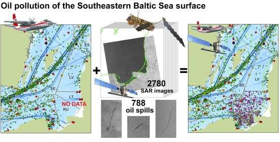
3. Data and Methods
4. Results
4.1. Satellite Observations
4.2. In Situ Measurements
5. Discussion
6. Conclusions
Author Contributions
Funding
Institutional Review Board Statement
Informed Consent Statement
Data Availability Statement
Acknowledgments
Conflicts of Interest
References
- De Mora, S.; Fileman, T.; Vance, T. Environmental Impacts of Shipping: Can We Learn? In Environmental Impact of Ships; Cambridge University Press: Cambridge, UK, 2020; pp. 367–373. [Google Scholar] [CrossRef]
- Patin, S.A. Environmental consequences, monitoring and regulation of the offshore oil and gas development. In Oil and Continental Shelf Ecology, 2nd ed.; VNIRO Publishing: Moscow, Russia, 2017; 284p. (In Russian) [Google Scholar]
- Kostianoy, A.G. Oil Pollution: The Baltic Sea. In Environmental Management Handbook, 2nd ed.; Fath, B.D., Jørgensen, S.E., Cole, M., Eds.; Taylor and Francis, CRC Press: Boca Raton, FL, USA, 2020; Volume 4, Managing Water Resources and Hydrological Systems; pp. 349–368. [Google Scholar] [CrossRef]
- Kostianoy, A.G.; Lavrova, O.Y. Introduction. In Oil Pollution in the Baltic Sea; Kostianoy, A.G., Lavrova, O.Y., Eds.; Springer: Berlin/Heidelberg, Germany, 2014; Volume 27, pp. 1–14. [Google Scholar]
- Chronic oil Pollution in Europe. A Status Report. Available online: https://no0ilcanarias.files.wordpress.com/2013/05/chronic-oil-pollution-in-eu.pdf (accessed on 30 July 2021).
- HELCOM. 2019. Available online: https://helcom.fi/wp-content/uploads/2021/02/Aerial-surveillance-in-the-Baltic-Sea-2019.pdf (accessed on 1 August 2021).
- Shipping. Available online: https://helcom.fi/action-areas/shipping/ (accessed on 1 August 2021).
- Kostianoy, A.G.; Lebedev, S.A.; Litovchenko, K.T.; Stanichny, S.V.; Pichuzhkina, O.E. Oil spill monitoring in the Southeastern Baltic Sea. Environ. Res. Eng. Manag. 2005, 3, 73–79. [Google Scholar]
- Bulycheva, E.; Kuzmenko, I.; Sivkov, V. Annual sea surface oil pollution of the south-eastern part of the Baltic Sea by satellite data for 2006–2013. Baltica 2014, 27, 9–14. [Google Scholar] [CrossRef] [Green Version]
- Krek, E.V.; Krek, A.V.; Kostianoy, A.G.; Semenov, A.V.; Joksimovich, A. Oil pollution of the Southeastern Baltic Sea by satellite remote sensing data and in-situ measurements. Transp. Telecommun. 2015, 16, 296–304. [Google Scholar] [CrossRef] [Green Version]
- Bulycheva, E.V.; Kostianoy, A.G.; Krek, A.V. Interannual variability of sea surface oil pollution in the Southeastern Baltic Sea in 2004−2015. Curr. Probl. Remote Sens. Earth Sp. 2016, 13, 74–84. (In Russian) [Google Scholar] [CrossRef]
- Bulycheva, E.V.; Krek, A.V.; Kostianoy, A.G.; Semenov, A.V.; Joksimovich, A. Oil pollution in the Southeastern Baltic Sea by satellite remote sensing data in 2004–2015. Transp. Telecommun. 2016, 17, 155–163. [Google Scholar] [CrossRef] [Green Version]
- Lavrova, O.Y.; Mityagina, M.I.; Kostianoy, A.G.; Semenov, A.V. Oil pollution in the Southeastern Baltic Sea in 2009–2011. Transp. Telecommun. 2014, 15, 322–331. [Google Scholar] [CrossRef] [Green Version]
- Anderson, S.; Raudsepp, U.; Uiboupin, R. Oil spill statistics from SAR images in the North Eastern Baltic Sea ship route in 2007–2009. In Proceedings of the 2010 IEEE International Geoscience and Remote Sensing Symposium, Honolulu, HI, USA, 25–30 July; pp. 1883–1886. [CrossRef]
- Bulycheva, E.V.; Kostianoy, A.G. Results of satellite monitoring of sea surface oil pollution in Southeastern Baltic Sea in 2004–2013. Curr. Probl. Remote Sens. Earth Sp. 2014, 11, 111–126. (In Russian) [Google Scholar]
- Bulycheva, E.V.; Krek, A.V.; Kostianoy, A.G. Oil pollution in the Southeastern Baltic Sea from satellite observations and in-situ data. Oceanology 2016, 56, 75–83. [Google Scholar] [CrossRef]
- Krek, E.; Kostianoy, A.; Krek, A.; Semenov, A. Spatial distribution of oil spills at the sea surface in the Southeastern Baltic Sea according to satellite SAR data. Transp. Telecommun. 2018, 19, 294–300. [Google Scholar] [CrossRef] [Green Version]
- CleanSeaNet—European Satellite Based Oil Spill Monitoring and Vessel Detection Service. Available online: http://www.emsa.europa.eu/publications/item/4322-cleanseanet-european-satellite-based-oil-spill-monitoring-and-vessel-detection-service.html (accessed on 1 August 2021).
- Solberg, A.H.S.; Brekke, C. Oil Spill Detection in Northern European Waters: Approaches and Algorithms. In Remote Sensing of the European Seas; Barade, V., Gade, M., Eds.; Springer: Berlin/Heidelberg, Germany, 2008; pp. 359–370. [Google Scholar]
- Gade, M.; Baschek, B. The German Operational Monitoring System in the Baltic Sea: Sensors, Methods and Example Data. In Oil Pollution in the Baltic Sea; Kostianoy, A.G., Lavrova, O.Y., Eds.; Springer: Berlin/Heidelberg, Germany, 2014; Volume 27, pp. 65–84. [Google Scholar]
- Kostianoy, A.G.; Litovchenko, K.T.; Lavrova, O.Y.; Mityagina, M.I.; Bocharova, T.Y.; Lebedev, S.A.; Stanichny, S.V.; Soloviev, D.M.; Sirota, A.M.; Pichuzhkina, O.E. Operational satellite monitoring of oil spill pollution in the southeastern Baltic Sea: 18 months experience. Environ. Res. Eng. Manag. 2006, 4, 70–77. [Google Scholar]
- Copernicus Open Access Hub. Available online: https://scihub.copernicus.eu/ (accessed on 1 August 2021).
- EMSA Satellite Based Services (CleanSeaNet). Available online: http://www.emsa.europa.eu/csn-menu/csn-background.html (accessed on 1 August 2021).
- Kostianoy, A.G.; Bulycheva, E.V.; Lavrova, O.Y.; Mityagina, M.I.; Bocharova, T.Y.; Soloviev, D.M.; Sirota, A.M. The unprecedented case of sea surface oil pollution from a ship in the Southeastern Baltic Sea on 23 July 2016. Curr. Probl. Remote Sens. Earth Sp. 2016, 13, 277–281. (In Russian) [Google Scholar]
- Nemirovskaya, I.A. Hydrocarbons in the Oceans: Snow-Ice-Water-Suspended Matter-Bottom Sediments; Nauchny Mir Publ.: Moscow, Russia, 2004; p. 328. (In Russian) [Google Scholar]
- Monitoring Results. (In Russian). Available online: https://kmn.lukoil.ru/ru/Responsibility/Ecology/Reports (accessed on 30 July 2021).
- Krek, A.V.; Krek, E.V.; Danchenkov, A.R.; Krechik, V.A.; Kapustina, M.V. The role of upwellings in the coastal ecosystem of the Southeastern Baltic Sea. Reg. Stud. Mar. Sci. 2021, 44, 101707. [Google Scholar] [CrossRef]
- Krek, A.; Gusev, A.; Krek, E.; Krechik, V.; Kapustina, M.; Kondrashov, A.; Dudkov, I. The pathway of the water exchange over the Gdańsk-Gotland Sill of the Baltic Sea and its impact on habitat formation during the stagnation period. Oceanologia 2021, 63, 163–178. [Google Scholar] [CrossRef]
- Paka, V.; Zhurbas, V.; Golenko, M.; Korzh, A.; Kondrashov, A.; Shchuka, S. Innovative closely spaced profiling and current velocity measurements in the Southern Baltic Sea in 2016–2018 with special reference to the bottom layer. Front. Earth Sci. 2019, 7. [Google Scholar] [CrossRef]
- Hovland, H.A.; Johannessen, J.A.; Digranes, J. Slick detection in SAR images. In Proceedings of the IGARSS’94, 1994: 1994 IEEE International Geoscience and Remote Sensing Symposium, Pasadena, CA, USA, 8–12 August 1994; pp. 2038–2040. [Google Scholar]
- Gade, M.; Alpers, W.; Bao, M. Measurements of the radar backscattering over different oceanic surface films during the SIR-C/XSAR campaigns. In Proceedings of the IGARSS’96: 1996 IEEE International Geoscience and Remote Sensing Symposium, Lincoln, NE, USA, 31 May 1996; Volume 2, pp. 860–862. [Google Scholar]
- Ivanov, A.Y. Assessment of marine oil pollution using KOSMOS-1870 and ALMAZ-1 radar images. Mapp. Sci. Remote Sens. 1998, 35, 202–217. [Google Scholar] [CrossRef]
- Lu, J. Marine oil spill detection, statistics and mapping with ERS SAR imagery in south-east Asia. Int. J. Remote Sens. 2003, 24, 3013–3032. [Google Scholar] [CrossRef]
- Migliaccio, M.; Gambardella, A.; Tranfaglia, M. Oil spill observation by means of polarimetric SAR data. In Proceedings of the SEASAR 2006, Frascati, Italy, 23–26 January 2006. [Google Scholar]
- Topouzelis, K.; Bernardini, A.; Ferraro, G.; Meier-Roux, S.; Tarchi, D. Satellite mapping of oil spills in the Mediterranean Sea. Fresenius Environ. Bull. 2006, 15, 1009–1014. [Google Scholar]
- Shi, L.; Ivanov, A.Y.; He, M.-X.; Zhao, C. Oil spill mapping in the western part of the East China Sea using synthetic aperture radar imagery. Int. J. Remote Sens. 2008, 29, 6315–6329. [Google Scholar] [CrossRef]
- Lavrova, O.Y.; Kostianoy, A.G. Catastrophic oil spill in the Gulf of Mexico in April-May 2010. Izvestiya Atmos. Ocean. Phys. 2011, 47, 1114–1118. [Google Scholar] [CrossRef]
- Lavrova, O.Y.; Mityagina, M.I. Satellite monitoring of oil slicks on the Black Sea surface. Izvestiya Atmos. Ocean. Phys. 2013, 49, 897–912. [Google Scholar] [CrossRef]
- Alpers, W. Remote sensing of African coastal waters using active microwaves instrument. In Remote Sensing of the African Seas; Barale, V., Gade, M., Eds.; Springer: Dordrecht, The Netherlands, 2014; pp. 75–94. [Google Scholar]
- Kostianoy, A.G.; Lavrova, O.Y.; Solovyov, D.M. Oil pollution in coastal waters of Nigeria. In Remote Sensing of the African Seas; Barale, V., Gade, M., Eds.; Springer: Dordrecht, The Netherlands, 2014; pp. 149–165. [Google Scholar]
- Mityagina, M.; Lavrova, O. Satellite survey of inner seas: Oil pollution in the Black and Caspian Seas. Remote Sens. 2016, 8, 875. [Google Scholar] [CrossRef] [Green Version]
- Alpers, W.; Holt, B.; Zeng, K. Oil spill detection by imaging radars: Challenges and pitfalls. Remote Sens. Environ. 2017, 201, 133–147. [Google Scholar] [CrossRef]
- Lavrova, O.Y.; Mityagina, M.I.; Kostianoy, A.G.; Strochkov, M. Monitoring of the Black Sea Ecological Risk Areas. Ecol. Montenegrina 2017, 14, 1–13. [Google Scholar] [CrossRef]
- Lavrova, O.Y.; Mityagina, M.I.; Kostianoy, A.G. Online database “See The Sea” for the Caspian Sea. Ecol. Montenegrina 2019, 25, 79–90. [Google Scholar] [CrossRef]
- Mityagina, M.I.; Lavrova, O.Y.; Kostianoy, A.G. Main pattern of the Caspian Sea surface oil pollution revealed by satellite data. Ecol. Montenegrina 2019, 25, 91–105. [Google Scholar] [CrossRef]
- Kostianoy, A.G.; Kostianaia, E.A.; Soloviev, D.M. Oil pollution in the Mediterranean waters of Egypt. In Environmental Remote Sensing in Egypt; Elbeih, S., Negm, A., Kostianoy, A., Eds.; Springer: Cham, Switzerland, 2020; pp. 305–328. [Google Scholar] [CrossRef]
- Kostianaia, E.A.; Kostianoy, A.G.; Lavrova, O.Y.; Soloviev, D.M. Oil pollution in the Northern Red Sea: A threat to the marine environment and tourism development. In Environmental Remote Sensing in Egypt; Elbeih, S., Negm, A., Kostianoy, A., Eds.; Springer: Cham, Switzerland, 2020; pp. 329–362. [Google Scholar] [CrossRef]
- Kostianoy, A.G.; Lavrova, O.Y. Satellite instrumentation and technique for oil pollution monitoring of the seas. In Instrumentation and Measurement Technologies for Water Cycle Management; Di Mauro, A., Scozzari, A., Soldovieri, F., Eds.; Springer International Publishing AG: Cham, Switzerland, 2022. [Google Scholar]
- Bulycheva, E.V. Oil pollution of the sea surface in 2006–2009 based on satellite radiolocation. In Oil and Environment of the Kaliningrad Region; Sivkov, V.V., Pichuzhkina, O.E., Eds.; Yantarnyi Skaz: Kaliningrad, Russia, 2012; Volume 2, The Sea; pp. 518–529. (In Russian) [Google Scholar]
- Kostianoy, A.G.; Litovchenko, K.T.; Lavrova, O.Y.; Mityagina, M.I.; Bocharova, T.Y.; Lebedev, S.A.; Stanichnyi, S.V.; Solov’ev, D.M.; Sirota, A.M. Integrated operational satellite monitoring in 2004–2005. In Oil and Environment of the Kaliningrad Region; Sivkov, V.V., Pichuzhkina, O.E., Eds.; Yantarnyi Skaz: Kaliningrad, Russia, 2012; Volume 2, The Sea; pp. 483–518. (In Russian) [Google Scholar]
- Bulycheva, E.V.; Kostianoy, A.G. Results of satellite monitoring of oil pollution in the Southeastern Baltic Sea in 2006–2009. Curr. Probl. Remote Sens. Earth Sp. 2011, 8, 74–83. (In Russian) [Google Scholar]
- Ginzburg, A.I.; Krek, E.V.; Kostianoy, A.G.; Soloviev, D.M. Oil spill transport under the influence of mesoscale vortex movement in the South-Eastern Baltic (satellite information: June 2015). J. Oceanol. Res. 2019, 47, 8–19. [Google Scholar] [CrossRef]
- Kostianoy, A.G.; Lavrova, O.Y.; Mityagina, M.I.; Solovyov, D.M.; Lebedev, S.A. Satellite monitoring of oil pollution in the Southeastern Baltic Sea. In Oil Pollution in the Baltic Sea; Kostianoy, A.G., Lavrova, O.Y., Eds.; Springer: Berlin/Heidelberg, Germany, 2014; Volume 27, pp. 125–154. [Google Scholar]
- Lavrova, O.Y.; Kostianoy, A.G.; Lebedev, S.A.; Mityagina, M.I.; Ginzburg, A.I.; Sheremet, N.A. Integrated Satellite Monitoring of Russian Seas; IKI RAN: Moscow, Russia, 2011; p. 470. (In Russian) [Google Scholar]
- Kostianoy, A.G.; Lavrova, O.Y. Oil Pollution in the Baltic Sea; Springer: Berlin/Heidelberg, Germany, 2014; Volume 27, p. 268. [Google Scholar]
- Topouzelis, K.N. Oil spill detection by SAR Images: Dark formation detection, feature extraction and classification algorithms. Sensors 2008, 8, 6642–6659. [Google Scholar] [CrossRef] [Green Version]
- Solberg, A.H.S. Remote sensing of ocean oil-spill pollution. Proc. IEEE 2012, 100, 2931–2945. [Google Scholar] [CrossRef]
- Brekke, C.; Solberg, A.H.S. Oil spill detection by satellite remote sensing. Remote Sens. Environ. 2005, 95, 13. [Google Scholar] [CrossRef]
- Jackson, C.R.; Apel, J.R. Synthetic Aperture Radar Marine User’s Manual; US Department of Commerce, National Oceanic and Atmospheric Administration: Washigton, DC, USA, 2004. Available online: http://www.sarusersmanual.com (accessed on 1 August 2021).
- Lavrova, O.Y.; Mityagina, M.I.; Kostianoy, A.G. Satellite Methods of Detection and Monitoring of Marine Zones of Ecological Risks; Space Research Institute: Moscow, Russia, 2016; p. 336. (In Russian) [Google Scholar]
- Ferraro, G.; Baschek, B.; Montpellier, G.; Njoten, O.; Perkovic, M.; Vespe, M. On the SAR derived alert in the detection of oil spills according to the analysis of the EGEMP. Mar. Pollut. Bull. 2010, 60, 91–102. [Google Scholar] [CrossRef] [PubMed]
- Gelumbauskaitė, L.Ž.; Grigelis, A.; Cato, I.; Repečka, M.; Kjellin, B. Bottom Topography and Sediment Maps of the Central Baltic Sea; Scale 1:500,000. A short description; LGT Series of Marine Geological Maps, N1; SGU Series of Geological Maps Ba No. 54; Lithuanian Institute of Geology: Vilnius, Lithuania, 1999. [Google Scholar] [CrossRef]
- Krek, E.V.; Krek, A.V.; Kostianoy, A.G. Seasonal variability of oil pollution in the Southeastern Baltic Sea. Curr. Probl. Remote Sens. Earth Sp. 2018, 15, 171–182. [Google Scholar] [CrossRef]
- Krek, E.V.; Stont, Z.I.; Bukanova, T.V. Ice conditions in the Southeastern Baltic Sea from satellite data (2004–2019). J. Oceanol. Res. 2020, 48, 18–33. [Google Scholar] [CrossRef]
- Kozlov, I.E.; Krek, E.V.; Kostianoy, A.G.; Dailidienė, I. Remote sensing of ice conditions in the Southeastern Baltic Sea and in the Curonian Lagoon and validation of SAR-based ice thickness products. Remote Sens. 2020, 12, 3754. [Google Scholar] [CrossRef]
- Helcom Map and Data Service. Available online: https://helcom.fi/baltic-sea-trends/data-maps/ (accessed on 1 August 2021).
- Document (1998a) PNDF 14.1:2:4.128-98 Quantitative Chemical Analysis of Water. In Methods of Measurement of the Mass Concentration of Oil in the Samples of Natural, Drinking, Waste Waters by the Fluorimetric Method on the Analyzer of a Liquid “Fluorat-02”; Ministry of Natural Resources of Russian Federation: Moscow, Russia, 1998. (In Russian)
- Document (1998b) PNDF 16.1:2.21-98 Quantitative Chemical Analysis of Soil. In Methods of Measurement of the Mass Fraction of Oil in the Samples of Soil and Ground by the Fluorimetric Method Using the Liquid Analyzer “Fluorat-02”; Ministry of Natural Resources of Russian Federation: Moscow, Russia, 1998. (In Russian)
- Pichuzhkina, O.E.; Sasunkevich, V.P. Oilfield development scheme and environmental safety. In Oil and Environment of the Kaliningrad Region; Sivkov, V.V., Pichuzhkina, O.E., Eds.; Yantarnyi Skaz: Kaliningrad, Russia, 2012; Volume 2, The Sea; pp. 203–218. (In Russian) [Google Scholar]
- Stankevičius, A.; Garnaga, G. Oil Pollution in Waters of Lithuania. In Oil Pollution in the Baltic Sea; Kostianoy, A.G., Lavrova, O.Y., Eds.; Springer: Berlin/Heidelberg, Germany, 2014; Volume 27, pp. 101–124. [Google Scholar] [CrossRef]
- Izrael, Y.A.; Tsyban, A.V. Anthropogenic Ecology of the Ocean; Nauka: Moscow, Ruassia, 2009; p. 532. (In Russian) [Google Scholar]
- Kostianoy, A.G.; Lavrova, O.Y. Conclusions. In Oil Pollution in the Baltic Sea; Kostianoy, A.G., Lavrova, O.Y., Eds.; Springer: Berlin/Heidelberg, Germany, 2014; Volume 27, pp. 249–264. [Google Scholar]


| High Confidence | Medium Confidence | Low Confidence |
|---|---|---|
| The slick has a large contrast to gray-level surroundings | The slick has a diffuse or low contrast to the gray-level surroundings in moderate to high wind speed | Low-wind areas are located nearby |
| The surroundings are homogenous, with a constant gray-level. | The wind speed is moderate to low, (i.e., approximately 3–6 m/s) | Natural slicks (e.g., biological, algae, or fractal streaks at very low wind) are located nearby |
| The wind speed is moderate to high, (i.e., approximately 6–10 m/s) | The shape of the slick is irregular (i.e., the edges are not smooth) | The slick has diffuse edges or an irregular shape |
| Ship or oil installation directly connected to the slick |
| Satellite | Usage Period | Scene Size (km) | Spatial Resolution (m) | Band |
|---|---|---|---|---|
| ENVISAT | from June 2004 to April 2012 | 400 × 400 | 150 × 150 | C |
| RADARSAT-1 | from January 2005 to March 2013 | 300 × 300 | 50 × 50 | C |
| RADARSAT-2 | from December 2008 to December 2020 | 300 × 300 500 × 500 | 50 × 50 100 × 100 | C |
| COSMO-SkyMed-1,-2,-3,-4 | from April 2013 to December 2015 | 200 × 200 | 100 × 100 | C |
| TerraSAR-X/TanDEM-X | from February 2015 to January 2018 | 300 × 300 | 40 × 40 | X |
| Sentinel-1A/B | from January 2016 to December 2020 | 250 × 250 | 10 × 10 | C |
| Year | 2003 | 2004 | 2005 | 2006 | 2007 | 2008 | 2009 | 2010 | |
| Month | 7, 11 | 3, 5, 7, 10 | 3, 5, 7, 10 | 3, 7, 10 | 3, 7, 10 | 3, 7, 11 | 4–10 | 4–10 | |
| Year | 2011 | 2012 | 2013 | 2014 | 2015 | 2017 | 2018 | 2019 | 2020 |
| Month | 1–12 | 1–12 | 1–12 | 1–12 | 1–12 | 1–12 | 1–12 | 1–12 | 1–12 |
Publisher’s Note: MDPI stays neutral with regard to jurisdictional claims in published maps and institutional affiliations. |
© 2021 by the authors. Licensee MDPI, Basel, Switzerland. This article is an open access article distributed under the terms and conditions of the Creative Commons Attribution (CC BY) license (https://creativecommons.org/licenses/by/4.0/).
Share and Cite
Krek, E.V.; Krek, A.V.; Kostianoy, A.G. Chronic Oil Pollution from Vessels and Its Role in Background Pollution in the Southeastern Baltic Sea. Remote Sens. 2021, 13, 4307. https://doi.org/10.3390/rs13214307
Krek EV, Krek AV, Kostianoy AG. Chronic Oil Pollution from Vessels and Its Role in Background Pollution in the Southeastern Baltic Sea. Remote Sensing. 2021; 13(21):4307. https://doi.org/10.3390/rs13214307
Chicago/Turabian StyleKrek, Elena V., Alexander V. Krek, and Andrey G. Kostianoy. 2021. "Chronic Oil Pollution from Vessels and Its Role in Background Pollution in the Southeastern Baltic Sea" Remote Sensing 13, no. 21: 4307. https://doi.org/10.3390/rs13214307