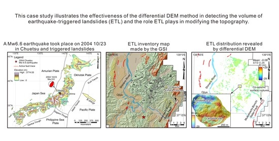
Topographic Evolution Involving Co-Seismic Landslide, Deformation, Long-Term Folding and Isostatic Rebound: A Case Study on the 2004 Chuetsu Earthquake
Abstract
:1. Introduction

2. Tectonic Setting
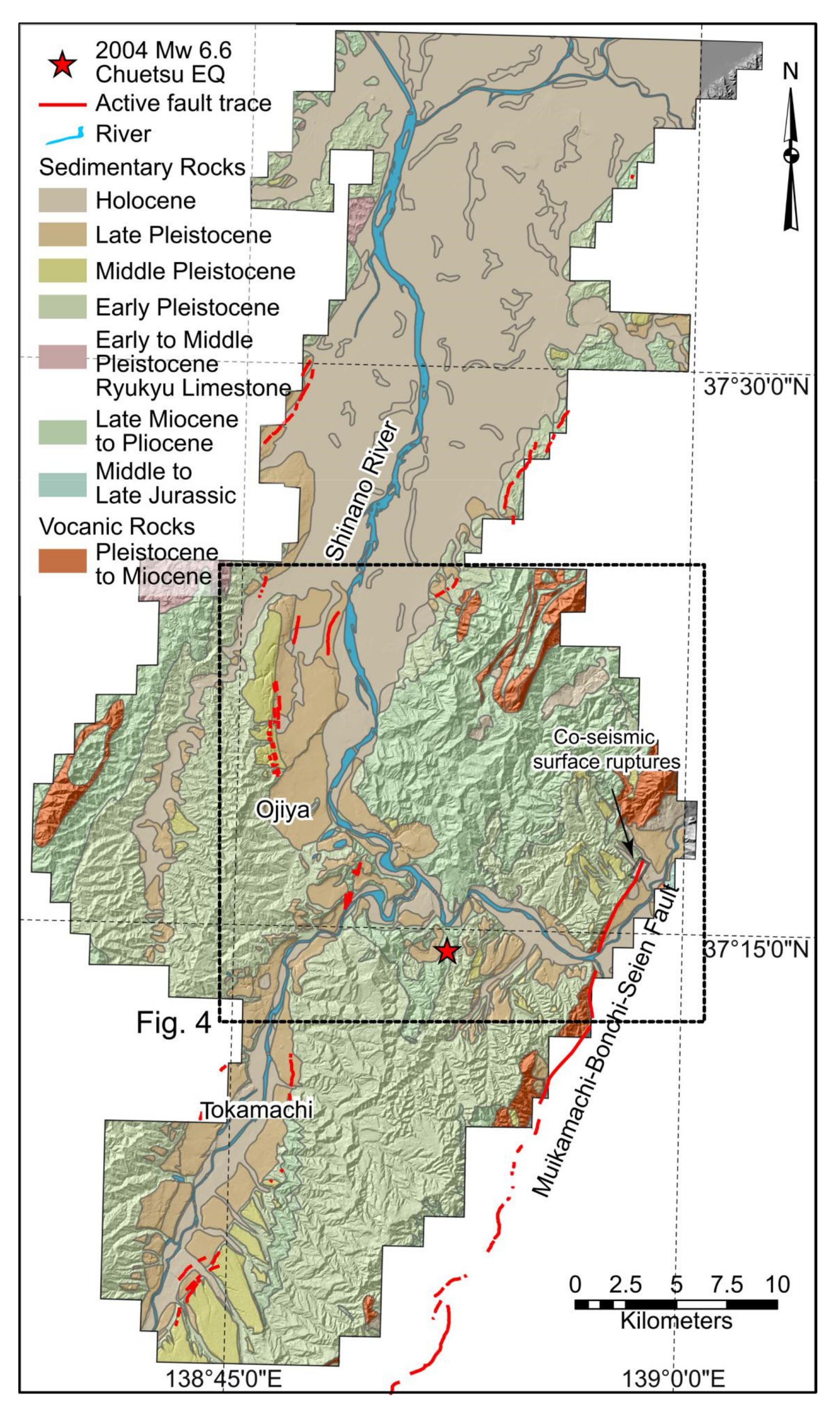
3. Data and Methods
3.1. Data
3.2. Methods
3.2.1. Differential DEM
3.2.2. Topographic Analyses
3.2.3. Catchment-Scale Denudation Depth
3.2.4. Isostatic Response
4. Results
5. Discussion
5.1. Effectiveness of the Differential DEM
5.2. Surface Deformation
6. Conclusions
Author Contributions
Funding
Acknowledgments
Conflicts of Interest
References
- Parker, R.N.; Densmore, A.L.; Rosser, N.J.; de Michele, M.; Li, Y.; Huang, R.; Whadcoat, S.; Petley, D.N. Mass wasting triggered by the 2008 Wenchuan earthquake is greater than orogenic growth. Nat. Geosci. 2011, 4, 449–452. [Google Scholar] [CrossRef] [Green Version]
- Larsen, I.J.; Montgomery, D.R.; Korup, O. Landslide erosion controlled by hillslope material. Nat. Geosci. 2010, 3, 247–251. [Google Scholar] [CrossRef]
- Guzzetti, F.; Ardizzone, F.; Cardinali, M.; Rossi, M.; Valigi, D. Landslide volumes and landslide mobilization rates in Umbria, central Italy. Earth Planet. Sci. Lett. 2009, 279, 222–229. [Google Scholar] [CrossRef]
- Li, G.; West, A.J.; Densmore, A.L.; Jin, Z.; Parker, R.N.; Hilton, R.G. Seismic mountain building: Landslides associated with the 2008 Wenchuan earthquake in the context of a generalized model for earthquake volume balance. Geochem. Geophys. Geosystems 2014, 15, 833–844. [Google Scholar] [CrossRef] [Green Version]
- Ren, Z.; Zhang, Z.; Dai, F.; Yin, J.; Zhang, H. Topographic changes due to the 2008 mw 7.9 Wenchuan earthquake as revealed by the differential dem method. Geomorphology 2014, 217, 122–130. [Google Scholar] [CrossRef]
- Ren, Z.; Zhang, Z.; Yin, J. Erosion associated with seismically-induced landslides in the middle Longmen Shan region, eastern Tibetan plateau, china. Remote Sens. 2017, 9, 864. [Google Scholar] [CrossRef] [Green Version]
- Marc, O.; Hovius, N.; Meunier, P.; Uchida, T.; Hayashi, S. Transient changes of landslide rates after earthquakes. Geology 2015, 43, 883–886. [Google Scholar] [CrossRef]
- Cowgill, E.; Bernardin, T.S.; Oskin, M.E.; Bowles, C.; Yıkılmaz, M.B.; Kreylos, O.; Elliott, A.J.; Bishop, S.; Gold, R.D.; Morelan, A.; et al. Interactive terrain visualization enables virtual field work during rapid scientific response to the 2010 Haiti earthquake. Geosphere 2012, 8, 787–804. [Google Scholar] [CrossRef]
- Stumpf, A.; Malet, J.P.; Allemand, P.; Ulrich, P. Surface reconstruction and landslide displacement measurements with pléiades satellite images. ISPRS J. Photogramm. Remote Sens. 2014, 95, 1–12. [Google Scholar] [CrossRef]
- Zhou, Y.; Elliott, J.R.; Parsons, B.; Walker, R.T. The 2013 balochistan earthquake: An extraordinary or completely ordinary event? Geophys. Res. Lett. 2015, 42, 6236–6243. [Google Scholar] [CrossRef] [Green Version]
- Zielke, O.; Arrowsmith, J.R.; Ludwig, L.G.; Akçiz, S.O. Slip in the 1857 and earlier large earthquakes along the Carrizo plain, San Andreas fault. Science 2010, 327, 1119–1122. [Google Scholar] [CrossRef] [Green Version]
- Lane, S.N.; Chandler, J.H.; Porfiri, K. Monitoring river channel and flume surfaces with digital photogrammetry. J. Hydraul. Eng. 2001, 127, 871–877. [Google Scholar] [CrossRef]
- Wheaton, J.M.; Brasington, J.; Darby, S.E.; Sear, D.A. Accounting for uncertainty in dems from repeat topographic surveys: Improved sediment budgets. Earth Surf. Process. Landf. 2010, 35, 136–156. [Google Scholar] [CrossRef]
- Oskin, M.E.; Arrowsmith, J.R.; Corona, A.H.; Elliott, A.J.; Fletcher, J.M.; Fielding, E.J.; Gold, P.O.; Gonzalez Garcia, J.J.; Hudnut, K.W.; Liu-Zeng, J.; et al. Near-field deformation from the EI Mayor-Cucapah Earthquake revealed by differential LiDAR. Science 2012, 335, 702–704. [Google Scholar] [CrossRef] [Green Version]
- Gardelle, J.; Berthier, E.; Arnaud, Y. Impact of resolution and radar penetration on glacier elevation changes computed from dem differencing. J. Glaciol. 2012, 58, 2014. [Google Scholar] [CrossRef] [Green Version]
- Lague, D.; Brodu, N.; Jérôme, L. Accurate 3D comparison of complex topography with terrestrial laser scanner: Application to the Rangitikei canyon (NZ). ISPRS J. Photogramm. Remote Sens. 2013, 82, 10–26. [Google Scholar] [CrossRef] [Green Version]
- Dehecq, A.; Millan, R.; Berthier, E.; Gourmelen, N.; Trouvé, E.; Vionnet, V. Elevation changes inferred from tandem-x data over the mont-blanc area: Impact of the x-band interferometric bias. IEEE J. Sel. Top. Appl. Earth Obs. Remote Sens. 2016, 9, 3870–3882. [Google Scholar] [CrossRef] [Green Version]
- Lin, G.; Shearer, P.; Fialko, Y. Obtaining absolute locations for quarry seismicity using remote sensing data. Bull. Seismol. Soc. Am. 2015, 96, 722–728. [Google Scholar] [CrossRef]
- Asaka, T.; Iwashita, K.; Kudou, K.; Aoyama, S.; Yamamoto, Y. Change detection method for landslide area using RGB color composite image of SRTM and ALOS/PALSAR InSAR DEM: A case study of the Iwate-Miyagi Nairiku Earthquake in 2008. In Proceedings of the 2011 IEEE International Geoscience and Remote Sensing Symposium, Vancouver, BC, Canada, 24–29 July 2011. [Google Scholar]
- Lacroix, P. Landslides triggered by the gorkha earthquake in the langtang valley, volumes and initiation processes. Earth Planets Space 2016, 68, 46. [Google Scholar] [CrossRef] [Green Version]
- Avouac, J.-P. Mountain Building, Erosion, and the Seismic Cycle in the Nepal Himalaya. In Advances in Geophysics; Dmowska, R., Ed.; Elsevier: Amsterdam, The Netherlands, 2003; Volume 46, pp. 1–80. [Google Scholar]
- Larsen, I.J.; Montgomery, D.R. Landslide erosion coupled to tectonics and river incision. Nat. Geosci. 2012, 5, 468–473. [Google Scholar] [CrossRef]
- Morell, K.D.; Sandiford, M.; Rajendran, C.P.; Rajendran, K.; Alimanovic, A.; Fink, D.; Sanwal, J. Geomorphology reveals active décollement geometry in the central himalayan seismic gap. Lithosphere 2015, 7, 247–256. [Google Scholar] [CrossRef] [Green Version]
- Owen, L.A. Landscape development of the Himalayan–Tibetan orogen: A review. Geol. Soc. Lond. Spec. Publ. 2010, 338, 389–407. [Google Scholar] [CrossRef] [Green Version]
- Hovius, N.; Meunier, P.; Lin, C.-W.; Chen, H.; Chen, Y.-G.; Dadson, S.; Horng, M.-J.; Lines, M. Prolonged seismically induced erosion and the mass balance of a large earthquake. Earth Planet. Sci. Lett. 2011, 304, 347–355. [Google Scholar] [CrossRef]
- McPhillips, D.; Bierman, P.R.; Rood, D.H. Millennial-scale record of landslides in the andes consistent with earthquake trigger. Nat. Geosci. 2014, 7, 925–930. [Google Scholar] [CrossRef]
- Wang, K.; Fialko, Y. Observations and modeling of coseismic and postseismic deformation due to the 2015 Mw 7.8 Gorkha (Nepal) earthquake. J. Geophys. Res. Solid Earth 2018, 123, 761–779. [Google Scholar] [CrossRef]
- Blöthe, J.H.; Korup, O.; Schwanghart, W. Large landslides lie low: Excess topography in the Himalaya-Karakoram ranges. Geology 2015, 43, 523–526. [Google Scholar] [CrossRef]
- Burbank, D.W.; Leland, J.; Fielding, E.; Anderson, R.S.; Brozovic, N.; Reid, M.R.; Duncan, C. Bedrock incision, rock uplift and threshold hillslopes in the northwestern Himalayas. Nature 1996, 379, 505–510. [Google Scholar] [CrossRef]
- Roering, J. Tectonic geomorphology: Landslides limit mountain relief. Nat. Geosci. 2012, 5, 446–447. [Google Scholar] [CrossRef]
- Kirby, E.; Reiners, P.W.; Krol, M.A.; Whipple, K.X.; Hodges, K.V.; Farley, K.A.; Tang, W.; Chen, Z. Late Cenozoic evolution of the eastern margin of the Tibetan plateau: Inferences from 40ar/39ar and (u-th)/he thermochronology. Tectonics 2002, 21, 1-1-1-20. [Google Scholar] [CrossRef] [Green Version]
- Wang, E.; Kirby, E.; Furlong, K.P.; van Soest, M.; Xu, G.; Shi, X.; Kamp, P.J.J.; Hodges, K.V. Two-phase growth of high topography in eastern Tibet during the cenozoic. Nat. Geosci. 2012, 5, 640–645. [Google Scholar] [CrossRef]
- Ansberque, C.; Godard, V.; Bellier, O.; De Sigoyer, J.; Liu-Zeng, J.; Xu, X.; Ren, Z.; Li, Y.; Team, A.S.T.E.R. Denudation pattern across the Longriba fault system and implications for the geomorphological evolution of the eastern Tibetan margin. Geomorphology 2015, 246, 542–557. [Google Scholar] [CrossRef]
- Godard, V.; Lavé, J.; Carcaillet, J.; Cattin, R.; Bourlès, D.; Zhu, J. Spatial distribution of denudation in eastern Tibet and regressive erosion of plateau margins. Tectonophysics 2010, 491, 253–274. [Google Scholar] [CrossRef]
- Ouimet, W.B. Landslides associated with the May 12, 2008 Wenchuan earthquake: Implications for the erosion and tectonic evolution of the Longmen shan. Tectonophysics 2010, 491, 244–252. [Google Scholar] [CrossRef]
- Dadson, S.J.; Hovius, N.; Chen, H.; Dade, W.B.; Hsieh, M.-L.; Willett, S.D.; Hu, J.-C.; Horng, M.-J.; Chen, M.-C.; Stark, C.P.; et al. Links between erosion, runoff variability and seismicity in the Taiwan orogen. Nature 2003, 426, 648–651. [Google Scholar] [CrossRef]
- Geographical Survey Institute (GSI). 2 m Grid Elevation Data; Geographical Survey Institute (GSI): Tsukuba, Japan, 2007. [Google Scholar]
- RGAFJ. Active Faults in Japan: Sheet Maps and Inventories (Revised Edition); University of Tokyo Press: Tokyo, Japan, 1991. [Google Scholar]
- Nakata, T.; Imaizumi, T. Digital Active Fault Map of Japan; University of Tokyo Press: Tokyo, Japan, 2002. [Google Scholar]
- Okamura, Y.; Ishiyama, T.; Yanagisawa, Y. Fault-related folds above the source fault of the 2004 mid-Niigata prefecture earthquake, in a fold-and-thrust belt caused by basin inversion along the eastern margin of the japan sea. J. Geophys. Res. Solid Earth 2007, 112, B03S08. [Google Scholar] [CrossRef] [Green Version]
- Okamura, Y.; Watanabe, M.; Morijiri, R.; Satoh, M. Rifting and basin inversion in the eastern margin of the Japan sea. Island Arc. 1995, 4, 166–181. [Google Scholar] [CrossRef]
- Wei, D.; Seno, T. Determination of the Amurian Plate Motion. In Mantle Dynamics and Plate Interactions in East Asia; Flower, M.F.J., Chung, S.L., Lo, C.H., Lee, C.F., Eds.; American Geophysical Union: Washington, DC, USA, 1998; Volume 27, pp. 337–346. [Google Scholar]
- Hirata, N.; Sato, H.; Sakai, S.i.; Kato, A.; Kurashimo, E. Fault system of the 2004 mid Niigata prefecture earthquake and its aftershocks. Landslides 2005, 2, 153–157. [Google Scholar] [CrossRef]
- Okamura, Y. Fault-related folds and an imbricate thrust system on the northwestern margin of the northern Fossa magna region, central Japan. Island Arc 2003, 12, 61–73. [Google Scholar] [CrossRef]
- Sato, H. The relationship between late Cenozoic tectonic events and stress field and basin development in northeast Japan. J. Geophys. Res. 1994, 99, 22261–22274. [Google Scholar] [CrossRef]
- Kato, A.; Kurashimo, E.; Hirata, N.; Sakai, S.; Iwasaki, T.; Kanazawa, T. Imaging the source region of the 2004 mid-Niigata prefecture earthquake and the evolution of a seismogenic thrust-related fold. Geophys. Res. Lett. 2005, 32, L07307. [Google Scholar] [CrossRef]
- Kato, A.; Sakai, S.i.; Hirata, N.; Kurashimo, E.; Iidaka, T.; Iwasaki, T.; Kanazawa, T. Imaging the seismic structure and stress field in the source region of the 2004 mid-Niigata prefecture earthquake: Structural zones of weakness and seismogenic stress concentration by ductile flow. J. Geophys. Res. Solid Earth 2006, 111, B08308. [Google Scholar] [CrossRef]
- Maruyama, T.; Fusejima, Y.; Yoshioka, T.; Awata, Y.; Matsu’ura, T. Characteristics of the surface rupture associated with the 2004 mid Niigata prefecture earthquake, central Japan and their seismotectonic implications. Earth Planet Space 2005, 57, 521–526. [Google Scholar] [CrossRef] [Green Version]
- Suppe, J. Geometry and kinematics of fault-bend folding. Am. J. Sci. 1983, 283, 684–721. [Google Scholar] [CrossRef]
- Chigira, M.; Yagi, H. Geological and geomorphological characteristics of landslides triggered by the 2004 mid Niigta prefecture earthquake in japan. Eng. Geol. 2006, 82, 202–221. [Google Scholar] [CrossRef]
- Dou, J.; Paudel, U.; Oguchi, T.; Uchiyama, S.; Hayakawa, Y. Shallow and deep-seated landslide differentiation using support vector machines: A case study of the Chuetsu area, Japan. Terrestial Atmos. Ocean. Sci. 2015, 26, 227–239. [Google Scholar] [CrossRef] [Green Version]
- Sato, H.; Sekiguchi, T.; Kojiroi, R.; Suzuki, Y.; Iida, M. Overlaying landslides distribution on the earthquake source, geological and topographical data: The mid Niigata prefecture earthquake in 2004, Japan. Landslides 2005, 2, 143–152. [Google Scholar] [CrossRef]
- Wang, H.B.; Sassa, K.; Xu, W.Y. Analysis of a spatial distribution of landslides triggered by the 2004 Chuetsu earthquakes of Niigata prefecture, Japan. Nat. Hazards 2007, 41, 43–60. [Google Scholar] [CrossRef]
- Chen, R.-F.; Chang, K.-J.; Angelier, J.; Chan, Y.-C.; Deffontaines, B.; Lee, C.-T.; Lin, M.-L. Topographical changes revealed by high-resolution airborne LiDAR data: The 1999 Tsaoling landslide induced by the Chi–chi earthquake. Eng. Geol. 2006, 88, 160–172. [Google Scholar] [CrossRef]
- Nissen, E.; Maruyama, T.; Ramon Arrowsmith, J.; Elliott, J.R.; Krishnan, A.K.; Oskin, M.E.; Saripalli, S. Coseismic fault zone deformation revealed with differential LiDAR: Examples from Japanese ∼7 intraplate earthquakes. Earth Planet. Sci. Lett. 2014, 405, 244–256. [Google Scholar] [CrossRef]
- Huang, Y.; Yu, M.; Xu, Q.; Sawada, K.; Moriguchi, S.; Yashima, A.; Liu, C.; Xue, L. InSAR-derived digital elevation models for terrain change analysis of earthquake-triggered flow-like landslides based on ALOS/PALSAR imagery. Environ. Earth Sci. 2014, 73, 7661–7668. [Google Scholar] [CrossRef]
- Ayoub, F.; Leprince, S.; Avouac, J.P. Users Guide to Cosi-Corr Co-Registration of Optically Sensed Images and Correlation. Available online: http://www.tectonics.caltech.edu/slip_history/spot_coseis/pdf_files/CosiCorr-Guide2015a.pdf (accessed on 10 February 2021).
- Hollingsworth, J.; Leprince, S.; Ayoub, F.; Avouac, J.-P. Deformation during the 1975–1984 Krafla rifting crisis, NE Iceland, measured from historical optical imagery. J. Geophys. Res. Solid Earth 2012, 117, B11407. [Google Scholar] [CrossRef] [Green Version]
- Leprince, S.; Barbot, S.; Ayoub, F.; Avouac, J.P. Automatic and precise orthorectification, coregistration, and subpixel correlation of satellite images, application to ground deformation measurements. Geosci. Remote Sens. IEEE Trans. 2007, 45, 1529–1558. [Google Scholar] [CrossRef] [Green Version]
- Dai, F.C.; Lee, C.F. Landslide characteristics and slope instability modeling using GIS, Lantau Island, Hong Kong. Geomorphology 2002, 42, 213–228. [Google Scholar] [CrossRef]
- Densmore, A.L.; Ellis, M.A.; Anderson, R.S. Landsliding and the evolution of normal-fault-bounded mountains. J. Geophys. Res. Solid Earth 1998, 103, 15203–15219. [Google Scholar] [CrossRef] [Green Version]
- Ren, Z.; Lin, A. Co-seismic landslides induced by the 2008 Wenchuan magnitude 8.0 earthquake, as revealed by ALOS prism and AVNIR2 imagery data. Int. J. Remote Sens. 2010, 31, 3479–3493. [Google Scholar] [CrossRef]
- Hovius, N.; Stark, C.P.; Allen, P.A. Sediment flux from a mountain belt derived by landslide mapping. Geology 1997, 25, 231–234. [Google Scholar] [CrossRef] [Green Version]
- Li, G.; West, A.J.; Qiu, H.R. Competing Effects of Mountain Uplift and Landslide Erosion over Earthquake Cycles. J. Geophys. Res. Solid Earth 2019, 124, 5101–5133. [Google Scholar] [CrossRef] [Green Version]
- Champagnac, J.D.; Molnar, P.; Anderson, R.S.; Sue, C.; Delacou, B. Quaternary erosion-induced isostatic rebound in the western Alps. Geology 2007, 35, 195–198. [Google Scholar] [CrossRef] [Green Version]
- Zhang, H.P.; Zhang, P.Z.; Champagnac, J.D.; Molnar, P.; Anderson, R.S.; Kirby, E.; Craddock, W.H.; Liu, S.F. Pleistocene drainage reorganization driven by the isostatic response to deep incision into the northeastern Tibetan plateau. Geology 2014, 42, 303–306. [Google Scholar] [CrossRef] [Green Version]
- Kudo, T.; Yamaji, A.; Furumoto, M.; Nagao, T. Effective elastic thickness of island arc lithosphere under Japan. Island Arc 2001, 10, 135–144. [Google Scholar] [CrossRef]
- Tsutsui, K.; Miyazaki, S.; Rokugawa, S. Estimation of landslide volume based on high-accurate elevation change using SPOT5 satellite image data: Case study of the mid Niigata prefecture earthquake in 2004. Tech. Rep. Ieice Sane 2005, 105, 11–15. [Google Scholar]
- Ozawa, T.; Nishimura, S.; Wada, Y.; Ohkura, H. Coseismic deformation of the mid Niigata prefecture earthquake in 2004 detected by radarsat/insar. Earth Planets Space 2005, 57, 423–428. [Google Scholar] [CrossRef] [Green Version]
- Jacobs, A.; Sandwell, D.; Fialko, Y.; Sichoix, L. The 1999 (mw 7.1) Hector mine, California, earthquake: Near-field postseismic deformation from ers interferometry. Bull. Seismol. Soc. Am. 2002, 92, 1433–1442. [Google Scholar] [CrossRef]
- Maruyama, T.; Iemura, K.; Azuma, T.; Yoshioka, T.; Sato, M.; Miyawaki, R. Paleoseismological evidence for non-characteristic behavior of surface rupture associated with the 2004 mid-Niigata prefecture earthquake, central Japan. Tectonophysics 2007, 429, 45–60. [Google Scholar] [CrossRef]



Publisher’s Note: MDPI stays neutral with regard to jurisdictional claims in published maps and institutional affiliations. |
© 2021 by the authors. Licensee MDPI, Basel, Switzerland. This article is an open access article distributed under the terms and conditions of the Creative Commons Attribution (CC BY) license (http://creativecommons.org/licenses/by/4.0/).
Share and Cite
Lei, J.; Ren, Z.; Oguchi, T.; Zhang, P.; Uchiyama, S. Topographic Evolution Involving Co-Seismic Landslide, Deformation, Long-Term Folding and Isostatic Rebound: A Case Study on the 2004 Chuetsu Earthquake. Remote Sens. 2021, 13, 1073. https://doi.org/10.3390/rs13061073
Lei J, Ren Z, Oguchi T, Zhang P, Uchiyama S. Topographic Evolution Involving Co-Seismic Landslide, Deformation, Long-Term Folding and Isostatic Rebound: A Case Study on the 2004 Chuetsu Earthquake. Remote Sensing. 2021; 13(6):1073. https://doi.org/10.3390/rs13061073
Chicago/Turabian StyleLei, Jinghao, Zhikun Ren, Takashi Oguchi, Peizhen Zhang, and Shoichiro Uchiyama. 2021. "Topographic Evolution Involving Co-Seismic Landslide, Deformation, Long-Term Folding and Isostatic Rebound: A Case Study on the 2004 Chuetsu Earthquake" Remote Sensing 13, no. 6: 1073. https://doi.org/10.3390/rs13061073
APA StyleLei, J., Ren, Z., Oguchi, T., Zhang, P., & Uchiyama, S. (2021). Topographic Evolution Involving Co-Seismic Landslide, Deformation, Long-Term Folding and Isostatic Rebound: A Case Study on the 2004 Chuetsu Earthquake. Remote Sensing, 13(6), 1073. https://doi.org/10.3390/rs13061073


