
Improving Soil Moisture Estimation via Assimilation of Remote Sensing Product into the DSSAT Crop Model and Its Effect on Agricultural Drought Monitoring

Abstract
:
1. Introduction
2. Study Area and Data
2.1. Study Area
2.2. Data
2.2.1. Meteorological Data
2.2.2. Agro-Meteorological Data
2.2.3. Satellite Soil Moisture
3. Methods
3.1. Crop Model Description and Verification
3.2. Assimilation Algorithms
3.3. Data Assimilation Implementation
3.4. Agricultural Drought Index
3.5. Evaluation Criteria
4. Results
4.1. Comparisons of Open-Loop and Assimilated Soil Moisture
4.1.1. Soil Moisture at Different Depths
4.1.2. Root-Zone Soil Moisture
4.2. Impacts of Different Strategies on Data Assimilation
4.2.1. Impact of Simultaneous State-Parameter Estimation
4.2.2. Impact of Ensemble Size
4.2.3. Impact of Temporal Interval
4.3. Effect of Data Assimilation on Agricultural Drought Monitoring
4.3.1. Comparison with Observed Soil Moisture-Based Drought Index
4.3.2. Comparison with Winter Wheat Yield
5. Discussion
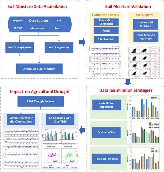
6. Conclusions
- (1)
- Compared with open-loop simulations, crop growth model-based data assimilation effectively improved soil moisture estimation throughout the soil profile. Soil moisture in the root zone was more consistent with in situ observation (RMSE = 0.035 m3·m−3, R = 0.742) than that in other soil layers;
- (2)
- Simultaneous state-parameter estimation (based on AEnKF algorithm) performed better than state-only estimation (based on EnKF algorithm). As the observation frequency and ensemble size increased, the accuracy of soil moisture estimates also increased. In the case of a comprehensive consideration of estimation accuracy and calculation cost, observation frequency within five days with twenty ensemble members could meet the requirement of soil moisture accuracy;
- (3)
- Compared with the drought index based on open-loop soil moisture, the drought index based on assimilated results improves at least one drought level in agricultural drought monitoring. Additionally, the drought index based on assimilated soil moisture was better correlated with winter wheat yield than that based on open-loop simulation.
Author Contributions
Funding
Data Availability Statement
Acknowledgments
Conflicts of Interest
References
- Mishra, A.K.; Singh, V.P. A review of drought concepts. J. Hydrol. 2010, 391, 202–216. [Google Scholar] [CrossRef]
- Martínez-Fernández, J.; González-Zamora, A.; Sánchez, N.; Gumuzzio, A. A soil water based index as a suitable agricultural drought indicator. J. Hydrol. 2015, 522, 265–273. [Google Scholar] [CrossRef]
- AghaKouchak, A.; Farahmand, A.M.; Melton, F.S.; Teixeira, J.P.; Anderson, M.; Wardlow, B.; Hain, C.R. Remote sensing of drought: Progress, challenges and opportunities. Rev. Geophys. 2015, 53, 452–480. [Google Scholar] [CrossRef] [Green Version]
- Liu, X.; Pan, Y.; Zhu, X.; Yang, T.; Bai, J.; Sun, Z. Drought evolution and its impact on the crop yield in the North China Plain. J. Hydrol. 2018, 564, 984–996. [Google Scholar] [CrossRef]
- Samaniego, L.; Thober, S.; Kumar, R.; Wanders, N.; Rakovec, O.; Pan, M.; Zink, M.; Sheffield, J.; Wood, E.F.; Marx, A. Anthropogenic warming exacerbates European soil moisture droughts. Nat. Clim. Chang. 2018, 8, 421–426. [Google Scholar] [CrossRef]
- Mora, C.; Spirandelli, D.; Franklin, E.C.; Lynham, J.; Kantar, M.B.; Miles, W.; Smith, C.Z.; Freel, K.; Moy, J.; Louis, L.V.; et al. Broad threat to humanity from cumulative climate hazards intensified by greenhouse gas emissions. Nat. Clim. Chang. 2018, 8, 1062–1071. [Google Scholar] [CrossRef]
- Crow, W.T.; Kumar, S.V.; Bolten, J.D. On the utility of land surface models for agricultural drought monitoring. Hydrol. Earth Syst. Sci. 2012, 16, 3451–3460. [Google Scholar] [CrossRef] [Green Version]
- Sheffield, J.; Goteti, G.; Wen, F.; Wood, E. A simulated soil moisture based drought analysis for the United States. J. Geophys. Res. D Atmos. 2004, 109, D24108. [Google Scholar] [CrossRef]
- Dutra, E.; Viterbo, P.; Miranda, P.M.A. ERA-40 reanalysis hydrological applications in the characterization of regional drought. Geophys. Res. Lett. 2008, 35, L19402. [Google Scholar] [CrossRef]
- Carrão, H.; Russo, S.; Sepulcre-Canto, G.; Barbosa, P. An empirical standardized soil moisture index for agricultural drought assessment from remotely sensed data. Int. J. Appl. Earth Obs. Geoinf. 2016, 48, 74–84. [Google Scholar] [CrossRef]
- Sridhar, V.; Hubbard, K.G.; You, J.; Hunt, E.D. Development of the Soil Moisture Index to Quantify Agricultural Drought and Its “User Friendliness” in Severity-Area-Duration Assessment. J. Hydrometeorol. 2008, 9, 660–676. [Google Scholar] [CrossRef] [Green Version]
- Hunt, E.D.; Hubbard, K.G.; Wilhite, D.A.; Arkebauer, T.J.; Dutcher, A.L. The development and evaluation of a soil moisture index. Int. J. Climatol. 2009, 29, 747–759. [Google Scholar] [CrossRef]
- Zhou, H.; Wu, J.; Geng, G.; Li, X.; Wang, Q.; Lei, T.; Mo, X.; Liu, L. Enhancing the Ability of a Soil Moisture-based Index for Agricultural Drought Monitoring by Incorporating Root Distribution. JAWRA J. Am. Water Resour. Assoc. 2017, 53, 1409–1423. [Google Scholar] [CrossRef]
- Peng, J.; Albergel, C.; Balenzano, A.; Brocca, L.; Cartus, O.; Cosh, M.H.; Crow, W.T.; Dabrowska-Zielinska, K.; Dadson, S.; Davidson, M.W.; et al. A roadmap for high-resolution satellite soil moisture applications—Confronting product characteristics with user requirements. Remote Sens. Environ. 2020, 252, 112162. [Google Scholar] [CrossRef]
- Li, Z.-L.; Leng, P.; Zhou, C.; Chen, K.-S.; Zhou, F.-C.; Shang, G.-F. Soil moisture retrieval from remote sensing measurements: Current knowledge and directions for the future. Earth-Sci. Rev. 2021, 218, 103673. [Google Scholar] [CrossRef]
- Babaeian, E.; Sadeghi, M.; Jones, S.B.; Montzka, C.; Vereecken, H.; Tuller, M. Ground, Proximal, and Satellite Remote Sensing of Soil Moisture. Rev. Geophys. 2019, 57, 530–616. [Google Scholar] [CrossRef] [Green Version]
- Baldwin, D.; Manfreda, S.; Keller, K.; Smithwick, E. Predicting root zone soil moisture with soil properties and satellite near-surface moisture data across the conterminous United States. J. Hydrol. 2017, 546, 393–404. [Google Scholar] [CrossRef]
- Dorigo, W.; Wagner, W.; Albergel, C.; Albrecht, F.; Balsamo, G.; Brocca, L.; Chung, D.; Ertl, M.; Forkel, M.; Gruber, A.; et al. ESA CCI Soil Moisture for improved Earth system understanding: State-of-the art and future directions. Remote Sens. Environ. 2017, 203, 185–215. [Google Scholar] [CrossRef]
- Mishra, A.K.; Ines, A.V.M.; Das, N.N.; Prakash Khedun, C.; Singh, V.P.; Sivakumar, B.; Hansen, J.W.; Mishra, A.K.; Sivakumar, B.; Singh, V.P. Anatomy of a local scale drought; application of assimilated remote sensing products, crop model, and statistical methods to an agricultural drought study. J. Hydrol. 2015, 526, 15–29. [Google Scholar] [CrossRef]
- Sahoo, A.K.; De Lannoy, G.J.; Reichle, R.H.; Houser, P.R. Assimilation and downscaling of satellite observed soil moisture over the Little River Experimental Watershed in Georgia, USA. Adv. Water Resour. 2013, 52, 19–33. [Google Scholar] [CrossRef]
- Parrens, M.; Mahfouf, J.-F.; Barbu, A.L.; Calvet, J.-C. Assimilation of surface soil moisture into a multilayer soil model: Design and evaluation at local scale. Hydrol. Earth Syst. Sci. 2014, 18, 673–689. [Google Scholar] [CrossRef] [Green Version]
- Sabater, J.M.; Jarlan, L.; Calvet, J.-C.; Bouyssel, F.; De Rosnay, P. From Near-Surface to Root-Zone Soil Moisture Using Different Assimilation Techniques. J. Hydrometeorol. 2007, 8, 194–206. [Google Scholar] [CrossRef]
- Huang, C.; Li, X.; Lu, L. Retrieving soil temperature profile by assimilating MODIS LST products with ensemble Kalman filter. Remote Sens. Environ. 2008, 112, 1320–1336. [Google Scholar] [CrossRef]
- Kumar, S.; Peters-Lidard, C.; Mocko, D.; Reichle, R.; Liu, Y.; Arsenault, K.; Xia, Y.; Ek, M.; Riggs, G.; Livneh, B.; et al. Assimilation of Remotely Sensed Soil Moisture and Snow Depth Retrievals for Drought Estimation. J. Hydrometeorol. 2014, 15, 2446–2469. [Google Scholar] [CrossRef]
- Han, E.; Crow, W.T.; Holmes, T.; Bolten, J. Benchmarking a Soil Moisture Data Assimilation System for Agricultural Drought Monitoring. J. Hydrometeorol. 2014, 15, 1117–1134. [Google Scholar] [CrossRef]
- Bolten, J.D.; Crow, W.T.; Zhan, X.; Jackson, T.J.; Reynolds, C.A. Evaluating the Utility of Remotely Sensed Soil Moisture Retrievals for Operational Agricultural Drought Monitoring. IEEE J. Sel. Top. Appl. Earth Obs. Remote Sens. 2009, 3, 57–66. [Google Scholar] [CrossRef] [Green Version]
- Sun, X.; Lai, P.; Wang, S.; Song, L.; Ma, M.; Han, X. Monitoring of Extreme Agricultural Drought of the Past 20 Years in Southwest China Using GLDAS Soil Moisture. Remote Sens. 2022, 14, 1323. [Google Scholar] [CrossRef]
- De Lannoy, G.J.M.; Reichle, R.H. Assimilation of SMOS brightness temperatures or soil moisture retrievals into a land surface model. Hydrol. Earth Syst. Sci. 2016, 20, 4895–4911. [Google Scholar] [CrossRef] [Green Version]
- Seo, E.; Lee, M.-I.; Reichle, R.H. Assimilation of SMAP and ASCAT soil moisture retrievals into the JULES land surface model using the Local Ensemble Transform Kalman Filter. Remote Sens. Environ. 2020, 253, 112222. [Google Scholar] [CrossRef]
- Monsivais-Huertero, A.; Graham, W.; Judge, J.; Agrawal, D. Effect of simultaneous state–parameter estimation and forcing uncertainties on root-zone soil moisture for dynamic vegetation using EnKF. Adv. Water Resour. 2010, 33, 468–484. [Google Scholar] [CrossRef]
- Dong, T.; Liu, J.; Qian, B.; Zhao, T.; Jing, Q.; Geng, X.; Wang, J.; Huffman, T.; Shang, J. Estimating winter wheat biomass by assimilating leaf area index derived from fusion of Landsat-8 and MODIS data. Int. J. Appl. Earth Obs. Geoinf. 2016, 49, 63–74. [Google Scholar] [CrossRef]
- Huang, J.; Sedano, F.; Huang, Y.; Ma, H.; Li, X.; Liang, S.; Tian, L.; Zhang, X.; Fan, J.; Wu, W. Assimilating a synthetic Kalman filter leaf area index series into the WOFOST model to improve regional winter wheat yield estimation. Agric. For. Meteorol. 2016, 216, 188–202. [Google Scholar] [CrossRef]
- Huang, J.; Tian, L.; Liang, S.; Ma, H.; Becker-Reshef, I.; Huang, Y.; Su, W.; Zhang, X.; Zhu, D.; Wu, W. Improving winter wheat yield estimation by assimilation of the leaf area index from Landsat TM and MODIS data into the WOFOST model. Agric. For. Meteorol. 2015, 204, 106–121. [Google Scholar] [CrossRef] [Green Version]
- Ines, A.V.; Das, N.N.; Hansen, J.W.; Njoku, E.G. Assimilation of remotely sensed soil moisture and vegetation with a crop simulation model for maize yield prediction. Remote Sens. Environ. 2013, 138, 149–164. [Google Scholar] [CrossRef] [Green Version]
- Jiang, Z.; Chen, Z.; Chen, J.; Ren, J.; Li, Z.; Sun, L. The Estimation of Regional Crop Yield Using Ensemble-Based Four-Dimensional Variational Data Assimilation. Remote Sens. 2014, 6, 2664–2681. [Google Scholar] [CrossRef] [Green Version]
- Ren, S.; Guo, B.; Wu, X.; Zhang, L.; Ji, M.; Wang, J. Winter wheat planted area monitoring and yield modeling using MODIS data in the Huang-Huai-Hai Plain, China. Comput. Electron. Agric. 2021, 182, 106049. [Google Scholar] [CrossRef]
- National Bureau of Statistics of China. China Statistical Yearbook; National Bureau of Statistics of China: Beijing, China, 2021.
- Hou, M. Study of Agricultural Structure Adjustment and Agricultural Development Stratagem on HuangHuaiHai Plain. Ph.D. Thesis, China Agricultural University, Beijing, China, 2004. [Google Scholar]
- Xu, J.; Ju, H.; Mei, X.; Liu, Q.; Yang, J. Simulation on potential effects of drought on winter wheat in Huang-Huai-Hai Plain from 1981 to 2010. Trans. Chin. Soc. Agric. Eng. 2015, 31, 150–158. (In Chinese) [Google Scholar] [CrossRef]
- Allen, R.G.; Pereira, L.S.; Raes, D.; Smith, M. Crop Evapotranspiration—Guidelines for Computing Reference Crop Evapo-Transpiration; FAO Irrigation and Drainage Paper No. 56; FAO: Rome, Italy, 1998; pp. 1–15. [Google Scholar]
- Liu, Y.Y.; Dorigo, W.A.; Parinussa, R.M.; de Jeu, R.A.M.; Wagner, W.; McCabe, M.F.; Evans, J.P.; van Dijk, A.I.J.M. Trend-preserving blending of passive and active microwave soil moisture retrievals. Remote Sens. Environ. 2012, 123, 280–297. [Google Scholar] [CrossRef]
- Gruber, A.; Dorigo, W.A.; Crow, W.; Wagner, W. Triple Collocation-Based Merging of Satellite Soil Moisture Retrievals. IEEE Trans. Geosci. Remote Sens. 2017, 55, 6780–6792. [Google Scholar] [CrossRef]
- Jones, J.W.; Hoogenboom, G.; Porter, C.H.; Boote, K.J.; Batchelor, W.D.; Hunt, L.A.; Wilkens, P.W.; Singh, U.; Gijsman, A.J.; Ritchie, J.T. The DSSAT cropping system model. Eur. J. Agron. 2003, 18, 235–265. [Google Scholar] [CrossRef]
- Ritchie, J.T. Model for predicting evaporation from a row crop with incomplete cover. Water Resour. Res. 1972, 8, 1204–1213. [Google Scholar] [CrossRef] [Green Version]
- SCS. National Engineering Handbook, Section 4: Hydrology; Soil Conservation Service: Washington, DC, USA, 1972.
- Priestley, C.H.B.; Taylor, R.J. On the assessment of surface heat flux and evaporation using large-scale parameters. Mon. Weather Rev. 1972, 100, 81–92. [Google Scholar] [CrossRef]
- Soldevilla-Martinez, M.; Quemada, M.; López-Urrea, R.; Muñoz-Carpena, R.; Lizaso, J. Soil water balance: Comparing two simulation models of different levels of complexity with lysimeter observations. Agric. Water Manag. 2014, 139, 53–63. [Google Scholar] [CrossRef]
- Chen, W.; Huang, C.; Shen, H.; Li, X. Comparison of ensemble-based state and parameter estimation methods for soil moisture data assimilation. Adv. Water Resour. 2015, 86, 425–438. [Google Scholar] [CrossRef]
- Evensen, G. The Ensemble Kalman Filter: Theoretical formulation and practical implementation. Ocean. Dyn. 2003, 53, 343–367. [Google Scholar] [CrossRef]
- Nair, A.S.; Indu, J. Improvement of land surface model simulations over India via data assimilation of satellite-based soil moisture products. J. Hydrol. 2019, 573, 406–421. [Google Scholar] [CrossRef]
- An, R.; Zhang, L.; Wang, Z.; Quaye-Ballard, J.A.; You, J.; Shen, X.; Gao, W.; Huang, L.; Zhao, Y.; Ke, Z. Validation of the ESA CCI soil moisture product in China. Int. J. Appl. Earth Obs. Geoinf. 2016, 48, 28–36. [Google Scholar] [CrossRef]
- Aubert, D.; Loumagne, C.; Oudin, L. Sequential assimilation of soil moisture and streamflow data in a conceptual rainfall–runoff model. J. Hydrol. 2003, 280, 145–161. [Google Scholar] [CrossRef]
- Narasimhan, B.; Srinivasan, R. Development and evaluation of Soil Moisture Deficit Index (SMDI) and Evapotranspiration Deficit Index (ETDI) for agricultural drought monitoring. Agric. For. Meteorol. 2005, 133, 69–88. [Google Scholar] [CrossRef]
- Chakrabarti, S.; Bongiovanni, T.; Judge, J.; Zotarelli, L.; Bayer, C. Assimilation of SMOS Soil Moisture for Quantifying Drought Impacts on Crop Yield in Agricultural Regions. IEEE J. Sel. Top. Appl. Earth Obs. Remote Sens. 2014, 7, 3867–3879. [Google Scholar] [CrossRef]
- Almendra-Martín, L.; Martínez-Fernández, J.; Piles, M.; González-Zamora, Á. Comparison of gap-filling techniques applied to the CCI soil moisture database in Southern Europe. Remote Sens. Environ. 2021, 258, 112377. [Google Scholar] [CrossRef]
- Zhang, L.; Liu, Y.; Ren, L.; Teuling, A.J.; Zhang, X.; Jiang, S.; Yang, X.; Wei, L.; Zhong, F.; Zheng, L. Reconstruction of ESA CCI satellite-derived soil moisture using an artificial neural network technology. Sci. Total Environ. 2021, 782, 146602. [Google Scholar] [CrossRef]
- Walker, J.P.; Houser, P.R. Requirements of a global near-surface soil moisture satellite mission: Accuracy, repeat time, and spatial resolution. Adv. Water Resour. 2004, 27, 785–801. [Google Scholar] [CrossRef]
- Jin, X.; Kumar, L.; Li, Z.; Feng, H.; Xu, X.; Yang, G.; Wang, J. A review of data assimilation of remote sensing and crop models. Eur. J. Agron. 2018, 92, 141–152. [Google Scholar] [CrossRef]
- Qin, J.; Tian, J.; Yang, K.; Lu, H.; Li, X.; Yao, L.; Shi, J. Bias correction of satellite soil moisture through data assimilation. J. Hydrol. 2022, 610, 127947. [Google Scholar] [CrossRef]
- Tian, J.; Qin, J.; Yang, K.; Zhao, L.; Chen, Y.; Lu, H.; Li, X.; Shi, J. Improving surface soil moisture retrievals through a novel assimilation algorithm to estimate both model and observation errors. Remote Sens. Environ. 2022, 269, 112802. [Google Scholar] [CrossRef]
- Huang, J.; Ma, H.; Sedano, F.; Lewis, P.; Liang, S.; Wu, Q.; Su, W.; Zhang, X.; Zhu, D. Evaluation of regional estimates of winter wheat yield by assimilating three remotely sensed reflectance datasets into the coupled WOFOST–PROSAIL model. Eur. J. Agron. 2019, 102, 1–13. [Google Scholar] [CrossRef]
- Zhang, Z.; Li, Z.; Chen, Y.; Zhang, L.; Tao, F. Improving regional wheat yields estimations by multi-step-assimilating of a crop model with multi-source data. Agric. For. Meteorol. 2020, 290, 107993. [Google Scholar] [CrossRef]
- Colliander, A.; Jackson, T.J.; Bindlish, R.; Chan, S.; Das, N.; Kim, S.B.; Cosh, M.H.; Dunbar, R.S.; Dang, L.; Pashaian, L.; et al. Validation of SMAP surface soil moisture products with core validation sites. Remote Sens. Environ. 2017, 191, 215–231. [Google Scholar] [CrossRef]
- Jin, N.; Tao, B.; Ren, W.; He, L.; Zhang, D.; Wang, D.; Yu, Q. Assimilating remote sensing data into a crop model improves winter wheat yield estimation based on regional irrigation data. Agric. Water Manag. 2022, 266, 107583. [Google Scholar] [CrossRef]
- Rahman, A.; Maggioni, V.; Zhang, X.; Houser, P.; Sauer, T.; Mocko, D.M. The Joint Assimilation of Remotely Sensed Leaf Area Index and Surface Soil Moisture into a Land Surface Model. Remote Sens. 2022, 14, 437. [Google Scholar] [CrossRef]


| RSMI Value | Drought Level |
|---|---|
| −1 to 0 | Less intense |
| −2 to −1 | Moderate |
| −3 to −2 | High intense |
| −4 to −3 | Severe |
| −4 or less | Extreme |
| 10 cm | 20 cm | 30 cm | 40 cm | 50 cm | Root Zone | |
|---|---|---|---|---|---|---|
| -RMSE (root mean square error, m3·m−3) | ||||||
| OL | 0.084 | 0.087 | 0.088 | 0.092 | 0.066 | 0.067 |
| DA | 0.048 | 0.031 | 0.074 | 0.060 | 0.043 | 0.038 |
| -R (correlation coefficient) | ||||||
| OL | 0.685 | 0.531 | 0.546 | 0.503 | 0.514 | 0.664 |
| DA | 0.598 | 0.603 | 0.644 | 0.650 | 0.499 | 0.671 |
| -Eff (effectiveness, %) | ||||||
| 66.875 | 87.389 | 27.947 | 57.882 | 56.037 | 67.336 | |
| Sites | OL | DA | ||||||
|---|---|---|---|---|---|---|---|---|
| 10 cm | 20 cm | 50 cm | Root zone | 10 cm | 20 cm | 50 cm | Root Zone | |
| -RMSE (m3·m−3) | ||||||||
| AHSX | 0.056 | 0.066 | 0.059 | 0.048 | 0.050 | 0.038 | 0.040 | 0.032 |
| HBBZ | 0.084 | 0.087 | 0.066 | 0.067 | 0.048 | 0.031 | 0.043 | 0.038 |
| HBHH | 0.101 | 0.090 | 0.024 | 0.062 | 0.053 | 0.046 | 0.027 | 0.031 |
| HNXX | 0.073 | 0.066 | 0.044 | 0.045 | 0.046 | 0.047 | 0.039 | 0.033 |
| SDDZ | 0.083 | 0.093 | 0.052 | 0.062 | 0.044 | 0.056 | 0.050 | 0.039 |
| SDHM | 0.129 | 0.140 | 0.074 | 0.105 | 0.046 | 0.054 | 0.050 | 0.040 |
| SDJX | 0.094 | 0.089 | 0.045 | 0.059 | 0.043 | 0.045 | 0.042 | 0.031 |
| SDTA | 0.058 | 0.077 | 0.064 | 0.048 | 0.040 | 0.041 | 0.063 | 0.035 |
| All sites | 0.088 | 0.091 | 0.056 | 0.065 | 0.047 | 0.046 | 0.045 | 0.035 |
| -R | ||||||||
| AHSX | 0.688 | 0.681 | 0.537 | 0.738 | 0.715 | 0.688 | 0.527 | 0.758 |
| HBBZ | 0.685 | 0.531 | 0.514 | 0.664 | 0.598 | 0.603 | 0.499 | 0.671 |
| HBHH | 0.502 | 0.583 | 0.908 | 0.717 | 0.643 | 0.698 | 0.880 | 0.810 |
| HNXX | 0.526 | 0.357 | 0.183 | 0.513 | 0.564 | 0.374 | 0.260 | 0.531 |
| SDDZ | 0.695 | 0.524 | 0.378 | 0.628 | 0.708 | 0.530 | 0.354 | 0.617 |
| SDHM | 0.355 | 0.174 | 0.399 | 0.312 | 0.366 | 0.326 | 0.473 | 0.487 |
| SDJX | 0.582 | 0.538 | 0.212 | 0.639 | 0.670 | 0.566 | 0.222 | 0.656 |
| SDTA | 0.692 | 0.577 | 0.168 | 0.658 | 0.763 | 0.647 | 0.076 | 0.652 |
| All sites | 0.541 | 0.442 | 0.545 | 0.579 | 0.669 | 0.629 | 0.666 | 0.742 |
| Sites | 10 cm | 20 cm | 50 cm | Root Zone | ||||
| -Eff (%) | ||||||||
| AHSX | 19.270 | 67.425 | 54.866 | 56.319 | ||||
| HBBZ | 66.875 | 87.389 | 56.037 | 67.336 | ||||
| HBHH | 73.014 | 74.341 | −25.365 | 74.744 | ||||
| HNXX | 60.265 | 50.033 | 22.175 | 46.646 | ||||
| SDDZ | 71.841 | 63.894 | 9.073 | 60.075 | ||||
| SDHM | 87.311 | 85.031 | 54.002 | 85.467 | ||||
| SDJX | 78.943 | 74.336 | 13.335 | 73.261 | ||||
| SDTA | 53.083 | 71.068 | 4.587 | 46.338 | ||||
| All sites | 71.346 | 74.348 | 33.450 | 71.197 | ||||
| AHSX | HBBZ | HBHH | HNXX | SDDZ | SDHM | SDJX | SDTA | Mean | |
|---|---|---|---|---|---|---|---|---|---|
| OL | 2.31 (0.74) | 3.49 (0.65) | 2.81 (0.70) | 2.12 (0.50) | 2.19 (0.63) | 3.61 (0.76) | 2.35 (0.31) | 1.95 (0.66) | 2.60 (0.62) |
| DA | 1.53 (0.75) | 1.31 (0.74) | 1.54 (0.80) | 1.52 (0.55) | 1.3 (0.63) | 1.29 (0.78) | 1.15 (0.50) | 1.43 (0.66) | 1.38 (0.68) |
Publisher’s Note: MDPI stays neutral with regard to jurisdictional claims in published maps and institutional affiliations. |
© 2022 by the authors. Licensee MDPI, Basel, Switzerland. This article is an open access article distributed under the terms and conditions of the Creative Commons Attribution (CC BY) license (https://creativecommons.org/licenses/by/4.0/).
Share and Cite
Zhou, H.; Geng, G.; Yang, J.; Hu, H.; Sheng, L.; Lou, W. Improving Soil Moisture Estimation via Assimilation of Remote Sensing Product into the DSSAT Crop Model and Its Effect on Agricultural Drought Monitoring. Remote Sens. 2022, 14, 3187. https://doi.org/10.3390/rs14133187
Zhou H, Geng G, Yang J, Hu H, Sheng L, Lou W. Improving Soil Moisture Estimation via Assimilation of Remote Sensing Product into the DSSAT Crop Model and Its Effect on Agricultural Drought Monitoring. Remote Sensing. 2022; 14(13):3187. https://doi.org/10.3390/rs14133187
Chicago/Turabian StyleZhou, Hongkui, Guangpo Geng, Jianhua Yang, Hao Hu, Li Sheng, and Weidong Lou. 2022. "Improving Soil Moisture Estimation via Assimilation of Remote Sensing Product into the DSSAT Crop Model and Its Effect on Agricultural Drought Monitoring" Remote Sensing 14, no. 13: 3187. https://doi.org/10.3390/rs14133187