Next Article in Journal
Elevation Extraction from Spaceborne SAR Tomography Using Multi-Baseline COSMO-SkyMed SAR Data
Next Article in Special Issue
Use of Airborne Radar Images and Machine Learning Algorithms to Map Soil Clay, Silt, and Sand Contents in Remote Areas under the Amazon Rainforest
Previous Article in Journal
Three-Dimensional Coordinate Extraction Based on Radargrammetry for Single-Channel Curvilinear SAR System
Previous Article in Special Issue
Fires Drive Long-Term Environmental Degradation in the Amazon Basin
 
 
Correction published on 29 May 2023, see Remote Sens. 2023, 15(11), 2809.
Communication

Mining Is a Growing Threat within Indigenous Lands of the Brazilian Amazon

by
Guilherme Mataveli
1,
Michel Chaves
1,
João Guerrero
2,
Elton Vicente Escobar-Silva
1,
Katyanne Conceição
3 and
Gabriel de Oliveira
4,*
1
Earth Observation and Geoinformatics Division, National Institute for Space Research, São José dos Campos 12227-010, SP, Brazil
2
National Research Center for Fisheries, Aquaculture and Agricultural Systems, Brazilian Agricultural Research Corporation, Palmas 77008-900, TO, Brazil
3
Foundation for Science, Technology and Space Applications—FUNCATE, São José dos Campos 12210-131, SP, Brazil
4
Department of Earth Sciences, University of South Alabama, Mobile, AL 36688, USA
*
Author to whom correspondence should be addressed.
Remote Sens. 2022, 14(16), 4092; https://doi.org/10.3390/rs14164092
Submission received: 17 June 2022 / Revised: 17 August 2022 / Accepted: 19 August 2022 / Published: 21 August 2022 / Corrected: 29 May 2023
(This article belongs to the Special Issue Remote Sensing of the Amazon Region)

Abstract

:
Conserving tropical forests is crucial for the environment and future of our climate. Tropical rainforests worldwide, including the Brazilian Legal Amazon (BLA), offer exceptional ecosystem services. However, the disturbances that have been occurring more frequently within them are endangering their key role in tackling climate change. An alternative approach for preserving the intact forests that remain in the BLA is the delimitation of Indigenous Lands (ILs), which can, additionally, ensure the well-being of the traditional peoples inhabiting there. An increase in deforestation rates of the BLA in recent years, due to the weakening of the Brazilian environmental policy, is not confined to unprotected areas but is also occurring within ILs. Under this scenario, mining, not allowed in ILs, is a growing threat in these protected areas. Thus, using the freely available MapBiomas dataset, we have quantified for the first time the total mining area within ILs of the BLA from 1985 to 2020. Such activity jumped from 7.45 km2 in 1985 to 102.16 km2 in 2020, an alarming increase of 1271%. Three ILs (Kayapó, Mundurukú, and Yanomami) concentrated 95% of the mining activity within ILs in 2020 and, therefore, they require closer monitoring. Most of the mining in ILs in 2020 (99.5%) was related to gold extraction. A total of 25 of the 31 ILs of the BLA where mining activity was detected in at least one of 36 years analyzed (~81% of them) had a statistically significant increasing trend according to the Mann–Kendall test at 5%. The datasets used or cited in this study (MapBiomas, PRODES, and DETER) enable the monitoring of the current status of ILs, and the identification of emerging trends related to illegal activities. Therefore, they are critical tools for legal authorities.

1. Introduction

Tropical forests are vital for environmental sustainability and the future of life on our planet [1,2]. When intact, the combination of a high biodiversity with their action as a carbon sink enables tropical forests to offer exceptional ecosystem services that mitigate climate change, regulate the water cycle, and contribute to biodiversity conservation [3,4]. However, tropical forests have been facing substantial changes and disturbances worldwide, mostly driven by high-impact logging, deforestation, and wildfires. Primarily, these alterations are induced by anthropogenic activities [5,6]. This situation contributes to both an increase in greenhouse gases emissions and a reduction in evapotranspiration, which exacerbates climate warming [7] and opposes the role of tropical forests as a natural counteraction to climate change. It also induces direct threats to human health due to the increased concentrations of dangerous fine particulate matter in the air associated with biomass burning [8,9].
The Brazilian Legal Amazon (BLA), a part of the largest tropical forest in the world, is an example of this paradoxical situation. It was created from a social–political perspective by the Brazilian Federal government in 1953 to promote the socioeconomic development of the Amazonian states that historically shared the same economic, political, and social challenges (the totality of the Acre, Amapá, Amazonas, Mato Grosso, Pará, Rondônia, Roraima, and Tocantins states, and a portion of the Maranhão state). The current delimitation of the BLA, established in 1988, encompasses an area of approximately 5 million km2, accounting for 59% of the Brazilian territory [10]. As this region is recognized for its unique ecological, biodiverse, and archaeological significance, besides its key role in climate regulation, the preservation of the BLA natural resources is a matter of global relevance [2]. The BLA has been facing a deforestation boom since 2019, mostly associated with the weakening of environmental laws taking place in Brazil [11,12]. Altogether, deforestation has reached nearly 20% of the BLA [13]. The primary drivers of deforestation in the BLA are related to supplying the cattle, crop, and timber global markets, and local demands for food crops. In addition to this, road expansion networks and supplying the mining sector also drive deforestation in the BLA. Recently, this increase has dramatically affected Indigenous Lands (ILs) [14,15]. These protected areas have historically acted as a barrier to sustain remaining forests and to guarantee the well-being of the traditional Amazonians [16]. The annual average deforestation rate within ILs of the BLA in the past three years (419 km2 year−1) was 81% above the average annual rate from 2012 to 2021 (231 km2 year−1) [17].
Deforestation is not the only disturbance on the rise in the BLA and its protected areas. The frequency and scale of illegal activities associated with mining have increased significantly over the past few years [18]. Currently, law bills moving in the Brazilian parliament aim to open ILs to mining projects [19], while mining companies have surpassed 2600 active permissions requests to prospect within ILs of the BLA at the Brazil’s National Mining Agency [20]. The weakening of the Brazilian environmental laws and the act of communicating the intention of implementing such mining projects have potentialized the invasion of garimpeiros (artisanal gold miners) in ILs [21]. This is a severe threat to the indigenous peoples inhabiting the ILs, especially the isolated ones [22]. The most common threats associated with the mining activity to the indigenous peoples are episodes of violence and conflicts on land ownership, watershed degradation, and the pollution of aquatic and terrestrial ecosystems [23,24]. These threats are, directly and indirectly, harmful to human health.
The recent increase in BLA deforestation rates and illegal mining activity, especially the increase occurring within protected areas, is contradictory to the United Nations (UN) decade of action to deliver the Sustainable Development Goals (SDGs) and an international concern. It also goes against the commitments made by the Brazilian Federal Government at the 26th Conference of the Parties (COP26) to fight climate change [25], and the International Labour Organization (ILO) Convention 169 [26], which assures indigenous peoples’ rights and participation on the management of their own territories. This disharmony may cause irreversible damage, not only to the environment and the indigenous peoples, but also to the credibility of the mining activity that follows all legal requirements. Legal mining is a major source of income for several Amazonian municipalities [23].
The reversion of this scenario involves, at an initial stage, the accurate identification and monitoring of the ILs where illegal mining activity has increased more significantly over the past few years. Due to the extension of the ILs located within the BLA, encompassing more than one million km2, orbital remote sensing is the only viable way to monitor them all. The use of remote-sensing-based analysis-ready datasets (ARDs) can fill this gap. In this study, we used the freely available remote-sensing-based Land Use and Land Cover (LULC) dataset provided by the MapBiomas project [27] to identify and quantify, temporally and spatially, the increase in the mining activity within ILs of the BLA from 1985 to 2020. It is the first time that such a long time series (36 years) has been used to assess illegal mining within the ILs of the BLA. Usually, similar studies [19,21] are based on more recent remote-sensing-based ARDs, such as PRODES [13] and DETER [28]. We also identified the ILs where mining activity concentrates in the current period (the year of 2020) based on the MapBiomas LULC dataset. These are the ILs where legal authorities must focus their counteraction measurements in order to cease illegal mining. Moreover, we categorized, for the first time, the type of mining within the ILs of the BLA in 2020 based on the MapBiomas classification regarding the type of mining categorization. A trend analysis was also applied to identify in which ILs of the BLA the increase in the mining activity was statistically significant during the 1985–2020 time series. Additionally, the remote-sensing-based PRODES [13] and DETER [28] ARDs were used to support the discussion of the results.

2. Materials and Methods

2.1. Indigenous Lands within the Brazilian Legal Amazon

The National Indigenous Foundation (FUNAI) is in charge of demarcating ILs in Brazil. According to the Constitution of the Federative Republic of Brazil, ILs are lands (i) traditionally occupied by indigenous peoples; (ii) used for their productive activities; (iii) essential for the preservation of the natural resources that guarantee their well-being; and (iv) necessary for their physical and cultural reproduction [10]. ILs constitute a major portion of the BLA, accounting for 22.8% of its total area (Figure 1). Nevertheless, no new ILs were demarcated during the current federal administration inaugurated in 2019. These protected areas are of utmost importance for maintaining the lifestyle of the traditional Amazonians, also aiming at preserving the remaining forests and guaranteeing the well-being of the Amazonian traditional peoples. Therefore, they have a critical role against deforestation and other disturbances within the largest tropical forest in the world [29].
Although ILs are mostly preserved, where 92.1% of the ILs located within the BLA were composed of forest formations in 2020 [27], the deforestation pace within them has been ascending in recent years [13,17]. However, protected areas, such as ILs, are less affected by deforestation than unprotected adjacent areas [30]. Usually, mining activity in the BLA, including the ILs, takes place after deforestation. Mining-related deforestation increased more than 90% from 2017 to 2020 in the BLA and is expected to grow in the next few years [21]. Even though mining is not (yet) allowed in ILs, since there is a law bill moving in the Brazilian Parliament that can potentially regularize the mining activity within ILs (PL-191/2020), mining companies and illegal miners are actively searching for exploitable areas, especially for gold extraction, in these territories [19]. The threats related to mining, especially forest loss, environmental degradation, and the pollution of soil and water resources, are of great concern in ILs containing isolated peoples who are more sensitive to these threats.
Currently, the Yanomami, Mundurukú, and Kayapó (highlighted in Figure 1) are among the most affected ILs by illegal mining in the BLA [31]. However, a long-term analysis showing the evolution of the mining activity within these ILs, such as that performed in this study, is still necessary. Other disturbances, such as forest degradation, deforestation and forest fires, and LULC changes related to agricultural expansion, also endanger these three ILs [16]. The Yanomami IL, legally demarcated in 1992, is the largest one in Brazil, with 96,650 km2 protected between the Amazonas and Roraima states in the northern portion of the BLA [32]. There are 26,780 indigenous people inhabiting this IL, including isolated ones. Moreover, there are 448 mining processes recorded in the region where the Yanomami IL is located [32]. The Mundurukú IL was legally demarcated in 2004. It is located in the southwest portion of the Pará state, housing 6518 indigenous in an area of 23,382 km2 [33]. There are 12 mining processes recorded in the region of Mundurukú where isolated indigenous peoples have yet to be identified [33]. Lastly, the Kayapó IL is also located at the Pará state, accounting for 32,840 km2 legally demarcated in 1991 [34]. The 4548 indigenous peoples inhabiting the Kayapó IL include isolated ones. There are 40 mining processes recorded in the region of this IL [34].

2.2. Identifying Mining Areas within Indigenous Lands

We identified the mining areas within ILs of the BLA using the freely available LULC dataset MapBiomas collection 6 [27]. This dataset has been considered a reference in several Amazonian studies related to LULC and changes [35,36,37,38,39]. MapBiomas provides annual LULC maps for the entire Brazilian territory, at a spatial resolution of 30 meters, based on pixel-by-pixel automatic classification of Landsat images using the machine learning algorithm Random Forest implemented on Google Earth Engine [40]. The method applied in the classification scheme is fully described in the MapBiomas project website [27] and in the reference paper [41].
MapBiomas collection 6 provides annual LULC maps from 1985 to 2020 divided into 3 distinct classification schemes. In the most detailed one, level 3, the LULC is categorized into almost 30 LULC classes, whereas, in levels 1 and 2, the LULC is categorized into 6 and 16 LULC classes, respectively. Level 3 is the only classification scheme where there is a LULC class specific for mining and, therefore, was the one chosen in this study. In this case, the mining LULC is defined as pixels showing clear signs of extensive mineral extraction that also show clear soil exposure by the action of heavy machinery [27]. The accuracy assessment of the MapBiomas collection 6 annual LULC maps, made available by MapBiomas, provided specific statistics considering the entire Brazilian territory and the six distinct Brazilian biomes (including the Amazon biome) [42]. This assessment was performed based on the Pontius and Millones method [43] considering, as reference, ~75,000 samples collected by remote sensing specialists with vast experience involving the Amazonian landscape [42]. In this assessment, all annual LULC maps of the 1985–2020 time series were assessed [42]. The Pontius and Millones method purposes the accuracy assessment of a map based on a cross-tabulation matrix containing two parameters: (i) quantity disagreement, defined as the amount of difference between the reference and a comparison map that is due to the less-than-perfect match in the proportions of the categories; and (ii) allocation disagreement, representing the amount of difference between the reference and a comparison map that is due to the less-than-optimal match in the spatial allocation of the categories [43]. Considering the 1985–2020 period in the Amazon biome and the LULC classes from level 3, LULC maps derived from collection 6 had an annual average overall accuracy of 96.6%, allocation disagreement of 2.4%, and quantity disagreement of 1.0% [42]. These results show that MapBiomas accurately identifies the LULCs of the BLA, including mining areas within ILs.
MapBiomas annual LULC maps processing consisted of: (i) downloading the 1985 to 2020 maps from Google Earth Engine; (ii) clipping the annual maps to the delimitation of the ILs located within the BLA following the ILs delimitation made available by the FUNAI; (iii) separating only pixels classified as mining (value 30) for each year of the 1985–2020 time series; and (iv) calculating the annual area of mining within the ILs of the BLA. While considering only the mining areas, MapBiomas also distinguishes the type of mining for each pixel classified as this LULC [44]. Therefore, we also categorized the type of mining in the ILs for the most recent year of the time series (year 2020).

2.3. Detecting Trends in the Mining Activity within Indigenous Lands
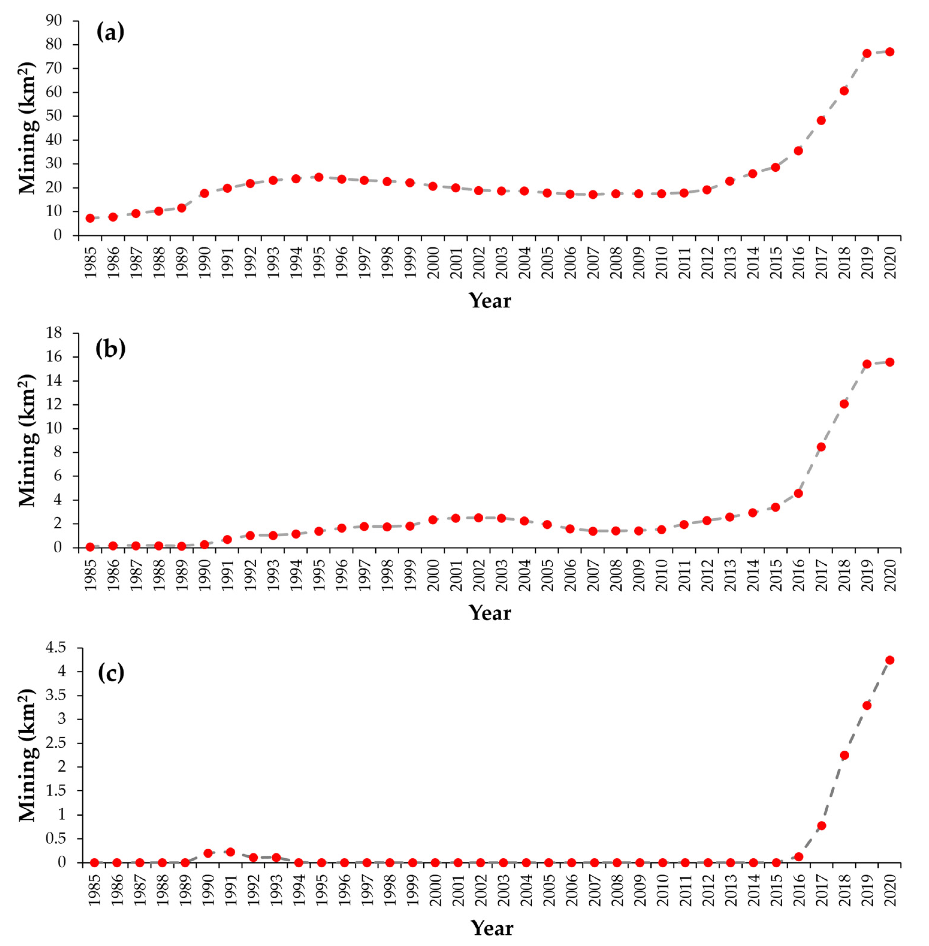
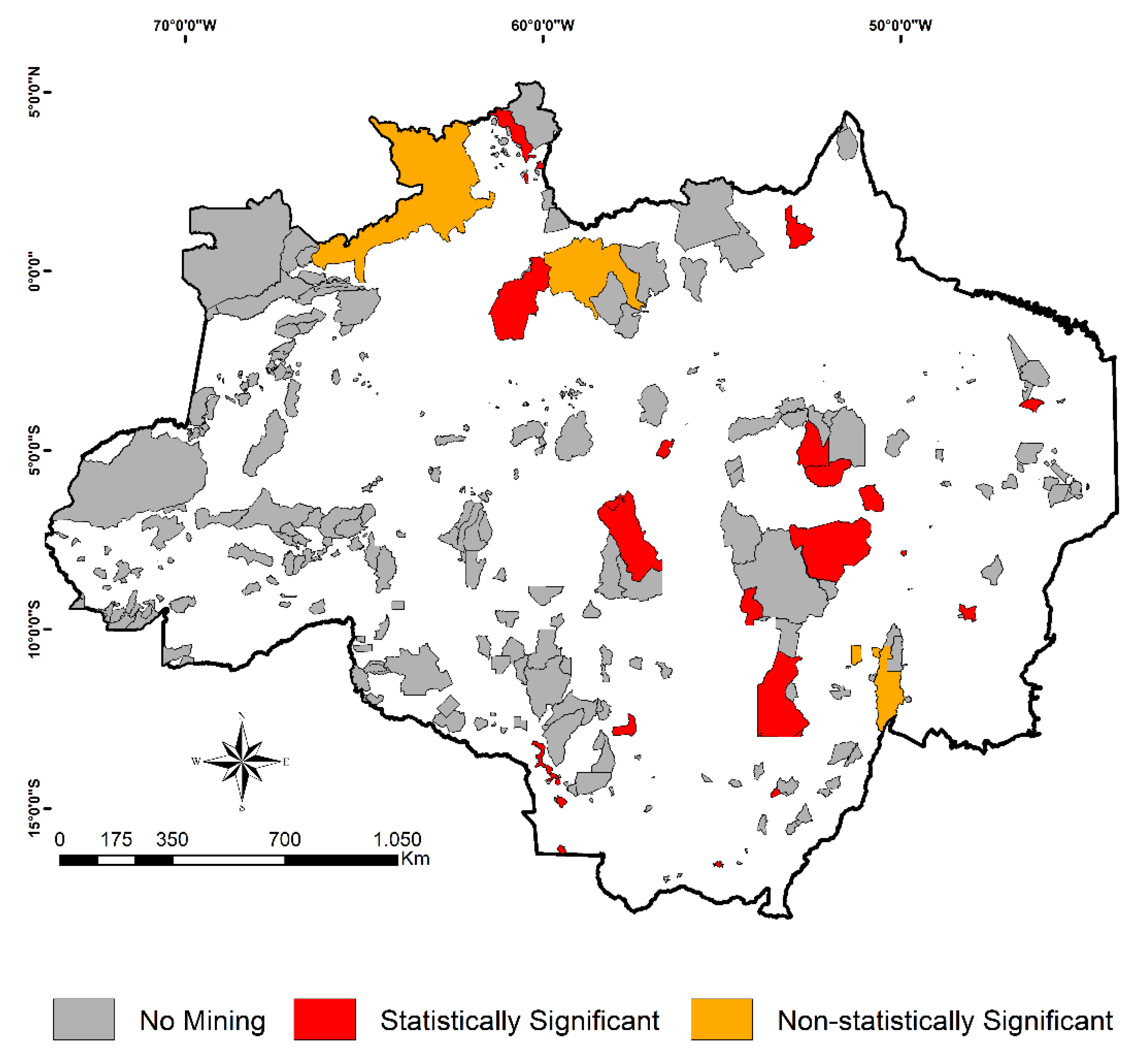
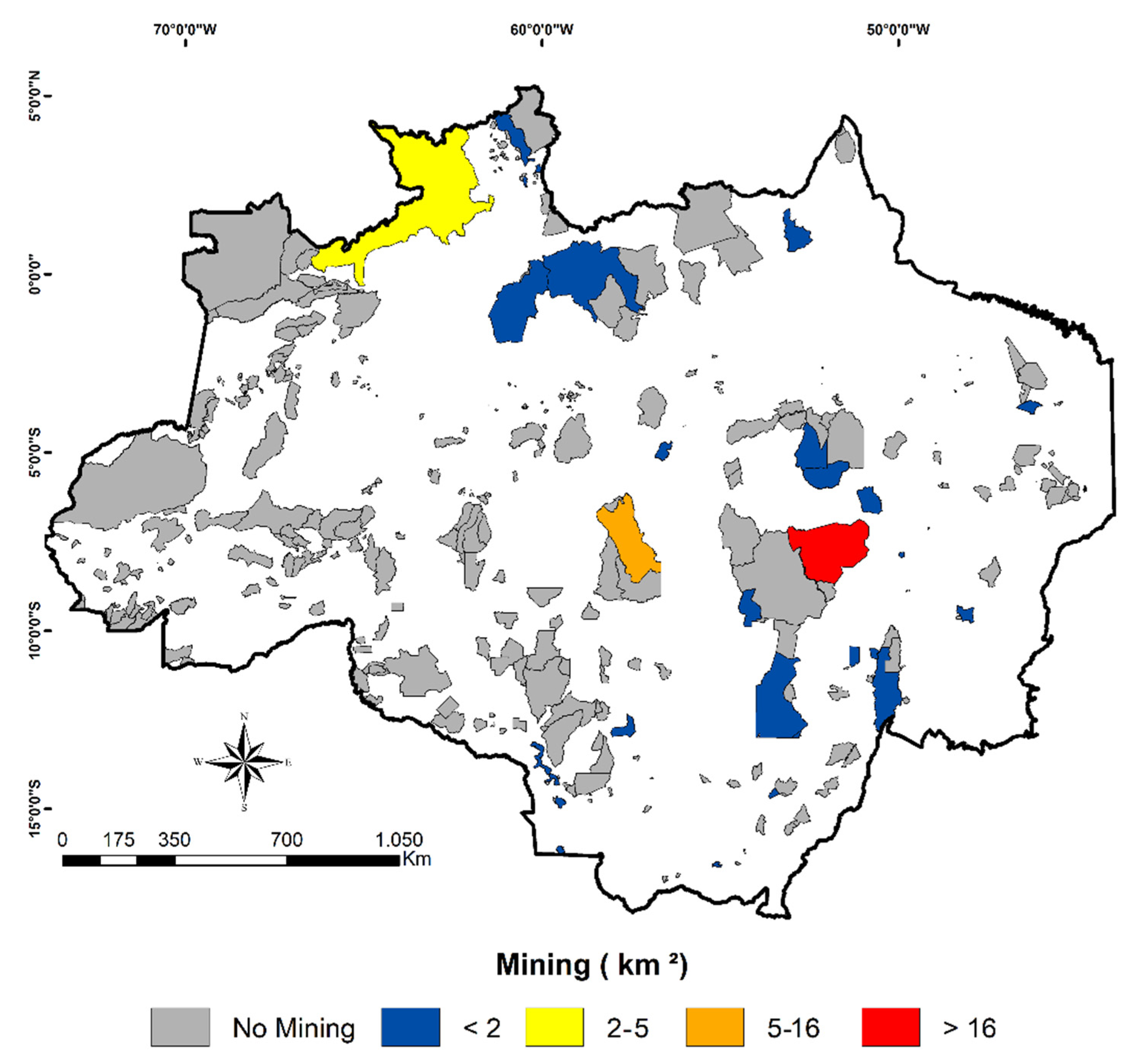
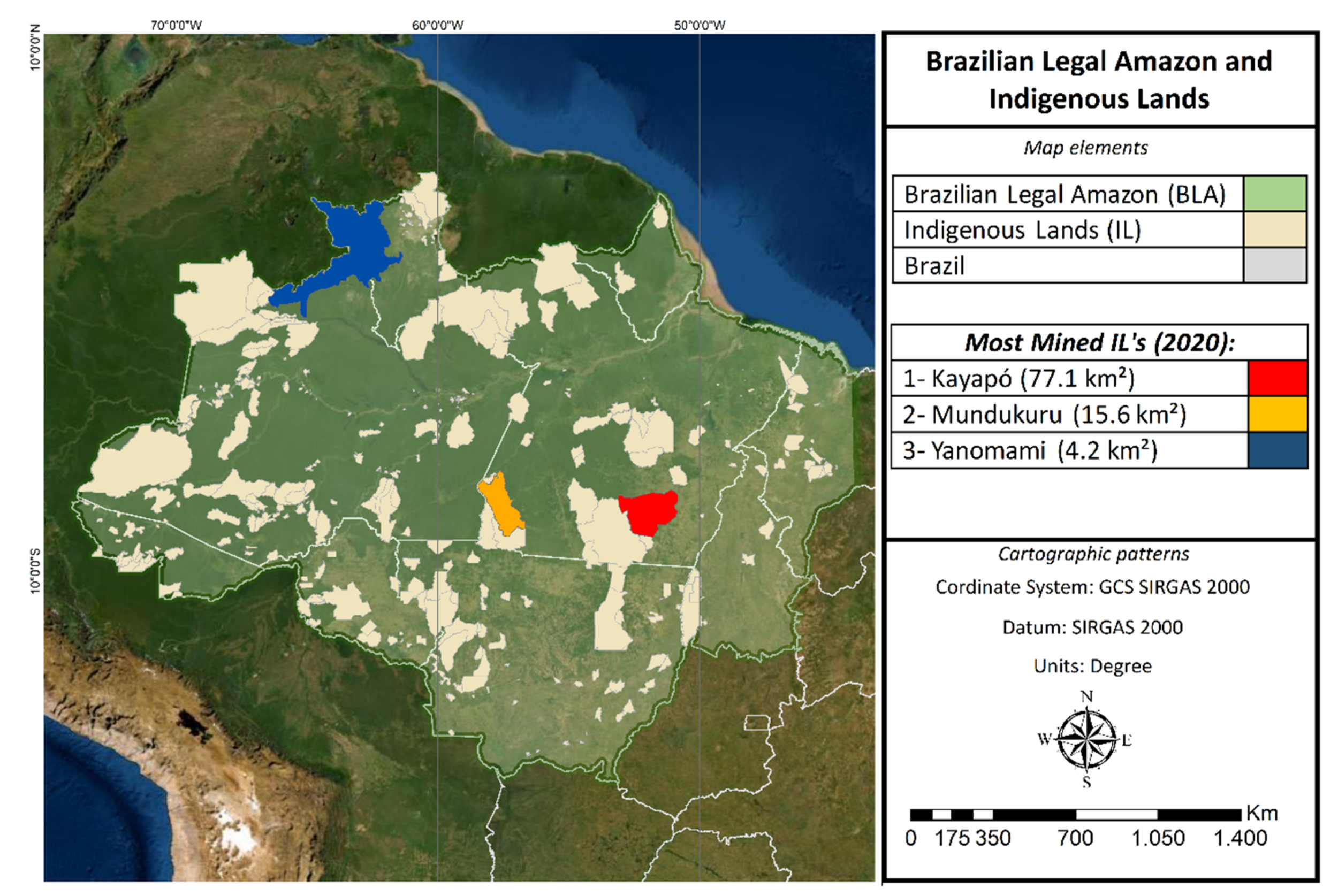
Following the 1985–2020 time series, we also detected trends in the mining activity within the ILs of the BLA. To this end, we applied the non-parametric Mann–Kendall trend test [45,46], which enables the determination of whether a trend exists in a time series. This test has been successfully applied in similar studies [47,48,49,50]. The Mann–Kendall test was applied to all of the 31 ILs of the BLA where mining activity was detected in at least one of 36 years analyzed. The null hypothesis of the test considered that there was no trend in the time series, whereas the alternative hypothesis considered that there was a trend present in the time series. If the p-value was lower than the significance level of 5%, the null hypothesis was rejected, and, therefore, there was statistically significant evidence that the time series had a trend.

3. Results

Figure 2 shows the total area classified as mining by MapBiomas within ILs of the BLA from 1985 to 2020. Mining areas were identified in all years of the 1985–2020 time series. We observe a steady growth of this activity over time, which has been exacerbated since 2017. The lowest estimate was identified at the beginning of the time series (year 1985, 7.45 km2), whereas the highest one was found in 2020 (102.16 km2). According to the Mann–Kendall test, the increasing trend in the 1985–2020 time series of the mining activity within all ILs of the BLA is statistically significant (p-value < 0.05).
Considering the most recent year of the time series (the year 2020), three ILs concentrated 95% of the mining activity within these protected areas of the BLA. These are the Kayapó (77.1 km2), Mundurukú (15.6 km2), and Yanomami (4.2 km2) ILs (Figure 1). We identified mining activity in the most critical IL (Kayapó) since the beginning of the 1985–2020 time series, where the estimate in 2020 (77.1 km2) was almost 1000% higher than the one found during the first year of the time series (7.2 km2). At the Mundurukú IL, mining activity rose sharply after 2016, jumping from 4.6 km2 to 15.6 km2 in only 5 years. The same pattern was found at the Yanomami IL, where mining activity rose from 0.1 km2 in 2016 to 4.2 km2 in 2020. These results are highlighted in Figure 3. Moreover, the majority of mining activity within ILs of the BLA was related to gold mining (99.5%), but tin mining was also identified (0.5%).
The analysis of Figure 4 shows that 25 of the 31 ILs of the BLA where mining activity was detected in at least one of 36 years analyzed (~81% of them) had a statistically significant increasing trend according to the Mann–Kendall test at 5%. This result highlights the fact that mining is a growing threat within the ILs of the BLA. The Yanomami IL, the third one with more mining activity in 2020, had no statistically significant increasing trend. This is because the IL is a new mining frontier, where mining activity was detected starting in 2016.
Figure 5 shows the spatial distribution of the mining activity within ILs of the BLA in 2020, the most recent and critical year of the time series analyzed. From the 385 ILs of the BLA, 356 of them had no mining activity in 2020. In 26 of them, the mining area was less than 2 km2. As discussed above, the remaining ones are the Yanomami (4.2 km2), Mundurukú (15.6 km2), and Kayapó (77.1 km2) ILs. Moreover, we may also observe that the mining activity in 2020 is not confined to the “Arc of Deforestation” region (eastern and central flanks of the BLA). It is also taking place in the northern flank, which comprises a significant portion of the BLA remaining forests.

4. Discussion

The increase in the BLA deforestation rates in recent years is not confined to unprotected areas but is also occurring within protected areas, such as ILs. Other ARDs support this result. According to the PRODES program, the Brazilian official program that has annually estimates deforestation rates within the BLA since 1988, the average deforestation increment in ILs from 2019 to 2021 (431 km2) is 65% above the average annual deforestation increment from 2008 to 2021 [13]. Mining-related deforestation contributes to this rise [21]. The DETER program [28], which uses coarser spatial resolution images than those used in the PRODES program to detect deforestation on a faster timescale to reveal emerging trends, facilitate inspections, and guide law enforcement actions to curb illegal deforestation in the BLA, identified 121.3 km2 of deforestation alerts related to mining in the BLA in 2021 [13]. This was the highest value since the beginning of the DETER program, 30.5% above the average of the 2017–2021 period. Still, according to DETER, mining-related deforestation within ILs in 2021 achieved 20.0 km2, an estimate 22.2% higher than the average of the 2017–2021 period [13]. Therefore, the statistically significant increasing trend in the mining activity within all ILs of the BLA and in 25 of the 31 ILs of the BLA where mining activity was detected in at least one of 36 years analyzed (Figure 4), identified between 1985 and 2020 using the MapBiomas LULC dataset collection 6, corroborates with other ARDs and is expected to increase in 2021, 2022, and the years following. This unfortunate scenario is also expected by Siqueira-Gay and Sánchez (2021) [21].
The increase in illegal mining activities in the BLA, such as the one within ILs, is highly related to the weakening of environmental policies in Brazil over recent years. Examples of this weakening are: (i) the undermining of the Brazilian Forest Code (BFC); (ii) bills moving in the Brazilian Parliament that will possibly lead to the decriminalization of the illegal occupation on public lands such as the ILs (e.g., PL-2633/2020, and PL-510/2021); (iii) a recent bill that proposes the regularization of mining within ILs (PL-191/2020); and (iv) the easing of environmental licensing. The relaxation of the Brazilian environmental policy may directly motivate illegal activities, including land grabbing and mining, creating social conflicts and violent episodes between the traditional Amazonians and those involved in these illegal activities. The interruption of initiatives that successfully decreased illegal activities in the BLA in the past, such as the Action Plan for Prevention and Control of Deforestation (PPCDAm) [51], also contributes to this scenario. Therefore, there is an urgent need to: (i) restore command and control policies to curb illegal deforestation [52,53]; (ii) improve successful market-derived initiatives against products from illegally deforested areas, such as the Soy Moratorium [54]; (iii) promote environmental awareness via social media platforms [55] and environmental education activities [56]; and (iv) finance forest economy activities [57]. These four axes are paramount to the conservation of the largest tropical forest in the world and the traditional peoples’ territories.
Although tin mining was also identified, more than 99% of the mining activity within ILs of the BLA in 2020 was related to gold extraction. Illegal gold mining in the BLA has expanded recently due to the increasing gold prices and the relaxation of the Brazilian environmental policy [21]. One of the major disturbances related to gold extraction in the BLA is the contamination of the terrestrial and aquatic ecosystems by mercury, which is traditionally used to separate and extract gold from rocks or sand [58,59,60]. This contamination can occur far beyond the mining sites, endangering the entire BLA. Consequently, mercury contamination also affects, directly or indirectly, the health [61] of both traditional peoples and other inhabitants of the BLA [62]. For example, high levels of mercury exposure were found in indigenous communities of the Mundurukú IL [63], the second IL with more mining activity found in our study. At the Yanomami IL, an increase of 8600% in the contamination by mercury at the Couto de Magalhães, Catrimani, Paríma, and Uraricoera rivers was recently identified [64]. In another perspective, smoke pollution from deforestation fires within ILs, which are often related to illegal mining, is of great concern to the indigenous peoples of the BLA, especially the isolated ones [65].
As discussed so far, the recent growing demand for minerals is increasing the pressure to open ILs and other protected areas for mining [66]. However, this is a longer-term process that started in the 1980s (Figure 2 and Figure 3). Based on the MapBiomas dataset, we identified mining activity at the Kayapó and Mundurukú ILs, two of the ILs presenting more mining activity in the BLA in 2020 (Figure 3 and Figure 5), before their legal demarcation in 1991 and 2004, respectively. Therefore, the demarcation process was not enough to cease illegal mining activities in these ILs, enabling the conclusion that law enforcement actions and effective monitoring are necessary to guarantee the role of ILs in protecting BLA remaining forests and the traditional peoples. Located at the agricultural frontier between the Pará and Mato Grosso States and crossed, respectively, by the Tapajós and Xingu rivers, the Kayapó and Mundurukú ILs are often targeted by invaders, whereas the indigenous peoples inhabiting them have a long history of resistance and have been combating illegal deforestation and mining since the 1980s [67]. Moreover, the Kayapó and Mundurukú ILs are inserted in the region known as the “Arc of Deforestation”. In this region, the remaining forests suffer a greater pressure from anthropogenic activities such as land conversion to agricultural expansion, although most of the already-cleared areas are degraded, underused, or abandoned [68]. The increasing threats associated with illegal mining within these ILs is leading to counteractions from their inhabitants. While having limited government protection at this moment, they are organizing themselves to patrol the ILs, risking their own lives when destroying bridges and removing machinery used by illegal miners [69]. Armed conflicts with garimpeiros have recently caused the murder of indigenous peoples that inhabited the ILs [70]. Simultaneously, this situation triggers tensions within the indigenous society since there are indigenous peoples (especially among the Kayapós) favorable to the mining activity.
The Yanomami, on the other hand, is a much more isolated IL. This isolation hindered the access of illegal miners for a long time. However, the inflated gold prices and the weakened protection of the BLA stimulated investments in infrastructures for accessing this IL. Such a situation characterizes the Yanomami IL as a new mining frontier and explains the lack of statistical significance in the increasing trend of the mining activity in this IL (Figure 4). In 2018, mining activity surpassed 2 km2 at the Yanomami IL for the first time (Figure 3). Since then, the exponential increment of this illegality has brought the worst scenario regarding invasions and human rights violations since the IL legal demarcation. In 2022, the Brazilian Federal Police identified an increase of 505% in mining at the margins of the Uraricoera river [64]. The Yanomami leaders estimate the presence of above 20,000 illegal miners within the IL, whereas the total number of indigenous is nearly 30,000 [71]. Moreover, the presence of garimpeiros has expanded malaria cases and has spread other infectious diseases to the indigenous peoples [72].
The identification of mining spots in ILs is key to their conservation. Although the mining activity is small in most of the ILs of the BLA, it can grow if not counteracted now. Datasets such as those offered by MapBiomas, and the PRODES and DETER programs, are potential tools for identifying mining hotspots and guiding law enforcement actions to curb this illegal activity. Nevertheless, a portion of the mining activity in the BLA is artisanal or onboard dredge rafts. Therefore, they are not identified by the datasets used in this study. Consequently, the mining activity in ILs in 2020 was very likely to be greater than 102.16 km2.

5. Conclusions

ILs and other protected areas are paramount for the conservation of the BLA remaining forests, the traditional livelihood of the Amazonians, and their well-being. The increasing pressure related to mining and its consequences endanger the critical role of ILs in maintaining Amazonia’s stability, but this scenario can be reversed. This could be achievable by strengthening environmental laws, adequately monitoring and enforcing the law in protected areas, and spreading the word about the importance of standing forests locally, regionally, and globally. All of these steps depend on political good will. As discussed here, the demarcation of ILs is not enough and much more is necessary for their prosperity.
The remote-sensing-based datasets used or cited in this study (MapBiomas annual LULC maps, PRODES annual deforestation estimates, and DETER deforestation alerts) enable monitoring the current status of ILs, and the identification of emerging trends related to illegal activities in these protected areas. Therefore, they are critical tools for legal authorities. More specifically, based on the abovementioned datasets, special attention must be paid to the Kayapó, Mundurukú, and Yanomami ILs. These are currently the most critical ILs of the BLA regarding illegal mining.

Author Contributions

Conceptualization, G.M., J.G., M.C. and E.V.E.-S.; methodology, G.M. and J.G.; writing—original draft preparation, G.M., J.G., M.C. and E.V.E.-S.; writing—review and editing, K.C. and G.d.O. All authors have read and agreed to the published version of the manuscript.

Funding

G.M., M.C., and E.V.E-S. thank the São Paulo Research Foundation (FAPESP, grants 2019/25701-8, 2021/07382-2, and 2021/11435-4, respectively). J.G. thanks the National Council for Scientific and Technological Development (CNPq, grant 380656/2022-1).

Data Availability Statement

All data used in this study are freely available and properly cited where applicable.

Conflicts of Interest

The authors declare no conflict of interest.

References

  1. Malhi, Y.; Gardner, T.A.; Goldsmith, G.R.; Silman, M.R.; Zelazowski, P. Tropical Forests in the Anthropocene. Annu. Rev. Environ. Resour. 2014, 39, 125–159. [Google Scholar] [CrossRef]
  2. Watson, J.E.M.; Evans, T.; Venter, O.; Williams, B.; Tulloch, A.; Stewart, C.; Thompson, I.; Ray, J.C.; Murray, K.; Salazar, A.; et al. The exceptional value of intact forest ecosystems. Nat. Ecol. Evol. 2018, 2, 599–610. [Google Scholar] [CrossRef] [PubMed]
  3. Brandon, K. Ecosystem Services from Tropical Forests: Review of Current Science. SSRN Electron. J. 2014, 380. [Google Scholar] [CrossRef]
  4. Gatti, L.V.; Basso, L.S.; Miller, J.B.; Gloor, M.; Gatti Domingues, L.; Cassol, H.L.G.; Tejada, G.; Aragao, L.; Nobre, C.; Peters, W.; et al. Amazonia as a carbon source linked to deforestation and climate change. Nature 2021, 595, 388–393. [Google Scholar] [CrossRef] [PubMed]
  5. Barlow, J.; Berenguer, E.; Carmenta, R.; Franca, F. Clarifying Amazonia’s burning crisis. Glob. Chang. Biol. 2020, 26, 319–321. [Google Scholar] [CrossRef]
  6. Bullock, E.L.; Woodcock, C.E.; Souza, C., Jr.; Olofsson, P. Satellite-based estimates reveal widespread forest degradation in the Amazon. Glob. Chang. Biol. 2020, 26, 2956–2969. [Google Scholar] [CrossRef]
  7. de Oliveira, G.; Brunsell, N.A.; Chen, J.M.; Shimabukuro, Y.E.; Mataveli, G.A.V.; dos Santos, C.A.C.; Stark, S.C.; de Lima, A.; Aragao, L.E.O.C. Legacy Effects Following Fire on Surface Energy, Water and Carbon Fluxes in Mature Amazonian Forests. J. Geophys. Res. Biogeosci. 2021, 126, e2020JG005833. [Google Scholar] [CrossRef]
  8. van der Werf, G.R.; Randerson, J.T.; Giglio, L.; van Leeuwen, T.T.; Chen, Y.; Rogers, B.M.; Mu, M.; van Marle, M.J.E.; Morton, D.C.; Collatz, G.J.; et al. Global fire emissions estimates during 1997–2016. Earth Syst. Sci. Data 2017, 9, 697–720. [Google Scholar] [CrossRef]
  9. Amaral, S.S.; Costa, M.A.M.; Soares Neto, T.G.; Costa, M.P.; Dias, F.F.; Anselmo, E.; Santos, J.C.D.; Carvalho, J.A., Jr. CO2, CO, hydrocarbon gases and PM2.5 emissions on dry season by deforestation fires in the Brazilian Amazonia. Environ. Pollut. 2019, 249, 311–320. [Google Scholar] [CrossRef]
  10. Federative Republic of Brazil. Constitution of the Federative Republic of Brazil. Available online: http://www2.senado.leg.br/bdsf/bitstream/handle/id/518231/CF88_Livro_EC91_2016.pdf (accessed on 2 June 2022).
  11. Escobar, H. Brazil’s deforestation is exploding—And 2020 will be worse. Science 2019, 22. [Google Scholar] [CrossRef]
  12. Vale, M.M.; Berenguer, E.; Argollo de Menezes, M.; Viveiros de Castro, E.B.; Pugliese de Siqueira, L.; Portela, R.C.Q. The COVID-19 pandemic as an opportunity to weaken environmental protection in Brazil. Biol. Conserv. 2021, 255, 108994. [Google Scholar] [CrossRef]
  13. National Institute for Space Research (INPE). Monitoring of the Brazilian Amazon Deforestation by Satellite. Available online: http://terrabrasilis.dpi.inpe.br/app/dashboard/deforestation/biomes/legal_amazon/rates (accessed on 31 May 2022).
  14. Amigo, I. Indigenous communities in Brazil fear pandemic’s impact. Science 2020, 368, 352. [Google Scholar] [CrossRef] [PubMed]
  15. Conceição, K.V.; Chaves, M.E.D.; Picoli, M.C.A.; Sánchez, A.H.; Soares, A.R.; Mataveli, G.A.V.; Silva, D.E.; Costa, J.S.; Camara, G. Government policies endanger the indigenous peoples of the Brazilian Amazon. Land Use Policy 2021, 108, 105663. [Google Scholar] [CrossRef]
  16. Rorato, A.C.; Picoli, M.C.A.; Verstegen, J.A.; Camara, G.; Silva Bezerra, F.G.; Escada, M.I.S. Environmental Threats over Amazonian Indigenous Lands. Land 2021, 10, 267. [Google Scholar] [CrossRef]
  17. Mataveli, G.; de Oliveira, G. Protect the Amazon’s Indigenous lands. Science 2022, 375, 275–276. [Google Scholar] [CrossRef]
  18. Ferrante, L.; Fearnside, P.M. Brazilian government violates Indigenous rights: What could induce a change? J. Geogr. Soc. Berl. 2021, 152, 200–211. [Google Scholar] [CrossRef]
  19. Villén-Pérez, S.; Anaya-Valenzuela, L.; Conrado da Cruz, D.; Fearnside, P.M. Mining threatens isolated indigenous peoples in the Brazilian Amazon. Glob. Environ. Change 2022, 72, 102398. [Google Scholar] [CrossRef]
  20. Neves, R. Pedidos de mineração Atingem Mais de 200 Terras Indígenas na Amazônia. Available online: http://noticias.uol.com.br/meio-ambiente/ultimas-noticias/redacao/2022/03/13/pedidos-de-mineracao-atingem-4-em-cada-10-terras-indigenas-no-brasil.htm (accessed on 7 June 2022).
  21. Siqueira-Gay, J.; Sánchez, L.E. The outbreak of illegal gold mining in the Brazilian Amazon boosts deforestation. Reg. Environ. Change 2021, 21, 28. [Google Scholar] [CrossRef]
  22. Begotti, R.A.; Peres, C.A. Rapidly escalating threats to the biodiversity and ethnocultural capital of Brazilian Indigenous Lands. Land Use Policy 2020, 96, 104694. [Google Scholar] [CrossRef]
  23. Bratman, E.; Dias, C.B. Development blind spots and environmental impact assessment: Tensions between policy, law and practice in Brazil’s Xingu river basin. Environ. Impact Assess. Rev. 2018, 70, 1–10. [Google Scholar] [CrossRef]
  24. Siqueira-Gay, J.; Soares-Filho, B.; Sanchez, L.E.; Oviedo, A.; Sonter, L.J. Proposed Legislation to Mine Brazil’s Indigenous Lands Will Threaten Amazon Forests and Their Valuable Ecosystem Services. One Earth 2020, 3, 356–362. [Google Scholar] [CrossRef] [PubMed]
  25. Federative Republic of Brazil. Confira a Íntegra do Discurso do Ministro Joaquim Leite na Plenária da Cúpula do Clima. Available online: http://www.gov.br/mma/pt-br/noticias/confira-a-integra-do-discurso-do-ministro-joaquim-leite-na-plenaria-da-cupula-do-clima (accessed on 2 June 2022).
  26. International Labour Organization (ILO). ILO Indigenous and Tribal Peoples Convention (No. 169). Available online: http://www.ilo.org/dyn/normlex/en/f?p=NORMLEXPUB:12100:0::NO:12100:P12100_INSTRUMENT_ID:312314:NO (accessed on 4 June 2022).
  27. MapBiomas. Project MapBiomas—Collection 6.0 of Brazilian Land Cover & Use Map Series. Available online: http://mapbiomas.org/en (accessed on 1 June 2022).
  28. Diniz, C.G.; Souza, A.A.d.A.; Santos, D.C.; Dias, M.C.; Luz, N.C.d.; Moraes, D.R.V.d.; Maia, J.S.A.; Gomes, A.R.; Narvaes, I.d.S.; Valeriano, D.M.; et al. DETER-B: The New Amazon Near Real-Time Deforestation Detection System. IEEE J. Sel. Top. Appl. Earth Obs. Remote Sens. 2015, 8, 3619–3628. [Google Scholar] [CrossRef]
  29. Paiva, P.F.P.R.; de Lourdes Pinheiro Ruivo, M.; da Silva Júnior, O.M.; de Nazaré Martins Maciel, M.; Braga, T.G.M.; de Andrade, M.M.N.; dos Santos Junior, P.C.; da Rocha, E.S.; de Freitas, T.P.M.; da Silva Leite, T.V.; et al. Deforestation in protect areas in the Amazon: A threat to biodiversity. Biodivers. Conserv. 2019, 29, 19–38. [Google Scholar] [CrossRef]
  30. Fuller, C.; Ondei, S.; Brook, B.W.; Buettel, J.C. Protected-area planning in the Brazilian Amazon should prioritize additionality and permanence, not leakage mitigation. Biol. Conserv. 2020, 248, 108673. [Google Scholar] [CrossRef]
  31. Rorato, A.C.; Camara, G.; Escada, M.I.S.; Picoli, M.C.A.; Moreira, T.; Verstegen, J.A. Brazilian amazon indigenous peoples threatened by mining bill. Environ. Res. Lett. 2020, 15, 1040a3. [Google Scholar] [CrossRef]
  32. Indigenous Lands of Brazil. Yanomami Indigenous Land. Available online: http://terrasindigenas.org.br/en/terras-indigenas/4016 (accessed on 1 June 2022).
  33. Indigenous Lands of Brazil. Mundurukú Indigenous Land. Available online: http://terrasindigenas.org.br/en/terras-indigenas/3770 (accessed on 1 June 2022).
  34. Indigenous Lands of Brazil. Kayapó Indigenous Land. Available online: http://terrasindigenas.org.br/en/terras-indigenas/3731 (accessed on 1 June 2022).
  35. Nunes, S.; Oliveira, L.; Siqueira, J.; Morton, D.C.; Souza, C.M. Unmasking secondary vegetation dynamics in the Brazilian Amazon. Environ. Res. Lett. 2020, 15, 034057. [Google Scholar] [CrossRef]
  36. Silva Junior, C.H.L.; Heinrich, V.H.A.; Freire, A.T.G.; Broggio, I.S.; Rosan, T.M.; Doblas, J.; Anderson, L.O.; Rousseau, G.X.; Shimabukuro, Y.E.; Silva, C.A.; et al. Benchmark maps of 33 years of secondary forest age for Brazil. Sci. Data 2020, 7, 269. [Google Scholar] [CrossRef]
  37. Silva Junior, C.H.L.; Celentano, D.; Rousseau, G.X.; de Moura, E.G.; Varga, I.v.D.; Martinez, C.; Martins, M.B. Amazon forest on the edge of collapse in the Maranhão State, Brazil. Land Use Policy 2020, 97, 104806. [Google Scholar] [CrossRef]
  38. Guerrero, J.V.R.; Escobar-Silva, E.V.; Chaves, M.E.D.; Mataveli, G.A.V.; Bourscheidt, V.; de Oliveira, G.; Picoli, M.C.A.; Shimabukuro, Y.E.; Moschini, L.E. Assessing Land Use and Land Cover Changes in the Direct Influence Zone of the Braço Norte Hydropower Complex, Brazilian Amazonia. Forests 2020, 11, 988. [Google Scholar] [CrossRef]
  39. Mataveli, G.A.V.; de Oliveira, G.; Seixas, H.T.; Pereira, G.; Stark, S.C.; Gatti, L.V.; Basso, L.S.; Tejada, G.; Cassol, H.L.G.; Anderson, L.O.; et al. Relationship between Biomass Burning Emissions and Deforestation in Amazonia over the Last Two Decades. Forests 2021, 12, 1217. [Google Scholar] [CrossRef]
  40. Bonanomi, J.; Tortato, F.R.; Gomes, R.d.S.R.; Penha, J.M.; Bueno, A.S.; Peres, C.A. Protecting forests at the expense of native grasslands: Land-use policy encourages open-habitat loss in the Brazilian cerrado biome. Perspect. Ecol. Conserv. 2019, 17, 26–31. [Google Scholar] [CrossRef]
  41. Souza, C.M.; Shimbo, J.Z.; Rosa, M.R.; Parente, L.L.; Alencar, A.A.; Rudorff, B.F.T.; Hasenack, H.; Matsumoto, M.; Ferreira, L.G.; Souza-Filho, P.W.M.; et al. Reconstructing Three Decades of Land Use and Land Cover Changes in Brazilian Biomes with Landsat Archive and Earth Engine. Remote Sens. 2020, 12, 2735. [Google Scholar] [CrossRef]
  42. MapBiomas. Project MapBiomas—Accuracy Assessment of Collection 6.0 Cover & Use Maps. Available online: http://mapbiomas.org/accuracy-statistics (accessed on 1 June 2022).
  43. Pontius, R.G.; Millones, M. Death to Kappa: Birth of quantity disagreement and allocation disagreement for accuracy assessment. Int. J. Remote Sens. 2011, 32, 4407–4429. [Google Scholar] [CrossRef]
  44. MapBiomas. Project MapBiomas—MapBiomas Collectin 6.0 Mining. Available online: http://mapbiomas.org/colecoes-mapbiomas-1?cama_set_language=pt-BR (accessed on 1 June 2022).
  45. Mann, H.B. Nonparametric Tests Against Trend. Econometrica 1945, 13, 245–259. [Google Scholar] [CrossRef]
  46. Kendall, M.G. Rank Correlation Methods; Charles Griffin: London, UK, 1955. [Google Scholar]
  47. Souza-Filho, P.W.; de Souza, E.B.; Silva Junior, R.O.; Nascimento, W.R., Jr.; Versiani de Mendonca, B.R.; Guimaraes, J.T.; Dall’Agnol, R.; Siqueira, J.O. Four decades of land-cover, land-use and hydroclimatology changes in the Itacaiunas River watershed, southeastern Amazon. J. Environ. Manage. 2016, 167, 175–184. [Google Scholar] [CrossRef]
  48. Cavalcante, R.B.L.; Pontes, P.R.M.; Souza-Filho, P.W.M.; Souza, E.B. Opposite Effects of Climate and Land Use Changes on the Annual Water Balance in the Amazon Arc of Deforestation. Water Resour. Res. 2019, 55, 3092–3106. [Google Scholar] [CrossRef]
  49. Liu, S.; Li, W.; Qiao, W.; Wang, Q.; Hu, Y.; Wang, Z. Effect of natural conditions and mining activities on vegetation variations in arid and semiarid mining regions. Ecol. Indic. 2019, 103, 331–345. [Google Scholar] [CrossRef]
  50. Carvalho, S.; Oliveira, A.; Pedersen, J.S.; Manhice, H.; Lisboa, F.; Norguet, J.; de Wit, F.; Santos, F.D. A changing Amazon rainforest: Historical trends and future projections under post-Paris climate scenarios. Glob. Planet. Change 2020, 195, 103328. [Google Scholar] [CrossRef]
  51. West, T.A.P.; Fearnside, P.M. Brazil’s conservation reform and the reduction of deforestation in Amazonia. Land Use Policy 2021, 100, 105072. [Google Scholar] [CrossRef]
  52. Trancoso, R. Changing Amazon deforestation patterns: Urgent need to restore command and control policies and market interventions. Environ. Res. Lett. 2021, 16, 041004. [Google Scholar] [CrossRef]
  53. Mataveli, G.; de Oliveira, G.; Chaves, M.E.D.; Dalagnol, R.; Wagner, F.H.; Ipia, A.H.S.; Silva-Junior, C.H.L.; Aragão, L.E.O.C. Science-based planning can support law enforcement actions to curb deforestation in the Brazilian Amazon. Conserv. Lett. 2022, e12908. [Google Scholar] [CrossRef]
  54. Heilmayr, R.; Rausch, L.L.; Munger, J.; Gibbs, H.K. Brazil’s Amazon Soy Moratorium reduced deforestation. Nat. Food 2020, 1, 801–810. [Google Scholar] [CrossRef]
  55. Caetano, M.A.L. Political activity in social media induces forest fires in the Brazilian Amazon. Technol. Forecast. Soc. Change 2021, 167, 120676. [Google Scholar] [CrossRef]
  56. Aragão, L.E.O.C.; Anderson, L.O.; Silva Junior, C.H.L. Brazil’s Challenge to Restrain Deforestation and Fires in the Amazon during COVID-19 Pandemic in 2020: Environmental, Social Implications and Their Governance. Available online: http://www.obt.inpe.br/OBT/noticias-obt-inpe/nota-tecnica-do-laboratorio-tress-obt-evidencia-a-possibilidade-de-sobreposicao-entre-queimadas-e-covid-19/nt_desmatamento_fogo_e_covid-19_na_amazonia-circulacao.pdf (accessed on 2 June 2022).
  57. Nobre, C.A.; Arieira, J.; Nascimento, N. Amazonian Forest: The Products of Agroecological Systems. Available online: http://publications.iadb.org/publications/english/document/Amazonian-Forest-The-Products-of-Agroecological-Systems-Considerations-about-the-Natural-Forest-and-Economic-Exploitation-for-its-Conservation-and-How-to-Develop-Sustainable-Agroforestry-Systems-that-Induce-the-Reduction-of-Deforestation.pdf (accessed on 1 June 2022).
  58. Veiga, M.M.; Hinton, J.J. Abandoned artisanal gold mines in the Brazilian Amazon: A legacy of mercury pollution. Nat. Resour. Forum 2002, 26, 15–26. [Google Scholar] [CrossRef]
  59. Bonotto, D.M.; Wijesiri, B.; Vergotti, M.; da Silveira, E.G.; Goonetilleke, A. Assessing mercury pollution in Amazon River tributaries using a Bayesian Network approach. Ecotoxicol. Environ. Saf. 2018, 166, 354–358. [Google Scholar] [CrossRef]
  60. Gerson, J.R.; Szponar, N.; Zambrano, A.A.; Bergquist, B.; Broadbent, E.; Driscoll, C.T.; Erkenswick, G.; Evers, D.C.; Fernandez, L.E.; Hsu-Kim, H.; et al. Amazon forests capture high levels of atmospheric mercury pollution from artisanal gold mining. Nat. Commun. 2022, 13, 559. [Google Scholar] [CrossRef]
  61. Passos, C.J.; Mergler, D. Human mercury exposure and adverse health effects in the Amazon: A review. Cad. Saude Publica 2008, 24, s503–s520. [Google Scholar] [CrossRef]
  62. Fernandez-Llamazares, A.; Garteizgogeascoa, M.; Basu, N.; Brondizio, E.S.; Cabeza, M.; Martinez-Alier, J.; McElwee, P.; Reyes-Garcia, V. A State-of-the-Art Review of Indigenous Peoples and Environmental Pollution. Integr. Environ. Assess. Manag. 2020, 16, 324–341. [Google Scholar] [CrossRef]
  63. Basta, P.C.; Viana, P.V.S.; Vasconcellos, A.C.S.; Perisse, A.R.S.; Hofer, C.B.; Paiva, N.S.; Kempton, J.W.; Ciampi de Andrade, D.; Oliveira, R.A.A.; Achatz, R.W.; et al. Mercury Exposure in Munduruku Indigenous Communities from Brazilian Amazon: Methodological Background and an Overview of the Principal Results. Int. J. Environ. Res. Public Health 2021, 18, 9222. [Google Scholar] [CrossRef]
  64. Ramalho, Y.; Oliveira, V.; Abreu, M.M. Rios na Terra Yanomami Têm 8600% de Contaminação por Mercúrio, Revela Laudo da PF. Available online: http://g1.globo.com/rr/roraima/noticia/2022/06/06/rios-na-terra-yanomami-tem-8600percent-de-contaminacao-por-mercurio-revela-laudo-da-pf.ghtml (accessed on 7 June 2022).
  65. de Oliveira, G.; Chen, J.M.; Stark, S.C.; Berenguer, E.; Moutinho, P.; Artaxo, P.; Anderson, L.O.; Aragao, L. Smoke pollution’s impacts in Amazonia. Science 2020, 369, 634–635. [Google Scholar] [CrossRef]
  66. Siqueira-Gay, J.; Metzger, J.P.; Sánchez, L.E.; Sonter, L.J. Strategic planning to mitigate mining impacts on protected areas in the Brazilian Amazon. Nat. Sustain. 2022. [Google Scholar] [CrossRef]
  67. Menton, M.; Milanez, F.; Souza, J.M.d.A.; Cruz, F.S.M. The COVID-19 pandemic intensified resource conflicts and indigenous resistance in Brazil. World Dev. 2021, 138, 105222. [Google Scholar] [CrossRef]
  68. Zero Deforestation Working Group. A Pathway to Zero Deforestation in the Brazilian Amazon. Available online: http://imazon.org.br/PDFimazon/Ingles/books/A%20Pathway%20to%20Zero%20Deforestation%20in%20the%20Brazilian%20Amazon.pdf (accessed on 2 June 2022).
  69. Camargos, D. Em Ofensiva Contra Indígenas no Pará, Garimpeiros Ilegais Movimentam Mercado Bilionário. Available online: http://reporterbrasil.org.br/2019/11/em-ofensiva-contra-indigenas-no-para-garimpeiros-ilegais-movimentam-mercado-bilionario/ (accessed on 7 June 2022).
  70. Marques, G.d.S. Terra, território e América Latina: O desafio de cultivar a esperança. Revista Katálysis 2021, 24, 439–442. [Google Scholar] [CrossRef]
  71. Conselho Indigenista Missionário (CIMI). Violência Contra os Povos Indígenas no Brasil. Available online: http://cimi.org.br/wp-content/uploads/2021/11/relatorio-violencia-povos-indigenas-2020-cimi.pdf (accessed on 5 June 2022).
  72. Hutukara Associação Yanomami; Associação Wanasseduume Ye’kwana. Yanomami Sob Ataque: Garimpo Ilegal na Terra Indígena Yanomami e Propostas Para Combatê-lo. Available online: http://acervo.socioambiental.org/acervo/documentos/yanomami-sob-ataque-garimpo-ilegal-na-terra-indigena-yanomami-e-propostas-para (accessed on 5 June 2022).
Figure 1. Location of the study area: the Indigenous Lands (ILs) within the Brazilian Legal Amazon (BLA). The three ILs that concentrated most of the mining activity in 2020 are represented by the red (Kayapó), yellow (Munduruku), and blue (Yanomami) colors.
Remotesensing 14 04092 g001
Figure 2. Total area (km2) classified as mining by the MapBiomas LULC dataset collection 6 from 1985 to 2020 within Indigenous Lands of the Brazilian Legal Amazon.
Remotesensing 14 04092 g002
Figure 3. Total area (km2) classified as mining by the MapBiomas LULC dataset collection 6 from 1985 to 2020 within the (a) Kayapó, (b) Mundurukú, and (c) Yanomami Indigenous Lands during the 1985–2020 period.
Remotesensing 14 04092 g003
Figure 4. Spatial distribution of the result obtained after applying the Mann–Kendall test to the mining activity time series of the 31 Indigenous Lands of the Brazilian Legal Amazon where mining activity was detected in at least one of 36 years analyzed.
Remotesensing 14 04092 g004
Figure 5. Spatial distribution of the areas classified as mining by the MapBiomas LULC dataset in 2020 within Indigenous Lands of the Brazilian Legal Amazon.
Remotesensing 14 04092 g005
Publisher’s Note: MDPI stays neutral with regard to jurisdictional claims in published maps and institutional affiliations.

