A Simple Method of Mapping Landslides Runout Zones Considering Kinematic Uncertainties
Abstract
:1. Introduction
2. Methods
2.1. Computational Approach
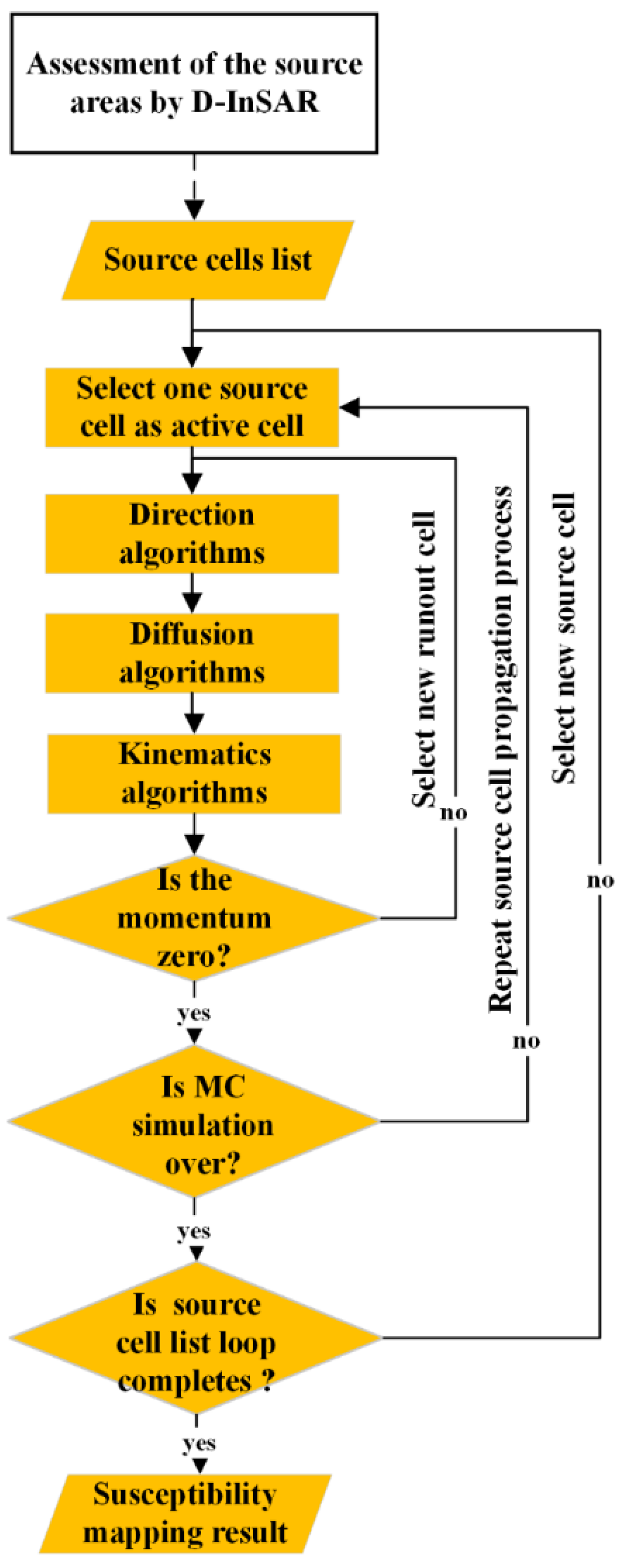
- The cells within the vector boundary in the landslide source area are marked as source cells, and each cell is taken into a propagation loop.
- The first source cell is marked as the first active cell. Then, the kinetic energy in the first active cell is calculated by energy conservation theory. If > 0, the cell in the propagation direction calculated by MC simulation is marked as the next active cell. The loop continues until ≤ 0.
- Each cell in the source cell list executes step 2 many times, which is determined by preset MC simulation iteration. When the active cell propagates to cell , 1 is added to in the arrival times matrix.
- Every cell in the source cell list executes steps 2 and 3, and an arrival times matrix is obtained. Finally, the susceptibility map is calculated by the method mentioned in the later section.
2.2. Theoretical Model
- 1.
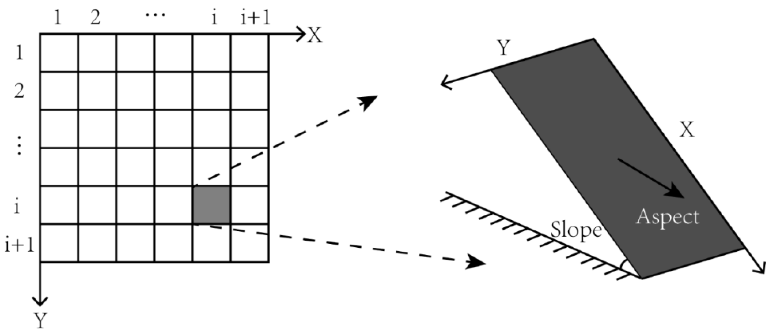
- Step 1: Establishment of coordinate systems in grid data
- 2.
- Step 2: Minimum energy trajectory calculation
- 3.
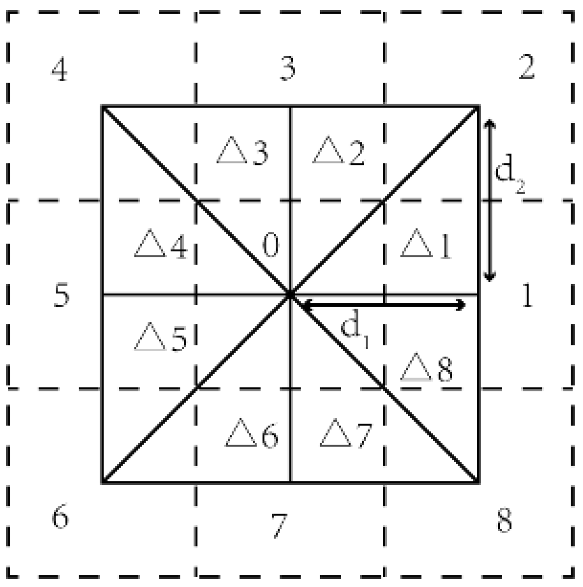
- Step 3: Selection of propagation path
- 4.
- Direction calculation
- 5.
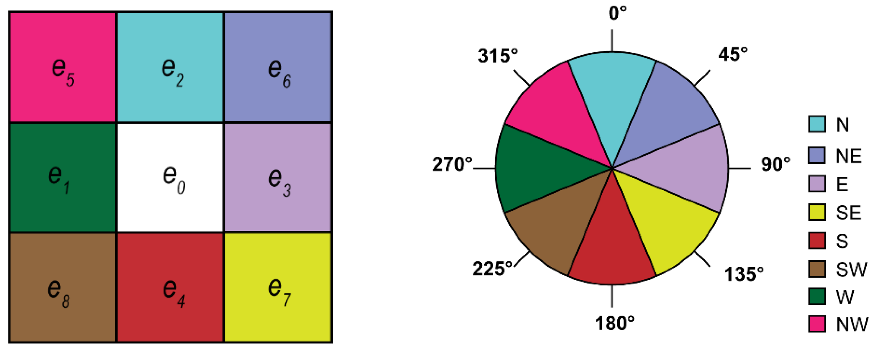
- D-infinity:
- 6.
- Aspect:
- 7.
- Diffusion calculation
- 8.
- Step 4: Hazardous zone analysis
3. Results
3.1. Case Study 1
3.2. Case Study 2
3.2.1. Assessment of Landslide Deformation Area by D-InSAR
3.2.2. D-InSAR Assessment Results
3.2.3. Landslide Runout Modeling
4. Discussion
4.1. Influence of the Elevation Model Resolution
4.2. Influence of the Diffusion Angle
4.3. The Suggested Parameter Setting Range
5. Conclusions
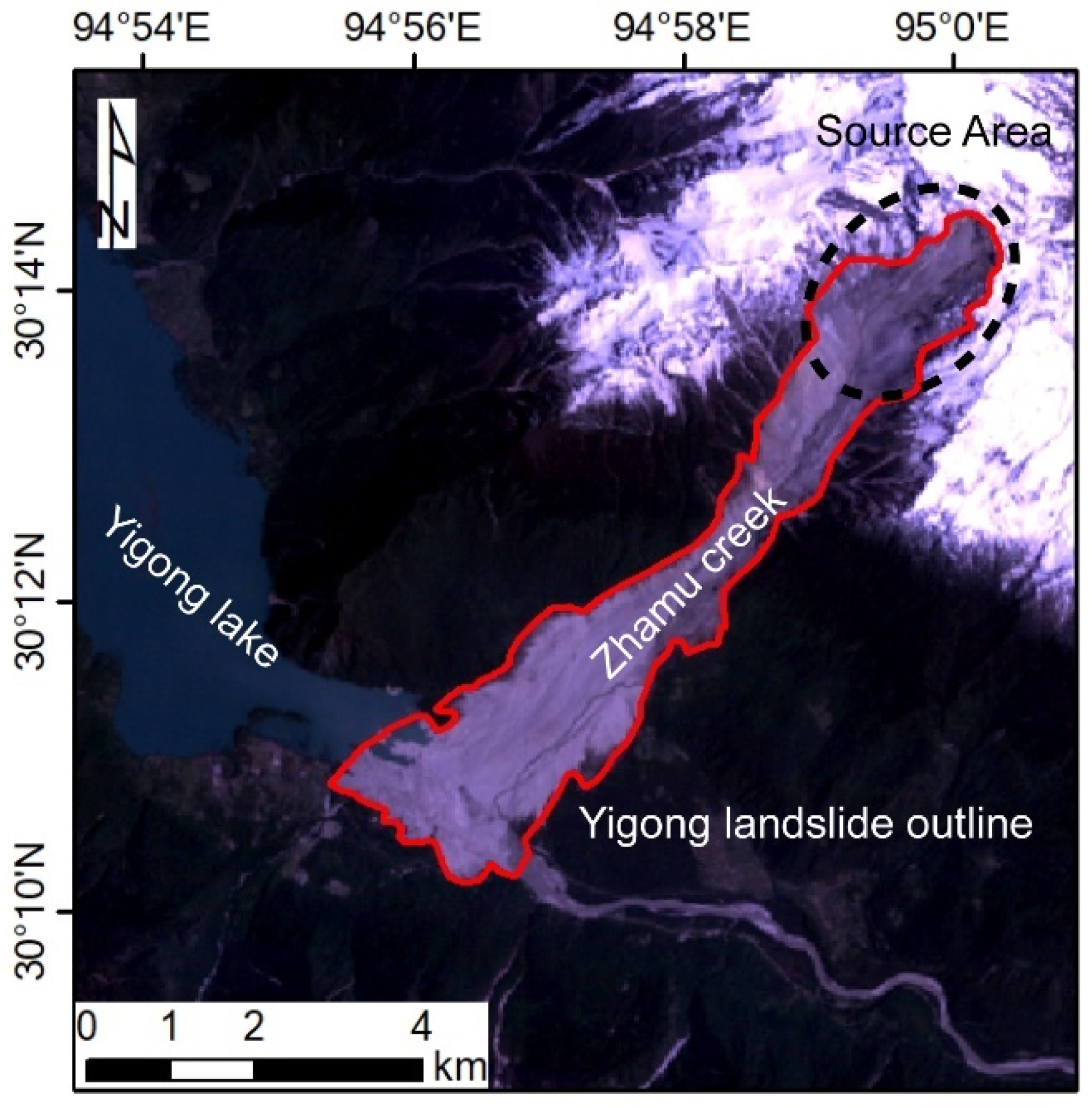
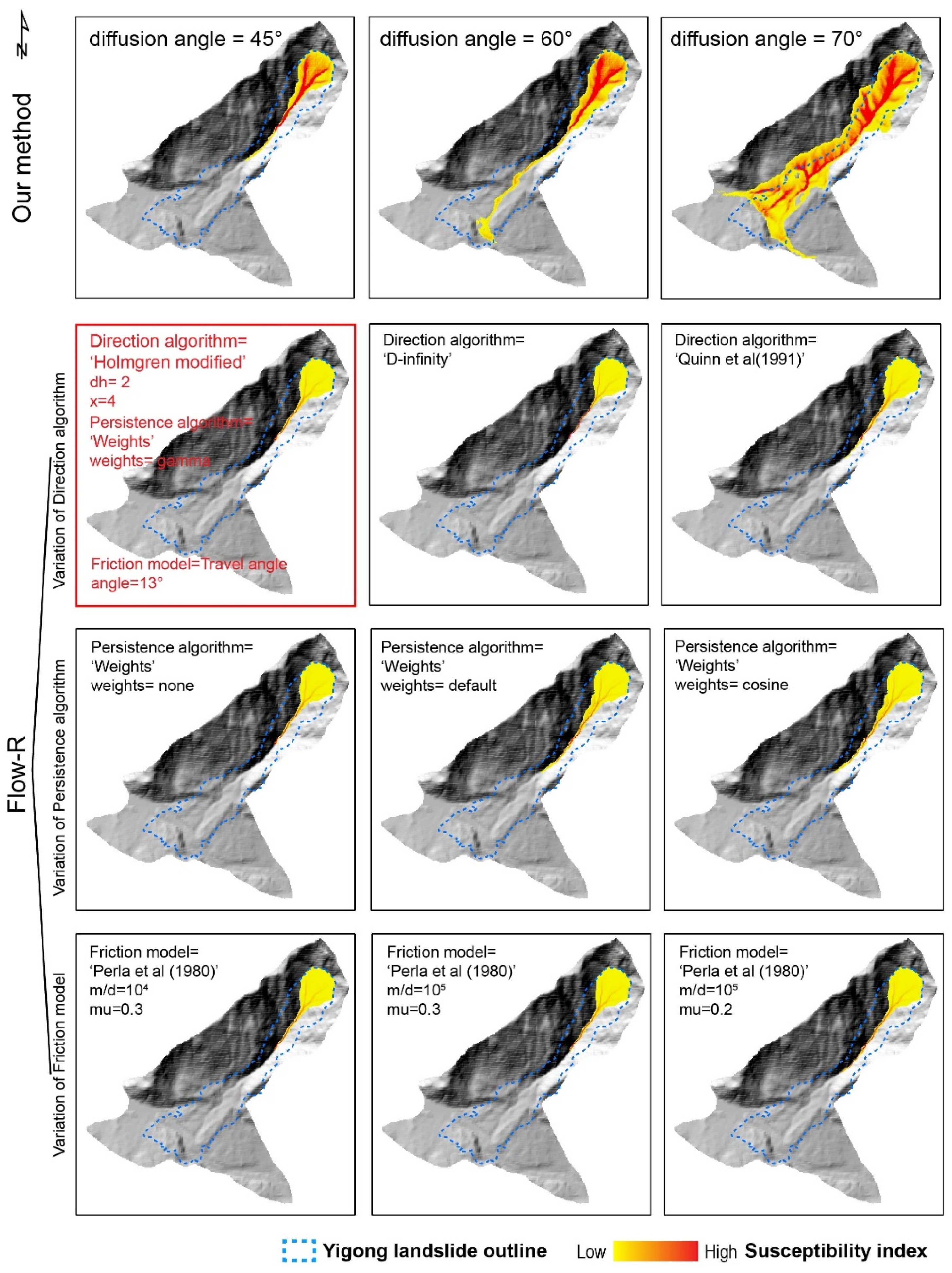
- Compared with other models of the same type, our method obtains a better Yigong landslide simulation result. The diffusion angle concept provides the possibility to express the uncertainty of landslide simulation in grid data and solves the false stops problem due to obstacles in the process of propagation.
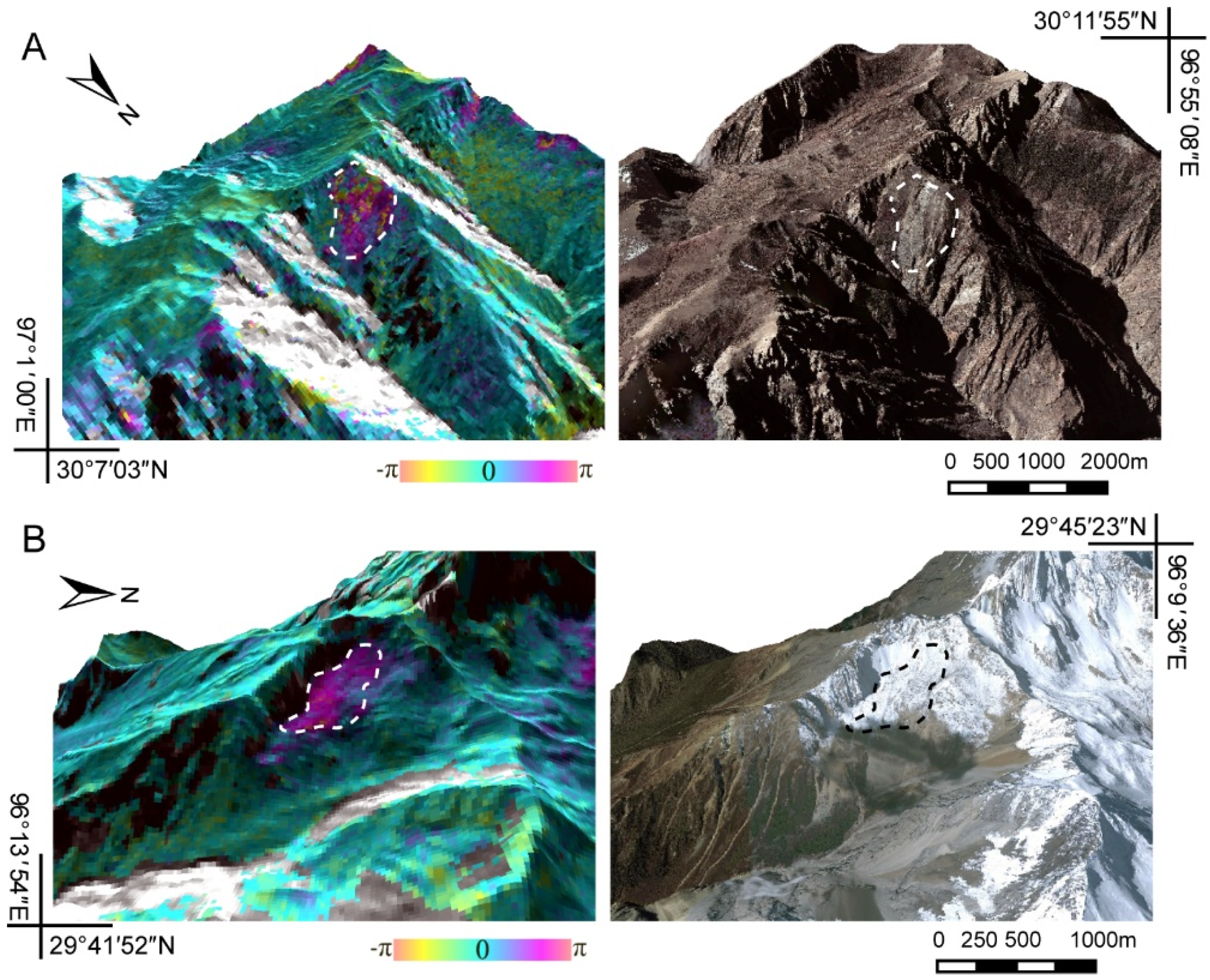
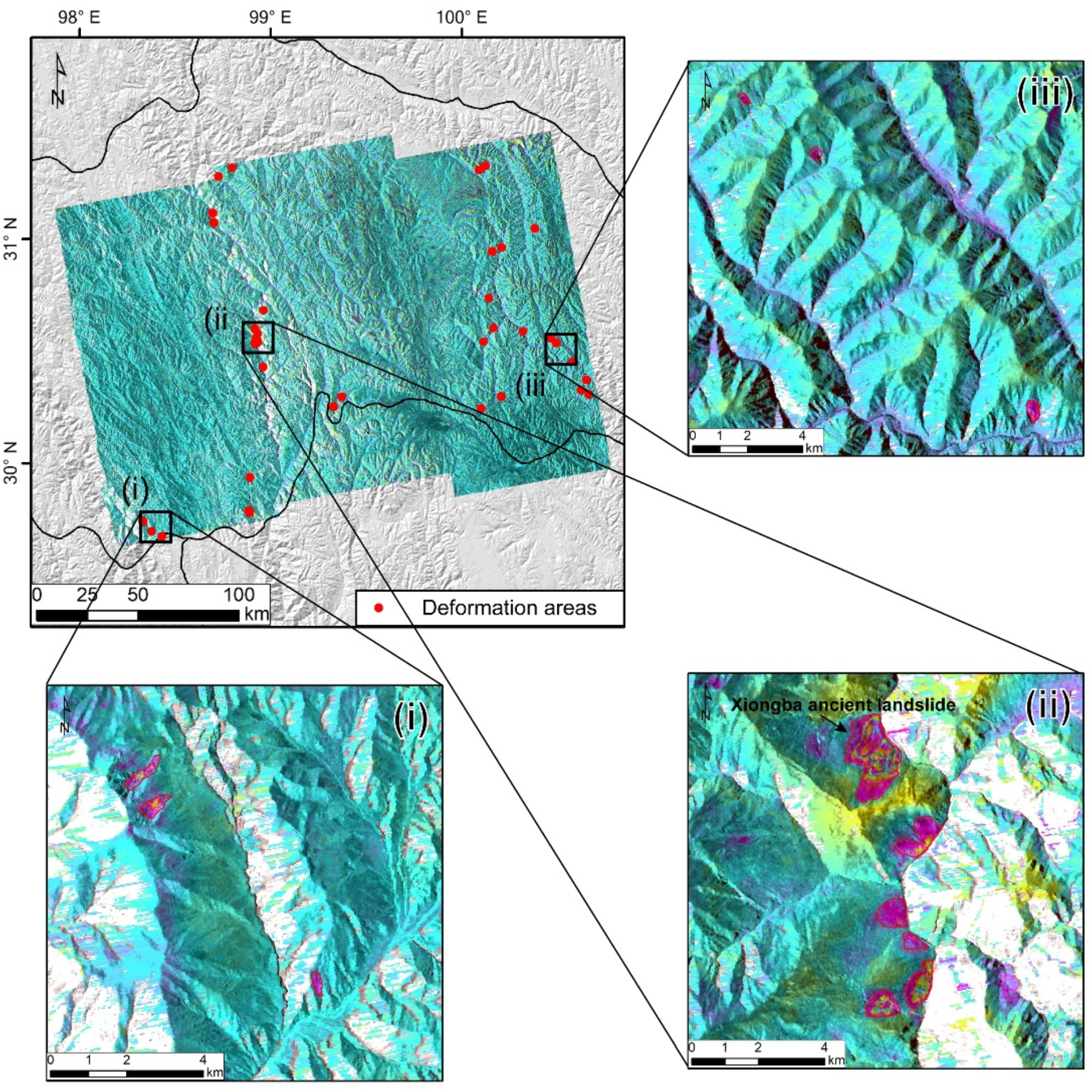
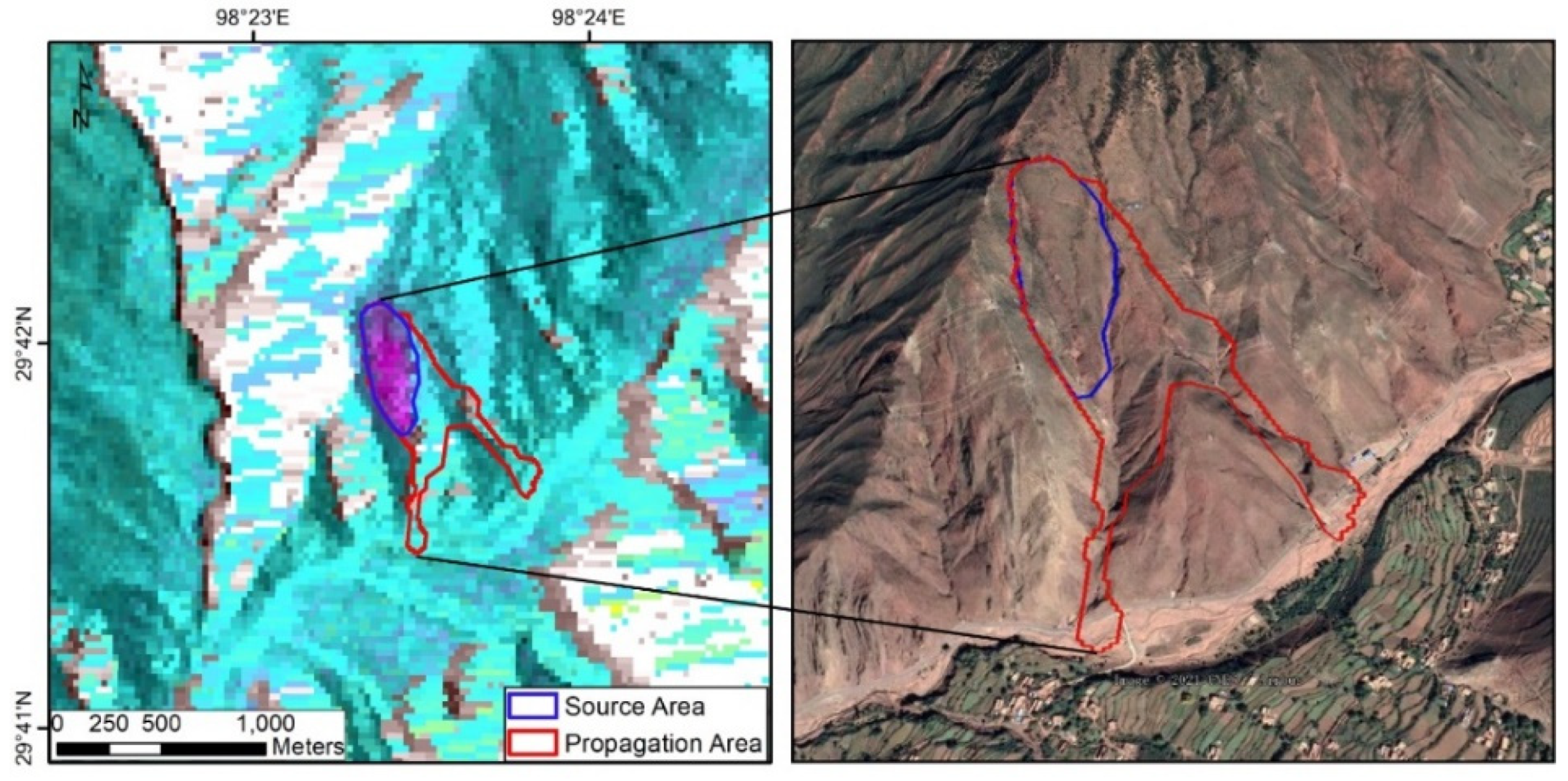
- Although there are partial gaps in certain areas, the D-InSAR stacking method can effectively identify unstable zones in the case study 2 area. Thirty-nine deformation zones were successfully detected. Compared with our results and expert interpretation results, we found that the combined method is simple and effective for regional landslide hazardous area identification.
- We discussed the influence of DEM resolution and diffusion angle on the results and their relationship with the number of MC simulations required. Among the three kinds of DEMs tested, the simulation effect of 12.5 m resolution is the optimal choice, and a higher resolution DEM is needed if high-quality simulation results are needed. A larger landslide volume requires larger diffusion angles because of the increased opportunities for collisions between blocks. Under the same conditions, due to the influence of the size of the source area, a DEM with higher resolution does not necessarily need additional MC simulation iterations. The larger diffusion angle requires more MC simulation iterations.
Author Contributions
Funding
Institutional Review Board Statement
Informed Consent Statement
Data Availability Statement
Conflicts of Interest
References
- Cui, P.; Guo, C.X.; Zhou, J.W.; Hao, M.H.; Xu, F.G. The mechanisms behind shallow failures in slopes comprised of landslide deposits. Eng. Geol. 2014, 180, 34–44. [Google Scholar] [CrossRef]
- Cui, P.; Chen, X.Q.; Zhu, Y.Y.; Su, F.H.; Wei, F.Q.; Han, Y.S.; Liu, H.J.; Zhuang, J.Q. The Wenchuan Earthquake (May 12, 2008), Sichuan Province, China, and resulting geohazards. Nat. Hazard. 2011, 56, 19–36. [Google Scholar] [CrossRef]
- Yin, Y.P.; Wang, F.W.; Sun, P. Landslide hazards triggered by the 2008 Wenchuan earthquake, Sichuan, China. Landslides 2009, 6, 139–152. [Google Scholar] [CrossRef]
- Hu, X.; Burgmann, R.; Schulz, W.H.; Fielding, E.J. Four-dimensional surface motions of the Slumgullion landslide and quantification of hydrometeorological forcing. Nat. Commun. 2020, 11, 1–9. [Google Scholar] [CrossRef] [PubMed]
- Kirschbaum, D.; Adler, R.; Adler, D.; Peters-Lidard, C.; Huffman, G. Global Distribution of Extreme Precipitation and High-Impact Landslides in 2010 Relative to Previous Years. J. Hydrometeorol. 2012, 13, 1536–1551. [Google Scholar] [CrossRef] [Green Version]
- Zhou, J.W.; Cui, P.; Hao, M.H. Comprehensive analyses of the initiation and entrainment processes of the 2000 Yigong catastrophic landslide in Tibet, China. Landslides 2016, 13, 39–54. [Google Scholar] [CrossRef]
- Watkinson, I.M.; Hall, R. Impact of communal irrigation on the 2018 Palu earthquake-triggered landslides. Nat. Geosci. 2019, 12, 940–945. [Google Scholar] [CrossRef]
- Li, W.; Chen, Y.; Liu, F.; Yang, H.F.; Liu, J.L.; Fu, B.H. Chain-Style Landslide Hazardous Process: Constraints From Seismic Signals Analysis of the 2017 Xinmo Landslide, SW China. J. Geophys. Res.: Solid Earth 2019, 124, 2025–2037. [Google Scholar] [CrossRef]
- Pudasaini, S.P.; Miller, S.A. The hypermobility of huge landslides and avalanches. Eng. Geol. 2013, 157, 124–132. [Google Scholar] [CrossRef]
- Petley, D. Global patterns of loss of life from landslides. Geology 2012, 40, 927–930. [Google Scholar] [CrossRef]
- Haque, U.; Blum, P.; da Silva, P.F.; Andersen, P.; Pilz, J.; Chalov, S.R.; Malet, J.P.; Auflic, M.J.; Andres, N.; Poyiadji, E.; et al. Fatal landslides in Europe. Landslides 2016, 13, 1545–1554. [Google Scholar] [CrossRef]
- Huang, R.Q. Some catastrophic landslides since the twentieth century in the southwest of China. Landslides 2009, 6, 69–81. [Google Scholar] [CrossRef]
- Haque, U.; da Silva, P.F.; Devoli, G.; Pilz, J.; Zhao, B.X.; Khaloua, A.; Wilopo, W.; Andersen, P.; Lu, P.; Lee, J.; et al. The human cost of global warming: Deadly landslides and their triggers (1995–2014). Sci. Total Environ. 2019, 682, 673–684. [Google Scholar] [CrossRef] [PubMed]
- Guzzetti, F.; Mondini, A.C.; Cardinali, M.; Fiorucci, F.; Santangelo, M.; Chang, K.T. Landslide inventory maps: New tools for an old problem. Earth Sci. Rev. 2012, 112, 42–66. [Google Scholar] [CrossRef] [Green Version]
- Dini, B.; Manconi, A.; Loew, S. Investigation of slope instabilities in NW Bhutan as derived from systematic DInSAR analyses. Eng. Geol. 2019, 259, 105111. [Google Scholar] [CrossRef]
- Moragues, S.; Lenzano, M.G.; Moreiras, S.; Lo Vecchio, A.; Lannutti, E.; Lenzano, L. Slope instability analysis in South Patagonia applying multivariate and bivariate techniques on Landsat images during 2001–2015 period. Catena 2019, 174, 339–352. [Google Scholar] [CrossRef]
- Yang, W.T.; Wang, Y.J.; Wang, Y.Q.; Ma, C.; Ma, Y.H. Retrospective deformation of the Baige landslide using optical remote sensing images. Landslides 2020, 17, 659–668. [Google Scholar] [CrossRef]
- Soeters, R.; Van Westen, C.J. Slope instability recognition, analysis and zonation. Landslides Investig. Mitig. 1996, 247, 129–177. [Google Scholar]
- Coe, J.A.; Bessette-Kirton, E.K.; Geertsema, M. Increasing rock-avalanche size and mobility in Glacier Bay National Park and Preserve, Alaska detected from 1984 to 2016 Landsat imagery. Landslides 2018, 15, 393–407. [Google Scholar] [CrossRef] [Green Version]
- Lauknes, T.R.; Shanker, A.P.; Dehls, J.F.; Zebker, H.A.; Henderson, I.H.C.; Larsen, Y. Detailed rockslide mapping in northern Norway with small baseline and persistent scatterer interferometric SAR time series methods. Remote Sens. Environ. 2010, 114, 2097–2109. [Google Scholar] [CrossRef]
- Xu, Q.; Zheng, G.; Li, W.; He, C.; Dong, X.; Guo, C.; Feng, W. Study on successive landslide damming events of jinsha river in baige village on Octorber 11 and November 3,2018. J. Eng. Geol. 2018, 26, 1534–1551. [Google Scholar]
- Barboux, C.; Delaloye, R.; Lambiel, C. Inventorying slope movements in an Alpine environment using DInSAR. Earth Surf. Processes Landf. 2014, 39, 2087–2099. [Google Scholar] [CrossRef] [Green Version]
- Bejar-Pizarro, M.; Notti, D.; Mateos, R.M.; Ezquerro, P.; Centolanza, G.; Herrera, G.; Bru, G.; Sanabria, M.; Solari, L.; Duro, J.; et al. Mapping Vulnerable Urban Areas Affected by Slow-Moving Landslides Using Sentinel-1 InSAR Data. Remote Sens. 2017, 9, 876. [Google Scholar] [CrossRef] [Green Version]
- Zienkiewicz, O.C.; Taylor, R.L.; Taylor, R.L.; Taylor, R.L. The Finite Element Method: Solid Mechanics; Butterworth-Heinemann: Oxford, UK, 2000; Volume 2. [Google Scholar]
- Lo, C.-M.; Lee, C.-F.; Chou, H.-T.; Lin, M.-L. Landslide at Su-Hua highway 115.9 k triggered by typhoon Megi in Taiwan. Landslides 2014, 11, 293–304. [Google Scholar] [CrossRef]
- Wang, F.; Sassa, K. Landslide simulation by a geotechnical model combined with a model for apparent friction change. Phys. Chemistry Earth Parts A/B/C 2010, 35, 149–161. [Google Scholar] [CrossRef]
- Ma, P.F.; Cui, Y.F.; Wang, W.X.; Lin, H.; Zhang, Y.Z. Coupling InSAR and numerical modeling for characterizing landslide movements under complex loads in urbanized hillslopes. Landslides 2021, 18, 1611–1623. [Google Scholar] [CrossRef]
- Wu, Y.M.; Lan, H.X. Debris Flow Analyst (DA): A debris flow model considering kinematic uncertainties and using a GIS platform. Eng. Geol. 2020, 279, 105877. [Google Scholar] [CrossRef]
- Ouyang, C.J.; He, S.M.; Xu, Q.; Luo, Y.; Zhang, W.C. A MacCormack-TVD finite difference method to simulate the mass flow in mountainous terrain with variable computational domain. Comput. Geosci. 2013, 52, 1–10. [Google Scholar] [CrossRef]
- Mergili, M.; Fischer, J.T.; Krenn, J.; Pudasaini, S.P. r.avaflow v1, an advanced open-source computational framework for the propagation and interaction of two-phase mass flows. Geosci. Model Dev. 2017, 10, 553–569. [Google Scholar] [CrossRef] [Green Version]
- Ouyang, C.J.; Zhou, K.Q.; Xu, Q.; Yin, J.H.; Peng, D.L.; Wang, D.P.; Li, W.L. Dynamic analysis and numerical modeling of the 2015 catastrophic landslide of the construction waste landfill at Guangming, Shenzhen, China. Landslides 2017, 14, 705–718. [Google Scholar] [CrossRef]
- Carrara, A.; Crosta, G.; Frattini, P. Comparing models of debris-flow susceptibility in the alpine environment. Geomorphology 2008, 94, 353–378. [Google Scholar] [CrossRef]
- Iverson, R.M.; Schilling, S.P.; Vallance, J.W. Objective delineation of lahar-inundation hazard zones. Geol. Soc. Am. Bull. 1998, 110, 972–984. [Google Scholar] [CrossRef]
- Hungr, O. A model for the runout analysis of rapid flow slides, debris flows, and avalanches. Can. Geotech. J. 1995, 32, 610–623. [Google Scholar] [CrossRef]
- Scheidegger, A.E. On the prediction of the reach and velocity of catastrophic landslides. Rock Mech. 1973, 5, 231–236. [Google Scholar] [CrossRef]
- Hunter, G.; Fell, R. Travel distance angle for "rapid" landslides in constructed and natural soil slopes. Can. Geotech. J. 2003, 40, 1123–1141. [Google Scholar] [CrossRef]
- Horton, P.; Jaboyedoff, M.; Rudaz, B.; Zimmermann, M. Flow-R, a model for susceptibility mapping of debris flows and other gravitational hazards at a regional scale. Nat. Hazards Earth Syst. Sci. 2013, 13, 869–885. [Google Scholar] [CrossRef] [Green Version]
- Zou, Q.; Jiang, H.; Cui, P.; Zhou, B.; Jiang, Y.; Qin, M.Y.; Liu, Y.G.; Li, C. A new approach to assess landslide susceptibility based on slope failure mechanisms. Catena 2021, 204, 105388. [Google Scholar] [CrossRef]
- Nguyen, B.Q.V.; Kim, Y.T. Regional-scale landslide risk assessment on Mt. Umyeon using risk index estimation. Landslides 2021, 18, 2547–2564. [Google Scholar] [CrossRef]
- GDAL. Available online: https://pypi.org/project/GDAL/2.4.0/ (accessed on 15 December 2021).
- Bartos, M. Pysheds: Simple and Fast Watershed Delineation in Python. Available online: https://github.com/mdbartos/pysheds (accessed on 11 November 2021).
- Corominas, J. The angle of reach as a mobility index for small and large landslides. Can. Geotech. J. 1996, 33, 260–271. [Google Scholar] [CrossRef]
- Li, L.P.; Lan, H.X.; Strom, A. Automatic generation of landslide profile for complementing landslide inventory. Geomat. Nat Haz. Risk. 2020, 11, 1000–1030. [Google Scholar] [CrossRef]
- Kang, H.; Yun-Tae, K. Parameter Analysis of Flow-R Model for Physical Vulnerability Assessment of Debris Flow Disaster in Regional Scale. J. Korean Soc. Hazard Mitig. 2017, 17, 233–245. [Google Scholar] [CrossRef]
- Rickenmann, D.; Zimmermann, M. The 1987 Debris flows in switzerland-documentation and analysis. Geomorphology 1993, 8, 175–189. [Google Scholar] [CrossRef]
- Gnyawali, K.R.; Xing, A.G.; Zhuang, Y. Dynamic analysis of the multi-staged ice-rock debris avalanche in the Langtang valley triggered by the 2015 Gorkha earthquake, Nepal. Eng. Geol. 2020, 265, 105440. [Google Scholar] [CrossRef]
- Xu, Q.; Shang, Y.J.; van Asch, T.; Wang, S.T.; Zhang, Z.Y.; Dong, X.J. Observations from the large, rapid Yigong rock slide-debris avalanche, southeast Tibet. Can. Geotech. J. 2012, 49, 589–606. [Google Scholar] [CrossRef]
- Delaney, K.B.; Evans, S.G. The 2000 Yigong landslide (Tibetan Plateau), rockslide-dammed lake and outburst flood: Review, remote sensing analysis, and process modelling. Geomorphology 2015, 246, 377–393. [Google Scholar] [CrossRef]
- Zhou, G.G.D.; Roque, P.J.C.; Xie, Y.X.; Song, D.R.; Zou, Q.; Chen, H.Y. Numerical study on the evolution process of a geohazards chain resulting from the Yigong landslide. Landslides 2020, 17, 2563–2576. [Google Scholar] [CrossRef]
- Massflow. Available online: http://www.massflow-software.com/ (accessed on 5 November 2021).
- Shen, Y.; Shen, W.; Li, T.; Guo, J.; Lei, Y. Numerical investigation on impact of bed entrainment to the mobility of rapid flow-like landslides. J. Eng. Geol. 2019, 27, 1405–1414. [Google Scholar]
- Huang, R.Q.; Xu, Q. Catastrophic landslides in China; Science Press: Beijing, China, 2008. [Google Scholar]
- Shang, Y.J.; Yang, Z.F.; Li, L.H.; Liu, D.; Liao, Q.L.; Wang, Y.C. A super-large landslide in Tibet in 2000: Background, occurrence, disaster, and origin. Geomorphology 2003, 54, 225–243. [Google Scholar] [CrossRef]
- Quinn, P.; Beven, K.; Chevallier, P.; Planchon, O. The prediction of hillslope flow paths for distributed hydrological modeling using digital terrain models. Hydrol. Processes 1991, 5, 59–79. [Google Scholar] [CrossRef]
- Perla, R.; Cheng, T.; McClung, D.M. A two–parameter model of snow–avalanche motion. J. Glaciol. 1980, 26, 197–207. [Google Scholar] [CrossRef] [Green Version]
- Flow-R. Available online: https://www.terranum.ch/en/products/flow-r/ (accessed on 19 July 2021).
- Wu, Y.M.; Lan, H.X. Landslide Analysta landslide propagation model considering block size heterogeneity. Landslides 2019, 16, 1107–1120. [Google Scholar] [CrossRef]
- Pastor, M.; Blanc, T.; Haddad, B.; Petrone, S.; Morles, M.S.; Drempetic, V.; Issler, D.; Crosta, G.B.; Cascini, L.; Sorbino, G.; et al. Application of a SPH depth-integrated model to landslide run-out analysis. Landslides 2014, 11, 793–812. [Google Scholar] [CrossRef] [Green Version]
- Yao, X.; Deng, J.; Liu, X.; Zhou, Z.; Yao, J.; Dai, F.; Ren, K.; Li, L. Primary Recognition of Active Landslides and Development Rule Analysis for Pan Three-river-parallel Territory of Tibet Plateau. Adv. Eng. Sci. 2020, 52, 16–37. [Google Scholar]
- Fan, X.M.; Xu, Q.; Alonso-Rodriguez, A.; Subramanian, S.S.; Li, W.L.; Zheng, G.; Dong, X.J.; Huang, R.Q. Successive landsliding and damming of the Jinsha River in eastern Tibet, China: Prime investigation, early warning, and emergency response. Landslides 2019, 16, 1003–1020. [Google Scholar] [CrossRef]
- Ding, C.; Feng, G.C.; Liao, M.S.; Tao, P.J.; Zhang, L.; Xu, Q. Displacement history and potential triggering factors of Baige landslides, China revealed by optical imagery time series. Remote Sens. Environ. 2021, 254. [Google Scholar] [CrossRef]
- Goldstein, R.M.; Werner, C.L. Radar interferogram filtering for geophysical applications. Geophys. Res. Lett. 1998, 25, 4035–4038. [Google Scholar] [CrossRef] [Green Version]
- Guo, C.; Yan, Y.; Zhang, Y.; Zhang, X.; Zheng, Y.; Li, X.; Yang, Z.; Wu, R. Study on the Creep-Sliding Mechanism of the Giant Xiongba Ancient Landslide Based on the SBAS-InSAR Method, Tibetan Plateau, China. Remote Sens. 2021, 13, 3365. [Google Scholar] [CrossRef]
- Li, L.J.; Yao, X.; Yao, J.M.; Zhou, Z.K.; Feng, X.; Liu, X.H. Analysis of deformation characteristics for a reservoir landslide before and after impoundment by multiple D-InSAR observations at Jinshajiang River, China. Nat. Hazard. 2019, 98, 719–733. [Google Scholar] [CrossRef]
- Schlogel, R.; Doubre, C.; Malet, J.P.; Masson, F. Landslide deformation monitoring with ALOS/PALSAR imagery: A D-InSAR geomorphological interpretation method. Geomorphology 2015, 231, 314–330. [Google Scholar] [CrossRef]
- Lan, H.X.; Martin, C.D.; Lim, C.H. RockFall analyst: A GIS extension for three-dimensional and spatially distributed rockfall hazard modeling. Comput. Geosci. 2007, 33, 262–279. [Google Scholar] [CrossRef]
- Eidsvig, U.M.K.; Papathoma-Kohle, M.; Du, J.; Glade, T.; Vangelsten, B.V. Quantification of model uncertainty in debris flow vulnerability assessment. Eng. Geol. 2014, 181, 15–26. [Google Scholar] [CrossRef]
- Zhang, W.H.; Montgomery, D.R. DIgital elevation model grid size, landscape representation, and hydrologic simulations. Water Resour. Res. 1994, 30, 1019–1028. [Google Scholar] [CrossRef]
- Quinn, P.; Beven, K.; Lamb, R. The in (a/tan/β) index: How to calculate it and how to use it within the topmodel framework. Hydrol. Processes 1995, 9, 161–182. [Google Scholar] [CrossRef]
- Okura, Y.; Kitahara, H.; Sammori, T.; Kawanami, A. The effects of rockfall volume on runout distance. Eng. Geol. 2000, 58, 109–124. [Google Scholar] [CrossRef]
- Hovius, N.; Stark, C.P.; Allen, P.A. Sediment flux from a mountain belt derived by landslide mapping. Geology 1997, 25, 231–234. [Google Scholar] [CrossRef] [Green Version]
- Milledge, D.G.; Bellugi, D.; McKean, J.A.; Densmore, A.L.; Dietrich, W.E. A multidimensional stability model for predicting shallow landslide size and shape across landscapes. J. Geophys. Res.-Earth Surf. 2014, 119, 2481–2504. [Google Scholar] [CrossRef] [Green Version]
- Taylor, F.E.; Malamud, B.D.; Witt, A.; Guzzetti, F. Landslide shape, ellipticity and length-to-width ratios. Earth Surf. Processes Landforms 2018, 43, 3164–3189. [Google Scholar] [CrossRef]
- Jaboyedoff, M.; Rudaz, B.; Horton, P. Concepts and parameterisation of Perla and FLM model using Flow-R for debris flow. In Proceedings of the 5th Canadian Conference on Geotechnique and Natural Hazards, Kelowna, BC, Canada, 15–17 May 2011. [Google Scholar]
- IUGS–International Working Group. A suggested method for describing the rate of movement of a landslide. Bull. Int. Assoc. Eng. Geol. 1995, 52, 75–78. [Google Scholar] [CrossRef]
- Hungr, O.; Corominas, J.; Eberhardt, E. Estimating landslide motion mechanism, travel distance and velocity. In Landslide Risk Management; CRC Press: Boca Raton, FL, USA, 2005; pp. 109–138. [Google Scholar]
- Wen, B.P.; Wang, S.J.; Wang, E.Z.; Zhang, J.M. Characteristics of rapid giant landslides in China. Landslides 2004, 1, 247–261. [Google Scholar] [CrossRef]







| Area_ID | LA_ID | IoU | Precision | Recall |
|---|---|---|---|---|
| i | 1 | 0.545 | 0.555 | 0.969 |
| 2 | 0.585 | 0.773 | 0.706 | |
| 3 | 0.683 | 0.853 | 0.774 | |
| ii | 4 | 0.775 | 0.878 | 0.868 |
| 5 | 0.797 | 0.928 | 0.849 | |
| 6 | 0.717 | 0.767 | 0.917 | |
| 7 | 0.898 | 0.973 | 0.921 | |
| 8 | 0.614 | 0.701 | 0.833 | |
| 9 | 0.731 | 0.906 | 0.791 | |
| iii | 10 | 0.760 | 0.835 | 0.894 |
| 11 | 0.746 | 0.859 | 0.851 | |
| 12 | 0.616 | 0.730 | 0.798 |
| DEM | Resolution | Acquisition Time |
|---|---|---|
| ALOS | 12.5 m | June 2008 |
| ASTER GDEM | 30 m | 2000–2009 |
| SRTM | 90 m | 2000 |
| Parameter Name | Setting Range |
|---|---|
| Diffusion Angle | 15°–90° |
| Friction Angle | 10°–30° |
| Maximum Speed | 11–70 m/s |
Publisher’s Note: MDPI stays neutral with regard to jurisdictional claims in published maps and institutional affiliations. |
© 2022 by the authors. Licensee MDPI, Basel, Switzerland. This article is an open access article distributed under the terms and conditions of the Creative Commons Attribution (CC BY) license (https://creativecommons.org/licenses/by/4.0/).
Share and Cite
Liu, J.; Wu, Y.; Gao, X.; Zhang, X. A Simple Method of Mapping Landslides Runout Zones Considering Kinematic Uncertainties. Remote Sens. 2022, 14, 668. https://doi.org/10.3390/rs14030668
Liu J, Wu Y, Gao X, Zhang X. A Simple Method of Mapping Landslides Runout Zones Considering Kinematic Uncertainties. Remote Sensing. 2022; 14(3):668. https://doi.org/10.3390/rs14030668
Chicago/Turabian StyleLiu, Jia, Yuming Wu, Xing Gao, and Xuehua Zhang. 2022. "A Simple Method of Mapping Landslides Runout Zones Considering Kinematic Uncertainties" Remote Sensing 14, no. 3: 668. https://doi.org/10.3390/rs14030668
APA StyleLiu, J., Wu, Y., Gao, X., & Zhang, X. (2022). A Simple Method of Mapping Landslides Runout Zones Considering Kinematic Uncertainties. Remote Sensing, 14(3), 668. https://doi.org/10.3390/rs14030668


