Identification of Streamside Landslides with the Use of Unmanned Aerial Vehicles (UAVs) in Greece, Romania, and Turkey
Abstract
:1. Introduction
2. Materials and Methods
2.1. Case Studies
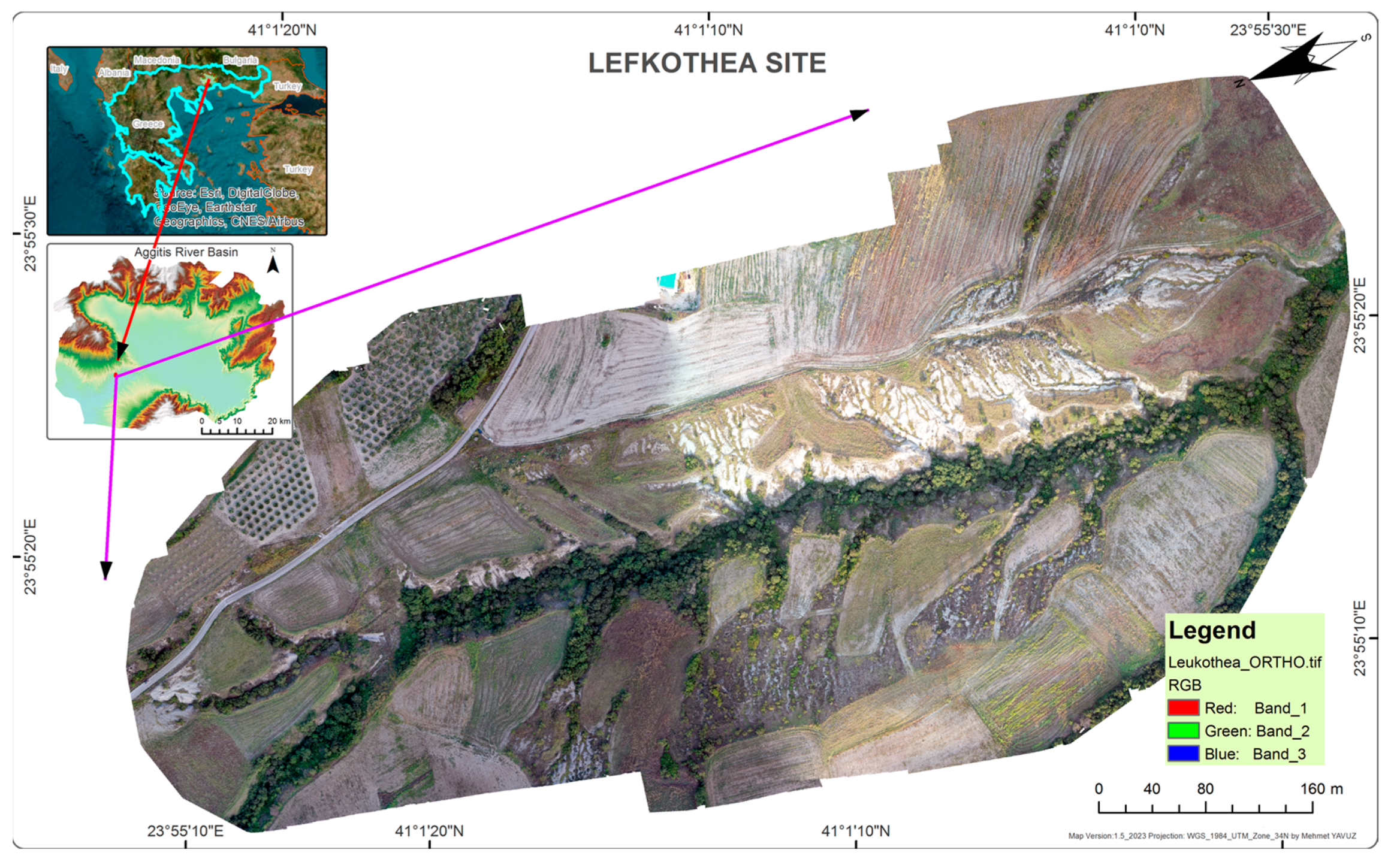
2.1.1. The Lefkothea Site of the Aggitis River Watershed (GREECE)
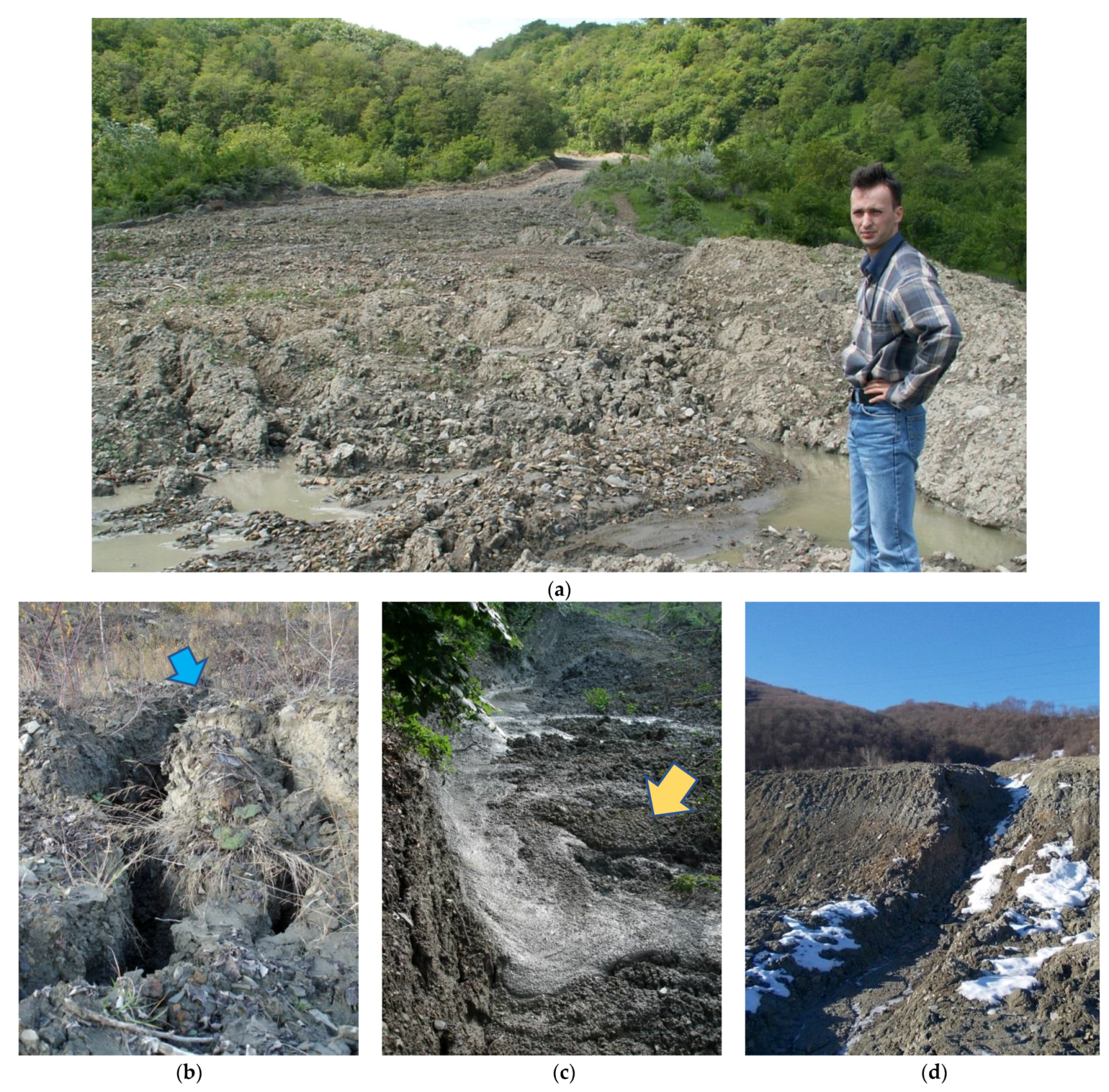
2.1.2. The Chirlesti Mudflow of the Buzau River Watershed (ROMANIA)
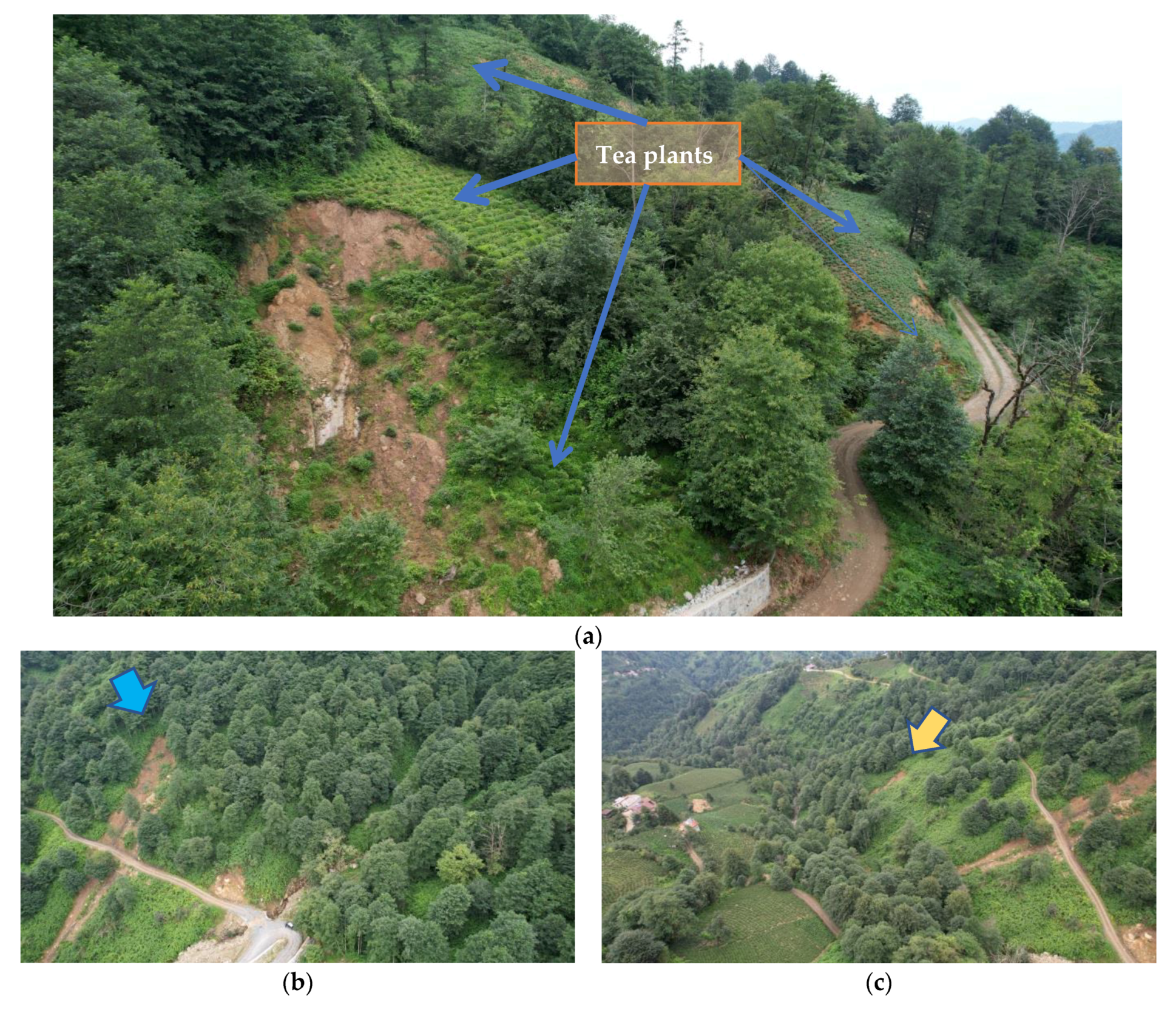
2.1.3. The Sirtoba Landslide Site of the Arhavi River Watershed (TURKEY)
2.2. Hardware, Software, and Methodology
2.2.1. UAV Flight Planning and Acquisition of UAV Imagery
2.2.2. Topographic Correction of Aerial Products
2.2.3. Photogrammetric Workflow
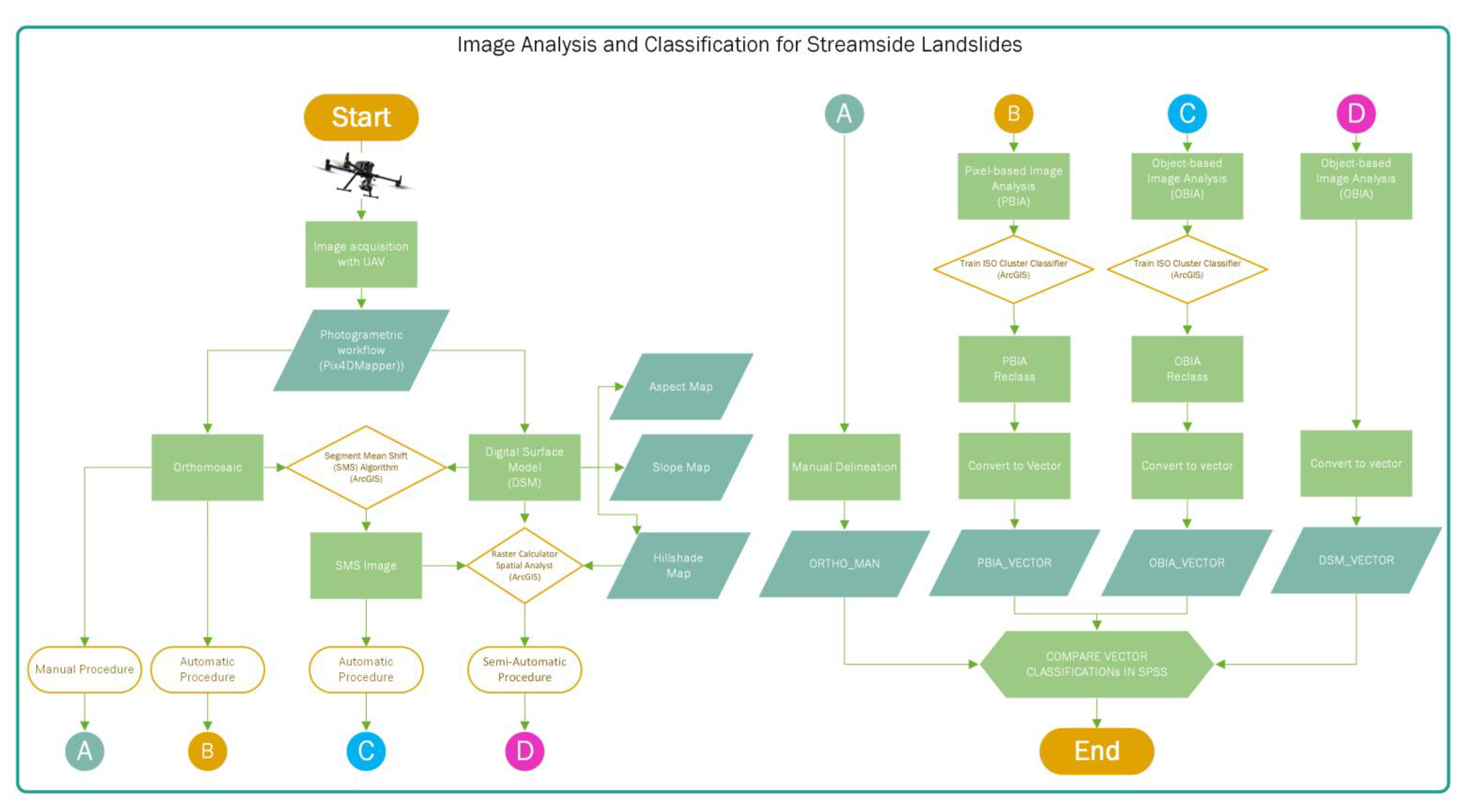
2.2.4. Image Analysis and Classification
3. Results
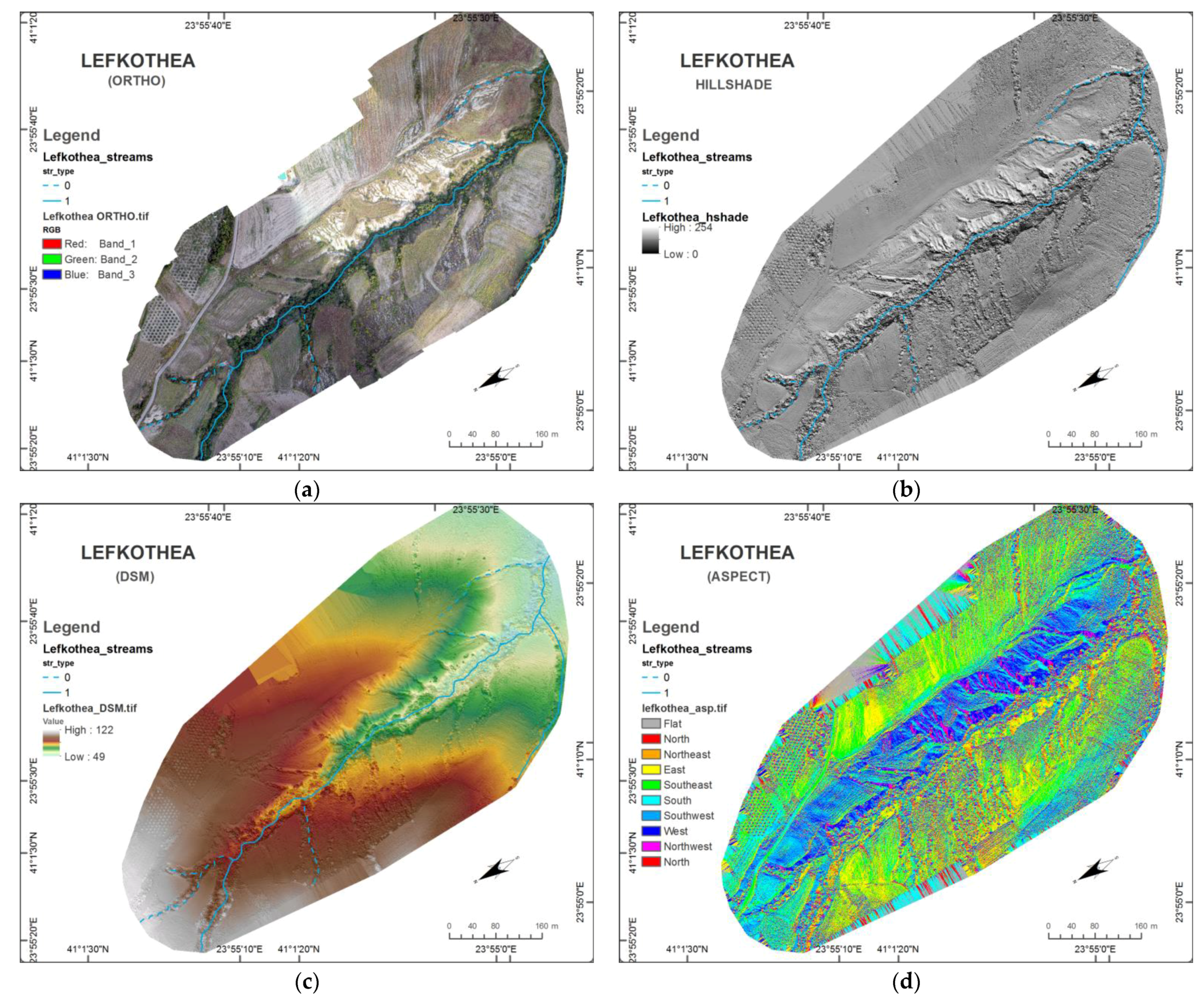
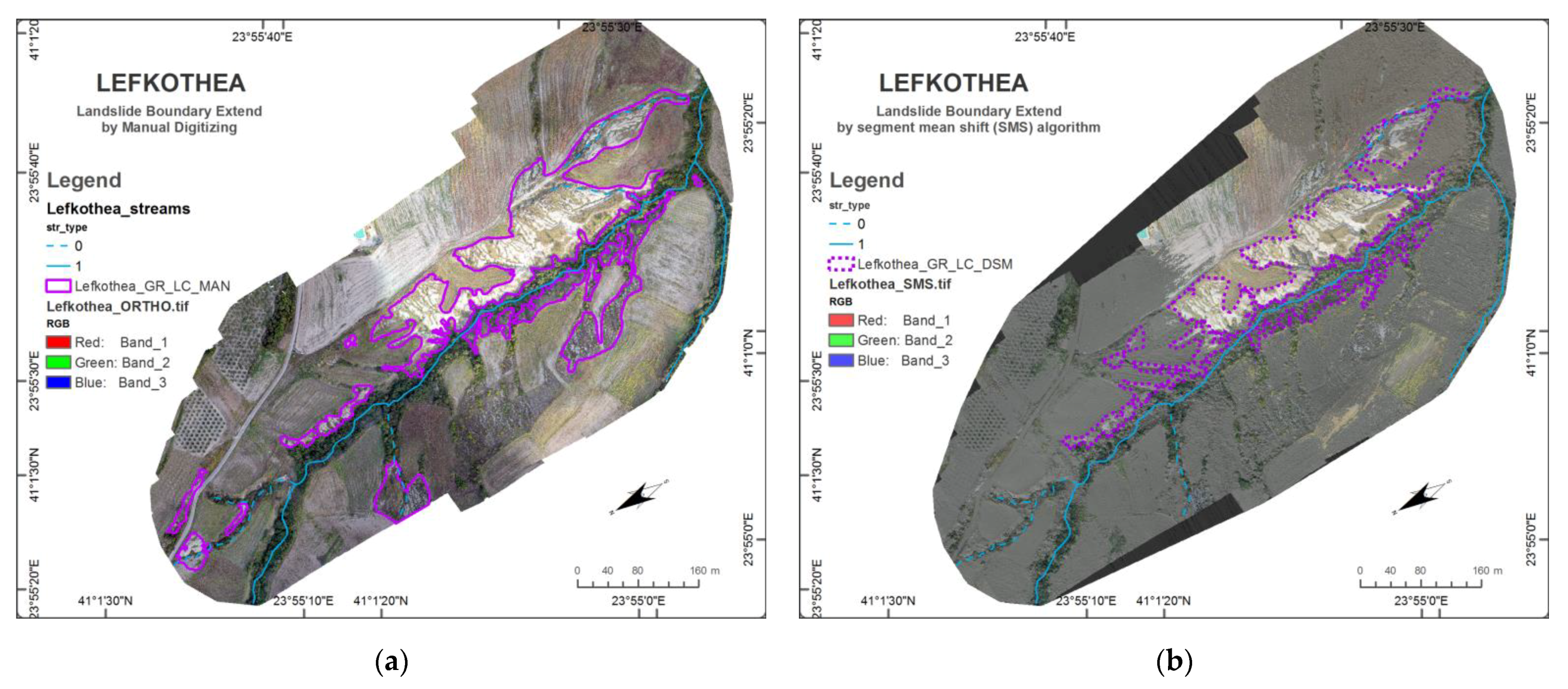
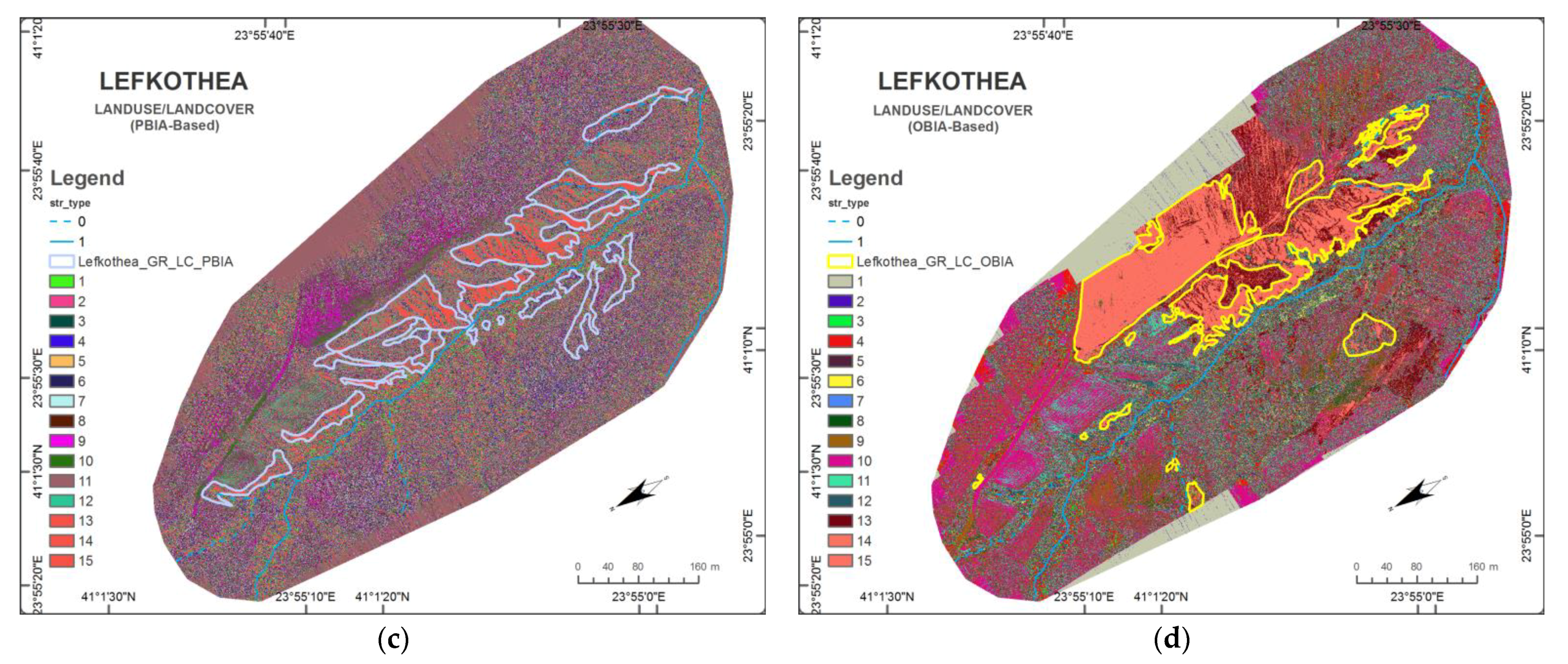
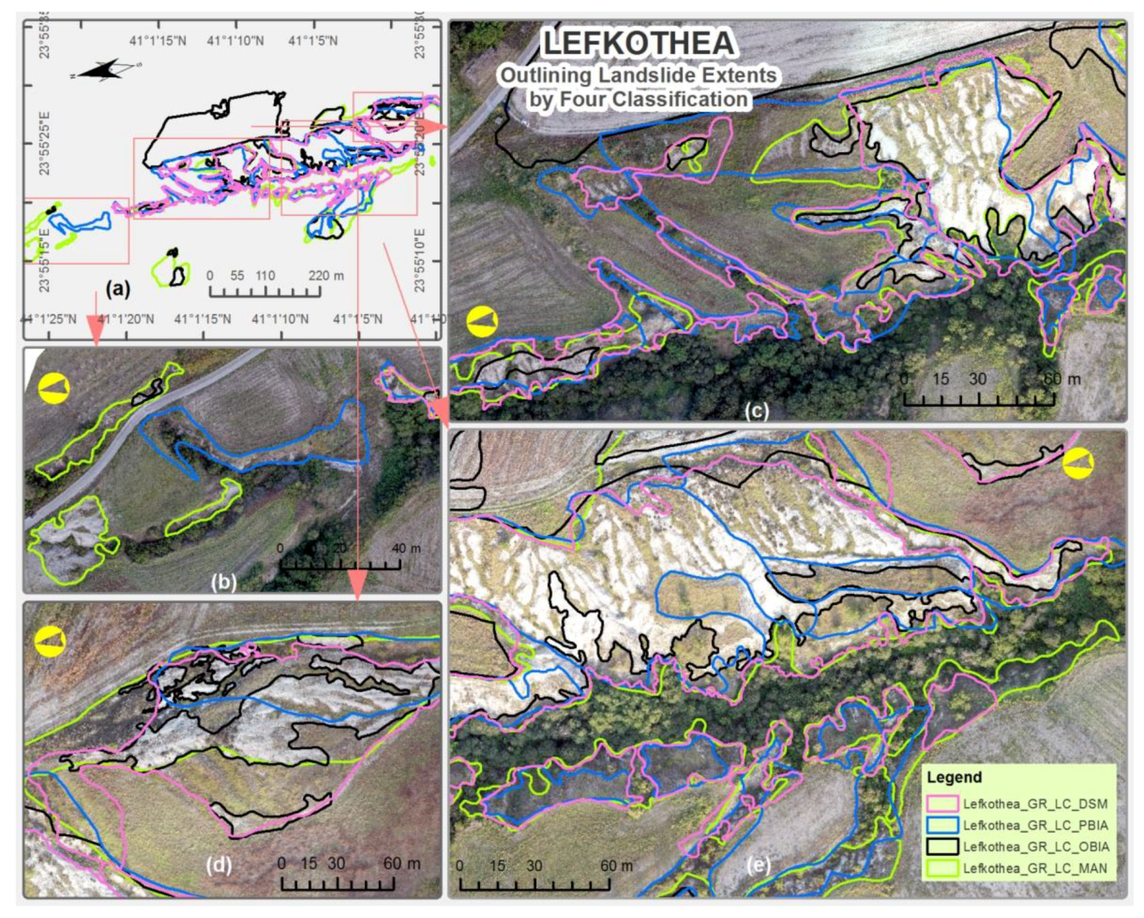
3.1. The Results of the Lefkothea Site
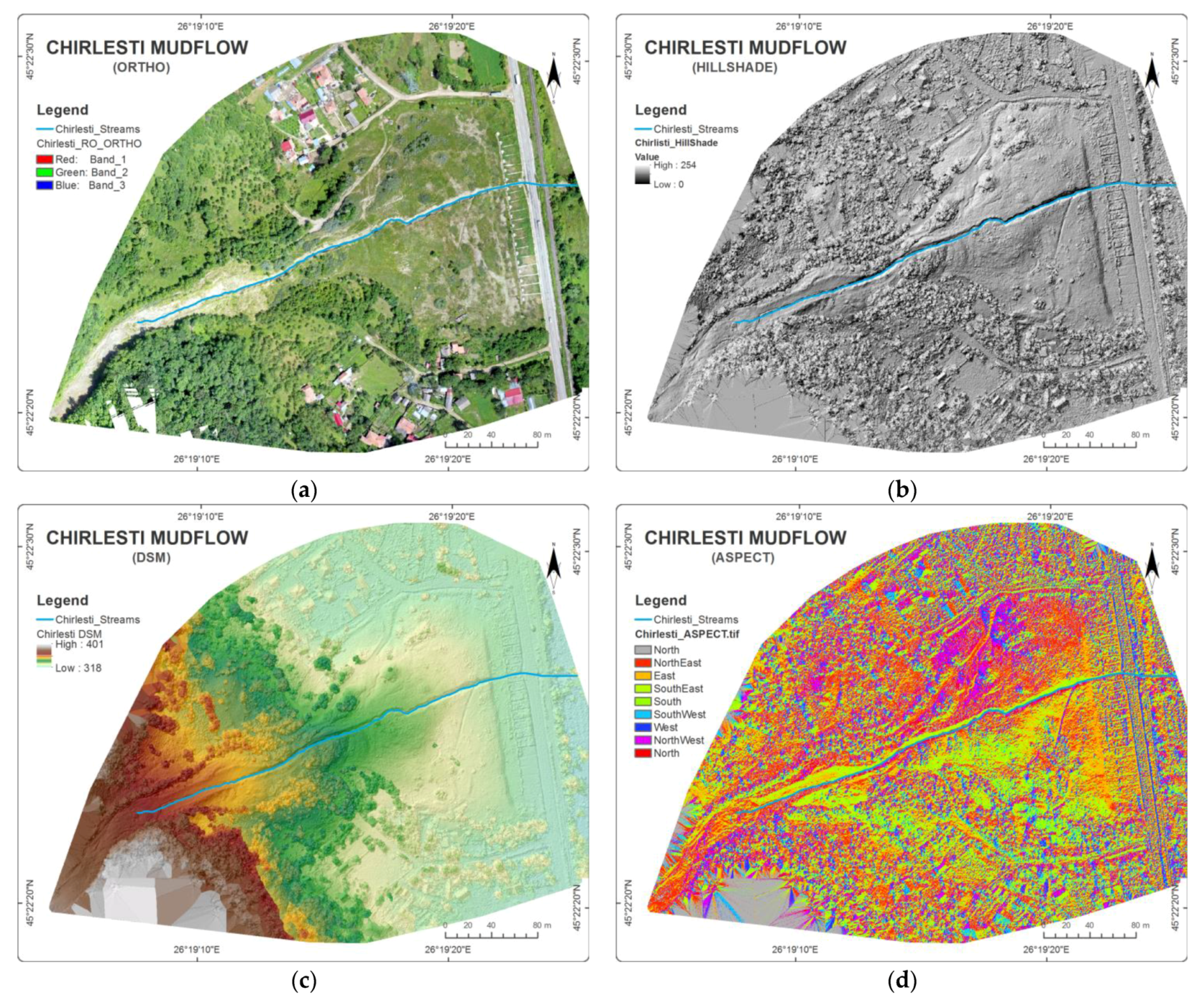
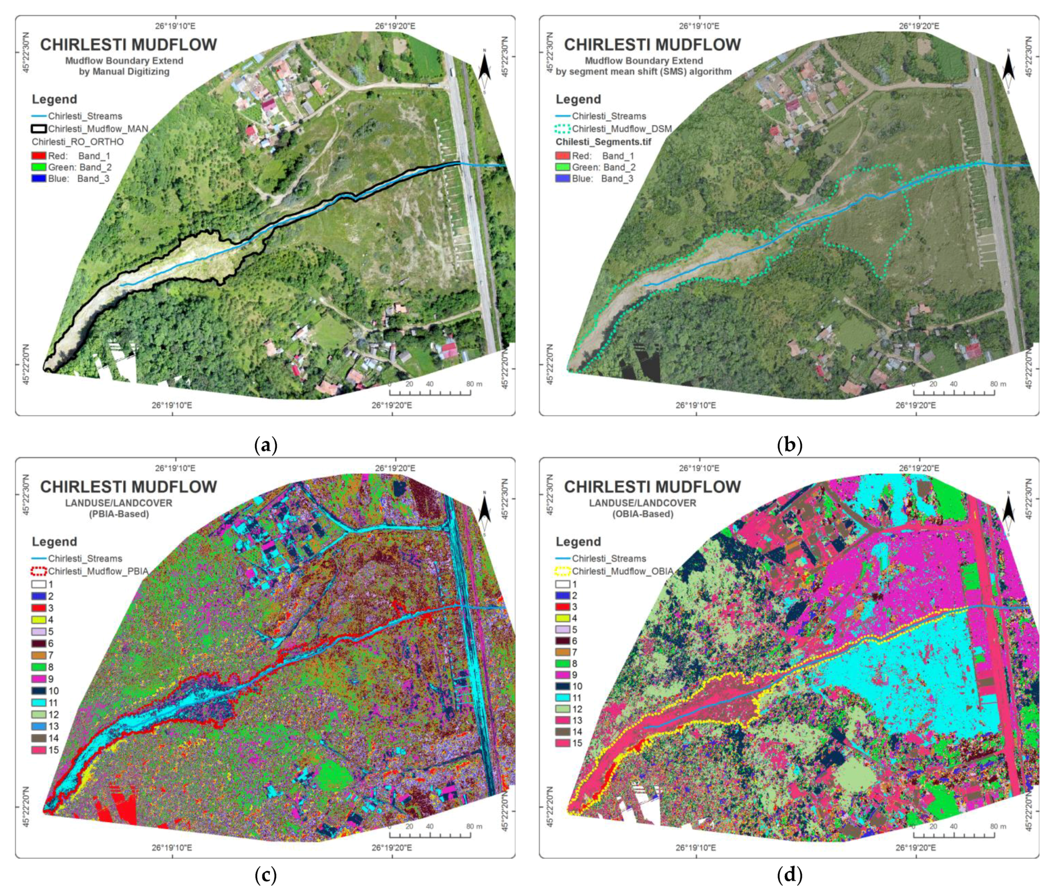
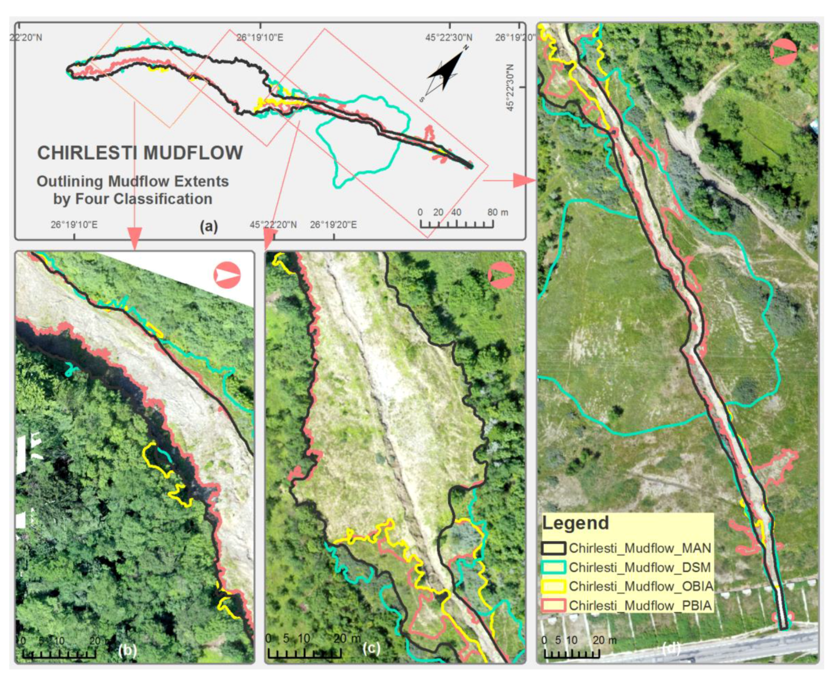
3.2. The Results of the Chirlesti Site
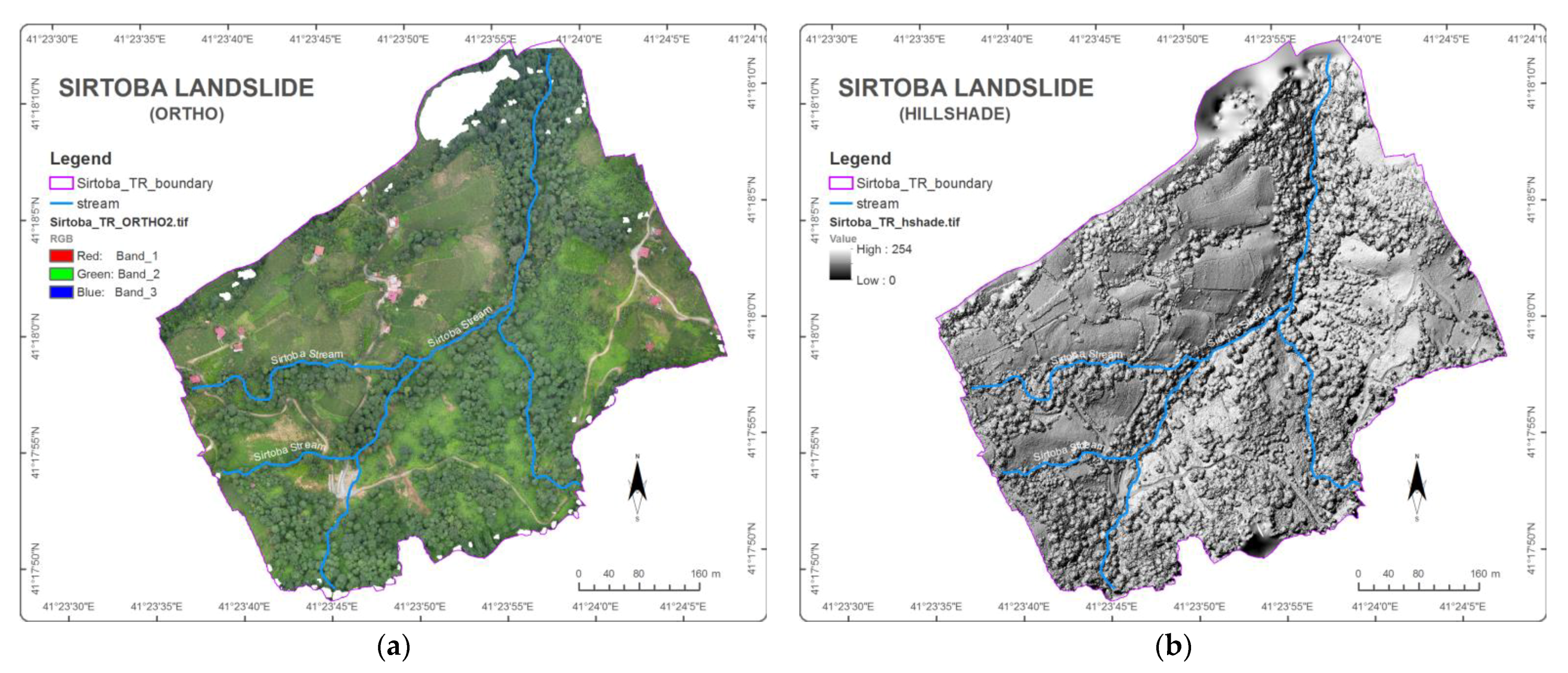
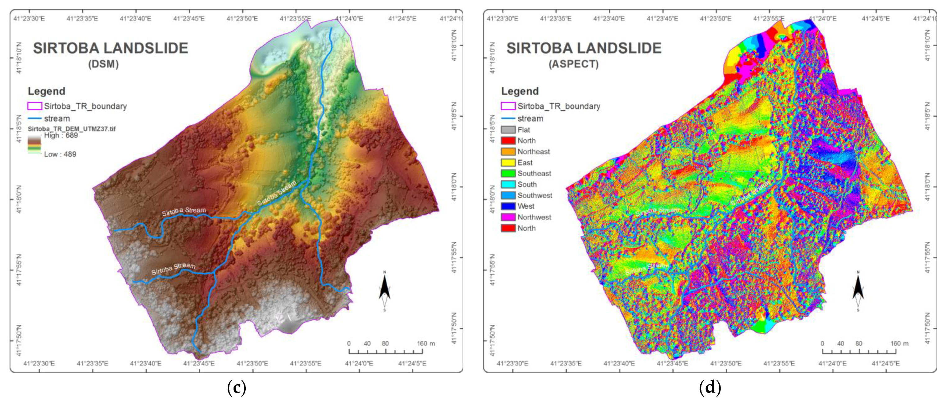
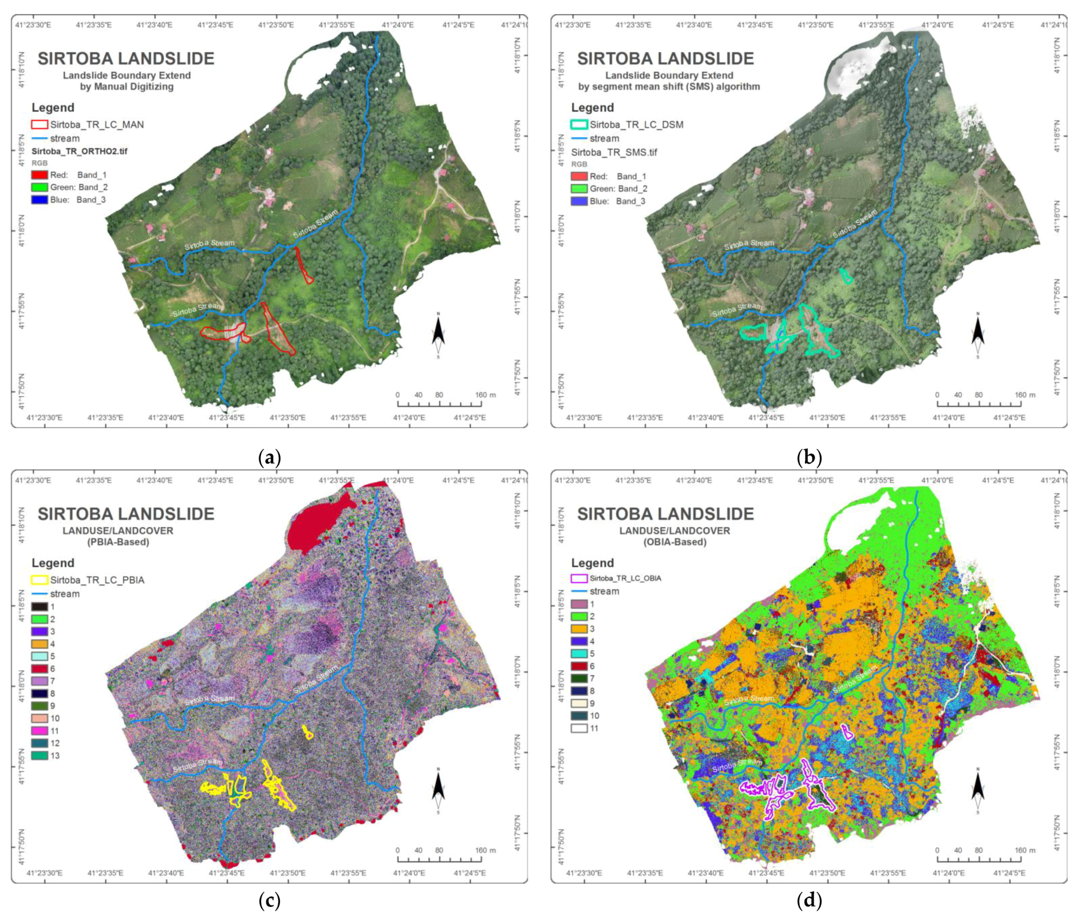
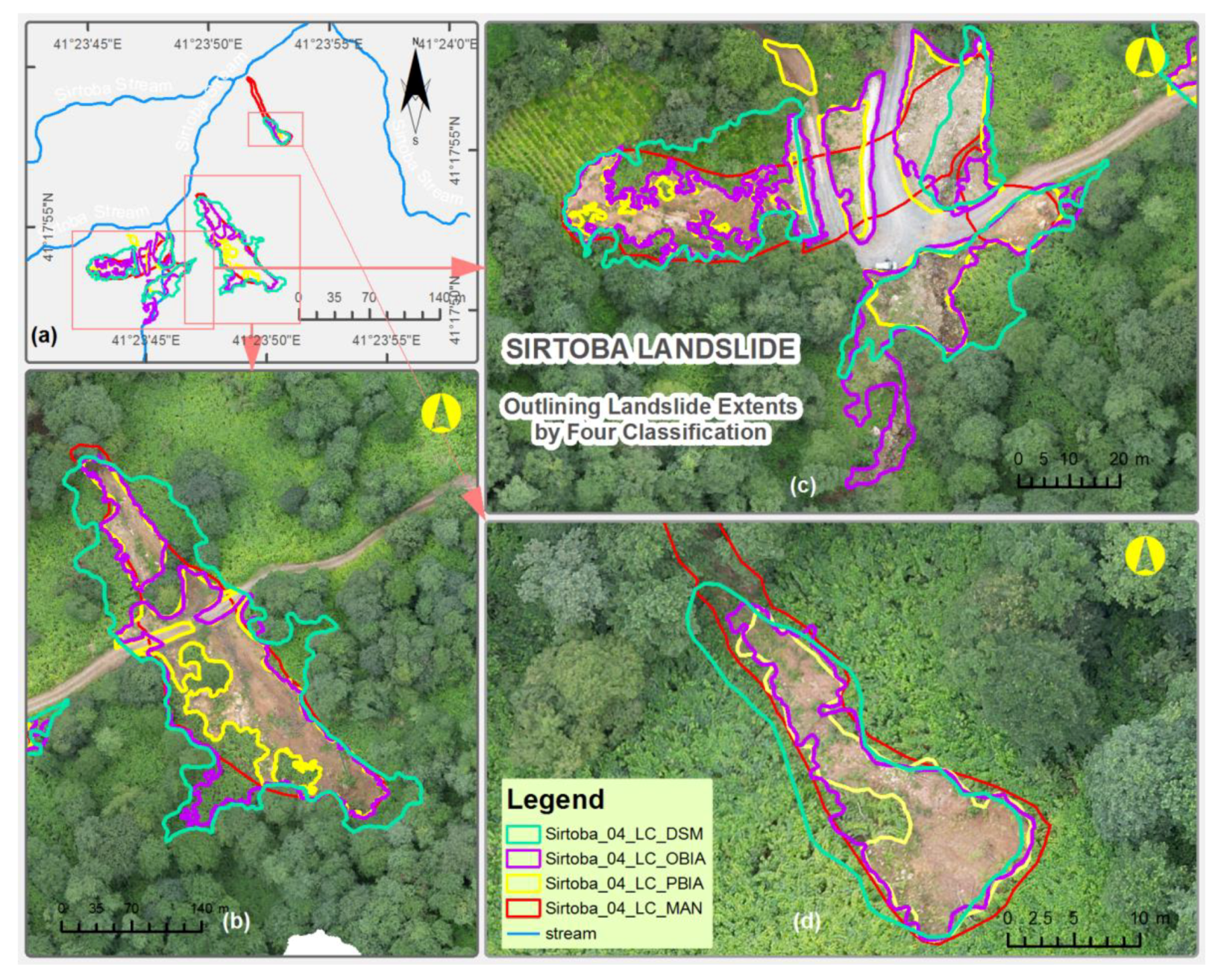
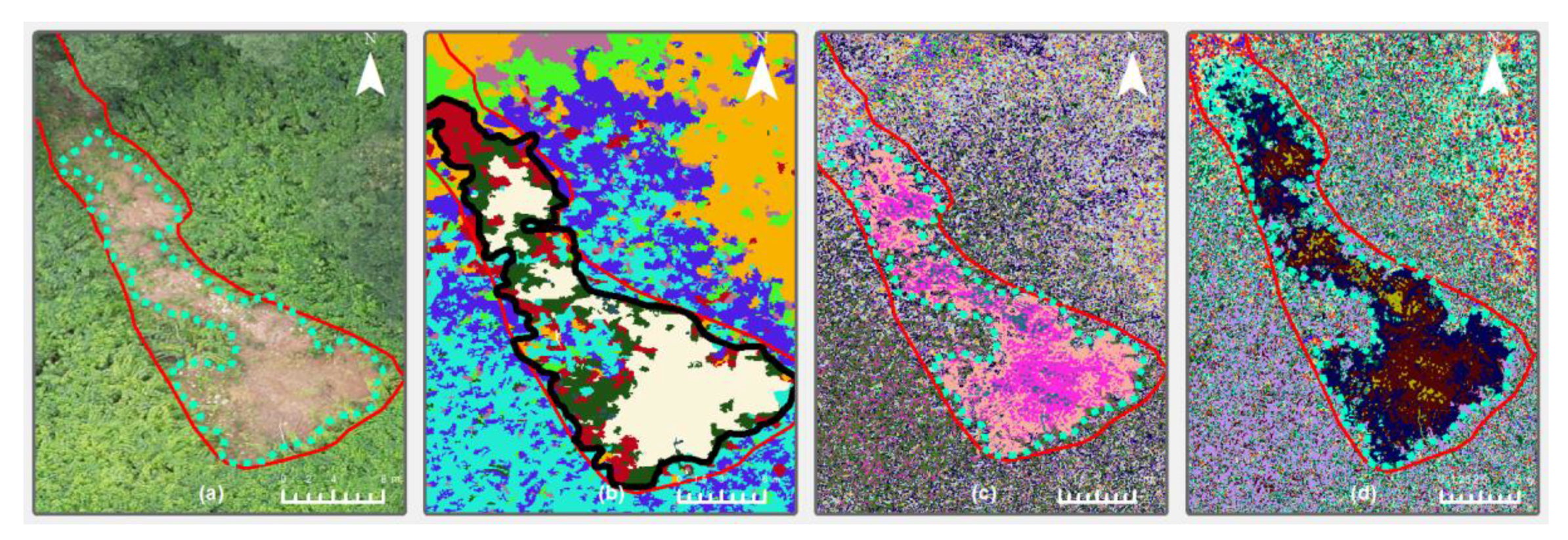
3.3. The Results of the Sirtoba Site
4. Discussion
5. Conclusions
Author Contributions
Funding
Data Availability Statement
Conflicts of Interest
Abbreviations
| CORS | Continuously Operating Reference Stations |
| CMOS | Complementary Metal–Oxide–Semiconductor |
| DSM | Digital Surface Model |
| GCPs | Ground Control Points |
| GIS | Geographic Information Systems |
| GNSS | Global Navigation Satellite System |
| GPS | Global Positioning System |
| DGPS | Differential GPS |
| GPS-GNSS | Global Positioning System/Global Navigation Satellite System |
| GSD | Ground Sampling Distance |
| IMU | Interactive Multimedia Unit |
| InSAR | Interferometric Synthetic Aperture Radar |
| ISO | Iterative Self-Organizing |
| LiDAR | Light Detection and Measurement |
| Lisa | Laser Interferometer Space Antenna |
| ML | Machine Learning |
| MP | Megapixel |
| NDSI | Normalized Difference Soil Index |
| NDVI | Normalized Difference Vegetation Index |
| NDWI | Normalized Difference Water Index |
| NE | Northeast |
| OBIA | Object-Based Image Analysis |
| OTDR | Optical Time Domain Reflectometer |
| PBIA | Pixel-Based Image Analysis |
| PPK | Postprocessing Kinematic |
| RGB | Red, Green, Blue |
| RTK | Real-Time Kinematic |
| SAR | Synthetic Aperture Radar |
| SfM | Structure from Motion |
| SMS | Segment Mean Shift |
| SVM | Support Vector Machine |
| SW | Southwest |
| UAV | Unmanned Aerial Vehicle |
| WAAS | Wide Area Augmentation System |
| WGS84 | World Geodetic System 1984 |
| WSN | Wireless Sensor Networks |
References
- Mokarram, M.; Sathyamoorthy, D. A review of landform classification methods. Spat. Inf. Res. 2018, 26, 647–660. [Google Scholar] [CrossRef]
- Intrieri, E.; Gigli, G.; Casagli, N.; Nadim, F. Brief communication” Landslide Early Warning System: Toolbox and general concepts”. Nat. Hazards Earth Syst. Sci. 2013, 13, 85–90. [Google Scholar] [CrossRef]
- Hungr, O.; Leroueil, S.; Picarelli, L. The Varnes classification of landslide types, an update. Landslides 2014, 11, 167–194. [Google Scholar] [CrossRef]
- Scaioni, M.; Longoni, L.; Melillo, V.; Papini, M. Remote sensing for landslide investigations: An overview of recent achievements and perspectives. Remote Sens. 2014, 6, 9600–9652. [Google Scholar] [CrossRef]
- Schuster, R.L.; Wieczorek, G.F. Landslide triggers and types. In Landslides; Routledge: London, UK, 2018; pp. 59–78. [Google Scholar]
- Šilhán, K. Dendrogeomorphology of different landslide types: A review. Forests 2021, 12, 261. [Google Scholar] [CrossRef]
- Varnes, D.; Eckel, E. Landslide types and processes. In Landslides and Engineering Practice by the Committee on Landslide Investigations; National Research Council (U.S.), Highway Research Board Special Report; Committee on Landslide Investigations: Washington DC, USA, 1958. [Google Scholar]
- Bracken, L.J.; Turnbull, L.; Wainwright, J.; Bogaart, P. Sediment connectivity: A framework for understanding sediment transfer at multiple scales. Earth Surf. Process. Landf. 2015, 40, 177–188. [Google Scholar] [CrossRef]
- Campforts, B.; Shobe, C.M.; Steer, P.; Vanmaercke, M.; Lague, D.; Braun, J. HyLands 1.0: A hybrid landscape evolution model to simulate the impact of landslides and landslide-derived sediment on landscape evolution. Geosci. Model Dev. 2020, 13, 3863–3886. [Google Scholar] [CrossRef]
- Huang, Y.; Xu, C.; Zhang, X.; Li, L. Bibliometric analysis of landslide research based on the WOS database. Nat. Hazards Res. 2022, 2, 49–61. [Google Scholar] [CrossRef]
- Jasim, M.M.; Al-Khaddar, R.M.; Al-Rumaithi, A. Prediction of bearing capacity, angle of internal friction, cohesion, and plasticity index using ANN (Case Study of Baghdad, Iraq). Int. J. Civ. Eng. Technol. 2019, 10, 2670–2679. [Google Scholar]
- Deb, S.K.; El-Kadi, A.I. Susceptibility assessment of shallow landslides on Oahu, Hawaii, under extreme-rainfall events. Geomorphology 2009, 108, 219–233. [Google Scholar] [CrossRef]
- Zhang, H.; Zhao, Z.; Ma, G.; Sun, L. Quantitative evaluation of soil anti-erodibility in riverbank slope remediated with nature-based soil bioengineering in Liaohe River, Northeast China. Ecol. Eng. 2020, 151, 105840. [Google Scholar] [CrossRef]
- Schmidt, K.; Roering, J.; Stock, J.; Dietrich, W.; Montgomery, D.; Schaub, T. The variability of root cohesion as an influence on shallow landslide susceptibility in the Oregon Coast Range. Can. Geotech. J. 2001, 38, 995–1024. [Google Scholar] [CrossRef]
- EPA. Total Maximum Daily Load for Sediment Redwood Creek, California; United States Environmental Protection Agency Region, Ed.; Generic: San Francisco, CA, USA, 1998; p. 73. [Google Scholar]
- Sutherland, D.G.; Ball, M.H.; Hilton, S.J.; Lisle, T.E. Evolution of a landslide-induced sediment wave in the Navarro River, California. Geol. Soc. Am. Bull. 2002, 114, 1036–1048. [Google Scholar] [CrossRef]
- Benda, L.; Dunne, T. Stochastic forcing of sediment supply to channel networks from landsliding and debris flow. Water Resour. Res. 1997, 33, 2849–2863. [Google Scholar] [CrossRef]
- Schuster, R.L.; Highland, L.M. Impact of landslides and innovative landslide-mitigation measures on the natural environment. In Proceedings of the International Conference on Slope Engineering, Hong Kong, China, 8–10 December 2003. [Google Scholar]
- Benda, L. The influence of debris flows on channels and valley floors in the Oregon Coast Range, USA. Earth Surf. Process. Landf. 1990, 15, 457–466. [Google Scholar] [CrossRef]
- Swanson, F. Natural disturbance effects on riparian areas. In Riparian Resources, Proceedings of the Symposium on the Disturbances, Management, Economics, and Conflicts Associated with Riparian Ecosystems, Logan, Utah, 18–19 April 1991; Utah State University: Logan, UT, USA, 1994; pp. 11–14. [Google Scholar]
- Baum, R.L.; Reid, M.E. Geology, hydrology, and mechanics of a slow-moving. In Clay Shale Slope Instability; The Geological Society of America: Boulder, CO, USA, 1995; Volume 10, p. 79. [Google Scholar]
- Bogaard, T.A.; Greco, R. Landslide hydrology: From hydrology to pore pressure. Wiley Interdiscip. Rev. Water 2016, 3, 439–459. [Google Scholar] [CrossRef]
- Dikau, R.; Cavallin, A.; Jäger, S. Databases and GIS for landslide research in Europe. Geomorphology 1996, 15, 227–239. [Google Scholar] [CrossRef]
- Pánek, T. Recent progress in landslide dating: A global overview. Prog. Phys. Geogr. 2015, 39, 168–198. [Google Scholar] [CrossRef]
- Glade, T.; Crozier, M.J. Landslide hazard and risk: Concluding comment and perspectives. In Landslide Hazard Risk; Wiley: Chichester, UK, 2005; pp. 767–774. [Google Scholar]
- Rogers, D.; Tsirkunov, V. Costs and benefits of early warning systems. In Global Assessment Report; ISDR: Geneva, Switzerland; The World Bank: Washington, DC, USA, 2011. [Google Scholar]
- Pecoraro, G.; Calvello, M.; Piciullo, L. Monitoring strategies for local landslide early warning systems. Landslides 2019, 16, 213–231. [Google Scholar] [CrossRef]
- Xu, Q.; Peng, D.; Zhang, S.; Zhu, X.; He, C.; Qi, X.; Zhao, K.; Xiu, D.; Ju, N. Successful implementations of a real-time and intelligent early warning system for loess landslides on the Heifangtai terrace, China. Eng. Geol. 2020, 278, 105817. [Google Scholar] [CrossRef]
- Guzzetti, F.; Mondini, A.C.; Cardinali, M.; Fiorucci, F.; Santangelo, M.; Chang, K.-T. Landslide inventory maps: New tools for an old problem. Earth-Sci. Rev. 2012, 112, 42–66. [Google Scholar] [CrossRef]
- Azzam, R.; Arnhardt, C.; Fernandez-Steeger, T. Monitoring and early warning of slope instabilities and deformations by sensor fusion in self-organized wireless ad-hoc sensor networks. J. SE Asian Appl. Geol. 2010, 2, 163–169. [Google Scholar]
- Guo, J.; Yang, J.I.; Ding, Z.G.; Zhou, P.G.; Zhu, X.G. GPS landslide monitoring. J. Geod. Sci. 2004, 10, 65–70. [Google Scholar]
- Intrieri, E.; Gigli, G.; Mugnai, F.; Fanti, R.; Casagli, N. Design and implementation of a landslide early warning system. Eng. Geol. 2012, 147, 124–136. [Google Scholar] [CrossRef]
- Jeong, S.; Ko, J.; Kim, J. The effectiveness of a wireless sensor network system for landslide monitoring. IEEE Access 2019, 8, 8073–8086. [Google Scholar] [CrossRef]
- Li, J.; Wang, W.; Han, Z.; Li, Y.; Chen, G. Exploring the impact of multitemporal DEM data on the susceptibility mapping of landslides. Appl. Sci. 2020, 10, 2518. [Google Scholar] [CrossRef]
- Pardeshi, S.D.; Autade, S.E.; Pardeshi, S.S. Landslide hazard assessment: Recent trends and techniques. SpringerPlus 2013, 2, 523. [Google Scholar] [CrossRef]
- Baeza, C.; Lantada, N.; Amorim, S. Statistical and spatial analysis of landslide susceptibility maps with different classification systems. Environ. Earth Sci. 2016, 75, 1318. [Google Scholar] [CrossRef]
- Reichenbach, P.; Rossi, M.; Malamud, B.D.; Mihir, M.; Guzzetti, F. A review of statistically-based landslide susceptibility models. Earth-Sci. Rev. 2018, 180, 60–91. [Google Scholar] [CrossRef]
- Zaimes, G.Ν.; Tamparopoulos, A.E.; Tufekcioglu, M.; Schultz, R.C. Understanding stream bank erosion and deposition in Iowa, USA: A seven year study along streams in different regions with different riparian land-uses. J. Environ. Manag. 2021, 287, 112352. [Google Scholar] [CrossRef]
- Valjarević, A.; Algarni, S.; Morar, C.; Grama, V.; Stupariu, M.; Tiba, A.; Lukić, T. The coastal fog and ecological balance for plants in the Jizan region, Saudi Arabia. Saudi J. Biol. Sci. 2022, 30, 103494. [Google Scholar] [CrossRef] [PubMed]
- Jiang, Z.; Zhao, C.; Yan, M.; Wang, B.; Liu, X. The Early Identification and Spatio-Temporal Characteristics of Loess Landslides with SENTINEL-1A Datasets: A Case of Dingbian County, China. Remote Sens. 2022, 14, 6009. [Google Scholar] [CrossRef]
- Shahabi, H.; Hashim, M. Landslide susceptibility mapping using GIS-based statistical models and Remote sensing data in tropical environment. Sci. Rep. 2015, 5, 9899. [Google Scholar] [CrossRef]
- Álvarez López, Y.; García Fernández, M.; Grau, R.; Las-Heras, F. A synthetic aperture radar (SAR)-based technique for microwave imaging and material characterization. Electronics 2018, 7, 373. [Google Scholar] [CrossRef]
- Prokop, A.; Panholzer, H. Assessing the capability of terrestrial laser scanning for monitoring slow moving landslides. Nat. Hazards Earth Syst. Sci. 2009, 9, 1921–1928. [Google Scholar] [CrossRef]
- Chen, Z.; Zhang, B.; Han, Y.; Zuo, Z.; Zhang, X. Modeling accumulated volume of landslides using remote sensing and DTM data. Remote Sens. 2014, 6, 1514–1537. [Google Scholar] [CrossRef]
- Hu, H.; Fernandez-Steeger, T.M.; Dong, M.; Azzam, R. Landslide stability analysis on basis of Lidar data extraction. In Proceedings of the EGU General Assembly Conference 2010, Vienna, Austria, 2–7 May 2010; p. 652. [Google Scholar]
- Jaboyedoff, M.; Oppikofer, T.; Abellán, A.; Derron, M.-H.; Loye, A.; Metzger, R.; Pedrazzini, A. Use of LIDAR in landslide investigations: A review. Nat. Hazards 2012, 61, 5–28. [Google Scholar] [CrossRef]
- NASA; ESA. Laser Interferometer Space Antenna (LISA) Measurement Requirements Flowdown Guide; NAES Agengy, Ed.; NASA: Washington, DC, USA; ESA: Paris, France, 2011. [Google Scholar]
- Raspini, F.; Ciampalini, A.; Del Conte, S.; Lombardi, L.; Nocentini, M.; Gigli, G.; Ferretti, A.; Casagli, N. Exploitation of amplitude and phase of satellite SAR images for landslide mapping: The case of Montescaglioso (South Italy). Remote Sens. 2015, 7, 14576–14596. [Google Scholar] [CrossRef]
- Malet, J.-P.; Maquaire, O.; Calais, E. The use of Global Positioning System techniques for the continuous monitoring of landslides: Application to the Super-Sauze earthflow (Alpes-de-Haute-Provence, France). Geomorphology 2002, 43, 33–54. [Google Scholar] [CrossRef]
- Xue, Z.; Wei, J.; Jin, X. The landslide monitoring using GPS in Kala reservoir area. Eng. Surv. Mapp. 2007, 16, 65–68. [Google Scholar]
- Blikra, L.H.; Fasani, G.B.; Esposito, C.; Lenti, L.; Martino, S.; Pecci, M.; Mugnozza, G.S.; Kalenchuk, K.S.; Hutchinson, D.J.; Diederichs, M. 26 The Aknes rockslide, Norway. In Landslides: Types Mechanisms and Modeling; Cambridge University Press: Cambridge, UK, 2012; p. 323. [Google Scholar]
- Mustafa, I.S.; Din, N.M.; Ismail, A.; Omar, R.C.; Khalid, N.H.N. Antenna placement for landslide monitoring using analytical hierarchy process (AHP) and Geographical Information System (GIS). In Proceedings of the 2013 IEEE Symposium on Wireless Technology & Applications (ISWTA), Kuching, Malaysia, 22–25 September 2013; IEEE: Piscataway, NJ, USA; pp. 295–300. [Google Scholar]
- Ramesh, M.V.; Vasudevan, N. The deployment of deep-earth sensor probes for landslide detection. Landslides 2012, 9, 457–474. [Google Scholar] [CrossRef]
- Ma, Z.; Mei, G.; Piccialli, F. Machine learning for landslides prevention: A survey. Neural Comput. Appl. 2021, 33, 10881–10907. [Google Scholar] [CrossRef]
- Comert, R.; Avdan, U.; Gorum, T.; Nefeslioglu, H.A. Mapping of shallow landslides with object-based image analysis from unmanned aerial vehicle data. Eng. Geol. 2019, 260, 105264. [Google Scholar] [CrossRef]
- Karantanellis, E.; Marinos, V.; Vassilakis, E.; Christaras, B. Object-based analysis using unmanned aerial vehicles (UAVs) for site-specific landslide assessment. Remote Sens. 2020, 12, 1711. [Google Scholar] [CrossRef]
- Lu, H.; Ma, L.; Fu, X.; Liu, C.; Wang, Z.; Tang, M.; Li, N. Landslides information extraction using object-oriented image analysis paradigm based on deep learning and transfer learning. Remote Sens. 2020, 12, 752. [Google Scholar] [CrossRef]
- Tavakkoli Piralilou, S.; Shahabi, H.; Jarihani, B.; Ghorbanzadeh, O.; Blaschke, T.; Gholamnia, K.; Meena, S.R.; Aryal, J. Landslide detection using multi-scale image segmentation and different machine learning models in the higher himalayas. Remote Sens. 2019, 11, 2575. [Google Scholar] [CrossRef]
- Lissak, C.; Bartsch, A.; De Michele, M.; Gomez, C.; Maquaire, O.; Raucoules, D.; Roulland, T. Remote sensing for assessing landslides and associated hazards. Surv. Geophys. 2020, 41, 1391–1435. [Google Scholar] [CrossRef]
- Antoine, R.; Lopez, T.; Tanguy, M.; Lissak, C.; Gailler, L.; Labazuy, P.; Fauchard, C. Geoscientists in the sky: Unmanned aerial vehicles responding to geohazards. Surv. Geophys. 2020, 41, 1285–1321. [Google Scholar] [CrossRef]
- Sharma, A.; Sharma, K.K.; Sapate, S.G. A prototype model for detection and classification of landslides using satellite data. J. Phys. Conf. Ser. 2022, 2327, 012029. [Google Scholar] [CrossRef]
- Peppa, M.V.; Mills, J.P.; Moore, P.; Miller, P.E.; Chambers, J.E. Brief communication: Landslide motion from cross correlation of UAV-derived morphological attributes. Nat. Hazards Earth Syst. Sci. 2017, 17, 2143–2150. [Google Scholar] [CrossRef]
- Chae, B.-G.; Park, H.-J.; Catani, F.; Simoni, A.; Berti, M. Landslide prediction, monitoring and early warning: A concise review of state-of-the-art. Geosci. J. 2017, 21, 1033–1070. [Google Scholar] [CrossRef]
- Fernández, T.; Pérez, J.L.; Cardenal, J.; Gómez, J.M.; Colomo, C.; Delgado, J. Analysis of landslide evolution affecting olive groves using UAV and photogrammetric techniques. Remote Sens. 2016, 8, 837. [Google Scholar] [CrossRef]
- Lucieer, A.; Jong, S.M.d.; Turner, D. Mapping landslide displacements using Structure from Motion (SfM) and image correlation of multi-temporal UAV photography. Prog. Phys. Geogr. 2014, 38, 97–116. [Google Scholar] [CrossRef]
- Michez, A.; Piégay, H.; Lisein, J.; Claessens, H.; Lejeune, P. Classification of riparian forest species and health condition using multi-temporal and hyperspatial imagery from unmanned aerial system. Environ. Monit. Assess. 2016, 188, 146. [Google Scholar] [CrossRef] [PubMed]
- Niethammer, U.; James, M.; Rothmund, S.; Travelletti, J.; Joswig, M. UAV-based remote sensing of the Super-Sauze landslide: Evaluation and results. Eng. Geol. 2012, 128, 2–11. [Google Scholar] [CrossRef]
- Peternel, T.; Kumelj, Š.; Oštir, K.; Komac, M. Monitoring the Potoška planina landslide (NW Slovenia) using UAV photogrammetry and tachymetric measurements. Landslides 2017, 14, 395–406. [Google Scholar] [CrossRef]
- Novel, J.-P.; Dimadi, A.; Zervopoulou, A.; Bakalowicz, M. The Aggitis karst system, Eastern Macedonia, Greece: Hydrologic functioning and development of the karst structure. J. Hydrol. 2007, 334, 477–492. [Google Scholar] [CrossRef]
- Schismenos, S.; Stevens, G.J.; Georgeou, N.; Emmanouloudis, D.; Shrestha, S.; Thapa, B.S.; Gurung, S. Flood and Renewable Energy Humanitarian Engineering Research: Lessons from Aggitis, Greece and Dhuskun, Nepal. Geosciences 2022, 12, 71. [Google Scholar] [CrossRef]
- Koutalakis, P.; Zaimes, G.N. River Flow Measurements Utilizing UAV-Based Surface Velocimetry and Bathymetry Coupled with Sonar. Hydrology 2022, 9, 148. [Google Scholar] [CrossRef]
- Koutalakis, P.; Zaimes, G.; Ioannou, K.; Iakovoglou, V. Application of the SWAT model on torrents of the Menoikio, Greece. Fresen. Environ. Bull. 2017, 26, 1210–1215. [Google Scholar]
- Papafilippou-Pennou, E. Dynamic Evolution and Recent Exogenic Processes of Strymon River Network in Serres Graben (North Greece). Ph.D. Dissertation, School of Geology, Aristotle University of Thessaloniki, Thessaloniki, Greece, 2004; p. 243. [Google Scholar]
- Perrou, T.; Garioud, A.; Parcharidis, I. Use of Sentinel-1 imagery for flood management in a reservoir-regulated river basin. Front. Earth Sci. 2018, 12, 506–520. [Google Scholar] [CrossRef]
- Psilovikos, A.; Margoni, S. An empirical model of sediment deposition processes in Lake Kerkini, Central Macedonia Greece. Environ. Monit. Assess. 2010, 164, 573–592. [Google Scholar] [CrossRef] [PubMed]
- Zaimes, G.; Kayiaoglu, K.; Kozanidis, A. Land-use/vegetation cover and soil erosion impacts on soil properties of hilly slopes in Drama Prefecture of Northern Greece. Kast. Univ. J. For. Fac. 2017, 17, 427–433. [Google Scholar] [CrossRef]
- Pimpirev, C.; Beratis, I. Lithostratigraphy of the Miocene sedimentary sequences in Strymon Basin, northern Greece. Comptes Rendus L’académie Bulg. Des Sci. 2010, 63, 8. [Google Scholar]
- Palatos, E.G. Geotechnical—Geological Investigation along Serres—Drama National Road in the Section of Lefkothea—Alistrati—Borders of Serres—Drama Prefectures. Master’s Thesis, Aristotle University of Thessaloniki, Thessaloniki, Greece, 2011. [Google Scholar]
- Koutalakis, P.D.; Tzoraki, O.A.; Prazioutis, G.I.; Gkiatas, G.T.; Zaimes, G.N. Can drones map earth cracks? Landslide measurements in north greece using uav photogrammetry for nature-based solutions. Sustainability 2021, 13, 4697. [Google Scholar] [CrossRef]
- Lazos, I.; Papanikolaou, I.; Sboras, S.; Foumelis, M.; Pikridas, C. Geodetic Upper Crust Deformation Based on Primary GNSS and INSAR Data in the Strymon Basin, Northern Greece—Correlation with Active Faults. Appl. Sci. 2022, 12, 9391. [Google Scholar] [CrossRef]
- Bălteanu, D.; Chendeş, V.; Sima, M.; Enciu, P. A country-wide spatial assessment of landslide susceptibility in Romania. Geomorphology 2010, 124, 102–112. [Google Scholar] [CrossRef]
- Lahousse, P.; Pierre, G.; Ene, M.; Diaconu, D.; Visan, M. Le torrent de boue de Chirlești (Carpates de la Courbure, Roumanie): Un demi-siècle d’activité. Physio-Géo Géographie Phys. Environ. 2016, 10, 171–190. [Google Scholar] [CrossRef]
- Muică, N.; Turnock, D. A toponomical approach to the agrarian history of the pătârlagele depression (Buzău Subcarpathians, România). Hum. Geogr. 2008, 2, 928–949. [Google Scholar]
- Bălteanu, D.; Micu, M. Morphodynamics of the Chirleşti mudflow (Buzău mountains). Rom. J. Geogr. 2012, 56, 117–125. [Google Scholar]
- Vespremeanu-Stroe, A.; Mıcu, M.; Cruceru, N. The 3D analysis of Valea Viei mudflow morphodynamics, Buzău Subcarpathians. Rev. Geomorfol. 2006, 8, 95–108. [Google Scholar]
- Micu, M. The systematic of landslide processes in the conditions of Romania’s relief. In Landform Dynamics and Evolution in Romania; Springer: Berlin/Heidelberg, Germany, 2017; pp. 249–269. [Google Scholar]
- GDF. Ecosystem-Based Functional Forest Management Plan of Arhavi Forest Management Planning Unit; General Directorate of Forestry: Ankara, Turkey, 2021. [Google Scholar]
- Aksoy, G. Landslide Susceptability Analysis of Arhavi (Artvin) and Its Surroundings; Blacksea Technical University: Trabzon, Turkey, 2011. [Google Scholar]
- TSMS. Arhavi Weather Station Data. Service; TSMS, Ed.; TSMS: Ankara, Turkey, 2020. [Google Scholar]
- DJI. DJI Drones. Available online: http://www.dji.com/camera-drones (accessed on 27 July 2022).
- Mohamad, N.; Abdul Khanan, M.F.; Ahmad, A.; Md Din, A.H.; Shahabi, H. Evaluating water level changes at different tidal phases using UAV photogrammetry and GNSS vertical data. Sensors 2019, 19, 3778. [Google Scholar] [CrossRef] [PubMed]
- Oniga, V.-E.; Breaban, A.-I.; Statescu, F. Determining the optimum number of ground control points for obtaining high precision results based on UAS images. Multidiscip. Digit. Publ. Inst. Proc. 2018, 2, 352. [Google Scholar]
- Grewal, M.S.; Weill, L.R.; Andrews, A.P. Global Positioning Systems, Inertial Navigation, and Integration, 2nd ed.; John Wiley & Sons: Hoboken, NJ, USA, 2007. [Google Scholar]
- Awange, J. GNSS Environmental Sensing; Springer International Publishers: Cham, Switzerland, 2018; Volume 10, pp. 973–978. [Google Scholar]
- Gantimurova, S.; Parshin, A.; Erofeev, V. GIS-Based Landslide Susceptibility Mapping of the Circum-Baikal Railway in Russia Using UAV Data. Remote Sens. 2021, 13, 3629. [Google Scholar] [CrossRef]
- Groos, A.R.; Bertschinger, T.J.; Kummer, C.M.; Munz, L.; Erlwein, S.; Philipp, A. The potential of low-cost UAVs and open-source software for high-resolution glacier monitoring: A case study from the Kanderfirn (Swiss Alps). Geosciences 2019, 9, 356. [Google Scholar] [CrossRef]
- Iglhaut, J.; Cabo, C.; Puliti, S.; Piermattei, L.; O’Connor, J.; Rosette, J. Structure from motion photogrammetry in forestry: A review. Curr. For. Rep. 2019, 5, 155–168. [Google Scholar] [CrossRef]
- Kameyama, S.; Sugiura, K. Effects of differences in structure from motion software on image processing of unmanned aerial vehicle photography and estimation of crown area and tree height in forests. Remote Sens. 2021, 13, 626. [Google Scholar] [CrossRef]
- Ruggles, S.; Clark, J.; Franke, K.W.; Wolfe, D.; Reimschiissel, B.; Martin, R.A.; Okeson, T.J.; Hedengren, J.D. Comparison of SfM computer vision point clouds of a landslide derived from multiple small UAV platforms and sensors to a TLS-based model. J. Unmanned Veh. Syst. 2016, 4, 246–265. [Google Scholar] [CrossRef]
- Berber, M.; Munjy, R.; Lopez, J. Kinematic GNSS positioning results compared against Agisoft Metashape and Pix4dmapper results produced in the San Joaquin experimental range in Fresno County, California. J. Geod. Sci. 2021, 11, 48–57. [Google Scholar] [CrossRef]
- Leshchinsky, B.A.; Olsen, M.J.; Tanyu, B.F. Contour Connection Method for automated identification and classification of landslide deposits. Comput. Geosci. 2015, 74, 27–38. [Google Scholar] [CrossRef]
- Lourenço, P.; Teodoro, A.C.; Gonçalves, J.A.; Honrado, J.P.; Cunha, M.; Sillero, N. Assessing the performance of different OBIA software approaches for mapping invasive alien plants along roads with remote sensing data. Int. J. Appl. Earth Obs. Geoinf. 2021, 95, 102263. [Google Scholar] [CrossRef]
- Alqurashi, A.F.; Kumar, L. An assessment of the impact of urbanization and land use changes in the fast-growing cities of Saudi Arabia. Geocarto Int. 2019, 34, 78–97. [Google Scholar] [CrossRef]
- Prince, A.; Franssen, J.; Lapierre, J.-F.; Maranger, R. High-resolution broad-scale mapping of soil parent material using object-based image analysis (OBIA) of LiDAR elevation data. Catena 2020, 188, 104422. [Google Scholar] [CrossRef]
- Vlachopoulos, O.; Leblon, B.; Wang, J.; Haddadi, A.; LaRocque, A.; Patterson, G. Delineation of crop field areas and boundaries from UAS imagery using PBIA and GEOBIA with random forest classification. Remote Sens. 2020, 12, 2640. [Google Scholar] [CrossRef]
- Sun, Z.; Xu, R.; Du, W.; Wang, L.; Lu, D. High-resolution urban land mapping in China from sentinel 1A/2 imagery based on Google Earth Engine. Remote Sens. 2019, 11, 752. [Google Scholar] [CrossRef]
- Hossain, M.D.; Chen, D. Segmentation for Object-Based Image Analysis (OBIA): A review of algorithms and challenges from remote sensing perspective. ISPRS J. Photogramm. Remote Sens. 2019, 150, 115–134. [Google Scholar] [CrossRef]
- Mountrakis, G.; Im, J.; Ogole, C. Support vector machines in remote sensing: A review. ISPRS J. Photogramm. Remote Sens. 2011, 66, 247–259. [Google Scholar] [CrossRef]
- Walpole, R.E.; Myers, R.H.; Myers, S.L.; Ye, K. Probability and Statistics for Engineers and Scientists; Macmillan: New York, NY, USA, 1993; Volume 5. [Google Scholar]
- Lemaire, E.; Mreyen, A.-S.; Dufresne, A.; Havenith, H.-B. Analysis of the influence of structural geology on the massive seismic slope failure potential supported by numerical modelling. Geosciences 2020, 10, 323. [Google Scholar] [CrossRef]
- Kelsey, H.M. Formation of inner gorges. Catena 1988, 15, 433–458. [Google Scholar] [CrossRef]
- Terribile, F.; Basile, A.; De Mascellis, R.; Iamarino, M.; Magliulo, P.; Pepe, S.; Vingiani, S. Landslide processes and Andosols: The case study of the Campania region, Italy. In Soils of Volcanic Regions in Europe; Springer: Berlin/Heidelberg, Germany, 2007; pp. 545–563. [Google Scholar]
- Geroy, I.; Gribb, M.; Marshall, H.-P.; Chandler, D.; Benner, S.G.; McNamara, J.P. Aspect influences on soil water retention and storage. Hydrol. Process. 2011, 25, 3836–3842. [Google Scholar] [CrossRef]
- Alexakis, D.; Agapiou, A.; Tzouvaras, M.; Themistocleous, K.; Neocleous, K.; Michaelides, S.; Hadjimitsis, D.G. Integrated use of GIS and remote sensing for monitoring landslides in transportation pavements: The case study of Paphos area in Cyprus. Nat. Hazards 2014, 72, 119–141. [Google Scholar] [CrossRef]
- Cellek, S. The Effect of Aspect on Landslide and Its Relationship with Other Parameters. In Landslides; IntechOpen: London, UK, 2021. [Google Scholar]
- Guo, X.; Fu, Q.; Hang, Y.; Lu, H.; Gao, F.; Si, J. Spatial variability of soil moisture in relation to land use types and topographic features on hillslopes in the black soil (mollisols) area of northeast China. Sustainability 2020, 12, 3552. [Google Scholar] [CrossRef]
- Comert, R. Investigation of the effect of the dataset size and type in the earthquake-triggered landslides mapping: A case study for the 2018 Hokkaido Iburu landslides. Front. Earth Sci. 2021, 9, 633665. [Google Scholar] [CrossRef]
- Cömert, R.; Avdan, U.; Gorum, T. Rapid Mapping of Forested Landslide from Ultra-High Resolution Unmanned Aerial Vehicle Data; International Society for Photogrammetry and Remote Sensing: Hannover, Germany, 2018. [Google Scholar]
- Gong, J.; Sui, H.; Sun, K.; Ma, G.; Liu, J. Object-level change detection based on full-scale image segmentation and its application to Wenchuan Earthquake. Sci. China Ser. E Technol. Sci. 2008, 51, 110–122. [Google Scholar] [CrossRef]
- Nappo, N.; Mavrouli, O.; Nex, F.; van Westen, C.; Gambillara, R.; Michetti, A.M. Use of UAV-based photogrammetry products for semi-automatic detection and classification of asphalt road damage in landslide-affected areas. Eng. Geol. 2021, 294, 106363. [Google Scholar] [CrossRef]
- Vu, H.N.; Nguyen, H.M.; Pham, C.D.; Tran, A.D.; Trong, K.N.; Pham, C.; Nguyen, V.H. Landslide Detection with Unmanned Aerial Vehicles. In Proceedings of the 2021 International Conference on Multimedia Analysis and Pattern Recognition (MAPR), Hanoi, Vietnam, 15–16 October 2021; IEEE: Piscataway, NJ, USA; pp. 1–7. [Google Scholar]
- Riley, S.J.; DeGloria, S.D.; Elliot, R. Index that quantifies topographic heterogeneity. Intermt. J. Sci. 1999, 5, 23–27. [Google Scholar]
- Duggin, M.J.; Kinn, G.J.; Muller, J.; Myeong, S.; Yavuz, M.; Florack, C.; Walton, J. Effect of altitude, view angle and sun angle, view angle correction procedures, and the atmosphere on deduced vegetative indices. In Airborne Reconnaissance XXIII; SPIE: Whatcom, WA, USA, 1999; pp. 102–112. [Google Scholar]
- Agüera-Vega, F.; Carvajal-Ramírez, F.; Martínez-Carricondo, P. Accuracy of digital surface models and orthophotos derived from unmanned aerial vehicle photogrammetry. J. Surv. Eng. 2017, 143, 04016025. [Google Scholar] [CrossRef]
- Woodward, J.S.; House, M.R.; Lamphear, D.W. Development of preventative streamside landslide buffers on managed timberlands. Gen. Tech. Rep. 2017, 258, 149–161. [Google Scholar]
- Guerrero, P.; Haase, D.; Albert, C. Locating spatial opportunities for nature-based solutions: A river landscape application. Water 2018, 10, 1869. [Google Scholar] [CrossRef]
- Singhvi, A.; Luijendijk, A.P.; van Oudenhoven, A.P. The grey–green spectrum: A review of coastal protection interventions. J. Environ. Manag. 2022, 311, 114824. [Google Scholar] [CrossRef]
- Drobnik, T.; Greiner, L.; Keller, A.; Grêt-Regamey, A. Soil quality indicators–From soil functions to ecosystem services. Ecol. Indic. 2018, 94, 151–169. [Google Scholar] [CrossRef]
- Ranguelov, B. Risk profiles and hazards for the Black Sea area. In Landslide Science and Practice; Springer: Berlin/Heidelberg, Germany, 2013; pp. 3–7. [Google Scholar]
- Blum, W.E.; Büsing, J.; Montanarella, L. Research needs in support of the European thematic strategy for soil protection. TrAC Trends Anal. Chem. 2004, 23, 680–685. [Google Scholar] [CrossRef]
- Keesstra, S.D.; Bouma, J.; Wallinga, J.; Tittonell, P.; Smith, P.; Cerdà, A.; Montanarella, L.; Quinton, J.N.; Pachepsky, Y.; Van Der Putten, W.H. The significance of soils and soil science towards realization of the United Nations Sustainable Development Goals. Soil 2016, 2, 111–128. [Google Scholar] [CrossRef]
- Yu, L.; Peng, C.; Regmi, A.D.; Murray, V.; Pasuto, A.; Titti, G.; Shafique, M. An international program on silk road disaster risk reduction–a belt and road initiative (2016–2020). J. Mt. Sci. 2018, 15, 1383–1396. [Google Scholar] [CrossRef]
- Malamud, B.D.; Turcotte, D.L.; Guzzetti, F.; Reichenbach, P. Landslide inventories and their statistical properties. Earth Surf. Process. Landf. 2004, 29, 687–711. [Google Scholar] [CrossRef]
- Martha, T.R.; van Westen, C.J.; Kerle, N.; Jetten, V.; Kumar, K.V. Landslide hazard and risk assessment using semi-automatically created landslide inventories. Geomorphology 2013, 184, 139–150. [Google Scholar] [CrossRef]
- Wu, X.; Xu, C.; Xu, X.; Chen, G.; Zhu, A.; Zhang, L.; Yu, G.; Du, K. A Web-GIS hazards information system of the 2008 Wenchuan Earthquake in China. Nat. Hazards Res. 2022, 2, 210–217. [Google Scholar] [CrossRef]




| Site Name | Image Date | UAV | Flight Height (m) | Area Covered(km2) | Strips | Overlap(%) | Side- Lap (%) | UAV Image Footprint on Ground (m) | Number of Images |
|---|---|---|---|---|---|---|---|---|---|
| Lefkothea, GR | 1 September 2022 | DJI Mavic 2 Pro | 100 | 0.325 | 11 | 80 | 70 | 141 × 94 | 474 |
| Chirlesti, RO | 1 July 2021 | DJI Mavic Mini 2 | 150 | 0.131 | 4 | 80 | 70 | 69 × 52 | 104 |
| Sirtoba, TR | 13 August 2022 | DJI Matrice 300 RTK | 124 | 0.318 | 7 | 80 | 70 | 304 × 228 | 207 |
| Site Name | Image Date | Software | GPS-GNSS Receiver | GCPs | Orthophoto Resolution (cm/pix) | XY RMSE (m) | Z RMSE (m) |
|---|---|---|---|---|---|---|---|
| Lefkothea, GR | 1 September 2022 | Pix4D ver. 4.4.12 | JAVAD TRIUMPH-1 | 6 | 2.56 | 0.1353 | 0.9639 |
| Chirlesti, RO | 1 July 2021 | Pix4D ver. 4.6.4 | Leica TCA1103 | 4 | 3.08 | 0.1498 | 0.7985 |
| Sirtoba, TR | 13 August 2022 | Pix4D ver.4.5.6 | Built-in RTK | Built-in RTK | 3.84 | 0.0768 | 0.9813 |
| Site Name | Perimeter (m) | Area (m2) | Diff_Per (m) | Diff_Per (%) | Diff_ Area (m2) | Diff_ Area (%) | P/A Ratio | Intersected Perimeter (%) | Intersected Area (%) |
|---|---|---|---|---|---|---|---|---|---|
| Lefkothea_GR_LC_MAN | 5490 | 49,461 | 0 | 0 | 0 | 0 | 0.111 | 100 | 100 |
| Lefkothea_GR_LC_OBIA | 5062 | 48,672 | 428 | −8 | 789 | −82 | 0.104 | 22 | 50 |
| Lefkothea_GR_LC_PBIA | 5242 | 36,663 | 247 | −8 | 12798 | −826 | 0.143 | 12 | 25 |
| Lefkothea_GR_LC_DSM | 4745 | 36,512 | 745 | −814 | 12949 | −826 | 0.130 | 10 | 16 |
| Site Name | Perimeter (m) | Area (m2) | Diff_Per (m) | Diff_Per (%) | Diff_ Area (m2) | Diff_ Area (%) | P/A Ratio | Intersected Perimeter (%) | Intersected Area (%) |
|---|---|---|---|---|---|---|---|---|---|
| Chirlesti_Mudflow_MAN | 1103 | 7670 | 0 | 0 | 0 | 0 | 0.144 | 100 | 100 |
| Chirlesti_Mudflow_OBIA | 1176 | 7507 | −73 | 7 | 163 | −2 | 0.157 | 5 | 5 |
| Chirlesti_Mudflow_PBIA | 1806 | 7069 | −702 | 64 | 601 | −8 | 0.255 | 18 | 9 |
| Chirlesti_Mudflow_DSM | 1344 | 14,655 | −241 | 22 | −6985 | 91 | 0.092 | 18 | 48 |
| Site Name | Perimeter (m) | Area (m2) | Diff_Per (m) | Diff_Per (%) | Diff_ Area (m2) | Diff_ Area (%) | P/A Ratio | Intersected Perimeter (%) | Intersected Area (%) |
|---|---|---|---|---|---|---|---|---|---|
| Sirtoba_TR_LC_MAN | 716 | 4018 | 0 | 0 | 0 | 0 | 0.178 | 100 | 100 |
| Sirtoba_TR_LC_OBIA | 1412 | 3945 | −696 | 97 | 73 | −2 | 0.358 | 27 | 26 |
| Sirtoba_TR_LC_PBIA | 1251 | 2940 | −535 | 75 | 1078 | −27 | 0.425 | 14 | 19 |
| Sirtoba_TR_LC_DSM | 949 | 5264 | −234 | 33 | −1246 | 31 | 0.180 | 33 | 40 |
| Site Name | Width (m) | Length (m) | Diff_Wid (m) | Diff_Wid (%) | Diff_Len (m) | Diff_Len (%) | W/L Ratio |
|---|---|---|---|---|---|---|---|
| Lefkothea_GR_LC_MAN | 38 | 111 | 0 | 0 | 0 | 0 | 0.342 |
| Lefkothea_GR_LC_OBIA | 22 | 67 | −16 | −42 | −44 | −40 | 0.328 |
| Lefkothea_GR_LC_PBIA | 32 | 94 | −6 | −16 | −17 | −15 | 0.340 |
| Lefkothea_GR_LC_DSM | 38 | 93 | 0 | 0 | −18 | −16 | 0.409 |
| Chirlesti_Mudflow_MAN | 61 | 460 | 0 | 0 | 0 | 0 | 0.133 |
| Chirlesti_Mudflow_OBIA | 60 | 445 | −1 | −2 | −15 | −3 | 0.135 |
| Chirlesti_Mudflow_PBIA | 61 | 460 | 0 | 0 | 0 | 0 | 0.133 |
| Chirlesti_Mudflow_DSM | 109 | 461 | 48 | 79 | 1 | 0 | 0.236 |
| Sirtoba_TR_LC_MAN | 22 | 76 | 0 | 0 | 0 | 0 | 0.289 |
| Sirtoba_TR_LC_OBIA | 20 | 44 | −2 | −9 | −32 | −42 | 0.455 |
| Sirtoba_TR_LC_PBIA | 14 | 32 | −8 | −36 | −44 | −58 | 0.438 |
| Sirtoba_TR_LC_DSM | 28 | 61 | 6 | 27 | −15 | −20 | 0.459 |
Disclaimer/Publisher’s Note: The statements, opinions and data contained in all publications are solely those of the individual author(s) and contributor(s) and not of MDPI and/or the editor(s). MDPI and/or the editor(s) disclaim responsibility for any injury to people or property resulting from any ideas, methods, instructions or products referred to in the content. |
© 2023 by the authors. Licensee MDPI, Basel, Switzerland. This article is an open access article distributed under the terms and conditions of the Creative Commons Attribution (CC BY) license (https://creativecommons.org/licenses/by/4.0/).
Share and Cite
Yavuz, M.; Koutalakis, P.; Diaconu, D.C.; Gkiatas, G.; Zaimes, G.N.; Tufekcioglu, M.; Marinescu, M. Identification of Streamside Landslides with the Use of Unmanned Aerial Vehicles (UAVs) in Greece, Romania, and Turkey. Remote Sens. 2023, 15, 1006. https://doi.org/10.3390/rs15041006
Yavuz M, Koutalakis P, Diaconu DC, Gkiatas G, Zaimes GN, Tufekcioglu M, Marinescu M. Identification of Streamside Landslides with the Use of Unmanned Aerial Vehicles (UAVs) in Greece, Romania, and Turkey. Remote Sensing. 2023; 15(4):1006. https://doi.org/10.3390/rs15041006
Chicago/Turabian StyleYavuz, Mehmet, Paschalis Koutalakis, Daniel Constantin Diaconu, Georgios Gkiatas, George N. Zaimes, Mustafa Tufekcioglu, and Maria Marinescu. 2023. "Identification of Streamside Landslides with the Use of Unmanned Aerial Vehicles (UAVs) in Greece, Romania, and Turkey" Remote Sensing 15, no. 4: 1006. https://doi.org/10.3390/rs15041006
APA StyleYavuz, M., Koutalakis, P., Diaconu, D. C., Gkiatas, G., Zaimes, G. N., Tufekcioglu, M., & Marinescu, M. (2023). Identification of Streamside Landslides with the Use of Unmanned Aerial Vehicles (UAVs) in Greece, Romania, and Turkey. Remote Sensing, 15(4), 1006. https://doi.org/10.3390/rs15041006


