Mapping the Age of Subtropical Secondary Forest Using Dense Landsat Time Series Data: An Ensemble Model
Abstract
:1. Introduction
2. Materials and Methods
2.1. Study Area
2.2. Data and Processing
2.2.1. Landsat Time-Series Images
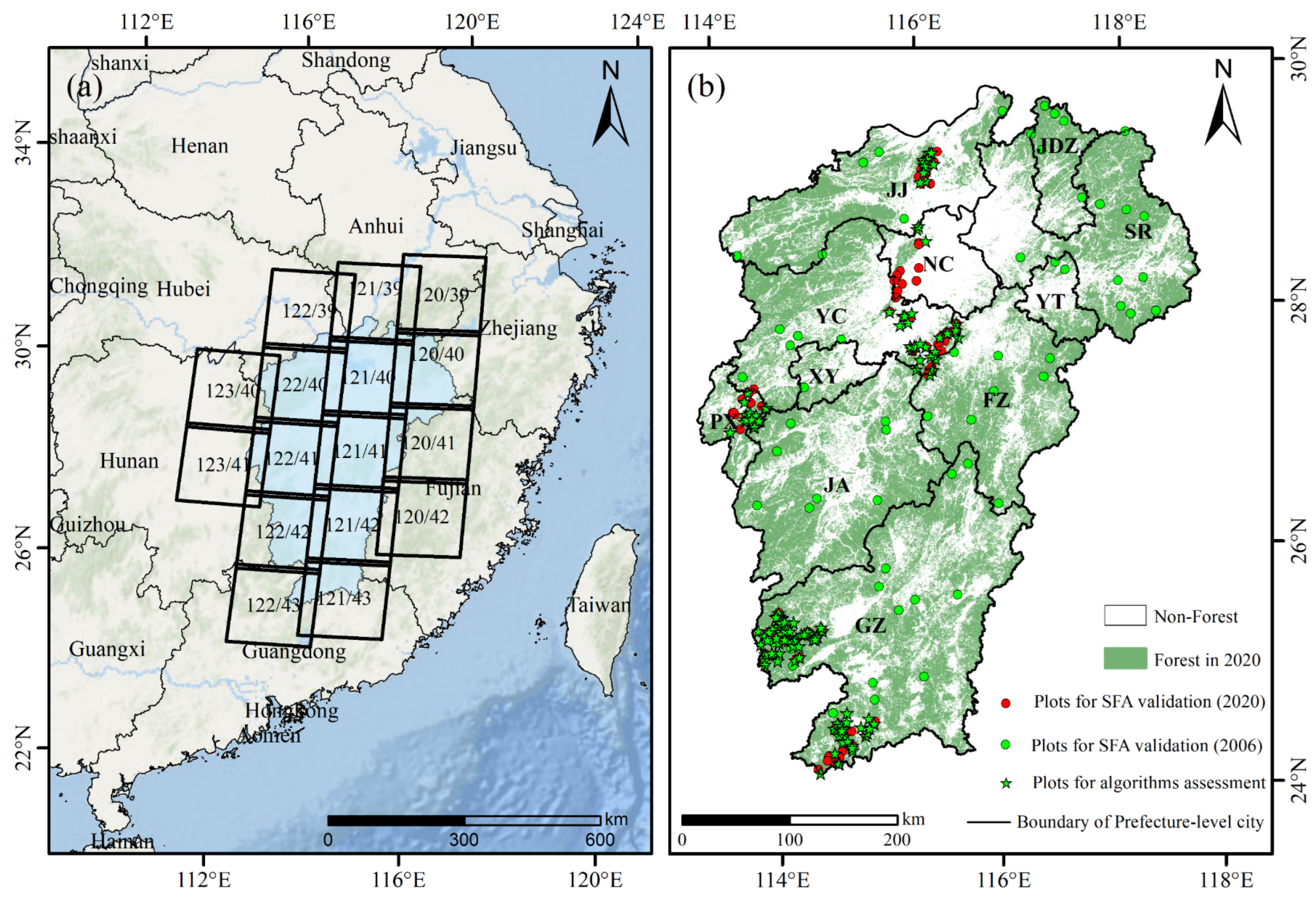
2.2.2. Forest Samples for Assessment of Algorithms and Ensemble Models and Validation of SFA Map
2.2.3. Land Cover Datasets
2.2.4. Statistical Data for the Area of Artificial Afforestation
2.2.5. Auxiliary Data
2.3. Methods
2.3.1. Detecting Forest Regrowth Time Using Time-Series Change Detection Algorithms
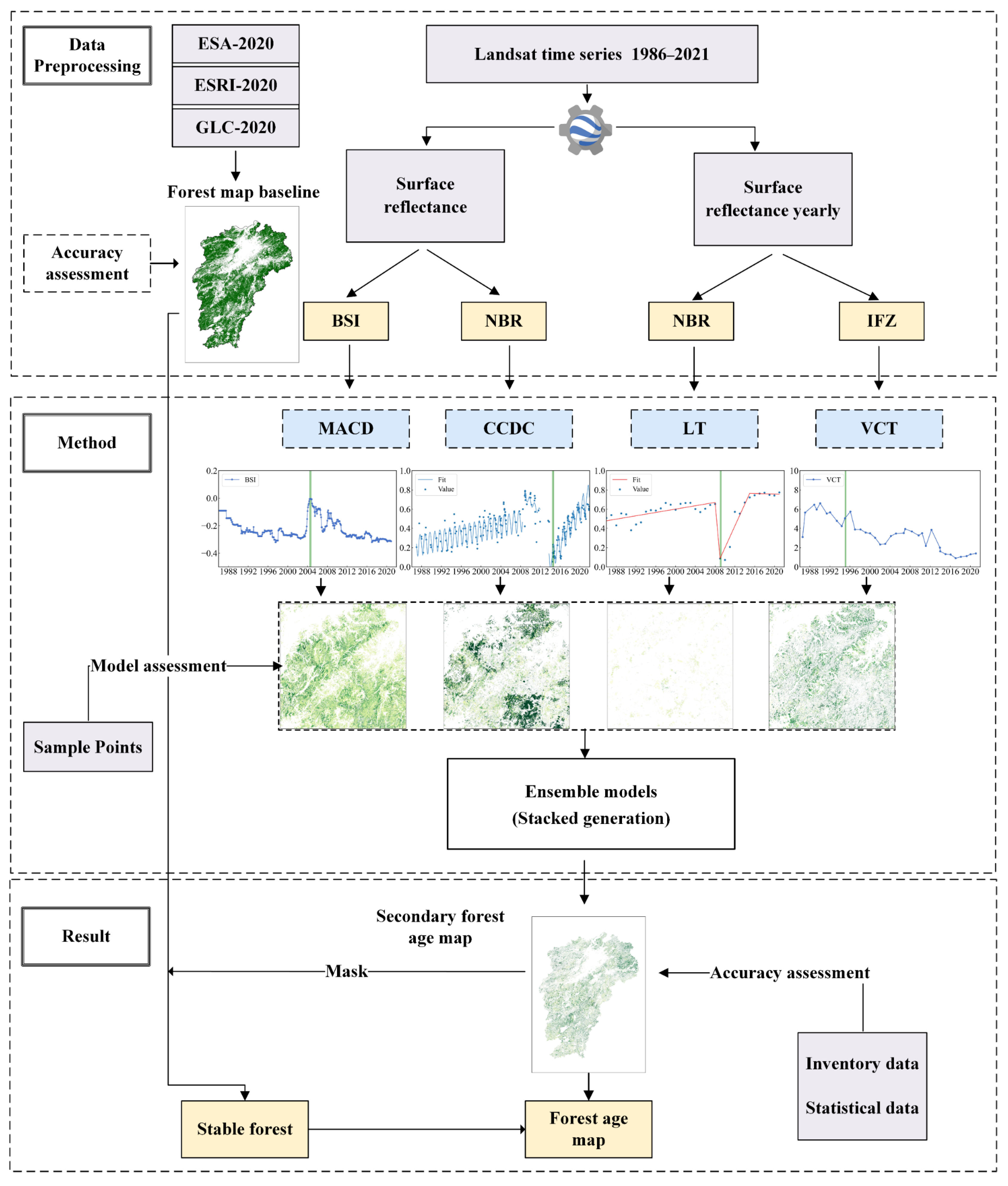
- Moving average change detection (MACD) is a thresholding method in which changes are defined as large deviations from the set threshold. In the present study, MACD considered the moving averages of multiple observations (often three times or more), using all Landsat data (high frequency) to remove abnormal observations by averaging adjacent observations. MACD uses the bare soil index (BSI) [45]. The threshold for detecting forest regrowth was set as −0.026, determined from the 95% confidence interval according to the secondary forest samples;
- Continuous Change Detection and Classification (CCDC) [38] was used to detect the final change. The normalized burn ratio (NBR) [60] was used as the detection index, aided by the GEE-CCDC-Tools repository (https://gee-ccdc-tools.readthedocs.io/en/latest/# (accessed on 1 July 2022)) [61];
- LandTrendr (LT) was used to define the forest recovery time based on the property of the recovery trend in LT. This method identifies gradual changes (mainly recovery) in time series by using temporal segmentation and linear regression [36,37]. Yearly surface reflection (SR) composites for input into the LT and VCT algorithms were obtained using the best available pixel (BAP) method, thereby overcoming the influences of cloud and data noise [62]. The NBR was used as the main change index due to its direct response to forest change [63,64];
- Vegetation Change Tracker (VCT) [34,35] was used to detect forest regrowth based on the integrated forest Z-score (IFZ) threshold. Forests were defined as areas in which the IFZ for a pixel was less than 4.8 for two consecutive years. VCT is an offline and univariate approach requiring considerable computing resources. Therefore, the online VCT was implemented in the present study due to the need for more convenience at the regional level. The IFZ was calculated using the annual cloud-free composite SR (medium frequency) and input into the VCT algorithm to track forest changes at each pixel [65]. The 95% confidence interval was used to determine a VCT threshold of 4.8.
2.3.2. Proposing an Ensemble Model for More Accurate Estimation of SFA
2.3.3. Accuracy Assessment of SFA Acquired from Algorithms and Ensemble Models
2.3.4. Evaluation of the SFA Map
3. Results
3.1. Accuracy Assessment of SFA Acquired by the Four Individual Algorithms and Ensemble Models
3.2. Validation of the SFA Map
3.3. Spatial and Temporal Distributions of SFA
3.4. Topographical Characteristics of SFA
4. Discussion
4.1. Differences between the Change Detection Algorithms
4.2. Advantages and Limitations of the Proposed Method
4.3. Implications of the SFA Map Produced in the Present Study
5. Conclusions
Author Contributions
Funding
Data Availability Statement
Conflicts of Interest
Appendix A
| Data Name | Objective | Period | Spatial Resolution | Sources/Providers |
|---|---|---|---|---|
| Landsat Collection 1 Level-1 | Detecting forest regrowth | 1986–2021 | 30 m | United States Geological Survey (USGS)/GEE [49] |
| World Cover 2020 | Generating the basic forest map | 2020 | 10 m | [55] |
| ESRI 2020 Land Cover | 2020 | 10 m | [56] | |
| GlobeLand 30 | 2020 | 30 m | [54] | |
| First group of forest samples | Assessment of algorithms and ensembles | 2020 | — | Jiangxi Provincial Department of Forestry |
| Second group of forest samples | Validation of the SFA map | 2020/2006 | — | Jiangxi Provincial Department of Forestry |
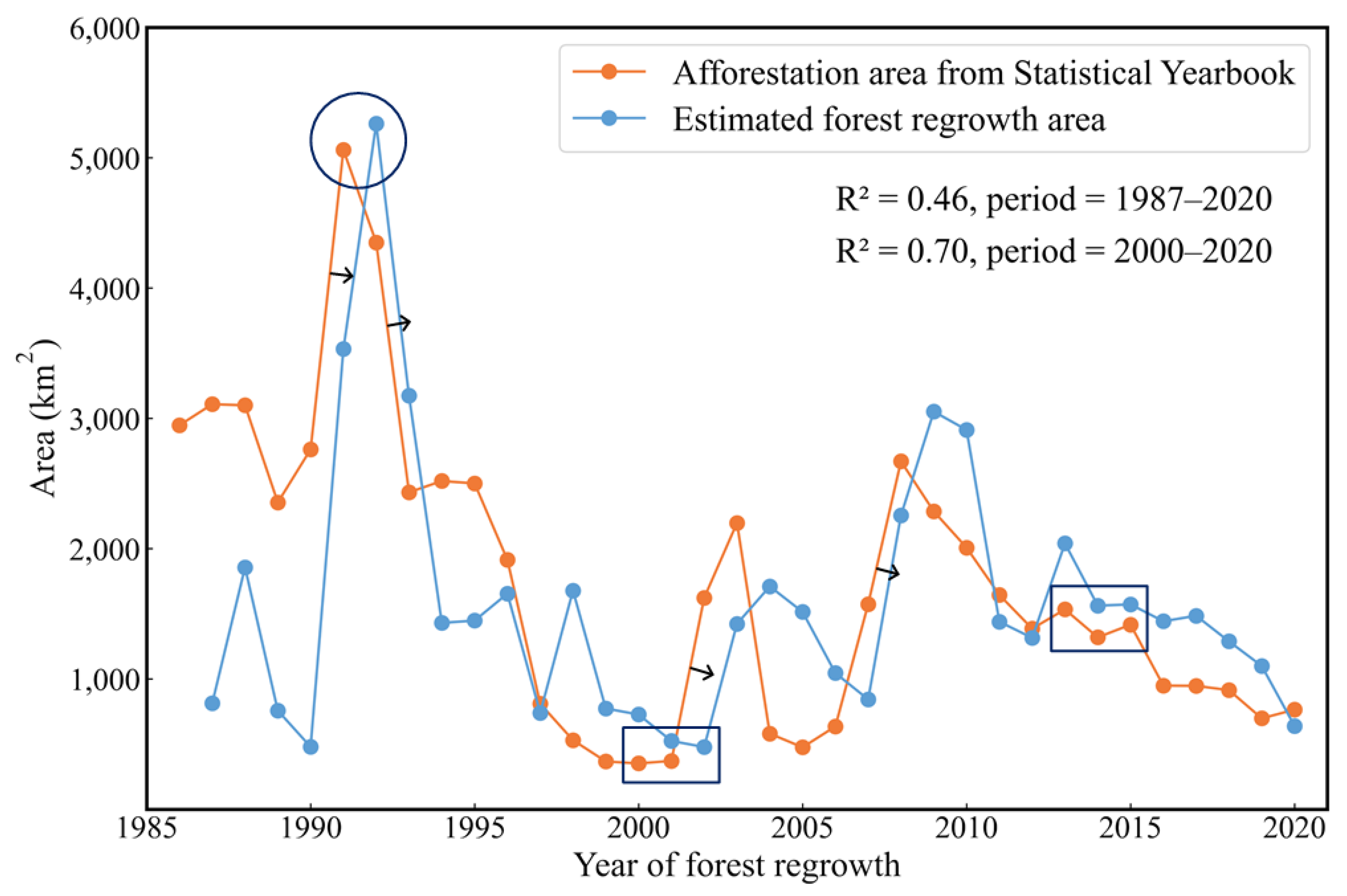
| Statistical data for the artificial afforestation area | Comparison with the SFA map | 1986–2020 | — | Jiangxi Provincial Bureau of Statistics/Jiangxi Provincial Department of Forestry |
| Global map of planting years of plantations (GPYP) | 1987–2019 | 30 m | [58] | |
| NASA Shuttle Radar Topography Mission (SRTM) | Spatial pattern | 2010 | 30 m | [57] |
| Scheme | Omission Rate (%) | Commission Rate (%) | Scheme | Omission Rate (%) | Commission Rate (%) |
|---|---|---|---|---|---|
| CCDC | 37.65 | 15.69 | CCDC + VCT + LT | 23.53 | 13.85 |
| VCT | 49.41 | 16.28 | CCDC + VCT + MACD | 3.53 | 31.71 |
| LT | 93.75 | 16.67 | VCT + CCDC | 23.71 | 17.19 |
| MACD | 7.29 | 38.20 | VCT + CCDC + MACD | 5.88 | 48.75 |
| CCDC + VCT | 24.71 | 14.06 |
References
- Xie, X.Y.; Li, A.N.; Jin, H.A. The Simulation Models of the Forest Carbon Cycle on a Large Scale: A Review. Shengtai Xuebao/Acta Ecol. Sin. 2018, 38, 41–54. [Google Scholar] [CrossRef]
- Canadell, J.G.; Le Quéré, C.; Raupach, M.R.; Field, C.B.; Buitenhuis, E.T.; Ciais, P.; Conway, T.J.; Gillett, N.P.; Houghton, R.A.; Marland, G. Contributions to Accelerating Atmospheric CO2 Growth from Economic Activity, Carbon Intensity, and Efficiency of Natural Sinks. Proc. Natl. Acad. Sci. USA 2007, 104, 18866–18870. [Google Scholar] [CrossRef] [PubMed] [Green Version]
- Zhao, X.; Ma, X.; Chen, B.; Shang, Y.; Song, M. Challenges toward Carbon Neutrality in China: Strategies and Countermeasures. Resour. Conserv. Recycl. 2022, 176, 105959. [Google Scholar] [CrossRef]
- Rocha, R.; Ovaskainen, O.; López-Baucells, A.; Farneda, F.Z.; Sampaio, E.M.; Bobrowiec, P.E.D.; Cabeza, M.; Palmeirim, J.M.; Meyer, C.F.J. Secondary Forest Regeneration Benefits Old-Growth Specialist Bats in a Fragmented Tropical Landscape. Sci. Rep. 2018, 8, 3819. [Google Scholar] [CrossRef]
- Chen, Z.; Huang, M.; Xiao, C.; Qi, S.; Du, W.; Zhu, D.; Altan, O. Integrating Remote Sensing and Spatiotemporal Analysis to Characterize Artificial Vegetation Restoration Suitability in Desert Areas: A Case Study of Mu Us Sandy Land. Remote Sens. 2022, 14, 4736. [Google Scholar] [CrossRef]
- Poorter, L.; Bongers, F.; Aide, T.M.; Almeyda Zambrano, A.M.; Balvanera, P.; Becknell, J.M.; Boukili, V.; Brancalion, P.H.S.; Broadbent, E.N.; Chazdon, R.L.; et al. Biomass Resilience of Neotropical Secondary Forests. Nature 2016, 530, 211–214. [Google Scholar] [CrossRef] [PubMed]
- Fehse, J.; Hofstede, R.; Aguirre, N.; Paladines, C.; Kooijman, A.; Sevink, J. High Altitude Tropical Secondary Forests: A Competitive Carbon Sink? For. Ecol. Manag. 2002, 163, 9–25. [Google Scholar] [CrossRef]
- Chave, J.; Andalo, C.; Brown, S.; Cairns, M.A.; Chambers, J.Q.; Eamus, D.; Fölster, H.; Fromard, F.; Higuchi, N.; Kira, T.; et al. Tree Allometry and Improved Estimation of Carbon Stocks and Balance in Tropical Forests. Oecologia 2005, 145, 87–99. [Google Scholar] [CrossRef]
- Chen, J.; Chen, W.; Liu, J.; Cihlar, J.; Gray, S. Annual Carbon Balance of Canada’s Forests during 1895–1996. Glob. Biogeochem. Cycles 2000, 14, 839–849. [Google Scholar] [CrossRef]
- He, L.; Chen, J.M.; Zhang, S.; Gomez, G.; Pan, Y.; McCullough, K.; Birdsey, R.; Masek, J.G. Normalized Algorithm for Mapping and Dating Forest Disturbances and Regrowth for the United States. Int. J. Appl. Earth Obs. Geoinf. 2011, 13, 236–245. [Google Scholar] [CrossRef]
- Ju, W.M.; Chen, J.M.; Harvey, D.; Wang, S. Future Carbon Balance of China’s Forests under Climate Change and Increasing CO2. J. Environ. Manag. 2007, 85, 538–562. [Google Scholar] [CrossRef] [PubMed]
- Turner, D.P.; Ritts, W.D.; Law, B.E.; Cohen, W.B.; Yang, Z.; Hudiburg, T.; Campbell, J.L.; Duane, M. Scaling Net Ecosystem Production and Net Biome Production over a Heterogeneous Region in the Western United States. Biogeosciences 2007, 4, 597–612. [Google Scholar] [CrossRef] [Green Version]
- Wang, S.; Zhou, L.; Chen, J.; Ju, W.; Feng, X.; Wu, W. Relationships between Net Primary Productivity and Stand Age for Several Forest Types and Their Influence on China’s Carbon Balance. J. Environ. Manag. 2011, 92, 1651–1662. [Google Scholar] [CrossRef] [PubMed]
- Wang, S.; Chen, J.M.; Ju, W.M.; Feng, X.; Chen, M.; Chen, P.; Yu, G. Carbon Sinks and Sources in China’s Forests during 1901–2001. J. Environ. Manag. 2007, 85, 524–537. [Google Scholar] [CrossRef]
- Zhang, F.; Chen, J.M.; Pan, Y.; Birdsey, R.A.; Shen, S.; Ju, W.; He, L. Attributing Carbon Changes in Conterminous U.S. Forests to Disturbance and Non-Disturbance Factors from 1901 to 2010. J. Geophys. Res. Biogeosci. 2015, 117, 109–119. [Google Scholar] [CrossRef] [Green Version]
- Chambers, J.Q.; Asner, G.P.; Morton, D.C.; Anderson, L.O.; Palace, M.; Saatchi, S.S.; Espı, F.D.B. Regional Ecosystem Structure and Function: Ecological Insights from Remote Sensing of Tropical Forests. Trends Ecol. Evol. 2007, 22, 411–423. [Google Scholar] [CrossRef] [PubMed]
- Dai, M.; Zhou, T.; Ynag, L.; Jia, G. Spatial pattern of forest ages in China retrieved from national-level inventory and remotes ensing imageries. Geogr. Res. 2011, 30, 172–184. [Google Scholar] [CrossRef]
- Kimes, D.S.; Nelson, R.F.; Salas, W.A.; Skole, D.L. Mapping Secondary Tropical Forest and Forest Age from SPOT HRV Data. Int. J. Remote Sens. 1999, 20, 3625–3640. [Google Scholar] [CrossRef]
- Yu, Z.; Zhao, H.; Liu, S.; Zhou, G.; Fang, J.; Yu, G.; Tang, X.; Wang, W.; Yan, J.; Wang, G.; et al. Mapping Forest Type and Age in China’s Plantations. Sci. Total Environ. 2020, 744, 140790. [Google Scholar] [CrossRef]
- Zhang, C.; Ju, W.; Chen, J.M.; Li, D.; Wang, X.; Fan, W.; Li, M.; Zan, M. Mapping Forest Stand Age in China Using Remotely Sensed Forest Height and Observation Data. J. Geophys. Res. Biogeosci. 2014, 119, 1163–1179. [Google Scholar] [CrossRef]
- Zhang, Y.; Yao, Y.; Wang, X.; Liu, Y.; Piao, S. Mapping Spatial Distribution of Forest Age in China. Earth Space Sci. 2017, 4, 108–116. [Google Scholar] [CrossRef]
- Chen, B.; Xiao, X.; Wu, Z.; Yun, T.; Kou, W.; Ye, H.; Lin, Q.; Doughty, R.; Dong, J.; Ma, J.; et al. Identifying Establishment Year and Pre-Conversion Land Cover of Rubber Plantations on Hainan Island, China Using Landsat Data during 1987–2015. Remote Sens. 2018, 10, 1240. [Google Scholar] [CrossRef] [Green Version]
- Prates-Clark, C.d.C.; Lucas, R.M.; dos Santos, J.R. Implications of Land-Use History for Forest Regeneration in the Brazilian Amazon. Can. J. Remote Sens. 2009, 35, 534–553. [Google Scholar] [CrossRef]
- Silva Junior, C.H.L.; Heinrich, V.H.A.; Freire, A.T.G.; Broggio, I.S.; Rosan, T.M.; Doblas, J.; Anderson, L.O.; Rousseau, G.X.; Shimabukuro, Y.E.; Silva, C.A.; et al. Benchmark Maps of 33 Years of Secondary Forest Age for Brazil. Sci. Data 2020, 7, 269. [Google Scholar] [CrossRef]
- Carreiras, J.M.B.; Jones, J.; Lucas, R.M.; Shimabukuro, Y.E. Mapping Major Land Cover Types and Retrieving the Age of Secondary Forests in the Brazilian Amazon by Combining Single-Date Optical and Radar Remote Sensing Data. Remote Sens. Environ. 2017, 194, 16–32. [Google Scholar] [CrossRef] [Green Version]
- Dibs, H.; Idrees, M.O.; Alsalhin, G.B.A. Hierarchical Classification Approach for Mapping Rubber Tree Growth Using Per-Pixel and Object-Oriented Classifiers with SPOT-5 Imagery. Egypt. J. Remote Sens. Space Sci. 2017, 20, 21–30. [Google Scholar] [CrossRef]
- Reyes-Palomeque, G.; Dupuy, J.M.; Portillo-Quintero, C.A.; Andrade, J.L.; Tun-Dzul, F.J.; Hernández-Stefanoni, J.L. Mapping Forest Age and Characterizing Vegetation Structure and Species Composition in Tropical Dry Forests. Ecol. Indic. 2021, 120, 106955. [Google Scholar] [CrossRef]
- Xie, S.; Wang, W.; Liu, Q.; Meng, J.; Zhao, T.; Huang, G. Estimation of Forest Stand Parameters Using SPOT-5 Satellite Images and Topographic Information. Forestry 2017, 2017100017. [Google Scholar] [CrossRef] [Green Version]
- Zhang, Q.; Pavlic, G.; Chen, W.; Latifovic, R.; Fraser, R.; Cihlar, J. Deriving Stand Age Distribution in Boreal Forests Using SPOT VEGETATION and NOAA AVHRR Imagery. Remote Sens. Environ. 2004, 91, 405–418. [Google Scholar] [CrossRef]
- Chazdon, R.L.; Broadbent, E.N.; Rozendaal, D.M.A.; Bongers, F.; Zambrano, A.M.A.; Aide, T.M.; Balvanera, P.; Becknell, J.M.; Boukili, V.; Brancalion, P.H.S.; et al. Carbon Sequestration Potential of Second-Growth Forest Regeneration in the Latin American Tropics. Sci. Adv. 2016, 2, e1501639. [Google Scholar] [CrossRef] [Green Version]
- Chen, G.; Thill, J.-C.; Anantsuksomsri, S.; Tontisirin, N.; Tao, R. Stand Age Estimation of Rubber (Hevea brasiliensis) Plantations Using an Integrated Pixel- and Object-Based Tree Growth Model and Annual Landsat Time Series. ISPRS J. Photogramm. Remote Sens. 2018, 144, 94–104. [Google Scholar] [CrossRef]
- Razak, J.A.b.A.; Shariff, A.R.b.M.; Ahmad, N.b.; Ibrahim Sameen, M. Mapping Rubber Trees Based on Phenological Analysis of Landsat Time Series Data-Sets. Geocarto Int. 2018, 33, 627–650. [Google Scholar] [CrossRef]
- Awty-Carroll, K.; Bunting, P.; Hardy, A.; Bell, G. An Evaluation and Comparison of Four Dense Time Series Change Detection Methods Using Simulated Data. Remote Sens. 2019, 11, 2779. [Google Scholar] [CrossRef] [Green Version]
- Huang, C.; Goward, S.N.; Masek, J.G.; Thomas, N.; Zhu, Z.; Vogelmann, J.E. An Automated Approach for Reconstructing Recent Forest Disturbance History Using Dense Landsat Time Series Stacks. Remote Sens. Environ. 2010, 114, 183–198. [Google Scholar] [CrossRef]
- Thomas, N.E.; Huang, C.; Goward, S.N.; Powell, S.; Rishmawi, K.; Schleeweis, K.; Hinds, A. Validation of North American Forest Disturbance Dynamics Derived from Landsat Time Series Stacks. Remote Sens. Environ. 2011, 115, 19–32. [Google Scholar] [CrossRef]
- Kennedy, R.E.; Yang, Z.; Cohen, W.B. Detecting Trends in Forest Disturbance and Recovery Using Yearly Landsat Time Series: 1. LandTrendr—Temporal Segmentation Algorithms. Remote Sens. Environ. 2010, 114, 2897–2910. [Google Scholar] [CrossRef]
- Kennedy, R.E.; Yang, Z.; Cohen, W.B.; Pfaff, E.; Braaten, J.; Nelson, P. Spatial and Temporal Patterns of Forest Disturbance and Regrowth within the Area of the Northwest Forest Plan. Remote Sens. Environ. 2012, 122, 117–133. [Google Scholar] [CrossRef]
- Zhu, Z.; Woodcock, C.E. Continuous Change Detection and Classification of Land Cover Using All Available Landsat Data. Remote Sens. Environ. 2014, 144, 152–171. [Google Scholar] [CrossRef] [Green Version]
- Zhao, Z.; Meng, Y.; Yue, A.; Huang, Q.; Kong, Y.; Yuan, Y.; Liu, X.; Lin, L.; Zhang, M. Review of Remotely Sensed Time Series Data for Change Detection. Yaogan Xuebao/J. Remote Sens. 2016, 20, 1110–1125. [Google Scholar] [CrossRef]
- Zhu, Z. Change Detection Using Landsat Time Series: A Review of Frequencies, Preprocessing, Algorithms, and Applications. ISPRS J. Photogramm. Remote Sens. 2017, 130, 370–384. [Google Scholar] [CrossRef]
- Cohen, W.B.; Healey, S.P.; Yang, Z.; Stehman, S.V.; Brewer, C.K.; Brooks, E.B.; Gorelick, N.; Huang, C.; Hughes, M.J.; Kennedy, R.E.; et al. How Similar Are Forest Disturbance Maps Derived from Different Landsat Time Series Algorithms? Forests 2017, 8, 98. [Google Scholar] [CrossRef]
- Healey, S.P.; Cohen, W.B.; Yang, Z.; Kenneth Brewer, C.; Brooks, E.B.; Gorelick, N.; Hernandez, A.J.; Huang, C.; Joseph Hughes, M.; Kennedy, R.E.; et al. Mapping Forest Change Using Stacked Generalization: An Ensemble Approach. Remote Sens. Environ. 2018, 204, 717–728. [Google Scholar] [CrossRef]
- Hislop, S.; Jones, S.; Soto-Berelov, M.; Skidmore, A.; Haywood, A.; Nguyen, T.H. A Fusion Approach to Forest Disturbance Mapping Using Time Series Ensemble Techniques. Remote Sens. Environ. 2019, 221, 188–197. [Google Scholar] [CrossRef]
- Chen, B.; Jin, Y.; Brown, P. Automatic Mapping of Planting Year for Tree Crops with Landsat Satellite Time Series Stacks. ISPRS J. Photogramm. Remote Sens. 2019, 151, 176–188. [Google Scholar] [CrossRef]
- Danylo, O.; Pirker, J.; Lemoine, G.; Ceccherini, G.; See, L.; McCallum, I.; Hadi; Kraxner, F.; Achard, F.; Fritz, S. A Map of the Extent and Year of Detection of Oil Palm Plantations in Indonesia, Malaysia and Thailand. Sci. Data 2021, 8, 96. [Google Scholar] [CrossRef]
- Liu, C.; Huang, H.; Zhang, Q.; Chen, X.; Xu, X.; Xu, H.; Cheng, X. Arctic’s Man-Made Impervious Surfaces Expanded by over Two-Thirds in the 21st Century. Sci. Bull. 2022, 67, 1425–1429. [Google Scholar] [CrossRef]
- Xu, H.; Qi, S.; Li, X.; Gao, C.; Wei, Y.; Liu, C. Monitoring Three-Decade Dynamics of Citrus Planting in Southeastern China Using Dense Landsat Records. Int. J. Appl. Earth Obs. Geoinf. 2021, 103, 102518. [Google Scholar] [CrossRef]
- National Forestry and Grassland Administration. Chinese Forest Resources Report; China Forestry Publishing House: Beijing, China, 2019; ISBN 978-7-5038-9982-9.
- Gorelick, N.; Hancher, M.; Dixon, M.; Ilyushchenko, S.; Thau, D.; Moore, R. Google Earth Engine: Planetary-Scale Geospatial Analysis for Everyone. Remote Sens. Environ. 2017, 202, 18–27. [Google Scholar] [CrossRef]
- Zhu, Z.; Wang, S.; Woodcock, C.E. Remote Sensing of Environment Improvement and Expansion of the Fmask Algorithm: Cloud, Cloud Shadow, and Snow Detection for Landsats 4–7, 8, and Sentinel 2 Images. Remote Sens. Environ. 2015, 159, 269–277. [Google Scholar] [CrossRef]
- Lei, X.D.; Tang, M.P.; Lu, Y.C.; Hong, L.X.; Tian, D.L. Forest Inventory in China: Status and Challenges. Int. For. Rev. 2009, 11, 52–63. [Google Scholar] [CrossRef]
- Xie, X.; Wang, Q.; Dai, L.; Su, D.; Wang, X.; Qi, G.; Ye, Y. Application of China’s National Forest Continuous Inventory Database. Environ. Manag. 2011, 48, 1095–1106. [Google Scholar] [CrossRef] [PubMed]
- Li, Y.; Li, C.; Li, M.; Liu, Z. Influence of Variable Selection and Forest Type on Forest Aboveground Biomass Estimation Using Machine Learning Algorithms. Forests 2019, 10, 1073. [Google Scholar] [CrossRef] [Green Version]
- Jun, C.; Ban, Y.; Li, S. China: Open Access to Earth Land-Cover Map. Nature 2014, 514, 434. [Google Scholar] [CrossRef] [Green Version]
- Zanaga, D.; Van De Kerchove, R.; De Keersmaecker, W.; Souverijns, N.; Brockmann, C.; Quast, R.; Wevers, J.; Grosu, A.; Paccini, A.; Vergnaud, S.; et al. ESA WorldCover 10 m 2020 V100. 2021. Available online: https://doi.org/10.5281/zenodo.5571936 (accessed on 1 May 2022).
- Karra, K.; Kontgis, C.; Statman-Weil, Z.; Mazzariello, J.C.; Mathis, M.; Brumby, S.P. Global Land Use / Land Cover with Sentinel 2 and Deep Learning. In Proceedings of the IEEE International Geoscience and Remote Sensing Symposium IGARSS, Brussels, Belgium, 12–16 July 2021; pp. 4704–4707. [Google Scholar] [CrossRef]
- Farr, T.G.; Rosen, P.A.; Caro, E.; Crippen, R.; Duren, R.; Hensley, S.; Kobrick, M.; Paller, M.; Rodriguez, E.; Roth, L.; et al. The Shuttle Radar Topography Mission. Rev. Geophys. 2007, 45, RG2004. [Google Scholar] [CrossRef] [Green Version]
- Du, Z.; Yu, L.; Yang, J.; Xu, Y.; Chen, B.; Peng, S.; Zhang, T.; Fu, H.; Harris, N.; Gong, P. A Global Map of Planting Years of Plantations. Sci. Data 2022, 9, 141. [Google Scholar] [CrossRef]
- Diao, J.; Feng, T.; Li, M.; Zhu, Z.; Liu, J.; Biging, G.; Zheng, G.; Shen, W.; Wang, H.; Wang, J.; et al. Use of Vegetation Change Tracker, Spatial Analysis, and Random Forest Regression to Assess the Evolution of Plantation Stand Age in Southeast China. Ann. For. Sci. 2020, 77, 27. [Google Scholar] [CrossRef]
- López García, M.J.; Caselles, V. Mapping Burns and Natural Reforestation Using Thematic Mapper Data. Geocarto Int. 1991, 6, 31–37. [Google Scholar] [CrossRef]
- Arévalo, P.; Bullock, E.L.; Woodcock, C.E.; Olofsson, P. A Suite of Tools for Continuous Land Change Monitoring in Google Earth Engine. Front. Clim. 2020, 2, 576–740. [Google Scholar] [CrossRef]
- White, J.C.; Wulder, M.A.; Hobart, G.W.; Luther, J.E.; Hermosilla, T.; Griffiths, P.; Coops, N.C.; Hall, R.J.; Hostert, P.; Dyk, A.; et al. Pixel-Based Image Compositing for Large-Area Dense Time Series Applications and Science. Can. J. Remote Sens. 2014, 40, 192–212. [Google Scholar] [CrossRef] [Green Version]
- Shen, W.; Li, M.; Wei, A. Spatio-Temporal Variations in Plantation Forests’ Disturbance and Recovery of Northern Guangdong Province Using Yearly Landsat Time Series Observations (1986–2015). Chin. Geogr. Sci. 2017, 27, 600–613. [Google Scholar] [CrossRef]
- Cohen, W.B.; Yang, Z.; Healey, S.P.; Kennedy, R.E.; Gorelick, N. A LandTrendr Multispectral Ensemble for Forest Disturbance Detection. Remote Sens. Environ. 2018, 205, 131–140. [Google Scholar] [CrossRef]
- Hu, S.Y.; Pang, Y.; Meng, S.L.; Yue, C.R. Annual Forest Disturbance Detection Using Time Series Landsat 8 OLI Data. For. Res. 2020, 33, 65–72. [Google Scholar] [CrossRef]
- Zhou, D.; Liu, S.; Oeding, J.; Zhao, S. Forest Cutting and Impacts on Carbon in the Eastern United States. Sci. Rep. 2013, 3, 3547. [Google Scholar] [CrossRef] [PubMed] [Green Version]
- Hua, J.; Chen, G.; Yu, L.; Ye, Q.; Jiao, H.; Luo, X. Improved Mapping of Long-Term Forest Disturbance and Recovery Dynamics in the Subtropical China Using All Available Landsat Time-Series Imagery on Google Earth Engine Platform. IEEE J. Sel. Top. Appl. Earth Obs. Remote Sens. 2021, 14, 2754–2768. [Google Scholar] [CrossRef]
- Zhang, Y.; Shen, W.; Li, M.; Lv, Y. Integrating Landsat Time Series Observations and Corona Images to Characterize Forest Change Patterns in a Mining Region of Nanjing, Eastern China from 1967 to 2019. Remote Sens. 2020, 12, 3191. [Google Scholar] [CrossRef]
- Fang, L.; Yang, J.; Zhang, W.; Zhang, W.; Yan, Q. Combining Allometry and Landsat-Derived Disturbance History to Estimate Tree Biomass in Subtropical Planted Forests. Remote Sens. Environ. 2019, 235, 111423. [Google Scholar] [CrossRef]
- Zhu, Z.; Woodcock, C.E.; Holden, C.; Yang, Z. Generating Synthetic Landsat Images Based on All Available Landsat Data: Predicting Landsat Surface Reflectance at Any given Time. Remote Sens. Environ. 2015, 162, 67–83. [Google Scholar] [CrossRef]
- Du, Y.; Li, M.; Fan, W.; Wang, B. Estimation of Forest Stand Age Based on GWR Model and Forest Fire Remote Sensing Data. Sci. Silvae Sin. 2019, 55, 184–194. [Google Scholar] [CrossRef]
- Cutler, D.R.; Edwards, T.C.; Beard, K.H.; Cutler, A.; Hess, K.T.; Gibson, J.; Lawler, J.J. Random forests for classification in ecology. Ecology 2007, 88, 2783–2792. [Google Scholar] [CrossRef]
- Huang, W.; Min, W.; Ding, J.; Liu, Y.; Hu, Y.; Ni, W.; Shen, H. Forest Height Mapping Using Inventory and Multi-Source Satellite Data over Hunan Province in Southern China. For. Ecosyst. 2022, 9, 100006. [Google Scholar] [CrossRef]
- Peng, D.; Zhang, H.; Liu, L.; Huang, W.; Huete, A.R.; Zhang, X.; Wang, F.; Yu, L.; Xie, Q.; Wang, C.; et al. Estimating the Aboveground Biomass for Planted Forests Based on Stand Age and Environmental Variables. Remote Sens. 2019, 11, 2270. [Google Scholar] [CrossRef] [Green Version]
- Pugh, T.A.M.; Lindeskog, M.; Smith, B.; Poulter, B.; Arneth, A.; Haverd, V.; Calle, L. Role of Forest Regrowth in Global Carbon Sink Dynamics. Proc. Natl. Acad. Sci. USA 2019, 116, 4382–4387. [Google Scholar] [CrossRef] [PubMed] [Green Version]


| Reference Data Name | Type | Number | Selection Criteria | Properties | Purpose | Source/Provider |
|---|---|---|---|---|---|---|
| First group | Forest patch (Linban in 2020) | 132 | Area ≥ 4500 m2 Length ≥ 60 m Width ≥ 60 m | 85 secondary forest points (age ≤ 34) 47 stable forest points (age ≥ 40) | Assessment of four individual algorithms and five ensemble models | Seventh Jiangxi Province Forest Resources Second Class Survey (FRSS) (http://ly.jiangxi.gov.cn/ (accessed on 1 May 2022)) |
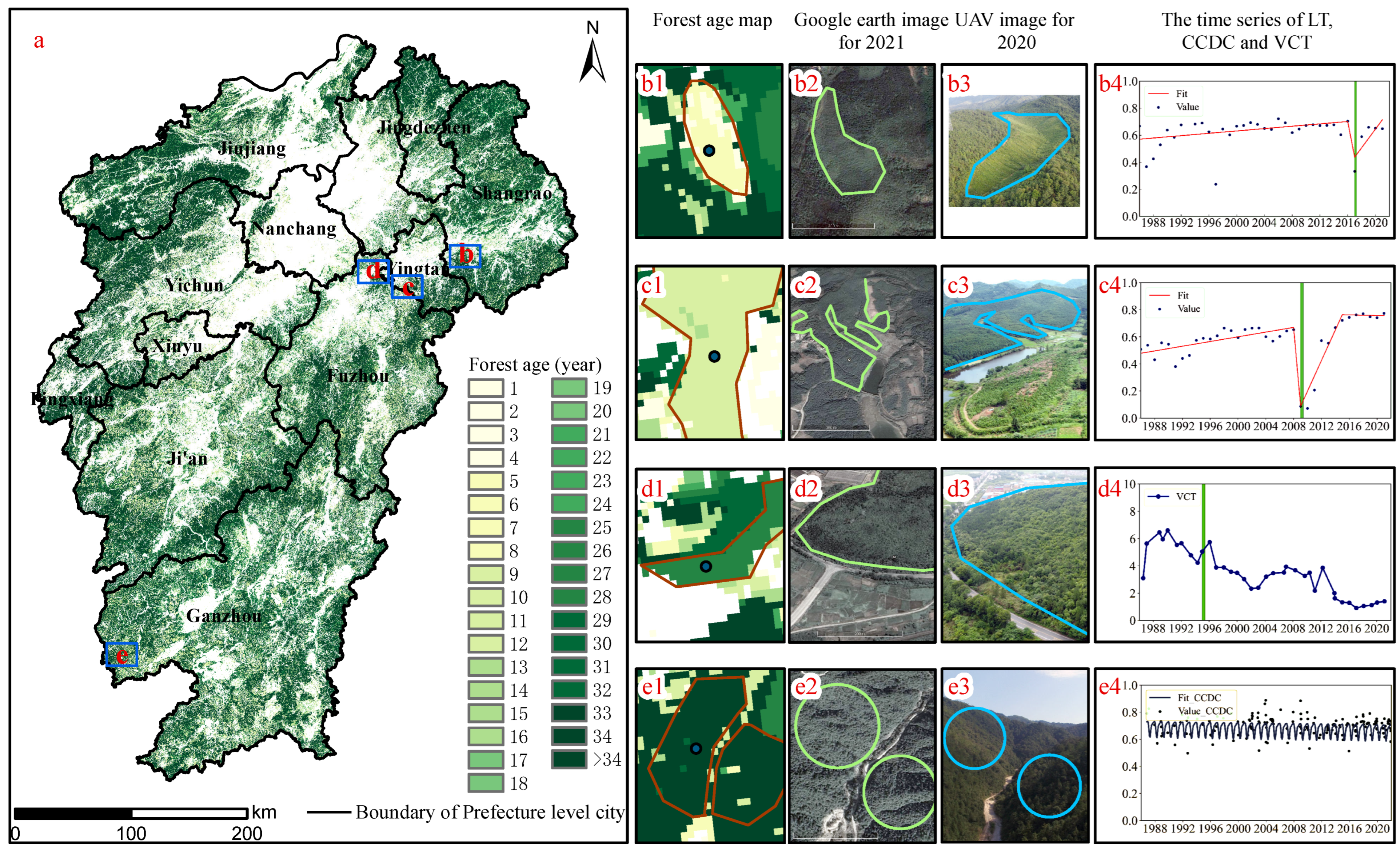
| Second group | Forest patch (Linban in 2020) | 65 | Area ≥ 4500 m2 Length ≥ 60 m Width ≥ 60 m | Age ≤ 34 | Validation of SFA map | Seventh FRSS |
| Forest plots in 2006 | 95 | 25.82 m × 25.82 m (random sample) | Age ≤ 19 | Sixth National Forest Resources Inventory (NFRI) (http://ly.jiangxi.gov.cn/ (accessed on 1 May 2022)) |
| Algorithm Name | Temporal Frequency | Change Index | Parameter | Category | References |
|---|---|---|---|---|---|
| Moving average change detection (MACD) | All available Landsat data (high frequency) | BSI | Windows = 12 Threshold = −0.026 | Threshold | [45] |
| Continuous Change Detection and Classification (CCDC) | All available Landsat data (high frequency) | NBR | minObservations = 6 chiSquareProbability = 0.99 minNumOfYearsScaler = 1.33 dateFormat = 1 lambda = 0.002 maxIterations = 10,000 | Statistical boundary | [38] |
| Vegetation Change Tracker (VCT) | Medium frequency (06.01–10.20) | IFZ | Threshold = 4.8 | Threshold | [34] |
| LandTrendr (LT) | Medium frequency (06.01–10.20) | NBR | maxSegments = 6 spikeThreshold = 0.9 vertexCountOvershoot = 3 recoveryThreshold = 0.25 pvalThreshold = 0.05 bestModelProportion = 0.75 minObservations = 6 | Regression | [36,37] |
Disclaimer/Publisher’s Note: The statements, opinions and data contained in all publications are solely those of the individual author(s) and contributor(s) and not of MDPI and/or the editor(s). MDPI and/or the editor(s) disclaim responsibility for any injury to people or property resulting from any ideas, methods, instructions or products referred to in the content. |
© 2023 by the authors. Licensee MDPI, Basel, Switzerland. This article is an open access article distributed under the terms and conditions of the Creative Commons Attribution (CC BY) license (https://creativecommons.org/licenses/by/4.0/).
Share and Cite
Zhang, S.; Yu, J.; Xu, H.; Qi, S.; Luo, J.; Huang, S.; Liao, K.; Huang, M. Mapping the Age of Subtropical Secondary Forest Using Dense Landsat Time Series Data: An Ensemble Model. Remote Sens. 2023, 15, 2067. https://doi.org/10.3390/rs15082067
Zhang S, Yu J, Xu H, Qi S, Luo J, Huang S, Liao K, Huang M. Mapping the Age of Subtropical Secondary Forest Using Dense Landsat Time Series Data: An Ensemble Model. Remote Sensing. 2023; 15(8):2067. https://doi.org/10.3390/rs15082067
Chicago/Turabian StyleZhang, Shaoyu, Jun Yu, Hanzeyu Xu, Shuhua Qi, Jin Luo, Shiming Huang, Kaitao Liao, and Min Huang. 2023. "Mapping the Age of Subtropical Secondary Forest Using Dense Landsat Time Series Data: An Ensemble Model" Remote Sensing 15, no. 8: 2067. https://doi.org/10.3390/rs15082067
APA StyleZhang, S., Yu, J., Xu, H., Qi, S., Luo, J., Huang, S., Liao, K., & Huang, M. (2023). Mapping the Age of Subtropical Secondary Forest Using Dense Landsat Time Series Data: An Ensemble Model. Remote Sensing, 15(8), 2067. https://doi.org/10.3390/rs15082067


