Fire Vulnerability, Resilience, and Recovery Rates of Mediterranean Pine Forests Using a 33-Year Time Series of Satellite Imagery
Abstract
:1. Introduction
- (i)
- Calculation of spectral indices to analyze the temporal dynamics of the vegetation spectral response within the designated timeframe (1990–2023).
- (ii)
- Analysis of the vegetation recovery rates in the different delimited zones based on fire severity and recurrence.
- (iii)
- Implementation of the conceptual model, including the analysis and evaluation of resilience after fire and vegetation’s vulnerability to wildfires, based on selected indicators.
2. Materials and Methods
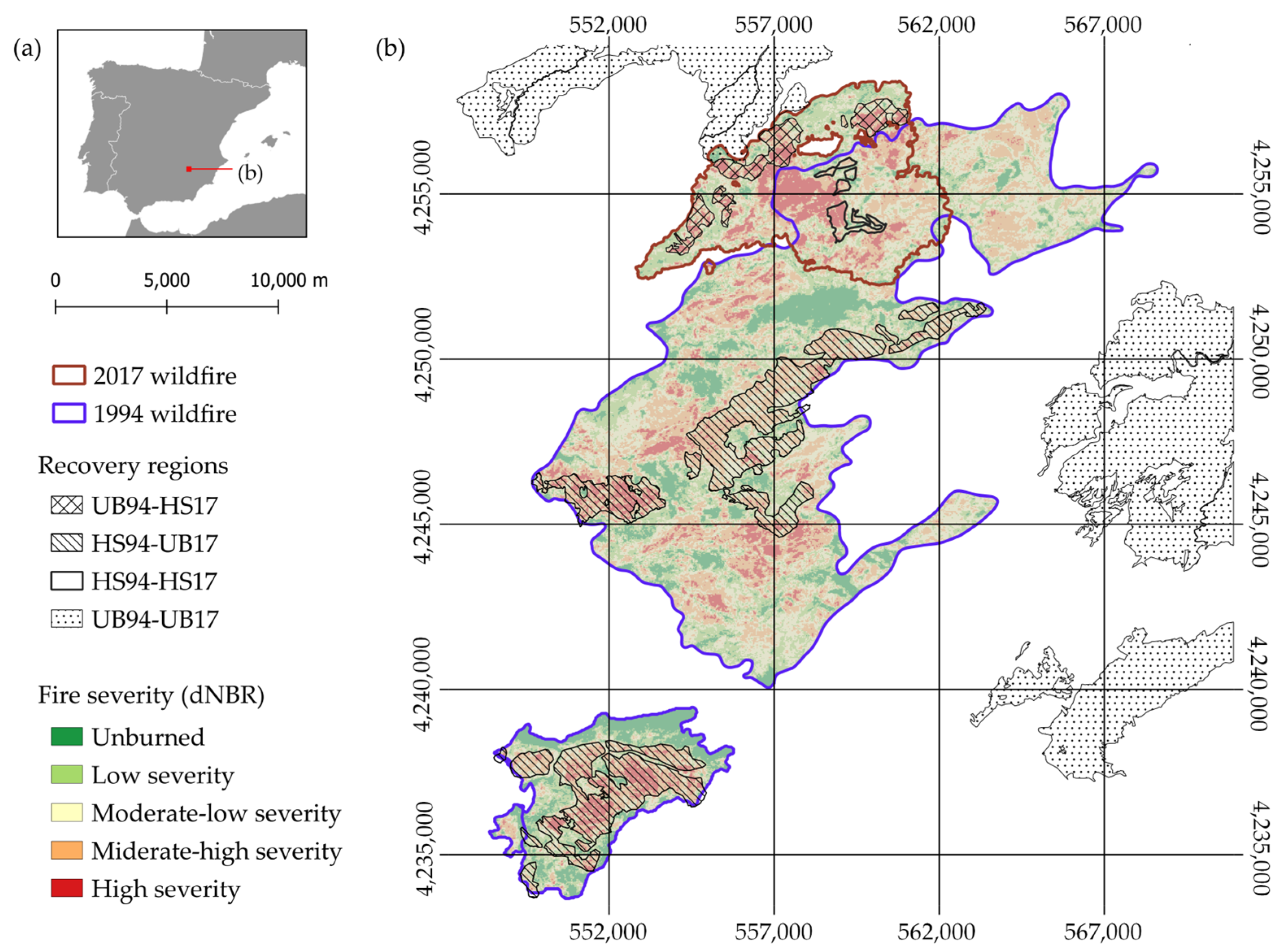
2.1. Study Area
- (i)
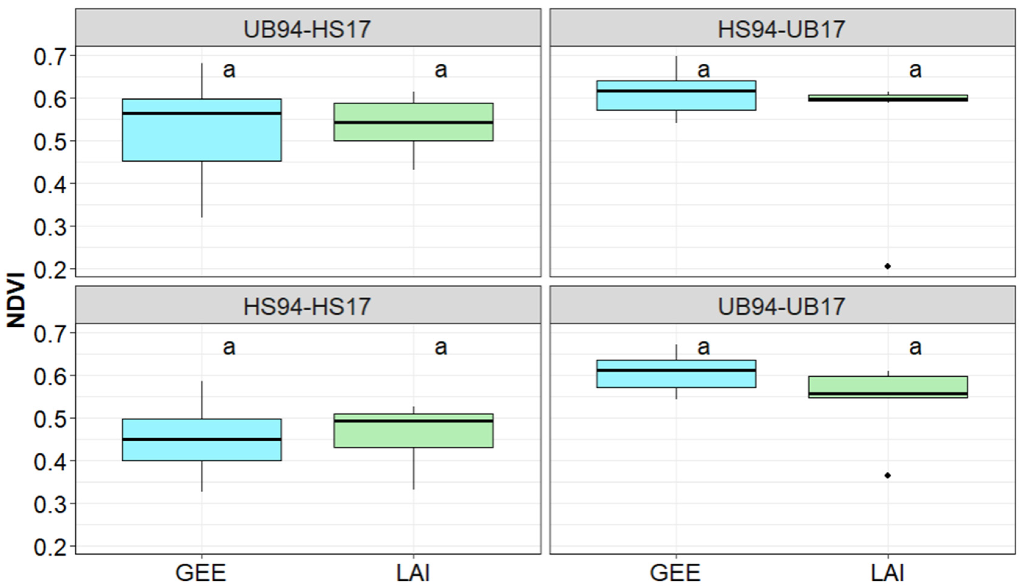
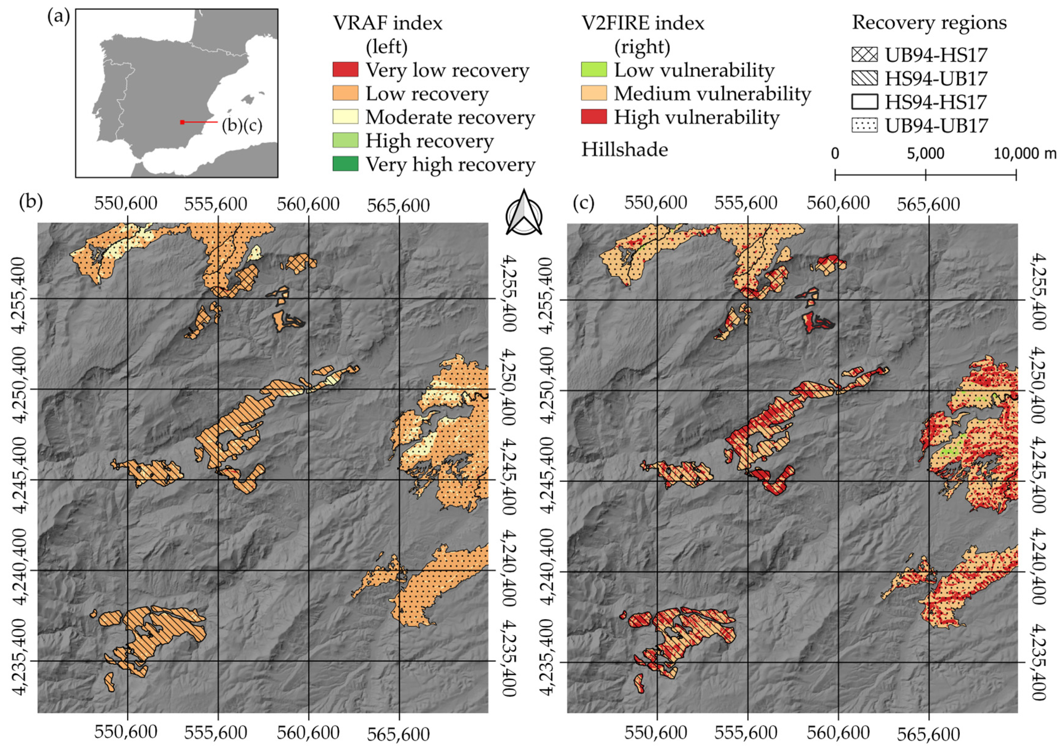
- Zones that were either unburned or underwent very low-intensity burning during the 1994 wildfire but were subjected to high-severity burning in 2017 (UB94-HS17).
- (ii)
- Zones that were subject to high–medium-severity burning in 1994 but remained unburned in 2017 (HS94-UB17).
- (iii)
- Zones that faced high–medium-severity burning during both the 1994 and 2017 fires (HS94-HS17).
- (iv)
- Control zones that remained unburned during both the 1994 and 2017 wildfires (UB94-UB17).
2.2. Datasets
2.2.1. Landsat Collections
2.2.2. Auxiliary Data: Orthophotos and Cartography Sources
2.3. Data Processing
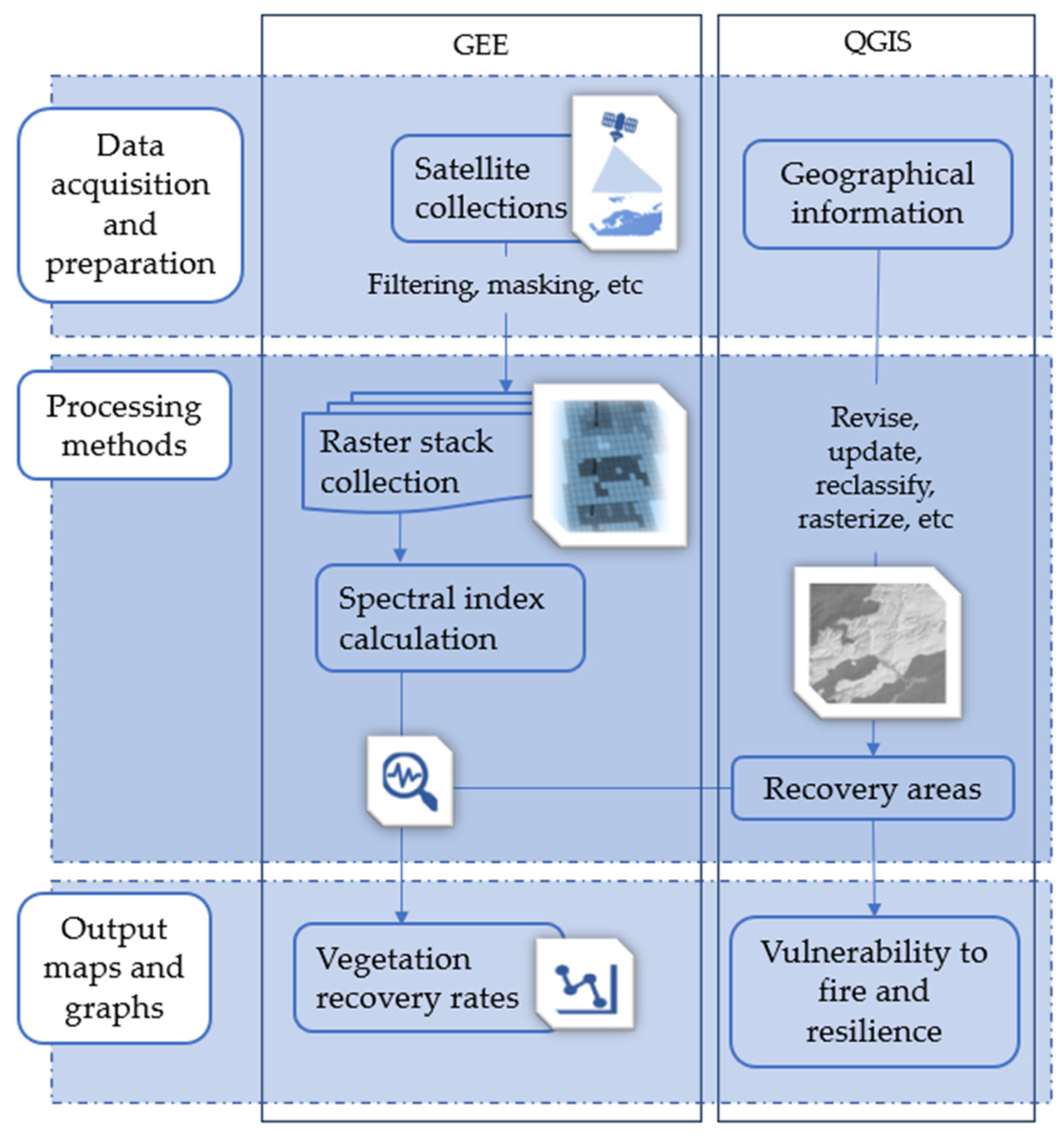
2.3.1. Data Preparation, Processing Methods, and Cloud Computing
| Vegetation Index | Formula | Reference |
|---|---|---|
| NDVI | (NIR − RED)/(NIR + RED) | [60] |
| NDMI | (NIR − SWIR1)/(NIR + SWIR1) | [64,65] |
| NBR | (NIR − SWIR2)/(NIR + SWIR2) | [66] |
| dNBR | dNBR = NBRPrefire − NBRPostfire | [63] |
2.3.2. Model Adjustment and Validation
2.3.3. Mapping Resilience and Vulnerability to Wildfires
- SL is the slope gradient (%).
- A describes the aspect (°).
- FT refers to the fuel types—a simplified representation of a forest ecosystem used to predict and analyze fire behavior. Each FT describes the structure of the vegetation in terms of height, density, load, and continuity [69].
- SN describes the proximity to NATURA 2000 protected sites, such as Special Protected Areas (SPAs) and Special Areas of Conservation (SACs).
- S is the ability of the soil to recover after the fire.
- V refers to the capacity of the vegetation to recover after the fire.
2.4. Statistical Analysis
3. Results
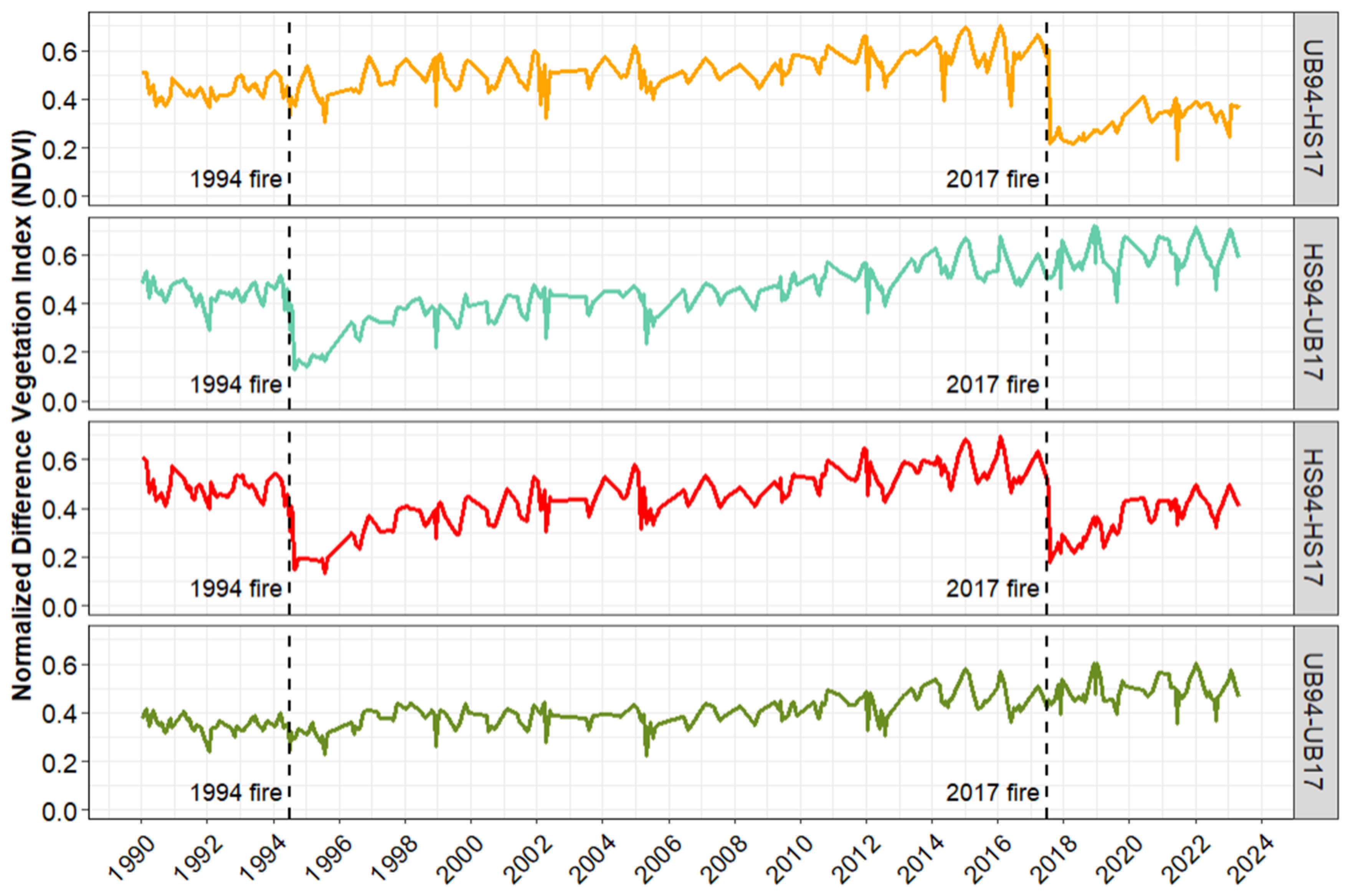
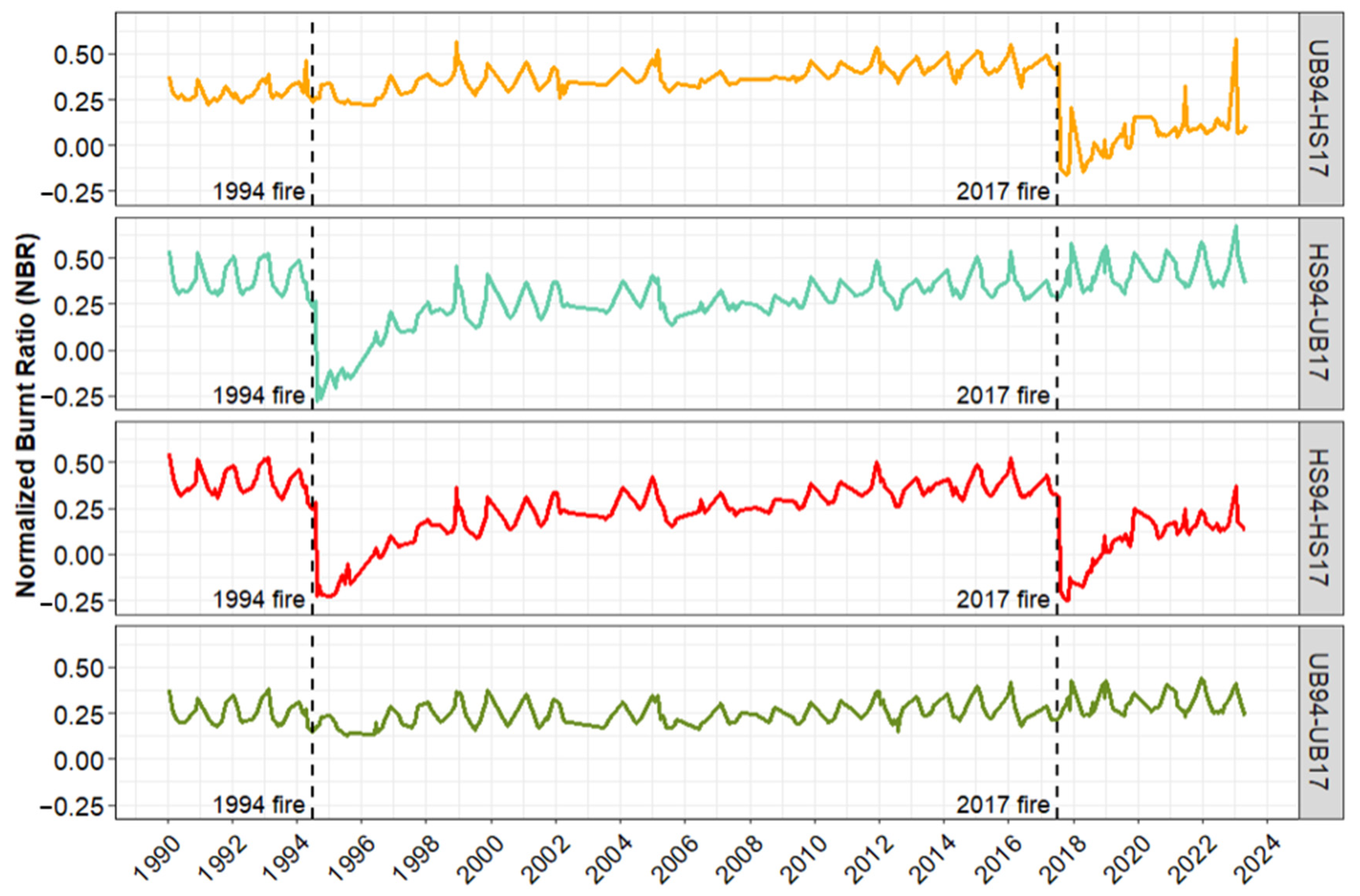
3.1. Vegetation Recovery Dynamic Trends by Region
3.2. Mapping Vegetation’s Resilience and Vulnerability to Wildfires
4. Discussion
4.1. Vegetation Recovery Dynamics by Region
4.2. Mapping Resilience and Vulnerability to Wildfires
5. Conclusions
Author Contributions
Funding
Data Availability Statement
Conflicts of Interest
References
- Halofsky, J.E.; Peterson, D.L.; Harvey, B.J. Changing Wildfire, Changing Forests: The Effects of Climate Change on Fire Regimes and Vegetation in the Pacific Northwest, USA. Fire Ecol. 2020, 16, 4. [Google Scholar] [CrossRef]
- Tedim, F.; Leone, V.; Coughlan, M.; Bouillon, C.; Xanthopoulos, G.; Royé, D.; Correia, F.J.M.; Ferreira, C. 1—Extreme Wildfire Events: The Definition. In Extreme Wildfire Events and Disasters; Tedim, F., Leone, V., McGee, T.K., Eds.; Elsevier: Amsterdam, The Netherlands, 2020; pp. 3–29. ISBN 978-0-12-815721-3. [Google Scholar]
- Castellnou, M. Los Incendios de Sexta Generación Son Más Difíciles de Controlar y Afectan a Medio Planeta. Available online: https://www.lavanguardia.com/ciencia/planeta-tierra/20180817/451324516370/incendios-sexta-generacion-marc-castellnou-cambio-climatico-regenarar-ecosistemas.html (accessed on 13 March 2023).
- Varga, K.; Jones, C.; Trugman, A.; Carvalho, L.M.V.; McLoughlin, N.; Seto, D.; Thompson, C.; Daum, K. Megafires in a Warming World: What Wildfire Risk Factors Led to California’s Largest Recorded Wildfire. Fire 2022, 5, 16. [Google Scholar] [CrossRef]
- Fryirs, K.A.; Zhang, N.; Duxbury, E.; Ralph, T.; Fryirs, K.A.; Zhang, N.; Duxbury, E.; Ralph, T. Rivers up in Smoke: Impacts of Australia’s 2019–2020 Megafires on Riparian Systems. Int. J. Wildland Fire 2022, 31, 720–727. [Google Scholar] [CrossRef]
- Malandra, F.; Vitali, A.; Morresi, D.; Garbarino, M.; Foster, D.E.; Stephens, S.L.; Urbinati, C. Burn Severity Drivers in Italian Large Wildfires. Fire 2022, 5, 180. [Google Scholar] [CrossRef]
- Nolan, R.H.; Anderson, L.O.; Poulter, B.; Varner, J.M. Increasing Threat of Wildfires: The Year 2020 in Perspective: A Global Ecology and Biogeography Special Issue. Glob. Ecol. Biogeogr. 2022, 31, 1898–1905. [Google Scholar] [CrossRef]
- Costafreda-Aumedes, S.; Cardil, A.; Molina, D.M.; Daniel, S.N.; Mavsar, R.; Vega-Garcia, C. Analysis of Factors Influencing Deployment of Fire Suppression Resources in Spain Using Artificial Neural Networks. iForest-Biogeosci. For. 2015, 9, 138. [Google Scholar] [CrossRef]
- Lecina-Diaz, J.; Chas-Amil, M.-L.; Aquilué, N.; Sil, Â.; Brotons, L.; Regos, A.; Touza, J. Incorporating Fire-Smartness into Agricultural Policies Reduces Suppression Costs and Ecosystem Services Damages from Wildfires. J. Environ. Manag. 2023, 337, 117707. [Google Scholar] [CrossRef]
- WWF. Informe Incendios Forestales 2020: El Planeta en Llamas. Available online: https://www.wwf.es/?54921/Informe-incendios-forestales-2020-El-planeta-en-llamas (accessed on 13 March 2023).
- Johnstone, J.F.; McIntire, E.J.B.; Pedersen, E.J.; King, G.; Pisaric, M.J.F. A Sensitive Slope: Estimating Landscape Patterns of Forest Resilience in a Changing Climate. Ecosphere 2010, 1, art14. [Google Scholar] [CrossRef]
- Stevens-Rumann, C.S.; Kemp, K.B.; Higuera, P.E.; Harvey, B.J.; Rother, M.T.; Donato, D.C.; Morgan, P.; Veblen, T.T. Evidence for Declining Forest Resilience to Wildfires under Climate Change. Ecol. Lett. 2018, 21, 243–252. [Google Scholar] [CrossRef]
- Doblas-Miranda, E.; Alonso, R.; Arnan, X.; Bermejo, V.; Brotons, L.; de las Heras, J.; Estiarte, M.; Hódar, J.A.; Llorens, P.; Lloret, F.; et al. A Review of the Combination among Global Change Factors in Forests, Shrublands and Pastures of the Mediterranean Region: Beyond Drought Effects. Glob. Planet. Chang. 2017, 148, 42–54. [Google Scholar] [CrossRef]
- Vaz, P. Wildfire Resilience in Mediterranean Landscapes: A Review; Technical University of Lisbon: Lisbon, Portugal, 2009. [Google Scholar]
- Keeley, J.E. Resilience of Mediterranean Shrub Communities to Fires. In Resilience in Mediterranean-Type Ecosystems; Dell, B., Hopkins, A.J.M., Lamont, B.B., Eds.; Tasks for Vegetation Science; Springer: Dordrecht, The Netherlands, 1986; pp. 95–112. ISBN 978-94-009-4822-8. [Google Scholar]
- Díaz-Delgado, R.; Lloret, F.; Pons, X.; Terradas, J. Satellite Evidence of Decreasing Resilience in Mediterranean Plant Communities after Recurrent Wildfires. Ecology 2002, 83, 2293–2303. [Google Scholar] [CrossRef]
- Fernandez-Manso, A.; Quintano, C.; Roberts, D.A. Burn Severity Influence on Post-Fire Vegetation Cover Resilience from Landsat MESMA Fraction Images Time Series in Mediterranean Forest Ecosystems. Remote Sens. Environ. 2016, 184, 112–123. [Google Scholar] [CrossRef]
- Commission, F. Building Wildfire Resilience into Forest Management Planning; Forestry Commission: Columbia, SC, USA, 2014.
- Olson, R.L.; Bengston, D.N.; DeVaney, L.A.; Thompson, T.A.C. Wildland Fire Management Futures: Insights from a Foresight Panel; General Technical Report NRS-152; U.S. Department of Agriculture, Forest Service, Northern Research Station: Newtown Square, PA, USA, 2015; Volume 152, 44p. [CrossRef]
- Smith, A.M.S.; Kolden, C.A.; Paveglio, T.B.; Cochrane, M.A.; Bowman, D.M.; Moritz, M.A.; Kliskey, A.D.; Alessa, L.; Hudak, A.T.; Hoffman, C.M.; et al. The Science of Firescapes: Achieving Fire-Resilient Communities. BioScience 2016, 66, 130–146. [Google Scholar] [CrossRef]
- Holling, C.S. Resilience and Stability of Ecological Systems. Annu. Rev. Ecol. Syst. 1973, 4, 1–23. [Google Scholar] [CrossRef]
- Tedim, F.; Remelgado, R.; Borges, C.; Carvalho, S.; Martins, J. Exploring the Occurrence of Mega-Fires in Portugal. For. Ecol. Manag. 2013, 294, 86–96. [Google Scholar] [CrossRef]
- Hoegl, M.; Hartmann, S. Bouncing Back, If Not beyond: Challenges for Research on Resilience. Asian Bus. Manag. 2021, 20, 456–464. [Google Scholar] [CrossRef]
- Manyena, S.B. The Concept of Resilience Revisited. Disasters 2006, 30, 434–450. [Google Scholar] [CrossRef]
- Cutter, S.L.; Barnes, L.; Berry, M.; Burton, C.; Evans, E.; Tate, E.; Webb, J. A Place-Based Model for Understanding Community Resilience to Natural Disasters. Glob. Environ. Chang. 2008, 18, 598–606. [Google Scholar] [CrossRef]
- Norris, F.H.; Stevens, S.P.; Pfefferbaum, B.; Wyche, K.F.; Pfefferbaum, R.L. Community Resilience as a Metaphor, Theory, Set of Capacities, and Strategy for Disaster Readiness. Am. J. Community Psychol. 2008, 41, 127–150. [Google Scholar] [CrossRef]
- Reghezza-Zitt, M.; Rufat, S.; Djament-Tran, G.; Le Blanc, A.; Lhomme, S. What Resilience Is Not: Uses and Abuses Cybergeo: European Journal of Geography [Online], Environment, Nature, Landscape, Document 621, Online since 18 October 2012, Connection on 12 May 2024. Available online: http://journals.openedition.org/cybergeo/25554 (accessed on 21 March 2024). [CrossRef]
- Cretney, R. Resilience for Whom? Emerging Critical Geographies of Socio-Ecological Resilience. Geogr. Compass 2014, 8, 627–640. [Google Scholar] [CrossRef]
- Welsh, M. Resilience and Responsibility: Governing Uncertainty in a Complex World. Geogr. J. 2014, 180, 15–26. [Google Scholar] [CrossRef]
- Tierney, K. Resilience and the Neoliberal Project: Discourses, Critiques, Practices—And Katrina. Am. Behav. Sci. 2015, 59, 1327–1342. [Google Scholar] [CrossRef]
- Weichselgartner, J.; Kelman, I. Geographies of Resilience: Challenges and Opportunities of a Descriptive Concept. Prog. Hum. Geogr. 2015, 39, 249–267. [Google Scholar] [CrossRef]
- Southwick, S.M.; Bonanno, G.A.; Masten, A.S.; Panter-Brick, C.; Yehuda, R. Resilience Definitions, Theory, and Challenges: Interdisciplinary Perspectives. Eur. J. Psychotraumatol. 2014, 5, 25338. [Google Scholar] [CrossRef]
- Lindner, M.; Maroschek, M.; Netherer, S.; Kremer, A.; Barbati, A.; Garcia-Gonzalo, J.; Seidl, R.; Delzon, S.; Corona, P.; Kolström, M.; et al. Climate Change Impacts, Adaptive Capacity, and Vulnerability of European Forest Ecosystems. For. Ecol. Manag. 2010, 259, 698–709. [Google Scholar] [CrossRef]
- Duguy, B.; Alloza, J.A.; Baeza, M.J.; De la Riva, J.; Echeverría, M.; Ibarra, P.; Llovet, J.; Cabello, F.P.; Rovira, P.; Vallejo, R.V. Modelling the Ecological Vulnerability to Forest Fires in Mediterranean Ecosystems Using Geographic Information Technologies. Environ. Manag. 2012, 50, 1012–1026. [Google Scholar] [CrossRef]
- Paveglio, T.B.; Prato, T.; Edgeley, C.; Nalle, D. Evaluating the Characteristics of Social Vulnerability to Wildfire: Demographics, Perceptions, and Parcel Characteristics. Environ. Manag. 2016, 58, 534–548. [Google Scholar] [CrossRef]
- Ghorbanzadeh, O.; Blaschke, T.; Gholamnia, K.; Aryal, J. Forest Fire Susceptibility and Risk Mapping Using Social/Infrastructural Vulnerability and Environmental Variables. Fire 2019, 2, 50. [Google Scholar] [CrossRef]
- Bisson, M.; Fornaciai, A.; Coli, A.; Mazzarini, F.; Pareschi, M.T. The Vegetation Resilience After Fire (VRAF) Index: Development, Implementation and an Illustration from Central Italy. Int. J. Appl. Earth Obs. Geoinf. 2008, 10, 312–329. [Google Scholar] [CrossRef]
- Gómez-Sánchez, E.; de las Heras, J.; Lucas-Borja, M.; Moya, D. Assessing fire severity in semi-arid environments: Application in Donceles 2012 wildfire (SE Spain). Rev. Teledetección 2017, 49, 103–113. [Google Scholar] [CrossRef]
- Gorelick, N.; Hancher, M.; Dixon, M.; Ilyushchenko, S.; Thau, D.; Moore, R. Google Earth Engine: Planetary-Scale Geospatial Analysis for Everyone. Remote Sens. Environ. 2017, 202, 18–27. [Google Scholar] [CrossRef]
- Perilla, G.; Mas, J. Google Earth Engine (GEE): Una poderosa herramienta que vincula el potencial de los datos masivos y la eficacia del procesamiento en la nube. Investig. Geográficas 2020, 101, e59929. [Google Scholar] [CrossRef]
- Hansen, M.C.; Potapov, P.V.; Moore, R.; Hancher, M.; Turubanova, S.A.; Tyukavina, A.; Thau, D.; Stehman, S.V.; Goetz, S.J.; Loveland, T.R.; et al. High-Resolution Global Maps of 21st-Century Forest Cover Change. Science 2013, 342, 850–853. [Google Scholar] [CrossRef]
- Ferrara, C.; Salvati, L.; Corona, P.; Romano, R.; Marchi, M. The Background Context Matters: Local-Scale Socioeconomic Conditions and the Spatial Distribution of Wildfires in Italy. Sci. Total Environ. 2019, 654, 43–52. [Google Scholar] [CrossRef]
- Lambrou, N.; Kolden, C.; Loukaitou-Sideris, A.; Anjum, E.; Acey, C. Social Drivers of Vulnerability to Wildfire Disasters: A Review of the Literature. Landsc. Urban Plan. 2023, 237, 104797. [Google Scholar] [CrossRef]
- Higuera, P.E.; Metcalf, A.L.; Miller, C.; Buma, B.; McWethy, D.B.; Metcalf, E.C.; Ratajczak, Z.; Nelson, C.R.; Chaffin, B.C.; Stedman, R.C.; et al. Integrating Subjective and Objective Dimensions of Resilience in Fire-Prone Landscapes. BioScience 2019, 69, 379–388. [Google Scholar] [CrossRef]
- Marey-Perez, M.; Loureiro, X.; Corbelle-Rico, E.J.; Fernández-Filgueira, C. Different Strategies for Resilience to Wildfires: The Experience of Collective Land Ownership in Galicia (Northwest Spain). Sustainability 2021, 13, 4761. [Google Scholar] [CrossRef]
- Marino, E.; Hernando, C.; Planelles, R.; Madrigal, J.; Guijarro, M.; Sebastián, A.; Marino, E.; Hernando, C.; Planelles, R.; Madrigal, J.; et al. Forest Fuel Management for Wildfire Prevention in Spain: A Quantitative SWOT Analysis. Int. J. Wildland Fire 2014, 23, 373–384. [Google Scholar] [CrossRef]
- Moya, D.; Certini, G.; Fulé, P.Z.; Moya, D.; Certini, G.; Fulé, P.Z. Fire Regime and Ecosystem Responses: Adaptive Forest Management in a Changing World (Part 2). Int. J. Wildland Fire 2019, 28, 471–472. [Google Scholar] [CrossRef]
- Kottek, M.; Grieser, J.; Beck, C.; Rudolf, B.; Rubel, F. World Map of the Köppen-Geiger Climate Classification Updated. Meteorol. Z. 2006, 15, 259–263. [Google Scholar] [CrossRef]
- SIGA. Available online: https://sig.mapama.gob.es/siga/ (accessed on 30 November 2022).
- Soil Survey Staff. Keys to Soil Taxonomy, 13th ed.; USDA-Natural Resources Conservation Service: Washington, DC, USA, 2022.
- Masek, J.G.; Vermote, E.F.; Saleous, N.E.; Wolfe, R.; Hall, F.G.; Huemmrich, K.F.; Gao, F.; Kutler, J.; Lim, T.-K. A Landsat Surface Reflectance Dataset for North America, 1990–2000. IEEE Geosci. Remote Sens. Lett. 2006, 3, 68–72. [Google Scholar] [CrossRef]
- Vermote, E.; Justice, C.; Claverie, M.; Franch, B. Preliminary Analysis of the Performance of the Landsat 8/OLI Land Surface Reflectance Product. Remote Sens. Environ. 2016, 185, 46–56. [Google Scholar] [CrossRef] [PubMed]
- Zhu, Z. Change Detection Using Landsat Time Series: A Review of Frequencies, Preprocessing, Algorithms, and Applications. ISPRS J. Photogramm. Remote Sens. 2017, 130, 370–384. [Google Scholar] [CrossRef]
- PNOA. Geoportal Web Del Plan Nacional de Ortofotografía Aérea. Available online: https://pnoa.ign.es/ (accessed on 13 October 2022).
- MFE. Foto Fija del Mapa Forestal de España. Available online: https://www.miteco.gob.es/es/biodiversidad/temas/inventarios-nacionales/mapa-forestal-espana/foto_fija_mfe.aspx (accessed on 17 March 2023).
- USGS. Landsat Surface Reflectance-Derived Spectral Indices|U.S. Geological Survey. Available online: https://www.usgs.gov/landsat-missions/landsat-surface-reflectance-derived-spectral-indices (accessed on 17 March 2023).
- Bright, B.C.; Hudak, A.T.; Kennedy, R.E.; Braaten, J.D.; Henareh Khalyani, A. Examining Post-Fire Vegetation Recovery with Landsat Time Series Analysis in Three Western North American Forest Types. Fire Ecol. 2019, 15, 8. [Google Scholar] [CrossRef]
- Ba, R.; Song, W.; Lovallo, M.; Zhang, H.; Telesca, L. Informational Analysis of MODIS NDVI and EVI Time Series of Sites Affected and Unaffected by Wildfires. Phys. A Stat. Mech. Its Appl. 2022, 604, 127911. [Google Scholar] [CrossRef]
- Lasaponara, R.; Abate, N.; Fattore, C.; Aromando, A.; Cardettini, G.; Di Fonzo, M. On the Use of Sentinel-2 NDVI Time Series and Google Earth Engine to Detect Land-Use/Land-Cover Changes in Fire-Affected Areas. Remote Sens. 2022, 14, 4723. [Google Scholar] [CrossRef]
- Rouse, W.; Haas, R.H.; Schell, J.A.; Deering, D.W. Monitoring Vegetation Systems in the Great Plains with ERTS; NASA: Washington, DC, USA, 1974.
- Jin, S.; Sader, S.A. Comparison of Time Series Tasseled Cap Wetness and the Normalized Difference Moisture Index in Detecting Forest Disturbances. Remote Sens. Environ. 2005, 94, 364–372. [Google Scholar] [CrossRef]
- Normalized Burn Ratio (NBR)|UN-SPIDER Knowledge Portal. Available online: https://un-spider.org/advisory-support/recommended-practices/recommended-practice-burn-severity/in-detail/normalized-burn-ratio (accessed on 25 February 2021).
- Lutes, D.C.; Keane, R.E.; Caratti, J.F.; Key, C.H.; Benson, N.C.; Sutherland, S.; Gangi, L.J. FIREMON: Fire Effects Monitoring and Inventory System. In General Technical Report RMRS-GTR-164-CD; U.S. Department of Agriculture, Forest Service, Rocky Mountain Research Station. 1 CD: Fort Collins, CO, USA, 2006; p. 164. [Google Scholar] [CrossRef]
- Wilson, E.H.; Sader, S.A. Detection of Forest Harvest Type Using Multiple Dates of Landsat TM Imagery. Remote Sens. Environ. 2002, 80, 385–396. [Google Scholar] [CrossRef]
- Normalized Difference Moisture Index|U.S. Geological Survey. Available online: https://www.usgs.gov/landsat-missions/normalized-difference-moisture-index (accessed on 16 June 2022).
- Keeley, J.E. Fire Intensity, Fire Severity and Burn Severity: A Brief Review and Suggested Usage. Int. J. Wildland Fire 2009, 18, 11. [Google Scholar] [CrossRef]
- GEE Objects and Methods Overview|Google Earth Engine|Google Developers. Available online: https://developers.google.com/earth-engine/guides/objects_methods_overview (accessed on 17 March 2023).
- Frazier, R.J.; Coops, N.C.; Wulder, M.A.; Hermosilla, T.; White, J.C. Analyzing Spatial and Temporal Variability in Short-Term Rates of Post-Fire Vegetation Return from Landsat Time Series. Remote Sens. Environ. 2018, 205, 32–45. [Google Scholar] [CrossRef]
- Rothermel, R.C. A Mathematical Model for Predicting Fire Spread in Wildland Fuels; Research Paper. INT-115; U.S. Department of Agriculture, Intermountain Forest and Range Experiment Station: Ogden, UT, USA, 1972; Volume 115, 40p.
- Chuvieco, E.; Yebra, M.; Martino, S.; Thonicke, K.; Gómez-Giménez, M.; San-Miguel, J.; Oom, D.; Velea, R.; Mouillot, F.; Molina, J.R.; et al. Towards an Integrated Approach to Wildfire Risk Assessment: When, Where, What and How May the Landscapes Burn. Fire 2023, 6, 215. [Google Scholar] [CrossRef]
- Zhai, J.; Ning, Z.; Dahal, R.; Yang, S. Wildfire Susceptibility of Land Use and Topographic Features in the Western United States: Implications for the Landscape Management. Forests 2023, 14, 807. [Google Scholar] [CrossRef]
- Milazzo, F.; Fernández, P.; Peña, A.; Vanwalleghem, T. The Resilience of Soil Erosion Rates under Historical Land Use Change in Agroecosystems of Southern Spain. Sci. Total Environ. 2022, 822, 153672. [Google Scholar] [CrossRef] [PubMed]
- Chuvieco, E.; Martínez, S.; Román, M.V.; Hantson, S.; Pettinari, M.L. Integration of Ecological and Socio-Economic Factors to Assess Global Vulnerability to Wildfire. Glob. Ecol. Biogeogr. 2014, 23, 245–258. [Google Scholar] [CrossRef]
- Aretano, R.; Semeraro, T.; Petrosillo, I.; De Marco, A.; Pasimeni, M.R.; Zurlini, G. Mapping Ecological Vulnerability to Fire for Effective Conservation Management of Natural Protected Areas. Ecol. Model. 2015, 295, 163–175. [Google Scholar] [CrossRef]
- Francos, M.; Sánchez-García, C.; Girona-García, A.; Fernández-García, V. Influence of Topography on Sediment Dynamics and Soil Chemical Properties in a Mediterranean Forest Historically Affected by Wildfires: NE Iberian Peninsula. Environ. Earth Sci. 2021, 80, 436. [Google Scholar] [CrossRef]
- Ferreira, C.S.S.; Seifollahi-Aghmiuni, S.; Destouni, G.; Ghajarnia, N.; Kalantari, Z. Soil Degradation in the European Mediterranean Region: Processes, Status and Consequences. Sci. Total Environ. 2022, 805, 150106. [Google Scholar] [CrossRef]
- Hewelke, E.; Oktaba, L.; Gozdowski, D.; Kondras, M.; Olejniczak, I.; Górska, E.B. Intensity and Persistence of Soil Water Repellency in Pine Forest Soil in a Temperate Continental Climate under Drought Conditions. Water 2018, 10, 1121. [Google Scholar] [CrossRef]
- Lucas-Borja, M.E.; Plaza-Alvarez, P.A.; Xu, X.; Carra, B.G.; Zema, D.A. Exploring the Factors Influencing the Hydrological Response of Soil after Low and High-Severity Fires with Post-Fire Mulching in Mediterranean Forests. Int. Soil Water Conserv. Res. 2023, 11, 169–182. [Google Scholar] [CrossRef]
- Jiménez-Pinilla, P.; Lozano, E.; Mataix-Solera, J.; Arcenegui, V.; Jordán, A.; Zavala, L.M. Temporal Changes in Soil Water Repellency after a Forest Fire in a Mediterranean Calcareous Soil: Influence of Ash and Different Vegetation Type. Sci. Total Environ. 2016, 572, 1252–1260. [Google Scholar] [CrossRef]
- Spatola, M.F.; Borghetti, M.; Nolè, A. Elucidating Factors Driving Post-Fire Vegetation Recovery in the Mediterranean Forests Using Landsat Spectral Metrics. Agric. For. Meteorol. 2023, 342, 109731. [Google Scholar] [CrossRef]
- González-De Vega, S.; De las Heras, J.; Moya, D. Resilience of Mediterranean Terrestrial Ecosystems and Fire Severity in Semiarid Areas: Responses of Aleppo Pine Forests in the Short, Mid and Long Term. Sci. Total Environ. 2016, 573, 1171–1177. [Google Scholar] [CrossRef]
- Huerta, S.; Marcos, E.; Fernández-García, V.; Calvo, L. Resilience of Mediterranean Communities to Fire Depends on Burn Severity and Type of Ecosystem. Fire Ecol. 2022, 18, 28. [Google Scholar] [CrossRef]
- Karavani, A.; Boer, M.M.; Baudena, M.; Colinas, C.; Díaz-Sierra, R.; Pemán, J.; de Luis, M.; Enríquez-de-Salamanca, Á.; Resco de Dios, V. Fire-Induced Deforestation in Drought-Prone Mediterranean Forests: Drivers and Unknowns from Leaves to Communities. Ecol. Monogr. 2018, 88, 141–169. [Google Scholar] [CrossRef]
- Guerra, C.A.; Maes, J.; Geijzendorffer, I.; Metzger, M.J. An Assessment of Soil Erosion Prevention by Vegetation in Mediterranean Europe: Current Trends of Ecosystem Service Provision. Ecol. Indic. 2016, 60, 213–222. [Google Scholar] [CrossRef]
- Cerdà, A.; Lucas-Borja, M.E.; Franch-Pardo, I.; Úbeda, X.; Novara, A.; López-Vicente, M.; Popović, Z.; Pulido, M. The Role of Plant Species on Runoff and Soil Erosion in a Mediterranean Shrubland. Sci. Total Environ. 2021, 799, 149218. [Google Scholar] [CrossRef] [PubMed]
- Chatfield, C.; Xing, H. The Analysis of Time Series: An Introduction with R; CRC Press: Boca Raton, FL, USA, 2019. [Google Scholar]
- Mann, H.B. Nonparametric Tests Against Trend. Econometrica 1945, 13, 245–259. [Google Scholar] [CrossRef]
- Said, S.E.; Dickey, D.A. Testing for Unit Roots in Autoregressive-Moving Average Models of Unknown Order. Biometrika 1984, 71, 599–607. [Google Scholar] [CrossRef]
- Posit Team R Studio: Integrated Development Environment for R. Posit Software, PBC, Boston, MA. 2024. Available online: http://www.posit.co/ (accessed on 31 January 2024).
- Wickham, H.; François, R.; Henry, L.; Müller, K.; Vaughan, D. Posit. PBC Dplyr: A Grammar of Data Manipulation 2023. R Package Version 1.1.4. Available online: https://github.com/tidyverse/dplyr; https://dplyr.tidyverse.org (accessed on 31 January 2024).
- Wickham, H. Ggplot2: Elegant Graphics for Data Analysis; Springer: New York, NY, USA, 2016; ISBN 978-3-319-24277-4. [Google Scholar]
- Sankey, T.; Belmonte, A.; Massey, R.; Leonard, J. Regional-Scale Forest Restoration Effects on Ecosystem Resiliency to Drought: A Synthesis of Vegetation and Moisture Trends on Google Earth Engine. Remote Sens. Ecol. Conserv. 2021, 7, 259–274. [Google Scholar] [CrossRef]
- Petropoulos, G.P.; Griffiths, H.M.; Kalivas, D.P. Quantifying Spatial and Temporal Vegetation Recovery Dynamics Following a Wildfire Event in a Mediterranean Landscape Using EO Data and GIS. Appl. Geogr. 2014, 50, 120–131. [Google Scholar] [CrossRef]
- Hao, B.; Xu, X.; Wu, F.; Tan, L. Long-Term Effects of Fire Severity and Climatic Factors on Post-Forest-Fire Vegetation Recovery. Forests 2022, 13, 883. [Google Scholar] [CrossRef]
- Zhao, Q.; Yu, L.; Li, X.; Peng, D.; Zhang, Y.; Gong, P. Progress and Trends in the Application of Google Earth and Google Earth Engine. Remote Sens. 2021, 13, 3778. [Google Scholar] [CrossRef]
- Petropoulos, F.; Apiletti, D.; Assimakopoulos, V.; Babai, M.Z.; Barrow, D.K.; Ben Taieb, S.; Bergmeir, C.; Bessa, R.J.; Bijak, J.; Boylan, J.E.; et al. Forecasting: Theory and Practice. Int. J. Forecast. 2022, 38, 705–871. [Google Scholar] [CrossRef]
- Liu, W.; Guan, H.; Hesp, P.A.; Batelaan, O. Remote Sensing Delineation of Wildfire Spatial Extents and Post-Fire Recovery along a Semi-Arid Climate Gradient. Ecol. Inform. 2023, 78, 102304. [Google Scholar] [CrossRef]
- Robinson, N.P.; Allred, B.W.; Jones, M.O.; Moreno, A.; Kimball, J.S.; Naugle, D.E.; Erickson, T.A.; Richardson, A.D. A Dynamic Landsat Derived Normalized Difference Vegetation Index (NDVI) Product for the Conterminous United States. Remote Sens. 2017, 9, 863. [Google Scholar] [CrossRef]
- Hird, J.N.; Kariyeva, J.; McDermid, G.J. Satellite Time Series and Google Earth Engine Democratize the Process of Forest-Recovery Monitoring over Large Areas. Remote Sens. 2021, 13, 4745. [Google Scholar] [CrossRef]
- Meng, Y.; Wei, C.; Guo, Y.; Tang, Z. A Planted Forest Mapping Method Based on Long-Term Change Trend Features Derived from Dense Landsat Time Series in an Ecological Restoration Region. Remote Sens. 2022, 14, 961. [Google Scholar] [CrossRef]
- Viana-Soto, A.; Aguado, I.; Salas, J.; García, M. Identifying Post-Fire Recovery Trajectories and Driving Factors Using Landsat Time Series in Fire-Prone Mediterranean Pine Forests. Remote Sens. 2020, 12, 1499. [Google Scholar] [CrossRef]
- Cohen, W.B.; Yang, Z.; Kennedy, R. Detecting Trends in Forest Disturbance and Recovery Using Yearly Landsat Time Series: 2. TimeSync—Tools for Calibration and Validation. Remote Sens. Environ. 2010, 114, 2911–2924. [Google Scholar] [CrossRef]
- João, T.; João, G.; Bruno, M.; João, H. Indicator-Based Assessment of Post-Fire Recovery Dynamics Using Satellite NDVI Time-Series. Ecol. Indic. 2018, 89, 199–212. [Google Scholar] [CrossRef]
- Pironkova, Z.; Whaley, R.; Lan, K. Time Series Analysis of Landsat NDVI Composites with Google Earth Engine and R: User Guide—Science and Research Technical Manual TM-06; Ontario Ministry of Natural Resources and Forestry, Science and Research Branch: Peterborough, ON, Canada, 2018; Volume 39, p. 39. [Google Scholar] [CrossRef]
- Forkel, M.; Carvalhais, N.; Verbesselt, J.; Mahecha, M.; Neigh, C.; Reichstein, M. Trend Change Detection in NDVI Time Series: Effects of Inter-Annual Variability and Methodology. Remote Sens. 2013, 5, 2113–2144. [Google Scholar] [CrossRef]
- Rodrigues, M.; Ibarra, P.; Echeverría, M.; Pérez-Cabello, F.; Riva, J. de la A Method for Regional-Scale Assessment of Vegetation Recovery Time after High-Severity Wildfires: Case Study of Spain. Prog. Phys. Geogr. Earth Environ. 2014, 38, 556–575. [Google Scholar] [CrossRef]
- Arrogante-Funes, F.; Aguado, I.; Chuvieco, E. Global Assessment and Mapping of Ecological Vulnerability to Wildfires. Nat. Hazards Earth Syst. Sci. 2022, 22, 2981–3003. [Google Scholar] [CrossRef]
- Tavakkoli Piralilou, S.; Einali, G.; Ghorbanzadeh, O.; Nachappa, T.G.; Gholamnia, K.; Blaschke, T.; Ghamisi, P. A Google Earth Engine Approach for Wildfire Susceptibility Prediction Fusion with Remote Sensing Data of Different Spatial Resolutions. Remote Sens. 2022, 14, 672. [Google Scholar] [CrossRef]
- Ortega, M.; Saura, S.; González-Avila, S.; Gómez-Sanz, V.; Elena-Rosselló, R. Landscape Vulnerability to Wildfires at the Forest-Agriculture Interface: Half-Century Patterns in Spain Assessed through the SISPARES Monitoring Framework. Agrofor. Syst. 2012, 85, 331–349. [Google Scholar] [CrossRef]


| Sensor | Timeframe | Number of Images |
|---|---|---|
| Landsat 5 (L5) | 16 January 1990–9 October 2011 | 158 |
| Landsat 7 (L7) | 10 October 2011–24 February 2013 | 13 |
| Landsat 8 (L8) | 25 February 2013–20 October 2021 | 82 |
| Landsat 9 (L9) | 21 October 2021–25 April 2023 | 17 |
| Metric | Equation | Description |
|---|---|---|
| Relative Recovery Indicator (RRI) | Compare the disturbance magnitude to the recovery magnitude five years post-disturbance. | |
| Ratio of Eighty Percent (R80P) | Represent the amount of spectral recovery relative to the pre-disturbance situation. | |
| Year-on-Year average (YrYr) | Average rate of spectral change from the year of disturbance. |
| Indicator | High Vulnerability (3) | Medium Vulnerability (2) | Low Vulnerability (1) |
|---|---|---|---|
| Slope (SL) | >45% | 15–45% | <15% |
| Aspect (A) | Southwest–southeast | Northeast–southeast; southwest–northwest | Northwest–northeast |
| Fuel types (FTs) | FT4; FT7; FT6; FT5 | FT3; FT2; FT1 | FT8; FT9, FT12 |
| Singularity (SN) | Protected areas or proximity to SPAs/SACs | Typical landscapes with relative significance | Areas without visual richness |
| Soil (S) | Hilly grave soils; calcareous soils | Silty clay soils; non-calcareous soils | Organic soils; alluvial soils |
| Vegetation (V) | Transition communities; protected ecosystems | Pine forests | Deciduous forest; Mediterranean macchia |
| Before 1994 Fire (1990–1994) | After 1994 Fire (1994–2000) | Before 2017 Fire (2000–2017) | After 2017 Fire (2017–2023) | ||||||
|---|---|---|---|---|---|---|---|---|---|
| Spectral Index | Recovery Region | Mean | sd | Mean | sd | Mean | sd | Mean | sd |
| NDVI | UB94-HS17 | 0.433 | 0.040 | 0.473 | 0.067 | 0.537 | 0.073 | 0.312 | 0.059 |
| HS94-UB17 | 0.439 | 0.047 | 0.294 | 0.088 | 0.471 | 0.084 | 0.591 | 0.068 | |
| HS94-HS17 | 0.475 | 0.054 | 0.296 | 0.088 | 0.491 | 0.086 | 0.355 | 0.083 | |
| UB94-UB17 | 0.347 | 0.033 | 0.358 | 0.051 | 0.415 | 0.062 | 0.490 | 0.055 | |
| NDMI | UB94-HS17 | 0.079 | 0.040 | 0.104 | 0.069 | 0.168 | 0.056 | −0.078 | 0.098 |
| HS94-UB17 | 0.133 | 0.079 | −0.061 | 0.126 | 0.071 | 0.068 | 0.185 | 0.080 | |
| HS94-HS17 | 0.143 | 0.066 | −0.101 | 0.100 | 0.083 | 0.070 | −0.067 | 0.090 | |
| UB94-UB17 | 0.042 | 0.055 | 0.028 | 0.066 | 0.043 | 0.051 | 0.102 | 0.056 | |
| NBR | UB94-HS17 | 0.285 | 0.047 | 0.319 | 0.075 | 0.388 | 0.058 | 0.051 | 0.119 |
| HS94-UB17 | 0.368 | 0.086 | 0.087 | 0.185 | 0.290 | 0.076 | 0.411 | 0.085 | |
| HS94-HS17 | 0.380 | 0.077 | 0.044 | 0.154 | 0.302 | 0.081 | 0.073 | 0.141 | |
| UB94-UB17 | 0.238 | 0.063 | 0.220 | 0.070 | 0.243 | 0.056 | 0.303 | 0.060 | |
| Spectral Index | Recovery Region | Mann-Kendall (z) | p-Value | Trend | Unit Root Test (p-Value) | Stationarity |
|---|---|---|---|---|---|---|
| NDVI | UB94-HS17 | −0.274 | 0.784 | 0 | 0.48 | No |
| HS94-UB17 | 12.770 | 0.000 | + | 0.05 | Yes | |
| HS94-HS17 | 0.500 | 0.617 | 0 | 0.34 | No | |
| UB94-UB17 | 13.609 | 0.000 | + | 0.01 | Yes | |
| NDMI | UB94-HS17 | 1.050 | 0.294 | 0 | 0.46 | No |
| HS94-UB17 | 7.641 | 0.000 | + | 0.09 | Yes | |
| HS94-HS17 | −2.806 | 0.005 | − | 0.35 | No | |
| UB94-UB17 | 7.190 | 0.000 | + | 0.01 | Yes | |
| NBR | UB94-HS17 | 0.457 | 0.648 | 0 | 0.40 | No |
| HS94-UB17 | 7.192 | 0.000 | + | 0.11 | No | |
| HS94-HS17 | −3.561 | 0.000 | − | 0.26 | No | |
| UB94-UB17 | 7.192 | 0.000 | + | 0.01 | Yes |
| Model | R2 | RMSE (%) |
|---|---|---|
| NDVI = –0.0317 × LAI2 + 0.2389 × LAI + 0.1633 | 0.56 | 13–29% |
| 1994 Fire | 2017 Fire | ||||||
|---|---|---|---|---|---|---|---|
| Spectral Index | Recovery Region | RRI | R80P | YrYr | RRI | R80P | YrYr |
| NDVI | UB94-HS17 | 4.06 | 1.66 | 0.02 | 0.49 | 0.84 | 0.03 |
| HS94-UB17 | 1.01 | 1.26 | 0.04 | 5.51 | 1.64 | 0.02 | |
| HS94-HS17 | 0.90 | 1.16 | 0.04 | 0.82 | 1.10 | 0.05 | |
| UB94-UB17 | 2.91 | 1.59 | 0.02 | 8.37 | 1.63 | 0.01 | |
| NDMI | UB94-HS17 | 6.82 | 5.17 | 0.02 | 0.88 | 1.00 | 0.02 |
| HS94-UB17 | 1.30 | 2.28 | 0.06 | 5.22 | 3.58 | 0.02 | |
| HS94-HS17 | 1.05 | 1.42 | 0.04 | 0.77 | 0.59 | 0.04 | |
| UB94-UB17 | 2.60 | 4.10 | 0.01 | 5.60 | 4.41 | 0.01 | |
| NBR | UB94-HS17 | 6.97 | 2.36 | 0.02 | 0.80 | 0.93 | 0.05 |
| HS94-UB17 | 1.10 | 1.46 | 0.10 | 5.56 | 2.15 | 0.03 | |
| HS94-HS17 | 0.95 | 1.16 | 0.08 | 0.79 | 0.84 | 0.07 | |
| UB94-UB17 | 2.41 | 1.83 | 0.02 | 6.51 | 2.09 | 0.01 | |
| VRAF Index | V2FIRE Index | |||||||
|---|---|---|---|---|---|---|---|---|
| Recovery Region | Min | Max | Mean | SD | Min | Max | Mean | SD |
| UB94-HS17 | 1.62 | 2.90 | 2.07 | 0.20 | 11.00 | 17.00 | 14.21 | 1.04 |
| HS94-UB17 | 1.62 | 2.90 | 2.23 | 0.22 | 11.00 | 17.00 | 14.28 | 1.09 |
| HS94-HS17 | 1.62 | 2.90 | 2.11 | 0.22 | 12.00 | 17.00 | 14.99 | 1.06 |
| UB94-UB17 | 1.62 | 3.30 | 2.24 | 0.25 | 9.00 | 17.00 | 13.64 | 1.31 |
Disclaimer/Publisher’s Note: The statements, opinions and data contained in all publications are solely those of the individual author(s) and contributor(s) and not of MDPI and/or the editor(s). MDPI and/or the editor(s) disclaim responsibility for any injury to people or property resulting from any ideas, methods, instructions or products referred to in the content. |
© 2024 by the authors. Licensee MDPI, Basel, Switzerland. This article is an open access article distributed under the terms and conditions of the Creative Commons Attribution (CC BY) license (https://creativecommons.org/licenses/by/4.0/).
Share and Cite
Peña-Molina, E.; Moya, D.; Marino, E.; Tomé, J.L.; Fajardo-Cantos, Á.; González-Romero, J.; Lucas-Borja, M.E.; de las Heras, J. Fire Vulnerability, Resilience, and Recovery Rates of Mediterranean Pine Forests Using a 33-Year Time Series of Satellite Imagery. Remote Sens. 2024, 16, 1718. https://doi.org/10.3390/rs16101718
Peña-Molina E, Moya D, Marino E, Tomé JL, Fajardo-Cantos Á, González-Romero J, Lucas-Borja ME, de las Heras J. Fire Vulnerability, Resilience, and Recovery Rates of Mediterranean Pine Forests Using a 33-Year Time Series of Satellite Imagery. Remote Sensing. 2024; 16(10):1718. https://doi.org/10.3390/rs16101718
Chicago/Turabian StylePeña-Molina, Esther, Daniel Moya, Eva Marino, José Luis Tomé, Álvaro Fajardo-Cantos, Javier González-Romero, Manuel Esteban Lucas-Borja, and Jorge de las Heras. 2024. "Fire Vulnerability, Resilience, and Recovery Rates of Mediterranean Pine Forests Using a 33-Year Time Series of Satellite Imagery" Remote Sensing 16, no. 10: 1718. https://doi.org/10.3390/rs16101718
APA StylePeña-Molina, E., Moya, D., Marino, E., Tomé, J. L., Fajardo-Cantos, Á., González-Romero, J., Lucas-Borja, M. E., & de las Heras, J. (2024). Fire Vulnerability, Resilience, and Recovery Rates of Mediterranean Pine Forests Using a 33-Year Time Series of Satellite Imagery. Remote Sensing, 16(10), 1718. https://doi.org/10.3390/rs16101718


