Article

Causes of Increased Compound Temperature and Precipitation Extreme Events in the Arid Region of Northwest China from 1961 to 2100

1
College of Geography and Environment, Shandong Normal University, Jinan 250358, China
2
Qilian Alpine Ecology and Hydrology Research Station, Northwest Institute of Eco-Environment and Resources, Chinese Academy of Sciences, Lanzhou 730000, China
*
Author to whom correspondence should be addressed.
Remote Sens. 2024, 16(17), 3111; https://doi.org/10.3390/rs16173111
Submission received: 17 July 2024 / Revised: 14 August 2024 / Accepted: 16 August 2024 / Published: 23 August 2024

Abstract

:
Compound extreme events pose more grave threats to human health, the natural environment, and socioeconomic systems than do individual extreme events. However, the drivers and spatiotemporal change characteristics of compound extreme events under climate transition remain poorly understood, especially in the arid region of Northwest China. This study examined the spatiotemporal change characteristics and driving mechanisms of extreme temperature and precipitation compound events in Northwest China based on data from 86 national meteorological stations and 11 climate models of the Coupled Model Intercomparison Project, Phase 6. The results indicated that (1) the frequency values of heat extremity–dry (1.60/10a) and heat extremity–heavy precipitation (0.60/10a) events increased from 1961 to 2020, and showed a faster uptrend after 1990 than before. (2) Under four shared socioeconomic pathway scenarios, there is also the likelihood of an upward trend in heat extremity–dry and heat extremity–heavy precipitation events in Northwest China by the end of 21 century, especially under SSP585, with probability values of 1.70/10a and 1.00/10a, respectively. (3) A soil moisture deficit leads to decreased evaporation and increased sensible heat by reduction in the soil–atmosphere exchange; the non-adiabatic heating process leads to a higher frequency of hot days. This land–air interaction feedback mechanism is a significant driver of heat extremity–dry events in Northwest China. (4) In the Northwest China region, the warmer trend surpasses the wetter trend, contributing to increased specific humidity, and the vapor pressure deficit may lead to an increasing frequency of extreme precipitation, consequently increasing heat extremity–heavy precipitation events. These results provide new insights for the understanding of compound extreme events, in order to cope with their risks.

1. Introduction

The alterations in the severity and recurrence of climatic extremes typically correlate with the magnitude of global warming, which will likely persist, even when the global temperature rise reaches 1.5 °C [1]. This especially holds for temperature extremes, worsening droughts in arid regions, and intensification of heavy precipitation [2,3]. These exceptional extreme events may occur concurrently in various regions, resulting in significant and irreparable effects on both human and natural systems [4,5]. The recurrence of CEEs, defined as the concurrent or sequential incidence of two or more extreme events in the same locality or neighboring areas, has been on the rise in recent years. The damage caused by CEEs to the economy, society, and the natural environment are substantially greater than those caused by individual extreme events [6]. Additionally, conducting separate analyses on univariate extreme events might significantly underrate the detriments inflicted by multivariate CEEs [7]. Consequently, robust event attribution is important for quantifying the current risk of such events and can support decisions, such as how to rebuild after a disaster [8]. However, CEEs can arise randomly and may be either independent of each other or induced by an identical underlying mechanism or meteorological system [9,10]. Accordingly, exploration of the relevant spatiotemporal characteristics and potential harms to human society attributable to CEEs are hot topics in the field of climate change.
The CEEs are typically correlated with the combined influences of precipitation and temperature. In recent years, considerable effort has been directed towards elucidating the occurrence patterns and explaining the mechanisms of individual/compound temperature–precipitation events. It is generally acknowledged that the atmospheric water vapor content could increase by 7% as the temperature rises by 1 °C [11,12,13]. Accordingly, the future occurrence of temperature–precipitation CEEs on land may be subject to mean precipitation patterns and warming trends [9,10]. Hoell et al. [14] found that the increased risks of extreme temperature are principally due to anthropogenic effects, while the increased risks of extreme low precipitation are mainly due to La Niña. High-temperature stress combined with water stress has caused drought–heat CEEs in California-Nevada to increase more than sixfold. Yin et al. [15] conducted ensemble simulations and estimated that the global incidence of drought–heatwave CEEs will increase tenfold under the highest emission scenario. In China, Peng et al. [7] demonstrated that warm–wet CEEs are commonly observed in the Tibetan Plateau and NWC, whereas warm–dry CEEs predominantly cluster in the southwest and northern regions, particularly post-1996, aligning with the warming and wetting trends in the NWC. Yu et al. [3] discovered a pronounced rise in the occurrence of drought–heat CEEs in cities located in arid regions, with the population affected by compound drought–heat extreme events doubling in eastern China since the late 1990s. Likewise, there has been a marked escalation in the number of individuals subjected to simultaneous daytime and nocturnal heatwaves [16]. Many research works have indicated that the number of CEEs has been increasing worldwide in different regions and periods. Despite the escalating attention to the spatial–temporal characteristics of CEEs in numerous investigations, and the partial elucidation of their changing characteristics, comprehension of the underlying formation mechanisms of CEEs remains inadequate. Currently, historical records are commonly used to estimate the probability of a prospective occurrence via a technique known as frequency analysis. These methods are suitable when the climatic factors driving these events remain constant. However, frequency analysis is no longer used to estimate the probability of future events under global warming associated with significant climate change. Thus, we need to understand the natural reasons for the changes that affect extreme events more explicitly [4].
NWC is approximately 2.5 × 10⁷ km2 and is located in the Eurasian hinterland; it has a dry climate, low levels of precipitation, and an extremely vulnerable ecological environment. Water vapor cannot enter NWC because of mountains which block it, and this results in a climate typified by scorching summers, frigid winters, and little precipitation. Nevertheless, NWC has undergone a remarkable climate transition from warm and dry to warm and wet. The precipitation and temperature in NWC show significant trends of increase, at 4.98 mm/10a and 0.37 °C/10a, respectively, which are higher than the average rates for China (−1.6 mm/10a and 0.25 °C/10a) for the same period. The NWC is one of the regions most vulnerable to climate change, as its fragile ecosystems are particularly susceptible to damage from both extreme weather events and compounded extreme events. The frequent droughts and extreme precipitation events have resulted in severe vegetation degradation and an accelerated retreat of glaciers, thereby posing a significant threat to both the ecosystems and water security in NWC. Therefore, it is essential to urgently understand the changing future characteristics of compound extreme events in NWC, a project which could help to improve prevention and preparedness measures. Therefore, the limited in situ data in NWC are not sufficient to explain and project the changing characteristics of CEEs under climate change, as the region changes from warm–dry to warm–wet.
This study aims to examine the spatial–temporal patterns of CEEs based on in situ data from 1961 to 2020 to project and explain the changing future characteristics, using the mechanism of CMIP6 models. The findings not only provide a scientific basis for the formulation of CEE-based disaster prevention measures and mitigation tactics for NWC, but also could help to expand readers’ understanding of CEEs in other arid regions of the world and help policymakers keenly aware of the urgency of climate-based governance.

2. Materials and Methods
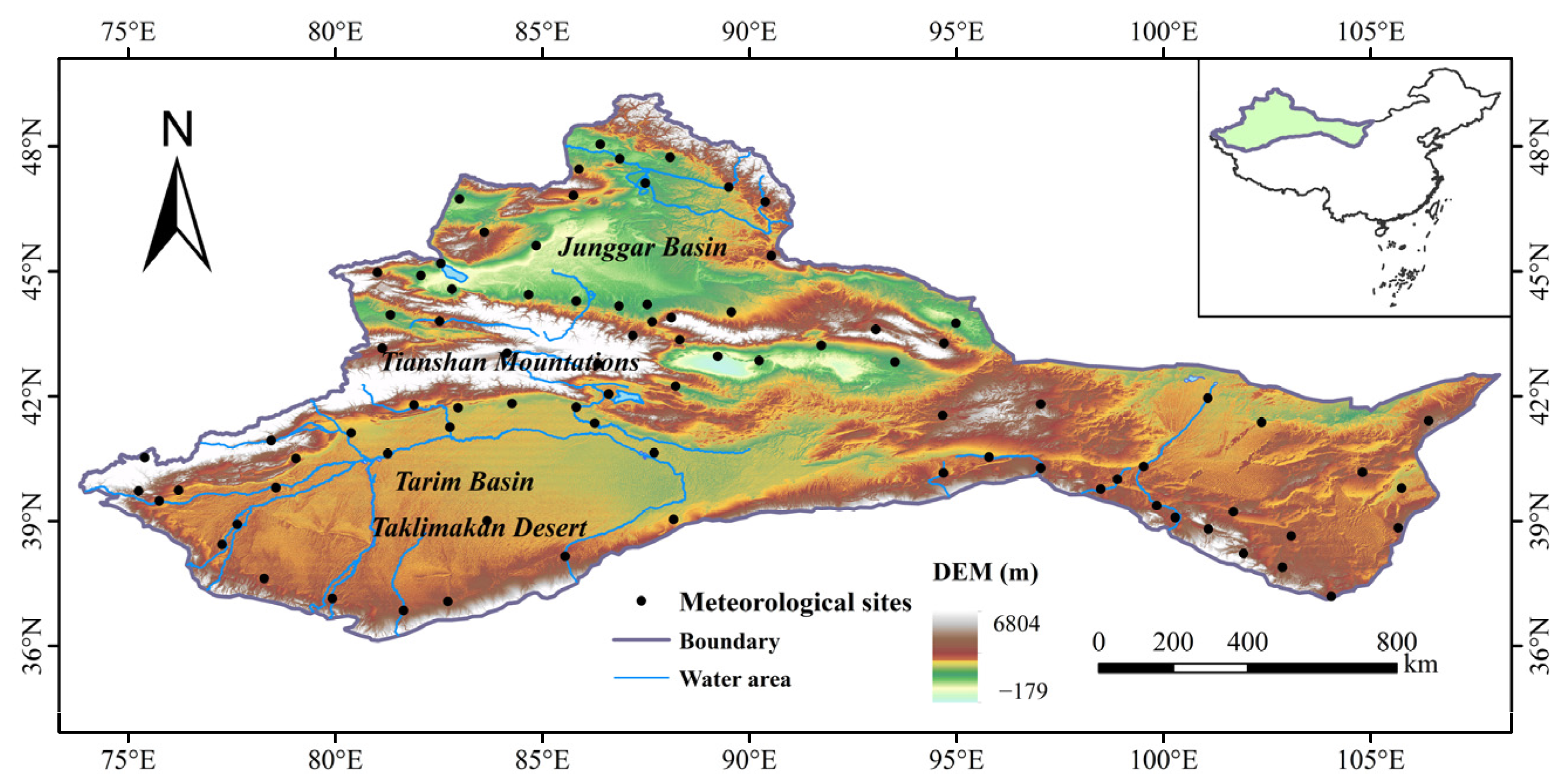
2.1. Study Area

The scope of NWC in this study refers to the NWC desert region within the seven natural regions of China’s comprehensive natural geographic zoning, considering the multi-year average precipitation, humidity, and temperature. The specific geographic location is 74.42–103.25°, north latitude 36.25–49.42°, encompassing roughly one-fifth of China’s total land area.
NWC is located deep in Eurasia, far from the ocean, and is mainly characterized by semi-arid and arid climates, which are further subdivided into temperate and warm-temperate climates, with scanty precipitation, high summer temperatures, and dry and cold winters. The multiannual mean temperature in the study area from 1961 to 2020 was 7.85 °C, within which the highest mean temperature was reached in 2007, at 9.10 °C. The mean temperature in NWC over the last 60a exhibits a rising pattern, with a tendency of rising 0.37 °C/10a. The mean precipitation in NWC is 287.57 mm, with summer precipitation accounting for 48.15% of the total. The precipitation exhibits a tendency to rise at a rate of 4.98 mm/10a, with high precipitation variability, extremely uneven spatial distribution, and high evaporation capacity, making it among the driest areas globally situated at a similar latitude. The climate of NWC is primarily controlled by westerly circulation, with year-round water vapor being transported mainly by the mid-latitude westerly belt. In addition, the summer months are influenced by the southeast monsoon, the local recirculation of water vapor, and the southwest monsoon.
The allocation of water resources exhibits significant imbalance, as most of the land is within the endorheic zone. An increase in population density has occurred in the endorheic river and lake areas, where oasis agriculture has developed. Being the driest region at a similar latitude globally, NWC is a typical ecologically fragile and climate-change-sensitive area. The impact of climate change on NWC is mainly characterized by changes in warming and precipitation patterns, which not only affect the water cycle process in the region but also precipitate surges in both the recurrence and the severity of extreme meteorological occurrences, including droughts and floods. Thus, NWC, which is highly dependent on climatic conditions and water resources, faces more severe challenges in terms of ecosystem stability, economic and industrial development, and the survival of tangible cultural heritage sites.

2.2. Data

2.2.1. Measured Data

Ground-based observations of precipitation and temperature at 86 national meteorological stations were used to determine the CEEs. The China Meteorological Administration (CMA) provided daily precipitation and air temperature data spanning the years 1961 to 2020. Although ground-based observations are susceptible to inaccuracies and indeterminacies, all datasets underwent rigorous quality assurance and consistency evaluation according to the standard protocols of the CMA [17]. Figure 1 illustrates the geographic distribution of meteorological stations.

2.2.2. CMIP6 Data

The observational data are employed to evaluate the historical products of CMIP6 models based on several statistical methods such as model bias and pattern correlation coefficient (PCC). The daily air temperature data was chosen for analysis, using the period from 1961 to 2015; this was employed to simulate monthly mean air temperature. To quantify the differences among models, we further calculated the PCC and normalized root-mean-square error (NRMSE) of each model, as compared with observations (Figure S1). Both PCC and NRMSE need to be considered when choosing high-performance models. The best 11 models with high PCC (greater than 0.5) and low NRMSE (smaller than the mean) were selected (upper left quadrant in Figure S1). The MME (multi-model ensemble) of the best 11 models (‘Best 11 MME’) is better than most of the other models in capturing the observed pattern.
Daily variations in near-surface maximum temperature (tasmax) and precipitation (pr) were analyzed using 11 CMIP6 models (Table 1). Based on the anomalies in the daily precipitation and near-surface maximum temperature, extreme events were identified using thresholds of 25% and 75%, respectively. Experimental data from four scenarios were selected for this study and the timescales were standardized to 2021–2100. To ensure consistency, most CMIP6 climate simulations at lower resolutions were remapped onto a standard 0.1° × 0.1° grid using bilinear interpolation [18]. To enhance accuracy, the MME was derived through the averaging of outcomes from each model. The MME mitigates the constraints inherent to a solitary model and has been shown to exhibit superior precision relative to a singular model, as evidenced by previous studies [19].

2.3. Definition of Compound Extreme Temperature and Extreme Precipitation Events

The delineation and computational approaches for CEEs in this study followed the methodology set forth by Beniston et al. [20] and Hao et al. [21]. In this research, the 25th and 75th percentile quantiles of precipitation and temperature over 30 years at a standard climate calculation time were employed as the threshold criteria for delineating the conjoined extremes. The calculations of the 25th/75th percentiles excluded the value of zero. Compound hot extremes and heavy precipitation (HE-HP) events, characterized by daily maximum temperatures exceeding the 75th percentile and daily precipitation higher than the 75th percentile, were delineated in this study. Compound heat extremity and dry (HE-D) events are characterized by daily maximum temperatures exceeding the 75th percentile and a lack of rainfall for a continuous seven-day period. In this study, ‘extreme’ refers to a moderate deviation from the mean that exceeds the 75th percentile or falls below the 25th percentile.

3. Results

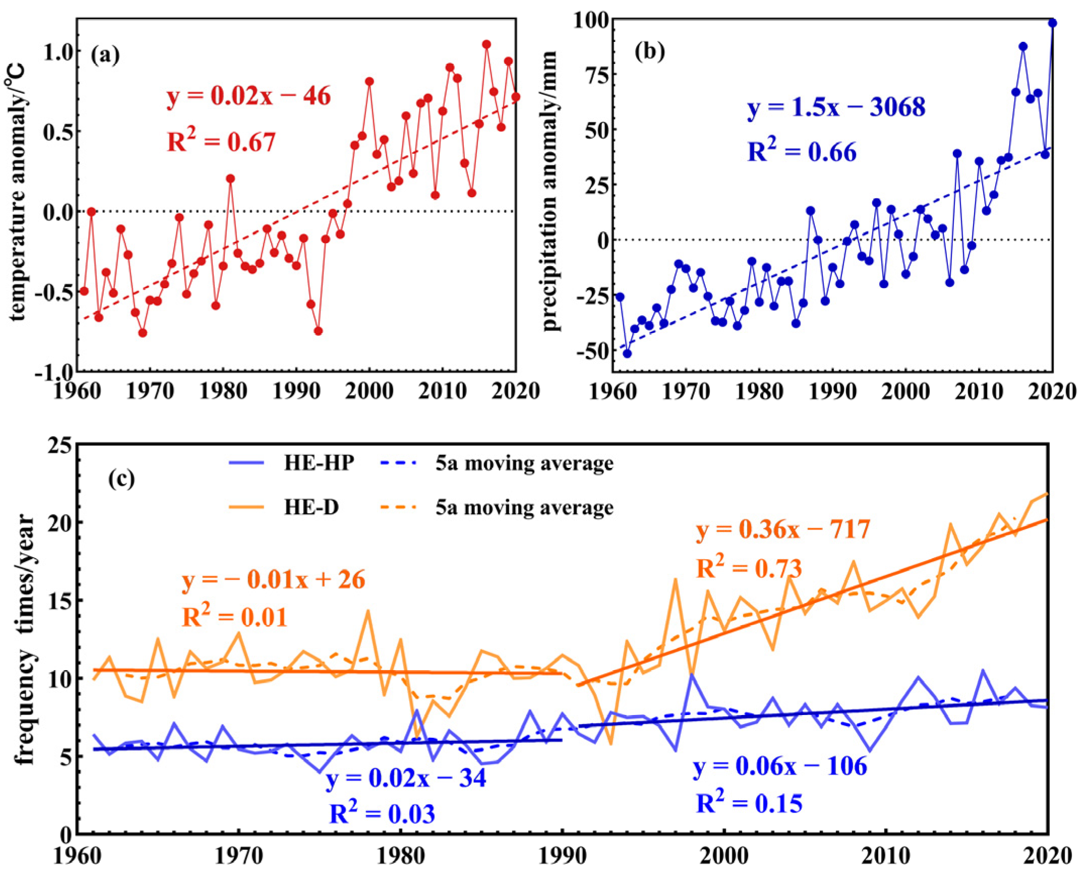
3.1. Observed Changes in CEEs

3.1.1. Annual Variations in Compound Events

The annual frequency and changing trends of CEEs at each weather station in NWC over the past 60 years were analyzed based on in situ datasets. As shown in Figure 2c, both the HE-D and HE-HP events showed a significant trend of increase from 1961 to 2020. The average annual HE-D events increased by 1.6/10a, whereas the average annual HE-HP events increased by 0.60/10a. Notably, the average annual HE-D events increased significantly more than the HE-HP events. The average annual HE-D events were considerably more frequent than HE-HP events, with annual HE-HP events occurring on average 5–10 times and annual HE-D events occurring on average 10–20 times.
Between 1961 and 2020, the year with the most HE-D events in NWC was 2020. According to the 2020 China Climate Bulletin, the summer temperature in 2020 showed a 0.5 °C positive anomaly based on the average summer temperature from 1961 to 2020. During this season, several regions experienced multiple high-temperature heat waves and prolonged periods of extreme heat. The number of days with high temperatures exceeded the multi-year average by 1.7 days. In northwestern Inner Mongolia and southern and eastern Xinjiang, high-temperature days amounted to 20–30 days, with eastern Xinjiang surpassing 30 days. The year 2020 was a dry year, with the precipitation in NWC less than 20–50% of the annual average [22]. Positive summer temperature anomalies contribute to increased evapotranspiration, which leads to moisture deficits. Furthermore, when the annual precipitation is significantly lower than the multi-year average, these factors collectively result in a substantially higher probability of drought in NWC. Additionally, the frequent occurrence of high-temperature heat waves significantly increases the probability of HE-D events. The aforementioned factors may account for the high frequency of HE-D events observed in the NWC during 2020.

3.1.2. Spatial Distribution of Compound Events

As shown in Figure 3, the probability of HE-HP events at almost all stations was lower than that in NWC, except for several stations located in the Tian Shan Mountains. The HE-HP events at most stations have an average annual frequency of 5–10 and only the stations located in the western Central and Southern Tienshan Mountains and western Junggar Basin had more than 15 HE-HP events on average annually. However, most stations located on the southern margin of the Tarim Basin had a lower HE-HP frequency, of <5 (Figure 3a). Almost all stations had more than 10 HE-D events, the number was especially high in eastern NWC and the southern margin of the Taklamakan Desert, with more than 20 events (Figure 3b).
On the spatial scale, different stations exhibited different patterns of change. However, HE-HP and HE-D events showed trends of increase at almost all stations from 1961 to 2020. For HE-HP events, only five stations, located in eastern NWC and the central Tarim Basin, showed a trend to decrease. Although HE-HP events at the other stations exhibited a rising pattern, the increases at most sites were not significant (approximately 1/10a). As for HE-HP events, only several stations located in western NWC showed a significant trend of increase (>2/10a). The greatest rates of increase were observed at the Animal Husbandry Meteorological Experiment Station of Urumqi and the Turgart station, which are located in the central Tian Shan Mountains and Pamir, respectively (Figure 3a). For HE-D events (Figure 3b), all stations exhibited a rising pattern, except for six stations in western NWC; however, the rising trend was not significant in the surrounding regions of the Taklamakan Desert (<1/10a). Additionally, the rising trend of HE-D events in eastern NWC (almost all stations > 2/10a) was greater than that found in western NWC (almost all stations < 2/10a).

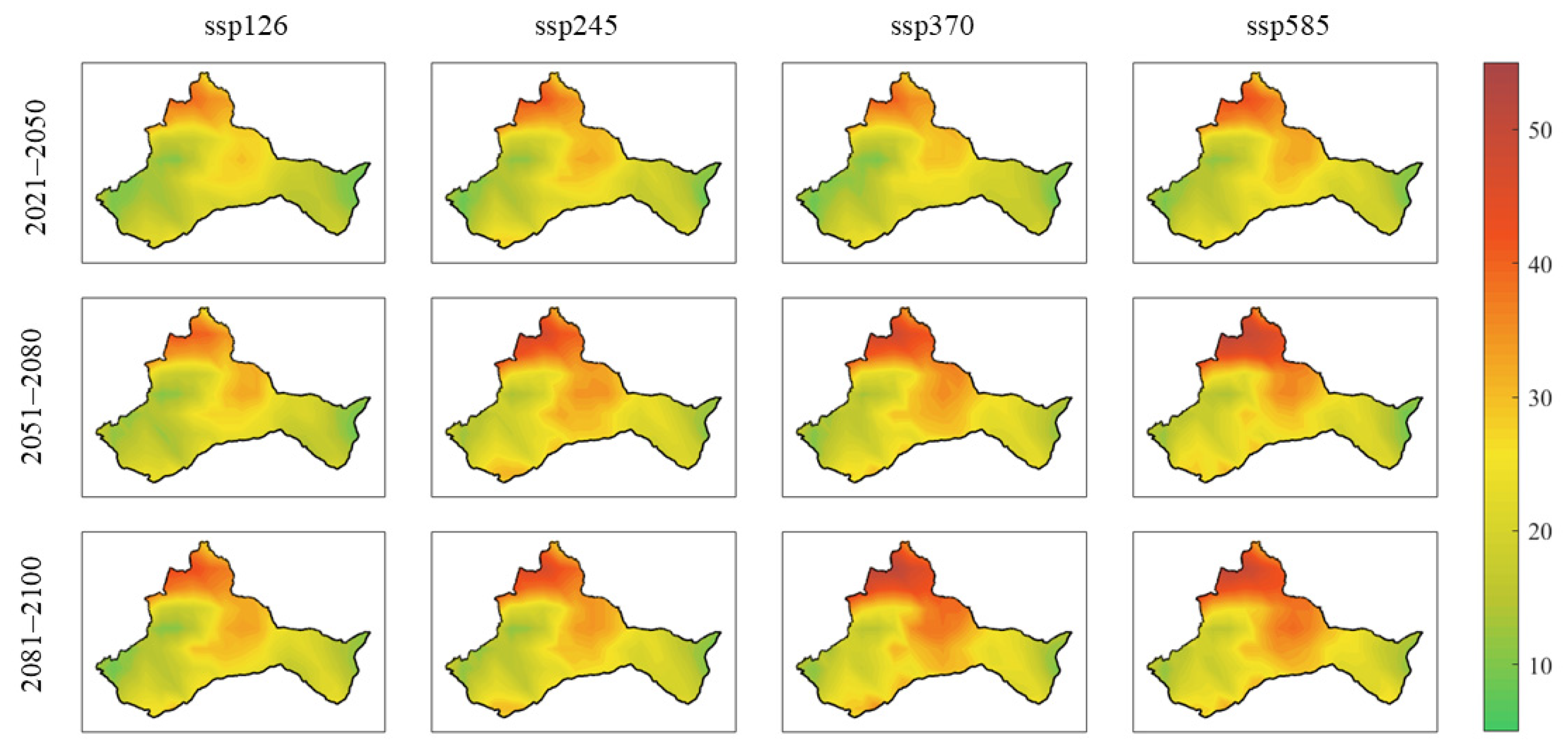
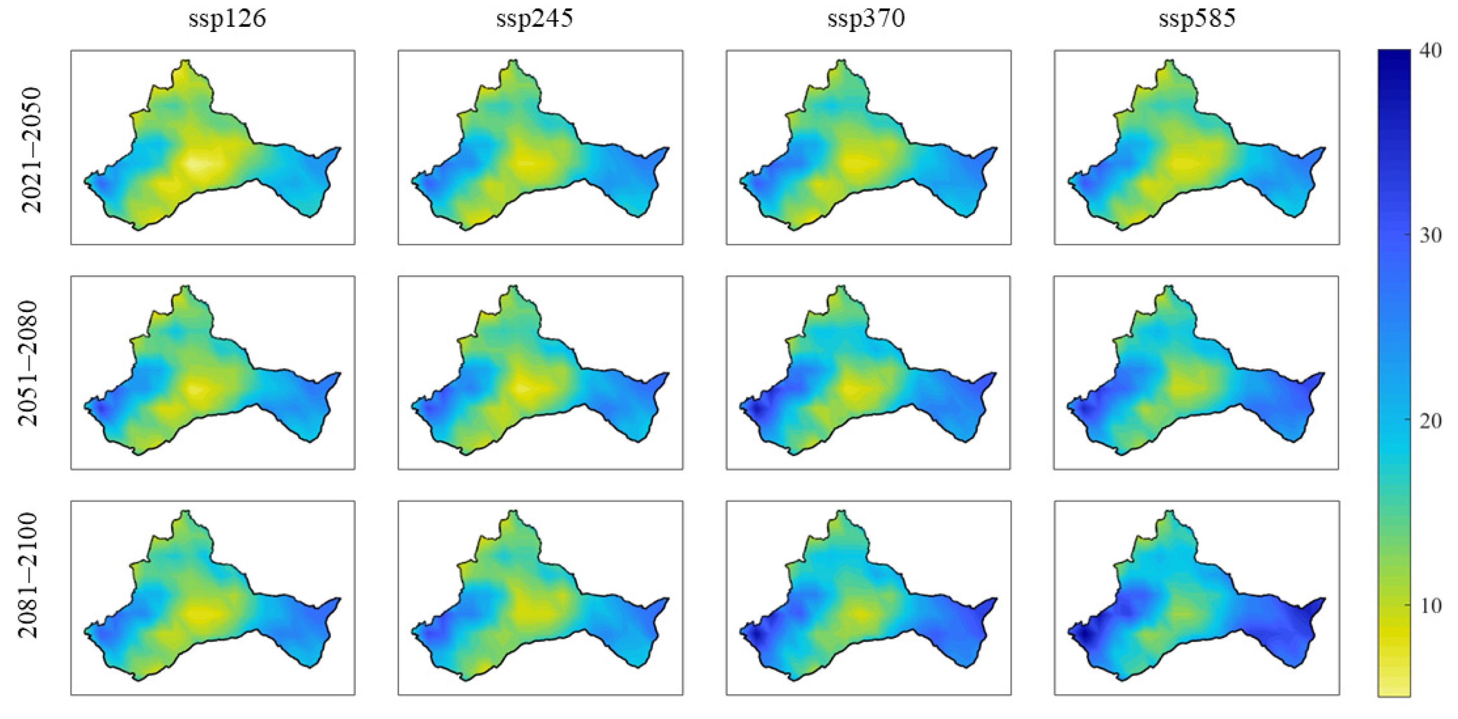
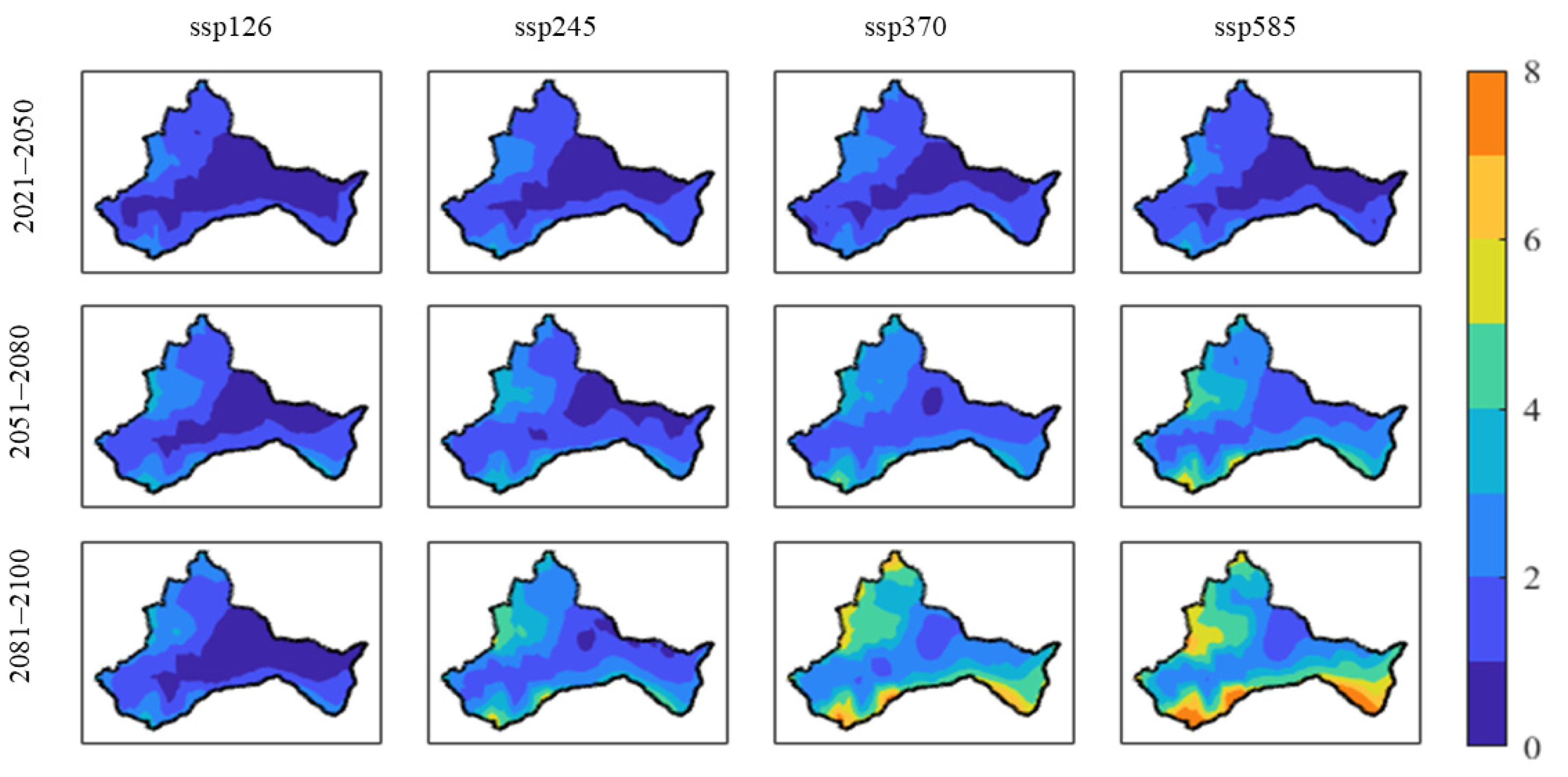
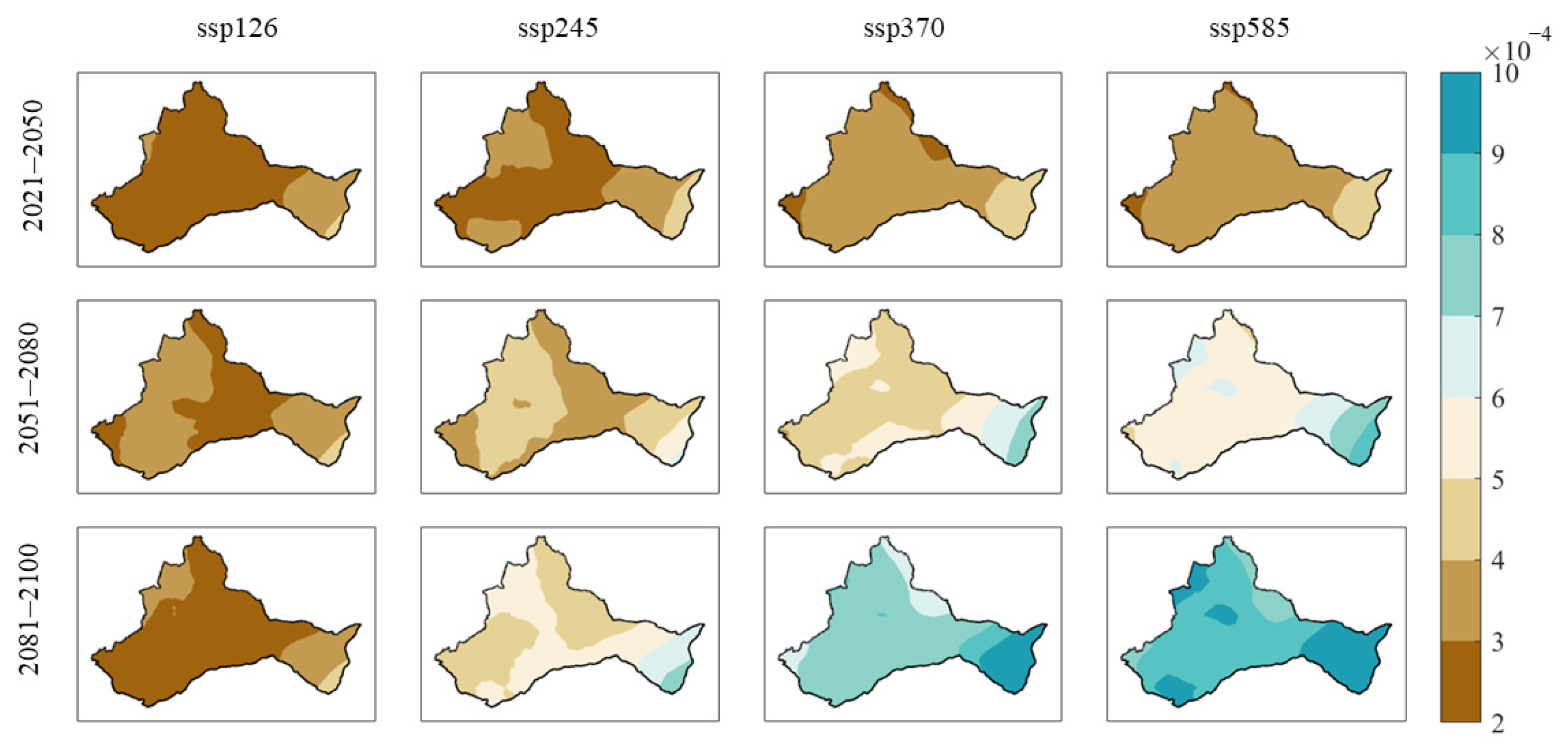
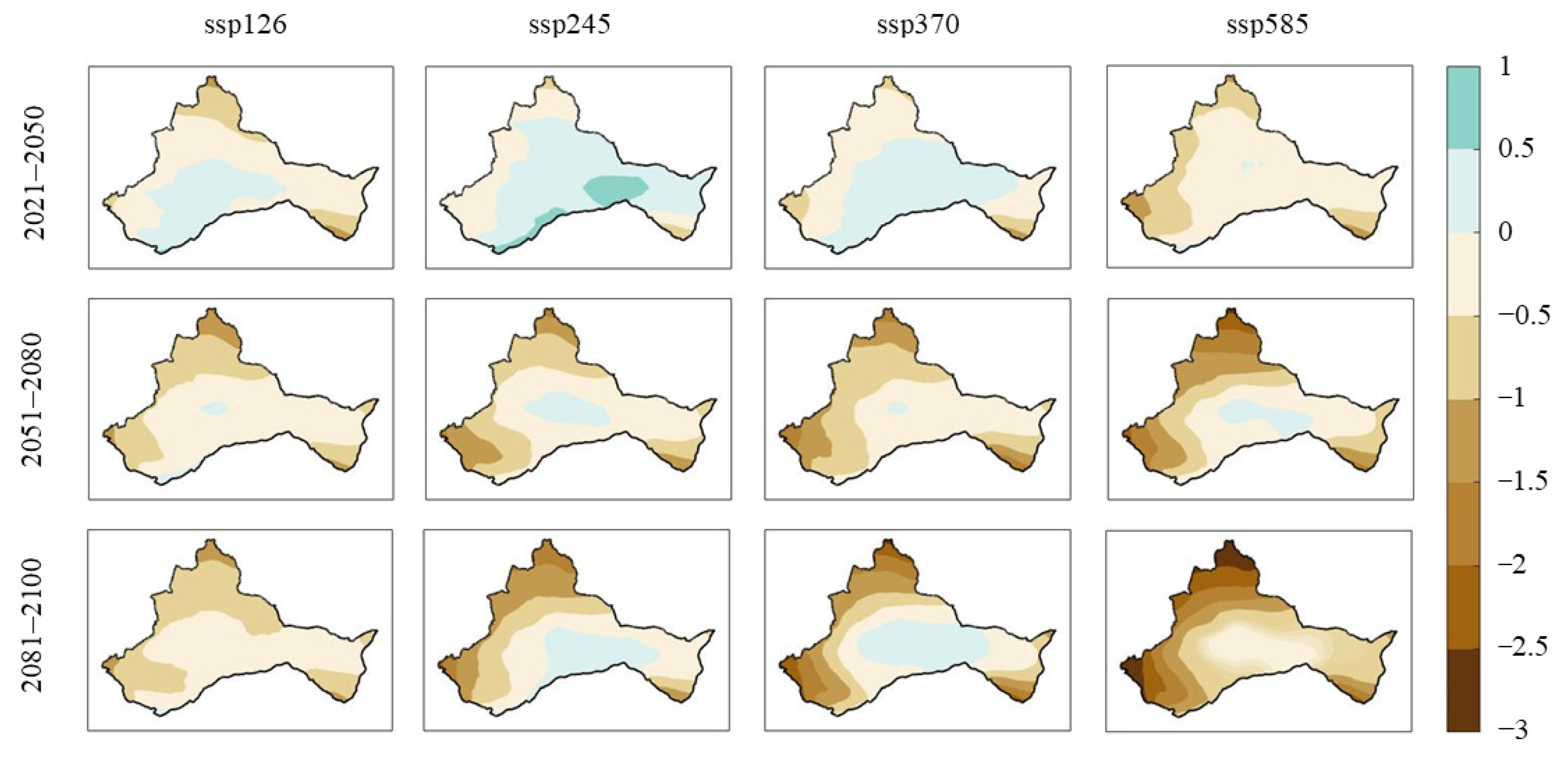
3.2. Projections of Compound Weather Extreme Events

3.2.1. Annual Variations in Compound Events

Under the SSP126, SSP245, SSP370, and SSP585 scenarios, the average annual frequency of HE-D events showed a trend to increase between 2020 and 2100 (Figure 4a), which is consistent with the findings of the observational data in the previous section. Under SSP126, the mean annual frequency of HE-D events decreased, whereas under SSP245, SSP370, and SSP585, the mean annual frequency of HE-D events increased. Under SSP126, the average annual frequency of HE-D events increased by 0.60/10a from 2015 to 2100, compared to 0.70/10a under SSP245, 1.50/10a under SSP370, and 1.70/10a under SSP585.
Under the four scenarios, there was a trend of increase in the yearly mean occurrence rate of HE-HP events between 2015 and 2100 (Figure 4b). This agrees with the observational data presented in the previous section. The trend in the mean annual frequency of HE-HP events was smaller under SSP126 and SSP245 than under SSP370 and SSP585. Under SSP126, the average annual growth rate of the average annual frequency of HE-HP events between 2015 and 2100 was 0.22/10a, compared to 0.23/10a under SSP245, 0.50/10a under SSP370, and 1.00/10a under SSP585.

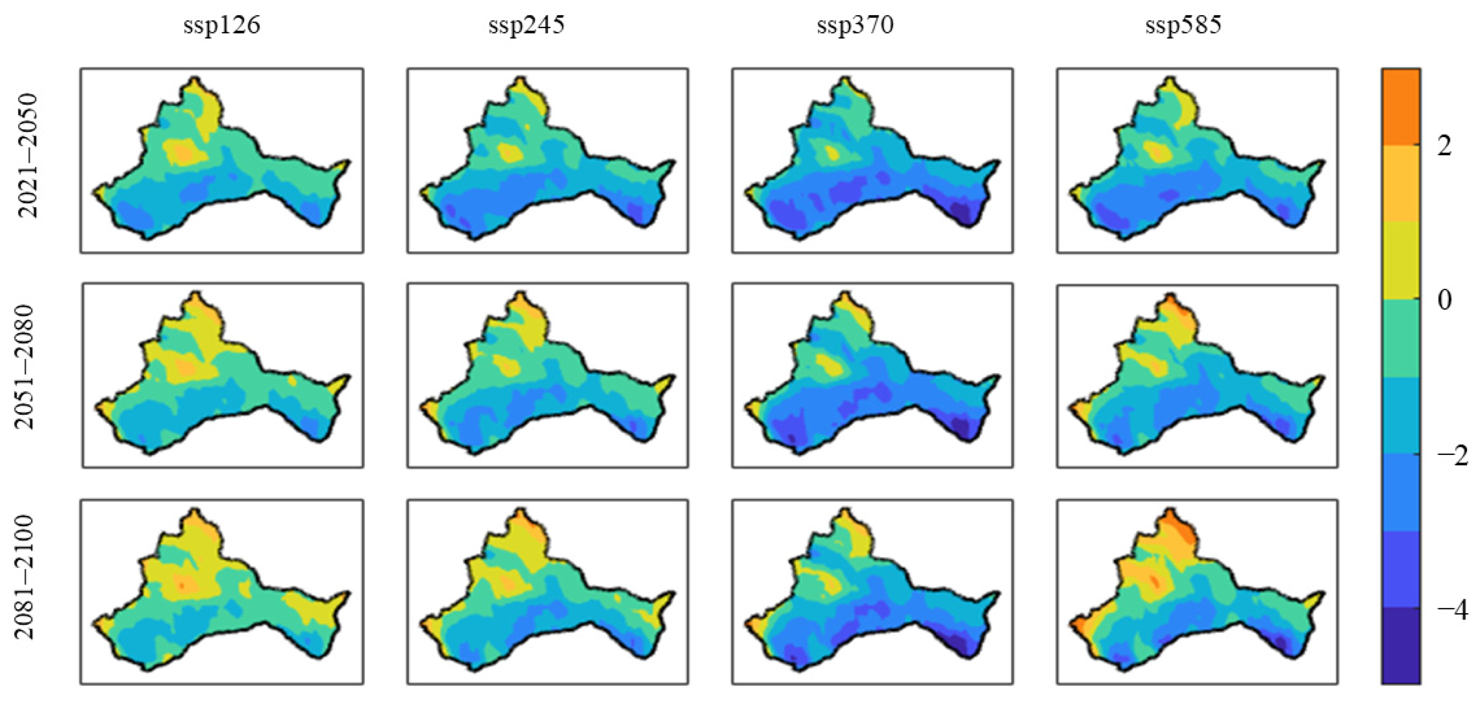
3.2.2. Spatial Distribution of Compound Events

The study analyzed the spatial distribution characteristics of future CEEs in NWC using three time frames: near future (2021–2050), mid-future (2051–2080), and far future (2081–2100).
In terms of spatial distribution, HE-D events were more distributed in the northern NWC (Figure 5). A gradual increase in CEEs occurred in the central NWC from 2021 to 2100.
The CMIP6 data exhibited a visible rise in the occurrence of HE-D events from 2051 to 2080, compared with from 2021 to 2050, under SSP126, SSP245, SSP370, and SSP585. However, there is no significant increase in the frequency of HE-D events between 2081 and 2100 compared to 2051–2080, indicating a steady state under the SSP126 and SSP245 scenarios. Under SSP370 and SSP585, there was a small increase in the frequency of HE-D events from 2081 to 2100 compared to from 2051 to 2080. This finding concurs with previous research indicating that episodes of extreme heat and heavy precipitation have grown more frequent since the year 1950 [23].
The frequency of HE-D events has an insignificant change between 2021 and 2050 under four scenarios, and there is only a small increase observed from SSP126 to SSP245 and from SSP370 to SSP585. From 2051 to 2080, and 2081 to 2100, there was a more pronounced increase in the recurrence of HE-D events when comparing SSP126 to SSP245 and SSP370 to SSP585.
In terms of spatial distribution, HE-HP events were more prevalent in the eastern and western areas of NWC (Figure 6). The CMIP6 data indicate that there will be a modest increase in HE-HP events from 2021 to 2100 under SSP126 and SSP245, but a significant increase in HE-HP events under SSP370 and SSP585.
From 2021 to 2050, the frequency of HE-HP events increased more significantly under SSP245 than under SSP126. However, the frequency of HE-HP events tended to be steady under SSP245, SSP370, and SSP585. From 2051 to 2080, the frequency of HE-HP events became more stable under SSP126 and SSP245, as it was under SSP370 and SSP585 and the rise in the recurrence of HE-HP events was more pronounced under SSP370 and SSP585 than under SSP126 and SSP245. Across SSP126, SSP245, SSP370 and SSP585, the average annual frequency of HE-HP events increases more significantly throughout NWC between 2081 and 2100, with the most notable rises in the east and west. HE-HP events spread from east and west to the center.
The frequency of HE-HP events may be increased in the periods 2021–2050 and 2051–2080 under the SSP126 and SSP370 scenarios. Under SSP245, the frequency of HE-HP events remains steady. After 2050, the frequency of HE-HP events under SSP126 and SSP370 will stabilize. This finding aligns with the outcomes documented by Sun et al. [24]. Under SSP585, the frequency of HE-HP events continues to increase with time.

4. Discussion

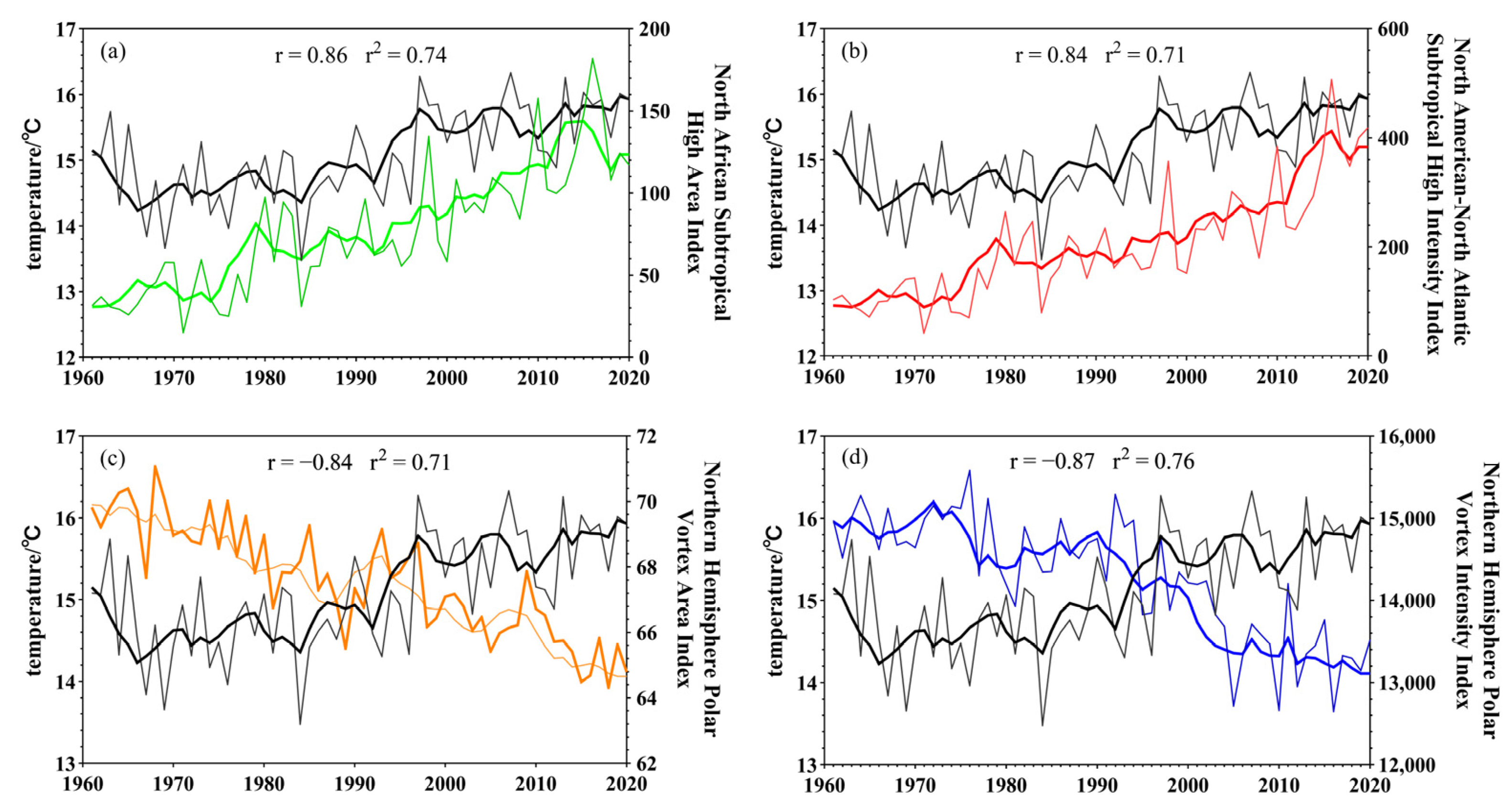
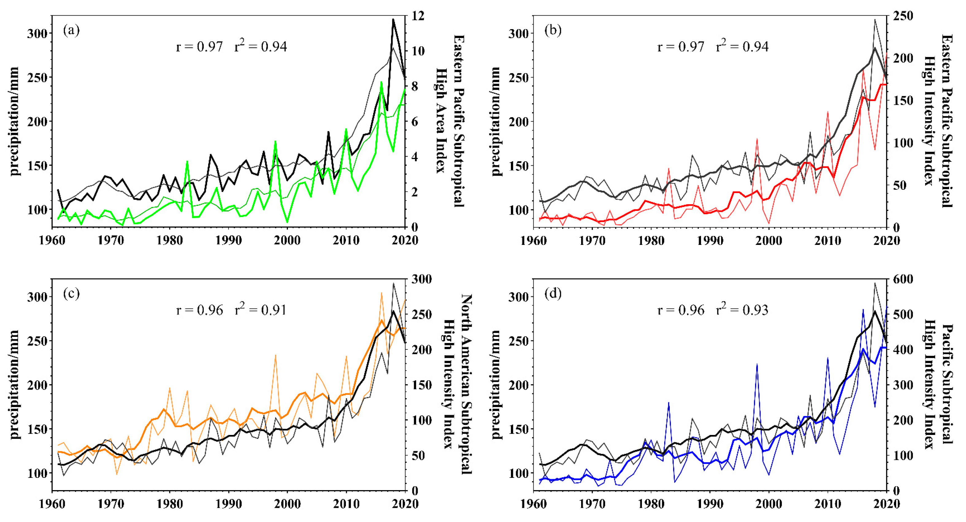
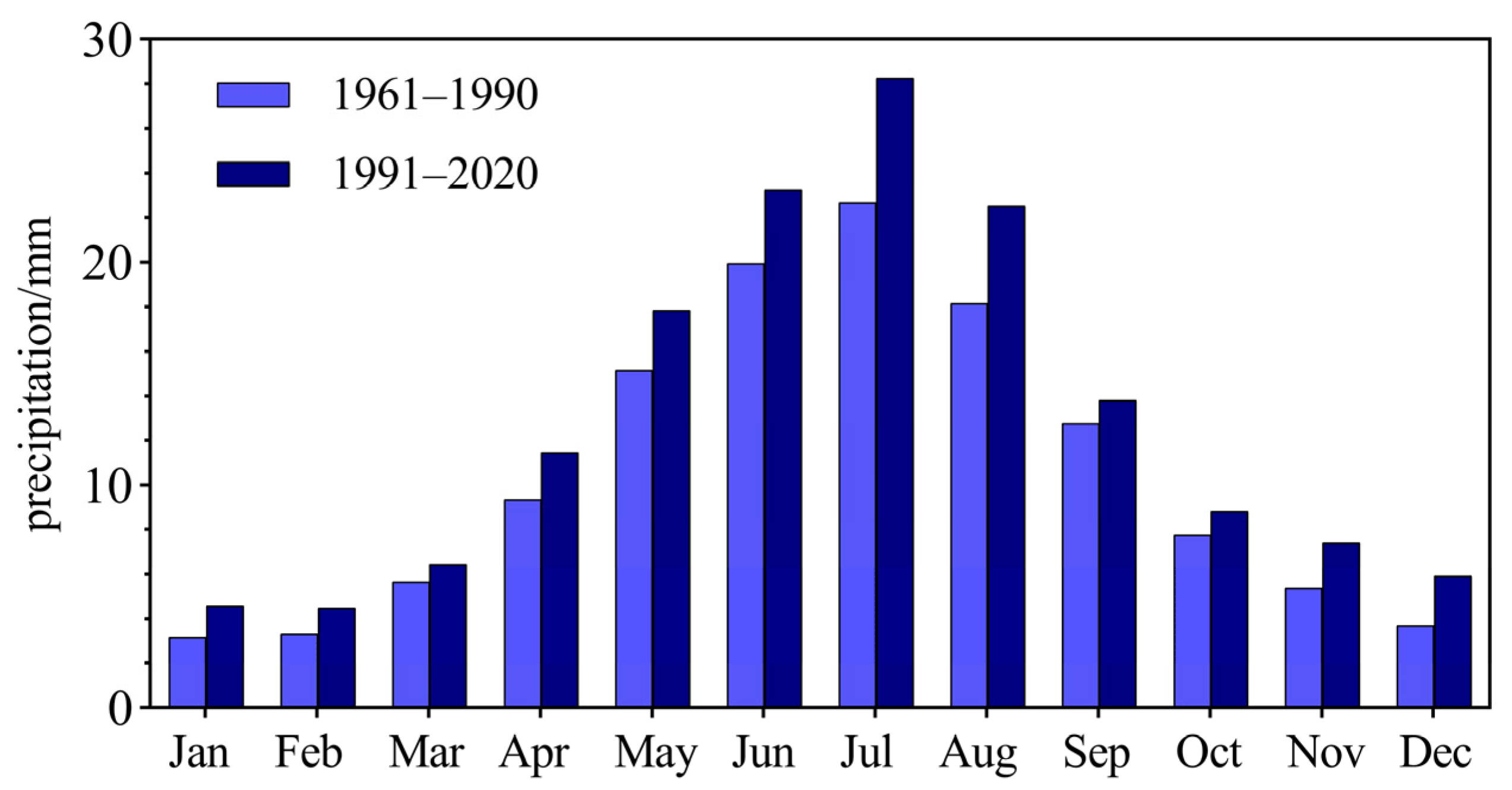
4.1. Influence Factor for the Warmer and Wetter Trend in the NWC

Several studies have confirmed that global warming plays a crucial role in the generation and development of extreme events and CEEs [9,25,26]. It is generally acknowledged that high levels of greenhouse gas emissions are a vital cause of global warming, which is also the case in NWC [27]. In addition, the temperatures in NWC have been influenced by atmospheric circulation anomalies. The intensity, weakness, and fluctuations of the subtropical high-pressure system restrain the mid-latitude climate. The placement and strength of the subtropical high-pressure system can affect precipitation patterns, whereas the intensity of the polar vortex is related to global temperature changes. For example, extreme temperature changes in NWC are closely related to the Arctic Oscillation [28], which can cause unusual easterly winds [29], and the Pacific Decadal Oscillation has an important implication for humidity in NWC [30]. The emergence of EI Niño results in deviations in global climate, serving as a significant driver behind droughts and floods in China [30]. Accordingly, the present research effort computed correlations to examine the implications of each circulation factor for temperature and precipitation patterns. Second, the various factors affecting CEEs have only been qualitatively analyzed; a quantitative assessment of the magnitude of influence which each determinant exerts on the recurrence of such events is lacking, particularly as to the influence of human activities (Table S1).
Table 2 shows a notable difference in the correlations between the circulation factors and the maximum temperature. The correlations of the NAS and the NH with the maximum temperature were greater than that with NANA and NHA. The maximum temperatures exhibited the strongest response to NH influences, which was followed by NAS, and finally NANA and NHA. The associated series plots in Figure 7c,d exhibit a robust negative correlation between the NH/ NHA and the maximum temperature in NWC. The correlation coefficient between the NH and the maximum temperature in NWC was −0.87 and that between the NHA and the maximum temperature in NWC was −0.84, both passing the 99% confidence test. The associated series plots in Figure 7a,b exhibit a robust positive correlations of the NAS and NANA with the maximum temperature in NWC. The correlation coefficient between the NAS and the maximum temperature in NWC was 0.86 and that between the NANA and the maximum temperature in NWC was 0.84, both passing the 99% confidence test. In NWC, the maximum temperatures show a trend to decrease with an increase in NH/NHA and a trend to increase with an increase in NAS/NANA.
Table 2 shows significant differences in the correlations between circulation factors and precipitation. The correlations of ESA and ES with precipitation were found to be stronger than those with NAM and PS. The corresponding series plots in Figure 8 show strong positive correlations of ESA (Figure 8a), ES (Figure 8b), NAM (Figure 8c), and PS (Figure 8d) with precipitation in the NWC; precipitation shows the strongest response to the ESA and ES influences, followed by the NAM and PS influences, at 0.97, 0.97, 0.96, and 0.96, all passing the 99% confidence test. In NWC, precipitation exhibits an increasing pattern with rising ESA/ES/NAM/PS values.

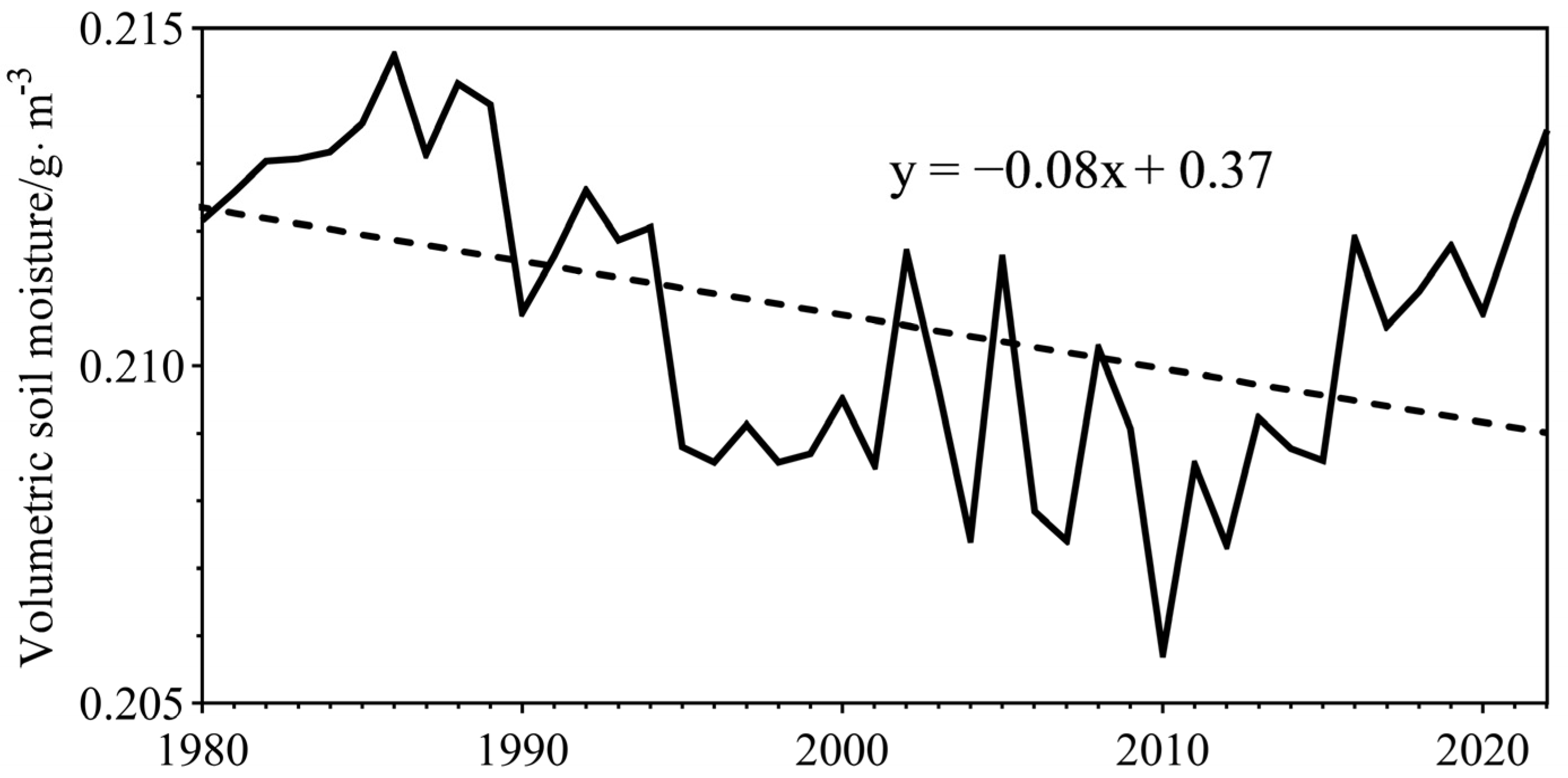
4.2. Driving Mechanism for HE-D Events

Under global warming, the probability of HE-D events in NWC has substantially increased because of the influence of atmospheric circulation anomalies and land–air coupling processes [31]. Byrne et al. [32] confirmed the mechanism of “the drier the hotter”, and the decreased soil water content leads to the increased probability of warming. Increased temperatures and net radiation accelerate soil evaporation and plant transpiration. This reduces soil water content, which, in turn, inhibits soil evaporation and plant evapotranspiration. Soil moisture decreased significantly from 1980 to 2010 and has increased since 2010 due to increased precipitation and irrigation (Figure 2b and Figure 9) [33,34]. Increased soil–air latent heat interactions lead to decreased soil moisture. However, decreased soil moisture leads to increased soil–air sensible-heat interactions. In Figure 5 and Figure 10, regardless of the scenario, the trend of the latent heat change is similar to that of the HE-D event change. In regions where HE-D events are increasing, latent heat is also increasing, especially in the northern region of NWC. The region of change for latent heat is distinct from that of the HE-HP events, whereas the trend of sensible-heat change mirrors that of the HE-HP events. Latent heat exhibits a clear upward trend in the eastern and western regions of the NWC, whereas the upward trend is less pronounced in the central and northern regions of the NWC. (Figure 11). Therefore, the soil–atmosphere latent heat exchange increases, and this leads to a further decrease in soil moisture [35,36]. Moreover, increased soil–atmosphere sensible-heat exchange results in a warmer atmospheric environment and a thickened atmospheric boundary layer [37,38,39]. The water vapor pressure deficit in the atmospheric boundary layer increases, which leads to a further soil moisture deficit [40]. This procedure continues until the evening. The land–atmosphere interaction feedback mechanism under global warming serves as a significant driver of HE-D events in the NWC (Figure 12).

4.3. Driving Mechanism of HE-HP Events

Located at mid-to-high latitudes, NWC experiences atmospheric water vapor transport that is impacted by both the circulation of westerly winds and the southwest monsoon circulation, as described by [41]. The water vapor transport within the westerly wind belt furnishes the fundamental source of moisture for the majority of NWC; alterations in the westerly winds directly influence the interannual variability of water vapor transport, and high-altitude jets shift northward and eastward [42], which has shown a trend of increase in recent years.
Multiple studies have confirmed trends of increasing temperature and precipitation in NWC; however, further research indicates that the warmer trend is more pronounced than the wetter trend. In other words, the increased temperature was more significant than the increased precipitation, which was confirmed by the changing trends of specific humidity and relative humidity in the future (as shown in Figure 13 and Figure 14). According to Figure 13, the specific humidity change trends in NWC show increases from 2021 to 2100 under all scenarios, showing a more pronounced rate of growth in the western and eastern regions of NWC compared to the central areas. However, according to Figure 14, the projection of the relative humidity change trends of SSP126–585 are generally indicative of decrease in NWC. However, different spatial patterns were observed in different scenarios. Under SSP126 and SSP370, the central region of NWC will exhibit a persistent trend of increasing specific humidity until approximately 2050. In contrast, other areas continue to experience a significant drying trend until 2100, particularly in the northern and western areas. Under SSP585, the central region exhibits an insignificant wetting trend, whereas the western and northern regions display pronounced drying trends. This drying trend does not contradict the rise in extreme precipitation. Although the relative humidity of the air decreases, the moisture content of the air increases. This leads to an increase in the vapor pressure deficit of air. In addition, an increase in the vapor pressure deficit of air leads to a situation in which water vapor is less likely to condense and precipitate. Moreover, the increased specific humidity and the rise in the vapor pressure deficit are unfavorable for the occurrence of light precipitation events [43,44,45].
Since the 1980s, the NWC climate has transitioned from warm and dry to warm and wet [46,47]. There is growing evidence that the interdecadal increase in westerly circulation and the longitudinal shift of subtropical westerly jets have resulted in increased transportation of water vapor, which likely explains the increased precipitation [48].
However, these studies merely illuminate the causative factors behind the rise in precipitation levels within NWC, without elucidating the underlying reasons for the escalation in instances of extreme precipitation. The observational data shows that, compared with the average from 1961 to 1990, the precipitation in NWC generally showed a trend of increase, especially in July, August, and September, contributing approximately 47.71% of the total precipitation increment (Figure 15). In addition, current research findings indicate that the quantity of precipitation days and instances of light precipitation in NWC exhibit trends of decrease [49,50,51]. The increase in the vapor pressure deficit, which results in water vapor that is less likely to condense, may be one of the reasons for this (Figure 13 and Figure 14). Furthermore, the significant negative phase of the Silk Road teleconnection wave train induces a longitudinal displacement of the Asian jet stream. Consequently, this has led to an interdecadal anomaly of summer precipitation in the eastern part of NWC since 1998 [52]. Figure 16 presents the anomaly maps of the 500 hpa atmospheric circulation patterns between 1991 and 2020, and 1961 and 1990. Wind anomalies in the low troposphere exhibited significant cyclonic circulation on both sides of NWC. The anomalous cyclone on the eastern side facilitated the transport of water vapor from the western North Pacific to NWC. Meanwhile, the instability between the Mongolian High and Siberian Low induces anomalous cyclones over NWC, promoting the anomalous intensification of westerly and easterly airflows and leading to the generation of extreme precipitation [53]. As a consequence, there was a significant rise in the recurrence of HE-HP events (Figure 12).

4.4. Limitations and Outlooks

First, the definitions based on the 25th/75th percentile threshold were slightly subjective. The relative threshold method is a widely used approach that employs a specified extreme index and 90th/95th percentile for individual extreme occurrences [54]. Nevertheless, there is disagreement concerning the determination of thresholds for composite events, with some scholars retaining the 90th/95th percentile from an individual extreme index [55,56] and others opting for the 25th/75th percentile [31]. Nevertheless, Hao et al. [21] discovered that combined precipitation–temperature statistical metrics exhibit relative insensitivity to the selection of quantile thresholds. Their research revealed consistent trends in extreme events, even with an alternative 10th/90th percentile threshold. Although different threshold combinations yielded essentially the same trends in the results, the degree of detail varied [57]. An important future direction for CEEs is to find a way to define them accurately. There is also a need to strengthen research on the linkages between extreme events to assess future trends in the regularity and attributes of extreme compound events [10].
Secondly, while the multitude of elements impacting compound extreme occurrences have undergone qualitative examination, there lacks a quantitative assessment of the magnitude of influence that each determinant exerts on the recurrence of such events, notably the impact of anthropogenic actions. Human activities are a significant driver of climate change. Determining the precise impact of anthropogenic activities on regional climate change is a priority for future research [58,59].
Third, the results have large uncertainties in the study area because of the complex terrain and climatic conditions, sparse and non-uniform distribution of meteorological stations, poor representativeness, and poor resolution of the model. In addition, inter-model uncertainties remain high in precipitation and temperature projections [60,61]. CMIP6 Models can overestimate annual precipitation in drylands by approximately 33%, compared with observations [62]. CMIP6 projections overestimate warming in China [63]. This leads to uncertainty in the projection of compound temperature and precipitation events.
Fourth, water scarcity is a primary factor contributing to the vulnerability of the arid ecosystem. The CEEs have resulted in an increasingly imbalanced distribution of water resources under climate change, which has had profound impacts on arid ecosystems [64,65,66]. In the future, as the frequency of CEEs continues to rise, their impacts are expected to become even more pronounced. Additionally, the limited recovery capacity is a key characteristic of the arid ecosystem, and it is difficult to regain its prior state once damaged. Therefore, enhancing the accuracy of CEE prediction and, specifically, their likely effects on arid ecosystems, based on new technologies and methodologies, may represent a promising research field in the future.
Ultimately, these aspects pose certain challenges for disaster prediction over the next 30–50 years. Future studies should focus on a mechanistic study of climate warming and wetting in the NWC, quantitatively analyze the impacts of various influencing factors, and develop appropriate risk response strategies. In addition, by establishing more meteorological stations, refining observation methodologies, and harnessing sophisticated modeling approaches, the precision of future forecasts for complex extreme weather phenomena can be increased.

5. Conclusions

We used different threshold combinations to construct two distinct sets of event networks in the northwest region. The principal findings are summarized as follows.
Over the past 60 years, the frequency of CEEs in NWC has increased. Nevertheless, the linear trend of HE-D events is larger than that of HE-HP events, reaching 1.60 times/decade, while the HE-HP events occur at the rate of 0.60 times/decade. The CEEs in NWC varied abruptly around 1990, which aligns fundamentally with the hypothesis that the climate of NWC underwent a transformation commencing from 1987. Spatial differences between HE-D and HE-HP events in NWC have been prominent, particularly in eastern NWC, specifically as to the sites of stations recording the peak and nadir frequency levels of HE-D and HE-HP events. However, CEEs exhibited a rising tendency across nearly all stations. A pronounced trend of increase in CEEs was observed from 2021 to 2100. The linear trend of SSP585 was the largest, reaching 1.70 times/10a (HE-D events) and 1.00 times/10a (HE-HP events), followed by SSP370. SSP126 and SSP245 did not show a significant linear trend. From 2020 to 2100, the spatial distribution of HE-D events showed a trend of “higher in the north and lower in the south”. The space allocation pattern of HE-HP events showed “more in the east and west, less in the middle”.
Warming increases soil evaporation and plant transpiration, resulting in decreased soil moisture content. Simultaneously, soil moisture deficiency suppresses soil evaporation and plant transpiration, resulting in a reduction in latent heat and an augmentation in sensible heat, thereby enhancing the heating efficiency of the underlying surface relative to the atmosphere. Moreover, soil moisture evaporates quickly at higher temperatures. These feedback processes contribute to the sustained intensification of HE-D events. The rise in temperature in NWC led to an augmentation in evapotranspiration, leading to a reduction in soil moisture content and a reduction in atmospheric-soil latent heat exchange. This soil warming contributes to the frequent occurrence of HE-D events. Anomalies in atmospheric circulation and the land–atmosphere feedback mechanism under the background of climate warming are significant drivers of HE-D events in NWC.
Commencing in the 1980s, the climate of NWC has undergone a transformation from a warm and dry state to a warm and wet state. However, the warmer trend was stronger than the wetter trend. The warmer trend being greater than that of the wetter trend reduced the frequency of light rain events. Concurrently, the anomalous intensification of westerly and easterly winds has further concentrated the precipitation, leading to the generation of extreme precipitation, which triggers HE-HP events.

Supplementary Materials

The following supporting information can be downloaded at: https://www.mdpi.com/article/10.3390/rs16173111/s1, Table S1: Relationship between the temperature, precipitation and the Atmospheric Circulation Index. Table S2: Symbols and Abbreviations Used in the Manuscript. Figure S1: Performance of the 22 CMIP6 models and their MME (solid black dot) on simulating the observed monthly mean air temperature over the NWC during 1961–2015. The vertical and horizontal coordinates in Figure S1 are PCC and NRMSE, respectively. The horizontal gray line in Figure S1 indicates the PCC greater than 0.5. The vertical gray line in Figure S1 indicates the mean value of the NRMSE of 22 models. The hollow black square in Figure S1 depicts the MME of the se-lected best 11 models enclosed in the upper left quadrant.

Author Contributions

Conceptualization, W.S., R.C. and C.H.; methodology, H.N.; software, Y.W. (Yuzhe Wang); validation, L.W.; formal analysis, B.H.; investigation, J.Z.; resources, R.C. and W.S.; data curation, H.N.; writing—original draft preparation, H.N.; writing—review and editing, L.W. and B.H.; visualization, H.N.; supervision, Y.W. (Yuzhe Wang); project administration, Y.W. (Yingshan Wang); funding acquisition, L.W., B.H. and W.S. All authors have read and agreed to the published version of the manuscript.

Funding

The research was funded by the National Natural Sciences Foundation of China, Nos. 42101120, 42171121, and 42271145; the Support Plan on Science and Technology for Youth Innovation of Universities in Shandong Province, No. 2023KJ195; and the National Natural Science Foundation of Shandong Province, No. ZR2021QD138.

Data Availability Statement

The original contributions presented in the study are included in the article/Supplementary Material; further inquiries can be directed to the corresponding author/s.

Conflicts of Interest

The authors declare no conflicts of interest.

References

  1. IPCC. AR6 Climate Change 2021: The Physical Science Basis. 2021. Available online: https://www.ipcc.ch (accessed on 8 May 2024).
  2. Martius, O.; Pfahl, S.; Chevalier, C. A Global Quantification of Compound Precipitation and Wind Extremes. Geophys. Res. Lett. 2016, 43, 7709–7717. [Google Scholar] [CrossRef]
  3. Yu, R.; Zhai, P. Changes in Compound Drought and Hot Extreme Events in Summer over Populated Eastern China. Weather Clim. Extrem. 2020, 30, 100295. [Google Scholar] [CrossRef]
  4. Zscheischler, J.; Westra, S.; Van Den Hurk, B.J.J.M.; Seneviratne, S.I.; Ward, P.J.; Pitman, A.; AghaKouchak, A.; Bresch, D.N.; Leonard, M.; Wahl, T.; et al. Future Climate Risk from Compound Events. Nat. Clim. Chang. 2018, 8, 469–477. [Google Scholar] [CrossRef]
  5. Zscheischler, J.; Martius, O.; Westra, S.; Bevacqua, E.; Raymond, C.; Horton, R.M.; Van Den Hurk, B.; AghaKouchak, A.; Jézéquel, A.; Mahecha, M.D.; et al. A Typology of Compound Weather and Climate Events. Nat. Rev. Earth Environ. 2020, 1, 333–347. [Google Scholar] [CrossRef]
  6. Yu, R.; Zhai, P. Advances in scientific understanding on compound extreme events. Trans. Atmos. Sci. 2021, 44, 645–649. [Google Scholar] [CrossRef]
  7. Peng, T.; Zhao, L.; Zhang, L.; Shen, X.; Ding, Y.; Wang, J.; Li, Q.; Liu, Y.; Hu, Y.; Ling, J.; et al. Changes in Temperature-Precipitation Compound Extreme Events in China during the Past 119 Years. Earth Space Sci. 2023, 10, e2022EA002777. [Google Scholar] [CrossRef]
  8. Stott, P. How Climate Change Affects Extreme Weather Events. Science 2016, 352, 1517–1518. [Google Scholar] [CrossRef] [PubMed]
  9. Alizadeh, M.R.; Adamowski, J.; Nikoo, M.R.; AghaKouchak, A.; Dennison, P.; Sadegh, M. A Century of Observations Reveals Increasing Likelihood of Continental-Scale Compound Dry-Hot Extremes. Sci. Adv. 2020, 6, eaaz4571. [Google Scholar] [CrossRef] [PubMed]
  10. Bevacqua, E.; Zappa, G.; Lehner, F.; Zscheischler, J. Precipitation Trends Determine Future Occurrences of Compound Hot–Dry Events. Nat. Clim. Chang. 2022, 12, 350–355. [Google Scholar] [CrossRef]
  11. Allan, R.P.; Willett, K.M.; John, V.O.; Trent, T. Global Changes in Water Vapor 1979–2020. JGR Atmos. 2022, 127, e2022JD036728. [Google Scholar] [CrossRef]
  12. Ren, D.; Wang, Y.; Wang, G.; Liu, L. Rising Trends of Global Precipitable Water Vapor and Its Correlation with Flood Frequency. Geod. Geodyn. 2023, 14, 355–367. [Google Scholar] [CrossRef]
  13. Zhang, J.; Zhao, T.; Dai, A.; Zhang, W. Detection and Attribution of Atmospheric Precipitable Water Changes since the 1970s over China. Sci. Rep. 2019, 9, 17609. [Google Scholar] [CrossRef]
  14. Hoell, A.; Quan, X.-W.; Hoerling, M.; Diaz, H.F.; Fu, R.; He, C.; Lisonbee, J.R.; Mankin, J.S.; Seager, R.; Sheffield, A.; et al. Water Year 2021 Compound Precipitation and Temperature Extremes in California and Nevada. Bull. Am. Meteorol. Soc. 2022, 103, E2905–E2911. [Google Scholar] [CrossRef]
  15. Yin, J.; Gentine, P.; Slater, L.; Gu, L.; Pokhrel, Y.; Hanasaki, N.; Guo, S.; Xiong, L.; Schlenker, W. Future Socio-Ecosystem Productivity Threatened by Compound Drought–Heatwave Events. Nat. Sustain. 2023, 6, 259–272. [Google Scholar] [CrossRef]
  16. Zhang, Y.; Mao, G.; Chen, C.; Lu, Z.; Luo, Z.; Zhou, W. Population Exposure to Concurrent Daytime and Nighttime Heatwaves in Huai River Basin, China. Sustain. Cities Soc. 2020, 61, 102309. [Google Scholar] [CrossRef]
  17. Xing, Z.; Yu, Z.; Wei, J.; Zhang, X.; Ma, M.; Yi, P.; Ju, Q.; Wang, J.; Laux, P.; Kunstmann, H. Lagged Influence of ENSO Regimes on Droughts over the Poyang Lake Basin, China. Atmos. Res. 2022, 275, 106218. [Google Scholar] [CrossRef]
  18. Wang, X.; Li, Y.; Chen, Y.; Li, Y.; Wang, C.; Kaldybayev, A.; Gou, R.; Luo, M.; Duan, W. Intensification of Heatwaves in Central Asia from 1981 to 2020—Role of Soil Moisture Reduction. J. Hydrol. 2023, 627, 130395. [Google Scholar] [CrossRef]
  19. Ma, Z.; Sun, P.; Zhang, Q.; Zou, Y.; Lv, Y.; Li, H.; Chen, D. The Characteristics and Evaluation of Future Droughts across China through the CMIP6 Multi-Model Ensemble. Remote Sens. 2022, 14, 1097. [Google Scholar] [CrossRef]
  20. Beniston, M. Trends in Joint Quantiles of Temperature and Precipitation in Europe since 1901 and Projected for 2100: Joint heat and moisture extremes. Geophys. Res. Lett. 2009, 36, L07707. [Google Scholar] [CrossRef]
  21. Hao, Z.; AghaKouchak, A.; Phillips, T.J. Changes in Concurrent Monthly Precipitation and Temperature Extremes. Environ. Res. Lett. 2013, 8, 034014. [Google Scholar] [CrossRef]
  22. Ma, Q.; Li, Z.; Chen, Z.; Su, T.; Wu, Y.; Feng, G. Moisture Changes with Increasing Summer Precipitation in Qilian and Tienshan Mountainous Areas. Atmos. Sci. Lett. 2023, 24, e1154. [Google Scholar] [CrossRef]
  23. Easterling, D.R.; Meehl, G.A.; Parmesan, C.; Changnon, S.A.; Karl, T.R.; Mearns, L.O. Climate Extremes: Observations, Modeling, and Impacts. Science 2000, 289, 2068–2074. [Google Scholar] [CrossRef]
  24. Sun, P.; Zou, Y.; Yao, R.; Ma, Z.; Bian, Y.; Ge, C.; Lv, Y. Compound and Successive Events of Extreme Precipitation and Extreme Runoff under Heatwaves Based on CMIP6 Models. Sci. Total Environ. 2023, 878, 162980. [Google Scholar] [CrossRef] [PubMed]
  25. Xu, X.; Huang, A.; Huang, D.; Zhang, Y.; Gu, C.; Cai, S.; Tang, Y.; Zhao, Z.; Zeng, J. What Are the Dominant Synoptic Patterns Leading to the Summer Regional Hourly Extreme Precipitation Events over Central-Eastern Tibetan Plateau and Sichuan Basin? Geophys. Res. Lett. 2023, 50, e2022GL102342. [Google Scholar] [CrossRef]
  26. Zhang, X.; Chen, Y.; Fang, G.; Xia, Z.; Li, Z.; Duan, W.; Xia, Q. Increasing Multiscale Variability in Extreme Precipitation under Global Warming in the Tienshan Mountains, Central Asia. J. Hydrol. 2023, 626, 130158. [Google Scholar] [CrossRef]
  27. Ham, Y.-G.; Kim, J.-H.; Min, S.-K.; Kim, D.; Li, T.; Timmermann, A.; Stuecker, M.F. Anthropogenic Fingerprints in Daily Precipitation Revealed by Deep Learning. Nature 2023, 622, 301–307. [Google Scholar] [CrossRef] [PubMed]
  28. Liu, X.; Xu, Z. Spatial and Temporal Pattern of Extreme Temperature during 1961–2018 in China. J. Water Clim. Chang. 2020, 11, 1633–1644. [Google Scholar] [CrossRef]
  29. Zhang, J.; Li, D.; Li, L.; Deng, W. Decadal Variability of Droughts and Floods in the Yellow River Basin during the Last Five Centuries and Relations with the North Atlantic SST. Int. J. Climatol. 2013, 33, 3217–3228. [Google Scholar] [CrossRef]
  30. Ouyang, R.; Liu, W.; Fu, G.; Liu, C.; Hu, L.; Wang, H. Linkages between ENSO/PDO Signals and Precipitation, Streamflow in China during the Last 100 Years. Hydrol. Earth Syst. Sci. 2014, 18, 3651–3661. [Google Scholar] [CrossRef]
  31. Hao, Z.; Hao, F.; Xia, Y.; Feng, S.; Sun, C.; Zhang, X.; Fu, Y.; Hao, Y.; Zhang, Y.; Meng, Y. Compound Droughts and Hot Extremes: Characteristics, Drivers, Changes, and Impacts. Earth-Sci. Rev. 2022, 235, 104241. [Google Scholar] [CrossRef]
  32. Byrne, M.P. Amplified Warming of Extreme Temperatures over Tropical Land. Nat. Geosci. 2021, 14, 837–841. [Google Scholar] [CrossRef]
  33. Zhang, J.; Ma, P.; Wu, S.; Li, S.; Li, M.; Zhu, Y.; Xing, Y. Study on Characteristics of Soil Water Change and Law of Crop Water Consumption under Shallow Buried Drip Irrigation. J. Soil Water Conserv. 2013, 37, 111–118. [Google Scholar] [CrossRef]
  34. Wang, B.; Yan, C.; Wang, Y.; Li, C.; Zhang, Q.; Qiu, G. Water Budget Characteristics of Over-Irrigated Oasis in Arid Region of Northwest China. Acta Sci. Nat. Univ. Pekin 2020, 56, 1122–1128. [Google Scholar] [CrossRef]
  35. Jiang, K.; Pan, Z.; Pan, F.; Wang, J.; Han, G.; Song, Y.; Zhang, Z.; Huang, N.; Ma, S.; Chen, X. Influence Patterns of Soil Moisture Change on Surface-Air Temperature Difference under Different Climatic Background. Sci. Total Environ. 2022, 822, 153607. [Google Scholar] [CrossRef] [PubMed]
  36. Qiao, L.; Zuo, Z.; Zhang, R.; Piao, S.; Xiao, D.; Zhang, K. Soil Moisture–Atmosphere Coupling Accelerates Global Warming. Nat. Commun. 2023, 14, 4908. [Google Scholar] [CrossRef] [PubMed]
  37. García-García, A.; Cuesta-Valero, F.J.; Miralles, D.G.; Mahecha, M.D.; Quaas, J.; Reichstein, M.; Zscheischler, J.; Peng, J. Soil Heat Extremes Can Outpace Air Temperature Extremes. Nat. Clim. Chang. 2023, 13, 1237–1241. [Google Scholar] [CrossRef]
  38. Liu, W.; Zhang, Q.; Li, C.; Xu, L.; Xiao, W. The Influence of Soil Moisture on Convective Activity: A Review. Theor. Appl. Clim. 2022, 149, 221–232. [Google Scholar] [CrossRef]
  39. Xu, Z.; Chen, H.; Guo, J.; Zhang, W. Contrasting Effect of Soil Moisture on the Daytime Boundary Layer under Different Thermodynamic Conditions in Summer Over China. Geophys. Res. Lett. 2021, 48, e2020GL090989. [Google Scholar] [CrossRef]
  40. Li, F.; Xiao, J.; Chen, J.; Ballantyne, A.; Jin, K.; Li, B.; Abraha, M.; John, R. Global Water Use Efficiency Saturation Due to Increased Vapor Pressure Deficit. Science 2023, 381, 672–677. [Google Scholar] [CrossRef]
  41. Liu, Y.; Wu, C.; Jia, R.; Huang, J. An overview of the influence of atmospheric circulation on the climate in arid and semi-arid region of Central and East Asia. Sci. China Earth Sci. 2018, 61, 1183–1194. [Google Scholar] [CrossRef]
  42. Xu, G.; Liu, X.; Trouet, V.; Treydte, K.; Wu, G.; Chen, T.; Sun, W.; An, W.; Wang, W.; Zeng, X.; et al. Regional Drought Shifts (1710–2010) in East Central Asia and Linkages with Atmospheric Circulation Recorded in Tree-Ring δ18O. Clim. Dyn. 2019, 52, 713–727. [Google Scholar] [CrossRef]
  43. Dai, A.; Rasmussen, R.M.; Liu, C.; Ikeda, K.; Prein, A.F. A New Mechanism for Warm-Season Precipitation Response to Global Warming Based on Convection-Permitting Simulations. Clim. Dyn. 2020, 55, 343–368. [Google Scholar] [CrossRef]
  44. Giorgi, F.; Im, E.-S.; Coppola, E.; Diffenbaugh, N.S.; Gao, X.J.; Mariotti, L.; Shi, Y. Higher Hydroclimatic Intensity with Global Warming. J. Clim. 2011, 24, 5309–5324. [Google Scholar] [CrossRef]
  45. Yu, X.; Gu, X.; Kong, D.; Zhang, Q.; Cao, Q.; Slater, L.J.; Ren, G.; Luo, M.; Li, J.; Liu, J.; et al. Asymmetrical Shift toward Less Light and More Heavy Precipitation in an Urban Agglomeration of East China: Intensification by Urbanization. Geophys. Res. Lett. 2022, 49, e2021GL097046. [Google Scholar] [CrossRef]
  46. Shi, Y.; Shen, Y.; Hu, R. Preliminary study on signal, impact and foreground of climatic shift from warm-dry to warm-humid in Northwest China. J. Glaciol. Geocryol. 2022, 24, 219–226. [Google Scholar] [CrossRef]
  47. Shi, Y.; Shen, Y.; Li, D.; Zhang, G.; Ding, Y.; Hu, R.; Kang, E. Discussion on the present climate change from warm-dry to warm-wet in Northwest China. Quat. Sci. 2003, 23, 152–164. [Google Scholar] [CrossRef]
  48. Zhang, Q.; Zhu, B.; Yang, J.; Ma, P.; Liu, X.; Lu, G.; Wang, Y.; Yu, H.; Liu, W.; Wang, D. New characteristics about the climate humidification trendin Northwest China. Chin. Sci. Bull. 2021, 66, 3757–3771. [Google Scholar] [CrossRef]
  49. Wen, G.; Huang, G.; Hu, K.; Qu, X.; Tao, W.; Gong, H. Changes in the Characteristics of Precipitation over Northern Eurasia. Theor. Appl. Clim. 2015, 119, 653–665. [Google Scholar] [CrossRef]
  50. Liu, W.; Zhang, Q.; Fu, Z. Variation characteristics of precipitation and its affecting factors in Northwest China over the past 55 Years. Plateau Meteorol. 2017, 36, 1533–1545. [Google Scholar] [CrossRef]
  51. Wang, L.; Chen, R.; Song, Y. Study of statistical characteristics of wet season hourly rainfall at Hulu watershed with Γ function in Qilian Mountains. Adv. Earth Sci. 2016, 31, 840–848. [Google Scholar] [CrossRef]
  52. Shang, S.; Zhu, G.; Li, R.; Xu, J.; Gu, J.; Chen, H.; Liu, X.; Han, T. Decadal Change in Summer Precipitation over the East of Northwest China and Its Associations with Atmospheric Circulations and Sea Surface Temperatures. Int. J. Climatol. 2020, 40, 3731–3747. [Google Scholar] [CrossRef]
  53. Zhang, Q.; Yang, J.; Wang, P.; Yu, H.; Yue, P.; Liu, X.; Lin, J.; Duan, X.; Zhu, B.; Yan, X. Progress and prospect on climate warming and humidification in Northwest China. Chin. Sci. Bull. 2023, 68, 1814–1828. (In Chinese) [Google Scholar] [CrossRef]
  54. Findell, K.L.; Berg, A.; Gentine, P.; Krasting, J.P.; Lintner, B.R.; Malyshev, S.; Santanello, J.A.; Shevliakova, E. The Impact of Anthropogenic Land Use and Land Cover Change on Regional Climate Extremes. Nat. Commun. 2017, 8, 989. [Google Scholar] [CrossRef] [PubMed]
  55. Li, C.; Min, R.; Gu, X.; Gulakhmadov, A.; Luo, S.; Liu, R.; Slater, L.J.; Xie, F.; Kong, D.; Liu, J.; et al. Substantial Increase in Heavy Precipitation Events Preceded by Moist Heatwaves Over China during 1961–2019. Front. Environ. Sci. 2022, 10, 951392. [Google Scholar] [CrossRef]
  56. Zhang, G.; Wang, H.; Gan, T.Y.; Zhang, S.; Shi, L.; Zhao, J.; Su, X.; Song, S. Climate Change Determines Future Population Exposure to Summertime Compound Dry and Hot Events. Earth’s Future 2022, 10, e2022EF003015. [Google Scholar] [CrossRef]
  57. Meng, Y.; Hao, Z.; Feng, S.; Zhang, X.; Hao, F. Increase in Compound Dry-Warm and Wet-Warm Events under Global Warming in CMIP6 Models. Glob. Planet. Chang. 2022, 210, 103773. [Google Scholar] [CrossRef]
  58. Duan, J.; Zhu, H.; Dan, L.; Tang, Q. Recent Progress in Studies on the Influences of Human Activity on Regional Climate over China. Adv. Atmos. Sci. 2023, 40, 1362–1378. [Google Scholar] [CrossRef]
  59. Yin, H.; Sun, Y. Anthropogenic Influence on Temperature Change in China over the Period 1901–2018. J. Clim. 2023, 36, 2131–2146. [Google Scholar] [CrossRef]
  60. Yang, X.; Zhou, B.; Xu, Y.; Han, Z. CMIP6 Evaluation and Projection of Temperature and Precipitation over China. Adv. Atmos. Sci. 2021, 38, 817–830. [Google Scholar] [CrossRef]
  61. Zhang, S.; Hu, Y.; Zhang, J.; Xia, Y. Attribution of Biases of Interhemispheric Temperature Contrast in CMIP6 Models. Adv. Atmos. Sci. 2024, 41, 325–340. [Google Scholar] [CrossRef]
  62. Yu, X.; Zhang, L.; Zhou, T.; Zheng, J. Assessing the Performance of CMIP6 Models in Simulating Droughts across Global Drylands. Adv. Atmos. Sci. 2024, 41, 193–208. [Google Scholar] [CrossRef]
  63. Chen, Z.; Zhou, T.; Chen, X.; Zhang, W.; Zuo, M.; Man, W.; Qian, Y. Emergent Constrained Projections of Mean and Extreme Warming in China. Geophys. Res. Lett. 2023, 50, e2022GL102124. [Google Scholar] [CrossRef]
  64. Cao, S.; He, Y.; Zhang, L.; Sun, Q.; Zhang, Y.; Li, H.; Wei, X.; Liu, Y. Spatiotemporal Dynamics of Vegetation Net Ecosystem Productivity and Its Response to Drought in Northwest China. GIScience Remote Sens. 2023, 60, 2194597. [Google Scholar] [CrossRef]
  65. Yin, J.; Slater, L. Understanding Heatwave-Drought Compound Hazards and Impacts on Socio-Ecosystems. Innov. Geosci. 2023, 1, 100042. [Google Scholar] [CrossRef]
  66. Lu, J.; Qin, T.; Yan, D.; Lv, X.; Yuan, Z.; Wen, J.; Xu, S.; Yang, Y.; Feng, J.; Li, W. Response of Vegetation to Drought in the Source Region of the Yangtze and Yellow Rivers Based on Causal Analysis. Remote Sens. 2024, 16, 630. [Google Scholar] [CrossRef]
Figure 1. The topography of NWT and distribution of meteorological sites.
Remotesensing 16 03111 g001
Figure 2. Temporal changes in temperature anomalies (a), precipitation anomalies (b), and CEES (c) in NWC during 1961–2020. Orange in (c) indicates HE-D events and blue indicates HE-HP events.
Remotesensing 16 03111 g002
Figure 3. Spatial distribution of the average annual frequency and changing trends of HE-HP events (a) and HE-D events (b) at all stations within the studied region, from 1961 to 2020.
Remotesensing 16 03111 g003
Figure 4. Multi-model ensemble (MME) average annual frequency of HE-D events (a) and HE-HP events (b), 1961–2100. The black dashed line represents changes in CMIP6 historical data, while the gray, blue, orange, red, and burgundy solid lines represent changes in measured data under the ssp126 scenario, the ssp245 scenario, the ssp370 scenario, and the ssp585 scenario, respectively. The colored dotted lines are trend lines.
Remotesensing 16 03111 g004
Figure 5. Spatial distribution of annual mean frequency of HE-D events under four scenarios.
Remotesensing 16 03111 g005
Figure 6. Spatial distribution of the annual mean frequency of HE-HP events under four scenarios.
Remotesensing 16 03111 g006
Figure 7. Relationship between temperature and the four Atmospheric Circulation Index. The black (or colored) in (ad) indicates temperature (or the Atmospheric Circulation Index) and its five-year moving average.
Remotesensing 16 03111 g007
Figure 8. Relationship between precipitation and the four Atmospheric Circulation Index. The black (or colored) in (ad) indicates precipitation (or the Atmospheric Circulation Index) and its five-year moving average.
Remotesensing 16 03111 g008
Figure 9. Soil moisture variation in NWC from 1980 to 2022, based on ERA5 reanalysis data.
Remotesensing 16 03111 g009
Figure 10. Differences in surface upward latent heat flux (unit: W·m−2) between 2021 and 2100, and 1961 and 1990, across four scenarios.
Remotesensing 16 03111 g010
Figure 11. Difference in surface upward sensible-heat flux (unit: W·m−2) between 2021 and 2100, and 1961 and 1990, across four scenarios.
Remotesensing 16 03111 g011
Figure 12. Schematic diagram of the driving mechanism of HE-D and HE-HP events in NWC under global warming (Adapted from: https://mp.weixin.qq.com/s/gcidw2ysZkcx1QeIGgLMlw, accessed on 27 June 2024).
Remotesensing 16 03111 g012
Figure 13. Differences in specific humidity (unit: g·kg−1) between 2020 and 2100 (divided into three time periods: 2021–2050, 2051–2080, and 2081–2100), and 1961–1990, across four scenarios.
Remotesensing 16 03111 g013
Figure 14. Differences in relative humidity between 2020 and 2100 (divided into three time periods: 2021–2050, 2051–2080, and 2081–2100), and 1961–1990, across four scenarios.
Remotesensing 16 03111 g014
Figure 15. Mean monthly precipitation in NWC during different periods.
Remotesensing 16 03111 g015
Figure 16. Overlay of 500-hPa geopotential height (unit: gpm) and winds between 1991 and 2020, and 1961 and 1990.
Remotesensing 16 03111 g016
Table 1. Basic information about the CMIP6 model used in this study.
No.CMIP6 Model NameCountryAtmospheric Resolution (Lon × Lat in Deg)Variant Label
1ACCESS-CM2Australia1.9° × 1.3°r1i1p1f1
2AWI-CM-1-1-MRGermany0.9° × 0.9°r1i1p1f1
3BCC-CSM2-MRChina1.1° × 1.1°r1i1p1f1
4CNRM-CM6-1France1.4° × 1.4°r1i1p1f2
5CNRM-ESM2-1France1.4° × 1.4°r1i1p1f2
6EC-Earth3-Veg-LREurope1.1° × 1.1°r1i1p1f1
7GFDL-ESM4USA1.3° × 1°r1i1p1f1
8INM-CM4-8Russia2° × 1.5°r1i1p1f1
9INM-CM5-0Russia2° × 1.5°r1i1p1f1
10MPI-ESM1-2-LRGermany1.9° × 1.9°r1i1p1f1
11NorESM2-LMNorway2.5° × 1.9°r1i1p1f1
Table 2. The correlation between temperature or precipitation and the Atmospheric Circulation Index.
Atmospheric Circulation IndexR2
TemperaturePrecipitation
North Atlantic Subtropical High Intensity Index (NAS)0.74 **0.72 **
North American-North Atlantic Subtropical High Intensity Index (NANA)0.71 **0.86 **
Northern Hemisphere Polar Vortex Area Index (NHA)0.71 **0.74 **
Northern Hemisphere Polar Vortex Intensity Index (NH)0.76 **0.68 **
Eastern Pacific Subtropical High Area Index (ESA)0.64 **0.94 **
Eastern Pacific Subtropical High Intensity Index (ES)0.61 **0.94 **
North American Subtropical High Intensity Index (NAM)0.65 **0.91 **
Pacific Subtropical High Intensity Index (PS)0.64 **0.93 **
** represents a statistically significant result at the 0.99 confidence level.
Disclaimer/Publisher’s Note: The statements, opinions and data contained in all publications are solely those of the individual author(s) and contributor(s) and not of MDPI and/or the editor(s). MDPI and/or the editor(s) disclaim responsibility for any injury to people or property resulting from any ideas, methods, instructions or products referred to in the content.

